SEVERE WEATHER AND CYCLONE PLAN - Mackay Airport
←
→
Page content transcription
If your browser does not render page correctly, please read the page content below
SEVERE WEATHER AND CYCLONE PLAN

                                                     Reference No: 9020MKY
                                                            Version 5
                                                       08 November 2018

                                  Any alterations to this Plan must be approved by the:
                                              Manager Aviation Operations

                                    The current copy of this Plan is held on SharePoint

                     It is your responsibility to ensure you hold the current copy of this Plan

For quality control purposes, this document is only valid on the day it is printed. Official versions are stored on the intranet.
This copy was last saved: 09/11/2018, last printed: 09/11/2018
9020_MKY_SevereWeatherandCyclonePlan_V5_EffectiveDate_08/11/2018_ReviewDate_08/11/2019
SEVERE WEATHER & CYCLONE PLAN

DOCUMENT CONTROL

 Reference No             Version          Status         Sponsor                                        Author
 9020MKY                       5         Approved Manager Aviation Operations                            Aviation Administration Officer

 Amendments                                                               Date                           By whom
 Version 1 - NQA Full document control                                    03 November 2014               Manager Aviation Operations
 procedures applied
 Version 2 - Updated MAPL Logo, removed Tiger                             03 November 2015               Manager Aviation Operations
 Airways, removed Aromas, inclusion of Cyclone
 information from Mackay Regional Council
 Local Disaster Management Group.

 Version 3 - NQA Full document control                                    07 July 2016                   Aviation Administration Officer
 procedures applied

 Version 4 – Full Review of document inclusive                            18 July 2017                   Aviation Administration Officer
 of document control process as per Company
 procedures

 Version 5 – – Full Review of document inclusive                          08 November 2018               Aviation Administration Officer
 of document control process as per Company
 procedures

For quality control purposes, this document is only valid on the day it is printed. Official versions are stored on the intranet.
This copy was last saved: 09/11/2018, last printed: 09/11/2018
9020_MKY_SevereWeatherandCyclonePlan_V5_EffectiveDate_08/11/2018_ReviewDate_08/11/2019                                              Page 2 of 14

SEVERE WEATHER & CYCLONE PLAN

CONTENTS

1. INTRODUCTION .................................................................................................................................. 4
2. CYCLONE STATE ADVISE, NOTIFICATION AND ACTION ..................................................................... 5
3. TROPICAL CYCLONE WARNING SYSTEM ............................................................................................ 7
4. TROPICAL CYCLONE FORECAST THREAT AND TRACK MAPS .............................................................. 7
5. TROPICAL CYCLONE CATEGORY SYSTEM ........................................................................................... 7
6. SEVERE WEATHER AND CYCLONE COMMITTEE................................................................................. 8
           ANNEXURE A: Trigger and Action Documents ........................................................................ 10
           ANNEXURE B: LMDG Cyclone Tracking Map .......................................................................... 13

For quality control purposes, this document is only valid on the day it is printed. Official versions are stored on the intranet.
This copy was last saved: 09/11/2018, last printed: 09/11/2018
9020_MKY_SevereWeatherandCyclonePlan_V5_EffectiveDate_08/11/2018_ReviewDate_08/11/2019                                                 Page 3 of 14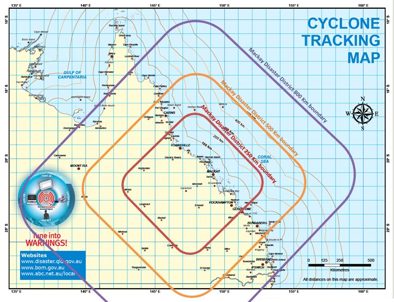
SEVERE WEATHER & CYCLONE PLAN
1. INTRODUCTION
The Disaster Management Act 2003 S13(1) defines a disaster as a serious disruption in a
community, caused by the impact of an event, that requires a significant coordinated response
by the State and other entities to help the community recover from the disruption. Disasters
that may affect Mackay Airport include:
Tropical cyclones
Gale force winds
Storms
Storm surges
Earthquake
Tsunamis
Volcanic ash
Tornados
The Mackay Airport Severe Weather and Cyclone Plan has been prepared to counter potential
danger and damage that may occur as a result of a disaster.
Post disaster where airport infrastructure suffers significant damage impacting on airport
operations, the Aerodrome Emergency Committee (AEC) would be convened to manage a
disaster recovery program as per the Mackay Airport ‘Airport Emergency Plan’ (AEP).
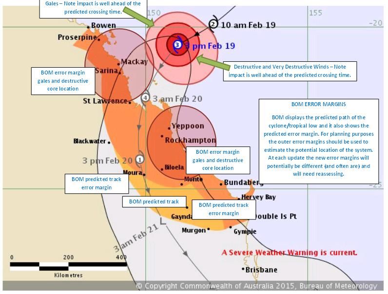
As a lesson learnt from Cyclone Marcia, the Mackay Regional Council Local Disaster
Management Group (LDMG) have developed, with the assistance of the Bureau of Meteorology
(BOM), reference documents Cyclone/Tropical Low Timing Calculator, Cyclone/Tropical Low
Distance Map and Cyclone/Tropical Low Error Margins to assist with planning (refer to
Annexures A and B).
For quality control purposes, this document is only valid on the day it is printed. Official versions are stored on the intranet.
This copy was last saved: 09/11/2018, last printed: 09/11/2018
9020_MKY_SevereWeatherandCyclonePlan_V5_EffectiveDate_08/11/2018_ReviewDate_08/11/2019 Page 4 of 14Severe Weather & Cyclone Plan SOP
2. Cyclone State Advise, Notification and Action
STAGE ACTIVITY WIND SPEED NOTIFICATION COMMENTS/ACTION
Stage 1 CYCLONE WATCH - Gale Force Winds (above Advice via SMS by Cyclone watch:
Initiated by Bureau of 75km/h) (41kt) 24 - 48 hrs Mackay Airport NQA team members to ensure company procedures are followed as per SOPs and review company
Meteorology (BOM) by away procedures
announcement of a Tenants review Severe Weather and Cyclone Plan and company procedures
Cyclone affecting the Secure or remove non-essential equipment from open areas
Check emergency stores equipment (fuel, generators, radio’s etc.)
region.
Stage 2 CYCLONE WARNING - Gale Force Winds (above Advice via SMS by Cyclone Warning:
Initiated by BOM by 75km/h) (41kt) 24 hrs Mackay Airport Severe Weather and Cyclone Committee is convened
announcement of a away Complete initial preparation
Cyclone affecting the Implement company procedures
region. Complete removing / securing non-essential equipment
Remove / secure light aircraft
Continue to monitor cyclone activity via BOM website / media etc.
Stage 3 CYCLONE WARNING Gale Force Winds (above Advice via SMS by Cyclone Warning Current:
CURRENT – BOM 100 km/h) (54kt) 6 -12 hrs Mackay Airport Commence partial shutdown of facilities, documents computers etc.
Monitoring System away Consider sending non-essential staff home. Light aircraft relocated / stored /securely tied down
Consider flood precautions / sandbagging etc.
Continue to monitor cyclone activity via BOM website / media etc.
Stage 4 CYCLONE WARNING Gale Force Winds (above Advice via SMS by Cyclone Warning Current:
CURRENT – BOM 100 km/h) (54kt) at airport Mackay Airport Stage shut down of airport facilities, including terminal, airport ground lighting etc.
Monitoring System are 3 - 6 hrs away ATC, ARFF, Airlines will cease operations as soon as possible after declaration of Stage 4
Airport tenants expected to complete their own shut down of their own operations in a similar timeframe
After consultation with ATC, and upon departure of last aircraft, Mackay Airport Manager Aviation
Operations will issue a NOTAM advising of non-availability of airport facilities (from time/date)
All staff should have departed from airport. Severe Weather and Cyclone Committee is stood-down.
Stage 5 CYCLONE WARNING Gale Force Winds (above Nil Advice by Cyclone Warning Current:
CURRENT 100 km/h) (54kt) have Mackay Airport ALL AIRPORT OPERATIONS HAVE CEASED
commenced
Stage 6 CYCLONE WARNING Gale Force Winds (above Nil Advice by Cyclone Warning Current:
CURRENT 100 km/h) (54kt) have Mackay Airport ALL AIRPORT OPERATIONS REMAIN CEASED
passed ALL CLEAR NOT YET ANNOUNCED – STAGE 5 MAY BE RE-DECLARED
Stage 7 CYCLONE WARNING MAY Gale Force Winds have Nil Advice by CYCLONE WARNING MAY STILL EXIST
STILL EXIST passed Mackay, though a Mackay Airport Cyclone Committee to reconvene
Cyclone warning may still Commence call-in of essential staff to return Airport to normal operational status
exist NOTAM to be lifted by Mackay Airport Manager Aviation Operations
Timing to be determined by Airport Cyclone Committee and through the Chair
For quality control purposes, this document is only valid on the day it is printed. Official versions are stored on the intranet.
This copy was last saved: 09/11/2018, last printed: 09/11/2018
9020_MKY_SevereWeatherandCyclonePlan_V5_EffectiveDate_08/11/2018_ReviewDate_08/11/2019 Page 5 of 14SEVERE WEATHER & CYCLONE PLAN
STAGE ACTIVITY WIND SPEED NOTIFICATION COMMENTS/ACTION
Stage 8 Cyclone Warning Declaration of All Clear by Advice via SMS by Cyclone Warning Cancelled
cancelled District Disaster Manager Mackay Airport Staff returning to Airport to re-commence operations
Declaration of all Tenants clean-up operations commence
clear Tenants to liaise with Mackay Airport Assets Department regarding loss of services and damage to
facilities
NOTE: Following a severe cyclone Stage 8 may extend to several days as clean up continues
For quality control purposes, this document is only valid on the day it is printed. Official versions are stored on the intranet.
This copy was last saved: 09/11/2018, last printed: 09/11/2018
9020_MKY_SevereWeatherandCyclonePlan_V5_EffectiveDate_08/11/2018_ReviewDate_08/11/2019 Page 6 of 14Severe Weather & Cyclone Plan SOP
3. TROPICAL CYCLONE WARNING SYSTEM
Tropical Cyclone Advices are issued by the BOMs Tropical Cyclone Warning Centre and broadcast by
radio and television stations.
Information is also available directly from BOM by:
Method Details Contact Details
Fax Poll Forecast Track Map 1902 935 277
Telephone Cyclone Advice 1300 659 212
Internet All Weather and Warnings www.bom.gov.au
4. TROPICAL CYCLONE FORECAST THREAT AND TRACK MAPS
The Bureau of Meteorology provides a Tropical Cyclone Forecast Threat and Track Map displaying the
forecast positions of each tropical cyclone up to 24 hours and is available on BOM’s web page at
http://www.bom.gov.au/cyclone.
5. TROPICAL CYCLONE CATEGORY SYSTEM
Category Max. Wind Gust Typical Effects
90 – 125km/h Tropical Cyclone: Negligible house damage, damage to some
1 (48 – 67kt) crops, trees, caravans and craft may drag moorings
Tropical Cyclone: Minor house damage, significant damage to
125 – 164km/h
2 (67 – 89kt)
signs, trees and caravans, heavy damage to some crops, risk
of power failure, small craft may break moorings
165 – 224km/h Severe Tropical Cyclone: Some roof and structural damage,
3 (90 – 120kt) power failure likely
Severe Tropical Cyclone: Significant roofing loss and structural
225 – 279km/h
4 (121 – 150kt)
damage, blown away, dangerous airborne debris, widespread
power failures
< 280km/h Severe Tropical Cyclone: Extremely dangerous with
5 (> 151kt) widespread destruction
For quality control purposes, this document is only valid on the day it is printed. Official versions are stored on the intranet.
This copy was last saved: 09/11/2018, last printed: 09/11/2018
9020_MKY_SevereWeatherandCyclonePlan_V5_EffectiveDate_08/11/2018_ReviewDate_08/11/2019 Page 7 of 14SEVERE WEATHER & CYCLONE PLAN
6. SEVERE WEATHER AND CYCLONE COMMITTEE
6.1 The Severe Weather and Cyclone Committee is convened at:
Stage 2 Cyclone Warning, and/or
As determined by BOM weather warnings for severe weather and disasters including
storms, storm surges, earthquake, tsunamis, volcanic ash and tornados.
6.2 Chair of the Severe Weather and Cyclone Committee in succession is:
General Manager
Manager Aviation Operations
6.3 Membership of the Severe Weather and Cyclone Committee is:
Airport Incident Management Team:
General Manager
Manager Aviation Operations
Manager Infrastructure, Maintenance, Safety & Environment
Supervisor Airside Safety
Terminal Operations Coordinator
Infrastructure Maintenance Supervisor
Infrastructure Maintenance Coordinator
Aviation Administration Officer
Cairns Airport remote support may include:
Manager Human Resources
Aerodrome Manager
Manager ICT
Security Manager
Corporate Affairs Manager
Technical Services Coordinator
6.4 The core members of the Mackay Airport Severe Weather and Cyclone Committee comprise of:
Mackay Airport staff
Bureau of Meteorology (advice received via phone or email)
Airservices Australia
Air Traffic Control
Infrastructure Support Services
Aviation Rescue and Fire Fighting
Aerocare
Qantas Freight
Oznorth Services
Security Contractor
General Aviation Representatives
CQ Rescue
Secure Park
Catercare
Relay
For quality control purposes, this document is only valid on the day it is printed. Official versions are stored on the intranet.
This copy was last saved: 09/11/2018, last printed: 09/11/2018
9020_MKY_SevereWeatherandCyclonePlan_V5_EffectiveDate_08/11/2018_ReviewDate_08/11/2019 Page 8 of 14SEVERE WEATHER & CYCLONE PLAN
O’Brien Electrical Services, Mackay
Virgin Australia Technician
6.5 Note
6.5.1 The Chair of the Severe Weather and Cyclone Committee will advise any change to the
operational status of the Airport to the Chief Executive Officer and Corporate Affairs Manager.
6.5.2 The Manager Aviation Operations (or if unavailable the Chair of the Severe Weather and
Cyclone Committee) will advise any change to the operational status of the Airport to:
Mackay Local Disaster Management Group (LDMG)
Local Disaster Coordinator Jason Devitt
Telephone 074965 9007
Mobile 0418 782 870
Email disaster@mackay.qld.gov.au
Mackay District Disaster Management Group
Telephone 04 4840 0800 or
07 4840 0814
6.5.3 Manager Aviation Operations (or if unavailable) the Chair of the Severe Weather and Cyclone
Committee will log on to the BOM website in preparation for the meeting.
For quality control purposes, this document is only valid on the day it is printed. Official versions are stored on the intranet.
This copy was last saved: 09/11/2018, last printed: 09/11/2018
9020_MKY_SevereWeatherandCyclonePlan_V5_EffectiveDate_08/11/2018_ReviewDate_08/11/2019 Page 9 of 14SEVERE WEATHER & CYCLONE PLAN
ANNEXURE A: Trigger and Action Documents
Cyclones & Tropical Lows – Triggers and Actions
In preparation for making decisions regarding triggers and actions of the Local Disaster Management Plan
reference will need to be made to Appendices:
Cyclone/Tropical Low Timing Calculator
Cyclone/Tropical Low Distance Map
Cyclone/Tropical Low Error Margins
It is important to understand that advice from the Bureau of Meteorology and other sources are based on
best knowledge however due to the nature of cyclones and tropical lows this information cannot be
relied upon as providing defi8nitive tracks, timings and intensities. Systems can slow down or speed up.
Therefore the triggers and actions contained in this section rely primarily on distance.
Whilst distance is a primary driver, timing is important to consider. For some State support a minimum of
24 hours’ notice is required (e.g. Cyclone Shelter Management Team deployments). The expected timing
of the event may also coincide with weekends, [public holidays or other events. The timing of the event
may necessitate the need to bring the timing of the activation level forward or some actions forward.
The following table may be used to determine the timing for actions:
Activation
Level Triggers Action/s
CYCLONE/TROPICAL LOW IS 1. LDMG will primarily consist of the LDC and Chair.
2. LDMG emailed.
CYCLONE/TROPICAL LOW
800KM FROM OUR COASTLINE
3. Email to Council Staff, Managers, Directors, Emergency
Other triggers can also be the Management Teams (ELO’s, PSC Teams, Recovery,
expected category (intensity), the Special Needs Groups).
speed of travel, its expected track 4. Contact Department of Education, Training and
and consideration must be given Employment for potential handover of Public Cyclone
to error margins. Shelter.
5. Consider RFA for Public Cyclone Shelter Management
ALERT
E.g. If the system is travelling at
Team(s).
30km/h and an allowance of 5
hours is given for the initial 6. Create folder naming for event in Guardian.
impacts (prior to the core) then 7. Active monitoring of the system to commence.
there is only 22 hours 8. Checking of tides and potential storm surge scenarios
STORM SURGE
preparation time available. At 9. Media to commence preparation messaging to the
10km/h there is 75 hours of community using Facebook, TV, radio.
preparation time. Be aware
10. No deployments of essential staff/SES out of area.
systems can speed up.
For quality control purposes, this document is only valid on the day it is printed. Official versions are stored on the intranet.
This copy was last saved: 09/11/2018, last printed: 09/11/2018
9020_MKY_SevereWeatherandCyclonePlan_V5_EffectiveDate_08/11/2018_ReviewDate_08/11/2019 Page 10 of 14SEVERE WEATHER & CYCLONE PLAN
Activation
Level Triggers Action/s
CYCLONE/TROPICAL LOW IS 1. LDCC set up for operations (rosters, inform staff of
500KM FROM OUR COASTLINE potential start time).
2. Handover of Public Cyclone Shelter to LDMG.
CYCLONE/TROPICAL LOW
Other triggers can also be the 3. Basic set up of Public Cyclone Shelter (prepare team, set
expected category (intensity), the up registration areas, check inventory and operational
speed of travel, its expected track capacity – do not set up chairs at this time).
and consideration must be given 4. Identify and make ready any Places of Refuge.
to error margins. 5. LDMG Meeting to commence on advice of Chair.
6. LDMG emailed.
LEAN FORWARD
E.g. If the system is travelling at 7. 24 hour monitoring of event by staff to commence.
30km/h and an allowance of 5 8. Continued checking of tidal and storm surge scenarios.
hours is given for the initial 9. Media messaging in relation to preparedness and
impacts (prior to the core) then evacuations to increase.
there is only 12 hours 10. Voluntary evacuations and self-evacuations to
preparation time available. At commence.
10km/h there is 45 hours of 11. Evacuation Plans to be activated.
STORM SURGE
preparation time. Be aware 12. Ensure Emergency Alert templates and polygons are
systems can speed up. correct.
13. SITREP/emails to all council staff and Emergency
Management Teams.
14. Assessment of localised flood risks and take necessary
action.
CYCLONE/TROPICAL LOW IS 1. Activation of all relevant sub plans.
CYCLONE/TROPICAL LOW
250KM FROM OUR COASTLINE 2. LDMG stood-up with regular meetings.
3. Regular emails to Managers and LDMG.
Other triggers can also be the 4. Public Cyclone Shelter opened for evacuees (if expected
expected category (intensity), the to be Category 2 or higher).
speed of travel, its expected track 5. Places of Refuge prepared and opened for overflow
and consideration must be given from Public Cyclone Shelter.
STAND-UP
to error margins. 6. Conduct evacuations.
7. Media – providing all messaging and event information.
E.g. If the system is travelling at 8. Consider the use of Emergency Alerts.
30km/h and an allowance of 5 9. Event Action Plans written.
hours is given for the initial 10. Rapid Damage Assessments conducted, collated and
STORM SURGE
impacts (prior to the core) then distributed.
there is only 3 hours preparation 11. Undertake response actions (RFA’s/Guardian).
time available. At 10km/h there 12. Stand-up Recovery and Relief Groups (pre-empt
is 20 hours of preparation time. requests from the community).
Be aware systems can speed up.
Cyclone/Tropical Low has passed 1. LDMG stood down.
TROPICAL LOW
out of our area 2. LDCC stood down
CYCLONE/
3. Shelter handed back to DETE.
STAND DOWN
No more response RFA’s 4. Debrief conducted (hot/full) and After Action Review
undertaken.
No further need for a multi- 5. Handover to Relief & Recovery.
agency response. 6. Post Event Evaluation conducted.
STORM
SURGE
Have transitioned back to core
business.
For quality control purposes, this document is only valid on the day it is printed. Official versions are stored on the intranet.
This copy was last saved: 09/11/2018, last printed: 09/11/2018
9020_MKY_SevereWeatherandCyclonePlan_V5_EffectiveDate_08/11/2018_ReviewDate_08/11/2019 Page 11 of 14Severe Weather & Cyclone Plan SOP For quality control purposes, this document is only valid on the day it is printed. Official versions are stored on the intranet. This copy was last saved: 09/11/2018, last printed: 09/11/2018 9020_MKY_SevereWeatherandCyclonePlan_V5_EffectiveDate_08/11/2018_ReviewDate_08/11/2019 Page 12 of 14
SEVERE WEATHER & CYCLONE PLAN

ANNEXURE B: LMDG Cyclone Tracking Map

For quality control purposes, this document is only valid on the day it is printed. Official versions are stored on the intranet.
This copy was last saved: 09/11/2018, last printed: 09/11/2018
9020_MKY_SevereWeatherandCyclonePlan_V5_EffectiveDate_08/11/2018_ReviewDate_08/11/2019                                                             Page 13 of 14
SEVERE WEATHER & CYCLONE PLAN

For quality control purposes, this document is only valid on the day it is printed. Official versions are stored on the intranet.
This copy was last saved: 09/11/2018, last printed: 09/11/2018
9020_MKY_SevereWeatherandCyclonePlan_V5_EffectiveDate_08/11/2018_ReviewDate_08/11/2019                                                             Page 14 of 14
You can also read