St. Tammany Parish, Louisiana Feasibility Study - June 2021 Appendix G - Real Estate Plan - US Army Corps of Engineers ...
←
→
Page content transcription
If your browser does not render page correctly, please read the page content below
Mississippi Valley Division,
                        Regional Planning and Environment Division South

St. Tammany Parish, Louisiana
Feasibility Study

Appendix G – Real Estate Plan

June 2021
St. Tammany Parish, Louisiana Feasibility Study
Appendix G – Real Estate Plan

 Contents
                     5
 Introduction 5
     1.1       Project Authorization ..............................................................................................................................5
     1.2       STUDY AREA ........................................................................................................................................5
     1.3       TENTATIVELY SELECTED PLAN ........................................................................................................6
                 TSP Measure 1: South Slidell and West Slidell Levee and Floodwall System-Federal Hurricane
        and Storm Risk Reduction Levee and Floodwall.........................................................................................10
                         TSP Measure 2: Bayou Patassat Channel Improvements in Slidell, LA....................................13
                         TSP Measure 3: Mile Branch Channel Improvements in Covington, LA. ..................................14
                         TSP Measure 4: Nonstructural Elevations and Flood Proofing ..................................................15
                         Mitigation ......................................................................................................................................17
                     18
 Non-Federal Sponsor .........................................................................................................................................18
     2.1       Assessment of Non-Federal SPonsor Capability .................................................................................18
     2.2       Non-Federal Sponsor Risk Notification ................................................................................................18
                     19
 Lands Required for the Project.........................................................................................................................19
     3.1       Lands, Easements, and Rights-of-Way (LER) .....................................................................................19
                         Measure 1: Federal Hurricane and Storm Risk Reduction Levee and Floodwall. .......................19
                         Measure 2: Bayou Patassat Channel Improvements ..................................................................20
                         Measure 3: Mile Branch Channel Improvements .........................................................................20
     3.2       Estates to be Acquired .........................................................................................................................20
     3.3       Non-standard Estate – Nonstructural Project Feature .........................................................................23
     3.4       Facility/Utility Relocations ....................................................................................................................23
                     24
 Federal Lands .....................................................................................................................................................24
     4.1       Existing Federal Projects .....................................................................................................................24
                         USACE Southeast Louisiana Urban Flood Control Project .........................................................24
     4.2       Federally Owned Lands .......................................................................................................................25
     4.3       Navigation Servitude ............................................................................................................................26
                     27
 Induced Flooding ...............................................................................................................................................27
                     28
 Uniform Relocations Assistance (P.L. 91-646, Title II as Amended).............................................................28

                                                                                              ii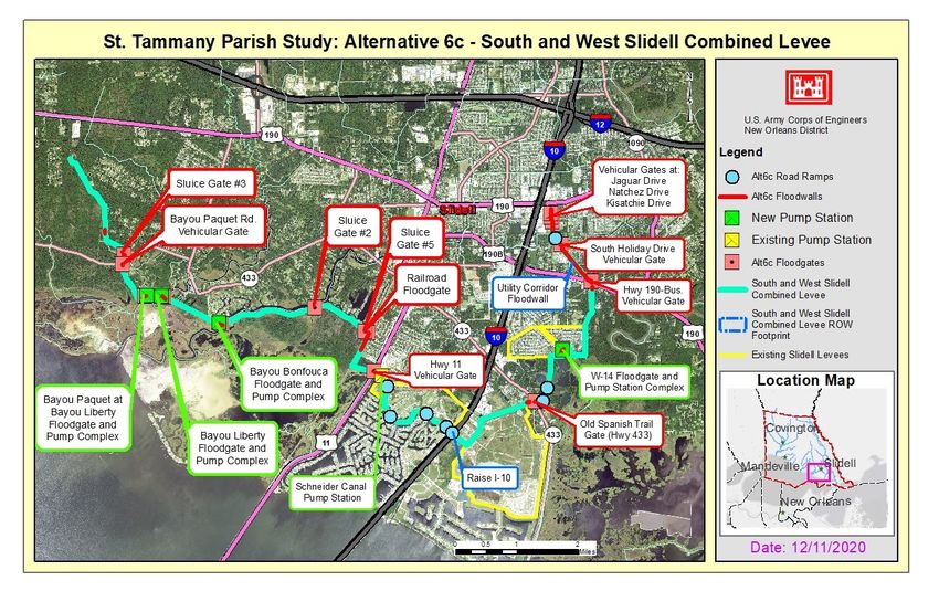
St. Tammany Parish, Louisiana Feasibility Study
                                                                                                      Appendix G – Real Estate Plan

                   29
Other Impacts to Lands Required for the Project .......................................................................................... 29
    7.1       Timber/MineralS/Row Crop Activity ..................................................................................................... 29
    7.2       Oyster Leases...................................................................................................................................... 29
    7.3       Hazardous, Toxic, and Radioactive Waste ......................................................................................... 29
    7.4       Zoning In Lieu of Acquisition ............................................................................................................... 29
                   30
Real Estate Costs .............................................................................................................................................. 30
    8.1       Real Estate Costs – Structural Project Features ................................................................................. 30
    8.2       Real Estate Cost – Nonstructural Project Features............................................................................. 30
                   32
Real Estate Acquisition Schedule .................................................................................................................... 32
    9.1       Real Estate Schedule – Structural Project Features ........................................................................... 32
    9.2       Real Estate Schedule – Nonstructural Project Features ..................................................................... 32
                   33
Landowner Concerns ........................................................................................................................................ 33
                   34
Review and Approval ........................................................................................................................................ 34

                                                 LIST OF TABLES
Table G:3-1. LER – Alignment for Measure 1 ..................................................................................................... 19
Table G:3-2. LER – Mile Branch Channel Improvement ..................................................................................... 20
Table G:8-1. Estimated Real Estate Costs for the TSP - Structural .................................................................... 30
Table G:8-2. Estimated Real Estate Costs for the TSP - Nonstructural .............................................................. 31

                                               LIST OF FIGURES
Figure G:1-1 St. Tammany Parish Feasibility Study Area ..................................................................................... 6
Figure G:1-2 St. Tammany Parish Feasibility Study Tentatively Selected Plan.................................................... 7
Figure G:1-3 Measure 1 Levee/Floodwall ............................................................................................................. 9
Figure G:1-4 Combined Levee and Project Structural Feature Locations .......................................................... 10
Figure G:1-5 Bayou Patassat Channel Improvements ........................................................................................ 13
Figure G:1-6 Mile Branch Channel Improvements .............................................................................................. 14

                                                                        iii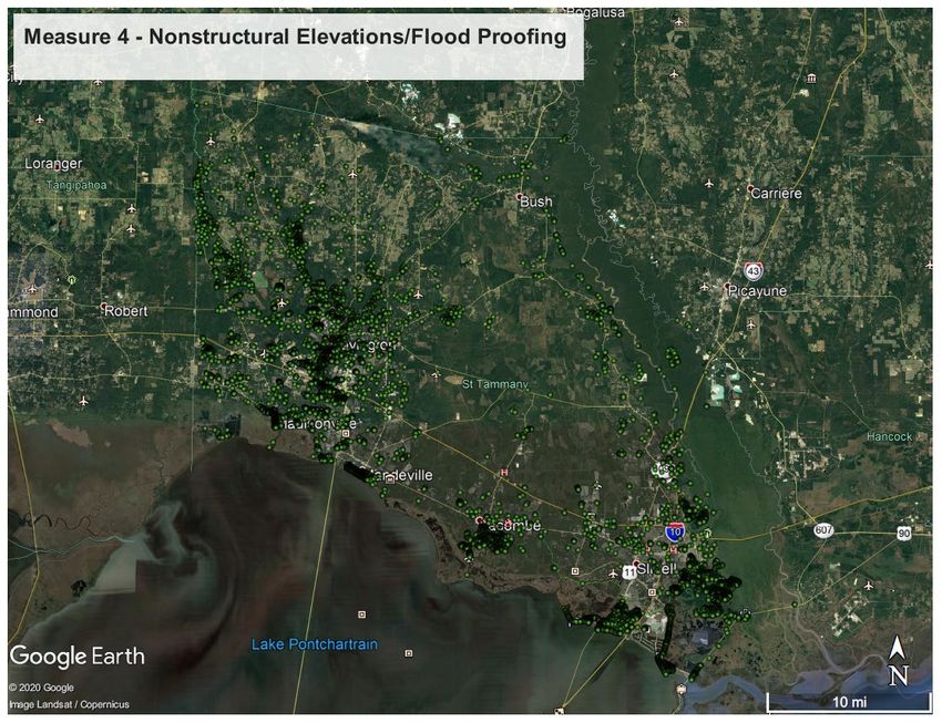
St. Tammany Parish, Louisiana Feasibility Study
Appendix G – Real Estate Plan

 Figure G:1-7 Nonstructural Elevations/Flood Proofing ........................................................................................16
 Figure G:4-1. Southeast Louisiana (SELA) Projects............................................................................................24
 Figure G:4-2. Big Branch Marsh NWR – Alt 6c Levee Alignment ........................................................................25

                                           ATTACHMENT(S)
 ATTACHMENT A                   ASSESSMENT OF NON FEDERAL SPONSOR CAPABILITY

                                                                              iv
St. Tammany Parish, Louisiana Feasibility Study
                                                                        Appendix G – Real Estate Plan

                                        Introduction
      The U.S. Army Corps of Engineers (USACE), Mississippi River Valley Division (MVD), New
      Orleans District (MVN) Real Estate Division has prepared this Real Estate Plan (REP) in
      support of the Draft Integrated Feasibility Report (DIFR) with Draft Environmental Impact
      Statement (EIS) for St. Tammany Parish, Louisiana.
      The St. Tammany Parish, Louisiana Feasibility Study is a comprehensive investigation and
      feasibility study of both Coastal Storm Risk Management (CSRM) and Flood Risk
      Management (FRM) problems and solutions. The Non Federal Sponsor (NFS) for the study
      is the Coastal Protection Restoration Authority Board (CPRAB) (refer to Section 2 for further
      discussion).
1.1   PROJECT AUTHORIZATION
      The St. Tammany Parish, Louisiana Feasibility Study was authorized as a part of the 2016
      Water Infrastructure Improvements Act, which included as part of the legislation the Water
      Resources Development Act of 2016. Subsequently, the Bipartisan Budget Act of 2018
      (Public Law 115-123) appropriated supplemental funds for the study. More information
      regarding project authorization is provided in the DIFR, Section 1.2.
1.2   STUDY AREA
      The study area encompasses all of St. Tammany Parish, which is approximately 1,124
      square miles and located in southeastern Louisiana (see Figure 1-2). St. Tammany Parish is
      located on the northeast shore of Lake Pontchartrain and is home to over 258,110 residents.
      The parish is uniquely located at the crossroads of three interstates (I-10, I-12, and I-59) and
      transportation waterways to the Gulf of Mexico.
      The State of Mississippi with the Pearl River creates the eastern boundary of the study area.
      Lake Pontchartrain serves as the southern border and is one of the largest estuaries in the
      United States.
      The Southeastern Louisiana National Wildlife Refuge Complex Headquarters in Lacombe is
      also located near the southern boundary. Tangipahoa Parish is located along the western
      boundary and Washington Parish is located to the north. Most of St. Tammany Parish’s
      population resides along the edge of Lake Pontchartrain, and many commute into New
      Orleans, with Mandeville, Slidell, and Covington serving as residential communities. Major
      communities in the study area include Slidell, Mandeville, Covington, Abita Springs, Pearl
      River, and Madisonville. St. Tammany Parish is the fastest-growing parish in Louisiana and
      one of the fastest-growing communities in the nation. Major industries in the study area are
      health care and social assistance, retail trade, professional, scientific, and technical
      services, construction, finance, and insurance.

                                                5
St. Tammany Parish, Louisiana Feasibility Study
Appendix G – Real Estate Plan

                       Figure G:1-1 St. Tammany Parish Feasibility Study Area

 1.3       TENTATIVELY SELECTED PLAN
 The Tentatively Selected Plan (TSP) is a comprehensive plan to address flooding parish-
 wide, which includes CSRM, FRM, and nonstructural features.
 The TSP comprises these measures:

       •    Alignment that includes levee and floodwall sections in west and south Slidell.

       •    Bayou Patassat channel improvements in Slidell.

       •    Mile Branch channel improvements in Covington.Nonstructural home elevations and
            floodproofing for the rest of the parish based on structures located in the 50-year
            flood plain (residual risk)
 Figure G:1-2 below shows an overview of the TSP features.
 If the TSP is authorized for construction and implemented, the NFS will be required
 to execute a model structural FRM Project Partnership Agreement (PPA) with the
 Department of the Army. This model PPA provides numerous items of local
 cooperation required to be provided by the NFS. The PPA requires, among other
 things, that the NFS provide all real property interests, placement area
 improvements, and relocations required for construction, operation, and
 maintenance of the project. The NFS must also prevent obstructions or
 encroachments on the project (including prescribing and enforcing regulations to
 prevent such obstructions or encroachments) that might reduce the level of flood
 risk reduction the project affords, hinder operation and maintenance of the project,

                                                        6
St. Tammany Parish, Louisiana Feasibility Study
                                                                   Appendix G – Real Estate Plan

or interfere with the project's proper function. In addition, the NFS is responsible for
undertaking any investigations to identify the existence and extent of any hazardous
substances regulated under the Comprehensive Environmental Response,
Compensation, and Liability Act (CERCLA) (42 U.S.C. 9601-9675), that may exist
in, on, or under real property interests required for construction , operation, and
maintenance of the project. As between the Government and the NFS, the NFS
shall be considered the operator of the project for purposes of CERCLA liability.

        Figure G:1-2 St. Tammany Parish Feasibility Study Tentatively Selected Plan

The Tentatively Selected Plan (TSP) is a comprehensive plan to address flooding parish-wide,
which includes CSRM, FRM, and nonstructural measures.

   •   South Slidell and West Slidell Levees (from Alternative 6c)
       The levee compromises approximately 16.3 miles (85,900 feet) of alignment with a
       combination of 14 miles of levees (73,700 feet) and 2.3 miles (12,200 feet) of
       floodwall. The I-10 would be raised to the preliminary design elevation of 15 feet. The
       levee and floodwall alignment would impact approximately 162 173 acres of
       construction area. The levee alignment would require approximately 1,528,000 cubic
       yards of fill. A more detailed description of the levee alignment is provided later in this
       section. There would be five pump stations, four gate complexes, and one channel

                                            7
St. Tammany Parish, Louisiana Feasibility Study
Appendix G – Real Estate Plan

         floodgate. There would also be a total of three sluicegates, seven vehicular gates,
         one railroad gate, and seven ramps. Refer to Appendix D – Engineering Appendix for
         a detailed description of the additional structural features.

     •   Bayou Patassat Clearing and Snagging (from Alternative 5)
         Bayou Patassat is a small tributary of Bayou Bonfouca also located in Slidell,
         Louisiana. The preliminary design of the channel improvements assumes an existing
         bank elevation of 1 foot, and a 10 feet bottom width at elevation (-) 5 feet. The bank is
         at 1V:3H slope. The work will be located between Bayou Vincent pump station and
         Highway 11. Approximately 0.17 miles (900 feet) of clearing and snagging will occur
         in Bayou Patassat. A more detailed description of this measure is provided later in
         this section.

     •   Mile Branch Channel Improvements (from Alternative 8)
         The Mile Branch channel improvements start at the intersection of Mile Branch and
         Highway 190, crossing Highway 190 Business, and end at the intersection of Mile
         Branch and the Tchefuncte River. This alternative consists of channel improvements
         on the lower 2.15 miles (11,341 feet channel) of Mile Branch in Covington. The
         preliminary design assumes an existing bank elevation of 1 foot, and a 10-feet bottom
         width at elevation (-) 5 feet. The bank is at 1V:3H slope. The improvements include
         clearing and grubbing and mechanical dredging of the channel. The channel bottom
         will be lowered by 5 feet. Approximately 20 acres of channel will be cleared and
         grubbed prior to mechanical dredging. An assumed maximum of 130,000 cubic yards
         of material may be mechanically dredged from the channel. A more detailed
         description of this measure is provided later in this section.

     •   Nonstructural Elevations and Flood Proofing (from Alternative 2)
         A total of 8,498 homes will be elevated to the future 100-year stage up to 13 feet and
         non-residential structures floodproofed up to 3 feet. The floodproofing of these
         structures addresses the structures in the 50-year floodplain that are not included in
         the areas benefitted from the structural features of the TSP. It is estimated that 6,643
         homes will be elevated and 1,855 structures floodproofed. These structures counts
         are preliminary and will continue to be evaluated and refined. A more detailed
         description of this measure is provided later in this section.
 An estimated 67 private landowners would be impacted by the implementation of the
 structural features of the TSP. The necessary estates and acreages that would be acquired
 if the TSP is implemented are in Section 3 (Table G:3-1).

                                                      8
St. Tammany Parish, Louisiana Feasibility Study
                                    Appendix G – Real Estate Plan

Figure G:1-3 Measure 1 Levee/Floodwall

             9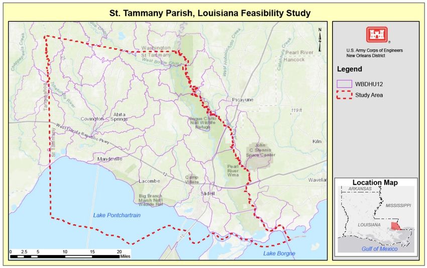
St. Tammany Parish, Louisiana Feasibility Study
Appendix G – Real Estate Plan

              Figure G:1-4 Combined Levee and Project Structural Feature Locations

         TSP Measure 1: South Slidell and West Slidell Levee and Floodwall System-
         Federal Hurricane and Storm Risk Reduction Levee and Floodwall.
 Measure 1 provides a total of 16.3 miles (85,900 feet) of hurricane and storm risk reduction
 to the southern and western portion of the city of Slidell. The necessary estates and
 acreages that would be acquired if the TSP is implemented are discussed in Section 3
 (Table G:3-1).
 The Measure includes a proposed total of approximately 14 miles (73,700 feet) of federal
 hurricane protection levees constructed in two separate (non-continuous) federal levee
 segments (Segment 1 and Segment 2 of the levee).
 In addition, there will be 2.3 miles (12,200 feet) of two separate (non-continuous) segments
 of a floodwall (Segment 1 and Segment 2 of the floodwall) of a hurricane protection floodwall
 in the City of Slidell, Louisiana.
 Starting on the western side, the new federal levee alignment would commence on the south
 side of US Highway 190 from southwest of Bayou Paquet. This new western alignment
 would consist of a levee with a floodwall segment on the east side of Bayou Paquet Road.

                                                   10
St. Tammany Parish, Louisiana Feasibility Study
Appendix G – Real Estate Plan
The new alignment would cross Bayou Liberty and Bayou Bonfouca, along the northern
perimeter of the Big Branch Marsh National Wildlife Refuge and would meet the Norfolk
Southern Railway Corp railroad tracks west of US Highway 11 in the vicinity of Delwood
Pump Station in Slidell.
The new alignment would continue across the railroad tracks into South Slidell. Then the
new alignment would transition into a floodwall running on the east side of the railroad track
from Delwood Pump Station (Sun Valley Drive) in a north to south direction. The new
floodwall would transition into a new levee just south of the First Baptist Church Christian
School, where it would turn east and then south.
This reach would consist of a new levee alignment with new floodwall segments. This reach
would include the Schneider Canal Pump Station improvements (which are assumed to
remain within the same footprint as the existing facility).
The new levee would tie to a segment of the existing Oak Harbor levee along Oak Harbor
Boulevard (existing levee would be raised to Elevation 15 feet), and then the I-10 would be
raised to ramp over the new levee section.
The new levee would tie to a section of the northern perimeter of the existing Lakeshore
Estates levee (existing levee would be raised to Elevation 15 feet). The new levee would
cross LA Highway 433 and turn north and would tie to a section of the existing King’s Point
west levee (existing levee would be raised to Elevation 15 feet).
The new alignment would connect to the new pump station at the W-14 canal and would tie
to the existing King’s Point east levee (existing levee would be raised to Elevation 15 feet).
The new levee would continue north towards US Highway 190 Business (Fremaux Ave).
The new levee would cross US Highway 190 Business (Fremaux Ave) and would transition
into a floodwall across US Highway 190 Business.
This levee alignment would require 1,528,000 cubic yards of fill (borrow material) (includes
30 percent contingency).
The new floodwall would run on the west side of the CLECO Corporate Holdings, LLC utility
corridor and cross South and North Holiday Drives. The new floodwall would exit the utility
corridor to run on the east side of Carol Drive, would continue north on the east side of
Yaupon Drive, and would terminate at Manzella Drive (one block south of Gause Boulevard).
The I-10 would be raised to ramp over the new levee section by constructing ramps to the
preliminary design elevation of 15 feet. The existing elevation of the I-10 at the proposed
location is approximately 12.8 feet as per LIDAR raster dataset. This proposed location is
the highest elevation of the I-10 in the vicinity of the proposed alignment. The I-10 elevation
is lower (approximately 10 feet) on the adjacent areas. This feature would be designed in the
feasibility level of design for the study.
The new floodwall segments would be as follows. Starting on the west:
11St. Tammany Parish, Louisiana Feasibility Study
Appendix G – Real Estate Plan
• 0.07 miles (350 feet) floodwall segment passing through several properties. Top of
wall elevation of 17 feet. The construction area would be 0.4 acres.
On the east side of the railroad tracks:
• 0.3 miles (1,600 feet) of T-wall along Railroad between Delwood Pump Station and
First Baptist Church
• 0.06 miles (300 feet) Old Spanish Trail Floodwall segment (construction area would
be 0.3 acres).
• Across from LA Highway 433, there would be 0.09 miles (450 feet) Old Spanish Trail
Floodwall segment by Espirit du Lac Street (construction area would be 0.5 acres).
• 0.04 miles (200 feet) floodwall segment near Belaire Drive (construction area would
be 0.2 acres).
• The next floodwall segment would be along the north side of US Highway 190
Business (Fremaux Ave) for 0.08 miles (430 feet) and then the new floodwall would
turn into the CLECO Corporate Holdings, LLC utility corridor for approximately 1.4
miles (7,200 feet) and would terminate at Manzella Drive. The total length of this new
floodwall alignment would be 1.5 miles (7,700 feet) long (total construction area would
be 9 acres).
The total levee alignment would impact approximately 162 acres of construction area. This
levee alignment would require approximately 1,528,000 cubic yards of fill. The 2 Floodwall
segments will encompass approximately 11 acres.
The proposed pump stations and control structures included in this Measure will encompass
an approximate 63 acres. There will be a total of three sluice gates, seven vehicular gates,
one railroad gate, and seven ramps included in the combined levee and floodwall alignment.
12St. Tammany Parish, Louisiana Feasibility Study
Appendix G – Real Estate Plan
Figure G:1-5 Bayou Patassat Channel Improvements
TSP Measure 2: Bayou Patassat Channel Improvements in Slidell, LA.
The Bayou Patassat Channel Improvements would be performed between Bayou Vincent
Pump Station and US Highway 11. Bayou Patassat is a small tributary of Bayou Bonfouca.
The preliminary design of the channel improvements assumes an existing bank elevation of
1 foot, a 10-feet bottom width at elevation (-) 5 feet, and bank slopes at 1V:3H slope. The
work would be located between Bayou Vincent Pump Station and US Highway 11. Land
access to the site would be through Bayou Lane or the existing pump station access road.
The lands required for the implementation of this Measure are all public property and owned
by either St. Tammany Parish or the city of Slidell, LA. Possible staging areas would include
the city-owned land around the bayou and the Bayou Vincent pump station or at the grassy
area at the end of Bayou Lane. It is assumed that access to the bayou would be via the city-
13St. Tammany Parish, Louisiana Feasibility Study
Appendix G – Real Estate Plan
owned property along the channel. Note that there is enough right-of-way (ROW) for two-
way access on the northside of the channel. If necessary, a temporary culvert could be
placed in the channel to allow for crossing over to the southernmost bank.
Approximately 0.17 miles (900 feet) of clearing and snagging would occur in the channel.
Material removed may include trees, debris, trash, or other obstructions within the waterway.
For the channel improvement, approximately 2 acres of ROW would be needed within the
Bayou Patassat Channel. In addition, another approximate 0.6 acres of ROW would be
tree-clearing, with the majority of the work taking place on the southernmost bank. All trees
and debris cleared would likely be chipped on site and then hauled to the nearest landfill.
The nearest landfills are the Slidell Landfill (east of Interstate 10 and south of LA Highway
433) and Waste Management (2685 Gause Boulevard West, Slidell, LA 70460). The
assumed haul distance is 15 miles.
The necessary estates and acreages that would be acquired if the TSP is implemented are
discussed in Section 3 (Table G:3-1).
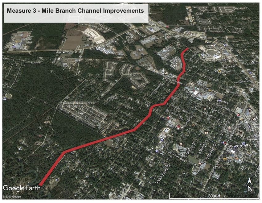
TSP Measure 3: Mile Branch Channel Improvements in Covington, LA.
Figure G:1-6 Mile Branch Channel Improvements
14St. Tammany Parish, Louisiana Feasibility Study
Appendix G – Real Estate Plan
The Mile Branch channel improvements would start at the intersection of Mile Branch and
US Highway 190, cross US Highway 190 Business, and would end at the intersection of Mile
Branch and the Tchefuncte River. This measure would consist of channel improvements on
the lower 2.15 miles (11,341 feet channel) of Mile Branch in Covington, LA.
The improvements would include clearing and grubbing and mechanical dredging of the
channel. The channel bottom would be lowered by 5 feet. Approximately 20 acres of channel
would be cleared and grubbed prior to mechanical dredging. An assumed maximum of
130,000 cubic yards of material may be mechanically dredged from the channel. The
preliminary design assumes an existing bank elevation of 1 foot, and a 10-feet bottom width.
The bank would be at 1V:3H slope. Material removed may include sediment, trees, debris,
or other obstructions within the waterway.
The Mile Branch channel improvements may include bridge replacements or culverts
(starting from north to south) at 29th, 28th, 25th, 23rd, 21st, 19th, and 18th Avenues. No
work is anticipated at the 15th and 11th Avenue channel crossings as those bridges were
replaced prior to this study (and the new bridges were designed to safely pass higher flows
on Mile Branch).
The necessary estates and acreages that would be acquired if the TSP is implemented are
discussed in Section 3 (Table G:3-1).
TSP Measure 4: Nonstructural Elevations and Flood Proofing
The TSP includes the implementation of nonstructural measures to reduce the risk of
damages from flooding to residential and non-residential structures that have first floor
elevations at or below the 50-year flood plain based on hydrological predictions. Structure
modification would be on a case-by-case basis across the 50-year floodplain.
Nonstructural measures differ from structural measures because they focus on reducing
consequences of flooding instead of focusing on reducing the probability of flooding. A total
of 8,498 structures are included in the nonstructural project measure. An estimated 6,643
residential homes In St. Tammany Parish, LA would be elevated to the future 100-year flood
stage up to 13 feet. In addition, 1,855 non-residential structures would be flood proofed up to
3 feet. The elevation and flood proofing of these structures addresses the structures in the
50-year flood plain that are not included in the areas benefitted from the structural features
of the TSP (Figure G:1-6).
15St. Tammany Parish, Louisiana Feasibility Study
Appendix G – Real Estate Plan
Figure G:1-7 Nonstructural Elevations/Flood Proofing
The Nonstructural Plan consists of these flood proofing measures:
• Elevation of eligible residential structures. Elevation of 6,643 structures to an
elevation no greater than 13 feet above grade. Elevation of the entire structure or
the habitable area of a structure would allow floodwaters to flow and recede
underneath.
• Floodproofing of eligible non-residential structures. Floodproofing 1,585 structures
up to 3 feet to reduce flood risk. Floodproofing would ensure that floodwaters
cannot get inside by making walls, doors, windows, and other openings
impermeable to water penetration up to three feet above grade.
The US Army Corps of Engineers (USACE), Mississippi Valley Division (MVD), and New
Orleans District (CEMVN) has prepared a Nonstructural Implementation Plan, which
provides details regarding a possible method of program implementation (refer to Appendix
H of the DIFR and EIS).
It is assumed that all properties have legal access by way of public streets or existing public
ROW. Further, it is assumed that residential and non-residential properties participating in
the project would have sufficiently large sites to accommodate staging of material and
equipment. For the purposes of this report, the assumption is that no further real estate
16St. Tammany Parish, Louisiana Feasibility Study
Appendix G – Real Estate Plan
rights need to be acquired for access to the properties or staging. Should additional ROW be
necessary, a standard Temporary Work Area Easement would be acquired. There are no
required borrow and disposal areas for the TSP nonstructural features.
Mitigation
A Mitigation Plan is currently being developed that may include purchasing mitigation bank
credits or construction of bottom land hardwood and marsh sites. During feasibility level
design, a Wetland Value Assessment will be performed in coordination with the U.S. Fish
and Wildlife Service to refine initial mitigation estimates. If USACE constructed mitigation
sites would be necessary, additional acres would be needed and acquired by Fee Estate,
Excluding Oil & Gas. The acreages needed for potential mitigation sites have not yet been
determined, and real estate costs for mitigation are not included in this draft REP. This
information will be addressed in the final IFR and EIS and the final REP.
17St. Tammany Parish, Louisiana Feasibility Study
Appendix G – Real Estate Plan
Non-Federal Sponsor
CPRAB is a state entity that is established, authorized, and empowered to carry out any and
all functions necessary to serve as the single entity responsible to act as the local sponsor
for construction, operation, and maintenance of the hurricane, storm damage reduction and
flood control projects in areas under its jurisdiction, including Greater New Orleans and
southeast Louisiana.
2.1 ASSESSMENT OF NON-FEDERAL SPONSOR CAPABILITY
An assessment of the legal and professional capability of the NFS, and its experience to
acquire and provide the LERRDs for construction, operation, and maintenance of the TSP
has been included as Attachment A to this REP. The NFS has worked with USACE on
numerous other projects and has been capable of performing the responsibilities of LERRDs
acquisition.
2.2 NON-FEDERAL SPONSOR RISK NOTIFICATION
During feasibility level design, the NFS will be notified in writing of the risks of acquiring
LERRD before the execution of a PPA. This letter will be attached to the final REP.
18St. Tammany Parish, Louisiana Feasibility Study
Appendix G – Real Estate Plan
Lands Required for the Project
3.1 LANDS, EASEMENTS, AND RIGHTS-OF-WAY (LER)
Measure 1: Federal Hurricane and Storm Risk Reduction Levee and Floodwall.
This alignment would impact approximately 67 private landowners. An estimated six
structure improvements would be impacted.
This Measure would require the temporary acquisition of an approximate total of 62 acres by
the NFS using USACE standard temporary easements estates for the construction of the
project, if it is implemented. This Measure would require the permanent acquisition of an
approximate total of 236 acres by the NFS using USACE standard estates for the
construction of the project, if it is implemented.
At the western portion of the proposed levee alignment, a portion of the proposed new
federal levee footprint lies within Big Branch Marsh National Wildlife Refuge (Figure G:4-2 in
Section 4). Refer to Section 4.3, Federally Owned Lands, for more information. The NFS
would acquire Authorization for Entry for construction of project features that are owned by
state, parish, or city governments. Table G:3-1 shows the privately owned LERRDs
acreages and estates required for the structural features of the TSP:
Table G:3-1. LER – Alignment for Measure 1
Project Feature Acres Estate
Measure 1 Levee/Floodwall 173 Perpetual Flood Protection Levee Easement
Measure 1 Flood Gates & Pump 63 Fee, Excluding Minerals
Stations
Measure1 Borrow 62 Temporary Work Area Easement (Borrow)
Improvements Fee, Excluding Minerals
Construction access and staging areas would be needed along the alignment for all
elements of TSP. However, access and staging areas required on privately owned lands
have not been identified for Measure 1. Additionally, potential borrow sites have been
identified, but a determination of exact locations has not been made. This information will be
refined during feasibility level design.
19St. Tammany Parish, Louisiana Feasibility Study
Appendix G – Real Estate Plan
Measure 2: Bayou Patassat Channel Improvements
The lands required for the implementation of this Measure are all assumed to be public
property and owned by either St. Tammany Parish or the city of Slidell, LA. Approximately 3
acres of ROW will be required if the TSP is constructed. If it is determined that privately
owned lands are required for the project, the standard Channel Improvement Easement or
Snagging and Clearing Easement may be acquired where needed.
Possible staging areas would include the city-owned land around the bayou and the Bayou
Vincent pump station or at the grassy area at the end of Bayou Lane. It is assumed that
access to the bayou would be via the city-owned property along the channel.
The existing ROW of the Bayou Patassat Channel is owned by St. Tammany Parish. The
parish would provide Authorization for Entry for construction to the NFS.
Measure 3: Mile Branch Channel Improvements
The existing ROW of the Mile Branch Channel is owned by St. Tammany Parish. The parish
would provide Authorization for Entry for construction to the NFS.
Specifically, approximately 20 acres of ROW would be required within the Mile Branch
Channel.
A temporary roadway may be required for access to the project, as well as temporary work
areas adjacent to the channel. This measure would require the temporary acquisition of an
approximate total of 34 acres by the NFS using USACE standard temporary easements
estates for construction of the project, if it is implemented. Approximately 41 private
landowners would be impacted.
The Table G:3-2 provides the privately owned LERRDs acreages and estates required for
construction of this project feature.
Table G:3-2. LER – Mile Branch Channel Improvement
Project Feature Acres Estate
Mile Branch – Access/Staging Areas 34 Temporary Work Area Easement; Temporary Road
Easement
Improvements Fee, Excluding Minerals
3.2 ESTATES TO BE ACQUIRED
The following standard estates would be acquired from private landowners. The use of non-
standard estates is not anticipated. Temporary estate duration would be 5 years.
20St. Tammany Parish, Louisiana Feasibility Study
Appendix G – Real Estate Plan
Road Easement (temporary [five years] and perpetual)
A (perpetual [exclusive] [non-exclusive] and assignable) (temporary) easement and
right-of-way in, on, over and across (the land described in Schedule A) (Tracts Nos. _____,
_____ and _____) for the location, construction, operation, maintenance, alteration
replacement of (a) road(s) and appurtenances thereto; together with the right to trim, cut, fell
and remove therefrom all trees, underbrush, obstructions and other vegetation, structures, or
obstacles within the limits of the right-of-way; (reserving; however, to the owners, their heirs
and assigns, the right to cross over or under the right-of-way as access to their adjoining
land at the locations indicated in Schedule B); subject, however, to existing easements for
public roads and highways, public utilities, railroads and pipelines.
Flood Protection Levee Easement (Perpetual)
A perpetual and assignable right and easement in (the land described in Schedule A) (Tracts
Nos. ___, ___ and ___) to construct, maintain, repair, operate, patrol and replace a flood
protection levee, floodwall, gate closure, including all appurtenances thereto; reserving,
however, to the owners, their heirs and assigns, all such rights and privileges in the land as
may be used without interfering with or abridging the rights and easement hereby acquired;
subject, however, to existing easements for public roads and highways, public utilities,
railroads and pipelines.
Temporary Work Area Easement (borrow) [five years]
A temporary easement and right-of-way in, on, over and across (the land described in
Schedule A) (Tracts Nos. _____, _____ and _____), for a period not to exceed __Five
years__________, beginning with date possession of the land is granted to the United
States, for use by the United States, its representatives, agents, and contractors as a borrow
area, including the right to borrow and/or deposit fill, spoil and waste material thereon and to
perform any other work necessary and incident to the construction of the St. Tammany
Parish, Louisiana Project, together with the right to trim, cut, fell and remove therefrom all
trees, underbrush, obstructions, and any other vegetation, structures, or obstacles within the
limits of the right-of-way; reserving, however, to the landowners, their heirs and assigns, all
such rights and privileges as may be used without interfering with or abridging the rights and
easement hereby acquired; subject, however, to existing easements for public roads and
highways, public utilities, railroads and pipelines.
Temporary Work Area Easement (staging) [five years]
A temporary easement and right-of-way in, on, over and across (the land described in
Schedule A) (Tracts Nos. _____, _____ and _____), for a period not to exceed __Five
years_________, beginning with date possession of the land is granted to the United States,
for use by the United States, its representatives, agents, and contractors as a work area,
including the right to move, store and remove equipment and supplies, and erect and
remove temporary structures on the land and to perform any other work necessary and
21St. Tammany Parish, Louisiana Feasibility Study
Appendix G – Real Estate Plan
incident to the construction of the St. Tammany Parish, Louisiana Project, together with
the right to trim, cut, fell and remove therefrom all trees, underbrush, obstructions, and any
other vegetation, structures, or obstacles within the limits of the right-of-way; reserving,
however, to the landowners, their heirs and assigns, all such rights and privileges as may be
used without interfering with or abridging the rights and easement hereby acquired; subject,
however, to existing easements for public roads and highways, public utilities, railroads and
pipelines.
Fee Excluding Minerals (With Restriction on Use of the Surface)
The fee simple title to the land, subject, however, to existing easements for public roads and
highways, public utilities, railroads and pipelines; excepting and excluding all oil and gas in
and under said land and all appurtenant rights for the exploration, development, production
and removal of said oil and gas, but without the right to enter upon or over the surface of
said land for the purpose of exploration, development, production and removal therefrom
said oil and gas.
Channel Improvement Easement
A perpetual and assignable right and easement to construct, operate, and maintain channel
improvement works on, over and across (the land described in Schedule A) (Tracts Nos.
_____, _____ and _____) for the purposes as authorized by the Act of Congress
approved_______________, including the right to clear, cut, fell, remove and dispose of any
and all timber, trees, underbrush, buildings, improvements and/or other obstructions
therefrom; to excavate: dredge, cut away, and remove any or all of said land and to place
thereon dredge or spoil material; and for such other purposes as may be required in
connection with said work of improvement; reserving, however, to the owners, their heirs
and assigns, all such rights and privileges as may be used without interfering with or
abridging the rights and easement hereby acquired; subject, however, to existing easements
far public roads and highways, public utilities, railroads and pipelines.
Snagging And Clearing Easement
A perpetual and assignable right and easement on, over and across (the land described in
Schedule A)(Tract(s) No(s). ____, ____ and ____,) for the purposes of occasionally
conducting snagging and clearing operations along the banks of the
_______________________, including the right to trim, cut, fell, remove and dispose of any
and all trees, brush, obstacles or other vegetation, except trees having a diameter-
exceeding 8 inches measured at _______ height; reserving, however, to the landowners,
their heirs and assigns all such rights and privileges as may be used without interfering with
or abridging the rights and easement hereby acquired; subject, however, to existing
easements for public roads and highways, public utilities, railroads and pipelines.
22St. Tammany Parish, Louisiana Feasibility Study
Appendix G – Real Estate Plan
3.3 NON-STANDARD ESTATE – NONSTRUCTURAL PROJECT FEATURE
For properties that are eligible for elevation or flood proofing, an agreement would be
executed between the NFS and the landowner, which would serve as right-of-entry for the
NFS and the U.S. for construction, inspection and OMRR&R of the project. The agreement,
as well as any required curative documents, subordination or release agreement(s), shall be
recorded by the NFS in the public records of the parish in which the property is located prior
to commencement of the nonstructural improvements on the property.
The Flood Proofing Agreement would authorize USACE, the NFS, or their contractors to
enter the property for purposes of implementing the flood proofing action and for inspection
and enforcement purposes, and would include the agreement of the property owners to hold
harmless the NFS and USACE for any damages arising from the flood proofing work, and a
covenant running with the land shall be executed by all owners of the property.
Elevation and flood proofing of eligible structures would require that the NFS acquire an
easement as a part of the agreement, which runs with the land, and prohibits conversion or
occupancy of any part of the structure located below the lowest habitable finished floor for
human habitation and prohibits the alteration of the structure in any way to impede the
movement of flood waters under the structure. The easement language included would also
prohibit the construction of any other structure in a manner that would impede the movement
of floodwaters under the structure. The draft easement language will be submitted through
CEMVD to CEHQ-RE as a request for approval of a Non-Standard Estate.
3.4 FACILITY/UTILITY RELOCATIONS
There is one natural gas pipeline, owned by ExxonMobil, located within the levee footprint,
which would be relocated via Up-and-Over Pipeline relocation during construction. There is
one transmission line owned by CLE which would not be relocated, but would be de-
energized during construction. The total estimated cost of facility/utility relocations is
$887,000.
Any conclusion or categorization contained in this report that an item is a utility or facility
relocation to be performed by the NFS as part of its LERRD responsibilities is preliminary
only. The government will make a final determination of the relocations necessary for the
construction, operation and maintenance of the project after further analysis and completion
and approval of a Final Attorney’s Opinion of Compensability for each of the impacted
utilities and facilities.
23St. Tammany Parish, Louisiana Feasibility Study
Appendix G – Real Estate Plan
Federal Lands
4.1 EXISTING FEDERAL PROJECTS
There are numerous Federal projects located within the study area.
USACE Southeast Louisiana Urban Flood Control Project
Seven projects were authorized under USACE’s Southeast Louisiana Urban Flood Control
Project (SELA) program in St. Tammany Parish in 1996, pending a study (known as a 533d
report) to confirm they are technically sound, environmentally acceptable and economically
justifiable, and include: Schneider Canal Hurricane Protection; Mandeville Hurricane
Protection; Lacombe Area Plan; Abita Area Plan; Mile Branch Plan; Bayou Chinchuba Plan;
and Slidell Area Plan (W‐13, W‐14, and W‐15 Canals). Figure G:4-1 shows these seven
projects within St. Tammany Parish.
Figure G:4-1. Southeast Louisiana (SELA) Projects
Only the W-14 project in Slidell has an approved report from March 2012 confirming it is
technically sound, environmentally acceptable, and economically justifiable (533d report).
24St. Tammany Parish, Louisiana Feasibility Study
Appendix G – Real Estate Plan
Because the W-14 project had an approved 533d report it was excluded from plan
formulation under this study. Analysis of the other six projects were included as part of plan
formulation because the original SELA projects were over 30 years old and it was expected
that conditions in the study area might have changed.
After this study initiated, efforts to begin to prepare a 533d report for the Schneider Canal
project were subsequently funded. There is overlap in the study area for this project with the
smaller authorized study area for the SELA Schneider Canal project. This study will continue
to evaluate a comprehensive plan for the parish; however, the SELA Schneider Canal
Hurricane Projection project is more limited in scope and project area and is evaluating the
recommended alignment included in the authorizing language. Coordination between the
project teams, Office of Counsel, and leadership is ongoing and will continue to determine
the linkages between the two studies.
4.2 FEDERALLY OWNED LANDS
The United States owns fee title to lands within the Big Branch Marsh National Wildlife
Refuge, located on the western reach of the levee alignment for Measure 1 (Figure G:4-2).
The U.S. Fish and Wildlife Service (USFWS) is the managing agency for the lands. The NFS
would acquire from the USFWS the necessary real estate interests required for the project.
Figure G:4-2. Big Branch Marsh NWR – Alt 6c Levee Alignment
25St. Tammany Parish, Louisiana Feasibility Study
Appendix G – Real Estate Plan
4.3 NAVIGATION SERVITUDE
The federal navigation servitude is the dominant right of the Federal Government under the
Commerce Clause of the U.S. Constitution to use, control, and regulate the navigable waters
of the United States and submerged lands thereunder for various commerce-related
purposes including navigation and flood control. In tidal areas, the servitude extends to all
lands below the mean high water mark. In non-tidal areas, the servitude extends to all lands
within the bed and banks of a navigable stream that lie below the ordinary high water mark.
The federal navigation servitude is not available in the implementation of the TSP.
26St. Tammany Parish, Louisiana Feasibility Study
Appendix G – Real Estate Plan
Induced Flooding
Based on the ADCIRC modeling of other systems, it was estimated that it may be possible
to see increases of 1-3 feet in the 1 percent AEP water level on the floodside of the
measures in the TSP. The proposed structural measures of the TSP are not expected to
cause significant changes to storm surge levels for the Lake Pontchartrain and Vicinity
system in the Greater New Orleans Hurricane & Storm Damage Risk Reduction System
(HSDRRS) nor to the West Shore Lake Pontchartrain system.
The potential for induced flooding will be further investigated during feasibility-level design. If
the induced flooding is confirmed, the TSP would be refined to appropriately address the
issue which could include things as additional nonstructural actions or refinement of TSP
measures.
If it is determined that structures outside of the proposed levee and floodwall alignment are
impacted, a Takings Analysis would be prepared to assess the impacts and a plan would be
developed to mitigate the potential impacts.
27St. Tammany Parish, Louisiana Feasibility Study
Appendix G – Real Estate Plan
Uniform Relocations Assistance (P.L. 91-
646, Title II as Amended)
The availability of relocation assistance benefits for persons within the structural and
nonstructural features of the TSP would be determined pursuant to the Uniform Relocation
Assistance and Real Property Acquisition Policies Act of 1970, as amended (“Uniform Act”),
and its implementing regulations at 49 C.F.R. Part 24 (“Uniform Relocation Assistance and
Real Property Acquisition for Federal and Federally-Assisted Programs”). Approximately 10
residential and non-residential structures are located within the footprint of the structural
features. Approximately 6,643 residential and 1,585 non-residential structures are located
within the nonstructural feature of the TSP. Because the nonstructural plan is voluntary in
nature, Uniform Act assistance for nonstructural measures would be provided only to
tenants. The estimated costs for the relocation assistance benefits are included in Section 8,
Real Estate Costs.
28St. Tammany Parish, Louisiana Feasibility Study
Appendix G – Real Estate Plan
Other Impacts to Lands Required for the
Project
7.1 TIMBER/MINERALS/ROW CROP ACTIVITY
The Louisiana Department of Natural Resources provides a Strategic Online Natural
Resources Information System (SONRIS), which contains up-to-date information on oil and
gas activity in the state of Louisiana. A review of the information maintained by SONRIS
indicates that although there are oil and gas wells within the study area, there are no wells
located within the footprint of the TSP. Furthermore, there are no crops or merchantable
timber affected by the TSP.
7.2 OYSTER LEASES
A review of SONRIS by Louisiana Department of Natural Resources indicates there are no
oyster leases within the TSP project area. As such, no oyster leases would be acquired as a
result of this project.
7.3 HAZARDOUS, TOXIC, AND RADIOACTIVE WASTE
An abridged Phase I Environmental Site Assessment was conducted to assess the potential
for Hazardous, Toxic, and Radioactive Waste (HTRW) materials within the proposed TSP
footprints for each of the Measures. As a result of this investigation, it was determined that
the probability of encountering HTRW during construction would be low. It was
recommended that a Full Phase I ESA be conducted prior to construction. However, it is not
anticipated that there would be impacts to the real estate acquisition process and the LER
value estimate due to known or suspected presence of contaminants within the LER
required for project construction. Further discussion of these environmental investigations
and findings can be found in Section 3.2.1.7 of the DIFR and DEIS.
7.4 ZONING IN LIEU OF ACQUISITION
There would be no application or enactment of zoning ordinances in lieu of, or to facilitate,
acquisition of real estate interests in connection the structural features, or implementation of
the nonstructural features. The nonstructural measures are voluntary in nature and would be
available only to existing eligible structures as defined within the TSP. During PED, planning
and zoning regulations would be further reviewed and discussions would be conducted with
the NFS regarding the development and adoption of land use regulations for future activities
within the project area. The NFS would be required to coordinate these matters with local
planning commissions.
29St. Tammany Parish, Louisiana Feasibility Study
Appendix G – Real Estate Plan
Real Estate Costs
8.1 REAL ESTATE COSTS – STRUCTURAL PROJECT FEATURES
The Cost Estimate provided in Table G:8-1 are for the estimated LERRDs required for
construction, operation, and maintenance, for all of the TSP measures. This estimate also
includes lands and administrative costs for borrow acquisition. This estimate does not
include estimated cost of acquisition of lands for staging, access, or mitigation for Measure
1. This information will be refined during feasibility level design.
Table G:8-1. Estimated Real Estate Costs for the TSP - Structural
01 Real Estate Total $15,968,660
02 Facility & Utility Relocations Total $887,000
This Rough Order of Magnitude cost estimate is restricted use and not intended to comply
with Uniform Standards of Professional Appraisal Practice (USPAP). Inspection of the
property was made by aerial photography and appraiser utilized online information from local
assessor offices. Property values were determined based on comparable sales and listings
on file at the time of this report, as well as discussions with active market participants.
8.2 REAL ESTATE COST – NONSTRUCTURAL PROJECT FEATURES
Rough Order of Magnitude level cost estimates were prepared based on the assumption that
there are a total of 8,498 structures to be included within the plan (6,643 residential
elevations, 1,855 non-residential flood proofing. Real estate costs for the TSP include
administrative costs for the execution of the agreement between the NFS and the
landowner, administrative costs associated with the elevation of residential structures and
flood proofing of non-residential structures, and relocation assistance costs for tenants.
Some associated administrative requirements would be for obtaining right-of-entry, title
research, execution of Flood Proofing Agreements and curative documents, filing of the
servitude running with the land, and coordination and oversight of relocations. Costs of
elevating and flood proofing the structures are construction costs, and are not included as
real estate costs. Table G:8-2 shows the estimated real estate costs for the nonstructural
TSP measures:
30St. Tammany Parish, Louisiana Feasibility Study
Appendix G – Real Estate Plan
Table G:8-2. Estimated Real Estate Costs for the TSP - Nonstructural
NON-
RESIDENTIAL RESIDENTIAL
TOTAL
ELEVATIONS FLOOD
PROOFING
ESTIMATED # OF STRUCTURES 6,643 1,855 8,498
TOTAL REAL ESTATE COSTS $139,436,253 $35,895,787 $175,332,040
These cost estimates are subject to revision during feasibility level design.
31St. Tammany Parish, Louisiana Feasibility Study
Appendix G – Real Estate Plan
Real Estate Acquisition Schedule
9.1 REAL ESTATE SCHEDULE – STRUCTURAL PROJECT FEATURES
The following acquisition schedule is based on the premise that the structural features of the
project would impact approximately 67 private landowner(s). A detailed acquisition schedule
will be prepared once the 95 percent plans and specifications for the project are prepared.
The schedule below provides the total amount of time to complete the acquisition of real
estate rights for the construction of the project based on the information available at this
time. This schedule is only for purposes of the feasibility study.
TOD, Mapping 2 months
Obtain Title & Appraisals 6 months
Negotiations 18 months
Closing 6 months
Eminent Domain Proceedings (if needed) 12 months
9.2 REAL ESTATE SCHEDULE – NONSTRUCTURAL PROJECT FEATURES
The nonstructural project elevations and flood proofing features would require execution of
an agreement between the landowner and the NFS. In addition, the following administrative
functions, among others, would be required: title research, HTRW analysis, and structural
condition analysis, and additional property inspections to determine eligibility. Temporary
rights of entry would have to be obtained from the owners in order to perform some of these
administrative duties. (Refer to Appendix H of the DIFR and EIS for more detailed discussion
of the non-structural implementation plan.)
Tasks shown below would likely vary by property; therefore, the schedule shown is the
overall anticipated time for the total number of structures and assumes an overlap of tasks.
The schedule is dependent upon a defined nonstructural implementation plan and assumes
that project funding would be available every year. Therefore, this estimated schedule is
expected to be refined as more information becomes available during PED and
implementation of the TSP.
Obtain Right-of-Entry for Investigations (To Determine Eligibility) 6-12 months
Title research 40-60 months
Preliminary Investigations (i.e. HTRW, structural, surveys, etc.) 36-60 months
Execution of agreement between landowner/NFS & curative
documents for elevations or non-residential flood proofing 12-24 months
Filing Agreement between landowner and NFS 12 months
Relocation of Displaced Tenants 12-24 months
32You can also read