Steven Stancel - City of Sarasota March 15, 2010
←
→
Page content transcription
If your browser does not render page correctly, please read the page content below
Steven Stancel – City of Sarasota
Jason Collins, Ph.D., P.E., AICP – Trans Associates, Inc.
                                                            March 15, 2010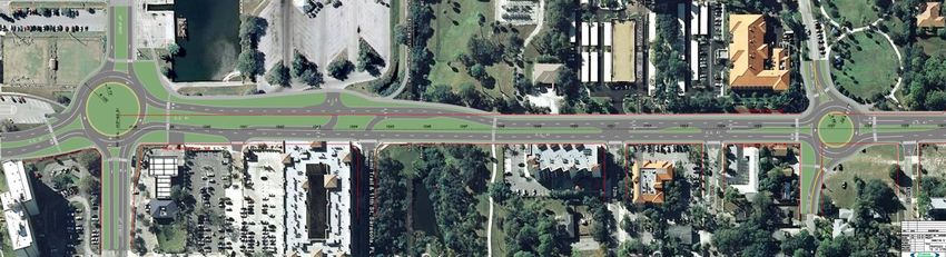
PRESENTATION OUTLINE

• Review Goals & Objectives

• History of Events

• Outline of Improvements

• Additional Info Requested by Commission and FDOT

• Funding Plan
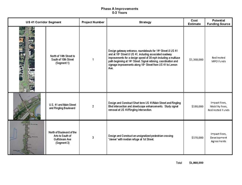
PROJECT OBJECTIVES
“Develop measures that reconnect the Downtown to the Bayfront
using the most effective and efficient means with an emphasis on
pedestrian comfort. This goal requires changing the current
relatively high-speed, pedestrian-unfriendly character of US 41.”

“Efforts are focused toward developing an action plan that guides the
design and construction process of improvements, which will utilize
progressive concepts including, but not limited to, Complete Street
Design, Context Sensitive Design, and those related to New
Urbanism.”

“Improvement measures shall be phased as short-term (0 – 3 years)
as well as long-term measures (3+ years).”
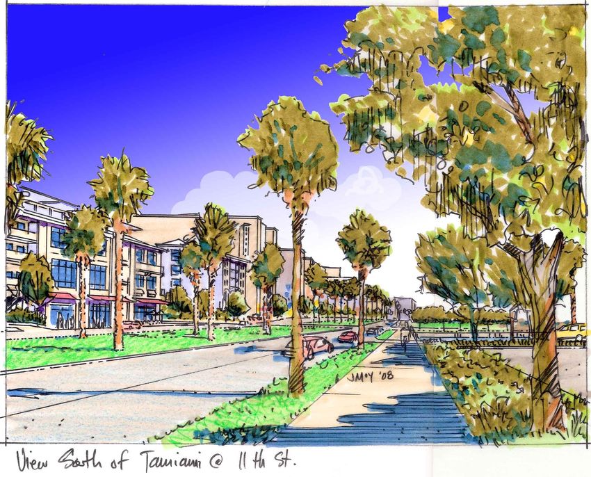
TAMIAMI TRAIL (US 41)

US 41 along Main Street

                                        US 41 “Bypass” circa 1960s
DOWNTOWN MASTER PLAN 2020

           “Connecting Downtown to the Bayfront”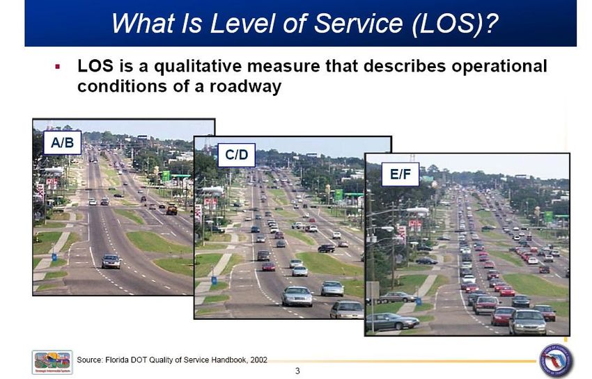
US 41 REMAINS UNCHANGED

                Current Pedestrian Signal for
                            crossing US 41.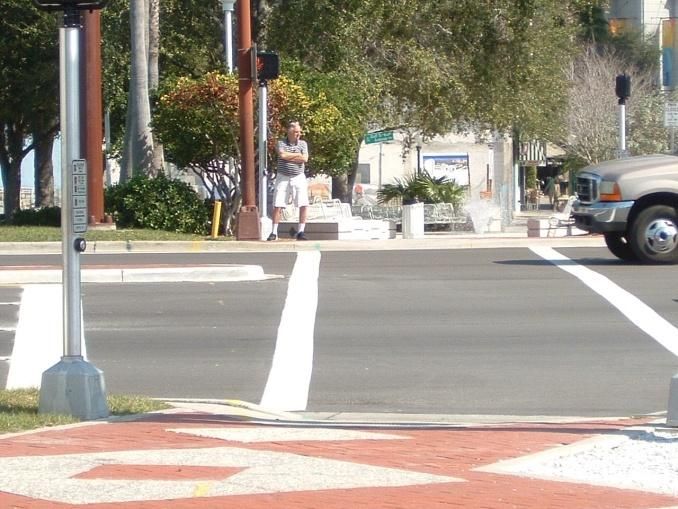
History of Project Milestones

• Technical Research
• Five Day Public Charrette
• Development of Recommendations
• Debated Topics and Compromises
• Commission Workshop
• FDOT Review and Coordination
PUBLIC INVOLVEMENT

Site Visits                           Saturday Workshop

              Kick-Off Presentation
Outline of Improvements
Key Concepts
• Reduce design speed to
  30 mph
• Roundabouts
• Create urban avenue with
  wide median
• Create Complete Streets –
  space for all modes
DEBATED TOPICS SINCE
                 THE CHARRETTE
•   Gulfstream Ave connection
•   Roundabouts
•   Cocoanut Ave extension
•   Waterfront parking lot
•   Orange Ave cut-through traffic
•   14th Street
PROJECT RECOMMENDATIONS Compromises Provided • Maintain US 41 designation • Keep 4 lanes • Preserve existing function • No on-street parking
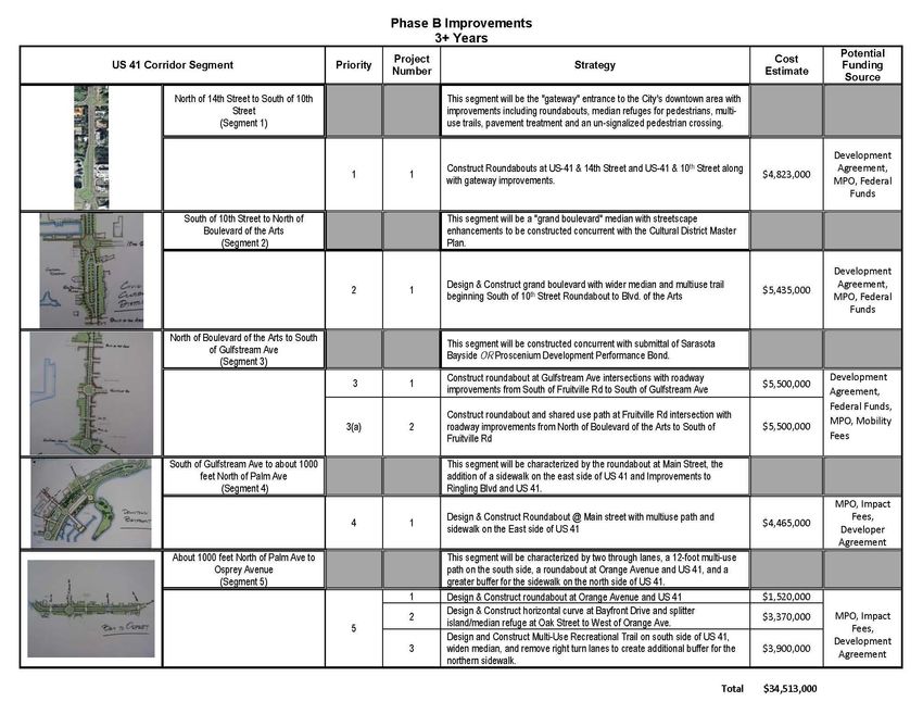
Additional Info Since Workshop

• Traffic Operations Comparison
• Cost Comparison of “Traditional”
  Improvement Types and Maintenance
• Preliminary Design between 10th Street
  and 14th Street
• Further FDOT Review Coordination
Traffic Operations Comparison
Average Vehicle Delay
Design Year
Average Delay
Intersection (sec/vehicle)
Existing Delay
Roundabout
Geometries Reduction
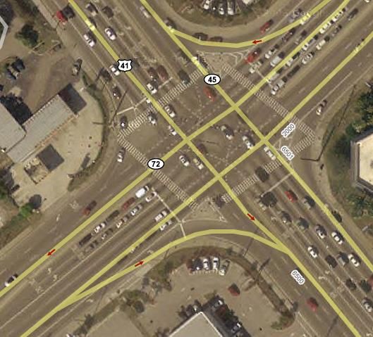
US-41 & 14th Street 45.3* 8.4 82%
US-41 & 10th Street 53.9 41.1 24%
Total Study Area 437.0 234.0 47%
* Denotes existing two-way stop control condition.Traffic Operations Comparison
Vehicle Emissions
Design Year
CO2 Emissions
Intersection (grams)
Existing Emission
Roundabout
Geometries Reduction
US-41 & 14th Street 4,905.4* 2,994.5 39%
US-41 & 10th Street 6,260.7 5,757.9 8%
Total Study Area 70,656.0 33,595.0 53%
* Denotes existing two-way stop control condition.Traffic Operations Comparison
PM Peak Hour Fuel Consumption
Design Year 2021
PM Peak Hour Fuel Consumption
Intersection (gallons)
Existing Fuel
Roundabout
Geometries Reduction
US-41 & 14th Street 72.3* 42.8 41%
US-41 & 10th Street 89.0 82.4 7%
Total Study Area 1,009.0 481.0 52%
* Denotes existing two-way stop control condition.Traditional Signal Improvements
Cost Comparison
                              Signal Cost     Roundabout
                             Improvements        Cost

       14th Street to 10th    $4.7 million    $4.2 million
             Street

       Remaining Study
                              $17.0 million   $15.8 million
            Area

“Doing Nothing” will still cost $7+ million for maintenance.
Roundabouts • Improve aesthetics • Reduce crash severity • Reduce noise pollution • Improve traffic efficiency • Independent of electronics • Visibility between drivers and pedestrians
QUICK IMPROVEMENTS
Main Street and Ringling Boulevard
•   Textured Pavement
•   Additional Wayfinding Signage
•   Shading
•   Crosswalk Lighting
•   Better median refuge area for pedestrians

Still requires FDOT approval.
Preliminary Design
  10th Street to 14th Street
24
25
SUMMARY
• US 41 corridor serves many purposes for
  different people

• Location of project captures public interest

• Need for modernizing infrastructure with
  land use changes

• Recommendations consistent with
  objectives
SUMMARY
• Keeping with previously approved concepts

• Skepticism is expected

• Compromise established

• Available funding

• Impacts of doing nothing
MILESTONES
• Project Approval from Commission
• Initiate permitting efforts
  – Detailed design
  – Florida DOT and Federal Highway
    Administration

• Modernize City’s transportation policies
  – Focus on funding policies
Citywide Mobility Why are we having this discussion?
Citywide Mobility How do we measure traffic? The measurement we now have for evaluating traffic is the FDOT/Highway Capacity Manual determination of Level of Service for the PM peak. What does Level of Service mean in this context and who are we serving?
Citywide Mobility
FDOT LOS
More balanced – going from this

 One Example of a short fall of our existing system –
What improvements are required now?

         Street                 To            From     Miles          Estimated Cost

 12th Street       US 301            East Ave           1.028409           $7,479,856.88

 17th Street       US 301            East Ave           0.126894             $922,928.93

 Bay Road          Osprey Ave        US 41              0.195076           $1,418,831.05

 Bee Ridge Rd      US 41             School Ave                0.25        $1,818,307.75

 Cocoanut Ave      2nd Street        Fruitville Road    0.051136             $371,926.59

 Fruitville Road   Links Ave         US 301             0.124242             $903,643.85

 Fruitville Road   Shade Ave         Tuttle Ave           0.50625          $3,682,073.19

Total cost for addressing LOS F currently with roadway/intersection
improvements is over $70 Million dollars
Senate Bill 360
This Bill requires the City to developed an
updated Transportation plan that is more
multi-modal.
It requires a financially feasible CIP.
It includes a study on a mobility fee.SB 360 Multi-modal requirements
(5)(b)4. A local government that has a transportation concurrency exception
area designated shall, within 2 years after the designated area becomes
exempt, adopt into its local comprehensive plan land use and
transportation strategies to support and fund mobility within the
exception area, including alternative modes of transportation.
If the state land planning agency finds insufficient cause for the failure to
adopt into its comprehensive plan land use and transportation strategies to
support and fund mobility within the designated exception area after 2 years, it
shall submit the finding to the Administration Commission, which may impose
any of the sanctions set forth in s. 163.3184(11)(a) and (b) against the local
government.Senate Bill 360 - Definition of
Financial Feasibility
Subsection 163.3177(3)(b)1, F.S.,
• The capital improvements element must be reviewed on an
annual basis and modified as necessary in order to maintain
a financially feasible 5-year schedule of capital
improvements.
• The annual update to the capital improvements element of
the comprehensive plan need not comply with the financial
feasibility requirement until December 1, 2011.Senate Bill 360 - Definition of Financial
Feasibility
Subsection 163.3164 (32)
• "Financial feasibility" means that sufficient revenues are
currently available or will be available from committed funding
sources for the first 3 years, or will be available from committed
or planned funding sources for years 4 and 5, of a 5-year capital
improvement schedule for financing capital improvements.
• A comprehensive plan shall be deemed financially feasible for
transportation and school facilities throughout the planning period
addressed by the capital improvements schedule if it can be
demonstrated that the level-of-service standards will be achieved
and maintained by the end of the planning period even if in a
particular year such improvements are not concurrent as required
by s.163.3180.Citywide Mobility
o We have started with the existing objectives
Obj 1 – Level of Service for safe, convenient, and effective multi-
modal transportation system.
Obj 2 – Roadway Design and Construction for Safe, Convenient and
Efficient Multi-modal Transportation System.
Obj 3 – Multi-modal Transportation.
Obj 6 – Transportation System to Enhance and Preserve
Neighborhoods.
Obj 7 – Increased Use, Safety and Convenience of Pedestrians and
Bicycle Networks.To a more balance plan –
Citywide Mobility
The steps are:
1) Approval from Commission to begin the process.
2) Development of inventory and data of our existing system.
3) Undertake a public education and input process to get direction on:
   *development of a system of measurement that is more multi-modal
   and sustainable.
   *a fee for users of the system that is more equitable, provides for the
   ability to fund projects other than just road widening and allows for
   directed growth and neighborhood preservation.
   *develop so policies for consideration that would implement the plan
   and meet the objectives as developed.
4) Presentation the City Commission for review of data and public input
   and direction on policy development.
Thank You
You can also read