Sudden-Onset
Hazards and the Risk
of Future Displacement
in Vanuatu
←
→
Page content transcription
If your browser does not render page correctly, please read the page content below
Sudden-Onset Hazards and the Risk of Future Displacement in Vanuatu
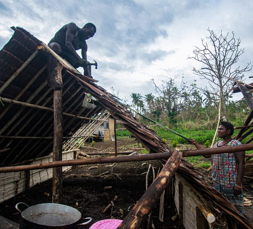
Families building a new kitchen beside the damaged
house. Vunavose, South Santo, Vanuatu, April 2020,
© UNICEF/UNI324720/Shing
Table of Contents
Summary 4
Background information 6
Disaster displacement in Vanuatu: historical trends (2008-2020) 9
Displacement risk: two key metrics and how to read them 13
Disaster displacement risk in Vanuatu 13
Probable Maximum Displacement (PMD) by hazard 14
Average Annual Displacement (AAD) per hazard and multi-hazards 14
Results: displacement risk by hazard 15
Risk of displacement as a result of storm surges 16
Risk of displacement as a result of cyclonic winds 17
Risk of displacement as a result of earthquakes 18
Risk of displacement as a result of tsunamis 19
Toward risk-informed decision making 20
Why do we need to understand risks? 20
Methodological considerations and caveats 22
IDMC’s global disaster displacement risk model 22
Caveats and future improvements 23
Endnotes25
Acknowledgement:27
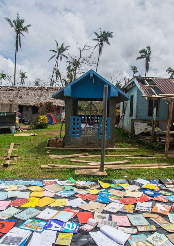
Cover image: Drying up school books that got wet during the cyclone. April 2020, © UNICEF/UNI324740/Shing
Summary

Disaster displacement is one of the world’s biggest               time period, and determines outlier events that
humanitarian and sustainable development challenges,              could occur during it.
and climate change and urbanisation serve to aggravate     •      Average Annual Displacement (AAD) is a compact
the phenomenon.                                                   metric that represents the annualised accumulated
                                                                  effect of small to medium and extreme events and
IDMC has built upon the risk analysis developed by                predicts the likely displacement associated with
the United Nations Office for Disaster Risk Reduction             them on a yearly basis.
to look at future displacement risk associated with
sudden-onset hazards such as earthquakes, tsunamis,        Storm surge represent Vanuatu’s highest displacement
cyclonic winds and storm surges. The analysis consid-      risk. There is a 64 per cent probability that one will
ered a wide range of hazard scenarios, their likelihood    displace 10,900 people in the next 50 years. This is the
and their potential to cause housing damage, which         country’s PMD.
serves as a proxy for displacement. At this stage, our
model’s current resolution, however, did not enable        Sudden-onset hazards such as earthquakes, tsunamis,
us to assess the risk associated with riverine floods in   cyclones and storm surges are likely to displace an av-
small island states.                                       erage of around 3,680 people during any given future
                                                           year. This is the archipelago’s AAD.
This technical paper presents the initial results of our
efforts to assess the risk of displacement associated      Displacement risk is determined by three factors:
with disasters and climate change in Vanuatu. It also
recognises that relocation is an appropriate long-term     1. Hazard: the likelihood of different hazards and
adaptation strategy.                                          their intensity
                                                           2. Exposure: the number of people and assets ex-
It examines risk levels and uncertainties for sudden-on-      posed to hazards
set hazards by type to produce a baseline country risk     3. Vulnerability: the likelihood of exposed houses and
profile via two national-level metrics:                       buildings being damaged or destroyed

•   Probable Maximum Displacement (PMD) is the             Our global disaster displacement risk model does not
    maximum displacement expected within a given           consider people’s economic and social vulnerability.

                                                                Sudden-Onset Hazards and the Risk of Future Displacement in Vanuatu   4
                                                                                                                           Summary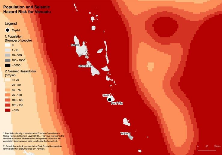
It covers only the physical aspect by looking at the extent                               What are disaster displacement and
    of damage and destruction that hazards of different                                       its associated risk?
    intensities are likely to cause.
                                                                                                  Disaster displacement refers to “situations
    The results it generates provide insight into future                                      where people are forced to leave their homes
    disaster scenarios, informing decision-makers in their                                        or places of habitual residence as a result of a
    efforts to reduce the risk of displacement and with it                                        disaster or in order to avoid the impact of an
    the number of people forced to flee their homes when                                      immediate and foreseeable natural hazard. Such
    hazards strike.                                                                               displacement results from the fact that affected
                                                                                                  persons are (i) exposed to (ii) a natural hazard
    The inhabitants of small island developing states in the                                  in a situation where (iii) they are too vulnerable
    Pacific are among the world’s most exposed to disas-                                      and lack the resilience to withstand the impacts
    ters relative to population size. At least 50,000 are                                         of that hazard”.1
    at risk of being displaced each year. Almost all human
    settlements, major services and tourism infrastructure                                        Disaster risk refers to “the potential loss of life,
    are located in coastal areas, and sudden-onset hazards                                    injury, or destroyed or damaged assets which
    such as cyclones and flooding pose severe social and                                          could occur to a system, society or a community
    economic risks.                                                                           in a specific period of time, determined prob-
                                                                                              abilistically as a function of hazard, exposure,
    This report is divided into four main parts:                                              vulnerability and capacity”. 2

    1.   Background information on Vanuatu
    2.   A baseline for disaster displacement risk in the
         country
    3.   Moves toward risk-informed decision-making
    4.   Information on how our risk model was constructed,
         caveats and future improvements

    Figure 1: Displacement risk: How is it estimated?

                                                                                                                                    Probability of
                                                                                                                                    being destroyed
                                                                                                                                    Probability of

                                 =                           X                                X                                     being damaged
                                                                                                                                    Probability of not
                                                                                                                                    being affected
    Displacement risk                     Hazard                          Exposure                     Vulnerability
                                          Phenomenon that may             People and buildings         How different buildings react
                                          cause displacement              in hazard-prone areas        to different hazard intensities
                                          (e.g. Earthquake)

5   Sudden-Onset Hazards and the Risk of Future Displacement in Vanuatu
    Summary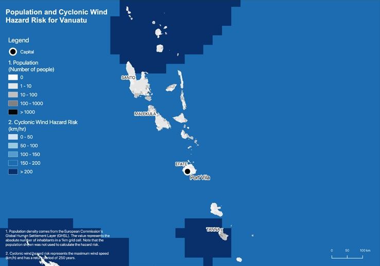
Background
        information
                                                              up around ten per cent of Vanuatu’s gross domestic
                                                              product (GDP).6 The GDP per capita is around $3,115.
                                                              Vanuatu is among the last places in the world where
                                                              the subsistence economy or “traditional economy”
                                                              still outweighs the cash economy in terms of providing
                                                              livelihoods for the population.7

                                                              Some agricultural crops are already showing signs of
                                                              stress under current climatic conditions. Water- scarce
                                                              areas and small islands that depend entirely on rainwater
                                                              and underground water sources are also experiencing se-
                                                              vere water shortages. Coastal erosion and flooding affect
                                                              coastal communities, and fish poisoning has emerged as a
                                                              danger in recent years. These problems will be aggravat-
Map 1: Vanuatu location map                                   ed by any further changes in climatic conditions.8

Located to the north-east of Australia, to the north of       The tropical oceanic climate has two different seasons: a
New Zealand, and between New Caledonia and Fiji,              wet, hot season which runs from November to April and
Vanuatu is a remote archipelago nation, consisting of         a dry, colder one that runs from May to October.9 Vanua-
a chain of 82 volcanic islands, including 13 principal        tu’s latitude places it in the path of tropical cyclones, and
islands, extending 850km from north to south.3 Many           it is subject to cycles of El Niño/La Niña-Southern Oscil-
of those islands sit just 0.9 metres (three feet) above       lation (ENSO), which respectively, increase the risks of
sea level.4 Home to almost 300,000 residents, Vanuatu         droughts and floods, and make rainfall highly variable
concentrates a large share of its population, or about        from year to year, with either very dry or very wet
36 per cent, in the capital, Port Vila, in Shefa province.5   conditions.10 Along with extreme events like cyclones,
                                                              these conditions can significantly affect water quality,
The economy is based primarily on the exploitation of         food security, infrastructure, livelihoods and health.11
natural resources such as copra, beef, timber, kava and
coconut oil. About 80 per cent of the population works        Climate change is expected to affect the country’s coast-
in subsistence or small-scale agriculture, which makes        al resources through increased ocean acidification, sea

                                                                 Sudden-Onset Hazards and the Risk of Future Displacement in Vanuatu   6
                                                                                                              Background information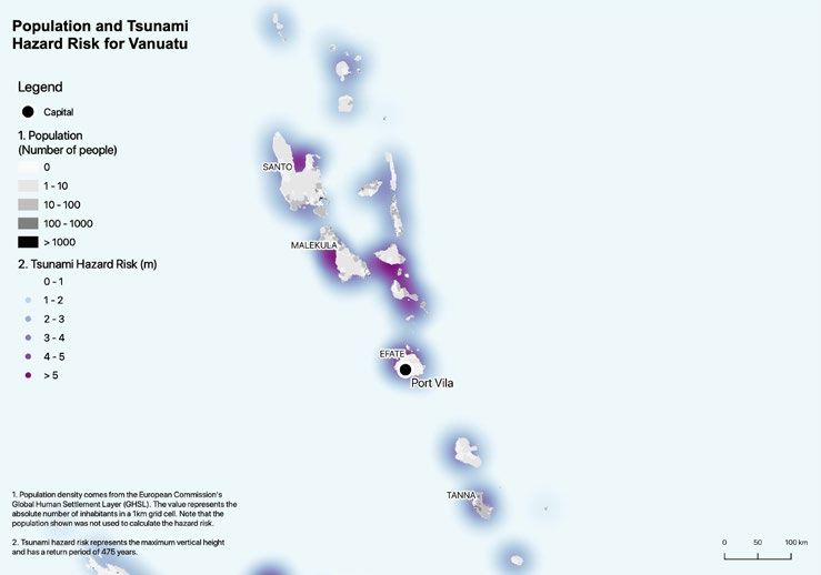
level rise and coral bleaching.12 The sea level has risen             slightly reduced growth rate during the past decade.
    by an average of six millimetres a year since 1993.13                 This trend is believed to stem, at least in part, from
    Vanuatu is the country with the highest disaster risk                 economic effects following the global financial crises
    according to the World Risk Report.14                                 of 2008. 20

    As in many small island developing states, exposure to                Many Pacific cities have expanded in recent years with
    hazards in Vanuatu is driven by the growing concen-                   the establishment of informal settlements on riverbanks
    tration of people and assets in urban, low-lying coastal              and estuaries, and in peri-urban areas, waste disposal
    areas. Disasters affect ever more people in these are-                sites and mangrove swamps. These factors drive up the
    as, inflicting increasing harm in terms of employment,                risk and potential impacts of disaster displacement.21
    housing, and critical infrastructure, such as roads, power
    and water supplies.15                                                 Rapid urbanisation in Port Vila has resulted in high
                                                                          population density in exposed and vulnerable areas of
    More than 94 per cent of the population live in coastal               the city. The peri-urban areas of the city are growing
    areas where the vast majority of services, infrastructure             at twice the rate of Port Vila. So are nearby villages
    and agricultural production can be found.16 In addition               outside the city limits, such as Erakor, Eratap, Ifira,
    to sea-level rise, these areas are exposed to cyclones                Mele and Pango.22 Combined with poor housing quality
    and storm surges, which have the potential to cause                   and deficits in critical services and infrastructure, this
    significant economic as well as human harm. The archi-                population density makes the people in these places
    pelago’s interior is mountainous, volcanic and ill-suited             highly vulnerable to displacement. 23 The situation is
    for human habitation. Larger islands are characterised                exacerbated by the failure of the urban housing and
    by rugged volcanic peaks and tropical rainforests. The                land markets and the related shortage of affordable
    highest peak, Mount Tabwemasana on Espiritu Santo,                    housing in urban areas. A recent assessment of the
    is 1,877 meters above mean sea level.17                               rapidly growing informal settlements of the city have
                                                                          identified up to 21 unauthorized settlements with a
    Sea level rise in Vanuatu is well above the global av-                combined population of as many as 43,000 people, or
    erage and threatens subsistence agriculture and the                   about 40 per cent of the urban population.24 These set-
    viability of human settlements.18 Coastal infrastruc-                 tlements are located on lands that have been deemed
    ture such as roads and paths are regularly washed                     unsuitable for urban development, as they are subject
    away and have to be rebuilt. A case in point is what                  to one or more climate hazard risks.25
    happened to the residents of Tegua island in Torba
    province. They were inundated by high tides and
    relocated to higher ground in the village of Lirak in
    2004 (see box 2).19

    The 2016 census, carried out after Tropical Cyclone
    Pam, reveals that 25 per cent of the country’s pop-
    ulation live in urban areas, where risks tend to be
    concentrated. Port Vila, which holds about 51,500
    people and accounts for nearly 20 per cent of the
    country’s population, experienced rapid growth be-
    tween 1999 and 2009 when the population increased
    by more than 50 per cent. Recent estimates indicate a

7   Sudden-Onset Hazards and the Risk of Future Displacement in Vanuatu
    Background information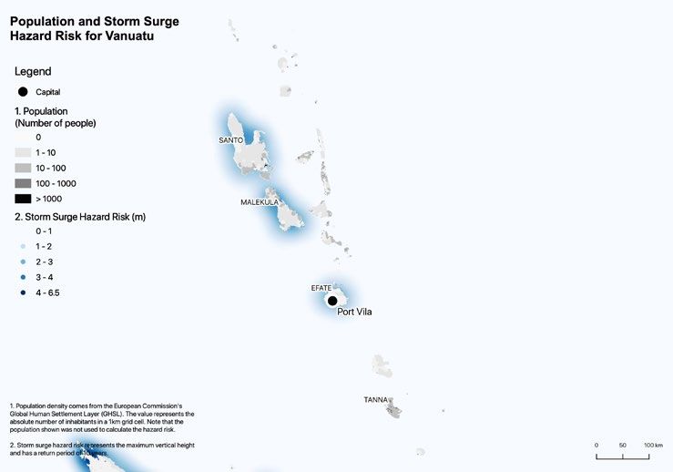
Box 1: Law and policy on disasters                     In doing so, Vanuatu became the first country in
in Vanuatu                                             the Pacific with a specific policy on displacement.
                                                       This policy adopts a broad concept of “disaster”
The government of Vanuatu in 2012 established          so that it encompasses both natural hazards and
a National Advisory Board (NAB) on Climate             a wide range of “man-made” displacements, such
Change and Disaster Risk Reduction Project             as evictions, land conflicts and those caused by
Management Unit within the Vanuatu Mete-               development. It approaches these holistically in
orology and Geo-Hazards Department. The                order to provide assistance to affected commu-
NAB is a committee made up of government               nities through a common set of principles and
and non-government members. It is Vanuatu’s            standards across a range of different scenarios.29
supreme policymaking and advisory body for
all disaster risk reduction and climate change         The national policy stresses durability, or the
programs, projects, initiatives and activities.   26   importance of finding “durable solutions” for
After the widespread damage caused by Cy-              people who are unable to return to their place of
clone Pam when it hit Vanuatu in March 2015,           origin. It is in line with the Guiding Principles on
the government sought to further strengthen            Internal Displacement.30 System- and sector-lev-
the country’s ability to mitigate climate change       el interventions cover a range of areas, including
and disaster risk.                                     governance, data, protection and capacity build-
                                                       ing and integrate consultation and participation
Launched in 2015, the National Policy on Cli-          mechanisms. This innovative approach com-
mate Change and Disaster Risk Reduction 2016           bines policy areas such as land, housing, health,
– 2030, highlights Vanuatu’s government re-            education, livelihoods, indigenous knowledge,
newed commitment to increase the country’s             security and access to justice with the effective
resilience to climate change impacts and disaster      application of the policy, through guidance on
risks provides a framework for mainstreaming           implementation, financing and monitoring.31
climate change and disaster risk reduction into
sustainable development processes. The policy          These policies linked to disaster and displace-
takes a practical approach, taking into consid-        ment are incorporated into Vanuatu’s Nation-
eration Vanuatu’s resources, exposure to risks         al Sustainable Development Plan (NSDP) for
and demographic situation. By promoting coop-          2030. The policy framework creates an inclusive
eration between local and national authorities         plan for a stable, sustainable and prosperous
and organisations, as well as between national,        country. Enhancing resilience and adaptation to
regional and international ones, it makes the          climate change and disasters are core priorities
country one of the global leaders in disaster          of the plan.32
prevention and recovery. 27

One of its most important initiatives was the
development of a national policy on resettlement
and internal displacement enacted in 2018. 28

                                                                        Sudden-Onset Hazards and the Risk of Future Displacement in Vanuatu   8
                                                                                                                     Background information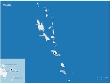
Vanuatu has experienced many disasters in recent histo-                                       Disaster displacement in Vanuatu:
    ry. The deadliest occurred in late December 1951 when                                         historical trends (2008-2020)
    a tropical cyclone killed 100 people.33 Tropical Cyclone
    Uma killed 48 people in 1987 and left about 5,000 peo-                                        Disasters have triggered almost 175,000 displacements
    ple homeless around Port-Vila on Efate Island.34                                              in Vanuatu since 2008 when IDMC began systematically
                                                                                                  monitoring data on the phenomenon. Cyclone Pam,
    The country lies on the so-called Ring of Fire, a seismical-                                  which struck the country in March 2015, represents
    ly active area of the Pacific that accounts for 75 per cent                                   more than 37 per cent of the total displacement. Tropical
    of the world’s volcanoes and more than 90 per cent of its                                     Cyclone Harold, which devastated Sanma and Penama
    earthquakes.35 The most significant geophysical event                                         provinces in 2020 and which our preliminary analysis
    occurred in 1999, when a 7.4-magnitude earthquake                                             shows displaced a quarter of the population, and rep-
    followed by a tsunami and landslides killed 12 people                                         resents 46 per cent of the total displacement (See box
    and destroyed numerous buildings. The epicentre of                                            3). Since 2008, IDMC has detected 19 displacement
    the quake was just off the east coast of Ambrym Is-                                           events triggered by weather-related hazards, such as
    land.36 The waves reached heights of about 6.6 metres                                         storms and floods, and geophysical hazards.
    on Pentecost Island in Baie Martelli. Large numbers of
    people were evacuated pre-emptively and fled inland
    and to higher ground before the waves struck. Many
    lives were saved as a result.37

    Figure 2: New disaster displacements in Vanuatu (2008-2020)

    90,000

    80,000

    70,000

    60,000

    50,000

    40,000

    30,000

    20,000

    10,000

        0
             2008   2009   2010   2011   2012   2013   2014   2015   2016   2017   2018    2019    2020

                                                                              Average 13,500 displacements

9   Sudden-Onset Hazards and the Risk of Future Displacement in Vanuatu
    Background information
BOX 2: Temporary and permanent church, community hall and a station for delivering
community relocations aid. Post-relocation assessments emphasised that
the relocated inhabitants were happy with the
Whole communities have been displaced and decision. They also highlighted, however, that the
then relocated through state-led initiatives in new site was prone to flooding.43
Vanuatu. The 2018 policy on disaster displace-
ment recognises that planned relocation is an In anticipation of the possible eruption of the
option of last resort. Where communities need Manaro Voui volcano, a state of emergency was
to move away from hazards, either temporarily declared on the island of Ambae in late September
or permanently, the policy highlights the need to 2017. The entire population of around 11,600
mitigate relocations’ potential negative effects. It people was then pre-emptively evacuated by the
also calls for safeguarding and protecting human National Disaster Management Office in early
rights and full social and economic recovery. 38 October.44 The state of emergency was lifted in the
This includes the development of sustainable latter part of that month when the government de-
livelihoods to ensure that displaced and relocated cided that conditions allowed for their return. Most
households can earn an income and reduce their of the evacuees did so within three days. Manaro
risk of poverty. The policy also recognises that
39 Voui continued to be active, however. Given the
more guidance is needed from the national and increasing risk of future eruptions, the government
provincial governments with regards to managing initiated a “second home” programme involving,
relocations with customary land holders. with their approval, the relocation of about 300
families.45 Some of these families relocated per-
The best known state-led relocation in Vanuatu manently and only returned to Ambae for special
involved the inhabitants of the Lateu communi- occasions. Others chose to return and only use
ty, located on Tegua Island in the Torres Islands the new site as a refuge during disaster events.46
chain.40 This garnered international attention
when a press release from the UN Environment
Programme called the villagers the first climate
change refugees.41 Since an earthquake in 1997,
the village had been increasingly affected by sea
water entering with the high tides. Its leaders be-
gan to ponder the possibility of moving the village
to Lirak. After years of discussions, assessments of
potential new locations, and the involvement of
the national authorities, the community formally
decided to relocate in 2004.42 Eventually about
50 people from 10 households were relocated to
the new community, which though lacking a school
for older children, had a kindergarten as well as a
Sudden-Onset Hazards and the Risk of Future Displacement in Vanuatu 10
Background informationThe data in table 1 above shows the estimated number Haiyan, which lashed the Philippines in November 2013.47
of new displacements by event. Added up over years or Winds from Cyclone Pam were estimated to have reached
decades, the figures may include people who have been 250 km per hour with gusts of 320 km per hour.48 About
displaced more than once. In this sense, the number 166,600 people were estimated to have been affected,
of new displacements does not necessarily equal the more than half the country’s population.49 Around 80
number of people displaced. per cent of the national housing stock was damaged or
destroyed.50 More recently, Tropical Cyclone Harold
Weather-related events triggered more than 152,000 struck Vanuatu in 2020, with severe impacts in Penama
new displacements, or almost 87 per cent of the total Province and even greater ones in Samna Province, home
new displacements recorded over the last two decades. to the country’s second biggest city, Luganville (see box 3).
Storms, particularly tropical cyclones, were the main
triggers. Tropical Cyclone Pam, the most powerful cy- Geophysical events triggered more than 23,000 move-
clone to hit Vanuatu in recent times, led to widespread ments representing almost a quarter of the displace-
destruction after striking on 12 March 2015 and contin- ment recorded between 2008 and 2020. Vanuatu in
uing through 14 March 2015, the day of the opening con- 2018 was preparing for the possible eruption of Manaro
ference of the Third UN World Conference on Disaster Voui, on the island of Ambae. Faced with potential risks
Risk Reduction held in Sendai, Japan. It was a Category to the whole island, the government evacuated its pop-
5 cyclone and was comparable in intensity to Typhoon ulation of around 11,600 people (see box. 2).
Table 1: Historical displacement events in Vanuatu (2008-2020)
Year Event Name Hazard Type New Displacements
2011 Tropical Cyclone Atu Storm 400
2012 Storm 700
2013 Paama Landslide Landslide 69
2014 Tropical cyclone Lusi Storm 100
2014 Efate flash floods Flood 200
2015 Cyclone Pam Storm 65,000
2017 Tropical Cyclone Cook Storm 700
2017 Vanuatu: Volcanic activity - Ambae island - 22/09/2017 Volcanic eruption 11,000
2017 Tropical Cyclone Donna Storm 3,000
2018 New Caledonia, Vanuatu: Earthquake/Tsunami - 5/12/2018 Earthquake 11
2018 Vanuatu: Volcanic activity - Ambae island - 18/3/2018 Volcanic eruption 600
2018 Vanuatu: Mudflow - Waluwebue, Ambae - 31/3/2018 Landslide 100
2018 Vanuatu: Landslide - Maewo - 12/9/2018 Landslide 500
2018 Vanuatu: Volcanic activity (Ambrym) - Ambrym - 15/12/2018 Volcanic eruption 300
2018 Vanuatu: Tropical Cyclone Hola - 6/3/2018 Storm 100
2018 Vanuatu: Volcanic activity (Manaro) - Ambae island - 19/7/2018 Volcanic eruption 11,000
2019 Papua New Guinea; Vanuatu: Tropical Cyclone Oma - 13/2/2019 Storm 1,000
2020 Vanuatu: Volcanic ashfall - Tafea (Tanna island) - 31/03/2020 Volcanic eruption 8
2020 Vanuatu, Solomon Islands, Fiji, Tonga: Tropical Cyclone Harold - 01/04/2020 Storm 80,000
11 Sudden-Onset Hazards and the Risk of Future Displacement in Vanuatu
Background informationBOX 3: Two devastating cyclones in Sanma province in Vanuatu, 80 to 90 per cent
five years, cyclones Pam and Harold of the population have lost their homes. 54 As of
6 June 2020, more than 6,200 individuals were
Tropical Cyclone Pam hit Vanuatu in March 2015, still reported as displaced, spread out across
destroying a significant proportion of the hous- 569 host families and 178 evacuation centres. 55
ing stock and displacing more than 65,000 peo- Many communities remained cut off from assis-
ple. Most of the national population was affected, tance because of flooded and damaged roads.
with around 166,000 people on 22 islands in
need of emergency assistance, including the Vanuatu has been relatively spared from the
entire population of Port Vila.51 effects of the COVID-19 pandemic, but response
to the disaster has been slowed by restrictions
Around 17,000 buildings were damaged or aimed at preventing the disease’s spread. Over-
destroyed, including houses, schools, medical seas humanitarian workers, for instance, have
clinics and other medical facilities. The cyclone not been allowed to enter the country. 56
destroyed crops on a large scale and affected the
livelihoods of at least 80 per cent of Vanuatu’s Recent assessments suggest that about 16,000
rural population. 52 dwellings were damaged and more than 5,000
destroyed by Cyclone Harold. 57 According to
The economic losses associated with the cy- the 2016 census, 75 per cent of dwellings in
clone were estimated at about $449.4 million, Vanuatu are traditional and semi-permanent
or around 64 per cent of Vanuatu’s GDP. Addi-
53 structures, making them particularly vulnera-
tional negative economic impacts, however, have ble to intense hazards. These houses suffered
been felt for several years as a result of lingering the heaviest damage when the cyclone struck
production losses and higher production costs. Sanma province.
Cyclone Harold hit the Solomon Islands on 2 The recent Post-Disaster Needs Assessments
April 2020, causing widespread flooding. It (PDNA) conducted by Vanuatu’s government
gained strength and made landfall in Vanuatu estimates combined economic losses from
on 6 April as a category 5 cyclone with sustained Covid-19 and disasters to be $617 million, or
winds of more than 200 km/h. Harold continued about 61 per cent of GDP, in 2020.58
moving south-east to Fiji, where it displaced
another 10,000 people before attaining its full Individual households have their own time-
strength on Tonga, where it coincided with a frames for recovery, distinct from the nation-
king tide phenomenon, displacing 500 people. al recovery process. Initially safe temporary
It was the most violent cyclone to strike the housing is a priority. Durable solutions take
archipelago since Cyclone Pam. time, especially because they are linked to the
recovery of livelihoods, whether through agri-
IDMC estimates, based on damages to housing, culture or some other income source. As incomes
that more than 80,000 people have been dis- have been particularly affected by Covid-19,
placed across Vanuatu as a result of Cyclone displacement and recovery will be protracted.
Herald. This represents almost a quarter of Long-term support may be required.59
the country’s population. In some areas, like
Sudden-Onset Hazards and the Risk of Future Displacement in Vanuatu 12
Background informationDisaster
displacement risk
in Vanuatu
The baseline established by our global disaster displace- Displacement risk: two key metrics and
ment risk model presents results at the national level how to read them
and provides insight into future displacement situations.
This analysis of future displacement risk associated with Our multi-hazard Global Disaster Displacement Risk Model
sudden-onset hazards, including earthquakes, tsunamis, provides two metrics at the national level: the Average
storm surges and cyclonic winds, considers a large Annual Displacement (AAD) by hazard and the Probable
number of possible hazard scenarios, their likelihood, Maximum Displacement (PMD) by hazard. Because these
and the potential damages to housing, which is used as metrics are based on a global model, the granularity of the
a proxy for displacement. data is low and estimates should be considered conservative.
Figure 3: How we calculate Probable Maximum Displacement (PMD) and Average Annual Displacement (AAD) by hazard
PMD AAD
Accumulated displacement
5.0 50
4.5 45
Displacement per thousand (,000)
Accumulated displacement (,000)
4.0 40
3.5 35
3.0 30
2.5 25
2.0 20
1.5 15
1.0 10
0.5 5
0.0 0
0 2000
Time frame
Source: UNDRR, 2015
13 Sudden-Onset Hazards and the Risk of Future Displacement in Vanuatu
Disaster displacement risk in VanuatuBox 4: The concept of risk The model considers the likelihood of different hazards, as
return periods well as their intensity, to estimate the number of people
that could be forced to flee from their habitual place of
The concept of return period is often misunder- residence as a result of severe damage or destruction
stood. If a disaster or displacement event has a that could render housing uninhabitable. Many factors,
500-year return period, that does not mean it including insurance penetration and coverage, coping
will only occur once every 500 years. Nor does capacity, humanitarian responses and recovery efforts,
it mean that if it occurred today, it would not also influence the duration and severity of displacement.
recur for another 500 years. Rather, it means
that it happens once every 500 years on average. Probable Maximum Displacement (PMD) by hazard
If there were four extreme events in the space
of a century followed by 19 centuries without Probable Maximum Displacement (PMD) is the maxi-
any, the return period would still be 500 years. 60 mum displacement expected within a given time period.
It answers the question: What is the maximum expected
The longer an event’s return period, the less displacement within a range of X years? It represents
likely it is to occur in any single year. It is also the outlier event that could occur during a specific time
possible for an event with a 500-year return frame. PMD can be used to determine the size of shelters
period not to occur at all over five centuries. The and other assets that a government needs to provide
most common misconception is that a 100-year to cope with the potential magnitude of displacement.
flood will only occur once per century. That is
not true. There is a small probability that such A hundred years does not mean it will occur every
an intense event could happen every year. If a 100 years (see Table 2). There is a common miscon-
100-year flood happened last year, it can happen ception that an event with a 100-year return peri-
again before the next century, or even this year. od will only occur once a century, but that is not the
It is also possible for such an event to not occur case (see Box 4). There is a small probability that such
within a 100-year period. an intense event could happen much more frequently.
PMD for different return periods is best expressed as
That said, Houston in Texas experienced 500- the probability of a given amount of displacement being
year floods for three years in a row between exceeded over different periods of time.
2015 and 2017, the last one caused by hurricane
Harvey. This prompted the city’s authorities to Even in the case of a 1,000-year return period, there is a
revise zoning regulations to account for changes five per cent probability of PMD being exceeded over a
in the flood drainage basins around it. 50-year time frame. This metric is relevant to planners and
designers of infrastructure projects because investments
We expect to see many similar revisions as are often made with an expected lifespan of 50 years.
climate change alters the frequency and in-
tensity of extreme events, and rapid urban Average Annual Displacement (AAD) per hazard
sprawl shrinks the natural areas available to and multi-hazards
absorb floodwater.61
AAD is a measure of the magnitude of future displacement
by hazard type that a country is likely to experience. It does
not reflect the number of displacements it will face each
year, but the number it can expect per year considering all
the events that could occur over a long timeframe. AAD
is a compact metric with low sensitivity to uncertainty.
Sudden-Onset Hazards and the Risk of Future Displacement in Vanuatu 14
Disaster displacement risk in VanuatuMulti-hazard AAD is calculated by aggregating the fig-
ures of each hazard type. This metric encompasses the Total: 3,677
probability that cyclonic winds and storm surges could
destroy one single house, and could be double “counted”
when calculating multi-hazard AAD. The probability that
double severe damages occur is not nil.
Results: displacement risk by hazard
EARTHQUAKE STORM SURGE
As described above, AAD represents the annualized
accumulated effect of all the catalogue events. It is
a compact metric which accounts for the probable
417 1,125
displacement of small-to-medium and extreme events.
Our model suggests that around 3,680 people could be
displaced by disasters in Vanuatu in any given year of
the future . This is its AAD (see table 3).
AAD is useful for providing a sense of the scale of the an- TSUNAMI CYCLONIC WIND
nual risk of displacement, but it tends to hide potential out-
liers. High-intensity but low-frequency events that trigger
mass displacement could take place over extremely long-
1 2,134
time spans. A category 5 cyclone or a 7-magnitude earth-
quake, for instance, could strike Vanuatu unexpectedly and
Table 2: Concept of probabilities for different return periods
Return period (years) Probability of displacement Probability of displacement Probability of displacement
exceedance per year exceedance in 20-year timeframe exceedance in 50-year timeframe
25 4.0% 56% 87%
50 2.0% 33% 64%
100 1.0% 18% 39%
250 0.4% 8% 18%
500 0.2% 4% 10%
1,000 0.1% 2% 5%
Table 3: Displacement risk by hazard in Vanuatu
Return Period in years
Hazard ADD PMD 10 25 50 100 250 500 1,000
Storm Surge 1,125 3,600 6,200 10,900 12,000 20,000
Cyclonic Wind 2,134 1,100 23,000 32,000 41,000 50,000 60,000
Earthquake 417 850 2,500 6,000 10,200 13,000 17,000
Tsunami 1 1 20 250
15 Sudden-Onset Hazards and the Risk of Future Displacement in Vanuatu
Disaster displacement risk in Vanuatucause significant displacement. Such extreme events may Risk of displacement as a result of storm surges
not have occurred since record keeping began, but they
can still take place, and it is important that the country be As a cyclone moves across an ocean, its winds push the
prepared for them. Cyclones Eric and Nigel which struck water into a wall as it nears landfall, creating a storm surge.
the archipelago within a week in 1985 and Uma in 1987 are Impacts depend on coastal topography and the tides.
examples of disasters at an unprecedented level. The risk of displacement enters uncharted territory with
king tides, which occur when extreme weather events
The model considers the likelihood of different hazards and coincide with uncommonly high tides caused when the
their maximum intensity at different return periods (see gravitational pull of the moon and the sun are aligned.62
table 3). This national-level resolution is based on glob- Storm surges represent Vanuatu’s highest displacement
al-level observations and data. It provides multi-hazard risk. On average 1,125 people can be expected to be
risk metrics and allows risk levels to be compared across displaced per year considering all the events that could
countries, regions and hazard types. At this scale, the occur over the return period.
estimates should therefore be considered conservative.
Looking at PMD, there is a 56 per cent probability that
a storm surge will displace about 6,200 people at some
point in the next 20 years. There is a 33 per cent prob-
ability that Efate island will experience storm surges of
around two to three metres during the same time period.
Map 2: Storm surge risk map
Sudden-Onset Hazards and the Risk of Future Displacement in Vanuatu 16
Disaster displacement risk in VanuatuRisk of displacement as a result of On average 2,134 people are expected to be dis-
cyclonic winds placed per year considering all the events that could
occur over the return period. Winds with speeds
The risk from cyclonic winds in Vanuatu is very high. greater than 190km/h could strike Vanuatu. They
The country is located to the south of the equator in could reach speeds of more than 200km/h in the
the South Pacific convergence zone, which is known north and the south of the archipelago. Looking
for frequent cyclones. again at PMD, there is a 64 per cent probability that
a cyclonic wind will displace about 32,000 people
Cyclones use warm, moist ocean air as fuel to gather at some point in the next 50 years.
force. They stay strong for longer periods in the
South Pacific convergence zone because they are
not obstructed by large land masses that would
deprive them of their fuel and slow them down with
greater friction than exists on the sea surface.63
Map 3: Cyclonic wind risk map
17 Sudden-Onset Hazards and the Risk of Future Displacement in Vanuatu
Disaster displacement risk in VanuatuRisk of displacement as a result of earthquakes In terms of PMD, there is a 39 per cent probability
that an earthquake will displace about 6,000 people at
The archipelago of Vanuatu is in a seismically active some point in the next 50 years. The map below shows
area above the collision between the Australia and Pa- earthquake intensity zones and indicates where there
cific tectonic plates. The displacement risk associated is a 10 per cent probability that degrees of intensity will
with earthquakes is high. On average, 417 people are be exceeded in the next 50 years.
expected to be displaced per year given all the events
that could occur over the return period.
Map 4: Seismic hazard risk map
Sudden-Onset Hazards and the Risk of Future Displacement in Vanuatu 18
Disaster displacement risk in VanuatuRisk of displacement as a result of tsunamis The archipelago is somewhat protected by coral reefs that
could dissipate wave energy, but the islands are still vulnera-
Vanuatu is particularly vulnerable to tsunamis. During ble to significant damage from tsunamis, the effects of which
a tsunami, waves push a large amount of water above are greatly amplified if they coincide with high or king tides.
sea level onto the shore. This is known as the run-up.
The maximum vertical height above sea level reached On average, one person is expected to become dis-
by a tsunami onshore is estimated to be around three placed per year considering all the events that could
to four metres for most of the coastal areas at risk. It occur over the return period. In terms of PMD, there is
could be higher than 15 to 20 metres, however, on the a five per cent probability that a tsunami will displace
west coast of Santo and Malekula islands. about 80 people at some point in the next 50 years.
Map 5: Tsunami risk map
19 Sudden-Onset Hazards and the Risk of Future Displacement in Vanuatu
Disaster displacement risk in VanuatuToward
risk-informed
decision making
Disasters have triggered about 290 million displacements access to water, food and services such as healthcare
around the world since we began collecting data on the and education, and disrupted social networks.
phenomenon in 2008. This is more than three times the
figure for conflict and violence displacements. Given its Our data shows that internal displacement is on the
scale, the need to address the risk of disaster displace- rise globally. Addressing the phenomenon will require
ment has been explicitly recognised in global policy significant humanitarian and development measures,
agendas on disaster risk reduction and climate change. but resources are becoming increasingly stretched to
The UNFCCC’s Warsaw International Mechanism on Loss service a growing number of priorities. This calls for a
and Damage associated with Climate Change Impacts has new and more comprehensive approach to mitigate and
established a task force on displacement, which recognis- reduce the risk of medium and long-term displacement.
es the need to “avert, minimise and address displacement
related to the adverse impacts of climate change.64 Why do we need to understand risks?
Global agreements on disaster risk reduction, such Monitoring disaster displacement typically means ac-
as the Hyogo Framework for Action 2005–2015 and counting for the number of people displaced or homes de-
the Sendai Framework for Disaster Risk Reduction stroyed after a disaster occurs. This information provides
2015–2030, have promoted and significantly increased a baseline to inform emergency responses and disaster
efforts to reduce disaster risk in general. The Sendai management. Retrospective analysis, however, is only
framework recognises the importance of addressing one element of informed planning and decision making,
displacement risk in particular.65 particularly when it comes to mitigation and prevention. It
should be complemented with probabilistic analyses and
Despite these advances, the number of disaster dis- metrics, such as those presented in this report.
placements is likely to increase in the future. Weath-
er-related hazards account for more than 87 per cent As the UN Office for Disaster Risk Reduction (UNDRR) has
of all those recorded to date, and climate change and emphasised: “Catastrophic earthquakes or tsunamis may
the increasing concentration of populations in exposed only happen every 500 or 1,000 years in any given place.
areas mean that ever more people are at risk. As such, even though records may go back centuries, most
of the extreme events that could potentially occur have not
People displaced by disasters face similar challenges happened yet. And, although data on disaster loss provides
to those who flee conflict and violence. Many lose their a guide to the past, it is insufficient to predict and estimate
homes, assets and income. They face insecurity, reduced damages that may occur at present and in the future.“
Sudden-Onset Hazards and the Risk of Future Displacement in Vanuatu 20
Toward risk-informed decision makingThe risk of future displacement is determined by the Box 5: The definition of disaster risk
way in which policies and processes influence peo-
ples’ exposure and vulnerability to hazards, and many /rɪsk/
governments and operational stakeholders recognise The potential loss of life, injury, or destroyed or
the need to understand the issue. Demand for models damaged assets which could occur to a system,
and tools to estimate its potential scale and severity is society or a community in a specific period of
growing, but developing and improving them takes time. time, determined probabilistically as a function
of hazard, exposure, vulnerability and capacity
Estimating displacement risk using probabilistic approach- (UNDRR – 2017). Risk is the possibility of some-
es requires highly localised and detailed information. Many thing bad happening.
governments, however, lack the data needed to validate
models and conduct comprehensive quantitative assess-
ments. More capacity building is needed before they will
be able to adapt models to their own needs and apply the
results to policy development and investment planning.
Investments should be made in understanding disaster
risk in all its dimensions: the exposure and vulnerability
of people and assets, hazard characteristics, response
capacity and environmental factors. Such understand-
ing would also inform preparedness measures and
effective responses that build back better.
The initial results from our probabilistic model provide useful
baselines for policymakers working to implement the Sendai
framework, the Paris Agreement of the UN Framework
Convention on Climate Change (UNFCCC), the Warsaw
International Mechanism and the Agenda for Humanity.
Families who moved to
Santo during the
evacuation of their home
island, Ambae due to the
Manaro eruptions, waiting
for their roofs being
repaired after TC Harold.
April 2020, © UNICEF/
UNI324730/Shing
21 Sudden-Onset Hazards and the Risk of Future Displacement in Vanuatu
Toward risk-informed decision makingMethodological
considerations
and caveats
IDMC’s global disaster displacement In short, they allow decision makers to make risk-in-
risk model formed efforts to prevent displacement happening in
the first place and reduce its impacts when it does occur.
We began a unique probabilistic modelling exercise in
2017 with our global disaster displacement risk model, The model can be adapted to support operations in real
which assesses the likelihood of such population move- time by indicating the number and location of homes
ments in the future. severely damaged or destroyed by observed and fore-
casted hazards. This has the potential to make responses
Since 2011 the UN Office for Disaster Risk Reduction more timely and better targeted and ultimately save
(UNDRR), has rigorously analysed the risk of economic lives. It also provides a benchmark for measuring pro-
losses due to disasters risks in its Global Assessment gress toward DRR and climate change policy objectives.
Report (GAR).66 One critical gap, however, concerns
evidence and analysis of the risk of disaster-related Our Displacement risk model is determined by three factors:
displacement, a problem which hinders the effective
reduction of both displacement and disaster risk. 1. Hazard: the likelihood of different hazards and
their intensity
This risk profile for Vanuatu lays the groundwork for 2. Exposure: the number of people and assets exposed
addressing this gap. It presents the first results gener- to hazards
ated by IDMC’s global disaster displacement risk model 3. Vulnerability: the likelihood of exposed buildings
in 2017, which builds upon and extends the analysis being damaged or destroyed
presented in the GARs.67
The model does not consider people’s economic and
The model’s results can be used to inform national and social vulnerability. It covers only the physical aspect
sub-national disaster risk reduction (DRR) measures, by looking at the extent of damage and destruction
identify areas where large numbers of people could be that hazards of different intensities are likely to cause
made homelessness by disasters, and calculate evacu- (see figure 4).
ation-centre capacities and the amount of investment
needed to support displaced people.
Sudden-Onset Hazards and the Risk of Future Displacement in Vanuatu 22
Methodological considerations and caveatsFigure 4: Displacement risk: How is it estimated?
Probability of
being destroyed
Probability of
= X X being damaged
Probability of not
being affected
Displacement risk Hazard Exposure Vulnerability
Phenomenon that may People and buildings How different buildings react
cause displacement in hazard-prone areas to different hazard intensities
(e.g. Earthquake)
The model does not account for pre-emptive evacua- Caveats and future improvements
tions, which means its estimates are inherently con-
servative. In countries with strong disaster prepar- This risk assessment considers a large number of possi-
edness capacity where such evacuations occur, such ble scenarios, their likelihood, and associated damages
as Bangladesh, China, Cuba, Japan and Viet Nam, it to housing. Our risk model is informed by and relates to
underestimates the number of reported displacements medium to large-scale events, but small and recurrent
significantly. In countries with weaker capacity, and for events still require the daily monitoring of empirical
hazards such as earthquakes for which early warning information to understand the true historical scale of
systems are limited, historical data and the model’s displacement.
estimates are a closer fit.
The results are a probabilistic indication of the potential
What about displacement risk associated with impact of events, but underlying limitations and simpli-
slow-onset hazards? fications mean the figures for individual events and the
calculated impacts on particular assets are unlikely to
Our global model only considers displacement risk as- be precise.
sociated with sudden-onset hazards. It is also possible
to consider slow-onset phenomena such as drought, Our global model, presenting results at a national level,
desertification, sea level rise and coastal erosion. We aims to provide insight into future displacement situa-
have, for example, modelled drought displacement risk tions. It allows decision-makers to take risk-informed
in the Horn of Africa.68 decisions that can help prevent and reduce the risk of
displacement before it happens. The model calculates
Such complex exercises, however, need to take many how many people will be displaced on average every
human factors into consideration. They are time-con- year by sudden-onset hazards, (earthquakes, tsunamis,
suming and require historical data on various indicators floods, cyclonic winds and storm surges). Results are
to validate and generate confidence in the results. We based on the likelihood of housing destruction and
do not yet have such a model for countries in the Pacific, show that, globally, 14 million people on average could
but we would be willing to develop one if there were be displaced in any given year. The model also calculates
interest and the resources to do so. the probable maximum displacement (PMD) that could
be expected within a given return period. (See section
Two key metrics and how to read them).
23 Sudden-Onset Hazards and the Risk of Future Displacement in Vanuatu
Methodological considerations and caveatsThe displacement risk metrics were developed at the people whose destroyed dwellings were attributed to dis-
global level and so have low granularity, but they are asters”. Sendai’s target G and particularly G-6 could be also
still a useful baseline and guide. The model has ana- monitored using data on pre-emptive evacuations. These
lysed more the 4.5 million cells containing proxies for indicators could help to calibrate the next improvements of
exposed assets and people at a resolution of five square displacement risk models.
kilometres, and one square kilometre along the coast.
Millions of hazard scenarios have also been compiled. We are working closely with the Swiss Federal Institute
The resolution used in 2017, however, did not allow us of Technology in Zurich (ETHZ), Oxford University and
to run a proper risk assessment for riverine floods in other partners to improve the model’s ability to predict
small island states. Nor is its current resolution suitable displacement risk for sudden-onset hazards, including
for informing land use and urban planning decisions. floods in small island states. Increasing the resolution of
the exposure layer from five square kilometres to one
The model excludes displacements associated with pre-emp- allows for a more granular assessment of the people
tive evacuations. This information must be collected in the and assets exposed. 69
aftermath of disasters. Where no specific indicators exist to
monitor disaster displacement, states could report on other This, coupled with a rerun of hazard scenarios using
indicators established by the Sendai framework and the the latest technologies, has produced a more accurate
Sustainable Development Goals (SDGs) without duplication estimate that suggests the number of people at risk of
of effort. Target B of the Sendai framework, for example, displacement from all hazards is significantly higher than
includes the “number of directly affected people attributed previously thought. Better resolution also allowed the
to disasters”. It is linked to SDG targets 1.5, 11.5 and 13.1, disaggregation of displacement risk figures by urban
which refer to monitoring and reporting on the “number of and rural locations.
In the aftermath of TC
Harold, April 2020,
© UNICEF/UNI324714/
Shing
Sudden-Onset Hazards and the Risk of Future Displacement in Vanuatu 24
Methodological considerations and caveatsEndnotes
1 Platform on Disaster Displacement, “Key Definitions”, 2017 21 Asian Development Bank, “The Emergence of Pacific Urban
Villages, Urbanization Trends in the Pacific Islands”, 2016
2 UNDRR, “Disaster Risk”, 2 February 2017
22 UN-Habitat, “National Urban Policy Pacific Region”, 2020.
3 OCHA, “Vanuatu”, accessed on 20 January 2021
23 G. Kiddle, D. McEvoy, D. Mitchell, P. Jones, S. Mecartney,
4 Cop23, “Vanuatu”, accessed on 20 January 2021; World Bank
“Unpacking the Pacific Urban Agenda: Resilience Challenges
Data, “Population – Vanuatu”, accessed on 20 January 2020
and Opportunities”, 2017.
5 Republic of Vanuatu, “Mini-Census post TC Pam”, 2016
24 Ibid
6 Republic of Vanuatu, “2nd National Communication to
25 C. Butcher-Gollach, “Planning and Urban Informality—
UNFCC”, 2014
Addressing Inclusiveness for Climate Resilience in the Pacific”,
7 Ralph Regenvanu, “The traditional economy as source of 2017.
resilience in Vanuatu”, 2009
26 UNDRR, “National Advisory Board on Climate Change and
8 FAO, “An assessment of the impact of climate change on Disaster Risk Reduction”, accessed on 27 January 2021
agriculture and food security, a case study in Vanuatu”, 2007
27 Government of Vanuatu, “Vanuatu Climate Change and
9 Ibid Disaster Risk Reduction Policy 2016-2030”, 2015; UNDRR,
“Vanuatu: Climate change and disaster risk reduction policy
10 Ibid
2016-2030”, accessed 3 February 2021
11 VMGD, “Cloud Nasara”, accessed on the 21 January 2021
28 Government of Vanuatu, “National Policy on Climate Change
12 UNDP, “Vanuatu, Climate change adaptation”, accessed on the and Disaster-Induced Displacement”, 2018
21 January 2021
29 UNDRR, “Vanuatu: National policy on climate change and
13 Republic of Vanuatu, “2nd National Communication to disaster-induced displacement”, 2018
UNFCC”, 2014
30 Jennifer Day, Margaretha Wewerinke-Singh, “Learning
14 IFHV, “World Risk Report 2020 Focus: Forced Displacement from survivors of development-induced displacement:
and Migration”, 2020 Operationalising Vanuatu’s New Displacement Policy toward
an inclusive Capital City”, Background Paper to the Global
15 UNDRR, “Poorly planned urban development”, accessed on
Report on Internal Displacement (GRID)”, 2019
the 30 November 2020
31 Barbara Essig, Sebastien Moretti and Platform on Disaster
16 Neil L. Andrew et al., “Coastal proximity of populations in 22
Displacement Secretariat, “Preventing and preparing for
Pacific Island Countries and Territories”, 30 September 2019
disaster displacement”, 2020
17 Republic of Vanuatu, “2nd National Communication to
32 Government of Vanuatu, “Vanuatu 2030: The People’s Plan
UNFCC”, 2014
(National Sustainable Development Plan 2016 to 2030)”, 2016
18 Pacific Climate Change Science Program, “Current and future
33 EMDAT, “Public Databased”, accessed 22 January 2021
Climate of Vanuatu”, 2013
34 UNDRO, “Vanuatu Cyclone Uma Feb 1987 UNDRO Situation
19 ABC, “Vanuatu village relocated due to rising sea level”, 2005
Reports 1-6”,1987
Scott Leckie (ed.), “Land Solutions for Climate Displacement”,
35 National Geographic, “Ring of Fire”, accessed on 22 December
2014; SPREP, “Post Relocation Survey Report: Tegua
2020; USGC, “Earthquake Glossary, Ring of Fire”, accessed on
Community, Torba Province, Vanuatu”, accessed on 28
22 December 2020
January 2021
36 USGS, “Today in Earthquake History, on November 26th”,
20 UNHABITAT, “Urban Resilience Hub, Port Villa”, accessed on
accessed on 22 January 2021
the 21 January 2021
25 Sudden-Onset Hazards and the Risk of Future Displacement in Vanuatu
Endnotes37 Rory Walshe and Patrick Nunn, “Integration of Indigenous 55 IDMC, IOM, “Displacement Tracking Report, Vanuatu, Tropical
Knowledge and Disaster Risk Reduction: A Case Study from Cyclone Harold”, June 2020
Baie Martelli, Pentecost Island, Vanuatu”, December 2012
56 IDMC, “Tropical Cyclone Harold And Covid-19: A Double
38 Government of Vanuatu, “National Policy on Climate Change Blow To The Pacific Islands”, April 2020
and Disaster-Induced Displacement”, 2018
57 Government of Vanuatu, “Post Disaster Needs Assessment-
39 Line Jensen, “The Pacific corner series: Relocation and climate Harold – COVID-19”, October 2020
change adaptation strategies”, 2019
58 Ibid
40 Taito Nakalevu, Brian Phillips, “Post Relocation Survey Report:
59 Ibid
Tegua Community, Torba Province, Vanuatu”, 2015
60 UNDRR, “Global Assessment Report – Risk Atlas”, 2017
41 GIZ, “Home lands island and archipelagic states’ policymaking
for human mobility in the context of climate change”, 2020 61 GFDRR, “Understanding Risk, 100 Year Flood”, accessed on
the 30 November 2020
42 Patricia Siméoni, Valérie Ballu, “Le mythe des premiers
réfugiés climatiques : mouvements de populations et 62 IDMC, “Silent Disasters: Preparing For The King Tide, Expert
changements environnementaux aux îles Torrès (Vanouatou, Opinion”, March 2020
Mélanésie)”, 2012
63 Smithsonian, “Hurricanes, Typhoons, And Cyclones”, accessed
43 Olivia Warrick, “The adaptive capacity of the Tegua island on the 30 November 2020
community, Torres Islands, Vanuatu”, May 2011
64 UNFCCC, “Task Force on Displacement”, accessed on 22
44 IDMC, “Indonesia and Vanuatu, Displacement for good reason, January 2021
Spotlight, Global Report on Internal Displacement 2018”,
65 UNDRR, “Sendai Framework for Disaster Risk Reduction
May 2018; Chris Firth, “Ambae Volcano’s Crater Lakes Make
2015-2030”, 2015
It a Serious Threat to Vanuatu,” September 2017; Reuters,
“Vanuatu orders full evacuation of Ambae island as volcano 66 UNDRR, “Revealing risk, Redefining Development
threatens to erupt”, September 2017 GAR11”,2011
45 The Guardian, “Island of no return: Vanuatu evacuates entire 67 UNDRR, “Global Assessment Report on Disaster Risk
population of volcanic Ambae”, April 2018; Radio New Zealand, Reduction”, 2021
“Vanuatu govt finalising ‘second home’ for Ambae residents”,
68 IDMC, “Monitoring methodology for displacement associated
June 2018
with drought”, 2020
46 Government of Vanuatu, “Progress made on Maewo second
69 for more information or to collaborate with IDMC on this,
home for Ambae people”, October 2018
please contact info@idmc.ch
47 WMO, “Severe Tropical Pam”, 2015
48 Ibid
49 UNDAC, “Tropical cyclone Pam, Vanuatu”, 2015
50 AIDR, “Cyclone Pam in Vanuatu: learning from the low death
toll”, 2015
51 IDMC, “Global Report on Internal Displacement 2016”, May
2016
52 Government of Vanuatu, “Post-Disaster Needs Assessment,
Cyclone Pam”, 2015
53 Monetary value expressed in 2015 currency rate.
54 IDMC, “Tropical Cyclone Harold And Covid-19: A Double
Blow To The Pacific Islands”, April 2020
Sudden-Onset Hazards and the Risk of Future Displacement in Vanuatu 26
EndnotesYou can also read