TEAR DOWN' THE FENCES: DEVELOPING ABM INFORMED DESIGN STRATEGIES FOR UNGATING CLOSED RESIDENTIAL COMMUNITIES
←
→
Page content transcription
If your browser does not render page correctly, please read the page content below
‘TEAR DOWN’ THE FENCES: DEVELOPING ABM INFORMED
DESIGN STRATEGIES FOR UNGATING CLOSED RESIDENTIAL
COMMUNITIES

Developing ABM informed design strategies for ungating closed residential
communities

                WENZHAO XU1 , XIAORAN HUANG2 and GEOFF KIMM3
                1
                  University of Pennsylvania
                1
                  wenzhao@alumni.upenn.edu
                2
                  North China University of Technology, Swinburne University of
                Technology
                2
                  xiaoran.huang@ncut.edu.cn
                3
                  Swinburne University of Technology
                3
                  gkimm@swin.edu.au

                Abstract. Embedded in China’s urbanization process, the growth
                of gated residential estates has gradually induced severance of urban
                spaces, resulting in an underutilization of public amenities, a lack of
                walkable permeability, and congestion of traffic. Responding to these
                negative effects on urban development, the CPC has released a guideline
                in February 2016 to prohibit the development of any new closed
                residential areas in principle and to advocate ungated communities.
                In this paper, we utilized ABM simulation analysis to test different
                degrees of openness, the position of new entrances/openness, and
                pedestrian network typologies, aiming to explore feasible strategies
                to accommodate the new urban design agenda. A series of typical
                gated compounds in Beijing were selected for comparative case studies,
                conducted under different degrees of openness of each case and under
                diverse ungating modes between cases. On the basis of these analyses,
                we summarized a sequence of pedestrian-centric design strategies,
                seeking to increase the communities’ permeability and walkability by
                suggesting alternative internal and external road network design options
                for Beijing urban renewal. By integrating quantified simulation into the
                empirical method of urban design, our research can positively assist and
                inform urban practitioners to propose a more sustainable urbanity in the
                future.

                Keywords. Gated community; agent-based modeling; pedestrian
                simulation; computer-aided urban design; road network
                optimization.

PROJECTIONS, Proceedings of the 26th International Conference of the Association for Computer-Aided
Architectural Design Research in Asia (CAADRIA) 2021, Volume 2, 467-477. © 2021 and published by the
Association for Computer-Aided Architectural Design Research in Asia (CAADRIA), Hong Kong.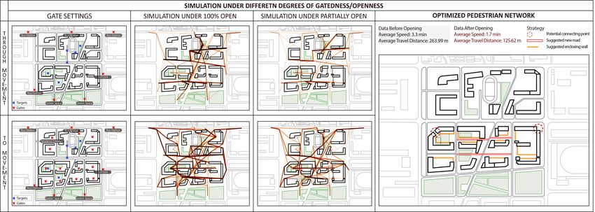
468                    W. XU, X. HUANG AND G. KIMM

1. Introduction
The growth of gated communities and compounds is ubiquitous in China’s
urbanization process, with a history traced back to the introspective courtyard
archetype of the feudal monarchy period of China (Miao et al., 2009). Earlier
this century, Chinese urban planners and researchers noticed that multiple
urban problems induced by gated compounds have gradually emerged. The
closedness and segregation of gated communities tended to fragment urban
spaces, exacerbating the disconnected traffic networks, underutilization of public
amenities and social-geographical inequality. Responding to these negative effects
on urban development, the CPC (Central Committee and State Council) has
released a guideline in February 2016 to gradually prohibit the development of
any new closed residential areas in principle, and to advocate ungated communities
with denser and more public road networks. Preceding studies provide supporting
evidence for the central government’s wish to ungate China’s superblocks: small
blocks mostly produce a highly interconnected pedestrian network (Jacobs, 1961)
and a more highly connected and walkable built environment is associated with
better sustainability and physical health (Alfonzo et al., 2014). As prior gated
community researches have commonly concentrated on empirical sociological
studies (Low, 2001; Le Goix, 2005) and regional analysis of urban morphology,
much less effort has been given to community-scale ungating strategy analysis.
It is of great significance to develop an effective ungating strategy from a
neighborhood’s perspective, seeking to promote a better city form with permeable
spatial patterns facilitating accessibility and maximising connectivity (Lynch,
1981; Talen, 2002).
    Agent-based models (ABM) are widely used for the dynamic simulation
of the simultaneous operations and interactions of multiple agents (Grimm et
al., 2005). In the field of urban design, ABM is a useful tool for circulation
simulation, as a person can be identified and traced as an individual entity (Ronald
et al., 2007). The specificity and fine-grain analysis of ABM makes it suitable
for neighborhood-scale investigation and studies of walkability and its essential
dimensions. One such crucial dimension, permeability, is utilized in this research
to investigate efficacious opening strategies to prosecute the objectives of the
new urban design agenda of the CPC through improved walkability. We define
permeability in this work as two complementary metrics of through-movement
and to-movement (Hiller et al., 1993) to construct a two-tier system in the
simulation process.       Beijing, with widespread private secured residential
compounds in its metropolitan area, is an apposite site of investigation. In our
experiment, comparative ABM simulation analysis case studies of permeability
with or without gating were undertaken for compounds around the Beijing CBD
area. The research utilized PedSim, a free Grasshopper plug-in to model the
movement and circulation of pedestrians (www.food4rhino.com/app/pedsim).
Based on the existing population density and the location of public amenities,
we proposed different strategies of opening with new entrances/openness, and
simulated pedestrian patterns accordingly. We subsequently summarized diverse
pedestrian-centric design strategies of each community type, suggesting an
optimized alternative road network structure with shortened walking distances and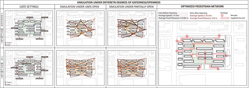
‘TEAR DOWN’ THE FENCES: DEVELOPING ABM INFORMED                             469
       DESIGN STRATEGIES FOR UNGATING CLOSED RESIDENTIAL
                          COMMUNITIES

provision of more travel options. This digital design approach could extensively
explore effective and diversified developments of open communities in the future
instead of coercive removal of restricted gates.

2. Background
2.1. GATED COMMUNITIES AND PERMEABLE WALKING SYSTEM
As discussed above, gated communities have been widespread in contemporary
China’s urbanization process as an effective residential unit for governance and
management. Generally, enclosing walls and guarded gates are typical elements
presented ubiquitously in gated compounds as barriers for through-traffic (Glasze
et al., 2004; Xu and Yang, 2009), physically segregating the internal road systems
of closed residential communities from the public road network of the city. Such
isolation has induced impermeability of pedestrian travel between residential
neighborhoods and greater car-driving behavior, which has sequentially given rise
to the ineffective use of public facilities inside the community and traffic jams
outside the compound (Normile, 2016; Wu, 2005).
    The accessible level of to-movement and through-movement for pedestrians
are two significant aspects of a compound’s walking permeability. Previous
studies have shown that the hypothetical removal of gated community barriers
could strikingly increase accessibility and permeability for pedestrians (Sun et al.,
2017). Guarded barriers may address safety and governing issues; strategies for
ungating closed compounds therefore need to be prudent instead of advocating
their complete removal. In this study, we simulated pedestrian networks under
different degrees of openness, and compare effective ungating strategies for
various types of closed residential communities.

2.2. ABM AND PEDESTRIAN SIMULATION IN ARCHITECTURAL AND
URBAN DESIGN
In general, the agent-based model (ABM) is an approach to examining complex
systems of the autonomous operations and interactions of multiple agents (Grimm
et al., 2005; Macal and North, 2010). By modeling agents individually,
the agent-based simulation focuses on modeling agents’ heterogeneity across a
population and the emergence of self-organization (Macal and North, 2010). Since
the 1940s, ABM has become largely implemented for modeling complex adaptive
systems (CAS), ranging from modeling agent behavior in the stock market (Arthur
et al., 1997) to investigating the fall of ancient civilizations (Kohler et al., 2005).
    In urban design, ABM has been increasingly developed and applied to
simulating human movement over the past two decades. As a single person
can be marked as an individual agent, diverse results can be observed from
the collective behavioral patterns emerging from the interaction of micro-level
agents (Ronald et al., 2007; Osaragi 2004; Kitazawa and Batty 2001;). In 1996,
Turner first introduced ABM in micro-level studies of urban scenarios, realizing
the application of ABM in the urban design domain. To date, most ABMs are
integrated with other modeling strategies to develop more synthetic simulations.
In 2D, a space syntax base ABM was developed by Turner and Penn (2001) in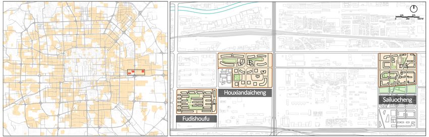
470                     W. XU, X. HUANG AND G. KIMM

the early time of this century. In 2008, procedural modeling and ABM were
aggregated by Aschwanden (2014) as a synthetic tool. To realize ABM in the 3D
digital dimension, Huang, White and Burry integrated Virtual Reality with ABM in
2018, simulating and visualizing pedestrian behaviors in urban environments with
immersive design experience (Huang et al., 2018). Instead of conducting highly
detailed ABM simulation in building scale analysis, this research utilized PedSim
to investigate walkable permeability in the neighborhood scale and proposes future
strategies for modifying neighborhood walkability.

3. Methodology
3.1. PERMEABILITY AND ASSESSMENT
Generally defined as the degree to which an urban form permeates the publicly
accessible space, permeability has been identified as one of the essential aspects
of walkability, together with safety, footpath quality, land use mix, density, and
climate (Marshall 2005; Ewing and Handy 2009; Pafka and Dovey 2016). Its
measurements relate to the ease of movement through a targeted urban area
and the diversity of travel choices. Therefore, this research selected two types
of movements to assess permeability in the neighborhood’s scale. The first is
named through-movement, representing the potential for pedestrians outside the
neighborhood to travel through the community and to access the public facilities
and landscape resources inside and surrounding the neighborhood. Second,
the type of movement by which pedestrians living inside the neighborhood can
access directly to public amenities around the community can be defined as
to-movement. In this mixed measurement system, convenient and diversified
through-movement and to-movement for pedestrians represent a neighborhood
with good permeability.

3.2. ABM PEDESTRIAN SIMULATION
As described above, we have proposed a two-tier pedestrian simulation through
PedSim. The location of public transit nodes, public facilities around the targeted
closed compound, and the gates of surrounding communities were firstly set as
the start-points and end-points for the simulation of through-movement. Public
amenities and green space resources within the gated compound were marked as
the targets that could be shared for pedestrians traveling through the community.
Following a similar logic, we then set the location of each residential building’s
entrance as the start-point and set the surrounding public amenities as the end-point
for the simulation of to-movement.
    To evaluate the permeable pedestrian network under different degrees of
gatedness, we use the cumulative density of agent path trajectories as an indication
of travel choice. Summarizing travel choice tendencies, we correspondingly
revised the position of new gates and the extent of boundary walls for further
testing the next scenario. As additional indicators for optimizing pedestrian
networks, the average travel time and distance of agents were calculated to
measure the convenience and ease of movement. These two indications facilitated
us to conduct comparative studies under various gatedness degrees within one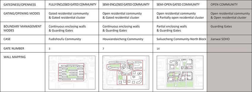
‘TEAR DOWN’ THE FENCES: DEVELOPING ABM INFORMED                         471
       DESIGN STRATEGIES FOR UNGATING CLOSED RESIDENTIAL
                          COMMUNITIES

case, suggesting a series of optimized opening strategies accordingly. Based on
the differentiation of optimized patterns among these cases, ungating strategies
were summarized for a taxonomy of gated communities.

                    Table 1. Simulation settings of the ABM system.

4. Comparative Case Study
As one of the pilot cities for China’s rapid urbanization, gated compounds have
developed rapidly in the Beijing metropolitan area in the past few decades.
In total, approximately 10300 privately secured gated communities were built
up to February 2020 (The Beijing News, 2020.2.22). Borrowing theories
from community openness evaluation, current gated communities in the Beijing
metropolitan area can be classified into four categories on a continuum from closed
to open: enclosed community, semi-enclosed community, semi-open community,
and open community (Liu, 2016; Liu et al., 2020). Enclosed communities with
guarding gates were widely constructed from the 1950s to the 1990s. The block
length of these communities is relatively long, ranging from 60 to 400 meters;
however, the number of gates on each side of the block is often limited to three.
Compared to the enclosed community type, the other three types have smaller
blocks with more gates and higher openness.
    Although the development of open communities is only in an early stage, the
Jianwai SOHO neighborhood is a successful attempt in Beijing. Designed by
Riken Yamamoto and Field Shop, the site’s existing superblock was subdivided
into nine smaller groups while arterial roads and secondary streets were introduced
into the site. The mixed road system and compound building type provide
possibilities for the pedestrian that endow a high degree of liveliness of the
community (Rowe and Kan). Despite the fact that a complete ungating strategy
like Jianwai SOHO cannot be applied to every compound, this research proposes
to maximise the openness degree while retaining the safety and privacy of each
residential model.
472 W. XU, X. HUANG AND G. KIMM
Figure 1. Distribution of gated communities in the Beijing metropolitan area and the position
of selected cases.
Table 2. Existing site conditions of selected cases.
4.1. CASE 1 FUDISHOUFU COMMUNITY
As a typical fully enclosed residential community, Fudishoufu Community has
relatively low existing permeability that inhibits through-travel and poses an
inconvenience for movements to surrounding public facilities. It occupies a huge
block covering a total area of 91937 square metres by 24 residential buildings. The
largest block length measures up to 400 metres, with only four guarding gates in
total. The existing permeability level is relatively low, inhibiting through-travel
and posing inconvenience for movements to surrounding public facilities.
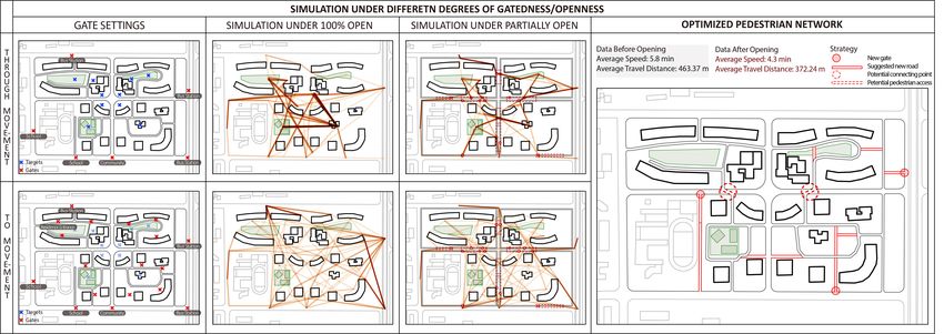
The simulation of the Fudishoufu Community was conducted under various
degrees of openness from completely open to partially open: the selected
procedures are listed below. As mentioned above, the existing gates and the
location of surrounding public transits and infrastructures were defined as the
“gate” in simulations, while the internal green spaces and public amenities were
set as the “target”. According to the cumulative density of agent path trajectories
under 100% open simulation, the tendency for travel choice was captured and
analyzed, and correspondingly, the position of new community gates and the
extent of new boundaries were designated for further simulation. Following the
same procedure, the pedestrian simulation was iteratively conducted until the
optimized pedestrian network was determined and integrated with the existing road‘TEAR DOWN’ THE FENCES: DEVELOPING ABM INFORMED 473
DESIGN STRATEGIES FOR UNGATING CLOSED RESIDENTIAL
COMMUNITIES
system.
Findings: The results illustrated denser and more connected pedestrian
networks after the removal of the gates. However, as the enclosed community
has few shared facilities and amenities, it’s not meaningful to divide the block into
small clusters. Furthermore, the building type in such communities is residential,
which requires a high level of privacy and safety. Therefore, the optimized
ungating strategy is to maximize the number of guarding gates at minimum private
cost. (Figure 2)
Figure 2. Simulation results of Fudishoufu Community and proposed new pedestrian network.
4.2. CASE 2 HOUXIANDAICHENG COMMUNITY
The Houxiandaicheng Community is located on Baiziwan Road in Chaoyang
District, covering 206300 square metres. Different from Fudishoufu Community,
it contains diverse building types, including residential, office, and commercial.
The neighborhood is divided into four groups with separating roads that are open
and connected to the city network. Compared with the traditional airtight enclosed
residential areas around, the Houxiandaicheng Community is a progressive step
towards openness in the design of Chinese urban communities.
Findings: The existing permeable level of Houxiandaicheng Community is
better than case 1, which is consistent with the research results by Jane Jacobs that
short blocks relate to a better interconnected pedestrian network (Jacobs 1961,
pp.178-186). However, the simulation indicates the need to increase walkable
connection between four residential groups. Specifically, a viable ungating
approach for semi-enclosed communities is to improve permeability between
groups by setting more gates and adding potential connecting pedestrian access
above or below ground. (Figure 3)474 W. XU, X. HUANG AND G. KIMM
Figure 3. Simulation results of Houxiandaicheng and proposed new pedestrian network.
4.3. CASE 3 SAILUOCHENG COMMUNITY-NORTH BLOCK
Located at a distance of 1.2km from the Houxiandaicheng Community,
Sailuocheng Community has a higher degree of openness with block-oriented
planning. The division of the internal clusters of the Sailuocheng Community
can be regarded as a model of the “small blocks, dense road network” promoted
by the CPC. The entire residential area consists of four rectangular areas arranged
in a north-south direction, and each area is divided into three to five groups of
mixed-use buildings with underlying commercial facilities. Under that condition,
the simulation of this case focused on the optimization of existing pedestrian
networks and the selective relocation of enclosing walls.
Findings: The planning modes of the Sailuocheng Community are close to
a completely open community. Correspondingly, its existing permeability is the
best among the three cases, which send a positive signal that a reasonable opening
of gated communities can indeed have positive impacts on the urban pedestrian
system. According to our simulation results, only a small number of guarding
gates and enclosing walls need to be removed or relocated. (Figure 4)
Figure 4. Simulation results of Sailuocheng Community and proposed new pedestrian network.
According to simulation results of three ungating scenarios, the ease of‘TEAR DOWN’ THE FENCES: DEVELOPING ABM INFORMED 475
DESIGN STRATEGIES FOR UNGATING CLOSED RESIDENTIAL
COMMUNITIES
movement has been improved to varying degrees with various opening strategies,
indicating the potential and significance to develop specific opening approaches
for different types of private secured neighborhoods.
5. Discussion and Conclusion
As discussed above, there is a striking difference in walking accessibility after
compound gates have been completely opened and the enclosing walls have
been removed. This is a positive indication that opening communities’ internal
road networks to the city can promote sharing public service facilities and green
space resources, building a harmonious and unified neighborhood environment.
However, wholescale and arbitrary removal of guarding gates and enclosures is
unacceptable, which may give rise to a new urban conflict of property rights and
safety issues. Thus, it is prudent to determine the ungating strategy for different
types of gated communities at minimum political and legal cost.
Compared with conventional studies on the walkability of gated communities,
this paper presents a novel research approach by establishing the two-tier
pedestrian movement modeling through ABM, investigating changes in
permeability among multiple opening scenarios, and informing corresponding
patterns for Beijing’s ungating urbanity. According to our research findings,
different types of gated communities have obvious differentiations in the degree
and mode of opening.
For the fully enclosed gated community type, building types inside the
compounds are mostly residential buildings, which in and of themselves are
inappropriate to be opened or shared with the outside of the community. Resources
in these communities that may be of interest to the general public are limited
and mostly green space resources. Specifically, our research has shown that the
impactful ungating strategy for these gated compounds is to have more gates and
more dynamic pedestrian networks, so as to facilitate walkability for pedestrians
living in- and outside the compound.
Necessitating a different approach, the extant morphology of semi-enclosed
and semi-open gated community types is division into smaller clusters than
enclosed communities. Their internal road networks have correspondingly
multiple layers and are partially connected with the urban road network system.
Building types in these communities are more diverse and vertically compound,
including community schools, local centers, surrounding community shops,
and underlying commercial facilities. Ungating tactics for these compounds
concentrated more on optimizing the pedestrian networks between sub-clusters
to enhance the public utilization of shared amenities.
With the aid of computational simulation, this research demonstrates that
road network typologies with varying degrees of openness have an influence
on pedestrian travel choice. In investigating the potential pedestrian access of
ungated compounds, we seek to increase the communities’ permeability and
walkability by suggesting alternative internal and external road network design
options. However, this study has the potential for future extensions in both
diversity and accuracy. For example, the neighborhood-level permeability study476 W. XU, X. HUANG AND G. KIMM
concentrated more on investigating walking patterns and road networks without
including spatial design at the building scale. Moreover, a more delicate road
network could be developed, separating the cycling network from the pedestrian
network. Considering that, we are now proposing a finer pedestrian network of
micro permeability based on this research, offering a more pragmatic opening
scenario for Beijing urban renewal.
References
Alfonzo, M., Guo, Z., Lin, L. and Day, K.: 2014, Walking, obesity and urban design in Chinese
neighborhoods, Preventive medicine, 69, S79-S85.
Arthur, W.B.: 2018, The economy as an evolving complex system II, CRC Press.
Aschwanden, G.: 2014, Health and Place: an analysis of the built environment’s impact on
walking behavior and health, Ph.D. Thesis, ETH Zurich.
Ewing, R. and Handy, S.: 2009, Measuring the unmeasurable: Urban design qualities related to
walkability, Journal of Urban design, 14(1), 65-84.
Glasze, G., Webster, C. and Frantz, K.: 2004, Private cities: Global and local perspectives,
Routledge.
Le Goix, R.: 2005, Gated communities: Sprawl and social segregation in Southern California,
Housing studies, 20(2), 323-343.
Grimm, V., Berger, U., Bastiansen, F., Eliassen, S., Ginot, V., Giske, J., Goss-Custard, J., Grand,
T., Heinz, S.K. and Huse, G.: 2006, A standard protocol for describing individual-based and
agent-based models, Ecological modelling, 198(1-2), 115-126.
Hillier, B., Penn, A., Hanson, J., Grajewski, T. and Xu, J.: 1993, Natural movement: or,
configuration and attraction in urban pedestrian movement, Environment and Planning B:
planning and design, 20(1), 29-66.
Huang, X., White, M. and Burry, M.: 2018, Design Globally, Immerse Locally, Learning,
Adapting and Prototyping–CAADRIA, Beijing, 1, 473-482.
Jacobs, J.: 2016, The death and life of great American cities, Vintage.
Kitazawa, K. and Batty, M.: 2001, Pedestrian behaviour modelling, Environment and Planning
B: Planning and Design 2001, 28, 321-326.
Kohler, T.A., Gumerman, G.J. and Reynolds, R.G.: 2005, Simulating ancient societies,
Scientific American, 293(1), 76-84.
Liu, X.: 2016, A Study on the Opening Mode of Open Residential Districts in Beijing and the
Feedback, 2016 China Urban Planning Annual Conference Proceedings, Shenyang, China.
Low, S.M.: 2001, The edge and the center: Gated communities and the discourse of urban fear,
American anthropologist, 103(1), 45-58.
Lynch, K.: 1984, Good city form, MIT press.
Macal, C.M. and North, M.J.: 2005, Tutorial on agent-based modeling and simulation,
Proceedings of the Winter Simulation Conference, 2005., 14-pp.
Osaragi, T.: 2004, Modeling of pedestrian behavior and its applications to spatial evaluation,
Proceedings of the Third International Joint Conference on Autonomous Agents and
Multiagent Systems-Volume 2, 836-843.
Pafka, E. and Dovey, K.: 2017, Permeability and interface catchment: measuring and mapping
walkable access, Journal of Urbanism: International Research on Placemaking and Urban
Sustainability, 10(2), 150-162.
Penn, A. and Turner, A. 2002, Space syntax based agent simulation, in M. Schreckenberg and
S.D. Sharma (eds.), Pedestrian and Evacuation Dynamics, Springer-Verlag.
Porta, S. and Renne, J.L.: 2005, Linking urban design to sustainability: formal indicators
of social urban sustainability field research in Perth, Western Australia, Urban Design
International, 10(1), 51-64.
Ronald, N., Sterling, L. and Kirley, M.: 2007, An agent-based approach to modelling pedestrian
behaviour, International Journal of Simulation, 8(1), 25-38.‘TEAR DOWN’ THE FENCES: DEVELOPING ABM INFORMED 477
DESIGN STRATEGIES FOR UNGATING CLOSED RESIDENTIAL
COMMUNITIES
Sun, G., Webster, C. and Chiaradia, A.: 2018, Ungating the city: A permeability perspective,
Urban studies, 55(12), 2586-2602.
Talen, E.: 2002, Pedestrian access as a measure of urban quality, Planning Practice and
Research, 17(3), 257-278.
Wu, F.: 2005, Rediscovering the ‘gate’ under market transition: from work-unit compounds to
commodity housing enclaves, Housing studies, 20(2), 235-254.
Xu, M. and Yang, Z.: 2009, Design history of China’s gated cities and neighbourhoods:
Prototype and evolution, Urban Design International, 14(2), 99-117.You can also read