The 40 Days Train Greenway
←
→
Page content transcription
If your browser does not render page correctly, please read the page content below
The 40 Days Train Greenway
They say that this railway, also called the Negrín Line, was built during the Civil War in
just forty days to supply Madrid, then under siege by Franco’s troops.

It was a strategic railway with a fleeting life; today part of its route provides an escape
from nearby Madrid and a pleasant walk or bike ride through the farmland southeast of
the city.

TECHNICAL DATA

       CONDITIONED GREENWAY

From the Tajuña river lowlands to the river Tajo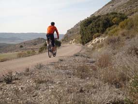
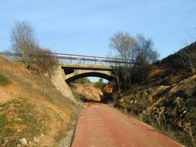
LOCATION

Between Carabaña and Estremera
MADRID

Length: 14 km

Users:

Type of surface:
Asphalt

Natural landscape:
Countryside and moorland in the southeast of Madrid. Tajuña Vegas and Carrizales
Cuenca del Tajo. Cut gypsum.

Cultural heritage:
Church Estremera, Mills Tajuña

Infraestructure:
Greenway with many trenches and two overpasses

How to get there:
Carabaña: Bus Argabús
Estremera: Bus Ruiz

Conection:
Madrid: 52 Kms.from Carabaña

Cartografía:
Militar Maps of Spain. Scale 1:50.000
Sheets 139, 171 y 172
DESCRIPTION
Km. 0 / Km. 4 / Km. 7 / Km. 12
Km 0
There are two ways to get to the start of
the 40 Day Train Greenway, developed
by the Autonomous Community of
Madrid. One on foot, by bike, or by
wheelchair from the Tajuña Greenway,
which forms a continuation of the 40 Day
Train Greenway (together they total 63
kilometres). The other way to arrive is
from Carabaña, a rural town famous for
its medicinal waters. Beside the M 204
road you can still see the remains of the
various facilities that grew up around the saline springs: the baths, the bottling plant
(now a youth hostel), and the attractive Chávarri electricity plant built on what was
once a flour mill. As we leave Carabaña, about 200 m from the town centre the road
which goes to Estremera crosses the river Tajuña over a historic 16th century bridge
and, immediately afterwards, also crosses the Tajuña Greenway. We join this Greenway
(on our left) and 300 m further on the red tarmac identifying the trail divides. The left
hand lane, belonging to the Tajuña Greenway, continues to make its way through the
Tajuña river lowlands as far as Ambite, while the right hand lane, part of the 40 Day
Train Greenway, starts to climb. Halfway up, the trail turns sharply to the right and joins
the original route of the 40 Day Railway.
Climbing upwards, our Greenway makes
its way along the mountainous slopes
which confine the Carrizales stream,
whose scant (sometimes non-existent)
waters, bordered by reed beds and
deciduous trees, wind between small
plots of land planted with cereals, vines
and vegetables. We are in an area of
rugged, solitary beauty, a landscape
ever awaiting spring when it can show
itself off in its best light and surprise us with
its aromas and flowers. In order to make
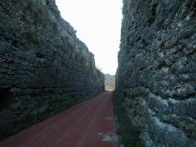
headway over such a difficult terrain, it was necessary to dig a series of cuttings which
cleave the hills of soft marl, limestone, clay or gypsum, revealing their multicoloured
layers. And on a sunny day you might want to hold out your hand to catch the sun
glinting off the mirrors of crystallized gypsum in the cuttings.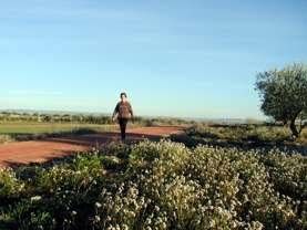
Km 4

And as if that wasn’t enough, the birds nesting in these cuttings take flight at dusk,
offering walkers and cyclists a spectacular sight. When the silhouette of the San Juan
Bautista Church (km 3,5) comes into view on the horizon, the Greenway meets the M
221 road to Valdaracete. and runs parallel to it for a short time. At km 4.5 the road takes
its leave of the Greenway and we return to the peace and quiet of before. From here
the red trail continues to ascend the Carrizales stream lowlands, now broad and gently
rolling and mostly under the plough for cereals, but dotted here and there with pine
and oak groves. The only movement comes from partridges and rabbits.

Km 7

At the underpass under the M 221 road
(km 7) we reach the end of the Carrizales
stream lowlands. Here the incline, too
steep to be tackled directly, forces the
railway to make a 180º turn, taking our
route out of the lowlands and into an
open landscape dominated by cereal
crops. At a strategic halfway point we
reach the rest area (km 8.2) where the
road to Valdaracete, the Greenway,
and the Cañada Real Soriana Oriental, a
drovers’ road where there are a number
of information boards, all meet. After the rest area the route passes through a cutting
dug into reddish clay. In this cutting we finally pass over the watershed between the
Tajuña valley and the river Tajo basin; we switch from the tributary to the mainstem river,
and from climbing to descending.

Km 12

                                            The rolling countryside which drops down
                                            into the Tajo basin takes us to an olive
                                            grove which stretches as far as the town
                                            of Valdaracete, whose name comes
                                            from the Arabic Val Dar Az-Záit, meaning
                                            “valley of the house of olive oil”. At km 12
                                            the trail reaches the M 221 road. The
                                            original route of the railway, which we
                                            never regain, crosses the tarmac and
                                            becomes a rural track. Meanwhile, the
                                            Greenway itself continues to lose height
                                            as it runs alongside the road between
olive groves and dryland crops. Two kilometres further down (km 14), the Greenway
reaches its end in the town of Estremera, very close to the regional border with the
Castilla La Mancha Autonomous Community.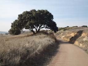
MAPS

PROFILE
RAILWAY HISTORY

The railway line, which was popularly known as the 40 Day Railway, only operated for a
brief but intense period during the Spanish Civil War. Its route connected Torrejón de
Ardoz with Villacañas, providing a railway link between besieged Madrid and the
Republican held Levante coast,along tracks that were out of range of Franco’s
howitzers.Its name reflects the haste with which this line was built, after the battle of
Jarama cut the Madrid-Alicante railway line. This primitive railway line, which was also
called the Negrín Line after the Republican minister who launched the project, barely
outlasted that sad civil conflict.

Once hostilities had ceased, the section from Torrejón to Tarancón (which includes the
stretch which has now been converted into our Greenway) was dismantled almost
entirely: only the first section, from Torrejón to Mejorada, was saved to provide access
to a sugar plant at La Poveda. The Santa Cruz de la Zarza to Villacañas section was
rebuilt to provide commercial services. The route was improved and stations were built
and it was finally reopened in 1954, before closing down definitively a little over 10 years
later.

INTERESTING DATA

       1. Festivals and holidays
       2. Accommodation
       3. Eco-tourism
       4. Managing Authority
       5. Town Councils
       6. Emergencies
       7. Coaches & buses

Festivals and holidays

Carabaña
Easter
Live representations of the Passion of Christ

September 14
Cristo de la Paz y la Salud

December 13
Fiestas patronales for Santa Lucía
Valdaracete
September 14
Fiestas patronales for Cristo del Ecce Homo

Estremera
First weekend in October
Fiestas patronales for Virgen de la Soledad y el Santísimo Cristo Sepultado

Note: The term 'fiestas patronales' refers to a local festival held in honour of the patron
saint of the town or village

Accommodation

Carabaña
Balneario Aguas de Carabaña
Tel. 639 174 335

Casa Rural del Encargado de Aguas de Carabaña
Tel. 91 323 77 20

Casa Rural del Guarda. Aguas de Carabaña
Tel. 91 323 77 20

Estremera
Hostal El Rincón de Higuerlop
Tel. 91 872 16 56
www.higuerlop.com

Casa Rural La Botica.
Tel. 699 21 98 09
www.laboticacasarural.com

Pensión El Convento
Tel. 91 872 15 94

Brea de Tajo (a 4km de Estremera)
"La Casa del Polvorista"
Tel. 609 71 36 70 / 91 894 09 89
www.lacasadelpolvorista.com

El Zumaque
Tel. 91 872 10 13

Eco-tourism

Aranjuez-Comarca de las Vegas Rural Development Association
Tel. 918 929 062. www.comarcalasvegas.es
Tourist Information for the Community of Madrid
Tel. 902 100 007. turismo@madrid.org / www.madrid.org

TOURIST OFFICES IN THE COMMUNITY OF MADRID:
Tourist Office - Duque de Medinaceli
Tel: 91 369 70 70 - 91 369 70 71 – 91 369 70 72
Tourist Office - Estación de Chamartín
Tel: 91 315 99 76
Tourist Office - Estación de Atocha
Tel: 91 528 46 30
Tourist Office - Aeropuerto Barajas Terminal Internacional T1
Tel: 91 305 86 56
Tourist Office - Aeropuerto Barajas Terminal Internacional T4
Tel: 91 333 82 48

Intermunicipal Commonwealth for the South-West of the Community of Madrid
www.turismo-misecam.com

Aranjuez-Comarca de las Vegas Development Association (ARACOVE)
Tel. 91 892 19 28 www.aracove.com

Managing Authority

Dirección General de Carreteras
Belén de Diego
Comunidad de Madrid
c/Orense, 60
28020 Madrid
Tel. 91 580 28 18
e-mail: belen.dediego@madrid.org
http://www.madrid.org

Town Councils

Carabaña
Tel. 91 872 10 13

Estremera
Tel. 91 872 16 48
www.aytoestremera.org

Valdaracete
Tel. 91 873 95 90

Emergencies

EMERGENCIES: Tel. 062
Coaches & buses

Empresa Argabús
Tel. 91 871 25 11
www.argabus.com

Empresa Grupo Ruíz
Tel. 91 680 33 15
www.gruporuiz.com

LINKS

www.madrid.org
Página Oficial de la Comunidad de Madrid. Información sobre los pueblos y otras rutas
cercanas a la Vía Verde.

www.turismomadrid.es
Página Oficial de la Sociedad Pública Turismo Madrid, S.A.
You can also read