THE DESIGN GUIDE (DRAFT) - Supplementary Planning Document SOUTH DOWNS LOCAL PLAN PUBLIC CONSULTATION JULY 2021
←
→
Page content transcription
If your browser does not render page correctly, please read the page content below
THE DESIGN GUIDE (DRAFT)
Supplementary Planning Document

SOUTH DOWNS LOCAL PLAN
PUBLIC CONSULTATION JULY 2021
.

THE DESIGN GUIDE
Supplementary Planning
Document

South Downs National Park
Authority
South Downs Centre
North Street
Midhurst
West Sussex
GU29 9DH

01730 814810

© Crown copyright and database rights 2019 Ordnance
Survey 100050083
CONTENTS iii
CONTENTS
8. PARKING & SERVICES................................ 32 14.1 PLACE MAKING..............................................63
8.1 PARKING ....................................................32 14.2 PUBLIC ART.....................................................63
8.2 SERVICES AND ANCILLARY STRUCTURES ......35 14.3 INTERNAL SPACE AND ACCESS
PART 1: INTRODUCTION.................................. 4 1.4 DENSITY...........................................................13 STANDARDS .....................................................64
9. GREEN INFRASTRUCTURE........................... 38
PREFACE.......................................................... 4 1.5 LEGIBILITY AND STREET HIERARCHY....................14 9.1 CONSERVING AND ENHANCING GREEN 14.4 ENVIRONMENTALLY SUSTAINABLE
INFRASTRUCTURE (GI) .......................................38 DESIGN ..........................................................64
HOW TO USE THIS GUIDE................................ 5 1.6 PERIMETER BLOCKS ..........................................14
1.7 ACTIVE FRONTAGES ..................................14 9.2 TREES .........................................................39 15. DARK NIGHT SKIES ............................ 65
NAVIGATION............................................................5
1.8 THE COUNTRYSIDE/SETTLEMENT EDGE .......15 9.3 SUSTAINABLE DRAINAGE ............................40
GOOD DESIGN IN THE SOUTH DOWNS............ 6
NATIONAL PARK PURPOSES AND DUTY......................6 2. CHARACTER............................................... 16 9.4 GREEN ROOFS AND WALLS ........................42
APPENDICES.................................................. 67
NATIONAL GUIDANCE .............................................6 2.1 ENHANCING LOCAL CHARACTER ...............16 9.5 ORNAMENTAL PLANTING ...........................43
APPENDIX A: OTHER IMPORTANT DESIGN
SOUTH DOWNS LOCAL PLAN...................................6 2.2 RESTORING POSITIVE CHARACTER ..............17 10. RESIDENTIAL AMENITY............................. 44 GUIDANCE.................................................... 67
SOUTH DOWNS NATIONAL PARK DESIGN 3. DEVELOPMENT IN CONSERVATION AREAS.. 18 10.1 PRIVATE GARDENS ....................................44 THE NATIONAL PLANNING POLICY FRAMEWORK....67
PRIORITIES................................................................6 10.2 COMMUNAL GARDENS..................................45 CONSERVATION AREA APPRAISALS.........................67
4. HOUSEHOLD EXTENSIONS......................... 19
DEFINITION OF LANDSCAPE.....................................7 10.3 BALCONIES....................................................45 VILLAGE DESIGN STATEMENTS.................................67
4.1 ROOF EXTENSIONS TO EXISTING RESIDENTIAL
DEFINITION OF LANDSCAPE-LED APPROACH TO BUILDINGS ......................................................19 10.4 PRIVACY AND DAYLIGHT ...........................45 OTHER SDNPA GUIDANCE......................................68
DESIGN....................................................................7
4.2 FRONT, SIDE AND REAR EXTENSIONS TO 11. BOUNDARIES.......................................... 46 DEVELOPMENT BRIEFS ............................................68
OTHER IMPORTANT DESIGN GUIDANCE............ 7 EXISTING RESIDENTIAL BUILDINGS .....................20
11.1 RESIDENTIAL BOUNDARIES ........................46 MASTERPLANS/DESIGN CODES..............................68
SDNPA PARTNERSHIP MANAGEMENT PLAN...............7 5. DEVELOPMENT TYPE.................................. 22 11.2 EDGE OF COUNTRYSIDE BOUNDARIES ......47 DESIGN & ACCESS STATEMENTS.............................68
NEIGHBOURHOOD PLANS........................................7 5.1 SINGLE DWELLINGS ...................................22
11.3 PUBLIC BOUNDARIES TO NON-RESIDENTIAL CONDITIONS & RESERVE MATTERS APPLICATIONS....68
OTHER LOCAL GUIDANCE.........................................7 5.2 FARMSTEAD DEVELOPMENTS.............................23 DEVELOPMENT.......................................................48 OTHER LOCAL DESIGN GUIDANCE..........................68
5.3 RURAL HOLIDAY ACCOMMODATION.................24 11.4 PUBLIC OPEN SPACE BOUNDARIES .................48 DESIGN REVIEW PANEL...........................................68
PART 2: DESIGN PROCESS................................ 8 5.4 SHOP FRONTS..................................................24
12. MATERIALS.............................................. 49 APPENDIX B: BACKGROUND TO DESIGN
5.5 NON-RESIDENTIAL DEVELOPMENT.....................25 12.1 BUILDING MATERIALS ................................49 PROCESS FOR LARGER OR MORE SENSITIVE
LANDSCAPE-LED APPROACH TO DESIGN IN
PRACTICE........................................................ 8 5.6 MULTI-RESIDENTIAL DEVELOPMENT.....................26 DEVELOPMENTS............................................. 69
12.2 SURFACE MATERIALS .................................54
SMALL SCALE DEVELOPMENT ..................... 8 6. SCALE....................................................... 27 1. EVIDENCE GATHERING.......................................69
13. ARCHITECTURAL DETAIL............................ 57
6.1 GRAIN.............................................................27 2. ANALYSIS...........................................................69
LARGER SCALE DEVELOPMENT.......................... 9 13.1 ARCHITECTURAL STYLES AND
6.2 MASSING ..................................................27 PROPORTIONS .................................................57 3. LANDSCAPE STRATEGY.......................................70
PART 3: DESIGN GUIDANCE........................... 11
13.2 ROOFS .....................................................58 VISION...................................................................71
7. PUBLIC REALM........................................... 28
7.1 RURAL HIGHWAY DESIGN ...........................28 13.3 WINDOWS ..............................................59 4. CONCEPT..........................................................71
1. LAYOUT..................................................... 11 5. SKETCH DESIGN.................................................71
7.2 STREETS .....................................................29 13.4 ENTRANCES AND DOORS ........................60
1.1 LANDSCAPE STRATEGY.....................................11
7.3 PUBLIC OPEN SPACE (POS)................................30 6. MASTERPLAN......................................................71
13.5 CHIMNEYS ...............................................62
1.2 ACCESS AND PERMEABILITY..............................12
7.4 PLAY SPACES....................................................31 APPENDIX C: QUALITY OF ROUTES................. 72
14. SOCIAL AND ENVIRONMENTAL
1.3 ORIENTATION ...........................................12
7.5 NATURAL SURVEILLANCE...................................32 SUSTAINABILITY............................................ 63 GLOSSARY (UNFINISHED).............................. 72
RELEVANT FOR SMALL SCALE DEVELOPMENTS
4   PART 1: iNTRODUCTION

                           PREFACE
                           To be allowed to develop at all in the National Park           We thank everyone who has helped create this Design
                           is a privilege. Mediocre design proposals will not be          Guide and commend it to all those with an interest in the
                           acceptable. New development should be an opportunity           South Downs National Park.
                           to enhance the beauty, wildlife and cultural heritage of
                           the South Downs National Park for future generations as
                           well as to achieve great place making. New development
                           should capitalise on the wonderful living and working
                           environment that the National Park already provides so
                           that it contributes to the creation of an even better future
                           for people and wildlife.

                           Part of what makes the National Park such a special
                           place is the variety of significant landscapes (including
                                                                                          Ian Phillips
                           townscapes), from the western downs on the edge
                                                                                          Chair of South Downs National Park Authority
                           of Winchester to the iconic coast at the Seven Sisters

PART 1:
                           and everything in between, including historic villages
                           and market towns. This document stresses that new
                           development must respect and build on the National
                           Park’s diverse, distinctive landscapes and townscapes;

INTRODUCTION
                           celebrate the unique sense of place found in them; and
                           must reject ‘anywhere’ design.

                           This Design Guide Supplementary Planning Document
                                                                                          Alun Alesbury
                           was adopted by the National Park Authority in xxxxx
                                                                                          Chair of Planning Committee
                           and contains guidance on how the Authority expects
                           new development to adhere to high standards of design
                           quality.

                           Planning should generate net gains for the quality of
                           our built and natural environments. Simply achieving
                           ‘no harm’ is not acceptable in the National Park where
                           the statutory purpose is to conserve and enhance the
                           essential character of the landscape (which includes the
                           built environment and the cultural heritage of the area).

                           In order to do this, we need to set out clear expectations.
                           This is what this document does. It sets out a clear
                           process and what our expectations are.
PART 1: iNTRODUCTION 5
HOW TO USE THIS GUIDE
1.1 This document is an adopted Supplementary Planning 1.4 Technical terms are explained in the Glossary and
Document, which is a material consideration in the indicated with an orange G like this .
G
determination of planning applications. It builds on Local
Plan design policies and provides guidance to applicants Scope of guidance
on a range of design issues relevant to new development. 1.5 This document is relevant to both residential and
non-residential development in the National Park and
NAVIGATION will influence SDNPA responses to consultations on
1.2 The structure of this document: developments just outside the National Park boundary.
Design guidance relevant to householder developments
Part 1 is the Introduction and single dwellings in Part 3 can be found by following
Part 2 sets out the Design Process the National Park the use of this graphic .
ordinarily expects development schemes to take from
inception to completion. Area specific guidance
Part 3 sets out the Design Principles expected to guide 1.6 This document does not provide guidance on what
development proposals in the National Park. For each is appropriate in design terms for specific areas or
issue in Part 3, numbered points within blue boxes places within the National Park. Part of the inherent
distil key design expectations. quality of the National Park is its patchwork of diverse
1.3 While this document can be printed out in either places and landscapes. It puts the onus on applicants
this A3 or the A4 version, the online version contains to demonstrate a thorough understanding of their local
numerous links in orange font to other parts of the landscape (including townscape) and for this to inform
document to ease navigation, like this. Links to other the development design.
documents and websites are in green font like this.
6 PART 1: iNTRODUCTION
GOOD DESIGN IN THE SOUTH
climate change. (see Section 14.4 and the Sustainable
Design quality is not just about what a development
Construction SPD).
scheme looks like, important though that is. It is a much
DOWNS
wider concept that includes making places that work
STRATEGIC POLICY SD5: DESIGN
well for people and wildlife, which are robust and
1. Development proposals will only be permitted where
adaptable, while responding to existing local character
they adopt a landscape led approach and respect
and identity.
the local character, through sensitive and high
NATIONAL PARK PURPOSES AND 1.11 The 2021 National Design Code will be available
quality design that makes a positive contribution to
to help guide the production of design codes for new
DUTY To achieve good design in the National Park the
the overall character and appearance of the area.
development in an area (such as for a village design applicant will need to demonstrate an understanding
1.7 The 2010 Government Vision for the National Parks, The following design principles should be adopted
statement) or for a large development site in the National of the site and its context, and that consideration has
emphasises the statutory National Park Purposes and as appropriate:
Park. been given, in a logical way, to how the development
Duty (fig 1) and the 1995 Environment Act requires a) Integrate with, respect and sympathetically
l-designed pla
can respect and respond positively to that context. This
all relevant authorities to have regard of them. The
e l complement the landscape character by ensuring
Aw ce logical approach to design is explained further in this
Purposes and Duty need to be uppermost in the minds of development proposals are demonstrably
document.
applicants and designers when considering proposals informed by an assessment of the landscape
for new development. Where there is an irreconcilable an Cont C 1.13 Much of the design guidance in this document context;
esp ext
conflict between them, statute requires greater weight be Lif
acts as an interpretation of what the SDNPA expects in b) Achieve effective and high quality routes for
h
e
applied to Purpose 1. es
I
a
Made to last Enhances the
terms of design process and design principles for new
at
people and wildlife, taking opportunities to
de
ra
surroundings
c
ur
development, but the emphasis will always be on the
nt
1.8 Assessments of design quality will be made with connect GI;
m
so
ity
ct
Re Attractive and quality of the outcomes.
Cli
reference to the National Parks’ Purposes and Duty and resilient distinctive c) Contribute to local distinctiveness and sense
er
Purpose 1 in particular. This puts the onus on applicants of place through its relationship to adjoining
Homes and
buildings
SOUTH DOWNS NATIONAL PARK
B u il t fo r m
A coherent
to demonstrate how they will conserve and enhance Functional, healthy
and sustainable
pattern of buildings, spaces and landscape features,
DESIGN PRIORITIES
development
natural beauty, wildlife and cultural heritage. including historic settlement pattern;
Mixed and
Accessible and
easy to move 1.14 Preservation and enhancement of the National d) Create high-quality, clearly defined public and
Purpose 1: To conserve and enhance the natural beauty, integrated around
Park’s built heritage is critically important to this Authority,
t
private spaces within the public realm;
en
wildlife and cultural heritage of the area.
Us
em
Enhanced
and will always be a prime consideration in the design e) Incorporate hard and soft landscape treatment
es
Safe, social and
ov
and inclusive optimised
Purpose 2: To promote opportunities for the M of any development that might affect it. This means that which takes opportunities to connect to the wider
Pu
understanding and enjoyment of the special qualities of sp blic ure the design of any new development in the National Park landscape, enhances GI, and is consistent with
ace
s Nat
the National Park by the public. Co y will be expected to demonstrate that it is responding
m m u nit
local character;
to existing local character and identity, and that the
Duty: To seek to foster the social and economic f) Utilise architectural design which is appropriate
heritage, local history and culture of the area are being
wellbeing of the local communities within the National Fig. 2: The National Design Guide 10 design and sympathetic to its setting in terms of height,
valued.
Park. characteristics massing, density, roof form, materials, night and
1.15 Even more importance is attached to preserving day visibility, elevational and, where relevant,
Fig 1: The National Parks’ Purposes and Duty and enhancing the character and appearance of those vernacular detailing;
SOUTH DOWNS LOCAL PLAN areas that have been designated as Conservation g) Provide high quality, secure, accessible, and
1.12 The Local Plan, which sets out strategic, Areas. Specific guidance on this can be found in 3.0 where possible, integrated storage for general
NATIONAL GUIDANCE development, management and site-specific policies for Development in Conservation Areas. and recycling waste, heating fuel, and transport
1.9 The National Planning Policy Framework says the National Park, requires a ‘landscape-led’ approach
1.16 Equally, the Authority sees the connected themes of related equipment;
that achieving high quality places and buildings is to design for development in the National Park due to its
conserving and enhancing biodiversity; enhancing and
fundamental to the planning and development process intrinsic landscape quality.
linking green infrastructure; and bringing people closer to
and that development that is not well designed should
The unique character of the many diverse places within nature as a significant design priority for all types of new
be refused, especially where it fails to reflect local
the National Park must always be the starting point for development. See in particular Section 1.1 Landscape
design policies. The 2021 update also emphasises that
good design. All applicants should Strategy and Chapter 9.0 Green Infrastructure
development within the setting of National Parks should
be located and designed to avoid adverse impacts. demonstrate that they understand what this consists of 1.17 The Authority is also very committed to new
for their site. Several policies in the Local Plan touch on development meeting high sustainable development
1.10 The 2019 National Design Guide sets out broad
design quality, and while the Local Plan should be read standards, both mitigating and adapting to predicted
principles for design quality, which are distilled in 10
as a whole, Policy SD5 is the main design policy.
characteristics shown in figure 2.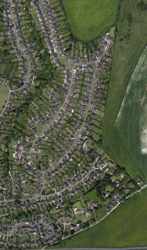
PART 1: iNTRODUCTION                   7
                                                             DEFINITION OF LANDSCAPE-LED
    h) Provide high quality outdoor amenity space
       appropriate to the needs of its occupiers or users;   APPROACH TO DESIGN                                            OTHER IMPORTANT DESIGN
                                                                                                                           GUIDANCE
    i) Ensure development proposals are durable,              Design, which is strongly informed by understanding
       sustainable and adaptable over time, and               the essential character of the site and its context (the
       provide sufficient internal space to meet the needs    landscape), creates development which speaks of its
       of a range of users;                                   location, responds to local character and fits well into
    j) Give regard to improving safety and perceptions        its environment. It needs to conserve and enhance the        SDNPA PARTNERSHIP                                              OTHER LOCAL GUIDANCE
       of safety, and be inclusive and accessible for all;    natural beauty, wildlife and cultural heritage of the area   MANAGEMENT PLAN                                                1.21 Applicants, developers and individual home
       and                                                    and create sustainable and successful places for people.     1.19 The 2020-2025 SDNPA Partnership Management                builders need to be aware of other important local
    k) Have regard to avoiding harmful impact upon, or                                                                     Plan (PMP) sets out how the Authority and its many             guidance that should inform their scheme designs and
       from, any surrounding uses and amenities.                                                                           partners aim to maintain the National Park’s Special           may influence how they are assessed by the planning
                                                                                                                           Qualities. It has 10 key outcomes and 57 policies,             authority.

DEFINITION OF LANDSCAPE                                                                                                    many of which affect the design aspirations for new            1.22 Conservation Area Appraisal and Management
                                                                                                                           development and well-designed schemes can help                 Plans have been written for many of the Conservation
 ‘An area perceived by people whose character is the                                                                       contribute to meeting them. Two of the key themes in the       Areas in the National Park and Village Design Statements
 result of the action and interaction of natural and/or                                                                    PMP are Climate Change and Nature Recovery, which              for many communities.
 human factors.’ (European Landscape Convention)                                                                           have informed the guidance in this document.
                                                                                                                                                                                          1.23 The SDNPA has produced guidance in the form
1.18 Landscape is much wider in scope than simply
                                                                                                                                                                                          of Development Briefs for specific allocation sites and
the green elements. It consists of everything you see                                                                      NEIGHBOURHOOD PLANS
                                                                                                                                                                                          Technical Advice Notes and Supplementary Planning
and experience, including buildings and townscape                                                                          1.20 Neighbourhood planning gives local communities
                                                                                                                                                                                          Documents for specific issues.
in settlements, which comes together to produce the                                                                        the power to shape development in their area.
distinctive sense of place the South Downs National Park                                                                   Neighbourhood Development Plans (NDPs) can set out             1.24 Further information on all this guidance and
was designated to conserve and enhance.                                                                                    design criteria, local materials, etc., which are also to be   other forms of design guidance that may be relevant to
                                                                                                                           considered when designing a development. They are a            applicants can be found in Appendix A of this document.
                                                                                                                           good source of local historic, landscape and community
                                                                                                                           information that should influence designs. Applicants are
                                                                                                                           strongly advised to check whether their site is covered by
                                                                                                                           an NDP. Over 50 NDPs are either adopted or are being
                                                                                                                           prepared in the South Downs National Park, and these
                                                                                                                           are all shown on the designated neighbourhood areas
                                                                                                                           map.

                                                             Fig 3: A selection of some of the short-listed schemes in
                                                             the 2019 SDNPA Design Awards
8 PART 2: DESIGN PROCESS
LANDSCAPE-LED APPROACH TO
DESIGN IN PRACTICE
2.1 In practice, the following is required: Consistency – the design of the development should
be driven by the analysis of the evidence about the
Proportionality – the evidence required to describe
site and this should be demonstrable.
the character of the site and its context will depend
on the sensitivity of the site and the scale of the And, for larger schemes in particular:
development. Multi-disciplinary teams working together from the very
Iteration – reviewing and changing layouts/designs start toward achieving a scheme ‘vision’ and using the
to explore alternative ways to generate the most gains evidence of the character of the site and its context to
from a site. inform all design stages.
SMALL SCALE DEVELOPMENT
PART 2: 2.2 A single dwelling development (or other domestic- 3. Landscape
DESIGN PROCESS
scale developments) should follow a logical design The development needs to set out what it will achieve in
process. See also Case Study 4 which shows how a terms of biodiversity net gainG, Ecosystem Services and
landscape led approach can be applied to a farmstead green infrastructure and this helps determine where the
conversion. The Authority strongly recommends building should sit on the plot.
applicants engage with pre-application discussions with
officers, as this can save time and avoid abortive work. 4. Concepts
The design of the development should ideally explore
1. Evidence Gathering
different options with the pros and cons explained which
For a single house, an understanding of the site and can be part of the discussion with the planning authority.
its context is very important. This would include a brief This is particularly important in the most sensitive
character study of local buildings, streets, materials and locations.
native planting, the site levels, how the site drains, views
of the plot from the public spaces, the history of the site 5. Detail Design
and its context and road, track and path connections
Once the right concept design is agreed, this can be
around the site.
worked up into a more detailed set of designs.
The relevant local plan, neighbourhood plan and village
design statement policies and design guidelines should 6. Consultation and Engagement
also be collated, where available. The design may benefit from early consultation with
the local community, e.g. the parish council and any
2. Analysis other individuals or groups that may be affected by the
The evidence is used to form a series of opportunities and development. Some development proposals may benefit
constraints for the design of the house development. from appearing before the SDNPA Design Review Panel.
Vision
What should the end result achieve and how will it meet
the National Park’s Purposes and Duty?
PART 2: DESIGN PROCESS   9

LARGER SCALE DEVELOPMENT
2.3 Larger schemes may need to follow a process similar     development could be arranged on the site. At this stage,
to that shown in figure 4. The following summarises the     it is legitimate to try out different options and assess
stages in figure 4, but more detail on this is found in     them against each other in terms of pros and cons with
Appendix B.                                                 reference to the Design Policy SD5; the relevant Design
                                                            Principles set out in Part 3 of this document; the high level
1. Evidence Gathering                                       aspirations of the Vision; and their consistency with the
The landscape evidence (including townscape) is             Landscape Strategy.
required to demonstrate a thorough understanding of
the site’s context. A design that is fully landscape-led    5. Sketch Design
is unlikely to be possible without this, as the lack of     Once the best concept design has been chosen and
understanding of local character is likely to result in a   ideally been subject to pre-application discussion, the
scheme that will not be rooted in its location and risks    proposals can be worked up into sketch design details.
                                                                                                                            Fig 4 The suggested Landscape-led design process for larger scale development
being ‘anywhere’ development. Applicants should gather
all evidence for the site and its context (the ‘landscape   6. Masterplan
baseline’). For larger and more sensitive sites, the        Masterplans, more appropriate for the largest                   10. Design Review
chosen study area should respond to evidence and            development schemes, set out the arrangement of                 Design Review of proposals and finished schemes inform
best practice as found in Guidelines for Landscape and      buildings, streets and access as well as incorporating the      the design process for both current and future schemes.
Visual Impact Assessment 3). Local knowledge as found       landscape strategy.
in Neighbourhood Plans and Village Design Statements
should also be used.                                        7. Detail Design
                                                            All development proposals will ultimately result in detail
2. Analysis                                                 design drawings and specifications that set out exactly
The evidence collated needs to be analysed to provide a     how the development should be built. This will be in the
set of development constraints and opportunities for the    form of plans, elevations and sections and, in sensitive
design of the scheme.                                       landscapes, possibly three dimensional, virtual or real
                                                            models.
Vision
The applicant is encouraged to set out the vision for the   8. Management Plans
development. This should include high level aspirations     Management Plans should be drawn up to show that
which equate to a best practice response to the Design      the ongoing maintenance and future custodianship of
Policy SD5 and the purposes and duty of the National        the developments are well considered and adequately
Park.                                                       resourced.

3. Landscape Strategy                                       9. Consultation and Engagement
The landscape strategy is a critical part of the design,    From an early stage and continuing as the design is
which is a direct response to the analysis of the           worked up, the applicant should engage with planning
landscape evidence, local policies and the vision.          officers and relevant stakeholders in the interests of
                                                            achieving the best design solution and minimising the
It must inform subsequent stages of the design process
                                                            likelihood of obstacles to the smooth passage of any
which need to refer back to the landscape strategy
                                                            planning application. In more sensitive cases, the draft
principles. The landscape strategy should set out the
                                                            vision should be shared with the local community to
landscape capacity for the site.
                                                            encourage useful feedback.
4. Concepts                                                 Proposals on more sensitive sites may need to go before
The landscape strategy and the Vision for the site          the SDNPA Design Review Panel so that they might
should lead to different ideas or concepts for how the      review them and offer advice.
10      PART 2: DESIGN PROCESS

Fig. 5: An illustration of Design Stages 1-5 for a medium sized residential development, showing how each stage forms a milestone in the design narrative and builds on the previous stage

                                                                                                                    3                                                                                          5
           1                                                   2                                                                                                     4
                                                                                                               Landscape                                                                                     Sketch
        Evidence                                             Analysis                                                                                              Concept
                                                                                                                Strategy                                                                                     Design

   Historic mapping

                                           Opportunities

   Ecological surveys

                                                                                               Landscape Strategy                               Concept                                      Sketch Design

   Zone of Theoretical
                                           Constraints
   Visibility in Landscape
   Visual Impact Analysis

   Local Guidance
1. LAYOUT 11
1. LAYOUT
3.1.0.1 The design of the layout of a new development
is a synthesis of many factors, opportunities and
constraints, addressed in this chapter. In the National
Park the landscape strategy is a key driver for how the
layout should evolve. Access to and through the site and
the orientation of buildings all impact on the layout. In
larger development the build density, street hierarchy
and the application of the good practice of perimeter
blocks and active fronts all influence the layout further.
The particular issue of how development addresses the
countryside edge also affects layout. The critical impact
of car parking on layout is covered separately in 8.1.
1.1 LANDSCAPE STRATEGY
Ecology
The landscape strategy should help determine the
e.g. conserving important biodiversity assets, or,
PART 3:
capacity of the site and hence the appropriate
enhancing existing assets, or, connecting to those
developable area for the development.
beyond the site.
3.1.1.1 The landscape strategy stage is a key part of the
Movement networks: routes and nodes
DESIGN GUIDANCE
design process, which has a crucial impact on the layout
e.g. the likely access points into the site and
of the design proposal. This applies even to the smallest
connection points for both people and wildlife beyond
single building development schemes (see fig 4). The
the site boundaries.
landscape strategy is needed at the start of the design
See 1.2 Access and Permeability.
process and this will help inform the developable area.
Settlement pattern and edges
3.1.1.2 The following elements can affect the scheme’s i.e. what works for the site and is characteristic of
site layout: the area, including settlement edges and buffers to
Geology and soils countryside.
e.g. how traditionally, homes have arranged Perceptual Qualities
themselves loosely bordering heathland e.g. key views, vistas and gateways to settlements all
Topography influence overall layout and, retaining and enhancing
e.g. ‘hidden village’ character of some villages, landscape character, e.g. experience of hedgerows,
or, need to avoid developing higher ground due to watercourses.
unacceptable visual impacts 3.1.1.3 Environmental health issues such as noise
Water and contaminated land and existing services such as
e.g. development may need to avoid high flood risk overground cables or underground pipes, can also affect
areas and, sustainable drainage strategy may dictate the landscape strategy and site layout.
layout of roads and open space
History and built heritage
e.g. respecting the course of ancient routes, or, views
of historic buildings, or restoring characteristic field
patterns, or, avoiding putting development too near
archaeological remains.12 1. LAYOUT
LANDSCAPE–LED HINT
1.2 ACCESS AND PERMEABILITY Permeability 1.3 ORIENTATION
3.1.2.2 Permeability describes how well connected
Old Malling Farm housing development, a. Opportunities for enhancing movement networks for The orientation of buildings and streets should take
a site is for people and wildlife. (see also 9.0 Green
Lewes people and wildlife should be maximised following account of:
Infrastructure). Larger sites should seek to avoid
identified desire lines.
development becoming an obstacle to identified desire a. what is locally characteristic.
b. Vehicular access should prioritise provision for non-
linesG. b. microclimate, the need for natural surveillance, solar
motorised user movement and the ease of access
3.1.2.3 Vehicular permeability on larger sites is important collection, key views and vistas.
for people with pushchairs, wheelchairs etc. and
disabilities should also be considered. to prevent inherently inefficient cul-de-sacs that cause c. topography and significant existing features.
c. The character and treatment of all vehicular access longer driving distances and wasteful turning areas for
3.1.3.1 The orientation of buildings and streets is
points and roads should aim to reduce adverse cars and service vehicles and so alternative vehicular
influenced by several factors. New development should
impacts on the landscape and avoid highway access points and direct routes are supported as a
take account of what is locally characteristic such as
dominated character. general principle.
buildings stepping up, or streets following contours and
d. Access roads and routes should be in accordance 3.1.2.4 Non-motorised routes usually need to be more buildings parallel to or at angles to a road.
with the guidance document Roads in the South direct than vehicular routes. Where possible, people
3.1.3.2 Wide fronted buildings facing onto the street, or
Downs. should be given the opportunity to use direct and
repeated gabled ends of buildings, or a mix of both, may
e. The location of access routes through the site should attractive routes on foot or by bicycle, e-bicycle and
be local characteristics that a new development could
Respond to important views from the site to help retain ensure that there is space within the developable scooter, responding to natural desire lines and as an
usefully continue, to help its integration into a street or
local identity areas for viable blocks. alternative to using the car for journeys below 3km.
settlement.
The landscape strategy ensures that the layout of f. Where possible, larger residential developments 3.1.2.5 The quality of routes is essential to ensure that
3.1.3.3 Orientation can have beneficial effects on
open space between buildings will retain key views of (20 homes and above) should have more than one they are well used. Appendix C sets out how the quality
microclimate. The direction of prevailing winds in
Hamsey Church vehicular access to avoid large cul-de-sacs and to of routes can be assessed under the headings:
exposed areas may influence the orientation of buildings,
improve permeability.
Connected, Convenient, Comfortable, Convivial and minimising elevations that face the wind. This can be
g. Good permeability needs to be balanced with the Conspicuous. managed through good landscape design which can
need for security and crime prevention.
also assist with the energy efficiency of buildings, through
h. Permeability should take account of the need for the e.g. shelter belts or providing summer shade to reduce
quality of routes and for natural surveillance. overheating, or green roofs.
i. The routes and the amenity of existing public rights
3.1.3.4 PV or solar water collection, or passive solar
of way should be respected.
heat, may influence the orientation of buildings or roofs
to help maximise solar collection, although in the most
Access
visually sensitive locations, PV may not be appropriate
3.1.2.1 The design of the access to the site and (see Mitigating Climate Change in 14.3).
development within it, fulfils a practical function as well
as contributing an important part of the development’s 3.1.3.5 The need for natural surveillance of public realm
character. areas and to protect private amenity, can also influence
Fig 1.1: Poorly connected (a) and well connected (b) new the orientation of buildings and streets. The orientation
Existing routes of public rights of way should be street layout of buildings and streets, other routes and public realm
respected and only in justified circumstances will a may be influenced by the desire to preserve important
diversion be acceptable. The amenity of such routes also views, create attractive vistas or make the most of existing
needs to be respected. landmark features.1. LAYOUT 13
1.4 DENSITY LANDSCAPE–LED HINT
Development density should aim for efficient use of land Designed density should respond
while also: appropriately to area’s characteristic density
a. integrating new development by using a similar
grain and density to that which is locally
characteristic or is appropriate to the site’s location;
b. considering scale, height, volume, site coverage and
distance from and effect upon, adjacent buildings;
c. not being at the expense of: privacy, good internal
PV / solar water panel does not maximmise
movement of the sun throughout the day
space standards, sufficient private garden or
communal open space and adequate access;
d. enhancing GI, providing multi-functional SuDS Fig 1.4 Edge of village site density illustration
Fig 1.2: Buildings in East Meon are often at angles to the
30° (where possible) and avoiding the loss of
road 30° south
environmental quality or significant existing
Developable area = 50%, GI = 50%
landscape features;
PV / solar water panel does not maximmise PV / solar water panel facing 30 degrees of
Net density of developable area = 30dph
movement of the sun throughout the day south maximises the movement of the sun
e. allowing for a transition to less intense development, Gross density of whole site = 15dph
where it borders the countryside and where that
New development density (66dph) matches local
context
reflects the local character.
Town centre >80dph
30°
30° south
30°
30° south Gross and Net Densities 50-80dph
3.1.4.1 In practice, in the National Park, gross densitiesG 14 1. LAYOUT
1.5 LEGIBILITY AND STREET 1.6 PERIMETER BLOCKS 1.7 ACTIVE FRONTAGES 3.1.7.1 Non-residential active fronts at ground level can
be created by locating main entrances, indoor reception
HIERARCHY New developments should aim to respect existing or
a. Active frontages and particularly ground floor areas (and shop windows), and outdoor meeting places
Development should promote good legibility in the achieve new perimeter block layouts unless not feasible near those entrance zones on the street. Where possible
elevations, should address streets and spaces.
following ways: or not locally characteristic. and appropriate, cafes and restaurants should explore
b. Buildings on corner plots should be active on both
sides. the potential for extending out into public realm areas to
a. clear route hierarchy;
3.1.5.3 The classic layout for promoting good help animate those spaces.
b. strong and logical building layout and massing; c. Blank walls or elevations with only non-active
permeability and legibility is the perimeter block. room windows should not face the public realm if
c. consistent choice of materials;
Residential perimeter blocks make a clear distinction possible.
d. architecture reflecting building use and emphasising between private gardens behind the buildings (promoting
main entrances; d. Residential streets should have: frequent doors
good security and privacy) with public streets in front (as
and windows from active rooms; bay windows;
e. use local landmarks and key views; in figs 1.9 and 10.7). Strong building lines help provide
porches; front gardens.
f. retention of key distinctive features. good passive surveillance and activity on the street side.
e. Animation can be enhanced with balconies in
3.1.5.4 In more rural locations, an irregular block layout apartments and oriel windows above the ground
3.1.5.1 Legibility describes the ease with which visitors
may provide a more appropriate ‘organic’ character. floor projecting out into the street
can orientate themselves and find their way around a
site or an area. Routes in larger developments should be 3.1.5.5 Non-residential building in perimeter blocks f. Non-residential development can enliven street
arranged into a hierarchy to help people make sense of should also have their public side with the main elevations with: generous fenestration (unless this
where they are. entrance(s) on the street side with servicing to the rear. conflicts with dark night skies policy); entrances;
pavement terraces; shop windows.
3.1.5.2 Strong and logical building layouts, such as
Opportunities for outside sitting and Locate main entrances, shop windows,
perimeter blocks help make places legible as does eating places should be explored reception areas and outdoor meeting
spaces on the street
the use of massing, clear architectural signalling of
entrances, consistent use of materials, the retention and
Fig. 1.10 Non-residential active frontages
enhancement of existing features (such as mature trees,
water features or buildings), use of topography, public
open space and distinctive architecture and incorporation
of attractive views.
Vista of landmark
Fig 1.7: Regular perimeter blocks in Lewes Unavoidable blank walls
need detailing / planting
Local landmark
Avoid blank sides, which
can create opportunity
for surveillance
Perimeter blocks
Corner buildings can
be local landmarks
Fig 1.9: Corner buildings need to be active on both sides
Clear hierarchy
of routes
Fig 1.8: Organic-shaped perimeter blocks in East Meon
Consisten building
materials
Fig 1.6: The elements of a legible development showing
a route hierarchy1. LAYOUT 15
1.8 THE COUNTRYSIDE/SETTLEMENT and the existing settlement. This can be assisted by
the enhancement of green infrastructure links from the
EDGE
countryside and into the new development.
a. A new settlement edge should reflect the best
locally characteristic examples of settlement edges
Fig 1.12
with the countryside.
b. Repeating unsympathetic twentieth century
development settlement edge character should be
avoided.
c. New development should generally be set back
from the countryside edge, allowing a GI buffer
(unless this conflicts with local character),
d. Where possible, new development should address Fig 1.15: Development fronts onto a lane that defines the
the countryside directly and not turn its back onto it, countryside boundary on the southern edge of Friston
unless this is not locally characteristic.
e. Where new development cannot front onto Figs 1.11 and 1.12: The loose, organic settlement
countryside, low key rural character boundary edge and the incursions of wooded landscape into the
settlement from the countryside, typical of the Western
treatments will be expected,
Weald, is demonstrated in Selborne.
f. Good quality development should not need to be
screened from rural views but rather should aim to
become an attractive part of the landscape.
Fig 1.14
g. Screening may be required for unavoidable
development that could cause visual harm both
inside and outside the National Park
h. Green infrastructure links from the countryside into
the new development and, where appropriate,
across it, should be accommodated. Fig 1.15
Fig 1.16: An example of over intense development on the
i. New settlement edges need to look both ways, countryside edge with no transition (Midhurst).
responding to the countryside while also knitting
into the existing fabric of a settlement. Fig 1.13, 1.14 and 1.15: An example of a more abrupt
relationship with the countryside edge at Friston, more
typical of the eastern downland.
3.1.8.1 More modern, mostly twentieth century, Fig 1.12: Views from countryside of the backs of
development often failed to create an appropriate properties facing the high street.
settlement edge and this has created harmful impacts on
the wildlife and beauty of the National Park and on the
character and sense of place of the area (see figs. 1.16,
1.17, 1.18 1.20). These poor precedents of countryside
edge settlement should not be repeated.
3.1.8.2 A key objective is to avoid a suburbanisation
of the countryside edge with inappropriate ‘anywhere’
building types and layouts and an over intensification, Fig 1.14: Long, well-vegetated rear gardens back onto
exacerbated by car-domination viewed from the public the countryside on the eastern edge of Friston.
realm.
3.1.8.3 As buildings have always been an integral part
of the National Park landscape, the objective is not
to generally screen off new development but to make
sure that it integrates well with both the countryside16 2. CHARACTER
Existing public footpath network
Existing ditch incorporated
as SuDS feature through site
Green infrastructure/ POS
2. CHARACTER
2.1 ENHANCING LOCAL served where it is clear that the local heritage, history
and culture are being responded to.
CHARACTER
Character might be enhanced with either:
a. The character of a place should be identified and
described. New development needs to conserve new buildings which have a traditionally-inspired style
and enhance this character. or
New PRoW linking
with high quality contemporary architecture which
to existing network
b. The use of standard house types that take no
Existing native hedges and trees
retained and enhanced account of local character, bad imitation of complements the existing character.
traditional design or simply replicating mediocre Equal care will be needed in designing spaces between
design in the locality will not be acceptable. buildings that are attractive, have a clear purpose, are
New homes are locally character-
istic in terms of scale, settlement
Homes directly address the
countryside distinctive, and complement and enhance the best of the
pattern, architectural detail and 3.2.1.1 The National Design Guide indicates that two of
materials existing character of the area.
the 10 characteristics of good design are that it should
Fig 1.19: Example of good countryside edge principles respond to existing local character and identity, and 3.2.1.6 The following figures show examples of the many
value heritage, local history and culture. different areas with positive characters in the National
See also 11.2 Edge of Countryside Boundaries. Park.
Fig 1.17: Rear gardens backing onto countryside often 3.2.1.2 The conservation and enhancement of the
lead to garden waste dumping which harms biodiversity existing character of an area is an essential requirement
and can kill mature trees and/or lead to encroachment. LANDSCAPE–LED HINT for making an attractive and successful place. Applicants
Some twentieth century developments fail will need to demonstrate that they understand the site
to respond well to the countryside edge and context and can describe its character. They should also
Layout should not make pressure do not follow a landscape-led approach to be able to show how they have been influenced by the
for future development phases
more likely design. local building traditions, use of materials, etc., which
characterise the part of the National Park in which their
proposal is situated.
Building form and
materials not locally
3.2.1.3 The South Downs Landscape Character
characteristic
Assessment (LCA) 2020 for the whole Authority area
Development buildings and Local Landscape Character Assessments, covering
and access roads too
close to countryside edge all parts of the National Park, provide invaluable local
Fig 2.1: West Sussex farmstead, Sullington
information on landscape character, which should be
supplemented by a finer grain understanding of character
on the scale of the site and the more immediate context.
Rearsideofpropertyandgaraging
viewed from countryside
3.2.1.4 More stringent restrictions on the type and nature
Suburban type fencing
inappropriate on Development has been allowed to run hard up of development in Conservation Areas are set out in
settlement edge
against countryside boundary with no space for section 3.0 and are also often contained in Conservation
Fig 1.18: Poor countryside edge layout vegetative transition. Area Appraisals prepared by the Authority. Some locally
Unprepossessing building design fails to reference specific guidance such as Village Design Statements may
the best of local architecture and materials or be available and should be used to inform design in
enhance the beauty of the National Park. those areas.
Suburban character fences, back garden sheds and 3.2.1.5 Respecting character will not be achieved
clutter create visual harm in this location. successfully with an excessive variety of architectural
styles within new development, as this results in a
contrived approach. Character and identity will be best Fig 2.2: Open countryside with scattered settlements2. CHARACTER 17
3.2.1.7 Each site has its own character, which, with
LANDSCAPE–LED MINI-CASE STUDY
2.2 RESTORING POSITIVE
green field sites in particular, may largely consist
The architecture of the new Fridays housing
CHARACTER
of natural landscape elements and features. New
development should work with those elements and scheme in East Dean has been influenced a. Opportunities for new development to enhance
celebrate that character. Figure 2.6 shows how the way by the following aspects of local building character should be taken.
that new development is designed can enhance local character:
b. Understanding of the landscape character (including
character, which in this case includes the topography of townscape) of the site and beyond, needs to be
the site. demonstrated. The character of the development
shou;ld be clearly informed by this.
c. In larger developments the design should avoid
inappropriate repetition and the feeling of ‘an
anywhere place’.
Fig 2.3: The Market Square, Petersfield 3.2.2.1 Where the immediate surroundings of
development sites exhibit very little existing positive
character, (often, for instance, where there has been
loosely controlled twentieth century development) the
Existing E Dean character emphasis will be on producing new high quality and
distinctive places and restoring positive character.
roof pitch
materials 3.2.2.2 A site cannot have ‘no character’. There will still
be aspects of the site character (such as its topography
Fig 2.6: New homes in West Dean step down the slope scale & form
emphasising and enhancing this aspect of the site’s or its history) and the best of the local character beyond
character. the immediate vicinity, which can be used to inspire and
create positive development.
3.2.2.3 Where there is no immediate positive built form,
inspiration should be taken from the nearest positive
Fig 2.4: Victorian streets, Lewes examples, depending on what is most appropriate to the
site in question, using character studies such as
villages in the near vicinity or
other settlements in the same landscapes, e.g. another
spring-line village or another chalk valley settlement or
from the best of town street development
Larger developments
3.2.2.4 In larger developments, some repetition may
be appropriate, (such as where a traditionally inspired
New development
terrace of similar houses is being deliberately produced
window style and timber frames as one coherent whole) as well as providing some design
exposed rafter feet consistency across a development. Some variety, in built
form, layout, style and materials may be necessary and
Fig 2.5: Medieval town centre character in Midhurst front doors & canopies
distinct ‘character areas’ may be appropriate. These
locally characteristic boundary structures must be rooted in the different site characteristics, such
as existing positive development, topography, views out,
natural features etc.
3.2.2.5 The design should avoid both excessive
repetition, which leads to monotony, and too much
variety that can be discordant and appear arbitrary.18 3. Development in Conservation Areas
Nor should it create the feeling of a scheme that has not
3. DEVELOPMENT IN
responded well to its context, where development fails to
enhance local character or provide a series of attractive
places. The result of these negative approaches is an
‘anywhere’ development which feels like an alien add-on
to a village or town. CONSERVATION AREAS
LANDSCAPE–LED MINI-CASE STUDY Meon Valley. Each one is special in its own way and
Development proposals should:
The new Dundee House older persons’ their design needs will also vary accordingly.
a. preserve or enhance the character and appearance
housing scheme in Midhurst is landscape led. 3.3.0.3 Under the Listed Buildings and Conservation
of the conservation area
The net effect is a development that enhances Areas Act 1990, conservation areas are designated to
the character of this part of the town. b. avoid massing or building height which is overly
recognise and protect the special interest and character
dominating for the site and its context.
to be found and enjoyed within them. Their purpose is to
c. relate or respond positively to the built heritage celebrate these characteristics and ensure that they are
predominating in the Conservation Area, so ‘preserved or enhanced’.
that the new development can properly be seen
as preserving or enhancing the character and 3.3.0.4 The broad guidance in this document applies
appearance which led to the area’s designation. to all parts of the National Park, including conservation
areas and areas within the setting of listed buildings and
d. respond to key views into, through and out of the
ancient monuments. As with development everywhere
Conservation Area.
in the National Park, design will need to demonstrate a
e. reference the building traditions of the settlement
landscape-led approach.
and, where appropriate, fit sympathetically into the
Site in 2019
existing streetscape. Heritage Assessment
f. avoid the use of uPVC windows, fascia cladding or 3.3.0.5 For any development in conservation areas,
Prominent site. Poor immediate character: petrol other assertively synthetic materials, even if attempts including works to existing buildings or structures, there
station, supermarket car park, 20th century houses are made to emulate traditional details. will always be particular considerations relating to the
and police station g. if traditional materials are proposed, observe local need to preserve or enhance the Conservation Area’s
craft traditions and avoid, short-cuts, such as flint- architectural or historic character and appearance. For
block construction. this reason, all potential development in, closely adjacent
h. Where possible, remove buildings or structures to, or affecting the setting of a Conservation Area and
whose aesthetic appearance are harmful to the similarly any proposed works to a listed building, historic
overall character and appearance for whose parkland/garden or scheduled ancient monument, or
protection the area was designated. affecting their setting, requires the applicant to undertake
a heritage assessment. See SDNPA guidance on writing
3.3.0.1 The National Design Guide indicates that the first
these.
three (out of 10) characteristics of good design are that it
should: (i) understand and relate well to its site, its local 3.3.0.6 There is a natural and proper assumption that the
and wider context; (ii) value heritage, local history and overall character and appearance of a conservation area
Sketch of development 2020 culture; and (iii) respond to existing local character and should not change very significantly over time.
identity. Under the National Planning Policy Framework 3.3.0.7 However, few conservation areas are entirely
Used traditional built form and styles found in (NPPF), conservation areas are designated heritage
Midhurst (Victorian & Georgian) consistent in character within their boundaries and
assets and their conservation is to be given great weight some development or redevelopment opportunities
Urban grain and streetscape repaired in planning decisions. may be found. It is worth checking if there is a recent
Midhurst materials 3.3.0.2 There are 167 Conservation Areas in the South conservation area appraisal for the settlement as these
Simple boundary treatments reflect local character Downs National Park, ranging in size from substantial documents sometimes identify such opportunities,
parts of towns like Lewes, Petersfield, Petworth and especially if they are prominent in important street
Midhurst, through to many rural villages and settlements, scenes.
right down to a Victorian water pumping station in the4. HOUSEHOLD Extensions 19
3.3.0.8 Whatever new work is proposed, it must
4. HOUSEHOLD EXTENSIONS
respect its context and contribute to the character of the
conservation area as defined when it was designated.
3.3.0.9 For significant schemes it is advisable to seek
pre-application advice, specifically requesting the
General Principles 4.1 ROOF EXTENSIONS TO EXISTING
involvement of the SDNPA Conservation Officer.
3.4.0.1Domestic extensions must be designed to RESIDENTIAL BUILDINGS
respect the size and character of the house and the
existing character and appearance of the street and a. Dormers may not always be appropriate facing the
the wider area. The scale, massing, siting, fenestration street where this is not already locally characteristic.
and materials of any proposal are therefore key b. A dormer should not dominate the roof, but should
considerations. complement the existing features of the house, and
roof in particular, in terms of proportion, form, size,
Fig 3.3: A Grade 2 listed building refurbishment and a A poorly designed proposal can have a great impact on
position and detailing.
contemporary café extension enhance the Selbourne CA the occupiers of adjacent or nearby properties.
at the Gilbert White Museum c. Dormers should normally line up with the existing
3.4.0.2 The following guidelines indicate the issues windows, and be kept away from the ridge and
Fig 3.1: A successful preservation of the Fernhurst CA
which the Authority will take into account when deciding edges of the roof in order to provide a visual frame.
character with a side extension on the right hand end of Further advice on conservation areas can be found on
whether to grant planning permission. d. Roof lights should not protrude significantly from
a terrace. the Historic England website.
3.4.0.3 Whether the extension is at the front, rear or the roof profile and should be evenly spaced. They
See also Local Plan Policy SD15. should not dominate the roof.
side, it should be designed to be:
e. The Dark Night Skies policy may make roof
subservient in mass, bulk and form to the existing
lights difficult to accept in certain locations and if
property
acceptable, mitigation measures in line with the Dark
sympathetic to its surrounding and adjacent properties Night Skies TAN will be expected.
visually integrated with the existing building
3.4.1.1 Changes to the shape of a roof need to be
3.4.0.4 An extension which significantly alters the
carefully considered. In the case of semi-detached
shape or character of a house is not usually advisable,
properties or streets with an attractive and very uniform
the aim of the design should be to allow the house to
roof design, significant alterations to the roof are
maintain its original appearance and predominance over
Fig 3.2: The Depot, an enhancement of the Lewes CA generally unacceptable.
an extension. In other words, the extension should be
with a high quality contemporary scheme and a re-use of
subordinate to the main house. 3.4.1.2 Dormer windows can be difficult to incorporate
the existing depot building.
into a roof without adversely affecting the appearance
3.4.0.5 A number of areas have produced Village Design
of the dwelling and the street, particularly if too large.
Statements which provide local guidance on extensions.
Eyebrow dormers or mansard roof dormers may be more
3.4.0.6 As with all design in the National Park, acceptable. Where dormers or roof lights facing the
household extensions (and conversions and street are already locally characteristic, it is more likely to
refurbishments) will be expected to follow a landscape- be acceptable than where they are not.
led approach based on the landscape evidence
3.4.1.3 Where extra headroom is not required, roof
(which includes townscape and materials) albeit in a
lights offer a simple, economic method of lighting the roof
proportionate manner. Householder applications also
space. Roof lights that protrude significantly above the
need to respond to the Ecosystems Services policy SD2
roof plane are generally discouraged as they look clumsy
which is detailed in the Ecosystems Services Technical
and their size, number and positioning needs to fit well
Advice Note for Householders.
with the roof and the rest of the building.You can also read


