Urban Forestry Management Plan - City of Red Lodge - March 2018
←
→
Page content transcription
If your browser does not render page correctly, please read the page content below
City of Red Lodge
                 Urban Forestry
                Management Plan

March 2018
Theresa Whistler and Rue Freeman (Tree Committee)
City of Red Lodge Parks, Trees and Recreation Board

James Caniglia, City Planner

Jennifer Lyman, City-contracted Staff (2017 Inventory Lead)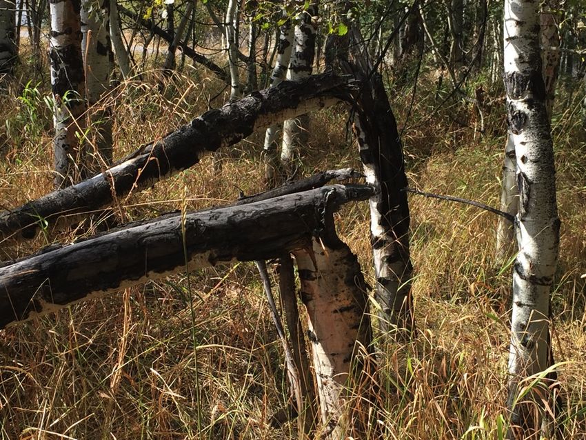
CONTENTS
Figures ………..…………………………………………………………………………………………………………………………………………. 4
Tables ……………………………………………………………………………………………………………………………………………………. 5
Executive Summary ........................................................................................................................................ 6
Chapter 1. Overview....................................................................................................................................... 7
Introduction .............................................................................................................................................................. 7
Community Tree History ........................................................................................................................................... 7
   Parks, Trees and Recreation Board ...................................................................................................................... 7
   Tree City USA ........................................................................................................................................................ 7
   Arbor Day ............................................................................................................................................................ 8
   Cost-Share Tree program ..................................................................................................................................... 9
   Northwest Energy Grants ..................................................................................................................................... 9
   Red Lodge Program-trees Summary ................................................................................................................... 10
Reference to Trees in Community Plans ................................................................................................................. 11
Soils ......................................................................................................................................................................... 12
Insects and Disease ................................................................................................................................................. 14
Chapter 2. Tree Inventory ............................................................................................................................ 15
Objectives and Limitations ..................................................................................................................................... 15
Methods ................................................................................................................................................................. 15
Inventory Summary ................................................................................................................................................ 20
   Species composition and diversity ...................................................................................................................... 21
   Diameter / Height .............................................................................................................................................. 29
   Tree canopy ........................................................................................................................................................ 31
   Condition – leaves and wood.............................................................................................................................. 31
   Condition - deadwood ........................................................................................................................................ 34
   Condition - Insects and disease .......................................................................................................................... 35
   Condition – other agents of damage/defects ..................................................................................................... 41
   Tree Maintenance ............................................................................................................................................. 45
   Stumps ................................................................................................................................................................ 47
Tree Planting Opportunities .................................................................................................................................. 49
Chapter 3. Recommendations ..................................................................................................................... 54
Tree plantings and maintenance ............................................................................................................................ 54
Natural Areas .......................................................................................................................................................... 54
Managed Areas ....................................................................................................................................................... 55
Monitoring and Evaluation ..................................................................................................................................... 56
Public Education ..................................................................................................................................................... 57
City Ordinance ........................................................................................................................................................ 58
Administration ........................................................................................................................................................ 61
Potential and Continued Tree Programs ................................................................................................................ 61
Chapter 4. Workplan .................................................................................................................................... 63
References .................................................................................................................................................... 69
Appendix A. Ordinance No. 919: Tree Regulations of the City of Red Lodge ............................................ 71
Appendix B. Preferred or Prohibited Tree Species for Red Lodge .............................................................. 77
Appendix C. Tree Disease and Insects ......................................................................................................... 83
Current insect and disease problems ..................................................................................................................... 83
  White Pine Weevil ............................................................................................................................................. 83
                                                                                                                                                                                2
Cytospora canker ............................................................................................................................................... 84
  Cooley Spruce Gall Adelgid ................................................................................................................................ 84
  Western Spruce Budworm ................................................................................................................................. 84
  Fireblight ........................................................................................................................................................... 85
  Cankers .............................................................................................................................................................. 85
  Scale ................................................................................................................................................................... 87
Potential insect and disease problems ................................................................................................................... 88
  Ash Plant Bug .................................................................................................................................................... 88
  Septoria Leaf Spot .............................................................................................................................................. 90
  Marssonina Leaf Spot ........................................................................................................................................ 90
  Spruce Beetle ..................................................................................................................................................... 90
  Gypsy Moth ....................................................................................................................................................... 91
Appendix D – Supporting Items for Red Lodge Tree Program .................................................................... 93
July 20, 2017 Article in Carbon County News ......................................................................................................... 93
Red Lodge Program Tree Listing ............................................................................................................................. 94
   Arbor Day Trees, Types and Locations ................................................................................................................ 94
   Cost-share Trees, Types and Locations ............................................................................................................... 94
   Other-grant Trees, Types and Locations ............................................................................................................. 97

                                                                                                                                                                            3
Figures
Figure 1 - MAP: Red Lodge Arbor Day tree locations ________________________________________________________ 8
Figure 2 - MAP: Red Lodge cost-share tree locations _______________________________________________________ 9
Figure 3 - MAP: NWE grant tree locations_________________________________________________________________ 9
Figure 4 - MAP: Diversity and distribution of Red Lodge "program trees" ________________________________________ 10
Figure 5 - Soils map of Red Lodge. Data from Natural Resources Conservation Service (1975) ________________________ 13
Figure 6 - Displays of ArcGIS Collector application interfaces on an iPhone_______________________________________ 16
Figure 7 - Surveyors Jennifer and Tom Lyman _____________________________________________________________ 19
Figure 8 - MAP: Extent, location and count of sites surveyed 2017 _____________________________________________ 20
Figure 9 - Tree species composition of Red Lodge public trees _________________________________________________ 21
Figure 10 - 5 most common trees in Red Lodge, 2009 vs. 2017 ________________________________________________ 21
Figure 11 - MAP: Distribution and concentrations of cottonwoods in Red Lodge __________________________________ 24
Figure 12 - Quaking aspen locations and condition of wood ___________________________________________________ 25
Figure 13 - MAP: Distribution of green ash and mountain ash trees in Red Lodge _________________________________ 26
Figure 14 - MAP: Blue spruce public tree locations by height __________________________________________________ 27
Figure 15 - MAP: Engelmann spruce public tree locations by height _____________________________________________ 28
Figure 16 - Peachleaf willow with larget DBH ______________________________________________________________ 29
Figure 17 - Distribution of inventoried trees by DBH classes ___________________________________________________29
Figure 18 - MAP: DBH distribution and location (multi-stems not included)_______________________________________ 30
Figure 19 - Peachleaf will ow with largest canopy in City survey _______________________________________________ 31
Figure 20 - Wood ad leaf condition of inventoried trees______________________________________________________ 31
Figure 21 - MAP: Distribution of City trees by condition of leaves ______________________________________________ 32
Figure 22 - MAP: Distribution of City trees by condition of wood _______________________________________________ 33
Figure 23 - Very common site of a mountain ash tree with dieback ____________________________________________ 34
Figure 24 - Percent deadwood of inventoried trees _________________________________________________________ 34
Figure 25 - Comparison of percent deadwood 2008 vs. 2017 _________________________________________________ 35
Figure 26 - Insects and diseases in City trees by percent _____________________________________________________ 35
Figure 27 – MAP: Location of public trees with wood boring insects ___________________________________________ 36
Figure 28 - MAP: Locations of Emerald ash borer insect traps 2008 (yellow) ____________________________________ 37
Figure 29 - MAP: Green ash locations at Field School Park __________________________________________________ 37
Figure 30 - MAP: Green ash trees surrounding Lutheran Church ______________________________________________ 38
Figure 31 - MAPS: Black poplars at Finn Park (left) and Rotary Park (right) _____________________________________ 38
Figure 32 - Aspen stand in decay due to untrerated cankers (left) and Rotary Park (right) __________________________ 39
Figure 33 - Hackberry nipple gall (left), poplar leaves with galls due to insect eggs (right) __________________________ 39
Figure 34 - Shoot canker and leaf spot (left), crown gall (bacterial) found on black poplar (right) _____________________40
Figure 35 - Black knot disease on chokecherry (left) and fungal conk upon a rotting mountain ash limb (right)___________40
Figure 36 - Leaf spot on quaking aspen tree (left), insect galls within canopy of poplar tree (right)____________________ 41
Figure 37 - Common damage agents/defects of 2017 inventoried trees _________________________________________ 41
Figure 38 - Common damage agents/defects of 2008 inventoried trees _________________________________________ 42
Figure 39 - Human caused (2008) vs. animal/equipment caused damage (2017) __________________________________ 43
Figure 40 - Frost crack on trunk of young tree _____________________________________________________________ 43
Figure 41 - Frost crack comparison 2008 vs. 2017 ___________________________________________________________ 44
Figure 42 - Young tree "topped" after an early snowstorm ___________________________________________________ 44
Figure 43 - Large and small trees with immediate maintenance needs __________________________________________ 45
Figure 44 - Young tree in need of cage adjustment__________________________________________________________ 46
Figure 45 - Tree that's been topped and pruned repeatedly to avoid wire line conflicts _____________________________ 46
Figure 46 – MAP: City trees with present or potential wire line conflict __________________________________________ 47
Figure 47 - MAP: 2008 Tree removal recommendations vs. stumps found in 2017 _________________________________ 48
Figure 48 - MAP: Cost-share tree locations relative to Red Lodge street trees (100 added since 2013) _________________ 49
Figure 49 - MAP: Potential tree planting sites along Red Lodge streets __________________________________________ 50
Figure 50 - Minimal urban forestry in City of Red Lodge circa 1909 – 1934 _______________________________________ 53
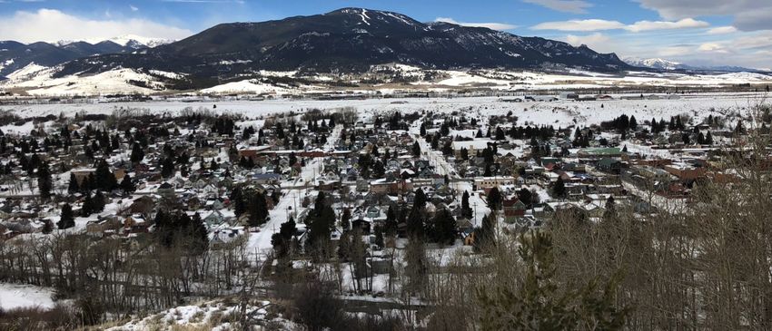
Figure 51 – View of Red Lodge's urban forest, winter 2018 ____________________________________________________ 53
Figure 52 - MAP: City-managed public trees _______________________________________________________________ 68
Figure 53 - Spruce tree terminal killed by White Pine Weevil __________________________________________________ 83
Figure 54 - Cooley spruce gall adelgid in late spring ________________________________________________________ 84
Figure 55 - Fireblight canker on mountain ash tree (photo from Grabowski 2009)_________________________________ 86
Figure 56 - Mountain pine beetle pitch tubes (left) and galleries (right) in a lodgepole pine __________________________ 86
4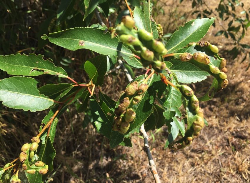
Tables
Table 1 - Current insect and disease problems known to occur in Red Lodge ______________________________________ 14
Table 2 - Data Dictionary for the 2017 Red Lodge Tree Inventory _______________________________________________ 16
Table 3 - 2017 Red Lodge Tree Inventory Counts ____________________________________________________________ 20
Table 4 - Statistics for tree DBH, height and canopy _________________________________________________________ 21
Table 5 - Tree species surveyed during 2017 Red Lodge Tree Inventory __________________________________________ 22
Table 6 - Diversity of trees species among City Parks ________________________________________________________ 29
Table 7 - Trees preferred for planting in Red Lodge, MT (Hardiness Zone 4)_______________________________________ 77
Table 8 - Tree borer species and hosts (Cranshaw and Leatherman 1999, Zeleznik et al 2005) _______________________ 89

                                                                                                                   5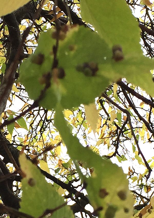
Executive Summary

A second public tree inventory was completed in 2017 as part of the effort to update the 2018 Urban Forestry
Management Plan (UFMP). The objective was to collect and analyze information on “public” trees within the
corporate limits of Red Lodge (i.e., trees on City and county-owned property including parks and street right-of-ways).
Results of the 2008 inventory suggested that public trees in Red Lodge reaching maturity lacked the recommended
species and age diversity to prevent a large loss of trees from catastrophic insect or disease epidemic that target
specific species or genus. The 2017 inventory suggests the majority of public trees are mature, although, young public
trees planted in public rights-of-way are adding greater species and age diversity to the City forest. The 2017
inventory finds that 20% of potential planting sites identified in 2008 have been filled with young trees. Continued
City tree planting programs the updated preferred tree species list (Appendix B) should further guide diversity of Red
Lodge’s urban forest.

Both young and old trees in public areas are in need of maintenance; 360 of these trees need immediate attention.
Sixty-one of the 360 are considered “high priority” and in need of pruning to remove deadwood and/or removal. Two
of the high priority trees represent a potential public safety hazard and should be addressed immediately. Forty-
seven percent of public trees that require immediate maintenance are privately owned and found within street right-
of-ways (ROWs). They are the responsibility of the adjacent property owner although that may not be known, so, it is
recommended that the City help educate property owners and residents on the need for tree maintenance and
enforce ordinance 919 where necessary.

A ten-year work plan to maintain and enhance the City’s urban forest is updated and appended (Appendix A). The
work plan suggests 1) improved communication of ordinance No. 919 to strengthen tree care, planning and
management, 2) increased tree management responsibility of the Parks Board and Public Works Department, 3) a
Citywide tree education campaign and continued cost-share and Arbor Day tree program, 4) an increased allocation
of funds toward tree care: additional funding by City taxpayers and/or from outside grant sources and 5) greater
outreach and coordination of volunteers to assist with community forestry maintenance.

Implementation of this UFMP requires monitoring, enforcement, and follow-through by all parties involved. The
UFMP serves as a strategic approach to sustaining the City’s community trees on a short and long-term basis and will
hopefully result in a healthier and safer community forest in Red Lodge.

                                                                                                                       6
Chapter 1. Overview
Introduction

Trees have long been recognized for the beauty and value they lend to our homes, neighborhoods, parks and business
areas. Not only do trees enhance and beautify our City, they also provide shade and visual screening, conserve
energy, help clean the air, store carbon, protect our rivers and streams and provide shelter for wildlife. Trees also
increase residential property value by 3.5 to 6% and up to 30% for undeveloped property (University of Washington,
1998a). They have been estimated to have an appraised value of “between $1,000 and $10,000" according to the
Council of Tree and Landscape Appraisers. The presence of trees may also positively influence consumer attitudes and
prices that shopper are willing to pay (University of Washington, 1998b & 2000).

                                      The City of Red Lodge is fortunate to be situated in a forested riparian corridor
 "The net cooling effect of a         and a climate conducive to continued tree growth. The City is also fortunate that
 young, healthy tree is
                                      many of its early community members recognized the value of trees and chose to
 equivalent to ten room- size air
                                      plant a variety of species within the parks and along the streets. The community
 conditioners operating 20 hours
                                      is now enjoying the benefits of mature trees thanks to the investment and
 a day."— US Department of
 Agriculture                          commitment of the early settlers.

                                       Today, the City continues its commitment to the maintenance and enhancement
of its “urban forest” by participating in annual Arbor Day activities, membership in the Tree City USA program, and
support for the Parks Board and Public Works Department, which plan and maintain public trees.

This Urban Forest Management Plan (UFMP) is the next step towards that commitment. This plan is intended to
provide the foundation for an ongoing program that will result in a healthier and safer community forest in Red
Lodge. It is a strategic approach to sustaining the City’s community trees on a short and long-term basis. This plan
includes background information on the history and goals of tree care for the City (Chapter 1), a baseline inventory of
public trees (Chapter 2), recommendations for future stewardship of the City’s urban forest (Chapter 3), and a work
plan and budget that provides short and long term priorities for tree care and maintenance (Chapter 4). Also included
as appendices are 1) City ordinances pertaining to trees, 2) a recommended tree list for the City, 3) information about
insects and disease present or potentially present in Red Lodge and, 4) a map showing the inventoried trees of Red
Lodge. References cited throughout the UFMP and appendices are also included and, when available, hyperlinked
websites are listed for further reading of reference materials. Actual tree inventory data for individual trees is located
and maintained in a Geographic Information System by the City of Red Lodge.

Community Tree History

Parks, Trees and Recreation Board
The City of Red Lodge established the Parks, Trees and Recreation Board (the Parks Board) originally through
Ordinance 810 and currently maintains it by ordinance No. 918 (http://cityofredlodge.net/wp-
content/uploads/2013/10/Ordinance-918.pdf). This citizen-based advisory board, appointed by the Mayor and
approved by City council, is responsible for the oversight of all City parks and public trees. The general responsibility
of the Parks Board is to identify park and tree needs. Specifically, the six-member board is to “recommend the
planting, pruning and removal of trees, shrubs and other plantings located on public property.” They are also
chartered to “maintain a list of appointed and not recommended trees for use in public rights of way. “

Funding for the Parks Board comes from the collection of resort taxes. In recent years, the Parks Board has budgeted
funds ranging from $7000-$9500 annually for public tree planting and routine or ad hoc maintenance. The public
works department also contributes resources toward the maintenance of trees. The Parks budget is annually
adjusted and supplemented assuming contributions from DNRC and Arbor Day grants.

Tree City USA
Red Lodge celebrated its 18th year membership in the Tree City USA program in 2017. The Tree City USA program,
sponsored by the Arbor Day Foundation in cooperation with the USDA Forest Service and the National Association of

                                                                                                                            7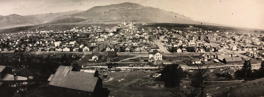
State Foresters, provides direction, technical assistance, public attention, and national recognition for urban and
community forestry programs in thousands of towns and cities. Red Lodge is one of 3,400 communities to receive this
designation nationally, one of 42 cities with the distinction in Montana.

Red Lodge continues to qualify for Tree City USA and meets the four standards established by The Arbor Day
Foundation and the National Association of State Foresters. These standards ensure that every qualifying community
has a viable tree management plan and program. To remain eligible, the City must have 1) a tree board or
department, 2) a tree care ordinance, 3) a community forestry program with an annual budget of at least $2 per
capita, and 4) an annual Arbor Day observance and proclamation.

Arbor Day
Red Lodge celebrates Arbor Day annually, usually in late May or early June to avoid cold spring conditions. A typical
day includes a gathering of Parks Board members and community volunteers to maintain or plant, stake and fence
                                                                    new trees. In 2009, sixteen people, including
                                                                    members of the Red Lodge boys & girls club,
                                                                    contributed about three hours of their time to
                                                                    plant a total of six trees. The trees (chokecherry,
                                                                    maple and elm) were planted, fertilized and
                                                                    fenced at the Carnegie Public Library, Field
                                                                    School Park and the Skateboard Park. From
                                                                    2010 to 2017, 14 additional Arbor Day trees have
                                                                    been planted around the City (Figure 1) Red
                                                                    Lodge celebrated Arbor Day in 2017 by planting
                                                                    two Tatar maples trees in cutouts on the 11th
                                                                    Street W side of the Wells Fargo Bank on
                                                                    Broadway Ave.

                                                                     A detailed listing of Arbor Day trees planted in
                                                                     Red Lodge is found in Appendix D under Arbor
                                                                     Day Trees, Types and Locations.

Figure 1 - MAP: Red Lodge Arbor Day tree locations

                                                                                                                        8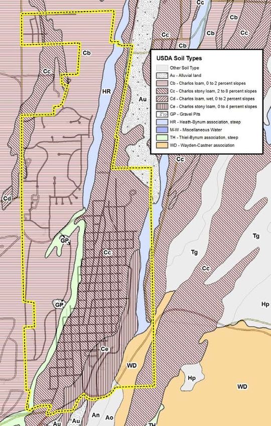
Cost-Share Tree program
Red Lodge initiated a Cost-Share Tree program in 2013 with funding from Montana Department of Natural Resources
(MTDNRC). Under the Cost-Share program a Red Lodge property owner can apply to purchase a tree from the City for
planting along a City easement or planting strip adjacent to their property. The City evaluates the proposed location,
checks for conflict with public works, plants the tree, stakes, and fences it. The landowner is responsible for all other
                                                                  care of the tree (watering, fertilizing, pruning, etc.).

                                                                 From 2013 through 2017, 100 new trees have been
                                                                 added to the Red Lodge urban forest (Figure 2).
                                                                 Twenty-two different varieties of trees comprise the
                                                                 Cost-Share offerings over the years and have led to
                                                                 increased diversity of the City’s urban forest.

                                                                 A detailed listing of cost-share trees planted in Red
                                                                 Lodge is found in Appendix D under Cost-share Trees,
                                                                 Types and Locations.

Figure 2 - MAP: Red Lodge cost-share tree locations

Northwest Energy Grants
In 2011 Northwest Energy gave 22 trees of seven
different cultivars to the City of Red Lodge
through their grant program. These were planted
throughout the City in “planting-sites” identified
during the 2008 survey. Five trees were planted
along Broadway and the rest on its side streets
(Figure 3).

NWE will make additional reimbursements to Red
Lodge for trees that are removed due to power
line conflicts. The Parks Board and City Planning
will use this money to replant height-appropriate
tree species under power lines.

A detailed listing of NWE-granted trees planted in
Red Lodge is found in Appendix D under Other-
grant Trees, Types and Locations.

                                                      Figure 3 - MAP: NWE grant tree locations

                                                                                                                         9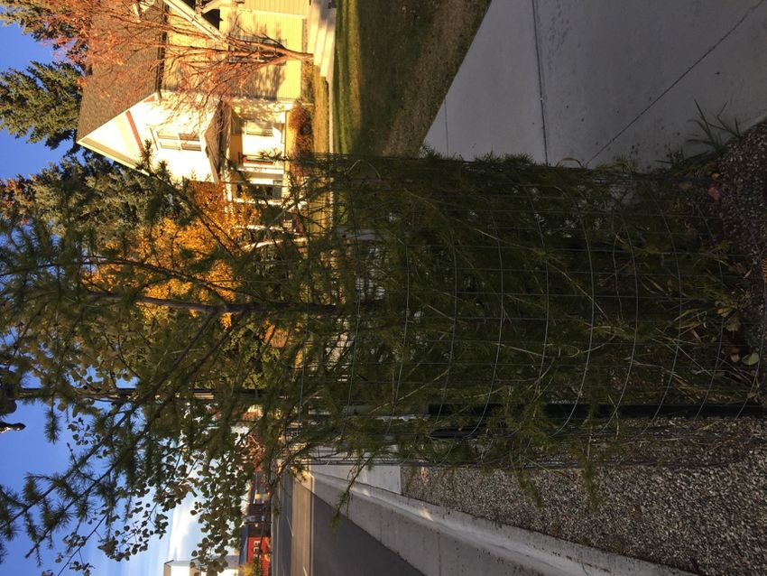
Red Lodge Program -trees Sum m ary
From 2009 to the present, a total of 141 trees including 20 Arbor Day, 100 Cost Share, and 22 Northwest Energy Grant
trees, have been planted by Red Lodge to add species and age diversity to its urban forest (Figure 4). The Red Lodge
Tree Program has managed tree planting at 25.8% of 2008 listed potential tree sites (141 trees) within public areas.
The 2008 Red Lodge tree inventory identified 546 potential planting sites and the 2017 survey identified 91 additional
planting sites to expand options for public tree planting. The City GIS and spatial data analysis is used to target
program tree locations by looking at all potential locations and their situations. Red Lodge plans to continue cost-
share and Arbor Day planting annually for the long-term as part of its mission to maintain Tree City USA status.

In addition to the City’s tree program, MT State Department of Transportation (MDT) has contributed a number of
trees and a water delivery system along Hwy 212 on the North end of City as part of the “Red Lodge 8th to Robinson”
highway improvement project (2014/2015). The City now manages these trees and those within parks and the core
business district. HWY right-of-way trees supplement Red Lodge’s urban forest and add diversity through the City’s
collaboration with MDT.

Figure 4 - MAP: Diversity and distribution of Red Lodge "program trees"

                                                                                                                   10
Reference to Trees in Community Plans
There are many guiding documents for the City of Red Lodge including the Revitalization Master Plan (1986), Trails
Plan (2006), Comprehensive Parks Plan (2015), Active Transportation Plan (2016) and the Growth Policy (2015). Most
of these documents discuss parks, recreational opportunities and scenic beauty as being important attractions of Red
Lodge. Few specifically mention the role of trees or tree management needs, but one can safely assume that trees
contribute to these attractions. Below are a few extracts from these guiding documents that directly or indirectly
reference trees.
The revitalization plan discussed landscaping opportunities in Red Lodge and said that over half of the consumers
surveyed identified “cleaning and beautifying the City with trees and flowers” as one of the most important
improvements for the City, especially along its entrances.
The trails plan mentions the importance of landscaping along trails to improve the scenic quality and experience for
people using the trails. It is assumed that such landscaping would include tree planting and/or maintenance.
The 2015 Growth Policy has a stated goal that “existing mature trees and vegetation shall be preserved while hardy,
drought resistant landscaping is encouraged” and that the City “will maintain its Tree City USA status and plan to help
care for the urban forest resource. In the climate change section, the plan states that a goal should be to “Maintain
healthy urban forests; promote tree planting to increase shading and to absorb CO2.”
Climate & Weather
Results of a Montana Climate Assessment (MCA) were released in September of 2017 by a group of Montanan
professors and research associates looking at data from MT DNRC, NOAA, USDA Forest Service, USDA – National
Agricultural Statistics Service (NASS), and the US Global Change Research Program (USGCRP). Focus of the
assessment is on Montana’s water, forests and agriculture looking at historical climate data ranging from 1950 to
2015 and future climate models from the World Climate Research Program (WCRP). The State is divided into 5 climate
divisions; Red Lodge belongs to the “South Central” region east of the Rockies.
The following summary points from the assessment of historical data between 1950 and 2015 should be considered
for urban forestry management, work plans, maintenance budgets, preferred and non-preferred tree planting and
locations:
• Annual average temperature across Montana has already risen 2.0 – 3.0O F,
• Greatest deltas in min and max temperatures found in Spring and Winter (average increase 3.9oF)
• Growing season length is extended with earlier spring and longer summer (~12 days)
• Annual precipitation averages have not changed, but winter precipitation decreased (0.9 inches) while spring
precipitation increased 1.3 – 2.0 inches.
The City may consider the following projections from the assessment for future UFMP evaluation and planning:
• Annual average temperature across Montana is expected to increase approximately 4.5 to 6.0oF by 2050
• “Earlier onset of snowmelt and spring runoff will reduce late-summer water availability in snowmelt-
dominated watersheds.”
• Precipitation is expected to increase during winter (not snowpack), spring and fall while decreasing in the
summer (especially in the South and Central regions) – maintaining annual mean precipitation overall.
• Number of consecutive dry days should remain within average ranges + or – 3 days though are likely to
present more severe droughts
The estimated annual precipitation of Red Lodge ranges from 10” to 14” for most of the City with slightly higher
amounts (15” to 24”) on steeper slopes coming off the east and west Rock Creek benches (USDA 1975), most likely
due to deposition of snowdrifts. The majority of this precipitation comes in the form of snow. The weight of high-
moisture, late spring snows often damage trees in Red Lodge, especially if deciduous trees have leafed out.
11High winds in this area can occur in any month. Winds can break or topple larger trees and damage younger saplings,
as evidenced by the fall 2007 wind event in Red Lodge and the Beartooth Mountains. Extended periods of hot, breezy
days in summer months can dry out soils and result in tree mortality. Over the past 10 years, there has been an
overall drought in the Carbon County area, resulting in increased tree mortality and insect and disease occurrence in
drought-weakened trees.
USDA winter hardiness zone for Red Lodge is shifted from Zone 4a to Zone 4b, with -20 to -25 degrees F average
annual minimum temperatures (USDA 2012). Zone maps have been revised to represent the changes due to climate
change and predict where various trees and plants may adapt well. However, almost as important to tree survival is
the microclimate conditions city-developed areas. For example, asphalt surfaces surrounding one site make it hot and
dry. But around the corner, buildings cast shadows that cut temperatures and minimize evaporation of soil moisture.
Sidewalks, curbs and gutters can drain water away from or funnel it into areas, making for either dry or over-
saturated soils. Light, wind, temperature, and soil conditions can change abruptly from one spot to another. Urban
conditions are frequently more severe for the growth of trees than in natural environments. On the other hand,
conditions could also be better due to irrigation or lack of competition.
Seasonal variation in urban areas may also be extreme compared to more natural areas. A site may be hotter in
summer and colder in winter. Or, it may be drier in the summer and wetter in the winter due to soil compaction, the
presence of paved surfaces, and snow plowing. Snowmelt runoff from roofs may coat trees in ice or encases the
ground around trees with ice. Paved areas and buildings generate heat that usually keeps temperatures warmer in all
seasons than in more natural areas; a phenomenon known the "urban heat island" effect.
Soils
Soils in the Red Lodge area provide an adequate tree growth medium. According to the Soil Survey of Carbon County
(U.S. Department of Agriculture, Soil Conservation Service, 1975), the majority of soils in the corporate limits of Red
Lodge consist of the Charlos association, a loam to stoney-loam soil that is generally well-drained on 0-8% slopes
(Figure 2). The soil generally has 110-120 frost-free days and is moderately suited for hand & mechanical planting due
to sandiness.
Steep slopes below the east bench and on the west bench below the Red Lodge golf course are classified as Heath-
Bynum association, steep soils. Steep slopes on the west bench south of 1st Street are classified as Thiel-Bynum
association, steep soils. Soil profiles in these areas are generally shallow (20” to 40”) due to underlying bedrock
outcrops. There are numerous springs discharging from these slopes and places were slumping has occurred. Native
quaking aspen and cottonwood frequently grow on wetter portions of these slopes, particularly at springs, wet areas,
and adjacent to irrigation ditches. In drier areas, tree cover consists of scattered limber pine, Douglas fir, and various
shrubs.
It is important to note that map unit and soil properties for a specific parcel of land may vary somewhat and should
be determined by onsite investigation. Site-specific concerns need to be evaluated and considered prior to making
tree planting or species selection decisions. Localized soils concerns for tree planting in Red Lodge include areas with
coal slag, compacted soils, a high water table depth, poor soil drainage, extremely rocky soils, and steep slopes. The
best indicator of soil suitability is to examine trees already growing on or near the given site and try to plant either
the same species or species that grow in similar conditions.
12Figure 5 - Soils map of Red Lodge. Data from Natural Resources Conservation Service (1975)
13Insects and Disease
Less than one percent of the estimated one million insect species on the earth are pests. An even smaller percentage
is considered forest pests. Yet, insects are capable of creating tree and fire hazards, reducing visual quality, affecting
wildlife use, and degrading watershed properties.
The urban forest of Red Lodge has a varied occurrence of insect pests. At times the damage caused by these pests
may reach levels that require no action because costs of treating are greater than the benefit gained. However, if a
pest is detected and accurately identified, steps preventing an increase in population and the ensuing damage should
be taken if possible.
Some pests, such as many of the wood-boring insects and canker-causing fungi, are opportunistic, becoming serious
problems on trees that are under considerable stress. Inadequate moisture, temperature extremes, wind or snow
damage, unfavorable soils, herbicide injury, mechanical injury and tree age may cause tree stress. These factors and
others, such as defoliating insects and diseases, often will predispose trees to opportunistic insects and diseases
(Zeleznik et al 2005). Maintaining vigorous and healthy trees suited for the location they are planted in is the best
defense against insects and disease.
Rather than provide an encyclopedic listing of all potential insect and disease problems, this tree management plan
focuses on 1) existing insect and disease problems affecting trees on City lands in Red Lodge and 2) insects and
diseases that can potentially affect the largest numbers of trees on City lands. Insect and disease problems were also
verified with arborists and a Montana DNRC urban/service forester. Table 1 is a listing of Insects and diseases known
to occur in Red Lodge trees and which species is affected. This table originated with the 2008 tree inventory and was
updated according to field observations made by the 2017 team. Insects and diseases with potential to occur in Red
Lodge are listed in Appendix C. More in- depth information, including descriptions and management options for each
listed insect or disease is also provided in Appendix C.
Table 1 - Current insect and disease problems known to occur in Red Lodge
Insect or Disease Species Affected
White Pine Weevil Spruce (Engelmann and Colorado Blue), pine species
Cytospora canker Spruce. Most damaging on Colorado and Norway species
Cooley Spruce Gall Adeigid Spruce, Douglas fir
Western Spruce Budworm Douglas fir, all true firs, spruce and larch. May be found in pines
Fireblight Apples, crabapples, mountain ash, hawthorn and roses
Cankers Poplar species (aspen, cottonwood, hybrid poplars)
Mountain Pine Beetle Most native and introduced species of pines
Green Ash, Poplar species (aspen, cottonwood, hybrid poplars), pine (lodgepole,
Scale
ponderosa, and ornamentals), willow, apple, occasionally spruce and Douglas fir
Aphids Conifers and hardwoods
Western Gall Rust Lodgepole and Ponderosa pines
Western Tent caterpillar Prunus species
Hackberry Nipple Gall Hackberry
Leaf spot Aspen and Poplars showing affectations most greatly late summer through fall
Black Knot Prunus species (evident in Red Lodge chokecherrys)
Leaf and Stem Galls Poplars,
Conks Mountain Ash
Crown Gall Prunus, Populus, Malus, Rosa, Salix spp.s (Black Poplars in Red Lodge)
14Chapter 2. Tree Inventory
Objectives and Limitations
The objective of the tree inventory is to collect and analyze information on “public” trees within the corporate limits
of the City of Red Lodge (i.e., trees on city and county-owned property including parks and street rights-of-way). The
inventory does not evaluate trees planted on private property unless they impact public sidewalks or overhead wires.
The inventory records tree species, location, diameter, condition (including immediate safety hazards) and
recommended maintenance and/or removal.
The inventory, while only a snapshot in time, is important because it documents the community forest and
establishes a baseline to plan maintenance activities and future plantings. A community forest is dynamic.
Environmental conditions, storm damage, insects/disease, urban development, tree death and removals, and new
tree plantings contribute to this change. This inventory is considered part of a long-term monitoring program that the
City adopts and supports. The inventory data should be kept updated with activity details and re-collected at least
once every ten years.
All tree observations were limited to ground-level visual examinations of accessible parts, without dissection,
excavation, probing, boring or other invasive procedures. No warranty or guarantee is made, expressed or implied,
that structural problems or deficiencies of the observed trees will not occur in the future, from any cause. This report
covers only the examined trees and their condition at the time of inspection between June 15 and October 15, 2017.
Trees surveyed earlier than September’s early snowstorm (the 21st) were not revisited for updates although many
trees were damaged during that storm.
The inventory only includes trees on public property within incorporated City limits as of June 2017 with the
exception of trees in the Double Ditch Dog Park (just outside City limits). It does not include trees within Phillips Park
(behind Mountain Springs Villa Park), the Spires or Sand Hill subdivisions nor does it include an assessment of each
individual tree in heavily forested areas along Rock Creek. All trees at Lions, Pride, Finn, City Pool and School Field
Parks are included. Two new parks were dedicated in December 2017: Van Dyke Park, south of the airport on the
west bench and Creekside Park, near the intersection of 7th St E and Cooper Ave N along Rock Creek. A sample of
trees running along drainage in Van Dyke Park, along trails at Creekside Park and throughout Rotary Park was
included.
Methods
The inventory used a tree survey schema modeled after the “I-Tree” program, a peer-reviewed software suite
developed by the US Forest Service that provides for urban forestry analysis and benefits assessment evaluations.
The Montana Department of Natural Resources and Conservation (MTDNRC) for purposes of this inventory modified
and controls the I-Tree software schema. In our 2017 field surveys we used ESRI’s ARC/GIS Collector mobile
application for field data collection. We relied on the 2008 survey locations of existing trees for 2017 tree re-location
and the iPad/iPhone GPS to capture any new tree locations. Various County GIS base maps were available to
surveyors as additional reference during field collection and for later analysis.
The 2017 tree survey consists of four main components: 1) Tree identification; 2) tree profile; 3) tree condition; and
4) recommended maintenance. The design of the 2017 differs from that of 2008 in its expansion of sections related
to tree condition and maintenance. For example, the new survey allows input for two categories of tree defects, two
maintenance task options, insect/disease damage type, City management, land use type, sidewalk damage, site type,
source (whether the tree is a cost-share, arbor day tree or other), and additional notes about the tree. The additional
number of attributes collected in 2017 extended the time needed to survey each tree to approximately 10 minutes
depending on site and condition.
15Figure 6 - Displays of ArcGIS Collector application interfaces on iPhone
Table 2 - Data Dictionary for the 2017 Red Lodge Tree Inventory
Data Field Definitions for the Montana Statewide Urban Tree Inventory Geodatabase, 06/07/2016
with modifications specific to Red Lodge Aug. 2017
LOCATION - Latitude, Longitude (using the GPS location on the iPad or iPhone and/or surveyor adjustment)
SPECIES - species name, scientific name selected from list provided by DNRC.
COMMON NAME – general name tree is known by or name nursery assigned per cultivar
FEATURETYP - Denotes whether a record is a tree, planting site or a stump. Field should be filled, not 0, Null or empty.
NOTETHISTR – Note for this tree?
Yes – there is an additional note in the NOTE field for this tree
No – there are no additional notes for this tree in the NOTE field
DBH - A numeric entry in inches for the diameter at breast height [4.5 ft. (1.37 m.) above the ground].
Non-tree sites, obviously, will not have a DBH.
Multi-stem trees are given ‘999’ values in this field and multiple DBH values (by stem) are recorded in the
NOTES field.
MULTISTEMS - The number of stems or trunks and situation among tree (at base, DBH, just off ground, etc.)
CONDWOOD (Condition of the Wood): A numeric code to describe the health of the tree’s wood (its structural
health)
1 = Dead or Dying – < 10% of the trees overall wood is alive. There is little to no hope for saving the tree or it is
currently dead.
2 = Poor – any of the following:
Dieback of 50% to 90% of small branches;
3 or more major branches dead and priority pruning is required;
50% to 90% of trunk circumference dead, decayed, and/or hollow.
3 = Fair – any of the following:
Dieback 15-50% of small branches;
1 or 2 large branches dead;
15-50% of trunk circumference dead;
Fruiting bodies may be present. The tree may be suffering from one or more defects that pose a threat to
the trees long-term health but can be readily treated.
164 = Good – > 85% of the wood is alive, and > 85% of the trunk circumference has bark. Overall the tree is in good
health with no defects that will affect the trees long-term health. Form is characteristic of the species.
HEIGHT - an estimated tree height in feet (ocular estimates only)
CONDLVS (Condition of the Leaves): A numeric code to describe the health of the tree’s canopy
1 = Dead or Dying– Dead, or ≤10% of the leaves present, or if more present ≥ 90% greatly reduced in size,
diseased, or chlorotic.
2 = Poor – 50% to 90% of the leaves absent, or if present, 50% to 90% reduced in size, diseased, or chlorotic
3 = Fair – 50% to 85% of the leaves appear healthy and are present, ≤50% of the leaves of the leaves absent,
reduced in size, diseased, or chlorotic
4 = Good – ≥85% of the leaves appear healthy, ≤15% reduced in size, diseased or chlorotic
MTNCREC (Maintenance recommendation): A numeric code to describe the recommended maintenance for the tree.
The default values are as follows:
1 = None – Tree does not need immediate or routine maintenance.
2 = Small/Young tree (routine) – Tree is less than 15 ft. tall or < 4 in. DBH and in need of maintenance; health or
longevity of tree is not compromised by deferring maintenance for up to five years.
3 = Small tree (immediate) – Tree is less than 15 ft. tall or < 4 in. DBH and in need of maintenance; deferring
maintenance beyond one year would compromise health or longevity of tree.
4 = Large tree (routine) – Tree is more than 15 ft. tall or > 4 in. DBH and in need of maintenance; health or
longevity of tree is not compromised by deferring maintenance for up to five years.
5 = Large tree (immediate) – Tree is more than 15 ft. tall or > 4 in. DBH and in need of maintenance; deferring
maintenance beyond one year would compromise health or longevity of tree.
6 = Critical concern (public safety) – Tree should be inspected without delay, and conceivably poses an
immediate threat to public safety.
DEFECTS1 – describes the principle problem of the tree. Used only in 2013+ inventories.
1 = Trunk scar/cat face- damage to the bark on the trunk, or absence of bark on the trunk
2 = Trunk cavity - recess in trunk usually caused by rot
3 = Multi-stem - tree has two or more trunks that separate from each other below breast height (4.5 feet), this
could also refer to trees that are sprouting from the base
4 = Included bark – poor branch attachment wherein bark becomes included inside of the branch union
between the branch and the trunk or between co-dominant stems
5 = Frost crack – vertical split in the wood of a tree, generally near the base of the bole, caused by internal
stresses and low temperatures
6 = Girdling/exposed roots – These are two different things. Girdling roots encircle all or part of the trunk of a
tree or other roots, and constrict the vascular tissue preventing flow of water and nutrients. Exposed roots
are roots that grow close to the surface of the soil and have a portion of which is visible on the surface. If
this defect is selected, it could mean that the roots are girdling, exposed or both.
7 = Dieback – condition in which the branches in the tree crown die from the tips toward the center.
8 = Lean > 15% - main trunk of the tree is leaning more than 15° from vertical
9 = Chemical/salt damage – foliage shows signs of damage from salt or chemicals
10= Animal or equipment damage – this is a wide category that includes any kind of mechanical damage to the
wood of the tree ranging from deer scrape on the bark to cut roots from curb construction
DEFECTS2 - describes the secondary problem of the tree. Used later during the 2017 Red Lodge inventory after
finding multiple issues with trees and the desire to record them too using the same standardized
classification as DEFECTS1.
To make a total count of all Defects, DEFECTS1 and DEFECTS2 fields must be added together.
MTNCTASK1 - (Maintenance task 1): describes the highest priority task to perform on the tree. From June to mid-
nd
August, Red Lodge inventory was limited to 1 task and later requested addition of a 2 task of the same values due to
finding a number of trees with multiple tasks required (as high priority). The full list of tasks available during 2017
collection:
1 None
2 Stake small tree; Stake/Train (pre-2013)
3 Crown cleaning
4 Crown raising
5 Crown reduction or thinning
6 Remove
7 Treat pest/disease
178 Monitor
9 Water
10 Train small tree
_________________________ 3 below added to RL collection schema ____________________
11 Adjust tree cage
12 Protect from animal/equipment damage
13 Remove stakes, tree cage or trunk guard
MTNCTASK2 - (Maintenance task 2): describes the next highest priority task to perform on the tree. From June to mid-
nd
August, Red Lodge inventory was limited to 1 task and later requested addition of a 2 task of the same values due to
finding a number of trees with multiple tasks required (as high priority).
The full list of tasks available during 2017 collection is the same as MTNCTASK1 above. The team did not revisit
nd
earliest inventoried sites to include task 2 though 2 tasks recorded in NOTES were later updated to this field during
QA/QC of data content.
To make a total count of all Maintenance Tasks, MTNCTASK1 and MTNCTASK2 fields must be added together.
CITYMANAGE - distinguishes trees owned by the City (Yes) and those privately planted and managed (No).
Yes – City owned or managed and City is responsible for maintenance
No – privately owned and property owner/tenant is responsible for maintenance
INSECTDIS - (Insect and Disease stress): General categories for common insect and disease agents, the agent was not
necessarily found, but symptoms were present. Note: Used only in 2013+ inventories.
1 = Bark beetles – infest the phloem of the tree
2 = Wood boring insect – bore into the wood of the tree, past the phloem
3 = Cone/tip insects – those which infest the cones or growing tips of branches
4 = Galls – growth created by insect or disease on leaves or twigs
5 = Scale or sapsucking insects – scales or any other sapsucking insect including aphids
6 = Defoliators – any insect which eats leaves or needles
7 = Witches broom – deformity in branch growth where a dense mat of shoots grows from a single point
8 = Conks – a persistent woody fruit of a fungus growing on the wood of a tree
9 = Mushrooms on ground – mushrooms growing on the ground within the dripline of a tree, could indicate
underground wood decay
10 = Slime flux - a bacterial disease of certain trees, primarily elm, cottonwood and boxelder, in which moisture
oozes from a wound in the wood
LANDUSE - describes the type of area where the tree is growing, or the land use of the property adjacent to the right of
way (i.e. City owned planting strip around church property)
The default values for the 2013 and later inventories are as follows:
1 = Single-family residential
2 = Multi-family residential (duplex, apartments, condos)
3 = Small commercial (minimart, retail boutiques, etc.)
4 = Industrial/large commercial
5 = Park (Greenbelts, park, cemetery)
6 = Vacant
7 = Other (agricultural, riparian areas, etc.)
8 = Church
9 = School
SWDAMG – Sidewalk condition adjacent to site
0= 0 - Sidewalk has not been disturbed by the tree
1= 0- ¾” - Sidewalk is uplifted up to ¾"
2 = ¾” to 1 ½” - Sidewalk is uplifted between ¾” to 1 ½”
3 > 1 ½ - Sidewalk is uplifted greater than 1 ½ inches
4? Greater 3” uplift, crack or split. In some cases, covered by soil or sediment
18Site Type - describes the growing space of the tree:
1. Front Yard
2. Planting Strip
3. Cutout
4. Median
5. Other maintained
6. Other unmaintained
7. Inside fence
WIRECONFLI: A numeric code to describe utility lines that interfere with or are present above a tree. The default values
are as follows:
1 = No lines – No utility lines within vicinity of tree crown.
2 = Present and no potential conflict – Utility lines occur within vicinity of tree crown, but crown do not
presently intersect wires, and are not expected to conflict within the next five years.
3 = Present and potential conflict – Utility lines occur and are expected to intersect with tree crown within the
next five years.
4 = Present and conflicting – Utility lines occur and intersect with tree crown.
SURVEYORID – name of surveyor collecting field data. Red Lodge adopted numeric ids for each the surveyors of the
2017 Tree Inventory:
1 = Jennifer Lyman
2 = Tom Lyman
3 = Theresa Whistler
DATE – the Inventory record creation date (entered by surveyor, not automated by collection device)
NOTES - Any additional information about an individual tree; RL 2017 inventory commonly includes:
• Multiple DBH values (one per stem),
• Canopy width (in feet),
• % Deadwood,
• Any defects not listed in Defects1 or Defects2 or
• Additional tasks to MTNCTask1 or MTNCTask2, and
• General comments (i.e. growing in middle of sidewalk, tent worms, improper tree for curbside of Hwy, etc.)
SOURCE – how the planting was made possible. Includes 6 attributes:
• Cost-share tree
• Property/business owner
• Arbor Day tree
• Grant (such as NWE Grant)
• Other (and source recorded in NOTES field)
The City selected and contracted Jennifer Lyman, with a Ph.D. in Botany
and Plant Science, to lead the inventory effort. Dr. Lyman was a professor
of Botany and Environmental Science at Rocky Mountain College in Billings
(1994 – 2014) and she had recently conducted a similar tree inventory for
Rocky Mountain College in partnership with the Billings Urban Forest Director,
Fred Bicha and Arborist Mike Garvey, Billings, MT. Following the inventory, Dr.
Lyman created the Management Plan for Rocky Mountain College’s campus
trees.
Parks Board Tree Committee members, the inventory lead, City Planner,
and Carbon County GIS Manager met with MTDNRC personnel to discuss
the survey format, goals, and timelines. Once collection details were
settled and the survey team of three outfitted (Jennifer Lyman, Theresa
Whistler, Tom Lyman), the tree inventory began.
City tree data collection was conducted mid-June 2017 to mid-October
2017. Data for individual trees is stored within the Carbon County GIS, and
made available to the City of Red Lodge for updates and analysis. Once all Figure 7 - Surveyors Jennifer and Tom Lyman
19You can also read