THE HIDDEN WEALTH OF CITIES - Creating, Financing, and Managing Public Spaces - Jon Kher Kaw Hyunji Lee Sameh Wahba - Centre for Liveable Cities
←
→
Page content transcription
If your browser does not render page correctly, please read the page content below
THE
HIDDEN WEALTH
OF CITIES
Creating, Financing, and Managing
Public Spaces

                                    Jon Kher Kaw
                                       Hyunji Lee
                                    Sameh Wahba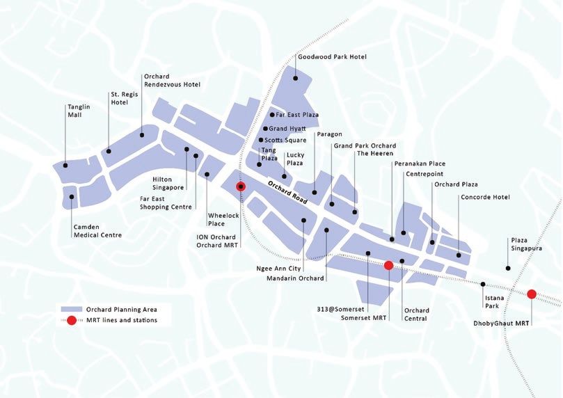
CHAPTER 15 S I N G APORE: ENHANC IN G UR BAN H E A LT H AND VIB RA N C Y BY LE V E R A GING STREET S , PAR K C O N N E CTORS, AND MAR K ET PL AC ES Ken Lee, Mina Zhan, Elyssa Kaur Ludher, Thinesh Kumar Paramasilvam, and Viknesh Gnanasagaran KEY TAKEAWAYS • Singapore has undertaken successful efforts to improve livability and vibrancy in a high-density urban setting. The city-state’s careful planning and integra- tion of open and green spaces in neighborhoods are studied through three cases: the Park Connector Network, Orchard Road, and Hawker Centers. • The Park Connector Network (PCN) has creatively transformed underuti- lized or vacant spaces along roads, overpasses, and drainage reserves into bridging public spaces that link scattered parks. It also provides ecological corridors to attract endemic biodiversity and ensure a conducive environ- ment for both park users and wildlife. • Orchard Road, a well-designed green and vibrant commercial street, is one of Singapore’s most visited free-access attractions. The successful devel- opment of Orchard Road was achieved, in part, through the government’s efforts to incentivize private sector stakeholders to enhance the overall 349
350 T H E H I D D E N W E A LT H O F C I T I E S
streetscape, including by implementing human-scale designs and empha-
sizing pedestrian-focused elements in a high-intensity, dense urban c ontext.
• Hawker centers, originally developed to accommodate unlicensed food
vendors who ply their trade on Singapore’s streets, have evolved into inclu-
sive, community-centric spaces for selling clean, affordable, and culturally
diverse foods. Although early hawker centers were stand-alone, functional
developments, the more recently built hawker centers are more sensi-
tively and carefully designed. Many incorporate universal design elements
to meet the needs of the elderly and people with d isabilities. A number of
them are co-located with a range of other community-centric amenities
and facilities.
• Key factors in the success of public-space projects are their integration
with long-term neighborhood- and city-level strategies, and the coordi-
nated interagency approach to their i mplementation. These projects have
been continuously improved over several decades to ensure that they
remain relevant and effective in meeting the needs and enhancing the
quality of life of Singapore’s population.
CITY DYNAMICS
Context and Background
Singapore has a land area of 719 square kilometers, a population of just
over 5.8 million people, and a population density of almost 7,800 persons
per square kilometer. As an island nation with no hinterland, Singapore
faces significant land c onstraints. It is also both a city and a country, and
there is a need to accommodate the needs of a nation state within a rel-
atively limited land mass: apart from the urban infrastructural needs of
housing, transport, and commerce, it also has to allocate land for uses such
as seaports and airports, military training grounds, water catchments, and
industrial parks—all of which are not typically expected or planned for in
a city.
Singapore gained self-governance from Great Britain in 1959. At the time,
much of the country’s population of about 1 .7 million resided in overcrowded,
ethnically segregated districts in the city’s Central Area. The Central Area
also had poor transport connectivity with other parts of Singapore: there was
no urban rail system, and the privately owned network of commuter buses
was badly run and unreliable. Singapore was neither livable nor sustainable:
there were slums, traffic congestion, disease, water shortages, and periodic
flooding.
The government acted quickly to resolve many of these pressing p roblems.
It established the Housing and Development Board (HDB) and built thou-
sands of affordable new homes; developed infrastructure to provide clean
water to households, industries, and other sectors; cleaned up Singapore’s
waterways and waterbodies; acquired and redeveloped districts affected by
urban blight; embarked on an ambitious landscaping program across the
island; and built new roads and highways.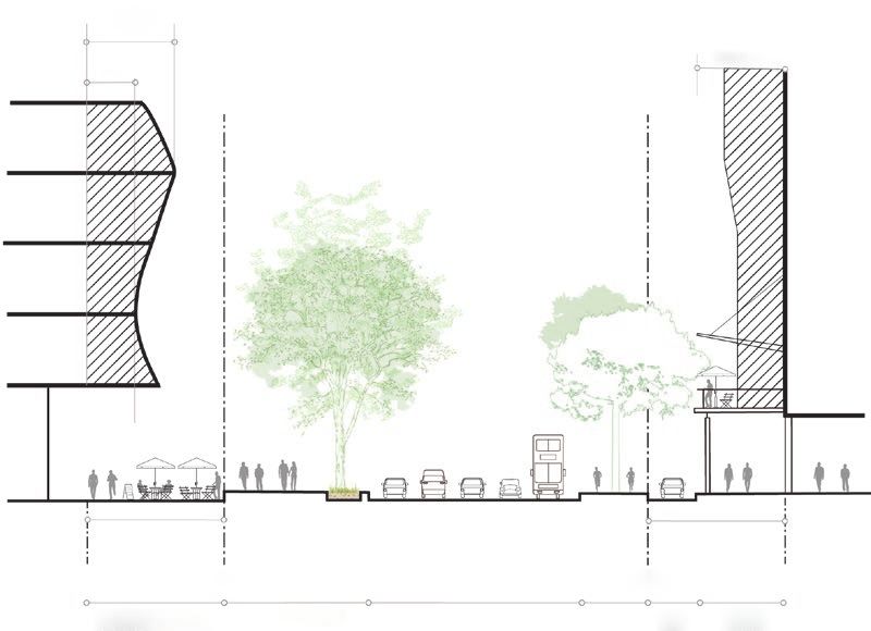
S I N G A P O R E : E N H A N C I N G U R B A N H E A LT H A N D V I B R A N C Y 351
Sixty years on, Singapore’s population has tripled, but it is one of the green-
est and most livable cities in the world despite its high population d ensity. This
is the result of decades of long-term-focused, carefully coordinated urban
planning and development. The country’s development efforts involved doz-
ens of specialized government agencies adopting a sensitive approach to man-
aging its scarce land resources. Although economic growth has been a critical
priority shaping how Singapore manages and uses its land, development has
not taken place haphazardly. As far as possible, Singapore’s planners have bal-
anced economic growth imperatives with the need to safeguard and enhance
livability outcomes. This has manifested itself in several ways, including the
establishment of well-planned and attractive public spaces.
Planning Act. Singapore’s Concept Plan and Master Plan (both further
described below) are statutory land-use plans prescribing the allowable use
of each land parcel in Singapore. These plans have legal effect under the
Planning Act, meaning that they cannot be arbitrarily amended or revised
without proper legal p rocedure. The Planning Act also prescribes how an
individual or corporate body can develop and use any given land parcel.
Appropriate approvals must be obtained from the planning authority and
other technical agencies before any development can be constructed. At the
same time, the Act provides flexibility for prescribed uses to be reviewed and
amended upon application from agencies, developers, and land owners; this
allows some degree of deviation from established planning parameters but
only if there is a demonstrable n eed. This integrated and formalized planning
and development framework guides the finalization and implementation of
plans at the national and local scales.
Concept Plan. At the national level, long-term urban policies and infrastruc-
ture investment needs are integrated through a common national Concept
Plan, which sets out broad land uses over a time horizon of 40–50 years.
Updated every 10 years, it determines the overall spatial structure of the
country, indicating broad land-use allocations in consideration of long-term
population needs and economic growth projections.
Master Plan. The Master Plan translates the Concept Plan in greater detail.
This detailed plan prescribes how Singapore’s land parcels can be devel-
oped to (a) accommodate existing and future needs in sectors such as com-
merce, industry, housing, and the community; and (b) provide open space
and greenery, public amenities, transportation networks, and other forms
of infrastructure. The Master Plan has a 15- to 20-year horizon to guide
Singapore’s development over the medium term and is reviewed every four
to five years to respond more nimbly to changes in land-use needs.
In 2019, the government embarked on a review of the Master Plan. The
review focused on several key land-use and planning themes, including
the creation of livable and inclusive c ommunities. To achieve this, the gov-
ernment will develop new residential precincts that provide a variety of
community-centric amenities and vibrant public s paces. It also plans to con-
tinue long-standing efforts to conserve the country’s natural heritage and
expand the islandwide network of parks, sports facilities, and green spaces.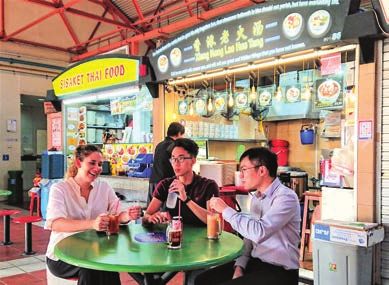
352 T H E H I D D E N W E A LT H O F C I T I E S
Another theme of the Master Plan is the rejuvenation of “familiar places”:
districts in Singapore with a strong sense of local identity and familiarity to
residents. The government is intending to implement urban planning and
design interventions to safeguard and enhance the distinctive qualities of
these districts, including through the improvement of existing public spaces
and streetscapes.
As with previous reviews, the 2019 review of the Master Plan was under-
taken in consultation with government agencies, civil society groups, pro-
fessional institutes, and private sector experts, among other stakeholders.
The plans were also exhibited to the public at the Urban Redevelopment
Authority’s (URA) headquarters in downtown Singapore, with visitors
encouraged to give their feedback and comments. This wide-ranging and
meaningful consultation process was intended to ensure that the govern-
ment’s land-use plans incorporate the views of different groups in society and
result in outcomes that will meet the needs and interests of the community
at large.
At the local level, the URA also maintains detailed plans for selected areas
which translate the relatively broader planning vision of the Master Plan in
even further d etail. These plans are typically applied to areas of significant
planning importance, such as the retail corridor of Orchard Road and new
Central Business District (CBD) of Marina B ay. Through these plans, the URA
imposes specific planning and urban design guidelines covering features
such as building height, building form, building edge, pedestrian networks,
and vehicular access requirements. These plans enable the URA to take a
finer-grained approach to determining the overall physical quality of these
districts.
Greening Singapore
Visitors to Singapore are often struck by the amount of greenery and
landscaping throughout the city. Indeed, parks, gardens, and greenery
are key features in Singapore’s urban fabric and central to its develop-
ment story.
Singapore’s early leaders had a vision to develop Singapore into a “Garden
City” and embarked on decades of sustained focus and commitment to green
the country—seeing this as a necessary move to stave off urban blight and pol-
lution even as Singapore pursued economic growth and industrialization in
the decades immediately following its founding as an independent city-state.
Singapore also perceived value in the development of lushly landscaped pub-
lic spaces as a means to spur the growth of the tourism industry as well as
enhance the country’s attractiveness to foreign investors (photo 15.1). The
Garden City Action Committee (GCAC) was thus set up in 1973 to drive this
effort by fostering pervasive greenery and establishing a network of green
spaces comprising parks, gardens, and nature reserves.
Decades of effective greening efforts have resulted in several positive out-
comes for Singapore’s population. Today, almost 10 percent of Singapore’s
land is made up of parks and nature reserves. More than 80 percent of
households are within a ten-minute walk of a p ark. An extensive network of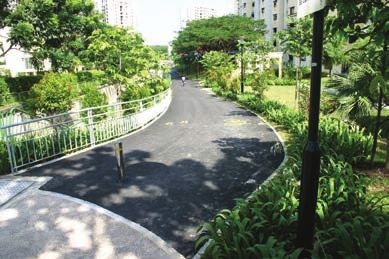
S I N G A P O R E : E N H A N C I N G U R B A N H E A LT H A N D V I B R A N C Y 353
PHOTO 15.1 Mass Rapid Transit (MRT) Train Passing through a Lush, Green Area of Singapore
Source: Jason G
oh. License-free image from Pixelbay.
landscaped park connectors extends for more than 200 kilometers, and some
1,000 hectares of bodies of water are open for recreational activity. There are
also more than 20 hydraulic engineering and water management projects
under the “Active, Beautiful and Clean Waters” program, which have trans-
formed utilitarian concrete drainage canals into attractively landscaped,
publicly accessible streams (MND and MEWR 2015).
In many parts of the country, urban design and planning interventions
such as the Landscaping for Urban Spaces and High-Rises (LUSH) program
have transformed the cityscape in a unique and striking w ay. Under the LUSH
scheme, developers are granted building incentives to integrate landscaping
at the ground level, on building rooftops, and in intermediate parts of new
developments. Many buildings feature extensive green walls and landscaped
façades, roof gardens, and outdoor planters, providing a visual counterpoint
to the high-rise, dense urban environment.
These and other efforts to promote urban green cover and landscaping
have enabled Singapore’s residents to live in a high-quality environment with
pervasive greenery. Beyond nature reserves in and around areas such as the
Central Catchment Area and Bukit Timah (a planning area and residential
estate in the westernmost part of the Central Region), there are extensive
park spaces in the heart of the CBD (such as Gardens by the Bay), smaller
green spaces in interim spaces between high-rise developments (such as
Tanjong Pagar Park), and neighborhood “pocket parks” with fitness and play-
ground equipment for recreation. In many public housing estates, residents
are even encouraged to use such spaces for community gardening and small-
scale farming.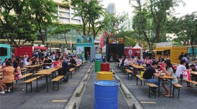
354 T H E H I D D E N W E A LT H O F C I T I E S
ORCHARD ROAD
Phase 1: Context
Orchard Road, one of Asia’s most famous shopping streets, is often com-
pared with New York’s Fifth Avenue and Paris’s Avenue des Champs-Élysées.
Stretching over 2.6 kilometers, the street extends from Tanglin Road, an
upmarket residential area in the west, to Bras Basah Road, which connects to
the CBD toward the east (photo 15.2).
Orchard Road started life in the 1830s as a central artery servicing nutmeg
and pepper plantations in the v icinity. Over the following decade, as an unknown
crop disease triggered a decline in crop yields and agricultural activity in the
area, Orchard Road took on a more residential character, with bungalows and
shophouses being built on plots formerly used for farming (Abraham 2003).
By the early 1900s, shops and businesses began opening along Orchard
Road to serve residents, heralding the start of the area’s c ommercialization.
In 1917, the Singapore Cold Storage Company opened a store to distribute
food supplies, and the Orchard Road Market provided fresh produce for
residents (Cheah 2003). In 1958, the landmark department store C. K. Tang
opened on Orchard Road. The district’s image as a retail street continued
to develop in the 1970s and 1980s, when many more shopping centers were
built. With the opening of other commercial developments such as hotels
and entertainment centers, Orchard Road established itself as a major shop-
ping, entertainment, and hotel district in Singapore.
Orchard Road was a busy thoroughfare even in the early days of horse-drawn
carriages and jinrikisha (rickshaws) and was one of the first streets in Singapore
to be macadamized in 1912 (Cheah 2 003). Motorized traffic replaced these out-
moded forms of transport in the following decades, but Orchard Road took on
PHOTO 15.2 View of Orchard Road, Singapore, from the Junction of Paterson and Scotts Roads
Source: Jason G
oh. License-free image from Pixelbay.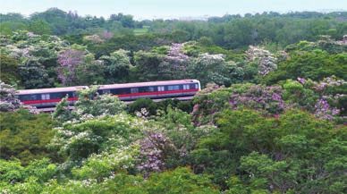
S I N G A P O R E : E N H A N C I N G U R B A N H E A LT H A N D V I B R A N C Y 355
an increasingly pedestrian-oriented character in the 1970s when Stamford Canal,
built in the 1960s to alleviate flooding in the area, was covered up to expand pub-
lic gathering and pedestrian spaces along the street (CLC 2015).
Sidewalks were first built as part of a 1976 state-implemented project to pro-
mote pedestrian walkways along Orchard Road. These and other subsequent
street improvement projects provided both sides of Orchard Road with the wide
pedestrian malls that have become one of the area’s most visible characteristics.
The pedestrian-oriented character of Orchard Road was reinforced in 1987 with
the opening of three underground Mass Rapid Transit (MRT) stations, which sig-
nificantly improved public transport access to and within the Orchard Road dis-
trict, burnishing its position as Singapore’s preeminent retail corridor.
By the end of the century, Orchard Road had developed a distinct commer-
cial identity encompassing a variety of uses along the s treet. Retail and commer-
cial developments such as Centrepoint Shopping Centre and Tang Plaza catered
to local and overseas shoppers, hotels like the Mandarin Orchard and Hilton
Singapore met the needs of tourists and visitors, and recreational complexes like
the nightlife-oriented Peranakan Place and Orchard Cinema enhanced Orchard
Road’s appeal as a premier entertainment area. Mixed-use developments inte-
grating residential uses such as Lucky Plaza and office uses such as Ngee Ann
City added diversity and urban texture to the area, as they drew a resident popu-
lation and office workers to the retail-oriented district (map 15.1).
MAP 15.1 Key Destinations along Orchard Road, Singapore
Source: ©Centre for Liveable Cities (CLC). Reproduced, with permission, from CLC; further permission required for reuse.
Note: MRT = Mass Rapid Transit.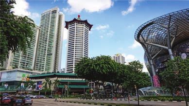
356 T H E H I D D E N W E A LT H O F C I T I E S
From the 1960s to the 1980s, Orchard Road’s appeal to overseas visitors
as a leading retail destination with a wide offering of shopping experiences
and attractive prices and merchandise rose in tandem with the growth of
Singapore’s tourism industry. However, in the early 1980s, Orchard Road’s
growth was affected by a slump in the tourism industry. In its November 1984
report, the Ministry of Trade and Industry’s (MTI) Tourism Task Force assessed
that Singapore, in its quest to build a modern metropolis, was losing its “ori-
ental mystique and charm,” of which old buildings, traditional activities, and
bustling roadside activities were key e lements. A strong Singapore dollar and
rising cost of living also meant that Singapore was no longer the inexpensive
shopping paradise it once was to foreign visitors (CLC 2015).
The tourism industry experienced greater fluctuation and uncertainty in
subsequent d ecades. Global events such as the 1997 Asian financial crisis, the
September 11 attacks in the United States, and the outbreak of severe acute
respiratory syndrome (SARS) in Asia jolted Singapore’s economy, adversely
affecting visitor arrivals and tourism revenue over a number of years (Meng,
Siriwardana, and Pham 2 013). As Singapore’s neighboring countries rapidly
developed, local retail was also affected by increasing competition from
other regional hubs like Kuala Lumpur, Bangkok, and Shanghai (NAS 2004).
Domestically, new malls and commercial centers had proliferated in
Singapore’s suburban areas since the late 1990s. These new centers were
built as part of the decentralization strategy of the 1991 Concept P lan. The
plan called for the creation of regional, subregional, fringe, and town cen-
ters across Singapore to relieve congestion in the CBD and to bring cultural,
recreational, shopping, and entertainment facilities, as well as employment
opportunities, closer to residents in newly built housing estates. As a result,
although Singapore saw an increase in the amount of retail space island-
wide, the bulk of it was located in suburban developments such as Tampines
Mall (1995) and Causeway Point (1998)—new shopping complexes popularly
known as “Heartland malls”—in the new towns of Tampines and Woodlands,
respectively. These two shopping centers alone accounted for more than
100,000 square meters of retail space in Singapore.
At the local level, the government encountered significant challenges in
implementing spatial plans to enhance Orchard Road’s appeal as a shopping
attraction. Historically, Orchard Road had not been planned or conceived as
a coherent shopping and entertainment street; rather, the area had grown rel-
atively organically to accommodate a wide range of retail profiles and spatial
typologies. Consequently, the area lacked elements such as visual harmony
in the design of retail frontages, which can be seen in many major shopping
streets in more established retail capitals in E urope. This was not an easy
problem to address because much of Orchard Road was already built up,
with limited vacant land available for major planning interventions. It was
therefore necessary to adopt incremental, creative, and collaborative efforts
with development owners to rejuvenate Orchard Road.
Phase 2: Planning and Design
Over a decade starting from the late 1990s, the government implemented
several incremental design- and planning-based interventions to improve
Orchard Road. These involved efforts such as streetscape improvements
and a reshaping of features such as building façades (figure 15.1).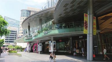
S I N G A P O R E : E N H A N C I N G U R B A N H E A LT H A N D V I B R A N C Y 357
Urban pattern Roofscape Pedestrian network Open space
Frameworks for Iconic buildings like ION Seamless system of walkways, A variety of open
land-use and Orchard provide a powerful, promenades, underground spaces provides
infrastructure give highly identifiable image pedestrian links (orange), and visual relief and
order and coherence for the street, giving through-block links provide contrast in the built
to Orchard Road. occupants of high buildings practical, safe, weather-proof environment, serving
an interesting view. and attractive walking as public areas and
experience along with markers for users.
activity-generating uses (blue).
Streetscape Vehicular access Building form
Building edges, scale Location of vehicular access Variations in height and
landscape, and street points along secondary service volume give Orchard Road
activities add to the roads minimizes pedestrian-vehicular character and visual
experience at street conflict and ensures the smooth interest while responding
level and give Orchard flow of pedestrians (orange) and to the surrounding context.
Road its unique character. traffic (brown).
FIGURE 15.1 Integrated Design Components for Orchard Road Improvements, Singapore
Source: ©Centre for Liveable Cities (CLC). Reproduced, with permission, from CLC; further permission required for reuse.
Tourism and Economic Strategies
Orchard Road has been designated a shopping street in Singapore’s land-use
master plans since 1 958. The improvement of Orchard Road has been cou-
pled with tourism and economic strategies at the city l evel. A major response
to the slump of the tourism industry in the 1980s was a S$1 billion Tourism
Product Development Plan—Singapore’s first master plan to direct its tour-
ism landscape development over the next decade (STB 2014). Another major
thrust to the development of Orchard Road came with the “Tourism 21—
Vision of a Tourism Capital” plan in 1997, which sought to capitalize on the
rising tourism potential within the Asia-Pacific market in the 1990s by focus-
ing on experiential “software” such as the provision of quality services and
programs (CLC 2015; box 1 5.1). These plans, complemented by other devel-
opment plans, helped to steer and support the implementation of the broad
vision and strategies set out in the tourism plans.
In the late 1990s, zoning revisions resulted in the creation of 55 “local plan-
ning areas” across Singapore. Fifty-five Development Guide Plans (DGPs)—one
for each local planning area—were consolidated to form Master Plan 1998. The
DGP for the Orchard Road Planning Area designated it as a primary commer-
cial and residential belt within Singapore’s Central Area (a planning term used
to denote Singapore’s city center) that included areas such as the Downtown
Core. The plan acknowledged Orchard Road’s success as the result of a good358 T H E H I D D E N W E A LT H O F C I T I E S
BOX 15.1 TOURISM 21—VISION OF A TOURISM CAPITAL
A major thrust to the development of Orchard Road came via the 1997
“Tourism 21—Vision of a Tourism Capital” framework, produced by four
committees set up in 1995 to facilitate the development of a comprehen-
sive plan to boost Singapore’s tourism industry.
Unlike the earlier tourism plan that emphasized “hardware” improvements,
Tourism 21 emphasized “software”—specifically, the provision of quality ser-
vices and programs for tourists (CLC 2015). Along with 11 other popular
tourist areas such as Chinatown, Singapore River, and Little India, Orchard
Road was identified as a district where existing offerings could be enhanced
and repackaged into a variety of tourism products. The plan also proposed
ideas to reposition and develop a retail belt extending from Orchard Road
to Marina Bay (in the heart of the Downtown Core) as a “Mall of S ingapore.”
The Tourism 21 plan further recommended “tapping the commercial expe-
rience of the private sector” and forming “mutually beneficial partnerships”
by creating and supporting stakeholder and trade associations to help over-
see future retail development in S ingapore. This resulted in the formation
of the Orchard Road Committee, a representative body comprising major
shopping centers along Orchard Road. This committee evolved into the
Orchard Road Business Association (ORBA), a place management organi-
zation that works with the Singapore Tourism Board (STB) on collaborative
efforts to promote Orchard R oad. More than 120 members comprising
building owners, retailers, and other stakeholders voluntarily contribute
membership fees to ORBA to support events and marketing activities
designed to enhance the district’s visitor experience and attractiveness.
To foster a pro-business culture and create a conducive operating envi-
ronment for the tourism industry, the Tourism 21 plan proposed financial
incentives in the form of a Tourism Development Assistance Scheme to
help local tourism-related companies upgrade their products and s ervices.
In the late 1990s and early 2000s, Singapore’s tourism industry faced increased
competition from other regional cities. Global shocks such as the severe acute
respiratory syndrome (SARS) outbreak further dampened sentiments in the
tourism industry. In a bid to revitalize the sector, the Ministry of Trade and
Industry (MTI, which oversees the STB) launched the Tourism 2015 plan in
(box continues next page)
mix of office, shops, and hotel uses but highlighted the need for new develop-
ments to reinforce existing commercial uses along the street and address the
lack of residential population along Orchard Road. The DGP also identified
various issues facing pedestrians in the area, setting the ground for a slew of
subsequent interventions.
Following the DGP, the URA also introduced a Landmark and Gateway
Plan, under which strategically located vacant land parcels, such as those
above the underground Orchard MRT station and Somerset MRT station,S I N G A P O R E : E N H A N C I N G U R B A N H E A LT H A N D V I B R A N C Y 359
BOX 1 5.1 OURISM 21—VISION OF A TOURISM CAPITAL
T
(Continued)
January 2005 to promote tourism growth over the next 10 years. The MTI
established a fund amounting to S$2 billion to support initiatives in a number
of areas, including infrastructure development, capability development for
tourism and retail sector workers, the organization of signature events, and
development of unique tourist-oriented products.
As for the development of Orchard Road, various government agencies
complemented the broad tourism promotion strategy by announcing a
series of initiatives to spruce up the street, including a planned S$40 mil-
lion investment to expand Orchard Road’s public infrastructure. These ini-
tiatives included efforts to improve pedestrian walkways and create “urban
green rooms” for e vents. As part of this proposal, three distinct themed
zones were created at Orchard Road, each with enhanced road and pedes-
trian mall lighting that highlighted the district’s mature trees and foliage to
create attractive night streetscapes. This initiative was driven by an STB-
led taskforce comprising agencies such as the URA, the Land Transport
Authority (LTA), and the National Parks Board (NParks).
The government’s plans to enhance Orchard Road’s appeal, including its
attractiveness to tourists and Singaporeans, continue to take shape. In recent
years, agencies have focused on making Orchard Road a “lifestyle destina-
tion,” with innovative retail concepts, attractions, entertainment, and e
vents.
In 2019, an interagency review of the district’s development resulted in a
comprehensive approach to split the area into the four subzones of Tanglin,
Orchard, Somerset, and Dhoby Ghaut, each with customized strategies to
enhance their respective identities. These include positioning Tanglin as an
arts- and culture-focused area, Somerset as a center of youth culture, and
Dhoby Ghaut as a family-friendly destination.
The 2019 Master Plan further showcased many of these plans, including
efforts to improve connectivity across buildings and activate vacant land
parcels across the district as locations for pop-up events such as con-
certs and markets. The Master Plan also highlighted efforts to “Bring Back
the Orchard,” which would entail the provision of new infrastructure to
enhance green spaces throughout the precinct.
Sources: STB 2005, 2014; STPB 1997; URA 2001, 2
007.
were identified as potential focal points that could be developed in a way that
would make the city center more distinctive and memorable (URA 2001). By
redeveloping these vacant parcels, new mixed-use developments incorporat-
ing innovative retail concepts and public space began to take shape along
Orchard Road. In the case of the vacant site above the Orchard MRT station,
planning authorities relaxed existing urban planning rules (for example, on
building height), allowing for the development of a 218-meter-high retail and
residential development, ION Orchard.360 T H E H I D D E N W E A LT H O F C I T I E S
Urban Design Strategies
The URA has introduced a series of urban design guidelines since the early
2000s to guide the physical development of buildings fronting Orchard Road.
Over the years, these guidelines have been reviewed, updated, and expanded,
taking into account feedback from architects and stakeholders, to remain rel-
evant and pro-business. The guidelines help to shape the visitor experience
along the street by providing guidance to developers and property owners
on matters such as allowable uses, building forms, p
edestrian networks, and
vehicular access arrangements.
Shaping Building Setbacks and Edges. Urban Design Plans and Guidelines
for Orchard Road were first published in 2002 following a joint STB and URA
exhibition to gather public and stakeholder feedback on proposals to enhance
Orchard Road (URA 2013b). Key focus areas of the guidelines were façade
articulation and urban verandas. The guidelines pushed for changes in building
façades to create better physical and visual connections between the street
and building activities (figure 15.2) and recommended the use of transparent
materials to make shopfront displays more visible and attractive (URA 2005c).
Urban verandas, intended as publicly accessible, unenclosed extensions of
buildings, were also encouraged.
Up to 7.5 m
(subject to design
evaluation)
Up to 7.5 m
4m
Covered Covered
Walkway Walkway
7.6 m/11.6 m 7.6 m/11.6 m
Buffer Buffer
Building Line Road Reserve Line Road Reserve Line Building Line
(indicative) (indicative)
Outdoor Refreshment Mall Orchard Road Side Service Urban
Area (ORA) Zone Table Road Veranda
FIGURE 15.2 Possible Urban Veranda and Façade Articulation Incentives in Orchard Road, Singapore
Source: ©World Bank, based on Urban Redevelopment Authority (URA). Further permission required for reuse.S I N G A P O R E : E N H A N C I N G U R B A N H E A LT H A N D V I B R A N C Y 361
The URA extended an incentive to building owners by allowing them
to build floor area above the permissible development intensity for such
extensions. This prompted many of them to overhaul their
properties.
For example, Wisma Atria, a commercial development on Orchard Road,
announced a S$31 million makeover in the early 2010s to create greater front-
age visibility for retailers as well as improved accessibility (Sng 2015).
The guidelines and associated incentives worked well: in the 2000s,
“nearly every building fronting the street underwent a façade transformation
in return for additional income-producing space,” transforming old, familiar
retail spaces into new destinations (Anderson et al. 2012). These guidelines
shaped and articulated building setbacks along Orchard Road in a way that
safeguarded the contiguity of the pedestrian mall and maintained a sense
of openness to the s treet. While ensuring some degree of uniformity at the
street block level, the URA’s framework of urban design guidelines was flexi-
ble enough to accommodate a variety of façade configurations, enabling the
creation of diverse visual and spatial experiences along the street.
Reducing Pedestrian-Vehicular Conflict. In the early days, multiple vehicular
entrances and driveways to individual buildings along Orchard Road affected
the pedestrian experience because there was no continuous promenade.
Planning guidelines introduced in the 1980s required new developments to
locate vehicular entrances at the rear of b uildings. But gaps still remained
because these requirements were not imposed on existing developments
(Cheah 2003). To address this issue, the DGP 1994 recommended the creation
of comprehensive rear service lanes for new developments along the street
(URA 2001). This approach was expanded in 2000, when the URA implemented
a plan to remove front-facing vehicular access points to several buildings and
establish a rear service-road system (CLC and SI 2016).
Gradually, the number of pedestrian-vehicular intersections along Orchard
Road was reduced as new development and redevelopment proposals com-
plied with the new guidelines. For example, when the owners of the Mandarin
Orchard submitted a redevelopment proposal to the URA in 2009, planners
required the hotel to relocate its vehicular drop-off points fronting Orchard
Road to the site’s western boundary along Orchard Link. Additionally, the
hotel lobby was relocated to the upper floors to accommodate more retail uses
at the ground level, which would open to Orchard Road (Anderson et a l. 2012).
The effect of this was to enhance the porosity of the development and add
texture to the promenade through the provision of different shopfronts and
window displays. As they were applied from one plot to the next, the build-
ing frontage guidelines enhanced the Orchard Road promenade and further
improved pedestrians’ experience of the area (photo 15.3).
Creating a Comprehensive Pedestrian Network and Active Streetscape.
The URA used specific urban design guidelines to provide seamless
pedestrian connectivity between MRT stations and key d evelopments.
Working closely with building owners and developers, the URA spearheaded
plans for the development of a comprehensive pedestrian network at the
basement level as well as at the ground or second levels in Orchard Road
and other parts of the Central A
rea. To promote all-weather connectivity, a
Central Area Underground Master Plan was drawn up to map existing and362 T H E H I D D E N W E A LT H O F C I T I E S
PHOTO 15.3 overed Walkways and Urban Verandas at the Ground and Second Floors of Mandarin
C
Gallery in Orchard Road, Singapore
Source: ©Ken L ee. Used with the permission of Ken Lee; further permission required for reuse.
proposed underground pedestrian links, and private sector stakeholders
were incentivized to contribute toward their implementation. In some cases,
the URA imposed requirements on developers to incorporate features such
as knock-out panels in the walls of MRT stations to provide seamless links
between stations and future developments, or through-block links at ground
level to create internally permeable street blocks.
To ensure that the pedestrian realm remained vibrant throughout the day,
the URA encouraged developers to locate activity-generating uses such as
retail, food and beverage outlets, and recreational uses along key pedestrian
thoroughfares. The URA exempted these pedestrian thoroughfares from GFA
computation, and developers were required to abide by various planning
conditions, such as ensuring that these thoroughfares be kept free of obstruc-
tions (for example, structural installations) that could hinder pedestrian flow
and remain open to the public at all times.
Given that most buildings along Orchard Road were built before man-
datory accessibility requirements were introduced in 1990, the Building
and Construction Authority (BCA) worked closely with building owners to
improve barrier-free access to their premises. This was done through the
provision of monetary grants to defray upgrading and construction costs.
As a result, about 90 percent of buildings along the Orchard Road shopping
belt are currently universally accessible, up from only 41 percent in 2006
(Keung 2018).
These and other interventions helped create pedestrian connections that
integrate the diverse uses on Orchard Road in a coherent w ay. For example, a
new through-block connection at 313@Somerset, a commercial development,S I N G A P O R E : E N H A N C I N G U R B A N H E A LT H A N D V I B R A N C Y 363
serves as a busy pedestrian thoroughfare that not only provides direct access
from Orchard Road to the Somerset MRT station but also features v arious
uses that imbue it with a lively, street-like character.
Promoting Roadside and Vertical Greenery. Lush greenery at multiple levels,
within both the public realm and private developments, has contributed
significantly to the spatial quality of Orchard Road and serves as an important
visual signpost of the area’s historical incarnation as plantation land. Public
spaces along the pedestrian malls were defined by an avenue of pterocarpus
indicus (commonly known as “angsana” trees), first planted in the 1970s as part
of the Garden City Movement that aimed to transform Singapore into a clean
and green city (CLC and SI 2016).
In subsequent years, the URA and NParks used numerous guidelines and
policies to encourage developers and building owners to provide landscaped
areas in their developments. Many of these have been incorporated into the
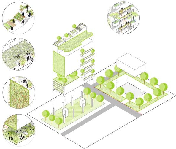
LUSH framework (figure 15.3). Under the LUSH program, the Landscape
Rooftop
urban
farming
Communal planter
boxes
2.0 m peripheral
planting verge
Roof
garden
Green
walls
Story landscape Physical buffer
Sky
area or covered
terrace 3.0 m or 5.0 m
communal ground
garden green buffer
FIGURE 15.3 Possible Types of Landscape Replacement Areas under the LUSH program, Singapore
Source: ©World B
ank, based on Urban Redevelopment Authority (URA). Further permission required for reuse.
Note: LUSH = Landscaping for Urban Spaces and High Rises; m = meters.364 T H E H I D D E N W E A LT H O F C I T I E S
Replacement Area Guidelines for selected strategic development areas in
Singapore require developers to replace greenery in the form of landscape
areas within the new development project. The total area of landscaped
space, which could be provided at ground level, rooftops, or mid-level sky
terraces, has to be minimally equivalent to the development site area. In
addition, there are also other guidelines on GFA exemptions for communal
sky terraces, and GFA incentives for rooftop outdoor refreshment areas to
encourage developers to convert their existing roofs into roof gardens or
green roofs (URA 2014).
The LUSH program today is complemented by the NParks’s Skyrise
Greenery Incentive Scheme (SGIS), whereby developers can tap public
funds to pay for 50 percent of the cost of installing rooftop and vertical
greenery. These initiatives have been adopted by the developers and own-
ers of many developments in Orchard Road, including 313@Somerset and
Orchard Central, which feature extensive vertical and rooftop green spaces
(NParks 2017).
Looking beyond the Site
As part of the government’s 2019 plans for the future development of Orchard
Road, agencies highlighted an intention to improve the connectivity of the
district’s main promenade with surrounding a reas. For example, there are
plans to enhance the diversity of visitors’ experience of the precinct by
encouraging them to explore historic side streets such as Emerald Hill and
Killiney Road, which connect the main shopping district to surrounding
residential enclaves. There are also plans to implement urban design inter-
ventions to provide seamless connectivity between Orchard Road and other
parts of Singapore through having more mixed-use transit-oriented devel-
opments (TODs) sited above the future Orchard MRT interchange station,
incorporating the Thomson-East Coast Line (URA 2019a).
Phase 3: Implementation
Agencies are aware that the success of urban planning and design strategies
requires the active participation of developers and landowners, particularly
in the densely textured, mixed-use context of the Orchard Road precinct.
In order to achieve this, agencies have used a combination of incentives
and regulations to both encourage and require private sector stakeholders
to adopt spatial changes to meet various planning, economic, and social
objectives for Orchard Road.
Government Land Sales to Spur Rejuvenation: Clear Guidelines to
Ensure Win-Win Outcomes
One of the important ways in which the government has worked closely
with the private sector to enhance the Orchard Road precinct is through
the sale of state-owned land parcels for new commercial and mixed-use
developments. The Government Land Sales (GLS) program, established
in 1967, enabled the construction of several landmark developments alongS I N G A P O R E : E N H A N C I N G U R B A N H E A LT H A N D V I B R A N C Y 365 Orchard Road in the 1970s and 1980s, including the Centrepoint, Le Méridien Singapore, and Orchard Plaza.1 In latter decades, the GLS program proved to be a successful tool in catalyzing the rejuvenation of Orchard Road, espe- cially when the precinct appeared to be ceding its position as Singapore’s preeminent retail attraction to newer developments in other areas. In the mid-2000s, for example, the URA decided to release three new parcels of state land for commercial development to bring new energy and excitement to the area (CLC 2017). These parcels had been kept in reserve for almost 20 years after the MRT stations along Orchard Road opened in 1987, to manage the supply of new commercial space in the area and prevent a glut. By this time, the government assessed that the release of these prime parcels would be a timely move to kick-start a new phase in Orchard Road’s development and bolster its prospects as an import- ant retail corridor in the heart of Singapore. Indeed, these parcels have been developed into some of the most popular retail destinations along Orchard Road today. The URA, as sales agent for the state, sold these land parcels to the private sector for development, with specific guidelines and conditions to ensure that the future developments would respond well to their immediate context and contribute to the success of Orchard Road as a d estination. The sales conditions included requirements on the provision of public spaces and pedestrian connections, activity-generating uses, the location of vehicular and emergency access points, and various streetscape improvements. This land sales and development approach allowed the public sector to play a sig- nificant role in influencing the forms and functions of new private develop- ments on Orchard Road. For example, one of the three GLS sites was at the junction of Orchard Road and Paterson Road, occupying a central location ideal for a develop- ment that could serve as a visual gateway to the d istrict. In offering the site for sale, the URA sought to realize the potential for the future project to be a landmark development for the district. It decided to relax the prevailing height controls for the site, enabling the construction of ION Orchard, a 218-meter-high complex comprising a retail podium with direct connection to the Orchard MRT station at the basement level and a 56-story residen- tial tower overhead. Today, ION Orchard, on the southeastern corner of the Orchard-Paterson junction, is a striking contemporary visual counterpoint to the 33-story Tang Plaza hotel tower directly across Orchard Road, which was built in 1982 with a traditional Chinese hard hill roof. The URA also required the development to incorporate cultural and civic uses: ION Orchard houses spaces for events and public activities and an observation deck offering a panoramic view of the surrounding cityscape. In addition, the URA imposed requirements to improve pedestrian connectivity between ION Orchard and other parts of Orchard R oad. For example, the developer was required to build a public concourse contiguous with the pre- existing MRT concourse at the basement level. Planning conditions such as this helped create new underground connections between ION Orchard and surrounding buildings like Wisma Atria and Wheelock Place. A public space was also created along the pedestrian mall at the ground level, adding a new civic space to Orchard Road (URA 2005b).
366 T H E H I D D E N W E A LT H O F C I T I E S
Design Quality
To ensure exceptional urban and architectural design quality, selected strate-
gic projects and key development precincts in Singapore have to go through
a Design Advisory Panel (DAP) chaired by the URA. The DAP usually com-
prises members from the architectural industry along with representatives
from other related fields. Under this DAP model, the overall design and
layout of all key development proposals at Orchard Road are guided by the
panel as part of the formal development control process.
The DAP evaluates each proposal in two s tages. In the first stage, the panel
considers broad urban design elements, including features related to build-
ing form, massing, pedestrian connectivity, vehicular circulation, view corri-
dors, and landscaping. Projects that satisfy the DAP’s criteria are then granted
provisional permission by the URA, meaning that developers can commence
some initial construction work on the development. In the second stage, the
DAP reviews more specific elements such as architectural design features,
building layout, building materials and finishes, and external lighting plans.
Proposals that meet the DAP’s review standards at this stage are then granted
final planning permission by the URA (URA 2005c).
Incentivizing the Private Sector
The government also introduced incentives to promote place management
efforts at Orchard R oad. For example, the URA introduced an “Art Incentive
Scheme for New Developments in Central Area” from 2005 to 2012, through
which developers could obtain additional buildable floor area above the stip-
ulated development intensity for their sites by providing public art installa-
tions in their developments. To qualify for the scheme, the art works must be
evaluated and endorsed by a Public Art Appraisal Committee convened by
the URA and the National Heritage Board (the public agency that manages
Singapore’s art and history museums), and developers must ensure that the
works are accessible for free public viewing (URA 2005a).
The STB also initiated schemes to offset the costs that private sector stakehold-
ers may incur in contributing to the rejuvenation of Orchard Road. For example,
the STB supported companies in obtaining tax allowances for establishing flagship
concept stores along the shopping street. Developers purchasing selected GLS
sites at Orchard Road could also enjoy a remission on the amount paid in Goods
and Services Taxes (GST, which is levied on the purchase of commercial real
estate, including vacant land parcels), subject to various conditions. Such schemes
have created win-win propositions between the private and public sectors, con-
tributing significantly to the rejuvenation of Orchard Road in recent years.
Phase 4: Management
Providing Planning Flexibility to Encourage Redevelopment
To encourage rejuvenation through innovative and high-quality development
projects that would enhance Orchard Road as the premier shopping street, the
Orchard Road Development Commission (ORDEC) was in place from 2005 to
2015 to evaluate whether major additions and alterations (A&As) or redevelop-
ment proposals, which deviate from the prevailing planning parameters, could be
regarded as special innovative projects of high quality that merit the deviations.S I N G A P O R E : E N H A N C I N G U R B A N H E A LT H A N D V I B R A N C Y 367 The commission, chaired by the CEO of URA with members from other relevant government agencies, was empowered to propose incentives and allow variations in planning requirements to support innovative develop- ment ideas. It encouraged the development of projects with unique design concepts, those that enhanced the public realm with benefits to the com- munity, and those that featured innovative business concepts and provided economic development benefits. Based on ORDEC’s recommendations of the value brought about by redevelopment, URA supported these redevelop- ment proposals by granting them various development incentives; for exam- ple, projects were allowed to deviate from existing planning parameters such as plot ratios, permissible uses, and building height restrictions (URA 2013a). More recently, URA introduced the Strategic Development Incentive (SDI) scheme in March 2019 as an expansion of the ORDEC scheme. The SDI scheme applies to strategic developments islandwide and aims to encour- age the redevelopment of older buildings in strategic areas into new bold and innovative developments that will positively transform the surrounding urban environment. Addressing Challenges Orchard Road currently faces new c hallenges. The emergence of e-commerce and evolving consumer preferences are rapidly reshaping the brick-and- mortar-centric retail landscape (Koh 2018). As the Singapore government con- tinues to pursue a policy of discouraging private motor vehicle use, there has been extensive discussion on how to further improve the pedestrian experi- ence and rethink Orchard Road’s position as a public space (MTI 2017). Efforts have been made to address these concerns. In September 2017, a committee led by the ministers in charge of urban development, transporta- tion, and industry was formed to drive efforts for the rejuvenation of Orchard Road (MTI 2017). In the near term, there are plans to refresh Orchard Road’s streetscapes by activating other vacant parcels of state land in the area. New pedestrian crossings in the form of 30-second scramble walks were tested at selected junctions during late 2017 and early 2018 to improve pedestrian connectivity across Orchard Road (Koh 2018). New retail offerings were also planned to enhance the street’s attractiveness as an integrated lifestyle and leisure precinct (STB 2017). These include Design Orchard—a retail-cum- incubation space for Singaporean brands and designers to test and promote their products—which opened in January 2019. Safeguarding and enhancing Orchard Road’s appeal in the face of new challenges is a continuous process, and one that will require close collabo- ration between agencies, development owners, businesses, and other stake- holders in the precinct. Place Management Beyond the physical characteristics of a place, there has been increasing rec- ognition of the need to enhance human vitality, buzz, and identity through a collaborative multistakeholder management p rocess. This process requires the commitment of area stakeholders to improve the management of a pre- cinct, on the basis of a shared understanding that an improved precinct can reap tangible benefits for businesses and property owners.
368 T H E H I D D E N W E A LT H O F C I T I E S
PHOTO 15.4 Pop-Up Event at Orchard Road, Singapore
Source: ©Ken L ee. Used with the permission of Ken Lee; further permission required for reuse.
At Orchard Road, the STB has been working with ORBA to drive place man-
agement initiatives to enhance Orchard Road’s image as a premier shopping
and lifestyle d
estination. With ORBA acting as the overall place manager, local
business owners and other stakeholders have been encouraged to contribute
actively through business development, promotion, and marketing activities.
Place management efforts were earlier initiated as part of the STB’s tour-
ism promotion drive. But many of these early projects have come to positively
affect not only the lives of visitors but also of Singaporeans (Hee 2017). One
such initiative is the annual Orchard Road Christmas Light-Up, launched in
1984, which has become a popular event with both tourists and locals.
More recently, pop-up events planned by the STB, ORBA, and other stake-
holders have injected vibrancy to Orchard Road (photo 15.4). These include
promotional festivals held during the “Great Singapore Sale” each year—
when retailers work together on a schedule of events held in public areas and
within shopping centers to showcase their products—as well as Fashion Steps
Out, when a long stretch of Orchard Road is closed to traffic and converted
into an outdoor fashion catwalk.
These events generate excitement and anticipation among shoppers, cre-
ating more opportunities to draw visitors and enhance business activity on
Orchard Road (Cheah 2003). Similar to place management efforts in other
parts of Singapore, public agencies and businesses work together on these
initiatives, pooling their expertise and resources.
Phase 5: Impact Evaluation
Orchard Road emerged as Singapore’s key retail corridor in the 1970s and
1980s, displacing former commercial hubs centered on areas in the Downtown
Core such as Raffles Place and High S
treet. Over the years, the precinct hasS I N G A P O R E : E N H A N C I N G U R B A N H E A LT H A N D V I B R A N C Y 369
come to play a central role in the development of Singapore’s tourism indus-
try and in the country’s positioning of itself as a cosmopolitan, open, and
friendly destination for regional and international visitors. At the same time,
Orchard Road is a familiar, well-loved gathering and recreational spot for
generations of Singaporeans from different backgrounds.
In recent years, Orchard Road has faced intense competition from
e-commerce and newer commercial precincts in suburban locations
and other parts of the Central A rea. Indeed, tourism figures suggest that
it is ceding ground to other retail a ttractions. In 2003, nearly 4 .6 million
visitors— representing 76 percent of all tourist arrivals—visited Orchard
Road; by 2016, its share of visitors had fallen to roughly 50 percent (STB
2016). Tourism aside, Orchard Road remains an appealing location for
Singaporeans: beyond shopping, a plethora of events draws thousands each
month, and well-planned, attractively designed public spaces encourage
many to visit, mingle, and socialize.
Retail rental figures suggest that Orchard Road has managed to retain its
position as Singapore’s preeminent retail d raw. Despite the highly compet-
itive retail environment, businesses appear willing to pay an increasingly
higher premium to locate themselves in Orchard R oad. In the first quarter of
2019, the median rental rate for retail space in the Orchard Planning Area was
about S$107 per square meter, or 84 percent higher than the median rental
rate for retail space in other parts of the Central Area. In the first quarter of
2014, five years prior, Orchard Road rentals outstripped those in other parts
of the Central Area by a more modest 63 percent (URA 2 019b). Beyond the
retail sector, the value of residential property in and around Orchard Road
remains robust. For example, in April 2018, the URA sold a residential site
on nearby Cuscaden Road for almost S$2,400 per square foot, setting a new
record for the price of GLS land.
The government’s planning and design measures at Orchard Road have
yielded many positive outcomes for businesses and landowners. More impor-
tantly, these interventions have created tangible improvements to the public
realm, most notably to the central promenade, and through the provision
of extensive spaces for leisure and enjoyment, ensuring that Orchard Road
remains appealing to visitors and Singaporeans alike.
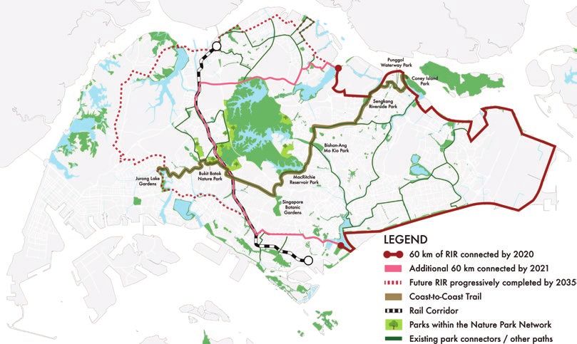
PARK CONNECTOR NETWORK
Phase 1: Context
When the Park Connector Network (PCN) was being conceptualized, the
intention was to achieve a matrix of green connectors weaving through urban
spaces and linking up Singapore’s parks, gardens, and nature reserves, thereby
increasing residents’ accessibility to nature and greenery. This involved
the curation of regional walking and cycling loops connecting major green
spaces as well as interregional c onnections. Each cycling loop would adopt
the character of the region and the parks that it connects, thereby offering
users a varied recreational experience across Singapore.
The PCN would also serve as a network of green ecological pathways. Fast-
growing, native trees and shrubs were intentionally planted to attract endemic
biodiversity such as native birds and butterflies along the PCN. This wouldYou can also read