The Wildcat - Doe Run Canadian Exploration Alliance
←
→
Page content transcription
If your browser does not render page correctly, please read the page content below
The Wildcat - Doe Run
  Canadian Exploration Alliance

             Island Lake Property
            Bathurst Mining Camp,
                New Brunswick
                        November, 2014

Wildcat is a mineral exploration company in the business of acquiring,
exploring and developing Canadian gold and base metal mineral
properties. Its head office is located in Winnipeg, Manitoba.
                                       TSX Venture Exchange: WEL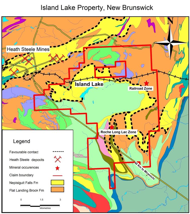
FORWARD‐LOOKING INFORMATION

This presentation may contain "forward‐looking information", within the meaning of applicable Canadian
securities legislation. Forward‐looking information includes, but is not limited to, statements with respect
to Wildcat's exploration program and plans. Generally, forward‐looking information can be identified by
the use of forward‐looking terminology such as "believes", "plans", "seeks", "expects", "budget" or
variations of such words or statements that certain actions, events or results may, could, will, will be,
would be or are expected to be. Forward‐looking information is subject to known and unknown risks,
uncertainties and other factors that may cause the actual results, level of activity, performance or
achievements of Wildcat to be materially different from those expressed or implied by such forward‐
looking information, including risks associated with the mineral exploration and mining industry such as
economic factors, government regulation and approvals, environmental risks, success of exploration
activities, future commodity prices, capital expenditures, requirements for additional capital, changes in
project parameters as plans continue to be refined, conclusions of economic evaluations, the Company's
history of operating losses and uncertainty of future profitability. Important factors that pertain to the
risks and uncertainties associated with the Company's business are discussed more fully in the Company's
disclosure documents filed from time to time with the Canadian securities regulators and available on
www.sedar.com. Although Wildcat has attempted to identify important factors that could cause actual
results to differ materially from those contained in forward‐looking information, there may be other
factors that cause results not to be as anticipated, estimated or intended. There can be no assurance that
such statements will prove to be accurate, as actual results and future events could differ materially from
those anticipated in such information. Accordingly, readers should not place undue reliance on forward‐
looking information. Wildcat does not undertake to update any forward‐looking information, except in
accordance with applicable securities laws.

                                             TSX V:WEL

                                                2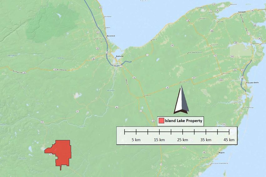
Introduction
Alliance of Doe Run Canadian Exploration ULC
and Wildcat Exploration Ltd, formed in 2012
Island Lake property optioned in 2012
Exploration began on Island Lake in 2013
• Exploration activities have included
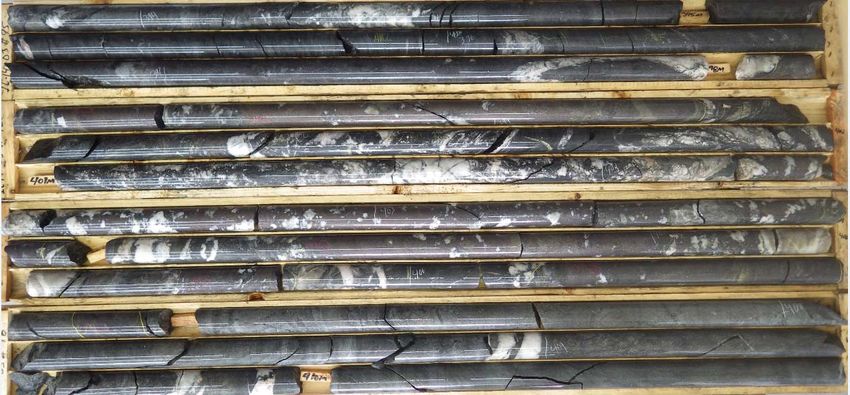
− 2 Seasons of drilling ‐ total of 19 DDH and 8,011 m
− Soil geochemistry and lithogeochemistry
− Ground and down‐hole geophysics
− Field mapping and data mining
3
Island Lake Property Location

                                   Bathurst

                  Brunswick #12

                             Brunswick #6

Heath Steele
                    Island Lake

                                     4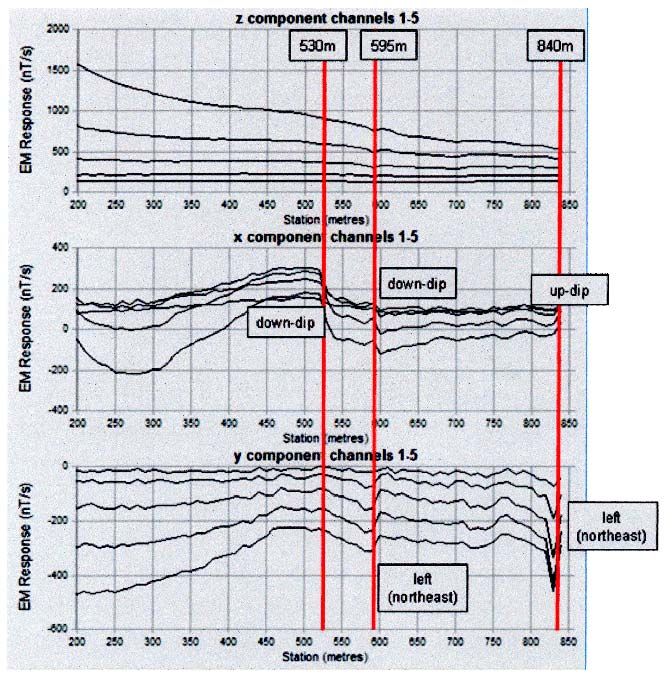
Island Lake Property Location

             5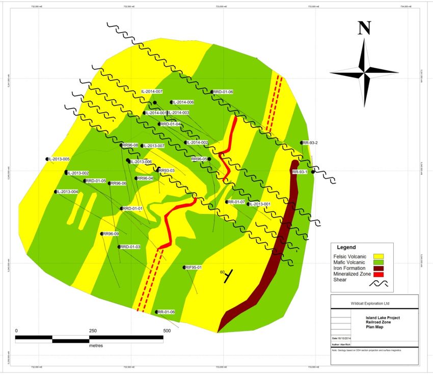
Property Overview
  Heath
  Steele
  Mines                           Railroad
                                   Target
                                    Area

                                    Roche
Rusty Ridge                       Target Area
Target Area

                   6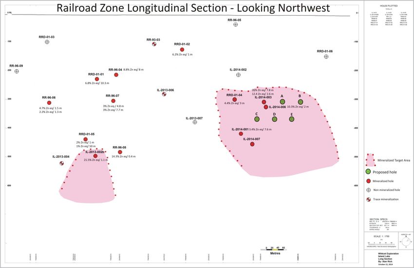
Drilling Overview
2013 Summer Drilling
• Completed 7 DDH on two target areas
• Total of 3,569 meters drilled
• 228 samples dispatched for assay and lithogeochemistry
2014 Summer Drilling
• Completed 12 DDH and one re‐drill on two target areas
• Total of 4,442 meters drilled including the re‐drill of a
2013 hole
• 697 samples dispatched for assay and lithogeochemistry
7
Railroad Zone Plan Map

          8
Drill Results
Significant intersections in Railroad target area:
Hole True From Zinc Lead Copper Silver
Width Depth % % % g/tonne
RRD‐01‐04 3.0 m* 420 m 2.15 0.84 0.27 26.8
IL‐2013‐002b 2.0 m 594 m 6.52 3.22 0.54 68.1
IL‐2014‐001 6.2 m 500 m 2.38 0.55 0.11 19.11
IL‐2014‐003 2.6 m 389 m 6.57 2.78 0.46 68.1
& 7.8 m 398 m 14.51 5.85 0.67 139.9
IL‐2013‐006 1.7 m 409 m 5.57 2.71 0.17 56.6
*Historic data core length for RRD-01-04
9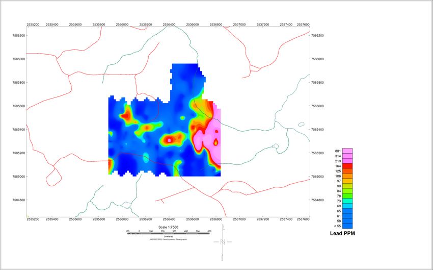
Railroad Cross Section, Looking Northeast

                                         14.51% Zn, 5.85% Pb,
                                        0.67% Cu, & 139.9g/t Ag
                                        across 7.8 m true width

               mafic volcanics

                                                felsic volcanics

      Zn-Pb-Cu-Ag mineralization

                                   10
Railroad Longitudinal Section
11IL‐2014‐003 Massive Sulfide Intercept
14.5% Zn, 5.85% Pb,
0.67% Cu, 139.9 g/t Ag
across 7.8 m true width
12Down‐Hole Geophysics
• Down‐Hole pulse EM surveys were IL-2013-002b
run in IL‐2013‐002b and IL‐2014‐006
• Both surveys have indicated continued
mineralization of notable size down dip
from intercepts encountered in both
holes
IL-2014-006
13Drill Map – Roche Lac Long
2.36% Zn, 1.03% Pb,
.04% Cu, 6.51% Ag
across 8.5 m true width
14Drill Map – Roche Lac Long (EM)
15Roche Long Lac Drill Results
Significant intersections in Roche target area:
• IL‐2014‐009
1.98% Zn, 0.83% Pb, and 0.03% Cu and 4.50 g/tonne Ag
over 14.1 m true width from 168 m depth
includes 2.36% Zn, 1.03% Pb, 0.04% Cu and 6.51 g/tonne
Ag over 8.5 m true width from 168 m depth
• IL‐2014‐010
No significant assays, however, intersected the contact
with the Flat Landing Brook (“FLB”) and Nepisiguit Falls
(“NF”) formations.
The stratabound mineralization at the FLB/NF contact
constitutes a similar geological setting to the
environment hosting the Heath Steele deposits
16Project Future
Drill programs on Railroad and Roche Long Lac
Zones are being planned for 2015
• DDH program with geophysics run in support will be
the core of the program
• Possible expanded prospecting program
Detailed 3D models accounting for structures
and lithology to refine drill targets and spotting
17Acknowledgements
Thanks to prospector, Frank Ross, for on‐going
assistance
Thanks to the N.B. Department of Energy and
Mines for technical support and on‐going sharing
of expertise and knowledge of the Bathurst
Mining Camp and the use of the Madran core
facility
18Wildcat Exploration Ltd.
John Knowles, CEO j.knowles@wildcat.ca
Tom Lewis, V.P. Exploration t.lewis@wildcat.ca
www.wildcat.ca
1780 Wellington Avenue, Suite 203
Winnipeg, MB R3H 1B3
Phone: (204) 944‐8916
TSX V:WELAppendix Generative geochemical and geophysical work
Soil Sampling
Two sampling campaigns have been conducted
to build on historic data
• In 2013, 194 samples taken on the “Rusty
Ridge” target zone with 25m station spacing
Anomalous Zn and Pb identified on the Rusty
Ridge grids
2Rusty Ridge – Soil Geochemistry, Pb
2Rusty Ridge – Soil Geochemistry, Zn
2Lithogeochemistry
Combined historic data with Alliance data for
expanded lithological differentiation and
characterization of felsic and mafic rocks in the
Railroad Target area. Based on 94 samples.
• Mafics are predominantly from the Forty Mile
Member of the Flat Landing Brook based on Cr and Ni
levels and host small felsic lenses
• Felsics show Zr ppm / TiO2 Wt% ratio indicative of Flat
Landing Brook (“FLB”) volcanics and sediments
• Mineralization on Railroad is hosted in the FLB similar
to, but interpreted to be close to, the Nepisiguit Falls
(“NF”) contact
24Immobile Elements‐
Winchester and Floyd, 1977
25HLEM‐Mag Grids
Grid #1 Grid #4
Grid #2
Grid #3
26Geophysics
4 ground‐based combined HLEM‐Magnetometer
surveys were run in early 2014 on the property
• 12 line kilometers of ground geophysics with
50 m station spacing were completed
• Weak conductors were seen on all 4 grids
• Notable and non‐mafic associated magnetic
anomaly observed on one grid
27You can also read