TOWNSHIP OF LONG HILL AREA IN NEED OF REDEVELOPMENT STUDY - VALLEY ROAD Block 11107, Lots 12,16 & 17; Block 11001, Lot 22 - Long Hill Township
←
→
Page content transcription
If your browser does not render page correctly, please read the page content below
TOWNSHIP OF LONG HILL
            Morris County, New Jersey

AREA IN NEED OF REDEVELOPMENT STUDY -
                    VALLEY ROAD
Block 11107, Lots 12,16 & 17; Block 11001, Lot 22

                         June 6, 2019

                    Revised June 28,2019

           145 Spring Street, Suite E, Newton, NJ 07860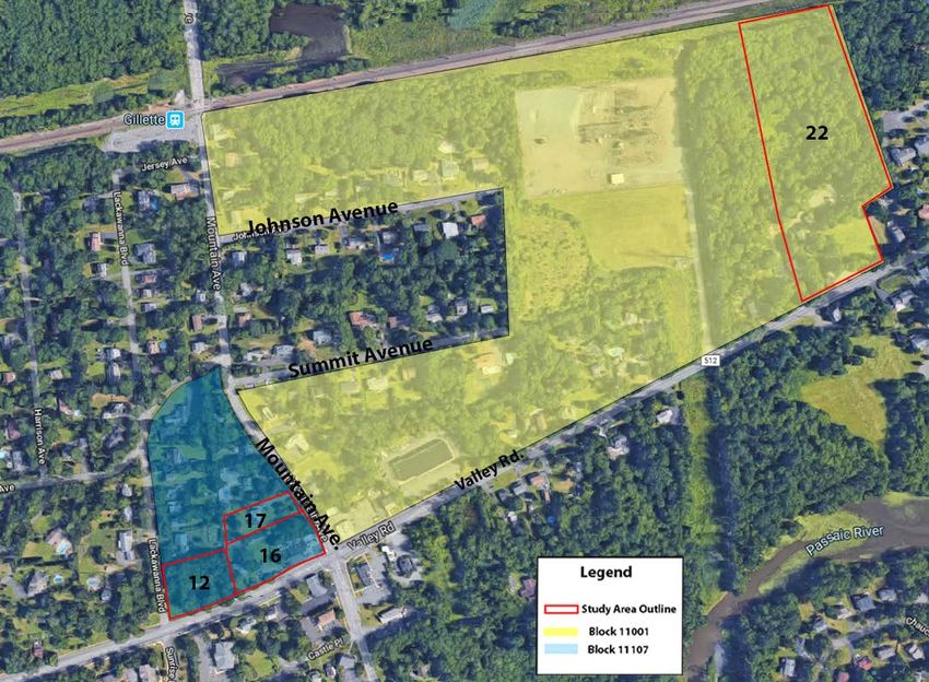
Acknowledgments:

                                PLANNING BOARD

                                J. Alan Pfeil, Chair

                            David Hands, Vice-Chair

                     Bruce Meringolo, Township Committee

                       Brendan Rae, Township Committee

                                   John Falvey

                                  Thomas Jones

                                 Tom Malinousky

                           Don Richardson (Recused)

                                 Dennis Sandow

                               PROFESSIONAL STAFF

                      Jolanta Maziarz, Esq. Board Attorney

                 Richard Keller, P.E., P.P., C.M.E., Board Engineer

                  Jessica Caldwell, P.P., A.I.C.P., Board Planner

                       Debra Coonce, Board Administrator

The original of this report was signed and sealed in accordance with N.J.S.A. 45:14A-12.

                                                        Jessica C. Caldwell, P.P., A.I.C.P.

                                                  New Jersey Professional Planner #5944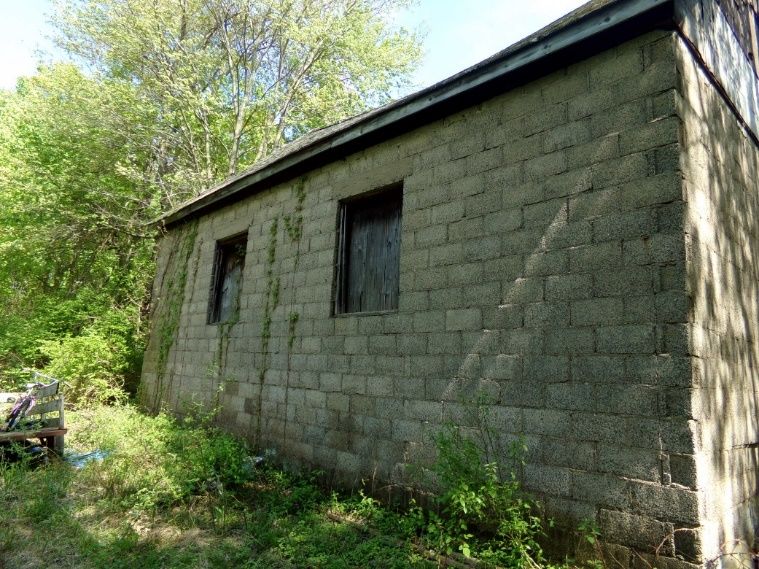
TABLE OF CONTENTS

1. INTRODUCTION .....................................................................................................................................................1

     1.1 Background .....................................................................................................................................................1

2. Local Redevelopment and Housing Law......................................................................................................4

     2.1 Chapter 12A Local Redevelopment & Housing Law (LRHL) ..............................................................4

     2.2 Process for Determination as a Redevelopment Area .......................................................................5

     2.3 Benefits of an Area in Need of Redevelopment ..................................................................................7

     2.3 Criterion for Area in Need ...........................................................................................................................8

3.       Overview of the Study Area .......................................................................................................................10

     3.1         Description ..............................................................................................................................................10

     3.2         Existing Land Use ...................................................................................................................................13

     3.3         Improvement Value to Land Value Analysis .................................................................................15

     3.3         Zoning Analysis .......................................................................................................................................16

     3.4         Relationship to Master Plan ................................................................................................................18

     3.5         Zoning Violations ...................................................................................................................................19

     3.6         Police Reports ........................................................................................................................................20

4. Criteria Compliance Analysis..........................................................................................................................22

5. Conclusion ...........................................................................................................................................................26

6. Appendix A – Site Photos .................................................................................................................................27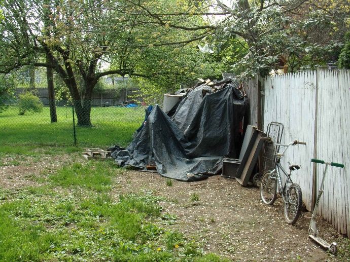
1. INTRODUCTION

1.1 BACKGROUND

On March 13, 2019, the Governing Body of the Township of Long Hill authorized the Planning
Board to conduct a Non-Condemnation Area in Need of Redevelopment Study via Resolution
Number 19-100. The Study Area is identified as Block 11001, Lot 22 and Block 11107, Lots 12,16,
and 17 on the official tax maps of the Township (the “Study Area”).

The Study Area includes 11.16 acres located in the southeast section of the Township along
Valley Road. The Study Area includes four (4) lots in two (2) Tax Blocks: Block 11001 and Block
1107. Block 11001, Lot 22 fronts on Valley Road with the nearest intersection being Mountain
Avenue and Valley Road. The NJ Transit Commuter Rail line for Gillette is located directly north
of the Study Area.

Block 11001, Lots 12, 16 and 17, front on Valley Road, Mountain Avenue, and Lackawanna
Boulevard. The site boundaries for this Study Area are Lackawanna Boulevard on the western
half and Mountain Avenue on the eastern half of the Study Area. The NJ Transit Commuter
Rail Station for Gillette is located directly north of the Study Area.

The purpose of this study is to determine whether the Township should designate all or a portion
of the Study Area as a Non-Condemnation Area in Need of Redevelopment under the Local
Redevelopment and Housing Law (LRHL), N.J.S.A 40A:12A-1 et seq.

The Township Resolution 19-100 also requires that the preliminary investigation of the Study
Area be undertaken within the context of a “Non-Condemnation” Redevelopment Area.
Meaning that if the Study Area is determined to be an Area in Need of Redevelopment under
LRHL, it shall be given a redevelopment designation. However, due to the non-condemnation
designation, the municipality will not have the statutory authority to exercise the power of
eminent domain to acquire property in the designated area.

This report will describe whether the Study Area qualifies as a “Redevelopment Area” under
the requirements set forth. The analysis presented in this report is based upon an examination
of existing conditions, site inspections, review of tax data, land uses, zoning ordinances, master
plan goals and objectives, and a history of each site pertaining to zoning violations and police
records as they relate to the statutory “Area in Need of Redevelopment” criteria.

Section 1: Introduction                                                                    Page 1
Study Area Map

Section 1: Introduction                    Page 2
Tax Block Map

Section 1: Introduction                   Page 3
2. LOCAL REDEVELOPMENT AND HOUSING LAW

2.1 CHAPTER 12A. LOCAL REDEVELOPMENT AND HOUSING LAW (LRHL)

The LRHL was developed by the New Jersey State Legislature to provide tools to municipalities
to promote the process of redevelopment and rehabilitation as follows:

“There exist, have existed and persist in various communities of this State conditions of
deterioration in housing, commercial and industrial installations, public services and facilities
and other physical components and supports of community life, and improper, or lack of
proper, development which results from forces which are amenable to correction and
amelioration by concerted effort of responsible public bodies, and without this public effort
are not likely to be corrected or ameliorated by private effort.”

The Legislature has, by various enactments, empowered and assisted local governments in
their efforts to revitalize their communities through redevelopment, rehabilitation, and
incentives for the expansion and improvement of commercial, industrial, residential and civic
facilities.

Section 2: Local Redevelopment & Housing Law                                              Page 4
2.2 PROCESS FOR DETERMINATION AS A REDEVELOPMENT AREA

The following process must be followed in order to designate an area in need of
redevelopment (N.J.S.A.40A:12A-6):

a.     The Governing Body adopts a resolution authorizing the Planning Board to undertake
       a preliminary investigation of a proposed area to determine if the area is in need of
       redevelopment. The resolution must designate whether the area being considered is
       proposed as a “Condemnation Redevelopment Area” or a “Non-Condemnation
       Redevelopment Area”. The Condemnation Redevelopment Area permits the
       Governing Body to use the power of eminent domain in a designated redevelopment
       area. The Non-Condemnation Redevelopment area does not permit the Governing
       Body to use the power of eminent domain in a designated redevelopment area. The
       Governing Body forwards a map of the proposed Study Area to the Planning Board.

b.     The Planning Board “prepares” a map and appends a statement setting forth the basis
       for the investigation. This must be on file with the Municipal Clerk.

c.     A study of the proposed area in need of redevelopment is prepared for review by the
       Planning Board.

d.     The Planning Board sets a date for a public hearing on the proposed designation of
       the proposed area and provides notice and opportunity for the public and those that
       would be affected by the determination to provide input on the proposed
       designation. The hearing notice must identify the general boundaries of the area and
       that a map is on file with the municipal clerk for public inspection. The hearing notice
       must also identify whether the area is being considered as a condemnation or non-
       condemnation redevelopment area. The notice must be published once per week for
       two weeks prior to the hearing in the newspaper of record. The notice must also be
       mailed to all property owners in the Study Area and anyone who has expressed
       interest in the designation.

e.     After completing the hearing, the Planning Board makes a recommendation to the
       Governing Body whether the area, in whole or in part, should be designated as an
       area in need of redevelopment.

f.     The Governing Body, after receiving the recommendation from the Planning Board,
       may adopt a resolution determining that the delineated area, in whole or in part, is
       designated as an area in need of redevelopment.

g.     The Clerk must transmit a copy of the resolution to the Commissioner of the State
       Department of Community Affairs (NJDCA) for review and approval. If the area in
       need of redevelopment is situated in an area where development or redevelopment
       is to be encouraged pursuant to State law or regulation then the determination shall
       take effect upon transmittal to NJDCA. Otherwise, the NJDCA has 30 days to approve
       or disapprove the area. If NJDCA does not respond in 30 days, the area is approved.

Section 2: Local Redevelopment & Housing Law                                            Page 5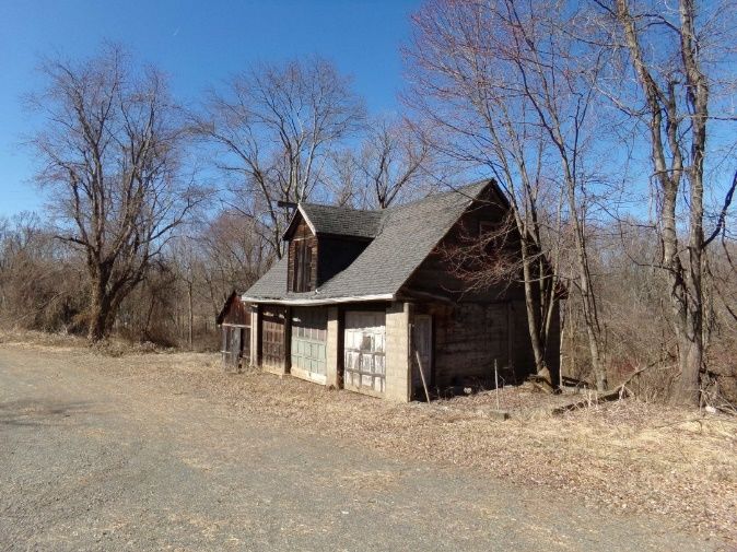
h.     Notice of the determination must be provided to all property owners within the
       delineated area within 10 days of the determination. If the area was determined to
       be a condemnation area the following language must be in the notice:

       (i)     The determination operates as a finding of public purpose and authorizes the
               municipality to exercise the power of eminent domain to acquire property in
               the redevelopment area; and

       (ii)    legal action to challenge the determination must be commenced within 45
               days of receipt of the notice and that failure to do so shall preclude an owner
               from later raising such a challenge.

I.     Following the 45-day appeal period and approval or no comment from NJDCA, then
       the area is designated as a redevelopment area and the municipality may exercise
       all of the powers set forth in the LRHL.

j.     In order to carry out the redevelopment of the site, a redevelopment plan must be
       adopted by the Governing Body. The plan may be prepared by the Governing Body
       and adopted pursuant to an ordinance with a referral to the Planning Board.
       Alternatively, the Governing Body may ask the Planning Board to prepare the plan,
       after which the Governing Body may adopt the plan pursuant to an ordinance.

k.     The Redevelopment Plan, once adopted, acts as the zoning on the site.

Section 2: Local Redevelopment & Housing Law                                           Page 6
2.3 BENEFITS OF AREA IN NEED OF REDEVELOPMENT

The LRHL is essentially a planning and financial tool that allows a redevelopment area to be
overlain with specific zoning and other incentives to stimulate the area’s redevelopment or
rehabilitation. More specifically, a redevelopment designation allows the municipality to,
among other things:
a.     Adopt a redevelopment plan that will identify how an area will be developed,
       including its use.

b.     Clear an area, install, construct or reconstruct streets, facilities, utilities, and site
       improvements.

c.     Negotiate and enter into contracts with private redevelopers or public agencies for
       the undertaking of any project or redevelopment work.

d.     Issue bonds for redevelopment.

e.     Acquire property (condemnation redevelopment area only).

f.     Lease or convey property without having to go through the public bidding process.

g.     Grant tax exemptions and abatements.

As such, the Township can utilize the powers granted to municipalities under the LRHL to
improve the existing conditions of the Study Area.

     1. The redevelopment plan for the area can be developed specifically for the area and
        even for a specific project.

     2. The redevelopment authority may provide long term tax abatements on
        improvements to the site and may also create a payment instead of Taxes or Pilot for
        the area.

     3. The redevelopment authority may issue Redevelopment Area Bonds to assist in
        financing development of the site.

     4. The redevelopment authority may select a redeveloper for the site and enter into
        agreements and contracts with the redeveloper in support of effectuating the
        redevelopment.

Section 2: Local Redevelopment & Housing Law                                             Page 7
2.3 CRITERION FOR AREA IN NEED
Under N.J.S.A 40A:12A-5, for an area to be found in need of redevelopment, the proposed
area must meet any one (1) of the eight (8) criteria listed below:
a. The generality of buildings are substandard, unsafe, unsanitary, dilapidated, or
obsolescent, or possess any of such characteristics, or are lacking in light, air, or space,
as to be conducive to unwholesome living or working conditions.
b. The discontinuance of the use of buildings previously used for commercial,
manufacturing, or industrial purposes; the abandonment of such buildings; or the
same being allowed to fall into so great a state of disrepair as to be untenantable.
c. Land that is owned by the municipality, the county, a local housing authority,
redevelopment agency or redevelopment entity, or unimproved vacant land that has
remained so for a period of ten years prior to adoption of the resolution, and that by
reason of its location, remoteness, lack of means of access to developed sections of
the municipality, or topography, or nature of the soil, is not likely to be developed
through the instrumentality of private capital.
d. Areas with buildings or improvements which, by reason of dilapidation, obsolescence,
overcrowding, faulty arrangement or design, lack of ventilation, light and sanitary
facilities, excessive land coverage, deleterious land use or obsolete layout, or any
combination of these or other factors are detrimental to the safety, health, morals or
welfare of the community.
e. A growing lack or total lack of proper utilization of areas caused by the condition of
the title, diverse ownership of the real properties therein or other similar conditions
which impede land assemblage or discourage the undertaking of improvements,
resulting in a stagnant and unproductive condition of land potentially useful and
valuable for contributing to and serving the public health, safety and welfare, which
condition is presumed to be having a negative social or economic impact or
otherwise being detrimental to the safety, health, morals or welfare of the surrounding
area or the community in general.
f. Areas, in excess of five contiguous acres, whereon buildings or improvements have
been destroyed, consumed by fire, demolished or altered by the action of storm, fire,
cyclone, tornado, earthquake or another casualty in such a way that the aggregate
assessed value of the area has been materially depreciated.
g. In any municipality in which an enterprise zone has been designated pursuant to the
“New Jersey Urban Enterprise Zones Act, “P.L.1983, c303 (C.52:27H-60 et seq.) the
execution of the actions prescribed in that act for the adoption by the municipality
and approval by the New Jersey Urban Enterprise Zone Authority of the zone
development plan for the area of the enterprise zone shall be considered sufficient for
Section 2: Local Redevelopment & Housing Law Page 8the determination that the area is in need of redevelopment pursuant to sections 5
and 6 of P.L.1992, C.79 (C.40A:12A-5 and 40A:12A-6) for the purpose of granting tax
exemptions within the enterprise zone district pursuant to the provisions of P.L.1991,
c.431(C.40A:20-1et seq.) or the adoption of a tax abatement and exemption
ordinance pursuant to the provisions of P.L.1991, c441(C.40A:21-1 et seq.). The
municipality shall not utilize any other redevelopment power within the urban
enterprise zone unless the municipal governing body and planning board have also
taken the actions and fulfilled the requirements prescribed in the P.L. 1992, C.79
(C.40A:12A-1 et al.) for determining that the area is in need of redevelopment or an
area in need of rehabilitation and the municipal governing body has adopted a
redevelopment plan ordinance including the area of the enterprise zone.
h. The designation of the delineated area is consistent with smart growth planning
principals adopted pursuant to law or regulation.
In addition to the above criteria, Section 3 of the LRHL allows the inclusion of parcels
necessary for the effective redevelopment of the area, by defining an area in need of
redevelopment as follows:
“(A) redevelopment area may include lands, buildings, or improvements which of
themselves are not detrimental to the public health, safety or welfare, but the inclusion
of which is found necessary, with or without change in their condition, for the effective
redevelopment of the area in which they are a part.”
Section 2: Local Redevelopment & Housing Law Page 93. OVERVIEW OF THE STUDY AREA
3.1 DESCRIPTION
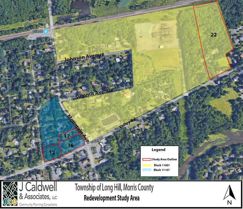
The Study Area includes four (4) lots covering 11.165 acres. The lots are Lot 22, Block 11001
and Lots 12,16 and 17, Block 11107. The Study Area is located along Valley Road, which is the
Township’s main commercial corridor. Blocks 11001 and 11107 are generally commercial or
mixed-use along Valley Road, with residential uses north and south of Valley Road. The Study
Area is directly south of the Gillette Rail Line and Rail Station with commuter train service within
walking distance of the Study Area.
# Block Lot Acerage (ac.) Owner
1 11107 12 .82 SIX HUNDRED NINETY VALLEY
ROAD LLC
2 11107 16 1.2 SIX SIX FOUR- SIX SEVEN SIX
VALLEY ROAD LLC
3 11107 17 0.851 FIVE HUNDRED SIX MOUNTAIN
AVENUE LLC
4 11001 22 8.2937 488- 490 VALLEY ROAD LLC
Total Acreage 11.1647
Source: NJCTB- New Jersey Association of County Tax Boards.
Section 3: Study Area Page 10The Study Area is developed with a mix of uses including a gas station/auto repair shop, former retail store,landscaping business and residential housing. The former retail store has an apartment above it and an additional residence behind it on the property. Other residential structures appear to either be single family residential, two-family or informal multi- family residential. The study area is located in the Gillette section of Long Hill Township. Each parcel within the Study Area is described below: 1. Block 11107, Lot 12: 690 Valley Road This 0.82-acre parcel is a corner lot located on the eastern side of the intersection of Valley Road and Lackawanna Boulevard. The property is owned by SIX HUNDRED NINETY VALLEY ROAD LLC and is developed as a two- family residence. The residence is approximately 1,874 sq ft and was built in 1950. Currently the residence is renter- occupied. 2. Block 11107, Lot 16: 664-676 Valley Road This 1.2-acre property is located on the northwestern corner of the intersection of Valley Road and Mountain Avenue with approximently four buildings on the lot. The property is owned by SIX SIX FOUR- SIX SEVEN SIX VALLEY ROAD LLC. The site is developed as a Valero Gas Station, residential structure, two accessry storage structures. The residence was built in 1920. Currently, the property has an active gas station, a landscaping business consisting of storage of vehicles and equipment and a residential use that appears to be multiple units within a former single family residence. Section 3: Study Area Page 11
3. Block 11107, Lot 17: 506
                                         Mountain Ave.

                                         This parcel is owned by FIVE
                                         HUNDRED SIX MOUNTAIN
                                         AVENUE LLC. This 0.851-acre
                                         lot is currently developed as
                                         a residential use. The home is
                                         approximately 1,614 sq ft
                                         and built in 1955. There are
                                         numerous       vehicles   (7+)
                                         parked at the residence in
                                         both the driveway and on
                                         the grassy areas of the lot
                                         indicating           potential
                                         crowding or multi-family use.

4. Block 11001, Lot 22: 488 Valley
Rd.

This parcel is owned by 488- 490
VALLEY ROAD LLC. The property is
developed with a small mixed-use
building in front of the property and
a residential structure and garage
to the rear of the property. The three
buildings on the property were built
in 1940. The lot size is approximately
8.29 acres. This mixed-use structure
along Valley Road has an occupied
residential     apartment.         The
commercial use is vacant. The
residence and garage to the rear of
the property are vacant.

Section 3: Study Area                                          Page 12
3.2 EXISTING LAND USE
The Study Area includes four (4) tax lots, covering an area of 11.1647 acres. The uses in the
Study Area include mixed-use, residential and commercial uses.
# Block Lot Acreage ( ac.) Land Use
1 11107 12 .82 Residential – Two- Family
2 11107 16 1.2 Commercial /Residential
3 11107 17 0.851 Residential
4 11001 22 8.2937 Commercial/ Residential
Total Acreage 11.1647 acres
Land uses in the Study Area fall into the following categories:
1. Approximately 75 percent of the Study Area is comprised of single-family/ multifamily
residential uses, including Lots 12, 16 and 17, Block 11107. Some form of residential
use exists on all of the parcels in the Study Area.
2. About 25 percent of the Study Area is comprised of commercial uses. This includes
portions of Lot 16, Block 11107 and portions of Lot 22, Block 11001. Lot 16, which is in
this commercial area, is occupied by a gas station. The site also has a car repair shop
in connection with the gas station. Additionally, a landscape business has multiple
trucks, equipment and materials stored on the site with the gas station.
Environmental Issues on Site
On December 11, 2018, Lot 16 also known as the Valero Gas Station, was reviewed by EWMA
as part of a site remediation study. The study was conducted to examine if soil contamination
from previous leaking tanks was continuing to impact groundwater. The study concluded that
soil contamination was no longer negatively affecting the ground water, but further
monitoring should be maintained. Also, any future development on the site should take into
consideration the potential vapor intrusion from the groundwater contamination.
Section 3: Study Area Page 13Land Use Map Section 3: Study Area Page 14
3.3        IMPROVEMENT VALUE TO LAND VALUE ANALYSIS

In order to determine the economic productivity of properties within the Study Area, tax
assessment data was analyzed to determine the ratio of the improvement value to land value
on each lot. This ratio can help identify properties that are underutilized. The table contains
the information taken from the Township’s tax records which include building descriptions,
land values, property improvement costs and the values of the total properties.

An improvement to land value ratio of 1:1 or less suggests that the “land is not currently
supporting a reasonable value of improvements”, and, as such, is underutilized1.             An
improvement value of less than 2:1 also can identify parcels that are underbuilt for the area,
particularly in a central business district. Properties with improvement values that are equal to
or greater than the land value indicate healthy economic productivity. Properties where the
land is worth more than the improvements often indicate that the improvements are old,
obsolete and/or deteriorated so that they depreciate, rather than appreciate, in value as
would be the case with economically productive properties.

    Lot     Land Value        Improvement              Total              Improvement to Land
                                  Value                Value                     Ratio
    12     190,800         172,300                  363,100                      0.9 :1
    16     600,000         470,000                  1,070,600                   0.78 :1
    17     216,000         179,500                  395,500                     0.83 :1
    22     623,000         27,000                   650,000                     0.043 :1

The four (4) parcels above have an improvement value to land value ratio of 1:1 or less and
are located within the Gillette community in Long Hill Township. The four (4) parcels of land
are also within 1/3 mile of the Gillette Train Station. The improvement to land value ratios
above indicate underutilization of the properties.

1
    (The Redevelopment Handbook: A Guide to Rebuilding New Jersey’s Communities, 2012. Pg. 64
Section 3: Study Area                                                                           Page 15
3.3 ZONING ANALYSIS
Of the four (4) lots in the Study Area, two (2) are zoned R-3, one (1) is zoned B-1-20, and one
(1) is zoned R-4.
# Block Lot Zone
1 11107 12 R-3
2 11107 16 B-1-20
3 11107 17 R-3
4 11001 22 R-4
Section 3: Study Area Page 16Zoning Description B-1-20 Village Business Zone B-1-20 Village Business Zones are located in various locations along Valley Road and allow retail trade and retail services, business and professional offices, restaurants, financial institutions, apartments, child care centers and similar uses. Conditional uses include public institutional uses, public utilities, outdoor dining and drive-up windows for pharmacies. R-3 Residential Zone R-3 Residential Zones are the prevailing zoning classification within the municipality. The Zone is intended to accommodate residential development on 30,000 square foot lots. The R-3 Zone primarily permits residential including single-family, community residences and community shelters, density modification subdivisions and lot dimension modification subdivisions. Accessory uses include home offices, senior suites, accessory apartments, keeping of livestock and other customary uses. Conditional uses include public institutional uses and public utilities. R-4 Residential Zone The R-4 District is intended to accommodate residential development on lots 20,000 square feet or greater. The R-4 Zone primarily permits residential including all of the uses in the R-3 Residential Zone and also includes Planned Senior Residential Communities. Section 3: Study Area Page 17
3.4       RELATIONSHIP TO MASTER PLAN

Enhancement of Long Hill’s downtown has been an ongoing effort for the Township. The
Township’s most recent Master Plan Reexamination was adopted in 2013. A Downtown
Valley Commercial District Element was adopted in 2015. The 2015 Downtown Valley
Commercial District Element noted the following: “The vision for downtown Long Hill is that of
a vibrant hub of community activity. We envision a future in which the area is highly
accessible to pedestrians through connecting pathways and sidewalks. Downtown will be a
place where people will come to stroll, shop, work, attend cultural and entertainment events,
enjoy food and drink, and conduct civic and other business activities. Downtown should be
planned to strengthen its role as an economically sustainable commercial center that
provides many of the goods and services that Township residents need on a daily basis and
also is a magnet to people from the surrounding region.”

The Study Area is adjacent to the proposed downtown areas and redevelopment of such
would augment Land Use Goals in the Master Plan as follows:

Land Use Goals:

1. Make walkable neighborhoods a priority within Long Hill Township, including, but not limited
to these criteria:

      •   A Center: Walkable neighborhoods have a center, whether it's the main street or a
          public space.
      •   People: Enough people for businesses to flourish.
      •   Public Transportation: Access to public transit to serve the needs of local residents and
          visitors.
      •   Parks and Public Space: Adequate public places for people to gather and play.
      •   Pedestrian Design: Buildings are close to the street; parking lots are relegated to the
          back.
      •   Neighborhood-Related Businesses: Uses that meet the shopping, social, and dining
          needs of local residents while also attracting out-of-town consumers and patrons.

2. Encourage the development of these walkable areas in ways that meet accepted
walkability standards via sidewalk access: a ¼ mile radius includes fundamental lifestyle
necessities; ½ mile radius (10-minute walk) provides access to active and passive recreation.

3. Encourage commercial uses related explicitly to lifestyle preferences of both older residents
who want to retire in place and younger residents seeking walkable neighborhood housing.
Define new zoning districts that more closely align existing uses with desired future uses,
notably the intent to foster walkable mixed use residential and commercial neighborhoods.

The Master Plan recommends creating a General Business District along Valley road which
will connect Stirling Village, Millington Village and Gillette. The goal is to combine portions of
the B-2, B-3, L1-2 and O zones along Valley Road into a new Business Downtown Zone (B-D)
which will allow office, commercial and retail uses.

Section 3: Study Area                                                                      Page 18
3.5 ZONING VIOLATIONS
Zoning violations in the Study Area were analyzed to determine if property
maintenance and land use violations were an issue in the area. Several zoning and
property maintenance violations have been issued within the Study Area. A lot by lot
analysis shows that all four (4) of the lots have had property maintenance and zoning
violations.
Block 11107, Lot 12: The property received a formal complaint on the number
of bulk items left out in front of the property.
Block 11107, Lot 16: The property received a zoning violation for changing the
sign with no formal approval from a non-digital sign to a digital sign for gas
prices. The sign was later changed back to a non-digital sign. The property
received a property maintenance report for the illegal storage of commercial
vehicles on the property (Landscape service trucks).
Block 11107, Lot 17: The property received a noise ordinance violation from a
neighbor about a generator running full time. The noise exceeded the
acceptable hours from 7 am to 8 pm. The property also received a violation
for having too many cars permanently parked on the driveway.
Block 11001, Lot 22: The property received a zoning violation for an illegal pile
of debris left on the side of the lot (this included wood pallets and garbage).
The property also received a violation for hosting a sidewalk sale on the
property which was not approved for by the Township.
Property Maintenance & Zoning Violations by Lot
# Block Lot Prop. Zoning
Maint.
1 11107 12 1 0
2 11107 16 1 1
3 11107 17 1 1
4 11001 22 2 1
Section 3: Study Area Page 193.6 POLICE REPORTS
CASE NUMBER DATE/TIME INCIDENT
488 VALLEY RD / 490 VALLEY RD
2014-01794 2/11/14 16:33 Verbal dispute between two parties involving rent
664 VALLEY RD / 670 VALLEY RD
2019-05690 4/2/19 7:27 Concerned motorist observed a slowly-driving car stop at a location
2019-04239 3/7/19 3:58 A motorist ran out of gas at the location
2019-00054 1/2/2019 2:46 Burglar alarm activation
2018-14089 9/14/2018 2:44 The suspicious vehicle pulled into closed business
2018-13464 9/2/2018 1:59 Police assistance to motorist
2018-12574 8/16/2018 23:17 Police assistance to motorist
2018-11767 8/1/2018 15:29 Motor Vehicle Accident
2018-09405 6/20/2018 7:52 Welfare check
2018-03503 3/7/2018 15:56 Disabled motor vehicle
2018-02903 2/23/2018 17:46 Credit card charge dispute
2018-00208 1/16/2018 5:31 Motorist assistance
2017-17932 10/24/2017 19:38 Motorist assistance
2017-16356 9/28/2017 17:32 Motor Vehicle Accident
2017-09869 6/11/2017 4:59 Investigation of two subjects lying on the ground of premises
2017-08049 5/13/2017 19:15 Burglar alarm activation
2016-19252 11/23/2016 9:53 Motor Vehicle Accident
A passerby called out of concerned for motorist having difficulty
2016-18977 11/19/2016 11:06 driving
2016-15698 9/27/2016 17:38 Reported suspicious male
2016-13638 8/23/2016 6:58 Motor Vehicle Accident (occurred at the intersection, not on property)
2016-07226 5/6/2016 8:45 Motor Vehicle Accident (occurred at the intersection, not on property)
2016-02040 2/9/2016 23:22 Reported suspicious vehicle
Patrol located the suspicious van. Occupants leaving keys/note for car
2015-17771 12/8/15 10:24 repairs
2015-10045 7/11/15 22:26 Suspicious vehicle
2015-09107 6/21/2015 0:29 Suspicious vehicle
2015-05664 4/17/2015 15:25 Disabled motor vehicle
2015-05586 4/16/2015 10:18 Motor Vehicle Accident (occurred @ intersection, not on property)
2015-02014 2/8/2015 23:47 Response to possible reported fire was steam from the furnace.
506 MOUNTAIN AVE
2017-013544 8/12/2017 0:26 Noise complaint in reference to loud music
Section 3: Study Area Page 20690 VALLEY
RD
The juvenile arrest of a subject who had left custody without
2018-19412 12/24/2018 20:12 permission
2018-16368 10/25/2018 6:23 Patrol located a reported missing juvenile
2018-05247 4/5/2018 23:20 Juvenile arrested for possession of CDS
2018-00752 1/16/2018 18:26 Patrol located two reported missing juveniles
2017-16111 9/24/2017 21:36 Noise complaint in reference to a party taking place on premises
2016-02310 2/29/2016 17:26 Homeowner reports in-laws improperly removing items from home
2016-02837 2/22/2016 21:57 Suspect arrest for aggravated sexual assault
The police reports and zoning/maintenance violations provided for the Study Area indicate
potential issues relative to overcrowding, illegal land uses, attractive nuisances, disruptive and
criminal behavior occurring within the Study Area.
Section 3: Study Area Page 214. CRITERIA COMPLIANCE ANALYSIS An analysis of the Study Area’s existing land use, site layout, and physical characteristics was conducted using tax records, a physical inspection of the Area, review of aerial photographs, Master Plan studies and maps, and other municipal records. This section summarizes findings for the Study Area according to the following criteria from N.J.S.A 40A:12A-5 to determine whether the Study Area should be designated as an Area in Need of Redevelopment: The criterion “a”: Deterioration (N.J.S.A. 40A;12A-5.a) The generality of buildings are substandard, unsafe, unsanitary, dilapidated, or obsolescent, or possess any of such characteristics, or are lacking in light, air, or space, as to be conducive to unwholesome living or working conditions. The following properties within the Study Area were found to meet Criterion “a” for deterioration: Block 11001, Lot 22 and Block 11107, Lot 16. The four (4) buildings on Lot 22 have dilapidated siding, chipping paint, sagging and broken gutters, deteorating interiors, broken pipes, leaking roofs and a host of other issues that point to substandard and dilapidated conditions. Two of the four structures also have boarded up windows, outdoor storage of debris and trash. The vacant residence and barn to the rear of the property are vacant and in unsafe conditions for habitation. Of the four structures, only the apartment over the vacant commercial space is occupied. All other spaces on the site are in disrepair and not habitable in their current condition. Block 11107, Lot 16 has structures in a state of dilapidation and disrepair. The two accessory structures have broken windows, broken siding and are filled with storage for the landscaping business. Lot 16 has a gas station and auto body repair, a residence, which appears to be used as mult-family apartment and two accessory structures on one lot. The lot does not have connectivity between the uses and the uses do not correlate with each other. The illegal storage of landscaping vehicles and equipment is spread throughout the lot and in the residential parking area. Lot 16 displays dilapidation and obsolescence of uses. See Appendix A for site photos. Criterion “b”: Abandonment (N.J.S.A. 40A:12A-5. b) The discontinuance of the use of buildings previously used for commercial, manufacturing, or industrial purposes; the abandonment of such buildings; or the same being allowed to fall into so great a state of disrepair as to be untenantable. The following property was found to meet Criterion “b”: Block 11001, Lot 22. All four (4) structures on the property display vacancy and abandonment. Of the four structures on the property, only the apartment over the commercial use is occupied. The remainder of the property is not occupied and has been allowed to fall into so great a state of disrepair as to be untenantable. The commercial space has broken pipes, broken sheetrock, broken ceiling tiles and mold. The residence, barn and garage all display disrepair, broken siding, windows, leaking roofs, molding, piled up garbage and rodent infestations. See Appendix A for site photos. Section 4: Criteria Analysis Page 22
Criterion “d”: Obsolete Layout and Design (N.J.S.A. 40A:12A-5.d) Areas with buildings or
improvements which, by reason of dilapidation, obsolescence, overcrowding, faulty
arrangement or design, lack of ventilation, light and sanitary facilities, excessive land
coverage, deleterious land use or obsolete layout, or any combination of these or other
factors are detrimental to the safety, health, morals or welfare of the community.

The following properties were found to meet Criterion d: Block 11001, Lot 22 and Block 11107,
Lot 16.

Lot 22 has a mixed-use building very close to the road with no room for improviing the road
frontage, The parking area for the mixed-use building is sloping and in poor condition.
Additional structures are setback on the property such that there is no cohesiveness of uses
and structures on the site. The combination of structures is haphazard and the layout is faulty.
The proximity of the mixed-use structure to the road is not conducive to frontage
improvements on the road. The combination of these factors is deterimental to the health,
safety and welfare of the community.

Lot 16 is developed with a gas station/auto repair shop, a storage yard, a residence and two
accessory storage structures. The layout and combination of the uses do not relate to each
other on the site. There is a landscaping business with storage of equipment behind the gas
station, in the residential parking area and storage in the accessory structures. There is no
connectivity between uses or structures. The gas station is small and outdated as to layout
and design. There is no canopy and circulation on the site is limited. The structure and pumps
are very close to the right of way. The gas station has had issues of groundwater
contamination that continues to require monitoring and vapor intrusion must be monitored
into the future. This points to a deleterious land use on the property. The combination of
these factors are detrimental to the health, safety and welfare of the community. See
Appendix A for site photos.

Criterion “e”: Property Ownership and Title Issues (N.J.S.A. 40A:12A-5.e) A growing lack or
total lack of proper utilization of areas caused by the condition of the title, diverse ownership
of the real properties therein or other similar conditions which impede land assemblage or
discourage the undertaking of improvements, resulting in a stagnant and unproductive
condition of land potentially useful and valuable for contributing to and serving the public
health, safety and welfare, which condition is presumed to be having a negative social or
economic impact or otherwise being detrimental to the safety, health, morals or welfare of
the surrounding area or the community in general.

This criterion is applicable in circumstances where there is quantifiable economic
underutilization or lack of proper utilization of properties in the Study Area. One of the
indicators used to measure the economic productivity of a property is the ratio of the
assessed value of the improvements on the property to the value of the land. Developed
properties in areas that are economically viable typically have improvement to land value
ratios of 2:1 or greater. Lower ratios may offer evidence of underutilization. An improvement
to land to value ratio of 1:1 or less represents strong evidence of underutilization.

Section 4: Criteria Analysis                                                             Page 23
To determine if there is evidence of underutilization or lack of proper utilization of the
properties, we have reviewed the tax records of each of the parcels. The following parcels
have a building to land value ratio of less than 1:1 Lots 12,16 and 17 in Block 1107, and Lot 22
in Block 11001. This improvement to land value ratio indicates that the properties are
underutilized for the area where they are located.          The commercial uses are not fully
functional. There is evidence of illegal land uses and non-conforming land uses on all of the
lots in the Study Area. The land is not currently supporting a reasonable value of
improvements, and, as such, is underutilized. For these reasons, the properties meet Criterion
e.

Criterion “h”: Smart Growth Consistency (N.J.S.A. 40A:12A-5.h) The designation of the
delineated area is consistent with smart growth planning principals adopted pursuant to law
or regulation.

This can be applied to the entire Study Area as a whole because the designation of the
delineated area is consistent with smart growth planning principles adopted pursuant to law
or regulation. Smart growth is defined as a planning principal that directs new growth to
locations where infrastructure and services are available, limits sprawl development, protects
the environment, and enhances and rebuilds existing communities. The New Jersey Office for
Planning Advocacy identifies the following as smart growth principles:

    •   Mixed Land Uses;
    •   Compact, Clustered Community Design;
    •   Walkable Neighborhoods;
    •   Distinctive, Attractive Communities Offering a “Sense of Place”;
    •   Open Space, Farmland and Scenic Resource Preservation;
    •   Future Development Strengthened and Directed to Existing Communities Using Existing
        Infrastructure;
    •   A Variety of Transportation Options;
    •   Community and Stakeholder Collaboration in Development Decision Making;
    •   Predictable, Fair and Cost-Effective Development Decisions; and
    •   A Range of Housing Choices.
The Study Area is located along the main commercial corridor in the Township and is within
walking distance to the Gillette Train Station. Designation of this area promotes further Smart
Growth principals including walkable neighborhoods and a variety of transportation options.
The properties within the Study Area meet the smart growth principal embodied in Criteria h,
which is that they are within an existing or near a downtown area, are contained in a
walkable area and provide for a variety of transportation options. To direct future
development towards existing infrastructure is one of the key principals of smart growth to
limit sprawl and preserve the environment. The train station is an existing piece of infrastructure
that is within walking distance to the study area. The close proximity of the Gillette Train Station
allows the study area to again fall into the smart growth principles.

Section 4: Criteria Analysis                                                                Page 24
Section 40A:12A-3: The Redevelopment Law definitions are in Section 3 of the
Redevelopment Law, which states following the definition of a Redevelopment Area that “a
redevelopment area may include lands, buildings or improvements which of themselves are
not detrimental to the public, health, safety or welfare, but the inclusion of which is found
necessary with or without change in their condition, for the effective redevelopment of the
area of which they are a part.”
The entirety of the area is needed for the effective redevelopment of the delineated area
because this area represents two key underutilized areas along Valley Road. The complete
street frontage provided by Lots 12, 16 and 17 along Valley Road provide a continuous
streetscape between Mountain Avenue and Lackawanna Road. The redevelopment of the
area as a whole would provide the most benefit to the health and general welfare of the
community and the region.
A summary of each lot and block and the redevelopment criteria met is shown in the table
below:
Redevelopment Criteria by Lot:
# Block Lot a b d e h 3
1 11107 12
2 11107 16
3 11107 17
4 11001 22
Section 4: Criteria Analysis Page 255. CONCLUSION This investigation and study find that each lot within the Study Area identified meets at least two or more of the statutory criteria, along with Section 3, to qualify as an Area in Need of Redevelopment and recommends that the Study Area be designated by the Township of Long Hill as a Non-Condemnation Area in Need of Redevelopment pursuant to N.J.S.A. 40A:12A-1 et seq. Section 5: Conclusion Page 26
6. APPENDIX A – SITE PHOTOS

Photos from Field Study:
Block 11001, Lot 22 / Block 11107, Lot 12, 16, 17
Block 11001, Lot 22:

In photo #1, one can observe the building having boarded up windows. Photo #2 shows the
possible contamination of asbestos. In photo #3, one can observe the holes in the ceiling
which indicate a leak in the ceiling. In photo #4, you can see the pipes of the building are
beginning to rust, causing possible leaks in the building. The commercial space has been
vacant for approximately 6 years.

1.                                          2.

3.                            4.

Appendix A: Photos                                                                  Page 27
Structure #2 As one can see in the following photos, the house is currently in a dilapidated
state with mold and dead rodents scattered throughout the space. In the last photo, one
can also observe what would seem to be a transient living condition with pillows and a
blanket.

Appendix A: Photos                                                                     Page 28
Structure #3

Appendix A: Photos   Page 29
Structure # 4 The barn/ garage structure is abandoned and in a dilapidated state. This
building is located in the rear of the study site bounded by wooded area and wetlands. As
one can see in image 3 the structure is collapsing and not habitable.

1.                                          2.

3.                               4.

Appendix A: Photos                                                                 Page 30
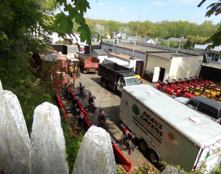
Block 11107, Lot 16:

This site is currently being used as a gas station/ auto body shop and a storage space for a
landscaping company. In the following photos, one can observe the eight commercial trucks
being kept on the property and approximately 20 snow plows at the rear of the building.
Based on prior violations, the storage of commercial vehicles is not allowed on the property.

Appendix A: Photos                                                                   Page 31
The following photos show the residential space on Lot 16. The two accessory buildings in
the back of the lot are boarded up with black tarps on the windows. The accessory
structures are used as storage facilities fpr the landscaping business. There is evidence of
multiple tenants in the residential structure. One can also observe a washing machine in
front of the building and a broken grill. The property shows multiple signs of neglect and
dilapidation.

Appendix A: Photos                                                                     Page 32
Photo #1 shows the four commercial vehicles parked on the residential area of Lot 16. Photo
#2 shows the multiple entrances to the residential house, indicating multiple tenants on the
property. Photos # 3, #4 show the two other structures on the property that are used for the
storage from the Landscape company.

1.                                       3.

2.                                       4.

Appendix A: Photos                                                                  Page 33
Block 11107, Lot 17:

Please see following photos for, Lot 17, Block 11107.

Appendix A: Photos                                      Page 34
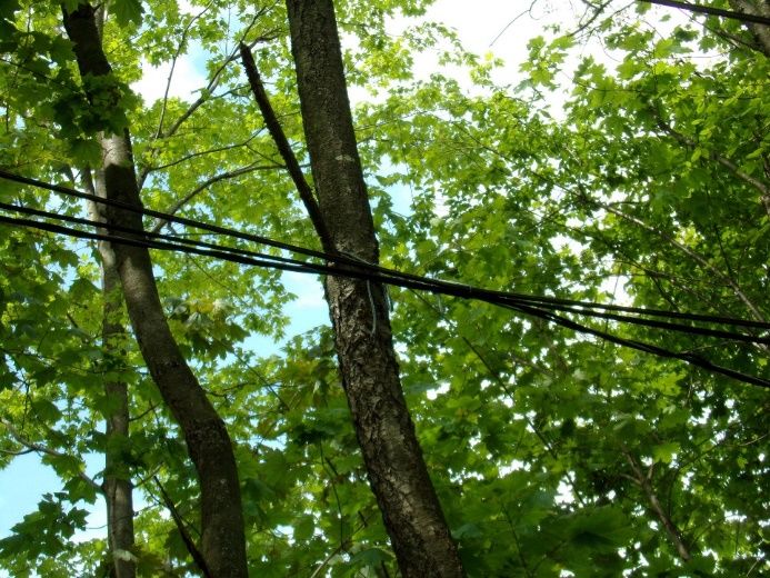
Block 11107, Lot 12:

Lot 12 is currently in a deteriorating state. The site also has electrical wires that are being
held together by strings connected to trees.

Appendix A: Photos                                                                          Page 35
You can also read