Twin Creek Wind Farm Bushfire Management Plan - June 2017 - SA ...
←
→
Page content transcription
If your browser does not render page correctly, please read the page content below
Twin Creek Wind Farm
Bushfire Management Plan

         June 2017

                           1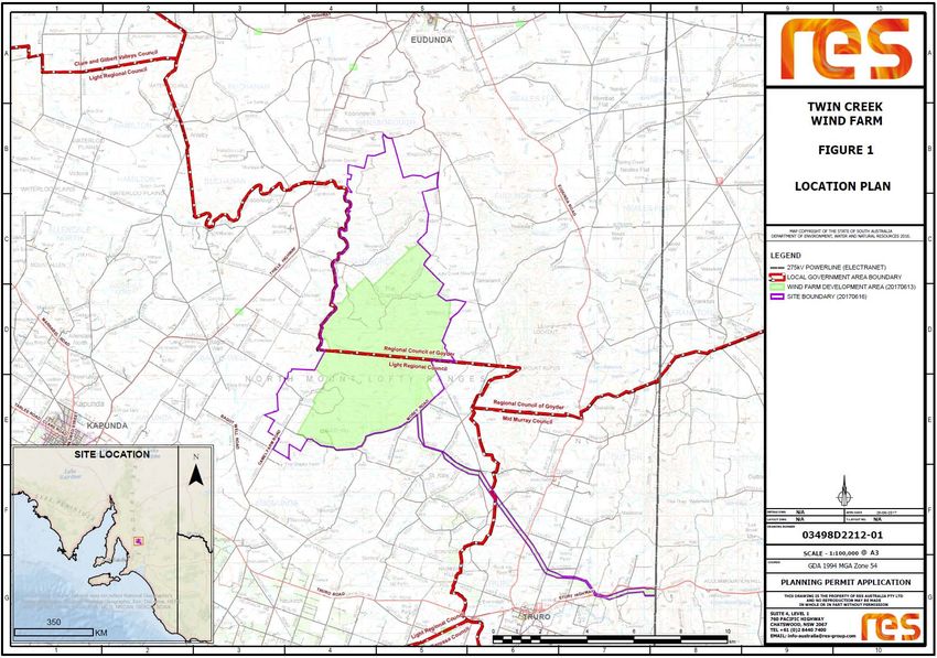
Disclaimer

Twin Creek Wind Farm Bushfire Management Plan has been produced by SA Bushfire Solutions.

Although every attempt has been made to ensure the contents of this assessment are as accurate as
possible, it must be acknowledged that over time, changes in environmental conditions and
government policy may affect the recommendations provided in this plan.

It should be noted that although reasonable steps have been taken to minimise this, SA Bushfire
Solutions accepts no responsibility for any damages that may result from the implementation of
recommendations from this assessment.

For clarification or further information, I invite you to contact:

Brett Stephens
Director
SA Bushfire Solutions
0427 604 253
bs_ps@outlook.com
www.sabushfiresolutions.com

                                                                                               2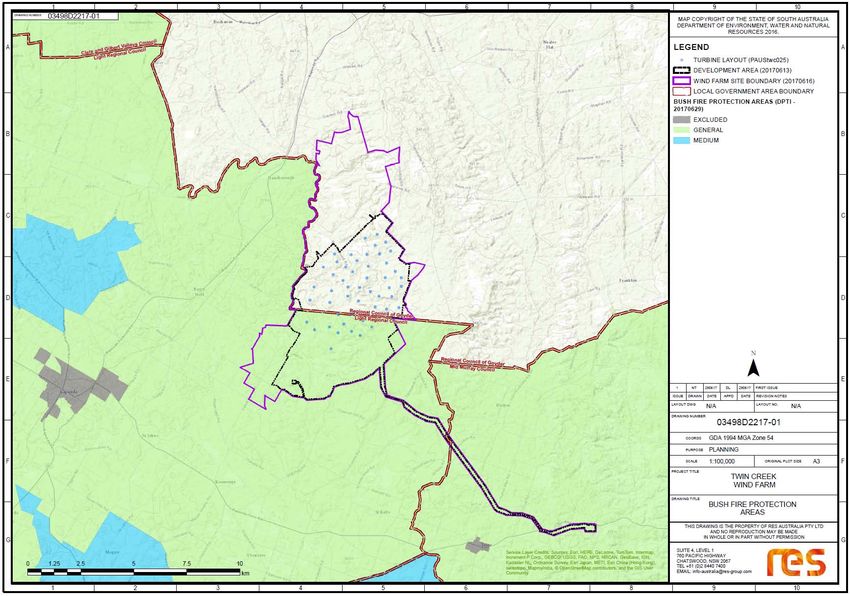
Executive Summary

The plan focuses specifically to the construction and operation of the proposed Twin Creek Wind
Farm, northern Mount Lofty Ranges, South Australia and defines objectives and recommendations
to mitigate the threat that bushfires pose to life, property, the environment and the potential
hindrance to suppression operations.

The plan makes recommendations that may support and guide management decisions to mitigate
potential bushfire risks.

The evaluation of bushfire risk is extremely complex due to the range of factors that may influence
potential outcomes. It is not feasible to undertake a risk assessment for every possible scenario
when so many variables can affect the possible likelihood and consequence.

Bushfire suppression is also a complex activity that requires involvement from a wide range of
stakeholders and it is important to note that no single approach, strategy or technique is
instrumental in the mitigation of risk or successful suppression operations at bushfires.

The proposed Twin Creek Wind Farm is largely located in an excluded bushfire risk area, with the
southern portion located in a general bushfire risk area largely due to the minimal vegetation and
low overall fuel hazard levels. It should be noted however that nearby locations have experienced
significant bushfires in recent years, notably Pinery 25th November 2015, Eden Valley 17th January
2014 and Angaston 16th December 2014.

The Twin Creek Wind Farm development will increase the number of turbine assets and associated
infrastructure in the local area. This may have potential to increase bushfire risk and impact
suppression operations, however, the risk from wind turbine fires is considered less than many other
activities expected in these rural environments. Fires starting from headers, vehicles and other
agricultural machinery, lightning and arson remain the greatest likelihood for bushfire ignitions in
this area.

The Twin Creek Wind Farm is located on areas of low fuels with undulating and rocky terrain, the
construction of vehicle and fire access tracks will improve emergency response and aid suppression
operations.

With the recommendations provided in this plan and suggested mitigation strategies in place it is
determined that the development of the wind farm will not significantly increase bushfire risk to the
landscape or prevent emergency service operations.

Finally, with an assumption that all land owners and contractors undertake works as per their legal
and/or contractual obligations and fire crew maintain a “safety first” approach to fire fighting it is
concluded that the development poses an acceptable low overall risk.

                                                                                                         3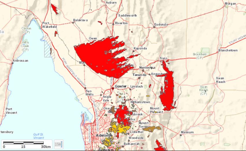
Contents
1.     INTRODUCTION .............................................................................................................................................. 6
     1.1       Purpose ................................................................................................................................................. 6
     1.2       Objectives.............................................................................................................................................. 6
     1.3       Fire Management Planning Framework ................................................................................................ 6
     1.4       Legislation ............................................................................................................................................. 6
       1.4.1           Fire and Emergency Services Act 2005 ......................................................................................... 6
       1.4.2           Local Government Act 1999 ......................................................................................................... 7
       1.4.3           State Emergency Management Act 2004 ..................................................................................... 7
     1.5       Other Relevant Legislation, Codes and Regulations.............................................................................. 7
     1.6       Existing Documents, Policies and Guidelines ........................................................................................ 8
       1.6.1           Country Fire Service - Bushfire Management Planning ................................................................ 8
       1.6.2           Code of Practice for Fire Management on Public Land in South Australia................................... 8
       1.6.3     Government Agencies Fire Management Working Group - Firebreaks, Fire Access Track and
       Sign Standards Guidelines. ............................................................................................................................. 9
       1.6.4           South Australian Country Fire Service ........................................................................................ 10
       1.6.5           Department of Environment, Water and Natural Resources (DEWNR) ..................................... 10
     1.7       Consultation ........................................................................................................................................ 13
     1.8       Review ................................................................................................................................................. 13
2      THE BUSHFIRE ENVIRONMENT .................................................................................................................... 14
     2.1       Location ............................................................................................................................................... 14
     2.2       Vegetation ........................................................................................................................................... 14
     2.3       Terrain ................................................................................................................................................. 14
     2.4       Surrounding Land Use ......................................................................................................................... 15
     2.5       Environment ........................................................................................................................................ 15
     2.6       Access and Egress ................................................................................................................................ 20
     2.7       Assets .................................................................................................................................................. 20
     2.8       Water Infrastructure ........................................................................................................................... 20
     2.9       Fire Weather ....................................................................................................................................... 20
       2.9.1           Extreme Fire Weather Conditions .............................................................................................. 20
     2.10      Climate Change and Bushfires ............................................................................................................ 21
     2.11      Fire History .......................................................................................................................................... 21
       2.11.1          Pinery Bushfire ........................................................................................................................... 22
       2.11.2          Eden Valley Bushfire ................................................................................................................... 22
       2.11.3          Angaston Bushfire ...................................................................................................................... 22
3      BUSHFIRE RISK ............................................................................................................................................. 24
     3.1       Bushfire Risks During Construction ..................................................................................................... 24
                                                                                                                                                                         4
3.2       Bushfire Risks During Operation ......................................................................................................... 24
    3.3       Potential Impacts on Bushfire Suppression Operations...................................................................... 25
      3.3.1           Aerial Suppression Considerations. ............................................................................................ 26
4     READINESS ................................................................................................................................................... 28
    4.1       Equipment ........................................................................................................................................... 28
    4.2       Training ............................................................................................................................................... 28
    4.3       Safe Work Procedures, Policies and Guidelines .................................................................................. 28
    4.4       Risk Mitigation Strategies ................................................................................................................... 29
      4.4.1           Fire Access Tracks ....................................................................................................................... 29
      4.4.2           Water Points ............................................................................................................................... 29
      4.4.3           Fire Management Zones ............................................................................................................. 29
5     RESPONSE .................................................................................................................................................... 30
    5.1       Suppression Considerations ................................................................................................................ 30
      5.1.1           Objectives for Fire Suppression .................................................................................................. 30
      5.1.2           Firefighters .....................................................................................Error! Bookmark not defined.
      5.1.3           Machinery Use............................................................................................................................ 31
      5.1.4           Water .......................................................................................................................................... 31
      5.1.5           Turbine Management ................................................................................................................. 31
      5.1.6           Stay informed ............................................................................................................................. 31
      5.1.7           Evacuation/Leaving Early ........................................................................................................... 31
    5.2       Response Plans .................................................................................................................................... 32
      5.2.1           Response Plan Contents ............................................................................................................. 32
6     RECOVERY .................................................................................................................................................... 32
7     RECOMMENDATIONS .................................................................................................................................. 35
    7.1       Recommendations prior to planning submission ............................................................................... 35
    7.2       Recommendations for the Construction Phase .................................................................................. 35
    7.3       Recommendations for the Operational Phase .................................................................................... 36
    7.4       Recommendations for Fire Suppression (Response) .......................................................................... 37
    7.5       Recommendations for Recovery ......................................................................................................... 37
    7.6       Recommendations for Review ............................................................................................................ 37
8     CONCLUSION................................................................................................................................................ 38
9     REFERENCES ................................................................................................................................................. 39

                                                                                                                                                                       5
1. INTRODUCTION
1.1 Purpose
The purpose of this plan is to assess the bushfire risk to life, property, the environment and the
potential hindrance to suppression operations in relation to the construction and operation of the
proposed Twin Creek Wind Farm.
1.2 Objectives
The objectives of the plan, in order of priority, are to establish policies and practices which:
o protect human life
o protect assets to maintain capability before, during and after the passage of destructive
bushfires
o minimise the physical and environmental impact of bushfires
o provide for bushfire protection work to be undertaken in an environmentally sustainable
and cost effective manner.
o encourage increased levels of bushfire preparedness and response capability
o assist guide management actions
Many factors influence the potential risk of bushfires; as such the Bushfire Management Plan has
taken the following into consideration:
o The current context of existing risk factors
o The elements of the proposal that may increase bushfire risk
o The elements of the proposal that may aid or hinder suppression operations
o The role of key stakeholders and their legislative responsibilities
o Current best practice and existing policies.
1.3 Fire Management Planning Framework
Fire Management must take into consideration legislation and guidelines that are relevant at Local,
State and Federal levels. There are a range of legislative requirements and other tools available in
addressing fire management. In the context of a Development Application, the Development Act has
a focus within a wider framework. The following provides an overview of legislation relative to fire
management in South Australia.
1.4 Legislation
1.4.1 Fire and Emergency Services Act 2005
The Fire and Emergency Services Act 2005 is legislation to provide… “governance, strategic and policy
aspects of the emergency services sector; continuation of a metropolitan fire and emergency
service, a country fire and emergency service, and a State emergency service; to
provide…prevention, control and suppression of fires and for the handling of certain emergency
situations….”
Part 4 of The Fire and Emergency Services Act 2005 identifies the Country Fire Service (CFS) as the
lead combatant agency for bushfire suppression in rural South Australia and all its associated
responsibilities. Key Divisions of Part 4 include;
o Division 2 – Functions and Powers
6o Division 7 – Fire Prevention Authorities
o Section 73A Identifies the requirement of a Bushfire Management Area Plan (BMAP)
o Section 73A (3) Outlines the requirements that the plan must address
o Division 8 – Fire Prevention
o Division 9 – Powers and Duties relating to fires and emergencies.
Part 4A of the act refers to Fire prevention a key division of Part 4A is;
o Division 3 – Duties to prevent fires
All landholders are obliged to comply with the Fire and Emergency Services Act 2005, which states
that property owners are required to implement works on their land to minimise the threat of fire.
1.4.2 Local Government Act 1999
Local government manage all parcels of land and reserves under its existing organisational structure
in accordance with its legal obligations under the Local Government Act 1999.
Section 7 of the Local Government Act 1999 specifies the principle functions of a Council. Functions
that are specific to Bushfire related activities include;
o Section 7(d): to take measures to protect its area from natural and other hazards and to
mitigate the effect of such;
o Section 7(f): to provide infrastructure for its community and for development within its area
(including infrastructure that helps to protect any part of the local or broader community
from any hazard or other event, or that assists in the management of any area).
o Section 8(d) outlines the way in which councils are required to undertake their roles and
functions. It specifies the need for consistency of all plans, policies and strategies with
Regional, State and National objectives and strategies concerned.
1.4.3 State Emergency Management Act 2004
The State Emergency Management Act provides a framework for emergency incident response and
recovery.
Section 3 of the State Emergency Management Act 2004 specifies that an “Emergency means an
event (whether occurring in or outside the state) that causes, or threatens to cause:
o The death of, or injury or other damage to the health of, any person; or
o the destruction of, or damage to, any property; or
o a disruption to essential services or to services usually enjoyed by the community; or
o harm to the environment, or to flora or fauna.
This is not limited to naturally occurring events (such as earthquakes, floods or storms) but would,
for example, include fires, explosions, accidents, epidemics, sieges, riots, acts of terrorism or other
hostilities directed by an enemy against Australia.”
1.5 Other Relevant Legislation, Codes and Regulations
o Native Vegetation Act 1991 (SA) Section 29
o Native Vegetation Regulations 2003 (SA) Section 5A-1 and 5(1)(zi)
7o Environment Protection and Biodiversity Conservation Act 1999
o Code of Practice for fire management on Public Land in South Australia 2012-2016
o National Parks and Wildlife Act 1991 (SA)
o Wilderness Protection Act 1991 (SA)
o Crown Land Management Act 2009 (SA)
o Development Act 1993 Development Regulations 2008
o Natural Resources Management Act 2004
1.6 Existing Documents, Policies and Guidelines
Several existing strategic documents and policies from various agencies have been considered to
ensure best practice is applied. These documents address a range of issues and factors and provide
indicators as to whether risks can be managed.
1.6.1 Country Fire Service - Bushfire Management Planning
The CFS has an established Bushfire Management Planning Unit whose role is to assist Bushfire
Management Area Committees (BMAC) prepare Bushfire Management Area Plans (BMAP).
The BMAC have a critical role in landscape scale Bushfire Risk Assessment and a key role in ensuring
a coordinated approach to the implementation of mitigation strategies amongst various
organisations and agencies. The Twin Creek wind farm site crosses three local government areas and
two separate Bushfire Management Area Plans.
Whilst CFS engage with all stakeholders to assist in the production of a BMAP, each individual
organisation is responsible for the implementation of the risk treatments on land under their care
and control.
The Flinders Mid North Yorke BMAP covers the Light Regional and Goyder Local Government areas,
while the Murray Mallee BMAP covers the Mid Murray Local Government area. Both are interim
documents and can be found at Bushfire Management Area Plans.
1.6.2 Code of Practice for Fire Management on Public Land in South Australia
The Code of Practice for Fire Management on Public Land in South Australia (CoP) recognises the
Department of Environment, Water and Natural Resources, Forestry SA and SA Water as the
responsible government agencies for managing fire on all public lands in SA. The code also
acknowledges the shared responsibility across the landscape with the SACFS, local Government and
all private landholders to protect life, property and environmental values through the management
of fire.
The CoP contains overarching principles, performance measures and desired outcomes for fire
management programs, the principles complement the State Bushfire Management Plan. The CoP
has been referenced to ensure a consistent approach to fire management is applied across the
landscape, however the CoP specifically focuses on public land is not directly relevant to the Twin
Creek wind farm located on private property.
81.6.3 Government Agencies Fire Management Working Group - Firebreaks, Fire Access Track and
Sign Standards Guidelines.
The Firebreaks and Fire Access Tracks document has been developed by the Government Agencies
Fire Management Working Group (GAFMWG) to provide guidance to Government land management
agencies for the construction, maintenance and signage for fire access tracks and firebreaks.
Vehicle or Service Tracks: Includes vehicular access tracks of no fixed width for reserve management
staff, apiarists or private access to heritage agreement areas. They are not suitable for fire fighting
purposes. Includes vehicular access tracks of no fixed width.
Minor Fire Tracks: Trafficable in one direction, maintained at a width of four metres both at ground
and canopy level;
Standard Fire Tracks: As above, trafficable in a two-way direction through the provision of passing
bays at intervals of 400 metres, and;
Major Fire Tracks: Maintained at a minimum width of seven metres at both ground and canopy level
to provide safe two-way access.
Other considerations include:
o Constructed roads should be a minimum of 4 metres in trafficable width (with 0.5m each
side) with a four (4) metre vertical clearance for the width of the formed road surface.
o Roads should be constructed to a standard so that they are accessible in all weather
conditions and capable of accommodating a vehicle of 15 tonnes and 30 tonnes.
o The average grade should be no more than 1 in 7 (14.4%) (8.1º) with a maximum of no more
than 1 in 5 (20%) (11.3º) for no more than 50 metres.
o Dips in the road should have no more than a 1 in 8 (12.5%) (7.1º) entry and exit angle.
o Passing bays should be located every 200m on access tracks.
1.6.3.1 Grassland Firebreaks
The width of the grassland firebreak should be between 4 and 10m, including a track used for access.
The vegetation within a grassland firebreak should be maintained at a maximum height of 10cm
during the fire danger season.
1.6.3.2 Firebreaks
A firebreak is an area or a strip of land where vegetation has been removed or modified to reduce
the risk of fires starting or reduce the intensity or rate of spread. They also serve to protect
personnel and property from fire by providing an edge where fire crews can undertake fire fighting,
prescribed burns or a back burning.
All firebreaks should incorporate a fuel free strip of at least 1.8m. This may form part of the access
track. Grading, cultivation or herbicide application will be required to keep this area bare.
Note that firebreaks will be ineffective to stop a fire in moderate and high intensity fires and
spotting is likely to occur.
91.6.4 South Australian Country Fire Service
1.6.4.1 Operations Tri – Manual
The manual has been separated into three sections, the Chief Officers Standing Orders (COSOs),
Standing Operating Procedures (SOPs) and Operations Management Guidelines (OMGs).
Chief Officer Standing Orders (COSOs)
A COSO is a detailed order that pertains specifically to fire-fighter safety and is a method or
instruction that must be followed in all circumstances. The COSO sets out specific responsibilities,
both individual and organisational for all SACFS Personnel to follow without exception.
Standard Operating Procedures (SOPs)
A SOP is a detailed set of operational procedures, methods or instructions to be followed in specific
circumstances. SOP’s explain who does what, in what manner and in what sequence. Procedures set
out the steps to follow to achieve a desired outcome.
Operations Management Guidelines (OMGs)
OMGs describe principles, operational systems of work and operational management structures. In
places the OMGs complement or reinforce doctrine that is documented elsewhere in COSO’s or
SOPs.
1.6.4.2 Joint Guidelines for Operating Farm Fire Units
Farm fire units are an essential part of the community response to bushfires and the CFS and South
Australian Farmers Federation (SAFF) are committed to ensuring the safety of all individuals engaged
in fire fighting activities.
SAFF and the CFS have developed guidelines as a cooperative partnership to help farmers
understand their responsibilities when fighting fires on or near their lands.
These guidelines are particularly relevant as the Twin Creek Wind farm is located on private faming
lands with farmers and neighbours likely to be the initial responders or reporting bushfires
Whilst these guidelines are currently under review the intent is to:
o Promote the safe, efficient, effective and cooperative involvement of farm fire units to
control a fire in the shortest possible time; and
o Give operators of farm fire units’ information so that they can make informed decisions
about their actions.
Farm Fire Unit Guidelines
1.6.5 Department of Environment, Water and Natural Resources (DEWNR)
1.6.5.1 Fire Management Zoning Policy
Three fire management zones are used in South Australia:
‘Asset Protection Zones’ (APZ) are intensively managed to provide a defendable space by keeping
fuel loads low.
10Objectives include:
o protecting lives, assets and infrastructure and maintaining key access points on properties
o to provide a low fuel buffer of 40 to 100 m to protect life (personnel, contractors, visitors
and fire fighters) and property/built assets from radiant heat damage, flame contact and
short distance ember attack
o to provide suppression advantage should a fire ignite in the zone
o to modify the fire intensity and provide a control line for the suppression of bushfires as
safely and efficiently as possible
o to provide access between properties.
o overall fuel hazards should not exceed Moderate.
‘Bushfire Buffer Zones’ (BBZ) adjoin other zones to provide an area (buffer) of reduced fire hazard.
They are intermediate areas where the area is managed specifically to reduce fire risk.
Objectives include:
o to assist in reducing bushfire intensity, ember attack and spotting potential; and/or
o to provide suppression advantage to assist in containing bushfires within defined areas;
and/or
o to enhance safe access for fire fighters; and/or
o to provide strategic fuel reduction for a landscape, larger block of native vegetation, district
or region; and/or
o to allow the achievement of conservation/land management objectives.
‘Conservation - Land Management Zones’ (C-LMZ) are areas of vegetation managed per the land use
that is dedicated for (e.g. biodiversity conservation, forestry plantations, croplands, pastures,
horticulture, water supply catchment).
Areas managed for a purpose will have fire and land management requirements. Areas managed for
conservation purposes should achieve an appropriate mosaic of vegetation structure to sustain
native species and communities.
Fire Management Zoning Policy
1.6.5.2 Ecological Fire Management Guidelines for SA
Assists to determine appropriate fire regimes to maintain and enhance biodiversity.
Ecological strategies and guidelines
1.6.5.3 Overall Fuel Hazard Guide
The Overall Fuel Hazard Guide is a tool used in Fire Management Planning to determine the fuel
structure, arrangement and establish the potential bushfire risk including propagation of fire, its
sustainability and potential heat outputs. The overall fuel hazard can be assessed as: Low, Moderate,
High, Very High or Extreme.
The Overall Fuel Hazard Guide assesses four fuel layers in the vegetation. Each layer contributes to
different aspects of fire behaviour such as flame depth, height, rate of spread, spotting and crown
fire.
11Fuel types include:
o bark fuel (for example, Stringybark trees that have not been burnt will generally have an
extreme level of bark fuel present, whereas smooth bark gums will be low to moderate
level)
o elevated fuel is the component that generally refers to how 'easy' or 'hard' it is to walk
through that layer of fuel
o near-surface fuel is the component that is 'connected' with the ground and is usually going
to be burnt in a fire, for example, low bushy shrubs, clumps of grass and dead leaf material
that rests on this type of vegetation
o surface fuel is the component that represents the layer of litter (measured by the depth of
the litter fuel).
Overall Fuel Hazard guide
1.6.5.4 Risk Assessment in Fire Management Planning Procedure
o The risk assessment applied is Consistent with Australian and New Zealand Standard for Risk
Assessment (AS/NZS ISO 31000:2009), gauging risks arising from bushfire to life, values,
property and environmental values.
o Standard and consistent approach in identifying, analysing and evaluating risks.
o Assessment of overall risk is determined by combining the likelihood of an event (chance
that a fire will occur) with the consequences (impact on people, property, and environment)
(Table 1). The criteria adopted for consequences have been adapted to include biodiversity
values.
Risk Assessment in Fire Management Planning Procedure
Table 1 - Overall Risk Analysis Matrix (adapted from Australian and New Zealand Standard for Risk
Assessment (AS/NZS ISO 31000:2009)
Likelihood Consequences
Insignificant Minor Moderate Major Catastrophi
c
Almost
High High Extreme Extreme Extreme
Certain
Likely
Moderate High High Extreme Extreme
Possible
Low Moderate High Extreme Extreme
121.7 Consultation
The Twin Creek Bushfire Management Plan has been provided in draft format to CFS staff at Region
2 for their information and reference; however they have been reluctant to comment until the
project has received Development approval.
Once the proposal has received development approval it is recommended that RES consult further
with CFS Region 2 staff, relevant Group Officers and local brigade captains prior to the
commencement of the construction design phase of the project.
Further consultation with local fire agencies regarding the wind farm operations will greatly assist
the development of appropriate bushfire response strategies. A bushfire response plan may be
required and identify appropriate access points, tracks, firebreaks, hazards and water points and
should be available to all local fire brigades, CFS Region 2, appropriate response agencies.
It is considered appropriate that the local CFS brigades be familiar with the wind farm site and this
could be achieved via a tour prior to the wind farm becoming operational and then subsequently on
a regular basis.
It is recommended that the proposed bushfire mitigation measures, including the response plan,
prepared in relation to the Twin Creek Wind Farm be made available to the broader community.
Methods of this dissemination maybe via the CFS and/or RES websites.
1.8 Review
This Final draft plan should be reviewed and finalised after the construction phase, or earlier if there
are changes to legislative requirements, fuel loads, risk factors, infrastructure development approval
or a major fire event has occurred.
The CFS is developing the BMAPs which may also affect recommendations in this plan.
Once the Twin Creek Wind Farm is operational, review time intervals of subsequent plans may be of
greater length and a period of review every 5-10 years may be more appropriate.
132 THE BUSHFIRE ENVIRONMENT
To determine the potential risk of bushfires impacting on the Twin Creek Wind Farm assets and
infrastructure the surrounding bushfire environment has been assessed to ensure the entire
landscape bushfire risks have been considered.
This provides an indication of the extent to which the wind farm itself may be at risk of being
exposed to a damaging bushfire from neighboring areas.
2.1 Location
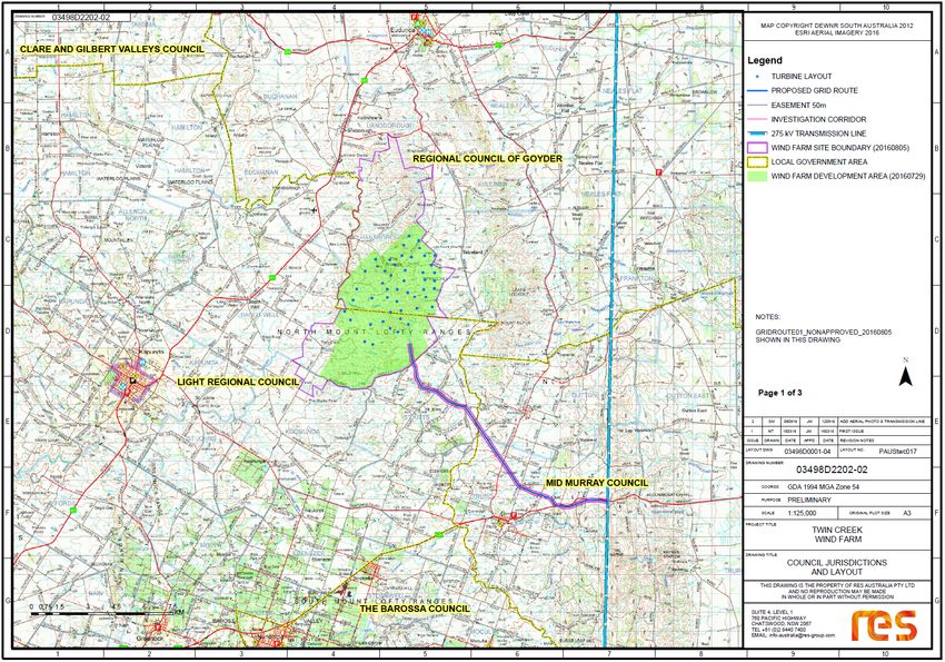
Location: 90km North East of Adelaide, 5km North East of Kapunda (Figure 1)
Area: 5600 hectares
Bushfire Protection Area: General and Excluded (Figure 2)
Local Government Areas: Mid Murray, Goyder and Light Regional Council Areas (Figure 3)
2.2 Vegetation
The northern Mt Lofty Ranges is predominantly characterised by Casuarina and Allocasuarina forests
and woodlands. Eucalyptus low open woodlands commonly dominate the higher rainfall areas and
give way to Allocasuarina species in the more arid parts. Approximately less than 10% of the
remnant vegetation remains.
The overall fuel hazards with these vegetation types can vary considerably and are expected to have
higher fuel loads in the areas of remnant vegetation.
The vegetation in the proposed area has been extensively cleared for agriculture purposes since
European settlement. The proposed site consists of predominantly native and introduced grasses
(Native Spear Grass, Austrostipa spp, Native Wallaby Grass Austrodanthonia spp, and Wild oats
*Avena barbata).
The overall fuel hazard for the Twin Creek Wind Farm site is expected to vary from Medium to Very
High/Extreme depending on seasonal conditions. Local landowners generally remove grazing stock
from the wind farm site during summer months because of limited feed and therefore a low overall
fuel hazard and reduced bushfire risk.
The neighbouring lower plains (off site further to the west) are predominantly cereal cropping lands
and depending on the season can have extreme near surface / elevated fuel loads and have
significant bushfire potential, especially during harvesting operations.
2.3 Terrain
The topography varies widely within the development area from hills and valleys with gently
undulating slopes in the west and tablelands to very steep slopes, ridges and inaccessible areas with
deep gorges. A series of generally longitudinal steep ranges with slightly undulating valleys in
between and numerous water courses are present.
142.4 Surrounding Land Use
Dry land farming is the predominant land use for the area comprising cropping and grazing (sheep
and cattle) enterprises. In areas where there is lower rainfall or unsuitable topography areas of
remnant vegetation exist.
A large area of the southern end of the proposed Wind Farm site is very barren and unable to
support livestock.
2.5 Environment
The Pygmy Bluetongue Lizard (Tiliqua adelaidensis) is listed as Endangered nationally under the EPBC
Act and Endangered in South Australia under Schedule 7 of the National Parks and Wildlife Act 1972.
The proposed development falls within the most southerly known population of the Pygmy
Bluetongue Lizard. The size of the development has been reduced to minimise the impact to this
species.
Threats to this species include change in land use, ripping, ploughing and pesticide use. The impact
of fire may depend on the timing, frequency and intensity of the fire. Fires in spring, late summer or
early autumn may have the most impact on this species. Fires in mid-summer, late autumn or early
spring may have little consequence (Recovery Plan 2012).
1516 Figure 1- Wind Farm location
17

Figure 2 – Bushfire Protection Areas relative to proposed turbine locations
18
Figure 3 - Local Government Area Boundaries
This document is formatted for double-sided printing; as such this page is left intentionally blank.

                                                                                                       19
2.6 Access and Egress
Access and egress throughout many parts of the proposed development area is restricted because
much of it is privately owned property. Public roads are limited and existing farm tracks are of
varying standards that may not meet GAFMWG standards for emergency response vehicles.
Construction of the wind farm will include engineered access roads (greater than the identified
GAFMWG standards) to each turbine location which will greatly improve fire crew access through
the site and difficult terrain areas.
2.7 Assets
The protection of human life is the highest priority and consequently areas that are settled are a
priority. Residential development is relatively low compared to other regions with Kapunda and
Eudunda the closest towns approximately 5 and 10km away respectively. The closest non-
stakeholder dwelling is over 2km away from any wind turbine generator.
The Murray Mallee BMAP primarily lists residential, infrastructure (e.g. power lines and substations)
and agricultural as key assets for protection.
The Flinders Mid North Yorke BMAP also identifies special fire protection assets such as schools,
childcare centres, aged care facilities, hospitals and health clinics as priorities along with identified
critical infrastructure and other economic assets.
2.8 Water Infrastructure
There is limited water infrastructure close to the proposed project area. Standpipes in nearby
Eudunda and Kapunda are the principal sources of water for fire fighting purposes.
There is a recommendation to increase available water via many large static water points onsite. The
number of tanks, their size and strategic location will be confirmed after consultation with the CFS
and pending Development application requirements.
2.9 Fire Weather
The development site experiences similar weather conditions to the Adelaide Hills, a Mediterranean
climate with cool wet winters and dry, warm to hot summers.
Summer months are dominated with wind patterns generally from the south-east; however, winds
from the north, with associated drier air mass and lower humidity, create the most significant fire
danger. Local winds can be variable and unpredictable at times including sea breezes and strong
gully influences.
2.9.1 Extreme Fire Weather Conditions
There is a dramatic increase in the likelihood and consequence of large fire events when the
following conditions are met:
o Very High to Extreme fuel hazard levels in vegetation
o low humidity
o decreased soil and fuel moisture, particularly in dry seasons
20o high temperatures
o high winds, changing direction during a fire
o steep slopes.
Fire Danger Indices (FDI) is used to determine fire danger and difficulty of suppression. FDI’s over 50
are considered Severe, and a total fire ban is declared. A fire burning on days of Severe to
Catastrophic Fire Danger Ratings (FDR) and any fire not contained within the first 5 to 10 minutes
will burn out of control and will stay burning out of control until there is significant moderation in
the weather (Koperberg, 2003).
Fire breaks have little effectiveness in conditions exceeding a FDI of 20 (High) nor are they generally
effective control measures in contiguous vegetation and rural landscapes. Fire breaks are most
effective immediately adjacent to assets. Provision of appropriate access tracks to enable crews to
access the fire when conditions have abated to put out the fire edge is more appropriate.
Rates of spread for grassfires in South Australia can be up to 30 km/hr (Cheney and Sullivan 2008) in
extreme conditions, such as those experienced during the Wangary Fire in 2005 and Pinery Fire in
2015.
Topography plays an important part in fire behaviour, Western and Northern aspects are generally
drier compared with Southern and Eastern aspects. Slope also influences fire behaviour and rate of
spread and is commonly known that for every increase of 10 degrees in slope, the rate of fire spread
doubles. Thus, for a 20 degree slope the rate of spread is four times that on flat land.
Thunderstorms can be expected any time of the year, and are more frequent late spring and
summer (October to January). Dry summer thunderstorms bring lightning during the Fire Danger
Season and these lightning strikes can cause serious fire problems due to multiple strikes and dry
fuel. This area experiences an average of 10 thunderstorm days per annum (BMAP). Lightning
conductors fixed on the top of turbines will reduce the risk of lightning hitting the ground.
2.10 Climate Change and Bushfires
South-Eastern Australia is documented to be one of the most bushfire-prone areas in the world.
Associated risks from climate change indicate that conditions will continue to worsen.
(DEWHA, 2009) Highlights that climate change will result in:
o Make the management of fire regimes to reduce risk to property, people and biodiversity
increasingly challenging
o Warming and drying over much of Australia, especially South-Eastern Australia
o An incidence increase of 5 to 65% in extreme fire danger days by 2020
o Affect fire regimes through its effects to temperature, rainfall, humidity and wind.
2.11 Fire History
There is no recorded fire history for the proposed site for the Twin Creek Wind Farm.
However, in recent times there have been some significant fires in the neighbouring areas, notably
Pinery 25th November 2015, Eden Valley 17th January 2014 and Angaston 16th December 2014 (refer
Figure 4).
212.11.1 Pinery Bushfire
The 2015 Pinery bushfire was a catastrophic bushfire that burned from 25 November to 2 December
2015, and primarily affected the Lower Mid North and west Barossa Valley regions. At least 86,000
hectares (210,000 acres) of scrub and farmland in the municipalities of Clare and Gilbert Valleys,
Light, Mallala & Wakefield were burnt during its duration.
The Pinery fire destroyed or rendered uninhabitable 91 houses, and destroyed 388 non-residential
structures, 93 pieces of farm machinery and 98 other vehicles. It also caused significant damage to
rural produce; 53,000 poultry and 17,500 head of livestock perished and up to AUS$40 million worth
of fodder and unharvested grains were destroyed.
Tragically the Pinery fire also claimed two lives, with a further 90 people hospitalized and 5 of the
victims suffering critical injuries.
2.11.2 Eden Valley Bushfire
The Eden Valley fire ignited just after midday on Friday 17 January burnt through almost 25,000
hectares and was declared as 'contained' by Monday 20 January.
Despite best efforts, unfortunately four houses were lost along with multiple sheds livestock, native
fauna and hundreds of kilometres of fences.
2.11.3 Angaston Bushfire
Two fires broke out in the Barossa Valley area. A grassfire that burnt through 700 hectares (1,730
acres) near Springton where a fire-fighter was injured while containing the blaze. The second fire,
near Angaston, ripped through 1,400 hectares (3,459 acres) in strong winds before being
extinguished.
22Proposed wind farm
Pinery Fire
Angaston Fire
Eden Valley Fire
23
Figure 4 – Fire history Map3 BUSHFIRE RISK
The following considers the assessment of risk from two different perspectives.
Firstly, is the wind farm likely to cause or increase risks of a bushfire (either during its construction or
operational phases)? Secondly, is the wind farm likely to limit any bushfire suppression operations?
The risks vary between the construction and operational phases and are separated accordingly.
3.1 Bushfire Risks During Construction
Existing land uses and human activity already pose some level of risk of generating a bushfire event
during the fire danger season; however the construction phase of the project has the potential to
increase bushfire risks primarily by increasing the level of activity in the region, specifically in relation
to:
o The use of heavy earthmoving machinery operating in rocky environment;
o Increasing the potential for vehicles to drive through dry grass;
o Increasing the volume of human activity and vehicle accessing the area;
o Storage and use of flammable fuels and materials;
o The use of grinders and welding equipment.
Increased activity on grassland vegetation during construction could potentially result in accidental
ignition. Depending on the conditions and the location of such an event, a bushfire may become
challenging to contain in the steep slopes and within areas of limited access, however, this will be
offset by the construction of new roads that will improve emergency vehicle access and increase
response times to reported incidents as well as serve as firebreaks.
The increased bushfire risk on the surrounding areas during construction and operation of the wind
farm is not considered to be more prevalent than any other development application or existing
general activity (e.g. farming, contracting or other construction).
In each case the potential of increased risk can be managed and mitigated provided appropriate
training, communication and management practices are put into place in accordance with the
recommendations identified in this bushfire management plan.
3.2 Bushfire Risks During Operation
The extent to which the proposed wind farm will increase overall bushfire risk will depend on the
design, suitable management practices, response procedures and effective communications
between stakeholders, particularly during the fire season.
The proposed wind farm development will introduce additional elements to the region that have, in
theory, the potential to increase bushfire risk. Many of these elements already exist or occur in the
region from other industries or operations including:
o Introducing infrastructure that can pose difficulties for suppression (e.g. Nacelle fires due to
height and OH&S considerations of falling debris and tower infrastructure affecting aerial
suppression);
o Increase to management and maintenance vehicles and crew working in area;
24o Increase in the number of turbines, substations and power lines in area (potential for
mechanical and electrical failures);
o Increasing the potential for lightning conductors;
o Electronics stored with combustible oils and lubricants.
The functioning wind turbines may experience electrical or mechanical failure causing ignition in the
nacelle and may lead to subsequent bushfires if not controlled. Whilst there is evidence to prove
that wind farms have caught fire from various factors the subsequent risk of these nacelle fires
causing uncontrollable bushfires is considered “less than that of many other activities expected in
these rural environments” (Australasian Fire and Emergency Service Authorities Council, 2014). It
should be noted that in comparison to other power generation e.g. coal or gas, wind energy has a
much lower ignition risk (see Hazelwood Mine Fire Inquiry).
The types of fire risks related to wind energy facilities may include:
o Nacelle (including turbine oil) fires;
o Electrical faults during construction or from connection lines;
o Fire fighting limitations within and adjoining the wind farm footprint, such as possible
limitations on aerial support, and access and egress conditions (see 3.3 below);
o Access to water sources within or adjoining the facility;
o Operation of winches and machinery during monitoring and maintenance tasks;
o Possible impacts from downwind air turbulence on fire behaviour (see 3.31 below)
o Impacts of lightning.
Suppression of fire in the nacelle by ground crew is impossible; the initial detection of problems that
may lead to fire in the nacelle and subsequent fires on the ground is the key to minimising asset and
infrastructure loss and ignition of bushfires. Detection and automatic fire protection systems would
reduce the risks, increase the ability to contain potential problems and decrease response times to
reported incidents.
With the site proposed to be developed on lands with naturally low fuels and construction of roads
to turbines increasing access for emergency vehicles through the area the overall potential for
operational activities to increase the bushfire risk and impact on the surrounding areas is low, if the
recommendations within this plan are implemented.
3.3 Potential Impacts on Bushfire Suppression Operations
The following includes an assessment into the potential impact of the proposed development on the
conduct of bushfire suppression operations undertaken in the region.
Fire-fighter safety and the protection of life are paramount during all suppression operations.
Priority suppression activities will focus on Protecting Life, Property and Environmental Assets.
The operating wind farm could potentially impact bushfire suppression operations by:
o Possible interference with radio transmissions (radio frequency);
o Increasing the total number of assets to be protected in the area;
o Increasing safety risks with nacelle fires and falling debris;
25o Affecting aircraft operations (access, efficiency and turbulence);
o Increasing elevated structures as risk factors (vertical and horizontal).
The NSW Rural Fire Service submission to the Select Committee on Wind Turbines (March 2015)
noted that wind turbines will not prevent the NSW RFS from fighting a fire and suppression
strategies will consider a variety of factors including aviation hazards. This is effectively the same in
South Australia as turbines pose no more of an obstacle than any other feature in the landscape.
The level of cooperation, support and understanding between key stakeholders including
landowners, CFS and the local community is critical to successful fire suppression.
All CFS actions are in accordance with Fire and Emergency Services Act 2005 and CFS policy and
procedures (Operations Tri-Manual). Local CFS Brigades will most likely form the initial response to
fire incidents. It should be noted that private farm fire units are likely to respond and aid also and
must be operating as per the guidelines.
Local CFS brigades will be provided with information and become familiar with the new access tracks
(especially in higher risk areas), water sources and wind farm infrastructure to assist them with
determining initial suppression strategies.
The additional OH&S concerns of falling debris must be individually risk assessed. It is unlikely CFS
crews will consider suppression activities with fires in a nacelle (at the top of the turbine tower) due
to height and falling debris factors, but instead are likely to patrol from a safe distance at the tower
base. Previous turbine fires in Australia have had responding crews establish an exclusion zone of
between 50-200m to ensure the safety of crews from falling debris.
The first crews responding to a fire need to undertake dynamic risk assessments to ensure fire-
fighter safety and appropriate suppression strategies are in line with any response plans. If direct fire
suppression is inappropriate alternative actions including parallel or indirect strategies may be
implemented.
Initial response strategies should consider using existing access tracks to gain access to the bushfire.
The new service tracks will also provide increased opportunity to utilise low fuel areas between
tracks to undertake indirect attack methods of fire suppression to contain fast moving bushfires that
direct attack options may not be appropriate or safe.
Current access and egress to most of the area of the proposed development area is difficult due to
the topography and terrain. Post construction the increased number of service tracks to the turbines
and substations will improve bushfire suppression operations by increasing vehicle access,
emergency assembly points, strategic observation points and safe zones to emergency crews.
3.3.1 Aerial Suppression Considerations
Twin Creek Wind Farm is in the CFS Secondary Response Zone (refer CFS Operations Tri Manual SOP
11.1 Aerial Fire Fighting). This means that bushfire suppression activities may be able to be
supported by aerial suppression (rotary and fixed wing) based on a specific request by an Incident
Controller and approved at a state level.
26There are factors that potentially limit the effectives of aircraft use in Aerial Fire fighting, including
reduced visibility (fog, dust, smoke), vertical and horizontal obstructions (trees, power lines, towers,
masts and turbines), strong winds and more recently Remotely Piloted Aircrafts (refer CFS Aerial Fire
fighting Limitations).
There is no guarantee that aircraft for either suppression or an observation platform will be available
for immediate dispatch, particularly in the Secondary Response Zone. This will be determined at the
time by the CFS State Air Resource Coordinator (SARC) in consultation with the CFS Regional Office
and Incident Management.
Aircraft operations are undertaken under Visual Flight Rules which limits operational use to daylight
hours and only with clear visibility of the ground and obstacles in the landscape that may put them
at risk.
Pilots, air attack supervisors and air operation managers constantly undertake dynamic risk
assessments to review and consider options and determine appropriate strategies to safely
undertake suppression operations. In this context, aerial fire fighting will treat turbine towers the
same as any other obstacle.
The Australasian Fire and Emergency Services Council (AFAC) position paper on Wind Farms and
Bushfire Operations concluded …” that wind turbines are not expected to pose increased risks due to
wind turbulence or the moving blades. Local wind speeds and direction are already highly variable
across landscapes affected by turbulence from ridge lines, tall trees and buildings.”
Aerial suppression using fixed and rotary wing machines are a valuable and efficient asset that can
also provide additional safety coverage to ground crews, however they must be supported by crews
on the ground mopping up to ensure the fire is adequately contained.
The CFS fact sheet understanding Aerial Fire fighting highlights that “…community perception is that
aircraft alone put out bushfires, this is not true” and the CFS website Aerial fire fighting defines aerial
fire fighting as “the use of aircraft and other aerial resources to assist fire-fighters on the ground in
achieving bushfire suppression objectives”. It is important to note, that firefighting aircraft
(regardless of their size or type) do not extinguish a bushfire alone, but are deployed to provide an
important support function to ground firefighting resources.
274 READINESS
4.1 Equipment
All staff and contractors on site should have the appropriate personal protective equipment (PPE)
that meet Australian standards (where they exist) or at least comply with Fire and Emergency
Services Act and AFAC guidelines, during the fire danger season.
All fire fighting equipment, pumps and sprinklers need to be checked prior to the fire danger season.
A vehicle equipped with a dedicated fire fighting unit on site, or at the very least, all vehicles carrying
water and a rake hoe for initial fire suppression during the fire danger season, will assist in the rapid
suppression of a small fire should it start on site.
Automated sprinklers and fire detection systems are also very effective in rapid detection and
suppression once the site is operational.
All vehicles should carry a mobile phone or UHF radio to enable rapid reporting of a fire outbreak.
4.2 Training
Staff involved directly or indirectly in fire incidents should have a minimum of training and attend
the Basic Fire Fighting 1 course delivered by the CFS.
Annual pre-season refresher training, including a burn over scenario, is recommended. Staff may
also benefit from a bushfire awareness program.
Each staff member should be encouraged to prepare a written bushfire survival plan. A survival plan
should also be prepared for the site, listing actions to take and identify Bushfire Safer Places and Last
Resort Refuges should a bushfire threaten the site.
4.3 Safe Work Procedures, Policies and Guidelines
Vegetation management, firebreak and fire access track maintenance, checking of equipment,
review of response plans, updating communication and contact details and training needs to be
completed before the commencement of the fire season.
Ensure all staff, contractors and site visitors are informed of the fire response plan, and follow
identified legislative requirements, policies and procedures, particularly in the use of grinders,
welders and similar equipment that pose a potential bushfire risk during the fire danger season and
on total fire ban days. Ensure that all works during the fire danger season have appropriate permits
from Local Government, (Goyder, Light Regional and Mid Murray Councils).
During the fire danger season, vehicles should keep to the tracks whenever possible and restrict low
clearance vehicles with catalytic converters from entering the site on high fire danger days.
Smoking should be restricted to prescribed areas that have had vegetation removed.
Have appropriate “initial” suppression equipment available on site i.e. carry fire extinguishers or fire
fighting equipment in vehicles.
28You can also read