UPDATED 2022 - West Whiteland Township, PA
←
→
Page content transcription
If your browser does not render page correctly, please read the page content below
UPDATED 2022
A HISTORY OF WEST WHITELAND

                         by

  Martha Leigh Wolf Brandywine Conservancy

                        and

            Diane Sekura Snyder
     West Whiteland Historical Commission

       Compiled, Edited and Published by
             Diane Sekura Snyder

     Written and Published under the Auspices of
  THE WEST WHITELAND HISTORICAL COMMISSION

                       Exton
West Whiteland Township Chester County, Pennsylvania
                        1982
      Revised by Commonwealth Heritage Group
                        2022
CONTENTS
TO THE READER ........................................................................................................... 4

INTRODUCTION ........................................................................................................... 6

EARLY SETTLEMENT: PLOTS AND PLANS ................................................................... 7
         THE WELSH TRACT ............................................................................................ 7
         KATAMOONCHINK.............................................................................................. 9
         THE ENGLISH .................................................................................................... 9
         THE GERMANS................................................................................................. 10

WHITELAND ROOTS ................................................................................................... 11
         THE THOMAS FAMILY....................................................................................... 11
         THE ZOOK FAMILY ........................................................................................... 16
         THE JACOBS FAMILY ........................................................................................ 17

DOING THEIR BIT FOR FREEDOM ................................................................................ 19
         THE BATTLE OF THE CLOUDS ........................................................................... 19
         THE PLUNDERING ............................................................................................ 20

TRAVEL BY ROAD ....................................................................................................... 22
         EARLY ROADS ................................................................................................. 22
         THE LANCASTER TURNPIKE .............................................................................. 23

TRAVEL BY RAIL ......................................................................................................... 27
         WEST CHESTER RAILROAD............................................................................... 27
         PENNSYLVANIA RAILROAD ............................................................................... 29
         CHESTER VALLEY RAILROAD ............................................................................ 33
         TRENTON CUTOFF ........................................................................................... 34

THE BOUNTEOUS GREAT VALLEY: FARMS .................................................................... 35
         THE LARGE AND THE SMALL............................................................................. 35
         AGRICULTURAL INNOVATIONS ......................................................................... 37

PUBLIC HOUSES AND STORE HOUSES ...................................................................... 40
         TAVERNS AND INNS ......................................................................................... 40
         GENERAL STORES ............................................................................................ 46

THE BOUNTEOUS GREAT VALLEY: INDUSTRY ............................................................... 48
         MARBLE QUARRIES .......................................................................................... 48
         LIMESTONE QUARRIES..................................................................................... 50
         MINES............................................................................................................. 51
         MILLS ............................................................................................................. 52
COTTAGE INDUSTRIES ..................................................................................... 54

FRIENDS AND WORSHIPERS ....................................................................................... 57
          THE QUAKERS ................................................................................................. 57
          ST. PAUL’S EPISCOPAL CHURCH ....................................................................... 57
          GROVE UNITED METHODIST CHURCH ............................................................... 58
          ST. MARY OF THE IMMACULATE CONCEPTION................................................... 60

LEARNING: A SOUND MIND ......................................................................................... 61
          SUBSCRIPTION SCHOOLS ................................................................................. 61
          PUBLIC SCHOOLS ............................................................................................ 62
          CONSOLIDATED SCHOOLS ............................................................................... 64
          CHURCH FARM SCHOOL ................................................................................... 65
          DEVEREUX FOUNDATION ................................................................................. 67
          RYERSS INFIRMARY ......................................................................................... 68

RECREATION:...IN A SOUND BODY .............................................................................. 69
          THE WHITELANDS HUNT .................................................................................. 69
          SUNDRY DIVERSIONS ...................................................................................... 70
          COUNTRY CLUBS ............................................................................................. 71

EPILOGUE .................................................................................................................. 72

ACKNOWLEDGEMENT ................................................................................................. 73

APPENDIX .................................................................................................................. 76
TO THE READER

        In 1982, Chester County's Tricentennial year of 1982 has provided an incentive for
the West Whiteland Historical Commission to share with others what we know about the
history of the Township. Recent developmental pressures in West Whiteland have
threatened a number of our historic buildings. In an effort to preserve as many of our
remaining historic properties as possible, we decided to locate and evaluate all of the historic
resources in the Township as part of the Chester County Historic Sites Survey. Additional
protection was sought for our most historically valuable properties by nominating them to
the National Register of Historic Places. This book enables us to share with the public a
vast amount of information which we have generated as the result of this work. The
emphasis in this book is on life and events in West Whiteland as they were prior to 1930.

         The Chester County Historic Sites Survey has been conducted as part of a national
program to identify all historic resources in the United States which are at least 50
years old. Two hundred such locations were discovered and recorded in West Whiteland
during the survey (1979-1981). From these, we selected the properties of most probable
significance for further investigation and documentation, with the intent of submitting
those most worthy to the National Register in one, comprehensive Multiple Resource
Nomination. Sources of research material included the Chester County Court House
(wills, inventories, title searches, road dockets), the Chester County Historical Society's
extensive collections, the Historical Society of Pennsylvania, the Atheneum, the
Hagley Library, the Philadelphia Free Library, the State Archives in Harrisburg, the
National Archives in Washington, D.C. and the Commission's own files, including taped
oral history interviews with long-time residents. After evaluating available information
and visiting each site, we determined the Township's most historically significant
properties. The Multiple Resource Nomination, containing 58 properties and one
district, was submitted in its initial form to the Pennsylvania Historical and Museum
Commission in January 1982.

        The format of this book is designed to give you ready access to the information
that may most interest you. A brief summary of what is presently known about each
of the Township's historic resources is contained in the Appendix. The 3-digit numbers
in parentheses throughout the book are keyed to the Appendix and the Historic Sites
Map. While reading, you may want to pinpoint the location of each property by
referring to the Appendix and Map. They will also enable you to take a do-it-yourself
historic tour of the Township. Perhaps this book will provide information on a building
which has always intrigued you or unearth for you the surprising significance
underlying a seemingly conventional exterior.

       One of the West Whiteland Historical Commission's goals is to increase awareness
among Township residents of the rich historic heritage which still surrounds us. Each property
can best be appreciated when described in the perspective of its own time and the
contribution it has made to West Whiteland's development. The information in this book
represents our interpretation of a considerable amount of material.

                                                                                              4
We hope you will be encouraged to explore West Whiteland's history further. There
still is much to be learned. Additional information is available at the offices of the West
Whiteland Historical Commission; you are most welcome to use our library and collections.

Diane S. Snyder Chairman

                                      2022 SURVEY UPDATE

        Beginning in 2019, West Whiteland Township commenced a comprehensive update to
the original 1979-1981 Chester County Historic Sites Survey. The project was supported by
West Whiteland Township and a grant provided by Chester County’s Vision Partnership
Program. Since 1982, the West Whiteland Historical Commission has used the valuable
information contained in this book and the companion Historic Resources Map to assess
proposed changes affecting historic resources, thereby safeguarding the Township’s history
for future generations. The 2019 survey update was completed in the beginning of 2022 and
represented the first comprehensive update to the original 1982 survey.

        Commonwealth Heritage Group, Inc. (Commonwealth), under the direction of the
West Whiteland Historical Commission, revisited every historic resource listed on the
Township’s Historic Resources Map, and produced updated photographs and survey forms for
each property where possible. Additionally, survey data was recorded and organized into in a
geodatabase allowing future updates to survey information to be seamlessly integrated into
the data structure thereby eliminating static paper forms. The survey update also revealed
and recorded over 400 historic buildings, structures, and archaeological sites related to the
vibrant history and development of West Whiteland. The survey was further updated by
inventorying select buildings constructed between 1930-1972, which were not 50-years old
at the time of the initial 1982 survey, but since that time have continued to describe the
development patterns and history of the Township. The updated survey information has been
integrated into this book honoring its original format.

Zook House (305). Former headquarter of the West Whiteland Historical Commission (Fletcher MacNeill, 1975).

                                                                                                         5
INTRODUCTION
        West Whiteland Township occupies 8,250 acres of land in central Chester County,
Pennsylvania and lies approximately 25 miles west of Philadelphia, historically the
region's port of entry and major market center. Originally part of Whiteland, a township
established in 1704, it divided, East and West, in 1765. West Whiteland's perimeter is
rectangular, with its northern and western boundaries following lines surveyed in 1687
for the Welsh Tract. Despite attempts in the 1870's to alter the boundary between East
Caln and West Whiteland for the convenience of certain landowners, the citizenry
petitioned successfully against any changes which would "disfigure and mar the
symmetry of the lines of West Whiteland." In the 18th century, West Whiteland's four-
mile breadth was calibrated in milestones along the Lancaster Turnpike. Today, the
Township's eastern and western boundary lines are readily discernible by Route 30's
intersections with Route 202 and the Downingtown Bypass, respectively. The northern
and southern limits are suggested by the North Valley Hills (Whitford Hills) and South
Valley Hills.

       The Chester Valley or, as it is known interchangeably, Great Valley, cuts through
the center of the Township and extends north and west for approximately 25 miles. Major
transportation routes, primarily Route 30 and the Pennsylvania Railroad, follow this valley
to a succession of Chester County towns, among them Downingtown, Coatesville,
Parkesburg, and Atglen.

       Historically, the Great Valley formed the heart of "one of the greatest
agricultural districts in the country." The West Whiteland segment of the Valley is
particularly wide and level, and thus well- suited for farming; as a consequence,
agriculture dominated the Township's economy until the 1950's. While the Valley floor
was ideal for house and farm, timber from the North and South Valley Hills warmed
the hearth and fueled local industry.

       With its broad band of limestone pocketed by veins of white, blue and black
marble and iron ore, the Great Valley's riches have not been reserved solely for
farming. Quarries and mines have been worked in the Township since the time of
settlement. And the Valley is still cherished for its water resources, which in the mid-
19th century were described as "fountains of cold and pure water so numerous that
almost every farm ha(d) its springhouse near the door." Lying within the Brandywine
watershed, West Whiteland is drained primarily by Valley Creek and its tributaries.
One of these, Broad Run, flows through the Township's southwest corner and
converges with Valley Creek in East Bradford, Until the late 19th century, all of the
Township's mills were water-powered.

       As this narrative will reveal, the historical development of West Whiteland has
been influenced strongly by its position within this Great Valley of natural and locational
advantages.

                                                                                         6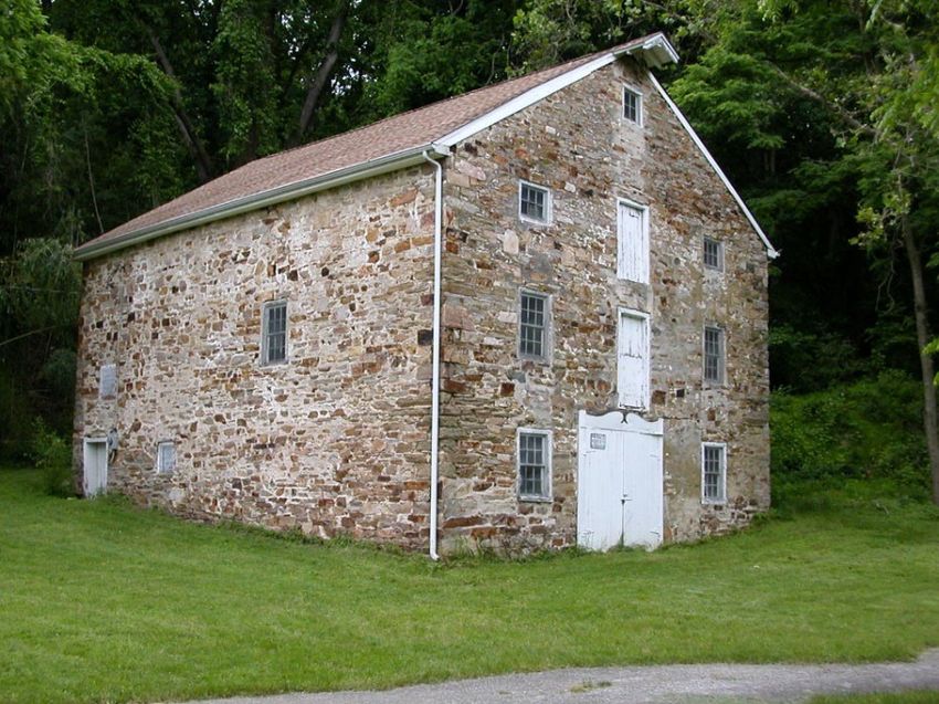
EARLY SETTLEMENT: PLOTS AND PLANS

                                  THE WELSH TRACT

       The 1711 settlement of Whiteland was the result of plans laid in England nearly 30
years earlier by William Penn and a group of Welsh Quakers. While the general history of
Pennsylvania's founding needs little elaboration here, the intriguing story behind Penn and
the "Welsh Tract" merits retelling for its impact on West Whiteland.

       In 1682, William Penn found himself in London, meeting with certain Welsh
landed gentry to discuss the sale of some land. These gentlemen, like Penn, were
converts to Quakerism. At that time, Quakers were unpopular in England, and were
subject to persecution and imprisonment for their beliefs. Penn, born in 1644, recently
had received a charter for 50,000 square miles of land in the New World from King
Charles II as repayment for a debt owed to William's late father, Admiral Penn. By virtue
of that charter, Penn became the sole proprietor of what would become Pennsylvania,
with full rights to govern as he saw fit. He began organizing an emigration of his fellow
Quakers to America where they could, in his "holy experiment," enjoy religious freedom
and self- government.

       Penn's negotiations with the Quakers from Wales bore little resemblance to his
dealings with those from England. According to Browning in Welsh Settlement of
Pennsylvania, English Quakers were mostly the "plain people, small lease holders,
yeomanry, farmers, tradesmen and shop keepers." Consequently, few of their
purchases were for more than several hundred acres. On the other hand, the Welsh
Friends as members of the upper classes, had more grandiose visions of their future in
America. It is thus understandable that, in London in 1682, these members of the
"highest social caste of the landed gentry" would meet privately with Penn to negotiate
the purchase of one large tract of land solely for settlement by the Welsh. Before leaving
Wales for their new land in America, the Welsh were convinced that William Penn had
given them his "solumn word" that they would "not be obliged to answer nor serve in any
court whatsoever but should have courts and magistrates of their own."

As a result of these negotiations, Penn issued a warrant in 1684 to his Surveyor-General,
Thomas Holme, with instructions that "about 40,000 acres, may be layd out contiguously
as one Barony" for the Welsh Friends. This "Barony" became known as the Welsh Tract.
In adherence to Penn's general policy of settlement, David Powell, Holme's deputy,
surveyed township units of 5,000 acres within the Tract. Although the western boundary
of the Welsh Tract was not clearly defined, a 1687 survey draft showed Whiteland to
be the westernmost township. Despite several attempts to alter it in the 1860's and
1870's, West White-land's western boundary line remains true to that 1687 survey. The
Welsh Tract, even in 1687, included the Townships of Haverford, Radnor, Merion,
Tredyffrin, Willistown, Easttown, Goshen, and part of Westtown, along with Whiteland,
and it far exceeded the 40,000 acres originally agreed upon.

                                                                                         7
Map showing the approximate location of the Welsh Tract in Chester County c. 1682-1684.

        The boundary line between Philadelphia and Chester counties ran through the
Welsh Tract. This resulted in the Welsh being called upon to pay taxes and serve as jurors
and constables by both counties. The Welsh resisted this separation but, as they could
not present written evidence of Penn's "solumn word," the courts upheld the boundary
line between the two counties. This decision, along with repeated intrusions into the
integrity of their Tract by other national groups (primarily the English), caused the Welsh
to abandon their idea of an autonomous barony by 1686.

        Despite these initial setbacks, West Whiteland's first settler was a Welsh Quaker.
Richard ap Thomas of Whitford Garne, Flintshire, Wales, had purchased 5,000 acres of
unlocated land from William Penn while in England. Accompanied by his young son,
Richard, Thomas traveled in 1683 with Penn to America, where he died shortly thereafter.
Upon reaching legal age, Richard Thomas (I) set about to claim his father's legacy. By this
time, most of the more desirable land in or near Philadelphia had been claimed, thereby
forcing young Thomas to accept land further west. In 1704, he received a patent for 1869
acres in the "gloomy dale," the name given to the Great Valley in Whiteland.

                                                                                                  8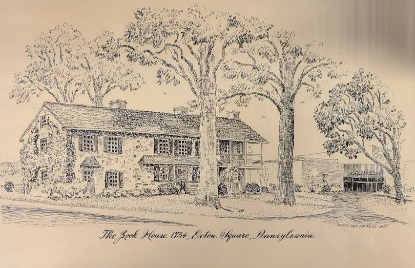
KATAMOONCHINK
In the early 18th century, the Lenni-Lenape Tribe continued to inhabit Whiteland.
To date, only a few of the villages established by this peaceful, agrarian people have been
identified in Chester County, among them Queonemysing along the Brandywine and
Minguhanan on the White Clay Creek. According to Richard Thomas (III)'s account of his
ancestors in West Whiteland, there also was a Lenni-Lenape settlement along the Valley
Creek, in the vicinity of present-day Exton. Its name, Katamoonchink, meant "hazelnut
grove." It was near here, in what was then a veritable forest, that Richard Thomas (I)
settled about 1711, purportedly to share in the protection from the "wild beasts" provided
by the barking dogs of the Native American village.
Within a year, Thomas took as his bride Grace Atherton from Liverpool, England.
Their wedding, held at the Thomas homestead, was witnessed by a number of individuals
who, it appears, were living in the Township. Among those attending were: Richard
Anderson, Adam and Elizabeth Baker, John Earle, David Howell, Thomas James, Evan
Lewis, David Meredith, Llewellin Parry (married to Richard Thomas's sister), John and
Catharine Spruce, and Lewis Williams. As this was a Quaker ceremony, it may be assumed
that most of those present were members in good standing of the society of Friends. During
the succeeding decade many of these Quakers purchased land from Richard Thomas in
the northern half of the Township. The 1715 Whiteland Tax List shows 17 heads of
household living in what today is West Whiteland; at least 10 of these taxpayers were
Welsh. Statistics from The Best Poorman's Country show that, while the Welsh population
in Chester County peaked at 17% in 1730, it stood at over 50% in Whiteland at that time.
As the new settlers in the Township became increasingly numerous, their relationship
with the Native Americans continued, by and large, to be amicable. There were some
problems, however, even for Richard Thomas. A letter from George Aston to Governor
Gordon in 1727 verifies a claim filed by Richard Thomas against a Native American leader
referred to as "King of Five Nations of Indians." Thomas alleged that, upon returning
through Whiteland from a treaty meeting with the Governor in Philadelphia, the "King"
helped himself to one of Thomas's cows valued at four pounds. As was the custom, Thomas
brought two of his neighbors (one of whom was his father-in-law) to testify before George
Aston as to the value of the cow.
THE ENGLISH
Settlement continued in the Township and expanded beyond the Welsh. The
presence of Grace Atherton Thomas in Whiteland inspired purchases by her father, Henry,
and her two brothers, Thomas and William. Some other early residents of English extraction
were John Holland and David Worthington. Holland apparently was a friend of the Atherton
family and instrumental in bringing Grace's sister, Mary, from England around 1714.
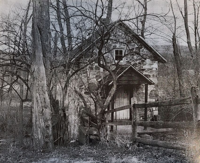
9Woodcutter's Cottage (100.02). Located near the site of the first settlement in West Whiteland, has a 1707
datestone.
After William Penn's death in 1718, a second wave of patents was issued by his
sons, John, Thomas and Richard, in the 1730's. These were for land located in the
southeastern portion of West Whiteland. The patent holders, most of whom were English,
included: John Holland (1734); Richard Anderson, George Garret, and Thomas Atherton
(1735); David Meredith (1736); William Lewis (1738); Henry Atherton, John Morgan, and
John Jerman (1739); John Ingram and John Collins (1741); and Mathias Lamey (1743).
THE GERMANS
In 1779, by an Act of Pennsylvania's Assembly, the estates of Penn's three sons
became vested in the Commonwealth of Pennsylvania. Yet a third group of patents was
issued in the 1780's, mostly for the still vacant land in the less desirable hilly, scrubby
Barrens in the southwest part of the Township. A small number of German families settled
this land, apparently representing the southernmost penetration of this nationality into the
County. Two families in particular, the Boyers and the Hoffmans, controlled several hundred
acres in the Barrens through purchase and intermarriage.
In the midst of these developments, the influence of the Township's founding family
remained strong. Through family ties and further acquisitions, the Thomas's occupied or
controlled most of the Township's prime valley land by the end of the 18th century, a
position they were to maintain for the next 200 years.
10WHITELAND ROOTS
THE THOMAS FAMILY
The marriage of Richard and Grace Thomas in 1712 marked not only the initial
settlement of West Whiteland but, just as importantly, the dawning of a local dynasty.
Thomas and his descendants, through their success in marriage, agriculture, and industry,
easily dominated the Township for the next two centuries. Fortunately, this was a family
of strong intellect and civic purpose, with many members contributing notably to their
community.
While little is known of Richard and Grace Thomas' first house, a "permanent"
homestead was erected c.1749. Of stone construction, two stories high, and
distinguished by its distinctive gambrel roof, the homestead stood until 1895. A small
stone building (100.02), banked into a slope near the Valley Creek and known locally
as the "Woodcutter's Cottage," is all that remains from the so-called mansion tract. The
homestead was acquired in 1843 by a grandson, Richard Ashbridge, who "…erected
thereon a capacious colonial mansion…on exactly the same plans as the old farmhouse
which stood for a long time on this property, the new house being, however, much
larger." This house is referred to as the “Richard Ashbridge House” (100.01).
Richard and Grace's only son, Richard (II) (1713-1754), is credited with
construction of the Thomas Mill (107) in 1744. He married Phebe Ashbridge in 1739,
and she bore him two extraordinary sons, Richard (III) and George, as well as three
daughters.
Following Richard's death in 1754, Phebe remarried, this time to William Trimble of
Concord Township. Her three daughters by Richard Thomas each married a son of
Trimble; one of these, William, established the Trimble Mill (214) c. 1790.
West Whiteland had no citizen more remarkable than Richard Thomas (1744-1832).
Although born a Quaker, he took up arms as a Colonel of the First Regiment of Chester
County Volunteers, thereby earning the epithet, 'the Fighting Quaker." Following seven
years of active military service, Richard returned to his West Whiteland farm, which
had been managed in the interim by his brother, George, and initiated an ambitious
building program. Whitford Lodge (204), a two-story brick manor house, went up
c.1782. It was followed by Whitford Hall c.1796 (202) and Ivy Cottage c.1800, (205).
By 1798, Richard (III)'s holdings included five houses, several barns, the 1744
Thomas mill, cooper, smith, and "taylor's" shops, and several related structures. In
addition to his role as gentleman farmer, Richard served in the Pennsylvania Assembly
(1786-1798), the Pennsylvania Senate (1790), and the 4th, 5th, and 6th Congresses of
the United States. Despite these important duties (and the traveling they entailed,
which, in the winter of 1800, had taken him to Washington, DC), Richard maintained a
strong affection for his West Whiteland home.
11As a Congressman in Washington, D.C. in 1800, he was seized by an apparent
attack of "homesickness." In a letter to his nieces which compared the city to "our
Valley," Thomas implored them to "…write and give me accounts of occurrences or any
little cheerful anecdotes, or sentiments, or any free thoughts as they rise."
Colonel Richard Thomas III (1744-1832).
Whitford Lodge (204). Built c. 1782 Richard Thomas (III) (Commonwealth 2021).
With his wife Thomazine (Downing), Col. Richard resided at Whitford Lodge. He was
a Manager of the Philadelphia and Lancaster Turnpike Company for 39 years.
12While the career of Col. Richard's brother, George (1746-1793), centered
entirely on his Oaklands farm (207), his innovations in agriculture earned him a high
degree of respect in his own right. In addition to managing one of the largest farms in
the Great Valley, George Thomas pioneered in the introduction of lime as a soil
supplement in 1787. Unlike his brother, who joined with the Episcopal Church at the
War’s end, George continued within the Society of Friends, remaining a pillar in the
Township's Quaker community.
Two independent Thomas lines descended from Col. Richard and from George.
Richard's progeny evidently inherited his talent for business and industry. One branch
settled in Centre County and engaged in the iron industry. For several generations
following Richard, the family remained on the original patent in West Whiteland,
keeping the Thomas Mill (107) open until 1935. The Miller's House (107.01) and Mill
(107.02) were owned by Thomas family descendant John Hagee and his wife, Fran
through the 1980s.
George Thomas' line pursued agriculture and horticulture while continuing the
family's active participation in civic affairs. A grandson, George, M.D. (1808-1887),
through his meticulous management of Oaklands Farm, earned the title "Prince of the
Great Valley." Despite obtaining a medical degree, he never practiced medicine,
preferring horticulture and farming instead. (Family legend has it that George hated
the sight of blood.) He also served as a director of the National Bank of Chester County.
The sons of George, M.D., George, Jr., Charles, and J. Preston, oversaw large farms in
West Whiteland. George, Jr. remained at Oaklands (207) where a branch of his descendants,
the Mcllvaines, resided through the 1980s. Charles (1847-1948) inherited Fairview (210)
and, in addition to his long service as a Township Supervisor, took a keen interest in
horticulture. His granddaughter, Barbara Burdick, a charter member of the West
Whiteland Historical Commission and local authority on the Thomas genealogy, resided
at the former Whitford School in the 1980s (209).
13Selected genealogy of the Thomas Family.
J. Preston Thomas (1842-1905) farmed at Whitford and demonstrated a deep
commitment to public service. He was named Director of the Poor of Chester County in
1887. Among numerous other appointments were board positions with Dime Savings Bank,
Preston Retreat (in Philadelphia), the Epileptic Colony at Oakbourne, the Chester County
Hospital (of which he was a founder), and the National Bank of Chester County. (He was
named its President in 1901). He was also one of the founders of the Oaklands Creamery
Association who opened the Oaklands Creamery (111) in 1881.
14Lindenwood, home of J. Preston Thomas, formerly located on the north-west corner of Whitford and Route 30.
Seated on porch are J. Preston and Hannah Thomas. Standing are (left to right) Martha Gibbons, Anna Mary and
George III. Photograph taken c. 1885. House was demolished c. 1970.
J. Preston's son, George III (1871—1937), built Whitford Garne (155) in 1905.
Employed by Lukens Steel of Coatesville, to which he commuted daily, George III was
the first of his immediate family to find non-farming employment outside the
Township. The family's agricultural bent did not die with J. Preston, however, for his
daughter, Martha Gibbons Thomas (1869-1942),known by the family as "Pattie,” took an
early interest in those pursuits. At the age of 8, she was described by her mother as "full
of her Banties now, a regular little farmer as ever was...(who) tries to teach her brother
some time but teacher and scholar soon give out." Martha grew up to be a member of
Bryn Mawr College's first graduating class and was very active in the Women's Suffrage
movement. She also was the first woman from Chester County to be elected to the
Pennsylvania House of Representatives in 1922. Martha maintained a life-long interest in
farming, becoming a breeder and authority on Guernsey cattle. J. Preston Thomas's line
continued to be represented in West Whiteland through the 1980s by his granddaughter Ann
(Howell) Chandler who resided at Ivy Cottage (205).
15Ivy Cottage (205) constructed c. 1800 by Colonel Richard Thomas (III) (Commonwealth 2021).
No accounting of the Thomas family would be complete without mention of Rev.
William L. Bull (d.1932), a descendant of both Col. Richard and George Thomas. From
his mother, Sarah Thomas Bull, he inherited both Ivy Cottage and a philanthropic spirit.
Although an Episcopalian, Bull did not confine his energies solely to missionary work
within his own church. He donated generously to St. Mary's Chapel (032), and Church
Farm School (025). A champion of the working class, Rev. Bull purchased Whitford
Lodge (204) in 1901 from a collateral branch of the family and donated it to the
Pennsylvania Association of Women Workers as a vacation retreat for its members
retreat for its members.
THE ZOOK FAMILY
Another family of long residency in West Whiteland was the Zooks. Moritz Zug
(Zook), grandson of a Swiss Anabaptist preacher, moved to the Township from Berks
County in 1770. He purchased a house built by William Owen in 1750; eight generations of
Zooks subsequently resided there. The Zook House/Owen House (305) served as a haven
for Amish and Mennonites migrating west from Philadelphia to Lancaster County and
Ohio. It also played a more recent role which Moritz Zug certainly never envisioned--as
catalyst for the founding of the West Whiteland Historical Commission. In 1971-1972,
during its development of the Exton Square Mall on the Zook property, the Rouse
Company, in consultation with the newly formed Historical Commission under Mildred
Willenbrock, agreed to preserve and fund the restoration of this local landmark.
Appropriately, the West Whiteland Historical Commission used the Zook House as its
headquarters for a time.
16Zook House/Owen House (305). Home to eight generations of the Zook family.
THE JACOBS FAMILY
For nearly 200 years, members of "an ancient and distinguished family," the
Jacobs', resided in West Whiteland. John Jacobs (1722-1780) was the first of his family,
who were Quakers living in Perkiomen, to settle in the Township. He purchased several
contiguous tracts in the northeast portion of West Whiteland c. 1752 and commenced
farming. Although an exemplary citizen under British rule (he was a member of the General
Assembly from 1762-1776), Jacobs became a "violent Whig" at the outbreak of the
Revolutionary War. He was a member of the Constitutional Convention of July 15,
1776 and is reputed to have entertained Gen. Washington at his Solitude Farm (329).
Jacobs died in 1780 while "giving…Washington the benefit of his services in keeping the
patriot army supplied with provisions-and clothing and was getting together horses and
fodder from among the Quakers of Chester County, who were 'doing their bit'."
Benjamin Jacobs House/Strawbridge Farm (324).
17John's son, Benjamin (1731-1806) was expelled from the Uwchlan Meeting in 1777
for signing paper currency to finance the War effort. He also assisted his father in gathering
supplies for Washington's army encamped at nearby Valley Forge. Benjamin attained great
prominence as a surveyor, lawyer, judge (Court of Common Pleas, 1790), and large
landholder, both in West Whiteland and elsewhere. He built the Benjamin Jacobs
House/Strawbridge Farm (324) on his 500-acre property c. 1790. At his death in 1806,
his inventory was valued in excess of $30,000 and included a bathing tub--quite risqué for
conservative Chester County.
Later descendants of John Jacobs continued to reside in West Whiteland on farms
in the Great Valley. They served the Township as Supervisors, members of the school board,
and were active politically. For 113 years, Summit Hall/Springdale Farm (031) was home
to the Jacobs family, including Thomas H.B. Jacobs and, later, his son George. Thomas
H.B.'s grandson and namesake died there, childless, in 1938, thus marking the end of the
Jacobs' 186 years of residence in West Whiteland.
Summit Hall/Springdale Farm (031).
18DOING THEIR BIT FOR FREEDOM
THE BATTLE OF THE CLOUDS
Although no major battles of the Revolutionary War were fought in West Whiteland,
her citizens suffered plundering by British and Hessian troops as a result of the so-called
"Battle of the Clouds"(042). On September 16, 1777, the southeast portion of the Township
readied itself for a confrontation between the British and Continental armies. Thanks to a
sudden, torrential downpour, the anticipated battle literally was rained out, but not before
two skirmishes had been fought and property losses exceeding 950 pounds had been
inflicted in the aftermath.
The Battle of the Clouds occurred on September 16, 1777, only five days after
the Battle of Brandywine. That encounter had forced Washington's retreat from the
scene of battle, near Chadds Ford, toward Chester and on to Germantown. Here,
Washington's army regrouped and, within a few days, marched back to Chester County
to engage the British once more. By the evening of September 15, Washington was
encamped near the White Horse Inn in East Whiteland, along the Old Lancaster Road.
Following the Battle of Brandywine, a force of British troops under Cornwallis
and Grant pursued Washington toward Chester, camping near Village Green, while
General Howe, commander of the British army, remained near Chadds Ford. Informed
of Washington's new position in the Chester Valley, Howe plotted a multi-pronged
attack against the Continentals. Cornwallis and Grant were to move their 13,000 troops
northward from Village Green, along the Goshen Road (Route 352). Howe marched to
Turk's Head (West Chester), at which point he divided his army of 5,000 into two
columns--one, led by General Matthews, proceeded north along Pottstown Pike as the
other, Knyphausen's Hessians under Count von Donop, marched north along "Boot"
Road (Phoenixville Pike)
Learning of the British advance, Washington hurried to organize a battle line on
the crest of the South Valley Hills, near King Road. His 12,000 troops would be stretched
from the Three Tuns Tavern in East Goshen to Ship Road.
Before the Continentals could secure final positions, there was a skirmish at their
eastern flank involving Cornwallis' advance guard and a band of 300 Pennsylvania
militia. In his account of the event, Sergeant Thomas Sullivan wrote the British First Light
Infantry "defeated them, killing twelve and wounded more", with no British casualties.
The western end of the Continental line, near Ship Road in West Whiteland, also
was under attack. Sullivan reported that the Hessians, under von Donop, "fell in with
500 Pennsylvania militia which lay in a wood to obstruct our march and cover the
retreat of their army and after exchanging a few volleys, they (the militia) fled, leaving
an officer and five men killed and four men prisoners" with three Hessians wounded.
The militia's retreat left Washington's entire western flank exposed to attack.
19According to Futhey and Cope, the dead from this skirmish were buried near a
farmhouse on Ship Road (near 043), with the wounded taken to a makeshift hospital
farther north on Ship Road (near 041). Musket balls have been found in this part of
the Township.
Washington's position as a result of these skirmishes was extremely precarious.
Both ends of his battle line were in jeopardy; retreat would mean falling back along the
steep descent of the South Valley Hills into the Chester Valley.
As the prospect of defeat grew closer, the rain, which had been gently falling
throughout the skirmishes, turned into an extraordinarily severe cloudburst, and the
torrential downpour continued until the following morning. According to a Hessian’s
account, it rained so hard that in "…a few moments we were drenched and sank in mud
up to our calves."
The gun powder of both armies quickly became soaked and useless. The
Americans chose to retreat immediately through the muck and mire to northern Chester
County for fresh supplies. Thus, rain put an end to a battle which could have proven
devastating to the Americans.
THE PLUNDERING
As Washington retreated north, British and Hessian troops remained behind and
camped overnight in West Whiteland on the Thompson and Dunwoody farms. Eleven
Township residents later reported damages inflicted by the unwelcome overnight guests. The
remaining five listed below simply were shown as "plundered" in the 1778 Tax List; it may be
presumed, however, that damages resulted from events surrounding the Battle of the Clouds.
Resident Cause of Damage Cost of Damage
(Commander) (Pounds/Shillings/Pence)
David Dunwoody Matthews 382.0.5
Daniel Thompson von Donop 237.4.1
John Bull von Donop 130.11.6
James Dunwoody Matthews 81.16.3
Ezekiel Rigg British Army 67.18.1
Evan Anderson von Donop 56.4.0
David Williams Grant 54.5.0
Edward Lammey Grant 45.8.0
John Boyers British Army 31.7.0
Jeremiah Jarmon Harcourt 30.0.0
Peter Ubles British 18.0.0
John Jones
Samuel Jeffries
Isaac Speakman No details available. Listed as plundered in the 1778 tax list
Richard Thomas
George Thomas
20'Map showing the location of land owned by residents who were plundered in 1777. Boundaries were
determined by plotting deed descriptions. Those who suffered the most damage (See Table) were situated near
the sites where British and Hessian troops encamped (Chester County’s 1777 Property Atlas, Interactive Map).
A reading of the items plundered suggests a wanton destruction and waste of
property. Enemy troops burned at least 19,000 fence rails, timber supplies, and an occasional
plow and harrow, presumably for cooking and warmth. In addition to the loss of food,
bedding, and livestock, items not essential for survival also were listed, such as "silver
buckles, cash, velvet breeches, fine shirts, womens mittins, a demmity petticoat, chintz
gown, stays, buckskins and a half silk jacket."
Ezekiel Rigg, a carpenter, had so much taken from him in this one incident that he
apparently never did recover, and twenty years later was described as "a poor soul" in the
1796 tax list.
It was perhaps during the days surrounding the Battle of the Clouds that British
troops paid their now legendary visit to the home of Col. Richard Thomas (III).
According to family folklore, the troops, upon finding Col. Thomas not at home,
plundered the farm and attempted to determine his whereabouts from his wife,
Thomazine, then heavy with child. Her refusal to answer their questions provoked
attempts by the British to hang her by the neck from a series of pegs on the kitchen
wall. Resulting from her portliness, one after another of the wooden pegs broke under
her weight, until the British abandoned the effort. The very next peg was made of iron
and surely would have proven fatal to Thomazine, had the troops been more
observant and persevered. This same iron peg reportedly remained a Thomas family
possession.
Richard's brother George was also an object of enemy plundering during 1777.
While not bearing arms against the British, nevertheless he did his "bit" in the war for
freedom. Family tradition tells us that George, while manager of the family grist mill
(107) in the absence of Richard, produced a special blend of flour intended only for enemy
use. This flour "accidently" included ground glass.
21TRAVEL BY ROAD
EARLY ROADS
Native American paths provided the first access routes to West Whiteland and other
townships outside Philadelphia. Their exact locations are virtually impossible to document,
but legend has it that Ship and King Roads and Route 100 originally were Native
American trails. Public roads were established as early residents developed the need for
improved road conditions and successfully petitioned the court for approval. Such petitions
usually expressed why a new road was needed. One example, dated 1701, mentioned the
need for a good road to the Limestone Hills where new landowners intended to set up
kilns and burn lime.
As colonization progressed westward from Philadelphia, roads connecting new
settlements with established trading centers were laid out in a somewhat chaotic manner.
Recognizing the benefit of a more uniform transportation system, the Council in Philadelphia
authorized the construction in 1703 of "one Direct road of fifty foot in breadth” from the
Schuylkill to the upper settlements on the Brandywine. According to a map of early
highways prepared in 1907 by H. Frank Eshleman of Lancaster, that road was in place by
1705 and came to be called the King's Highway. It followed a relatively straight course
through the entire northern half of West Whiteland and terminated near Downingtown. A
connection to Lancaster was completed in 1733. By 1741, improvements were made to
the eastern portion of the King's Highway from the John Spruce house (near 229) to
Philadelphia. Known by several other names (the Old Lancaster, Old Philadelphia, Provincial,
and Continental Road), the King's Highway served as the major east-west artery until
completion of the Lancaster Turnpike in 1794. In West Whiteland, present-day Swedesford
Road follows the original route of the King's Highway.
The history of the Township's other roads is less thoroughly documented. The
Chester (Boot) Road was laid out c.1739 as a more direct route to Chester, the market
for much of the area's wheat and flour. In 1774, Whitford Road was surveyed through
the lands of George Thomas, Samuel James, and Nicholas Boyer to connect with the
Chester Road. Despite Samuel James' protest in 1775 that the road was to run through
his saw-mill dam, thereby isolating four acres of his land, the road nonetheless was
confirmed by the court.
West Chester's designation as the new County Seat in the late 1780's prompted
construction of a road (Old Phoenixville Pike) from the White Horse Tavern in East
Whiteland, through West Whiteland, to Gay Street in 1789.
By an Act of the Pennsylvania Assembly in 1839, a commission was appointed
to lay out a 40-foot-wide State Road from Allentown to Pottstown, and then on to
West Chester where it would connect with the Wilmington Road. In West Whiteland,
the Wilmington Road already was a primary north-south route by 1790, and it became
incorporated into State Road #147, known now as Pottstown and Route 100.
22Excerpt from a survey Map of the Great Valley in West Whiteland c. 1790. Lancaster Road crosses through the
Township north of Valley Creek. From left to right, the north-south roads are Whitford, Wilmington (Route 100)
and the northern part of Ship. Buildings sketched along the Valley Creek include George Thomas’s Oaklands
(207) and sawmill, Whitford Lodge (204). Thomas Mill (107), Sleepy Hollow Hall/Massey House (303) and
tanning yard, the Zook House/Owen House (305), Henry Zook’s House and the John Cuthbert House (314).
Any other road developments paled in comparison to the construction of the
nation's first turnpike through West Whiteland in 1792-1794.
THE LANCASTER TURNPIKE
The Lancaster Turnpike Company was incorporated in 1792 by an Act of the
Commonwealth for the purpose "of making an artificial road from the City of Philadelphia
to the borough of Lancaster." Citing the need for an adequate roadbed for the passage
of heavily laden carriages traveling daily between those two cities, the Act authorized
the President and Managers of the Turnpike Company to lay out such a road and charge
a toll for its use. The method of constructing its roadbed, specified in the Act, came to be
regarded as a model for the next century.
Milestones were erected along the Turnpike. Of the five markers originally
installed in West Whiteland (miles 24-28), only one, the 25-mile marker, is known to
have survived and, in the 1980s, was on display at the Ship Inn (311). Fees, fixed
by the Turnpike Company, were collected at toll houses spaced at roughly 10-mile
intervals. There were no toll houses in West Whiteland, the nearest having been near
Glen Loch in East Whiteland. Repair and maintenance of the road was the Company's
responsibility.
2325 Mile marker on the Lancaster Turnpike, artist’s rendition.
Actual surveys for the Turnpike seem to have begun two years prior to the
Turnpike Company's incorporation. A c. 1790 map showing the proposed route was drafted
by Richard Thomas (III), a manager of the Turnpike for 39 years until his death in 1832.
Now part of the Chester County Historical Society Collections, the map depicts in fine detail
the Turnpike's intended path from the 10th milestone to Lancaster. It names those
fortunate enough to own land adjacent to the Turnpike and includes small, but remarkably
accurate, sketches of their properties.
Construction of the Turnpike through West Whiteland prompted the decline in
importance of all other east-west roads. It cut a new path across the Township, along
which would be built several fine inns, service facilities, and imposing farm complexes. It
forced the abandonment of a nearly parallel road laid out in 1786 from the Wilmington
Road to the White Horse Tavern in East Whiteland. According to a petition to vacate that
road, filed in 1794, the road had "become in a great measure useless, as well as
burdensome to the Township and landholders through whose land it pass(ed)" since
construction of the Turnpike. In 1803, the entire portion of the Old Lancaster Road west of
Route 100 was vacated for the same reason.
In addition to its impact on the Township's road system, the Turnpike helped
create new wealth and increased that of existing landowners, particularly the Thomas,
Downing, Roberts, and Jacobs families. The Thomas family found it advantageous to
reorient Whitford Lodge (204) to the Turnpike by relocating the main entrance to the
south side. John Roberts of Colebrook Farm (229) added a long, tree-lined drive from
his house to the new road. Richard Thomas (III), blessed already with intelligence
and wealth, found his family grist mill (107) within easy access of the Nation’s first
turnpike. Land along that road became highly valued; nary a notice of sale or lease failed
to mention the property’s location relative to a milestone on the Turnpike.
24Until construction of the Columbia (Pennsylvania) Railroad in 1833-34, the
Lancaster Turnpike dominated the Township. With the railroad's availability, however,
Turnpike travel declined. The Company, in 1866, began selling off portions of the road;
by 1880, a stretch of the Turnpike east of its intersection with Route 100 was abandoned.
The Ship Inn (311). Built in 1796 by John Bowen in response to completion of the Lancaster Turnpike
(Commonwealth 2021).
The last section of the Turnpike was sold c.1900 to A.M. Taylor of the Philadelphia
and West Chester Traction Company for the purpose of laying a trolley line to Coatesville.
That plan was never fulfilled. The County purchased the Turnpike Road from Taylor in
January 1902 and, to the great satisfaction of local users of the road, declared it free
of tolls. In the same year, the Turnpike Company was dissolved. An era had ended.
Although the condition of West Whiteland's roads always was a subject of local
concern, it became more acute with the proliferation of the automobile. In 1908,
coincident with the introduction of the land- mark Model T, a citizen's group formed
in the Township to advocate, of all things, a doubling of the tax rate for the purpose
of reconstructing the roads. Organizations of this type, the forerunners of modern
automobile clubs, were forming at that time throughout the United States; many
joined together as the Lincoln Highway Association to promote the completion of a
continuous road from coast to coast. The Lancaster Turnpike was viewed as a key
component of that proposed route. In June 1908, West Whiteland's Road Supervisors
were visited by Maurice Elderidge, an engineer from the U.S. Department of Public
Roads in Washington. He came to inspect a portion of the Lancaster Turnpike with the
intention of adopting a mile of it "for experimental purposes and build(ing) there, one
of the new highways." In a Township meeting on July 6, 1908, the Supervisors
declined the Government's offer.
Despite their refusal to have an experimental highway built, the Supervisors
recognized the need to improve the Township's roads, particularly its main arteries. At
that time, most township roads consisted of packed dirt, with the more highly traveled
routes being packed cinders or crushed stone from local quarries. Long-time resident
Beulah Cunningham recalls that she "could hear the rumble" of the logs under the
packed dirt of the corduroy roads as she drove over them in a horse and wagon.
(Remnants of a corduroy road recently were uncovered near the intersection of Burke
25and South Whitford Roads.) Throughout 1908, residents complained of bad roads at
nearly every meeting of the Board of Supervisors. In response, the Board hired a group
of Italian workers (at 12.5 cents per hour) to repair the roads.
Under the Sproul Highway Act of 1911, a State Highway Department was
established, and the Lancaster Turnpike was added to the State system. Soon thereafter,
the road received a hard surface. Traffic had yet to become a problem along the highway,
at least according to two eyewitnesses. Ernest Rodney, a former constable and owner of
the Jacob Zook House/Rodney's Store (036), recalled that prior to 1920, turkeys were
driven along Route 30 from Lancaster County to Philadelphia. At night they roosted in the
trees, but "at the crack of dawn the turkeys was off the roost and was ready to go."
Richard "Buzz" Newlin, who lived at Indian Run Farm (100), recalled that, in the period
following World War I, traffic would be stopped along the Lincoln Highway and dances
held on the road to benefit the Visiting Nurse Association. Between waltzes, traffic was
allowed to pass. Things soon were to change, of course, as an item in the Aug. 10, 1923
edition of a local newspaper clearly shows:
"One of the transformation scenes caused by the good roads system and the automobile can be
observed at the old cross-roads on the West Chester and Lionville road, now Route No. 147, and the
Lincoln High- way. In years agone, in the evening, a lone farm wagon or horse-drawn buggy would
occasionally be seen on either road, but the crossing was dark, and quietness reigned.
Now all is different; on either corner of these busy highways are brilliantly lighted places of business
and nearby an automobile tourists' camp adds another new touch to the old crossroads. There are
many motor cars parked or coming and going and up and down the high- ways are rapidly moving
touring cars, motor trucks and motorcycles.
The scene last evening would have made an interesting scenario for a moving picture show. A
mosquito-netted coop for an infant, a tent or two, tables set with camping outfits for late supper by
tourists. Here and there an automobile parked, carrying license tags from different States. The
business places were full, the clerks were dispensing oil and ice cream, cakes, soap and other
tourists and traveler’s needs.
Shades of Jacob M. Zook and Thomas Templin and Richard Ash- bridge! What would they say to
see the environment of Exton and Whiteland and Whitford, a regular tourists' stream of motor-
driven vehicles from all parts of "the States" and even Canada? Things are different from the days
when Conestoga wagons did the hauling and later the old pike was only used by local travel-wornout
turnpike toll road. Exton is on the map."
Valley Creek Coffee House (037) and Atlantic Gasoline Service Station near the southeast corner of Route 30 and
Route 100. This was the appearance of the Exton Crossroads c. 1940.
26TRAVEL BY RAIL
WEST CHESTER RAILROAD
Included among the three major railroad passenger lines constructed through West
Whiteland in the 19th century was the first to be completed in Pennsylvania. A seemingly
improbable candidate for such distinction, the tiny West Chester Railroad, which ran through
the Township's southeast corner, claimed the title of the State's oldest non-industrial
railroad.
The West Chester Railroad Company was chartered in 1830 to construct a branch
line connecting West Chester with the Columbia Rail- road, then under construction and
pushing east towards Philadelphia. In an 1831 letter, Dr. William Darlington, one of the
company's founders, explained, "The thriving condition of our Town, the fertility of the
surrounding country, and the productive industry of the people-all induce us to believe
that a branch railroad, to intersect the Pennsylvania road, will be of inestimable value
to all concerned..."
When finished in 1833, months before the connection could be made with the
yet-incomplete Columbia at the "Intersection" (Malvern), the railroad was nine miles
long. For many years, horse-drawn cars were the principal means of transportation.
With the completion of the Columbia in 1834, uninterrupted rail travel from West
Chester to Philadelphia became a reality.
In 1833, the West Chester Railroad Company purchased a quarter-acre lot in West
Whiteland, adjacent to the narrow-gauge tracks, and erected a modest frame building.
Due to its location midway between West Chester and Malvern, this building became
known as the Halfway House (011). The Halfway House apparently was occupied by a
workman who maintained the tracks and watered the horses. It was sold in 1842, about
the time horse-drawn cars were replaced by locomotives. The Halfway House stands
today as one of the oldest extant rail-related buildings in the State.
Halfway House (011). Built in 1833 by the West Chester Railroad Company (Commonwealth 2021).
27You can also read