VASUDHA - An Annual Publication of the Department of Geography Shri Shikshayatan College, Kolkata December, 2019 Volume No. 11
←
→
Page content transcription
If your browser does not render page correctly, please read the page content below
VASUDHA

       An Annual Publication of the
          Department of Geography
 Shri Shikshayatan College, Kolkata
                   December, 2019
                    Volume No. 11
VASUDHA

   An Annual Publication of the
    Department of Geography
        December, 2019
          Volume No. 11

SHRI SHIKSHAYATAN COLLEGE
           KOLKATA
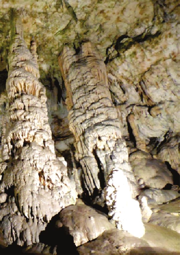
CONTENTS

FACULTY SECTION:
l AN ADVENTURE IN NATURE’S LAP, Soha Hossain

ALUMNI SECTION:
l CHOICE OF CONTRACEPTIVE METHODS IN ASIAN COUNTRIES:
   An Exploration into the Family Planning Programmes
   Aditi Kundu, Senior Research Fellow, Jawaharlal Nehru University, New Delhi.

STUDENTS’ SECTION:
l AIR POLLUTION IN KOLKATA - SEASONAL VARIATION:
   Enakshi Mukherjee, Krishti Rudra, Rachita Saha, Class of 2020
   [Paper presented at National Conference on Contemporary Research Perspectives in Geography]
l PHYSICO-ECONOMIC BACKGROUND OF VILLAGE BALLABHPUR: Suneha Ghosh, Class of 2020
l THE RAINBOW MOUNTAINS: Puspika Das, Class of 2021
l THE CARIBBEAN OF THE ALPS :Rajanya Manna, Class of 2021
l GROUND WATER MANAGEMENT: IF NOT NOW, THEN WHEN? IF NOT YOU, THEN WHO? :
   Sohini Chowdhury , Class of 2021
l THE DOOR TO HELL - Sreoshi Bhattacharya. Class of 2021
l CLIMATE CHANGE: Ahelee Bera , Class of 2022
l WILDFIRE : Gargi Adhikari, Class of 2022
l SHIFTING OF EARTH’S MAGNETIC NORTH POLE : Koyel Nath, Class of 2022
l CYCLONE FANI: Koyena Das ,Class of 2022
l CASE STUDY: THE INDIAN OCEAN TSUNAMI OF 2004 : Madhuleena Das , Class of 2022
l CYCLONE VAYU: Rajeshwari Chakraborty, Class of 2022
l THE ETERNAL BEAUTY OF CHOPTA VALLEY : Soumi Kayari, Class 2022

DEPARTMENTAL TOUR AND ACTIVITIES:
l PHOTO GALLERY OF DEPARTMENTAL ACTIVITIES, 2019
l INFLUENCE OF PHYSICAL SETTING ON SOCIO-ECONOMIC LIFE OF MAN IN DHADKA,
   PURULIA DISTRICT: Banani Das and Didhiti Das, Class of 2019

Published by : Department of Geography, Shri Shikshayatan College
Editors : Dr. Nivedita Roy Barman and Smt. Indu Mundhra
Cover Photograph : Postojna Limestone Cave, Slovenia l Photo credit : Dr. Susmita Sen
Printed by : Pratirup, 35 Nandana Park, Kolkata 700034
EDITORIAL

In continuation of the rich legacy of the ten earlier years, the Department of
Geography presents the 11th volume of VASUDHA, studded with thought provoking
and interesting articles, excursion reports and photographic representation of some
of the key activities held in the Department. The combined human capital of the
faculty, alumni and students of our department has contributed over the years
various scholastic and relevant articles in Vasudha, making the journal an item to
treasure for the next generation of geographers. As we moved from strength to
strength as an institution of academic excellence, we realized the need to document
our thoughts and progresses in our own ways for the progeny. Vasudha serves that
purpose magnificently and not only captures the intellectual ability in all of us, but
invariably provides a sneak peek into the DNA of the department and our view of the
subject and life in general. Vasudha audaciously proclaims how geographers think,
and what we are capable of contributing to the world.

It is imperative that compiling such a journal requires humongous effort from faculty,
students and many others. We gratefully acknowledge the contributions of one and
all and urge all our stakeholders to come forward and contribute more to this unique
initiative, such that our signature continues to leave a mark on this esteemed
institution. We take this opportunity to also thank the management of the college for
all their guidance and specially our Principal, Dr. Aditi Dey for her constant
encouragement in all activities of the department held throughout the year.

Congratulations to the team once again! We look forward to another great year of
cordial engagement and intellectual pursuit.
VASUDHA                                                                                       DECEMBER 2019

                            AN ADVENTURE IN NATURE’S LAP
                                                  Soha Hossain

    One of the most interesting parts of being a geographer is that we understand maps best and hence we can
plan our own tours and routes exploring new areas which are rarely explored. Shimla, Manali and Kasauli are
beautiful places which were part of my tour but I am sharing my experience about a place which is not very
                                                popular and not frequently visited, Tirthan Valley. While
                                                deciding the route to reach Manali from Shimla, I decided not to
                                                take the usual Chandigarh Manali highway. Instead I decided to
                                                go up towards Manali by taking a completely new route and
                                                come back via the usual Chandigarh Manali highway.
                                                    We reached Shimla by taking the toy train from Kalka which
                                                has been declared as World Heritage by UNESCO. Travelling
                                                amidst nature, on a track laid down almost 117 years ago it was
                                                quite exciting. The train passes through the woods crossing
                                                tunnels and bridges, all engineered during 1898-1903. It was
                                                delightful to observe the extent of surveying that was done for
                                                this train route to be constructed during an era when there were
                                                no modern equipments. The train crossed 103 tunnels and
                                                about 950 bridges, all built with absolute perfection and all well
             THE SELECTED ROUTE
                                                maintained as well.
    After spending a few days in Shimla we started our journey towards
Manali. Instead of taking the usual route taken by all, we started
moving towards the right of Shimla crossing Fagu and Narkand. Fagu is
famous for apple orchards. Narkand is called second Shimla, a place for
those who want to stay away from the busy and bustling towns. The
best place to be seen here is the Hatu Peak located at a height of 3400m
above MSL. The 360Ú view of the ranges from the peak is
                                                                             TOY TRAIN PASSING THROUGH THE WOODS
breathtakingly beautiful. Atop the peak is a temple of wooden
architecture dedicated to Hatu Mata. Some believe it is dedicated to
Goddess Kali and some say it is Mandodari, the wife of Ravana. And
near the temple is a stove like formations of rocks, believed by locals as
to be used by the Pandavas during their Agyaatwas. However after
descending down the peak we kept moving further north towards our
next destination Banjar in Tirthan Valley.
    After crossing Narkand, the road we took was no longer a highway
but was gradually becoming narrower. We crossed small villages                    VIEW FROM NARKAND PEAK

dotted everywhere with apple orchards, some in full bloom and some harvested. The ones ready to be
harvested were covered in nets from top to bottom so that it can be protected from birds, monkeys and most
importantly humans. After driving for three hours from Shimla we reached a small village, Thanedar where we
took halt for lunch. But there were no hotels, restaurants or dhabas. After talking with some people we found a

                                                         1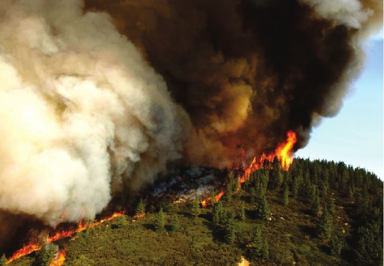
VASUDHA                                                                                        DECEMBER 2019

                                           small shop, where the lady in charge was cooking for herself and so
                                           we requested her to prepare lunch for us. So we had a delicious
                                           platter of roti, sarson da saag and paneer bhurji in homemade butter.
                                           This was a lunch I think I will remember forever which ignited my taste
                                           buds and the hospitality received was better than any five star hotel.
                                                 We left Thanedar behind and proceeded on our journey on the
                                             Ani-Banjar-Aut road. After an hour the road got narrower and the
                                             forest was getting denser. Now we were on a single road and we had o
            THE ISOLATED ROADS               stop if another car approached from the front and sometimes even go
reverse. A tributary of the Sutlej was flowing down in the valley going almost parallel with the road. There were
no villages in sight for hours and a car or two passed us after every one or one and a half hour. The only human
encroachment visible was the road on which we were driving. Though my Google map was still working but our
phones did not have any network connectivity. The range on the
other side of the valley had no signs of human encroachment at all.
It also seemed the region has experienced upliftment at places
because at sudden places the trace of the river valley could be seen
at quite a height from the valley floor and below it the entire slope
was devoid of any vegetation. I was not able to take photograph of
such a sight because my driver refused to stop. His refusal to stop
was logical because on the road sides foxes were roaming and were
not at all scared of a passing car. This again indicated that the
                                                                                 PASSING THROUGH THE FOREST
frequency of cars is very less on this road. Shimla to Tirthan valley
was supposedly a journey of six hours but after travelling for three hours from Thanedar we reached a village on
top of a hill from where our destination was still three hours more of driving. It was already evening, the sun had
almost set and we had a stretch of dense forest to cover before we reach our destination at Nagni village in
Gushaini, Banjar.
We had left the last village and did not see any for the next three hours. The road was ascending on a steep slope
with an angle of about 30Ú-35Ú. We were in Jalori on NH305 though it did not fulfil any criteria to be a national
highway. It was narrow, a mixture of mud and pebbles, full of pot holes and extremely bumpy. The car’s speed
was restricted to only 10kmph and had to drive in first gear. And as we were approaching the top of the hill our
driver complained that the ascent was very difficult and there were chances of slipping. The curves were
extremely dangerous. And then in the darkness, only lit by the car’s headlights we saw a dead end- a big boulder
and a waterfall. It was coming down forming a bed of water and flowing down the slope. On getting down from
the car we saw that hidden behind the big boulder was a narrow pass which is supposed to be our road, rather
NH305. So we crossed the river bed formed by the waterfall and traversed past the boulder. Later we came to
know this place as the Koth Nala, a place where accidents are most common even in bright daylight. Finally we
reached Jalori Top or Jalori Jot or Jalori Pass at a height of about 3120m. The descent down the slope from the
top was equally bad, even worse at places as the steepness was even 35-40 degress at the curves. But now
lights were visible down in the valley and we got the first glimpse of Tirthan Valley set in the heart of The Great
Himalayan National Park(GHNP) famous for being the home of leopards and snow leopards. Though the
descent too was dangerous and we had to go in the same speed but relief gradually was dawning upon us. We

                                                        2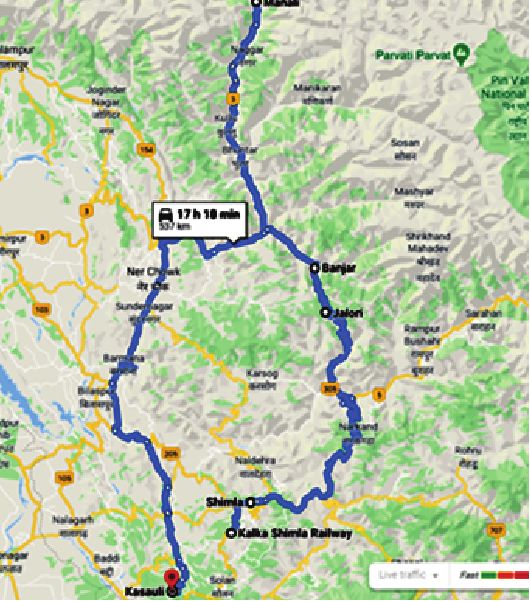
VASUDHA                                                                                          DECEMBER 2019

reached the first village Shoja, then further on we got Jibhi which is a favourite place for trekkers and hikers. The
next village was our destination on the Tirthan River bed and so we descended further. The slope was now
gentler and my driver was pretty annoyed with me for selecting such a dangerous route and I think that was
expected. We reached Banjar and from there to our destination Nagni village near Gushaini, a more interior
village at a distance of about 8km and a height of 1356m. Our homestay Tirthan Travel Nest actually felt like a
nest to us after such an adventure. Our hosts, Rajender ji and his wife, gave us a warm welcome and a
scrumptious kulluvi dinner was waiting for us. We settled in our room and could hear the passing Tirthan River.
We were given a warning though, to not open the doors at night because leopards roam outside on the roads
and even in the lawn. We learnt from our host that the road in Jalori is nicknamed as Death Road by locals and its
comes under the category of one of the most dangerous roads of the world.
                                            The morning was beautiful and serene waking up in a house inside the
                                       GHNP, the majestic ranges welcoming the morning’s first sun rays. After
                                       breakfast we went on a hike. The river was gurgling away. It was a small
                                       village with houses here and there and almost all of them serving as
                                       homestays. Apple,pear,cherry and persimon trees were in abundance
                                       everywhere. The river is famous for trout fishing , and some hikers were
                                       busy in that. It’s a trekkers paradise with waterfalls at a distance of 1 or 2
                                       km away , meadows and a glacier about 8km away. We walked on the
                                       unknown paths and
                                       everywhere there was
                                       greenery, fresh air and
                                       those ranges I would
                                       love to go again. All the
                                       adventure and tension
                                       of the previous day did
                                       not go in vain. Every bit
            RIVER TIRTHAN                                                    VIEW OF GHNP FROM HOMESTAY
                                       of it was worth it. We
halted only for a day and proceeded towards Manali the next day.

VILLAGE HOUSES DOTTED ON SLOPES      OUR HOMESTAY            HOMESTAYS ON THE RIVER BED       A NEARBY WATERFALL

          “ Do not go where the path may lead, go instead where there is no path and leave a trail.”
                                                                                    ~Ralph Waldo Emerson
Photo Credits: Author

                                                         3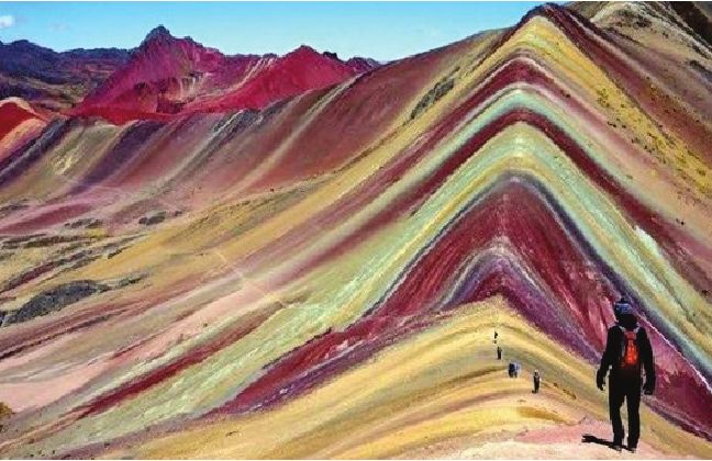
VASUDHA                                                                                             DECEMBER 2019

 CHOICE OF CONTRACEPTIVE METHODS IN ASIAN COUNTRIES:
 AN EXPLORATION INTO THE FAMILY PLANNING PROGRAMMES
  Aditi Kundu, Senior Research Fellow, Jawaharlal Nehru University, New Delhi, aditikundu31@gmail.com

     ‘Contraception’ as a technology bears different connotations to different people. To the government and
policy makers, it is just a tool for controlling the rising population; to a religious fundamentalist, it is a mere
nuisance as it aids in going against god’s will; to a prostitute, it helps in her uninterrupted business; to a seller, it
is a means of money making; to a woman it is a right to her own body and its reproductive system. It is such a
thing that if viewed from different coloured lens it will give diverse interpretations. For instance, it can be
looked through a gendered lens or from a planner’s perspective, from the angle of a business person to that of
any institutional organisation; be it a joint family structure to a religious organisation.
    Although the history of contraceptive stretches back to antiquity, now being part of modern medical
discourse it is not more than a century old. Contraceptives and family planning as part of population policy of
sovereign state policy is even more contemporary. Present work focuses on the historical context of
government policies and how it shapes the contraceptive method choice of the country. As existing literature
indicates, choice of contraceptive by a couple is a complex phenomenon that depends on a variety of factors.
This study tries to look into several elements of contraceptive choice, but from a steady vantage point of
government policies; it strives to explore how government policies manipulate the immediate factors and
indirectly guide couple’s choice of contraceptive.
    In this endeavour, the issue is approached from couple’s perspective as well as from government’s or the
provider’s perspective. A couple tries to use contraceptive for either limiting or spacing childbirth. However,
when they decide to use a contraceptive, there lies a host of factors leading to adoption of one method over
another. There are four primary considerations; accessibility, affordability, perception and personal
preference. A deliberation of these issues governs the contraceptive choice of a couple.
     On the other hand, state’s attention on the issue of family planning stems from three different rationales;
demographic (to control the population growth of the country), reproductive health (to improve the condition
of maternal health) and as human rights (owing to the argument that controlling one’s fertility is a fundamental
right). Whatever the motivation might be, instruments to arrive at the selected goals is always to promote the
use of contraceptives. There lies a host of mechanisms through which state can promote the contraceptive use
in the country which is again clubbed into four chief ones; increasing availability by improving service delivery,
partly or fully subsidising the contraceptives to make it more affordable, popularising certain contraceptive(s)
through awareness campaigns, provide incentives for adoption of a specific method.
    All the steps taken by government to promote contraceptives, is particularly aimed at influencing one or
more factors that couples consider before choosing their preferred contraceptive method. This paper
attempting to identify the factors that lead to majority couples in a specific country choosing a specific
contraceptive, looked mainly from the vantage point of government actions.
Discussion
A careful study of government policies reveal family planning programmes and policies that provide only a
partial causation to the couples in determining their choice of contraceptive method. In most of the countries,
it has been observed that guideline behind the ultimate choice of contraceptive method is the interplay of

                                                           4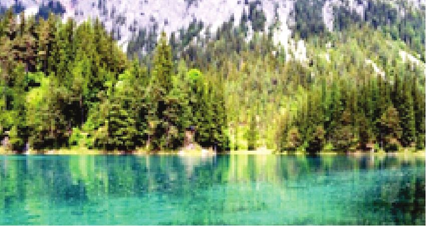
VASUDHA                                                                                            DECEMBER 2019

socio-economic-cultural
and psychological factors;                                            Government’s Policy
which in turn are gradually

                                   Rational
                                                   Demographic         Reproductive Health         Human Rights
shaped by family planning
policies or a lack of such
                                                                   Promoting Contraceptives
government initiatives. In

                                  Implementation
some of the countries, the                  Subsidization         Delivery          Popularization      Incentivization
scenario is such that
certain external agents act
                                                                           Contraceptive
behind the stage and                                                      Method Chosen
moderate the couple’s
contraceptive behaviour                    Affordable Cost    Available Supply    Positive Perception  Choice Exercise
                                   Individual Level

by and large. Moreover,
the point that is to be kept                                            Contraceptive Need

in mind is that there is no                                    Limiting                    Spacing
single reason explaining
or a dominant factor                                                     Couple’s Choice

leading to the particular
choice of contraceptive by a couple. Even if we need to agree that different factors play in shaping the
contraceptive choice but ‘the role of state’ remained, either actively in some countries or passively in others.
So, following this, several highlights is made and discussed from hereon.
    State versus Donor Agencies: There lies a stark difference in the contraceptive choice depending on the
major source of funding. If government is the main support, then a single contraceptive method is seen to be
dominant in the land. On the other hand, if the financial aid is of some donor agencies, such as UNFPA, USAID,
UNICEF, WHO or similar, then a combination of methods is seen to be present and no single method is ruling
over. As in the countries having the oldest family planning institutions such as that of India or Sri Lanka, there
has been a single method rigorously promoted in the country.
    Direct State Intervention: Reward and Incentive or Coercion and Disincentive: Active or direct measures
by which state intervenes is promoting contraceptives by subsidizing, rewarding or penalizing. Certain
countries give benefits to people for limiting their family size whereas in some pro-natalist countries, it has also
been seen that government penalizes or punishes for using contraceptives to regulate their fertility behaviour.
Examples of reward oriented family planning programmes are India, Bhutan, Sri Lanka or Nepal; where
government of Bhutan gave four dollars to the acceptors of sterilisation and Sri Lanka government gave cash
prizes to the medical professional team for fulfilling their sterilisation targets. India sitting in the midst of the
SAARC countries and being one of the population giants have adopted different methods of rewards and
bonuses from giving cash prizes to people accepting sterilisation as well as inserting IUD to even lotteries of cars
for women undergoing sterilisation. Although it claims to have a proper cafeteria approach, but it has histories
of forcefully sterilizing people, even zero parity women. In the present also, it organizes sterilisation camps
where men and women are sterilized for free but the entire procedure is conducted in such an unhygienic
condition that several women die as a result of unsuccessful operation.
Legalisation or Criminalisation: After direct intervention, the next most effective method for a government to

                                                          5
VASUDHA                                                                                             DECEMBER 2019

dominate the contraceptive choice is via legal mandate. This is mostly for restricting a certain contraceptive to
be used in a country rather than for promoting contraceptives The best example of legal manipulation is seen in
Japan, where Japanese government conveniently banned all types of contraceptive except condom, and very
obviously most of the contraceptive users chose condom as their preferred birth control method. Iran and
Turkey also present cases where sterilisation remained banned for a long period of time, based on religious
ground, and in the years immediately after their legalisation, use of permanent methods underwent a major
surge in both the countries. A similar process is also observed for using intra-uterine devices in Mongolia. There
are certain countries such as Azerbaijan where to use contraceptives; people need a medical prescription from
a registered gynaecologist and obstetrician. Therefore, governments use this as a measure to control the use of
contraceptives or certain contraceptives with a deeper policy implication in mind.
Availability and Acceptability: both Geographical and Social: If the government of a country promotes
contraceptives and makes it available, then it becomes easier for people to use. Otherwise, it is not only that
people need to have proper knowledge and awareness about using contraceptives but getting them at an
affordable price and nearby to one’s residence, which is also a necessity. If direct intervention does not operate
in the country by the government, then the major determinant that helps a couple in choosing the desired
contraceptive is the geographical availability and the social acceptability. Socio-psychological cost in most of
the cases surpasses even the direct physical cost that is borne by a user.
Affordability: The Public Sector Boost: Even when most of the methods are physically available and socially
acceptable, there still lies a major barrier in financial affordability. It is seen that if a particular contraceptive is
available at a much cheaper rate in comparison to other contraceptives, then most of the people of that land
have a tendency to rely on it in respect to all other choices. However advantageous the other contraceptives
might be or even if the cheapest one does not fulfill the need of the user, even in that case it has been noticed
that the cheapest one becomes the dominant contraceptive of the region. Such has been the case when oral
pills became freely available in Bangladesh which being marketed by a non-profit organization became the
dominant contraceptive in a very short span of time.
Knowledge and Socio-psychological barriers to contraception: Even if all the contraceptives are equally
available in the country with a bare minimum cost and a proper cafeteria approach is followed, then also
perception about contraceptive and a difficulty to overcome social, cultural and psychological barriers
becomes a major deterrent. Knowledge regarding contraceptives, perception about contraceptives and
choosing an appropriate method is a major task for a user. In most of the cases, it is observed that people are
aware of almost all the available methods but the contraceptive acceptability becomes difficult. People are
afraid of their perceived side effects that might hamper their lifestyle and the fear of which stops them from
protecting themselves.
Abortion and IUD: This is an interesting scenario in countries such as Vietnam, Uzbekistan, Tajikistan,
Kazakhstan, Kyrgyz Republic which presently has a sweeping dominance of IUD use have a precarious history of
rampant and unsafe abortions. Rate of abortions in all these countries remained very high and whenever the
women go to the clinics for medically terminating their pregnancies, an IUD is inserted in their uterus with due
permission from them.
Post Decline Transition: The historicity of a region becomes very important to understand any behaviour of
that land. No study on a region can be conducted negating its past history. The present scenario of a region

                                                           6
VASUDHA DECEMBER 2019
cannot be explained without the temporal story. Presently if a country has achieved the replacement level
fertility, the government might not be very active in promoting contraceptives but history might unfold a
different story as has been the case of Sri Lanka. Presently, Sri Lanka has a considerable share of hormonal and
traditional contraceptive users to go alongside the majority of people who have opted for sterilization but on
the other hand its fertility transition took place almost exclusively with female sterilisation. The Sri Lankan
government actively promoted sterlisation at the cost of other methods but now have supressed due to its
already controlled fertility behaviour.
Therefore, it is seen that a vast array and interplay of factors play hand in hand in shaping the contraceptive
behaviour of a region with the role of state remaining an important position in deciding a contraceptive choice.
This particular work has tried to unravel another layer to the already exisiting list of factors affecting the
couples’ contraceptive choice behaviour. It tries to establish that directly or indirectly the government occupies
an important position in moulding the choices of couples contraceptive habit.
References-
Bulatao, R. A., Palmore, J. A. and Ward, S. E. 1989. Choosing a Contraceptive: Method Choice in Asia and the
United States. Westview Press, San Francisco, USA.
Kundu, A., and Das, B. (2019). Population, Fertility and Family Planning. Rawat Publications.
Robinson, W. C., and Ross, J. A. (Eds.). (2007). The global family planning revolution: three decades of
population policies and programs. The World Bank.
XXXXXXX
7VASUDHA DECEMBER 2019
AIR POLLUTION IN KOLKATA - SEASONAL VARIATION
Paper presented at National Conference on Contemporary Research Perspectives in Geography
Enakshi Mukherjee, Krishti Rudra, Rachita Saha, Class of 2020
Air quality in most mega cities has been found to be critical and Kolkata is no exception. Among all the pollutants
in the air of Kolkata, this paper discusses seasonal variation of the most predominant pollutant, Suspended
Particulate Matter (PM ). The paper attempts to investigate the spatial distribution and seasonal variation of
10
particulate matter in the city. It also aims to examine compliance of air quality standards set, vehicular emission
and increasing constructional activities. Amount of PM has shot up in the city and its fringes over the past few
10
years. PM effects both – human health (triggering a variety of pulmonary diseases) and the environment
10
severely. The data used in the paper was collected from 14 air quality monitoring station under WBPCB (West
Bengal Pollution Control Board) and 2 under CPCB (Central Pollution Control Board). The assessment of air
pollution level has been computed by applying the Exceedence Factor (EF) method introduced by CPCB, which
is (Observed mean concentration of pollution / permissible standard for the respective pollutants) *100. Based
on the EF in percentage spatial distribution maps have been prepared for monsoon and winter seasons showing
4 broad air pollution zones in each map that is very safe, safe, moderate and less polluted in monsoon and
polluted, highly polluted, critical, hazardous in winter prepared with Arc GIS version 10.1.3 . Pollution rises to
the maximum in winter and reduces to minimum in monsoon impacting seasonal human health of city.
Northern and South western fringe of city show the highest concentration of SPM in both the seasons and
hence falls in the hazardous zone. The reasons being Cossipore thermal power plant in the north and industrial
belt of south west which are stationary sources of pollution. Relatively less polluted zones are the central and
eastern fringe of the city. A stringent policy portfolio involving various mitigating cost effective measures are
necessary to control the negative impacts of air pollution due to excessive rise of PM 10.
Analysis :
In the monsoon months of
July, August and September, the
wet deposition of the pollutants
results in a great reduction of
their concentration in ambient
air in almost all parts of the city.
During this time, the sea winds
from the south also result in
greater atmospheric dispersion
of the pollutants in a northerly
direction as a result of which the concentration of pollutants within the city remains well within the permissible
limit. The pollution zoning map for this season shows 4 zones in Kolkata all of which are safe as per the
permissible standard set by WHO at 140 ìg/m . Among the Air Quality Monitoring Stations, Rabindra Bharati
3
has the highest level of particulate matter followed by Hyde Road, both of which have very old power plants
and industrial areas in their vicinity. On the other hand, the wide green fields of the Victoria Memorial along
with the adjacent areas of Maidan and Race course near the River Hugli along with the eastern part of the city
with the presence of the Kolkata Wetlands records the lowest concentration of particulate matter.
In the winter months of December, January and February, however, the situation is reversed. Pollutant
8VASUDHA DECEMBER 2019
values are invariably higher in all the Air Quality Monitoring Stations crossing the permissible standard of 140
ìg/m by high margins. It happens when the wind speed is lower and thermal inversion takes place in the
3
evening over a period of time. During this time due to low humidity and high dryness, the particulate matter
along with the dust particles remain suspended in the lower layers of the atmosphere. The pollution zoning
map for this season has been prepared showing polluted, highly polluted, critical and hazardous zones of
Kolkata. Hyde Road industrial area has the highest level of particulate matter followed by Rabindra Bharati
located close to the old thermal power station at Cossipore established in 1949. The heaps of fly ash generated
and dumped near the power plant become airborne with the passage of wind and add to the SPM level of the
area. The roads here are unmetalled and every time heavy vehicles pass the area, huge amount of dust is
generated. The south eastern fringe of the city around Baishnabghata, shows relatively lower pollution due to
fewer residential area and thus relatively less traffic. The open patch of greenery around the Victoria Memorial,
Race course and Maidan also records low concentration of particulate matter even in winter.
Conclusion:
It is undeniable that the air quality of Kolkata varies significantly between the monsoon and winter seasons.
The indiscriminate discharge of particulate matter from industrial, vehicular and domestic sources have
resulted in the deterioration of the air quality of Kolkata at an alarming rate. The situation is likely to aggravate if
immediate ameliorative measures are not taken in this respect. The environmental planners need to adopt the
most cost-effective approaches to control industrial, vehicular and domestic emissions considering the fact
that Kolkata acts as a nerve centre providing the lifelines that link the country together and hence should
receive immediate national attention.
Acknowledgement:
We would like to take this opportunity to thank the Principal of Shri Shikshayatan College, Dr Aditi Dey; our
supervisor for this project, Dr Nivedita Roy Barman for inspiring us to work on this topical subject. We are
grateful to Ms Triparna Barman, School of Oceanographic Studies, Jadavpur University for preparing the maps
of this paper. agreeing to collaborate with us in studying the spatial distribution of air pollution in Kolkata. We
are immensely indebted to Dr Kalyan Rudra, Chairman, West Bengal Pollution Control Board for helping us in
data collection and analysis.
Bibliography
Chakraborti, S. “Air Pollution level in Kolkata among country’s highest” Times of India, Jan 3 (2017)
Gokhale, S. Khare, M. “A theoretical framework for the episodic-urban air quality management plan (e-
UAQMP)” Atmospheric Environment, 41 (2007), pp.7887-7894
Gulia, S. Shiva Nagendra, S.M. Khare, M. Khanna, I “Urban Air Quality Management” Atmospheric Pollution
Research, Vol 6, Issue 2, (Mar 2015), pp286-304
Md. Senaul Haque and Singh R.B. “Air pollution and Human Health in Kolkata, India: A case study” ‘Climate’
(Oct, 2017)
Nivedita Roy Barman, “Air pollution Hotspots of Kolkata”. UGC-MRP (2004)
Spiroska, J.Rahman, M.A. Pal, S. “Air Pollution in Kolkata: An analysis of Current Status and
XXXXXXX
9VASUDHA DECEMBER 2019
PHYSICO-ECONOMIC BACKGROUND OF VILLAGE BALLABHPUR
Suneha Ghosh, Class of 2020
The small village of Ballabhpur with a population of about 500 persons, is at the outskirts of Shantiniketan (
Bolpur) in the district of Birbhum. The district of Birbhum is a region of lateritic and red soil as it is a
continuation of the Chotanagpur plateau. The district is drained by numerous rivers like Ajoy, Kopai, Khoai,
Brahmi and Bakreshwar rivers. Although the soil is not so fertile but with the help of irrigation facilities, the
peasants cultivate paddy, vegetables and pulses for their consumption. The main source of irrigation is the
canal irrigation under the Mayurakshi River valley project, the Tilpara Barrage. Apart, from this, well irrigation is
also carried out. Hence, agriculture is the mainstay of the people in the district. The village Ballabhpur holds a
number of handicraft industry like terracotta, pottery, silk wearing kantha stitch, basket wearing, which is
carried out at the households of the peasants and even at Amar Kuthi workshop. The women folk are mainly
trained and employed at Amar Kuthi. The roads are unmetalled and cart tracks are found. The ground water is
the main source of drinking water. The villages still experiences the fluctuating supply of electricity. There is
only one hospital at Shantiniketan and the other at Siuri for away from the village. Most of the houses are
kutcha houses with sheds where they domesticate cows, buffaloes for acquiring milk. There are three middle
schools at Shantiniketan 100km away from the village. There is only one primary school in the village.
PROBLEMS
As a part of a team of students of St. Teresa Secondary School of class XIIB, I had gone for a geography
excursion to the village of Ballabhpur, situated few kilometers away from Shantiniketan, for conducting a socio-
economic survey.
After survey, when the final primary data was gathered from 48 families, it was found that, the families had
a low capita income, Though some families were well off while the others lived below poverty live.
It was surveyed that many of the families did not have proper electricity supply and most of them did not
have gas oven. Some of the houses did not even have proper water supply. The families were to a great extent
male dominated who worked for most part of the day while the women remained at home. Those who were
employed did not have adequate income to fulfil all the needs and aspirations of their families and hence
proverty prevailed. Most of the workers of the village were employed in the Amarkutir leather workshop which
provides employment equally to both the genders. Infact, this workshop encourages females more than males.
The literacy rate among the male is more than that among the females. The younger women are quite
educated which indicated that the status of women in the village has developed quite a lot. They are also
sending their children to pre-school and hence one cannot say that people of Ballabhpur are not educated.
Although the village is more advanced compared to the other grass root level villages, it cannot be
considered as a developed village of the area. Hence for overall development there should be more industries,
workshops, cottage industry providing scope for easy employment for the village folks, both skilled and
unskilled. Though people have basic literacy, they are not enough educated to get proper job. Moreover, there
are many who are uneducated, thus, education facilities need to reach every corner of the village. The
Panchayat should take adequate initiative towards the education of children. They should encourage
education of particularly the girl child for brighter future of the nation.
PROSPECTS:
Amarkutir, located on the banks of Kopai river about 15 kms from Shantiniketan in Birbhum distrct in the State
of West Bengal is a co-operative unit that produces leather goods, kantha stitched sarees, bamboo crafts and
10VASUDHA DECEMBER 2019
batik at a reasonable price. A few kms away from the workshop , is a leather factory where the commodities are
made.
It was started by Sri Sushen Mukherjee in the year 1927. This industry provides employment to a large
number of villagers. The factory provides employment to both male and female workers, skilled and unskilled
labours. This industry encourages female employment to a great extent. The employers are divided into groups
and each group is allotted stitching, colouring, giving shape and print on various ethnic items.
However, now it has developed as an autonomous body known as “Amarkutir Society for Rural
Development” and this has really gifted some prosperity to rural people of the area.
XXXXXXX
11VASUDHA DECEMBER 2019
THE RAINBOW MOUNTAINS
Puspika Das, Class of 2021
Introduction
One of the most magnificent geologic features in the world is the Ausangate of the Peruvian Andes, also
known as the “Rainbow Mountain”, has the breathtaking geological attributes. The mountain is striped with
colours ranging from turquoise to lavender to maroon and gold. However, this “painted mountain” is
notoriously difficult to find and get to, requiring several days of hiking to reach its peak deep within the Andes
by the way of Cusco. It sits at an elevation of 6,384 meters (MSL), located approximately 100 km southeast from
the nearer major city, Cusco.
History
The Andes are an incredibly complex mountain chain that extends along the western edge of the South
American continent. The subduction of the Nazca plate underneath the South American plate initiated the
mountain building and upliftment of the range, resulting in significant volcanism and the introduction of rare
and varied mineralogy to the Andes Mountains. The reason for the colouration in the stratigraphic layers of the
Ausangate Mountain is due to weathering and mineralogy. But this part of the Peruvian Andes was concealed
underneath ice and snow until recently in 2015, when climate change caused the glaciers to melt and revealed
this geological wonder, which has now become one of Cusco city’s most popular attractions.
Creation
The beautiful colouration of these mountains includes the colours of rainbow (red, yellow, green) which
have been explained by various scholars and researchers. The red colour of sedimentary layers often indicates
iron oxide rust as a trace mineral; the goethite or oxidized limonite caused to introduce a brownish colouration
to sandstones; the bright yellow could be due to iron sulphide as trace minerals within the pore cement and the
varying shades of green colour are related with the presence of chlorite in different diagenetic states as well as
concentrations. Thus, rainbow created by nature in Ausangate is popularly known as the “Rainbow Mountain”
worldwide.
Climate and Weather
The annual weather in the area of Rainbow Mountain Peru usually has two long seasons: the dry and the
wet. The dry season goes from May to November, mostly sunny with minimum percentage of rain or,
precipitation, recommended time to trek. But the rainy (wet) season is usually considered from December to
April with hail storms, snowing, cloudy days causing less visibility on the mountains. Travellers visiting the
mountains should have some preparation for the quick change of temperature as well as weather even in
winter. Due to the global warming, the weather condition in the Andes is becoming very changeable and
unstable also unpredictable.
Anthropogenic Exploitation
The colourful Andes mountain receives some 1500 daily visitors. It become richer with crowd in recent
past, when the site soared to its popular status and travel operators began to offer daily hikes towards the end
of 2015. While it is growing in popularity with tourists, it has led many to feel concerned for the mountain’s
protection. It has also been seen that the trail that hikers traditionally take up the mountain has been badly
eroded by the combination of visitors and horses that are used to carry people up the ascent. The community
has also built a sizeable gravel-filled parking lot to accommodate the increase in traffic to the area which had
12VASUDHA DECEMBER 2019
previously been an important wetland for various animal species that lived in the area. Over tourism is not the
only threat on the horizon for Peru’s Rainbow Mountain. To cite for example, a Canadian-based mining
company, named Camino Minerals Corporation, has applied for permission to mine minerals in the surrounding
area, including on the mountain itself due to the abundance of copper and iron ore.
Conclusion
The importance of this landscape lies on the many layers of the Peruvian Painted Mountain where millions
of years of history and all the complexities that are associated therein. In order to preserve this beautiful natural
wonder of the world the government should take some steps. Since, the number of tourists visiting the area has
become overly burdensome, they could install a permit system. A permit system would help to control visitor
numbers while providing a source of income for the local community, as well as funds for the maintenance and
conservation of Rainbow Mountain. On November 23, 2018, a presidential decree by the Peruvian government
declared a mining ban for the next 12 months. This is probably one of the major steps taken by the government.
Understanding the environmental and geologic conditions that formed the rock units is one of the key building
blocks of geology which allow for better understanding our world long before humans walked this green Earth.
Reference
Ø https://www.forbes.com/sites/trevornace/2017/01/21/welcome-rainbow-mountains-peru/
Ø https://geologyhubblog.wordpress.com/2017/09/22/the-rainbow-mountain-of-peru/
Ø https://www.lonelyplanet.com/articles/perus-rainbow-mountain-environmental-concerns
Ø https://www.topperutrips.com/blog/weather-rainbow-mountains-peru/
Ø https://theculturetrip.com/south-america/peru/articles/the-discovery-of-perus-rainbow-mountain-has-
an-unfortunate-truth/
Ø http://www.newperuvian.com/the-rise-of-rainbow-mountain-in-peru/
XXXXXXX
13VASUDHA DECEMBER 2019
THE CARIBBEAN OF THE ALPS
Rajanya Manna, Class of 2021
INTRODUCTION :
Every spring, melting snow creates a dreamscape in Austria. Grüner Sea also known as Green Lake is a lake
in Styria, Austria in a village named Tragöess. It became popular in 2016 and since then has become a major
spot in world tourism. Nature has formed plenty of water features that seem anything but natural like the
Blood-red waterfall in Antarctica. But , this lake has an even cooler trick than other; at the same time of every
year, it overflows to seven times its depth and the disappears almost completely on its own.
ABOUT THE EXTRAORDINARY
LAKE:
The Green lake spends its
falls and winters as a mild
mannered lake of a few metres
while it transforms itself into a
10 m deep lake during the spring
or early summer. The lake is also
famous for its emerald-green
waters apart from the fact of an
usual spring transformation.
GREEN LAKE DURING WINTER Every spring , when the
phenomenon of snow melting takes place in the Hochschwab mountains, Grüner Sea collects all waters and
floods the bigger part of the park.
During winters, it is a good place for an Alpine
hike. In the mountains with crisp air, away from the
city, visitors go for a day of walking around the small
body of water, a mountain meadow, and the forest
around it. However, during the warmer months as
snow starts to melt, water covers the entire area. A
number of trees, benches, bridges and flowers are
covered with around 40 feet of water. Visitors from
around the world trade in hiking boots for flippers
and scuba gear and dive around the suddenly
GREEN LAKE DURING SPRING
impressive-sized lake. Fish swim around park
benches and swimmers float over bridges. The bottom is covered in grass, giving much of the lake a green hue,
as well as lending to its name.
The natural phenomenon creates an almost surreal underwater park until July, when the water begins to
evaporate again, restoring park access to land lubbers. Since the water is snowmelt, therefore it is extremely
cold and incredibly clear. This high visibility (upto 160 feet) is actually what lent the lake its eponymous colour
and eventually its nickname: ‘ The Caribbean of the Alps ‘.
14VASUDHA DECEMBER 2019
The lake supports some aquatic life as well apart from being just a picturesque lake, such as small fish,
underwater insects and some trout. The appealing magical, emerald-toned lake attracted too many tourists,
and this lake became a hotspot for divers. However, the local tourism office imposed certain restrictions due to
widespread human activities.
CONCLUSION:
Despite Green lake being famous for its crystal clear water, some recent activities have made its
mesmerising clear water turn opaque due to an increase of algae and urine in the water. Hence, it is of utmost
importance that necessary measures are taken to conserve this spectacular and much photographed place.
BIBLIOGRAPHY
l www.dailymail.co.uk/travel
l www.travelandleisure.com
l Travel tips and country facts by Datacube ( YouTube )
XXXXXXX
15VASUDHA DECEMBER 2019
GROUND WATER MANAGEMENT: IF NOT NOW, THEN WHEN?
IF NOT YOU, THEN WHO?
Sohini Chowdhury, Class of 2021
Groundwater is a valuable resource both in the United States and throughout the world. Groundwater
depletion, a term often defined as long-term water-level decline caused by sustained groundwater pumping, is
a key issue associated with groundwater use.
Causes of Ground water Depletion-
1. Groundwater depletion most commonly occurs because of the frequent pumping of water from the
ground.
2. We continuously pump groundwater from aquifers and it
does not have enough time to replenish itself.
3. Agricultural needs require a large amount of groundwater.
Effects of ground water depletion-
1. Water-well problems
2. Reduced surface-water flows
3. Subsidence
4. Deterioration of water quality
Pumping groundwater faster than it can recharge
5. Land Subsidence can lead to dry wells, especially during droughts.
(Credit Wikipedia, Creative Commons)
Easy ways to restore ground water-
Ø We should use native plants in your landscape. They look great, and don’t need much water or fertilizer.
We must also choose grass varieties for our lawn that are adapted for your region’s climate, reducing the need
for extensive watering or chemical applications.
Ø We must use fewer chemicals around our home and yard, and make sure to dispose them off properly
without dumping them on the ground.
Ø Potentially toxic substances like unused chemicals, pharmaceuticals, paint, motor oil, and other
substances must be properly disposed off. Many communities hold household hazardous waste collections or
sites. We need to contact our local health department to find ones, near us.
Ø We should shut off the water when we brush our teeth or shaving, and not let it run while waiting for it
to get cold.
Ø We must check all the faucets, fixtures, toilets, and taps in our homes for leaks and fix them right away,
or install water conserving models.
Ø We should limit ourself to just a five minute shower, and challenge our family members to do the same.
Also, make sure to only run full loads in the dish and clothes washer. We have to water the lawn and plants
during the coolest parts of the day and only when they truly need it. Make sure we all, obey watering
restrictions during dry periods.
Ø We must reduce the amount of “stuff” you use and reuse whatever we can. Recycle paper, plastic,
cardboard, glass, aluminum and other materials.
16VASUDHA DECEMBER 2019
Ø We should use all natural/nontoxic household cleaners whenever possible. Materials such as lemon
juice, baking soda, and vinegar make great cleaning products, are inexpensive, and environmentally-friendly.
Conclusion-
India is in the midst of one of its worst and most serious water crisis. Newspaper dailies are churning reports
filled with images of hundreds of people waiting for water tankers or queued in front of a single tap which is
incapable of fulfilling the demand. By 2020, 21 major cities including Delhi, Bengaluru, Chennai, Hyderabad and
other states will run out of groundwater according to the Composite Water Management Index (CWMI) report
released by the Niti Aayog in 2018.The Niti Aayog CWMI report is a timely reminder for us to mend our ways and
take urgent measures to avert the crisis of our own making.
References:
https://ceoworld.biz/2019/10/10/indias-water-emergency-a-call-to-action/
http://cgwb.gov.in/hindi/faq.html
https://www.conserve-energy-future.com/causes-effects-solutions-of-groundwater-depletion.php
https://www.usgs.gov/special-topic/water-science-school/science/grou
XXXXXXX
17VASUDHA DECEMBER 2019
“THE DOOR TO HELL”
Sreoshi Bhattacharya, Class of 2021
The Darvaza gas crater known locally as the “Door to Hell” or ‘’Gate of Hell”, is a natural gas field collapsed
into an underground cavern located in Derweze, Turkmenistan. Geologists intentionally set it on fire to prevent
the spread of methane gas, and it is thought to have been burning continuously since 1971. The diameter of the
crater is 69 metres (226 ft), and its depth is 30 metres (98 ft). The crater is a popular tourist attraction. Since
2009, 50,000 tourists have visited the site. The gas crater has a total area of 5,350 m. The surrounding area is
also popular for wild desert camping.
The gas crater is located near the village of Derweze, also known as Darvaza. It is in the middle of the
Karakum Desert, about 260 kilometres (160 mi) north of Ashgabat, the capital of Turkmenistan. The gas reserve
found here is one of the largest in the world. The name “Door to Hell” was given to the field by the locals,
referring to the fire, boiling mud, and orange flames in the large crater, which has a diameter of 70 metres and
to a depth of about 20 metres.
According to Turkmen geologist Anatoly Bushmakin, the site was identified by Soviet engineers in 1971. It
was originally thought to be a substantial oil field site. The engineers set up a drilling rig and operations to
assess the quantity of oil available at the site. Soon after the preliminary survey found a natural gas pocket, the
ground beneath the drilling rig and camp collapsed into a wide crater and was buried.
Expecting dangerous releases of poisonous gases from the cavern into nearby towns, the engineers thought it
best to burn the gas off. It was estimated that the gas would burn out within a few weeks, but it has instead
continued to burn for more than four decades.
The early years of the crater’s history are
uncertain. local geologists say the collapse into a
crater happened in the 1960s, and the gases were
not set on fire until the 19 century.
The crater was featured in an episode of the
National Geographic Channel series Die Trying. In
the July 16, 2014 episode “Crater of Fire”, explorer
George Kourounis became the first person to ever
set foot at the bottom, gathering samples of extremophile microorganisms.
Effects on future development of gas
On President Berdimuhamedow’s April 2010 visit, he recommended that measures be taken to limit the
crater’s influence on the development of other natural gas fields in the area. At that time, Turkmenistan
announced plans to increase its production of natural gas, intending to increase its export of gas to many
countries such as Pakistan, China, India, Iran, Russia, and Western Europe, from its then yearly production level
to a new production level of 225 billion cubic metres by 2030.
BIBLIOGRAPHY
l www.thedoortohell.com
l www.craterofturkmenistan.com
XXXXXXX
18VASUDHA DECEMBER 2019
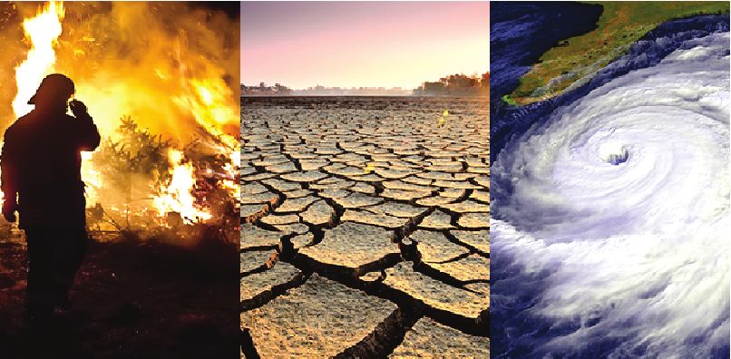
CLIMATE CHANGE
Ahelee Bera , Class of 2022
INTRODUCTION
Climate Change is the defining issue of our time and we are at a defining moment. From shifting weather
patterns that threaten food production, to rising sea levels that increase the risk of catastrophic flooding, the
impacts of climate change are global in scope and unprecedented in scale.
Without drastic action today, adapting to these impacts in the future will be
more difficult and costly.
HISTORY OF EARTH’S CLIMATE CHANGES
20,000 years ago, the earth was a frigid landscape. Huge ice sheets several
thousand meters thick, encased parts of North America, Asia and Europe. We
commonly know it as the ice age but geologists call it the last glacial maximum.
Over the last million years there have actually been about ten different
glacial maximums. Throughout the earth’s history climate has varied greatly. The problem of climate change
For hundreds and millions of years the planet had no polar ice caps. Without is very serious
this ice, the sea level was 70m higher. At the other extreme, about 700 million years ago, earth became almost
entirely covered in ice during an event known as ‘snowball earth’. So, what causes these massive swings within
the planet’s climate? One of the main drivers is atmospheric carbon dioxide -a green house gas that traps heat.
Natural processes such as volcanism, chemical weathering of rocks and the burial of organic matter can cause
huge changes in carbon dioxide levels when it continue for millions of years.
Over the past million years carbon dioxide level had been relatively low and repeated glacial maximums
have been caused by cycles and earth’s movement around the sun. As earth rotates it wobbles on its axis and its
tilt changes altering the amount of sunlight that strikes different parts on earth’s surface. These wobbles
combined with earth’s elliptical orbit cause summer temperatures to vary depending on whether the summer
solstice happens when earth is closer or further from the sun.
CAUSES AND EFFECTS OF ICE AGE
Approximately every 100,000 years, these factors align to create dramatically colder conditions that last
through a millennium. Cool summers that are not warm enough to melt the preceding winter snow allow ice to
accumulate year after year. These ice sheets provide additional cooling by reflecting more solar energy back
into space. Simultaneously cooler conditions transfer carbon dioxide from the atmosphere to the ocean
causing even more cooling and glacial expansion.
CLIMATE IN RECENT AGES
About 20,000 years ago, these trends reversed when changes in earth’s orbit increased summer sunshine
over the giant ice sheets and they began to melt. The sea level rose 130m and carbon dioxide was released from
the ocean back into the atmosphere. By analyzing pollen and marine fossils, geologists can tell that
temperatures peaked about 6000 years ago before another shift in earth’s orbit caused renewed cooling.
CLIMATE CHANGE IN FUTURE
So what’s coming next? Based on the repeated natural cycles seen in the climate record we would normally
19VASUDHA DECEMBER 2019
expect the earth to continue a trend of gradual cooling for
the next few thousand years. However, these cooling
abruptly reversed about a 150 years ago. Why? The carbon
dioxide levels in the atmosphere have been rising since the
19 century when use of fossil fuel increased. We know that
th
from the study of air bubbles trapped in Antarctic ice.
This surge in carbon dioxide also coincides with global
temperature increase of 1degree celsius. Atmospheric
Carbon dioxide level increase from 1960 to 2016 monitoring centers show that carbon dioxide levels are
increasing rapidly and are at a higher level than at any point in the last 800,000 years.
Computer models from the Intergovernmental Panel on Climate Change (IPCC) forecast another 1-4degree
celsius warming by the year 2100 depending on how much additional fossil fuel we burn. What does that mean
for the ice currently in Greenland and Antarctica ? The past
climatic changes suggest that even a small warming shift can
begin a process of ice melt that continues for thousand of years.
By the end of this century ice melt is expected to raise the sea
level by 30-100 centimeters, enough to impact many coastal
cities and island nations. If a 4 degree celsius warming persisted
for several millenniums the sea level could rise as much as 10m.
By studying past climates, scientists learned more about what
drives the shifts in ice that has shaped our planet for millions of Increase in sea level from 1993 to present
years. Research suggests that by taking action now to reduce carbon dioxide emissions quickly, we still have the
opportunity to curb ice loss and save our coastal communities.
CONCLUSION
Global climate change has already had observable effects on the environment. Glaciers have shrunk, ice on
rivers and lakes is breaking up earlier, plant and animal ranges have shifted and trees are flowering sooner.
Effects that scientists had predicted in the past are now occurring: accelerated melting of polar ice cap,
accelerated rise of sea level, and longer and more intense heat waves.
The countries from all over the world are trying to bring this problem under control by signing pacts and
agreements, the most recent being the Paris Agreement. At the 21st Conference of the Parties in Paris in 2015,
Parties to the UNFCCC reached a
landmark agreement to combat climate
change and to accelerate and intensify
the actions and investments needed for a
sustainable low carbon future. The Paris
Agreement builds upon the Convention
and – for the first time – brings all nations
into a common cause to undertake
ambitious efforts to combat climate
change and adapt to its effects, with
Effects of climate change
20You can also read