Worldwide ship traffic up 300 percent since 1992 - Phys.org
←
→
Page content transcription
If your browser does not render page correctly, please read the page content below
Worldwide ship traffic up 300 percent since
1992
17 November 2014
Ships powered by fossil fuels dump oil, fuel and
waste into the water and pump exhaust into the air.
Shipping is also a major source of noise pollution,
which is increasingly considered potentially harmful
to marine mammals, said Jean Tournadre, a
geophysicist at Ifremer, the French Institute for the
Exploitation of the Sea in Plouzane, and the study
author.
"I found it quite worrisome that the ship traffic grew
so much, even in very remote regions of the world,"
Tournadre said, "especially when we know that
they are the major source of pollution [on the open
ocean]."
A new study shows that global ship traffic has increased International trade and the sizes of merchant fleets
four-fold over the past 20 years, likely causing more have both enlarged rapidly over the past two
water, air and noise pollution on the open seas. Credit: decades, explaining the steep rise in ship traffic,
NOAA the study reports. The new analysis has been
accepted for publication in Geophysical Research
Letters, a journal of the American Geophysical
Union.
Maritime traffic on the world's oceans has
increased four-fold over the past 20 years, likely Burgeoning ship traffic has increased the amount of
causing more water, air and noise pollution on the pollution in the atmosphere, particularly above the
open seas, according to a new study quantifying Sri Lanka-Sumatra-China shipping lane, where the
global ship traffic. study notes a 50 percent increase in nitrogen
dioxide, a common air pollutant, over the 20-year
The research used satellite data to estimate the period.
number of vessels on the ocean every year
between 1992 and 2012. The number of ships
traversing the oceans grew by 60 percent between
1992 and 2002. Shipping traffic grew even faster
during the second decade of the study, peaking at
rate of increase of 10 percent per year in 2011.
Traffic went up in every ocean during the 20 years
of the study, except off the coast of Somalia,
where increasing piracy has almost completely
halted commercial shipping since 2006. In the
Indian Ocean, where the world's busiest shipping
lanes are located, ship traffic grew by more than
300 percent over the 20-year period, according to
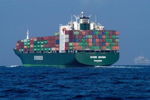
Global shipping routes crisscross the world’s oceans in
the research. this map of shipping lanes derived from a 2008 study of
1/3
the human impact on marine ecosystems. Maritime traffic the velocity of the ball and the time it takes to
 along these lanes is also a major source of noise       bounce back to your hand, then you can calculate
 pollution, which is increasingly considered harmful to  how far from the ground you are. The shape of the
 marine mammals. Credit: Grolltech
                                                        returning pulse can tell you something about the
                                                        features on the ground. A smooth target like the
                                                        ocean will bounce back an expected pulse shape,
                                                        but if something like an iceberg, island, or ship is
Tournadre said he hopes the new study will              present, the shape of the echo will change.
increase scientists' understanding of how human
activities are affecting marine ecosystems and          In 2007, Tournadre was poring over hordes of
improve models of atmospheric pollution in the          satellite data for signs of icebergs in polar seas,
open ocean.                                             when he noticed an odd shape in the data.

The new dataset will provide scientists with            "We had some unconventional data in a region, and
invaluable insights into the patterns of ship traffic   careful analysis showed us that it was a lighthouse
and the traffic's effect on the environment, said       near shipping lanes," he said. "As we processed
Batuhan Osmanoglu, a radar systems engineer at          the data over the whole globe, we also detected
NASA's Goddard Space Flight Center in Green             ships."
Belt, Md., who was not involved in the study.
                                                        Tournadre found that the altimetry data accurately
"The nice thing about this study is that they have a    reproduced known shipping lanes and could be
unique dataset, that maybe we're looking at for the     used to estimate the number of vessels on the
first time," he said. "Whenever you have a unique       ocean worldwide. The study used altimetry data
dataset you can quite easily learn something new."      from seven different satellites to map ship traffic
                                                        from 1992 to 2012.
The new study is the first to track ship traffic on a
global scale, Tournadre said. Currently, ship traffic   Using satellite data made it possible to calculate
is monitored using the Automatic Identification         ship traffic for the entire globe, whereas AIS
System (AIS). When vessels are near the coast,          records provide relatively limited coverage in both
they use transponders to send out their location        space and time, Tournadre said. The new method
information to other ships and base stations on         also allowed him to look back at two decades of
land. However, the AIS system doesn't work very         traffic using archived data, and give independent
well when ships are out on the open ocean.              measurements of ship traffic that were not based
Vessels are often out of range of terrestrial base      on the will or capability of ships to transmit their
stations or other ships, and few satellites carry the   own positions.
AIS instrumentation necessary to locate vessels
from space.                                             However, Tournadre also cautions that some of the
                                                        growth he has seen in ship traffic could be
The new method outlined in the study uses               overestimated because ships, especially container
altimeters, or instruments that measure altitude,       ships, have become larger over the past two
aboard satellites to detect the location of ships at    decades and possibly easier to detect with altimetry
sea, similar to the way these instruments have          data.
been used to track icebergs.
                                                          More information: "Anthropogenic pressure on
The altimeter sends a radar pulse down to Earth
                                                        the open ocean: the growth of ship traffic revealed
from the satellite and constructs an image of the
                                                        by altimeter data analysis"
surface based on the time it takes the pulse to
                                                        onlinelibrary.wiley.com/doi/10 …
bounce back to the instrument and the shape of the
                                                        014GL061786/abstract
pulse when it arrives. The method works similar to
throwing a ping pong ball at the ground: if you know

                                                                                                        2/3
Provided by American Geophysical Union
                                   APA citation: Worldwide ship traffic up 300 percent since 1992 (2014, November 17) retrieved 6
                                   December 2018 from https://phys.org/news/2014-11-worldwide-ship-traffic-percent.html

                                   This document is subject to copyright. Apart from any fair dealing for the purpose of private study or research, no
                                   part may be reproduced without the written permission. The content is provided for information purposes only.

                                                                                                                                                3/3

Powered by TCPDF (www.tcpdf.org)
You can also read