2020-2021 Plan Dakota County Cooperative Weed - PREPARED BY: Dakota County-SWCD
←
→
Page content transcription
If your browser does not render page correctly, please read the page content below
Dakota County Cooperative Weed
      Management Area

           2020-2021
              Plan

                 PREPARED BY :

                 Todd Matzke
     DAKOTA COUNTY AGRICULTURAL INSPECTOR
          RESOURCE CONSERVATIONIST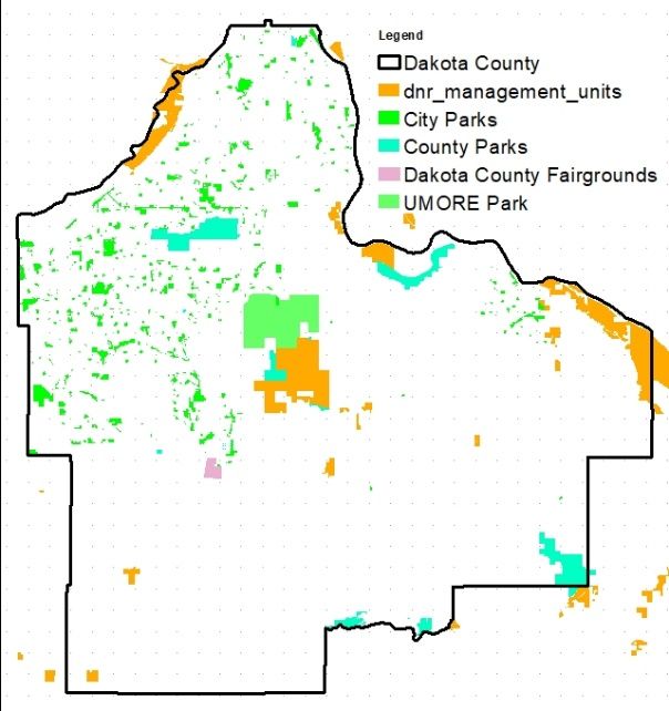
2020 – 2021 Dakota County Cooperative Weed Management Area Plan

Contents
Introduction                                                                                     4
Cooperative Weed Management Area Organization                                                    5
Geographic Area and Description                                                                  5
Cooperating Partners                                                                             7
Steering Committee                                                                               7
Mission                                                                                          7
Funding and Administration                                                                       8
Highest Priority and Weeds of Concern                                                            8
Objectives                                                                                       9
        Objective 1: Establishment of The Cooperative Weed Management Area                       9
        Objective 2: Adopt a baseline Collection Database                                        9
        Objective 3: CWMA partner weed identification workshop                                   10
        Objective 4: Inventory, mapping, and controls                                            10
        Objective 5: Share information among CWMA Partners and Cooperators                       11
        Objective 6: Restore impacted areas                                                      11
        Objective 7: Monitor control areas                                                       12
        Objective 8: Public Education and Outreach Program                                       12
        Objective 9: Seek Grant Funding                                                          13

Appendix
Abbreviations                                                                                    A1
Roster of Active CWMA participants                                                               A2
Cooperative Weed Management Area Memorandum of Understanding                                     A3
        Agreement (signatory) Document                                                           A4

Attachments
Attachment 1. Wild Parsnip Identification Course                         August 13, 2020
Wild parsnip Identification courses to be held outdoors at the City of Hampton – Fire Station and City
Hall. Course is intended for City and Township Officials.

                                                        2
2020 Version 1.0
Adopted: 08/06/2020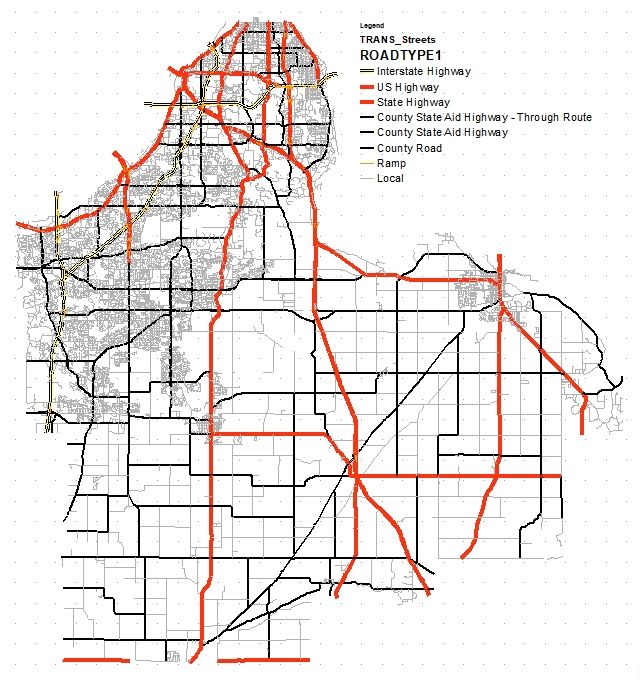
2020 – 2021 Dakota County Cooperative Weed Management Area Plan

                                      -This Page Intentionally left Blank-

                                                        3
2020 Version 1.0
Adopted: 08/06/2020
2020 – 2021 Dakota County Cooperative Weed Management Area Plan

Introduction
In 2017, Dakota County, Dakota County Cities and Township realized that Wild Parsnip, Spotted
Knapweed, Leafy Spurge and other noxious weeds were becoming more prevalent in road right of
ways, state and county controlled properties and railroad right of ways. Some plants are noxious
because they can harm people, animals the food we eat, and nature. Wild parsnip was spreading at
a rapid rate; first appearing in small patches in state right of ways and quickly spreading to county
and local roads. Efforts were started by individual Townships and by the Dakota County
Transportation Department to control wild parsnip. Actions, control methods, and weed
management resources varied from entity to entity. Noxious weeds spread and invade without regard
to borders and traditional control methods and were increasing the areas of infestations. Dakota
County determined that working as individual departments or municipalities was not as effective as
working together to create control plans and pool resources. Dakota County Soil and Water
Conservation District (SWCD) presented to the Township Officers and Dakota County
Transportation and Dakota County Parks Department the idea of developing a Cooperative Weed
Management Area.

A Cooperative Weed Management Area (CWMA) is a formal partnership developed between
Landowners, government agencies and organizations with the goal of managing invasive plants
across jurisdictional and landownership boundaries. The CWMA establishes a defined work area
where local units of government, state and federal agencies, and citizens can pool resources to
address invasive species problems held in common. CWMA’s established in similar counties in
Minnesota have found that these partnerships are more efficient and effective than piecemeal
approaches and have proven successful when partnerships were established for long term
commitments made by formal agreements.

Cooperative Weed Management Areas (CWMA) are not a new concept. State and County experts in
noxious weeds have helped private landowners for years. However, the scale of the problem was
often confined to an individual landowner instead of on a community, watershed or landscape
basis. For a variety of reasons one landowner often diligently combated noxious weeds while a
neighbor did not, which exacerbated the problem. Varying levels of interest, knowledge, skills,
resources and commitment were wasted while noxious weeds continued to expand.

With support from the Dakota County Transportation, Dakota County Parks Department and
Dakota County Township Officers Association, the Dakota County SWCD applied for grant funding
to form a Cooperative Weed Management Area (CWMA). The effort would be led by the SWCD and
would be guided by a steering committee.

                                                        4
2020 Version 1.0
Adopted: 08/06/2020
2020 – 2021 Dakota County Cooperative Weed Management Area Plan
Cooperative Weed Management Area (CWMA) Organization
With a grant funded from the Minnesota Board of Soil and Water Resources (Mn BWSR), the Dakota
County SWCD agreed to hold meetings to organize the Cooperative Weed management Area. A Steering
Committee was solicited by the SWCD to identify partners, seek input, and develop goals and strategies
for the CWMA. The Steering Committee was instrumental in determining the Geographic area of the
CWMA. All cities, townships, Dakota County, and Dakota County citizens would be encouraged to
participate in the CWMA. State and federal agencies, and Railroads Companies with a vested interest in
noxious weed control in Dakota County, would also be encouraged to participate in the CWMA. The
Dakota County SWCD, as one of the founding partners of the CWMA, would maintain a roster of
participating partners that have signed MOUs. The Dakota County SWCD would act to organize CWMA
meetings as determined by the Steering Committee. Sub committees would be established to create an
education and outreach program for the CWMA. The Steering committee determined that a formal
agreement between partners was needed to attain a wide array of stakeholders and landowners. The
formal agreement or Memorandum of Understanding (MOU) would be useful in developing the
organization and would aid in decision making and growth of the CWMA.
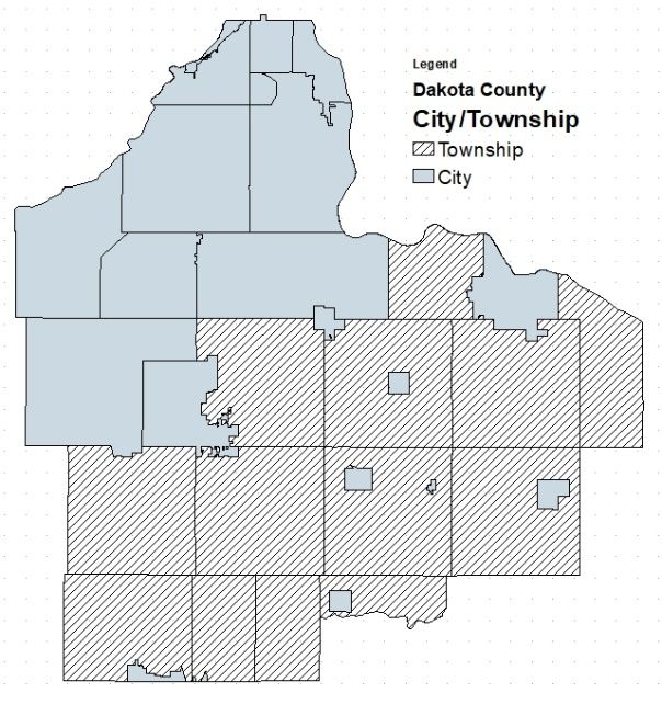
Geographic Boundaries and Description
Location: The Dakota County CWMA is geographically defined as the lands and waters within the
geopolitical boundaries of Dakota County, Minnesota. Dakota County is 587 square miles in area and is
situated in the southeast corner of the Twin Cities Metropolitan area and is the third-most populous
county in the state of Minnesota. In
2018, Dakota County, MN had a
population of 425,423 people with a
median age of 38.2 and a median
household income of $86,302.
Landscape: Dakota County is
organized with twenty-two Cities
and thirteen Townships and roughly
maintains a land use mixture of 1/3
urban, 1/3 suburban and 1/3 rural.
This combination of land use and
the confluence of two major rivers
(the Mississippi and Minnesota) that
form the county's northern and
eastern borders makes Dakota
County a unique geographic area.
5
2020 Version 1.0
Adopted: 08/06/20202020 – 2021 Dakota County Cooperative Weed Management Area Plan
Dakota County contains two park reserves,
three regional parks and one county park,
totaling more than 5000 acres and which
protect some of the county’s highest quality
natural resources. In addition, the Dakota
County park system is also developing a
growing network of regional greenways that
when complete will total nearly 200 miles of
trails and serve as ecological functioning
corridors when complete.
In Dakota County, The Minnesota Department
of Natural Resources (Mn DNR) manages 700
acres of Aquatic Management Areas (AMA), 720
Acres of Scientific and Natural Areas (SNA),
2000 acres of State Park, and 9127 acres of
Wildlife Management Areas (WMA).
Dakota County Transportation highway system is
made up of 320 miles of County State Aid
Highways (CSAH) and 104 miles of County roads
(CR). The overall County system consists of 424
centerline miles of which approximately 359 miles
(85 percent) are paved and 65 miles (15 percent)
have a gravel surface.
In Dakota County, the Minnesota Department
Transportation maintains a highway system made
of 74 miles of Interstate highway, 77 miles U S
highways and 175 mile of state highways.
Dakota County Townships and Cities maintain
2183 miles of roads
6
2020 Version 1.0
Adopted: 08/06/20202020 – 2021 Dakota County Cooperative Weed Management Area Plan
Cooperative Partners
The success of the Dakota County CWMA is dependent on the organization and participation of its
partners. All Cities, Townships, State and Federal Agencies, as well as Railroads Companies, will be
encouraged to participate in the CWMA as Partners or Cooperators. Participation in the CWMA is
voluntary and CWMA partners may withdraw from the partnership by providing a written statement to
the Steering Committee. Partner expectations are outlined in Section III of the Memorandum of
Understanding (MOU). The Dakota County SWCD agrees to gather and maintain a roster of participating
CWMA partners and cooperators. The roster shall be updated annually or upon notification in writing to
the CWMA by the partner or cooperator.
Steering Committee
Steering Committee members were solicited by the Dakota County Soil and Water Conservation District for
their expertise as well as to represent a geographic region. The Steering Committee consisted of partners
that had expressed the most interest in noxious weed control and forming a CWMA. Committee members
will serve on a voluntary basis. The Steering committee was chosen to represent the county as a whole. The
purpose of the Steering Committee was to determine the project area of the CWMA, determine the primary
and secondary weed species for control, establish a common database for entry of invasive and noxious
weeds problem sites, establish an education and outreach program to help local management teams identify
the primary and secondary invasive and noxious weed species, identify management techniques for control
and eradication of these species, provide direction for a Dakota County Volunteer program that will be
managed by Dakota County Parks -Natural Resources Department and ensure the implementation of the
strategic plan.
Partner Organization: Representative(s)
Burnsville Caleb Ashling
Mendota Heights Krista Spreiter
Inver Grove Heights Craig Reller
Castle Rock Township Sandra Weber
Hampton Township Jim Sipe
Dakota County – Facilities Maintenance Brad Deitner
Dakota County - Transportation Mike Greten
Greenvale Township Anthony Rowan
Mn Department of Natural Resources Russel Smith
Dakota County – Natural Resources Meghan Manhatten
Mn Department of Agriculture Christina Basch
Dakota County – SWCD Todd Matzke
Table 1: Dakota County CWMA Steering Committee
Mission
The mission of the Cooperative Weed Management Area (CWMA) is to enhance the success of the
noxious and invasive weed management for Dakota County by encouraging sharing of resources,
information and expertise.
7
2020 Version 1.0
Adopted: 08/06/20202020 – 2021 Dakota County Cooperative Weed Management Area Plan
Funding and Administration
Competitive grants will be the primary funding source of the Cooperative Weed Management Area. The
fiscal agent for each grant will be determined as grants are being considered based on requirement of
the grant. The Steering Committee will be responsible for reviewing and making recommendations on
program budget and identifying projects to be funded. Initial funding to establish the CWMA has been
provided for by a grant from the Minnesota Board of Water and Soil Resources. The fiscal agent of these
funds is the Dakota County Soil and Water Conservation District and will expire on December 31, 2020.
Highest Priority and Weeds of Concern
The Steering Committee has identified Wild Parsnip, Leafy Spurge, Spotted knapweed and Palmer
Amaranth as the highest priority species due to public concern and interest. Garlic Mustard, Narrowleaf
bittercress, Japanese hedge parsley, and Common or European Buckthorn were identified in the
northern half of Dakota County as a species of concern. The Steering Committee recognizes that there
may be other invasive noxious weeds within the boundaries of Dakota County. Species listed by the
Minnesota Noxious Weed list will be considered by the Steering Committee to update the priority and
weeds of concern list as these weeds become more prevalent or of higher concern.
Minnesota Department of Agriculture Noxious Weed list.
For a current list of noxious weeds, refer to Minnesota Department of Agriculture web site:
https://www.mda.state.mn.us/plants-insects/minnesota-noxious-weed-list
8
2020 Version 1.0
Adopted: 08/06/20202020 – 2021 Dakota County Cooperative Weed Management Area Plan
Cooperative Weed Management Area Objectives.
Objective 1. Development of the Cooperative Weed Management Area.
The CWMA recognizes that Dakota County is diverse with a unique mix of older developed communities,
newer urban communities, and rural townships, each with a different perspective of vegetation
management and invasive weed control. The CWMA realized that with this mix of partners there may be
different objectives and goals. Each will need to be taken into consideration when considering new
partners. However, the CWMA realizes that while this may create a challenge, this mix of partners can
also provide an opportunity of bringing in knowledge and techniques for invasive weed control that
would not necessarily be available if the CWMA was limited to one geographical area of the county.
Therefore, it was determined that all Cities and Townships would be encouraged to participate in the
CWMA. Any efforts to control noxious and invasive weeds would be missing a key partner unless state
and federally controlled lands were not also adapted to the CWMA.
The following definition shall be used to define a CWMA Partner: A Dakota County City or Township, a
local, state or federal government agency, a privately controlled business, or a not-for-profit
organization. A CWMA Partner is an entity that has signed a Memorandum of Understanding (MOU)and
agrees to participate in fulfilling the goals stated in Objectives 2 thru 9.
Various other organizations or individuals may choose to participate informally as Cooperators with the
CWMA. Cooperators may contribute in kind services or funds. A Cooperator must provide a plan of
activities to the CWMA Partner prior to any action. Finally, the CWMA recognized that railroad
companies were a significant property owner within Dakota County. Because railroad companies are
often controlled by managers that work from locations outside of the of the county and some are
located outside the state, participation would be difficult. However, the CWMA has decided an effort
should be made to contact railroads to participate. Railroad companies may become partners or
cooperators.
Actions
A. Develop a bi- annual Plan of Work.
B. Identify and contact new partners.
C. Identify and contact new cooperators.
D. Develop a formal agreement with new partners using a Memorandum of Understanding.
Objective 2. Adopt a Baseline Collection and Mapping System.
The Steering Committee determined that using a readily available system, developed for identifying and
mapping noxious weed rather than developing a new mapping inventory system would be the most
effective and efficient. Early Detection and Distribution Mapping System (EDDMapS) was recommended
by the Minnesota Department of Agriculture and was chosen by the Steering Committee for the initial
inventory of invasive and noxious weeds. EDDMapS is a web-based mapping system for documenting
invasive species distribution. This system was selected due to its speed, ease of use, and simplifies the
data entry process even for users without geographic information systems experience. Launched in 2005
by the Center for Invasive Species and Ecosystem Health at the University of Georgia, it was originally
designed as a tool for state exotic pest plant councils to develop more complete distribution data of
invasive species.
9
2020 Version 1.0
Adopted: 08/06/20202020 – 2021 Dakota County Cooperative Weed Management Area Plan
Actions
A. Present EDDMapS to new partners and Cooperators.
B. Provide EDDMapS instruction for mapping and Inventory.
C. Provide follow-up Instruction for the management of record points.
Objective 3. CWMA Partner Weed Identification Workshops.
Identifying wild parsnip and many of the weeds listed on the Minnesota Department of Agriculture –
Noxious Weed list was identified as a primary concern by the Steering Committee. A survey of city and
township officials indicated that many could not properly identify the weeds of concern and desired
training to identify the primary weeds during the various stages of growth. The survey also identified
training to help managers with timing and methods control of the various weeds.
Actions
A. Weed Identification Workshop (Aug 2020, Sept 2020, 2021 training to be determined)
Objective 4. Inventory, Mapping, and Control
The strength of the CWMA is partners working together across boundaries to cooperatively control
species. The inventory and mapping of priority species and weeds of concern will be the responsibility of
the partners and cooperators. The inventory of priority weeds and weeds of concern will allow the
CWMA to provide maps and coordinate a control plan with partners and cooperators.
The CWMA realized that completing the inventory of priority weeds and weeds of concern would not be
enough to control these species. A coordinated strategy and method to document control efforts would
also be needed. Invasive Species Management Tracking System (ISMTrack) was recommended by the
Minnesota Department of Agriculture as a software application that could be used to track many
invasive species management activities including: staffing, treatment method, travel time, volunteer or
crew hours, weather conditions, completion dates and other critical information.
ISMTrack is a cloud-based software system developed by the Minnesota Department of Agriculture,
University of Minnesota, University of Wisconsin-Extension, Minnesota Department of Natural
Resources and Minnesota Department of Transportation. ISMTrack was developed to help land
managers track invasive species management across sites and over time. ISMTrack is integrated with
EDDMapS. ISMTrack is being used on limited basis by Dakota County to track weed control projects in
Dakota County Parks and Dakota County Transportation Spray Crew activities. Data can be shared,
downloaded and analyzed to increase efficiency and improve invasive species management by a team
and across organizations. Using EDDMapS and ISMTrack databases. The CWMA partners or cooperators
will generate maps from EDDMapS that will be used for future control.
Actions
A. Upload historical bulk data from each city/township to facilitate data sharing over boundaries
B. Coordinate an inventory of priority weeds and weeds of concern using EDDMapS.
C. Present and Provide instruction for ISMTrack.
10
2020 Version 1.0
Adopted: 08/06/20202020 – 2021 Dakota County Cooperative Weed Management Area Plan
Objective 5. Share Information Among CWMA Partners and Cooperators
As partners inventory and in some instances start to control areas, the CWMA will have the ability to see
these efforts, and in 2021 and beyond, coordinate and focus weed eradication across municipal
boundaries. The CWMA will coordinate an overall management strategy.
Using the software tools EDDMapS and ISMTrack, partner organization will have access to inventories
and control data of neighboring townships, cities, county or state agencies. This information when
shared across boundaries will allow partners to coordinate and, in many instances, combine efforts to
control species. Contracts to mow or spray areas could be combined by two or more partners. The
benefit being to pool funds and tap into technical expertise, knowledge, and control techniques. Shared
contracts between entities will also be a function of the CWMA to facilitate lower costs and increase
ease of invasive species management. The CWMA or groups of partners may create group contracts or
utilize existing county or state contracts to perform work in a more efficient and cost-effective manner.
Action
A. CWMA to coordinate and develop shared management strategies
B. CWMA to coordinate group contracts
C. CWMA to coordinate equipment
Objective 6. Restore Impacted Areas
The removal of vegetation often leaves a void in the landscape. These voids created by removing
noxious weeds and invasive species is often forgotten when creating a control program. Managers often
rely on the surrounding vegetation to provide a seed source or the rhizomes of roots to fill in those
voids. When the areas are small, such as those created by spot application of herbicide this technique
works relatively well.
Where the invasive species infestations have overwhelmed large areas, chemical application or
mechanical control will create large areas barren of vegetation. A restoration plan will need to be
incorporated into the control plan to prevent the re-infestation of unwanted plants.
Prior to European settlement, Dakota County was a mix of hardwood forests and vast areas of native
prairies. The CWMA understands it is unrealistic to restore all areas of the county to pre-settlement
condition. Managers are encouraged to research the conditions that existed prior to European
settlement and devise restoration plans that would mimic pre-settlement conditions. When the site
conditions are not feasible, managers should select species that will fill the void left by chemical or
mechanical vegetation control with species that will outcompete invasive or noxious weeds.
Action
A. Conduct site restoration workshops as part of Weed Identification Workshops.
11
2020 Version 1.0
Adopted: 08/06/20202020 – 2021 Dakota County Cooperative Weed Management Area Plan
Objective 7. Monitor Control Area
Invasive and noxious weeds grow aggressively, multiply quickly without natural controls and often show
adverse effects to people through contact or ingestion. Sites that have been documented and have been
treated will need to be revisited to evaluate the effectiveness of control. Often these sites will require
multiple visits over several years and require multiple control treatments to eradicate a troublesome
species. Annual actions would include revisiting areas to monitor for the effectiveness of the previous
control and possibly treat the area or schedule the area for future treatment. Both the EDDMapS and
ISMTrack software allow the user to go back to previously reported areas and document the area visit.
Simple training to use the software apps will be accomplished during weed identification workshop.
Action:
A. Review site maps and schedule follow up visits
B. Provide EDDMapS training for area re-visits
Objective 8. Public Education and Outreach.
Private citizens will be encouraged to work with Dakota County Cooperative Weed Management Area
partners to report and inventory weed infestations. Dakota County Parks has a robust volunteer
program and will, as needed, host volunteer registration and time tracking for practices for partner who
do not have volunteer engagement infrastructure in place. Volunteers would be recruited through
public outreach such as newsletters, public notices in newspapers, social media websites, signage in
populated public areas and word of mouth.
The CWMA recognizes that many private citizens will not have the skills or knowledge to identify the
priority weeds or most of the noxious weed listed by the Minnesota Department of Agriculture.
Therefore, weed identification education courses will need to be conducted. In addition, new
infestations will need to be recorded. Private citizens would be instructed how to use the EDDMapS
software application on their personal cell phone or tablets. Dakota County Parks will open their early
detection workshops to any CWMA volunteer, regardless of where they plan to survey. They will share
training slideshows and handouts with CWMA partners who wish to use them.
Action
A. Conduct species identification and EDDMapS workshops.
B. Develop resources for continued education and outreach
C. Coordinate training scheduling with Dakota County Parks
12
2020 Version 1.0
Adopted: 08/06/20202020 – 2021 Dakota County Cooperative Weed Management Area Plan
Objective 9. Seek Grant Funding
The CWMA recognizes controlling noxious and invasive species can be time consuming and costly. Wild
parsnip has been spreading rapidly across Dakota County. Many of the townships and cities have
indicated that maintenance budgets would not be able to cover the additional costs of controlling and
containing wild parsnip and have the funds for usual annual expenses. Additional funding sources will
need to be acquired through county, state and federal grants as they become available. Administration
of the grant will be determined by the type and terms of grants. Only active CWMA partners may be
eligible for grant funding.
As grants become available, sub committees will be formed to write grant applications and solicit state,
county and federal partners. With majority approval of the active CWMA partners, these grants will be
submitted on behalf of the CWMA.
For the fiscal year 2020, The Minnesota Department of Agriculture (MDA) has awarded $537,000 to
combat noxious weeds across Minnesota. Thirty-five projects were funded though the 2020 Noxious
Weed and Invasive Plant Grant.
The MDA anticipates another $100,000 will be available through the Noxious and Invasive Plant Grant
for the next fiscal year (FY21: July 1, 2020 – June 30, 2021). The Request for Proposals (RFP) will be
released by September 2020 and grants will be awarded in 2021.
MDA Grants funds were awarded at two levels for Fiscal Year 2020 (FY20). Level 1 projects were
awarded up to $10,000 each to be spent in one year to support local activity. Level 2 projects were
awarded between $10,000 and $50,000 each to be spent over two years to promote collaboration with
entities within and outside their jurisdictions.
Actions
A. Apply for grant funding
B. Determine fiscal agent
13
2020 Version 1.0
Adopted: 08/06/2020Appendix
Abbreviations
• AMA Aquatic Management Area
• CSAH County State Aid Highway
• CR County Road
• CWMA Cooperative Weed Management Area
• EDDMapS Early Detection and Distribution Mapping System
• ISMTrack Invasive Species Management Tracking System
• MDA Minnesota Department of Agriculture
• MN BWSR Minnesota Board of Water and Soil Resources
• MN DNR Minnesota Department Natural Resources
• SNA Scientific and Natural Area
• SWCD Soil and Water Conservation District
• WMA Wildlife Management Area
14
2020 Version 1.0
Adopted: 08/06/2020Roster of Active CWMA Participants
1. Dakota County Soil and Water Conservation District Todd Matzke
todd.matzke@co.dakota.mn.us 651)480-7780
2. Ravenna Township Caroline Spurgeon
clerk@ravennatownshipmn.com 651)480-1502
3. Castle Rock Township Sandra Weber
sandra@CrUSAdermfg.com 651)463-4725
4. Mendota Heights Krista Spreiter
kristas@mendota-heights.com 651)255-1123
5. Eureka Township Donovan Palmquist
dpalmquist@eurekatownship-mn.us 952)469-3736
15
2020 Version 1.0
Adopted: 08/06/2020You can also read