DISTRIBUTION OF SUBSURFACE SEDIMENTATION AS A POTENTIAL MINERAL PLACER DEPOSITS IN SOUTH BINTAN ISLAND WATERS
←
→
Page content transcription
If your browser does not render page correctly, please read the page content below
Bulletin of the Marine Geology, Vol. 36, No. 1, June 2021, pp. 15 to 26

DISTRIBUTION OF SUBSURFACE SEDIMENTATION AS A
POTENTIAL MINERAL PLACER DEPOSITS IN SOUTH BINTAN
ISLAND WATERS

SEBARAN SEDIMENTASI BAWAH PERMUKAAN SEBAGAI
POTENSI ENDAPAN MINERAL PLACER DI PERAIRAN SELATAN
PULAU BINTAN

Muhammad Zulfikar1,2, Nazar Nurdin2, Noor Cahyo Dwi Ariyanto2, Ildrem Syafri3, Budi Mulyana3,
Andi Agus Nur3
1Study Program of Master, Faculty of Geological Engineering, Padjadjaran University

 Jl. Raya Jatinangor Km. 21 Bandung, Indonesia
2Marine Geological Institute of Indonesia

 Jl. Dr. Djunjunan No.236 Bandung, Indonesia
3Faculty of Geological Engineering, Padjadjaran University

 Jl. Raya Jatinangor Km. 21 Bandung, Indonesia
Corresponding author: muhammad20389@mail.unpad.ac.id; muhammad.zulfikar@esdm.go.id
(Received 7 June 2021; in revised from 18 June 2021; accepted 26 July 2021)

                 AB S T RACT : Bintan Island is one of the areas traversed by the Southeast Asian granitoid belt which is
                 known to have the potential for heavy mineral placer deposits. Due to the dwindling presence of heavy
                 mineral placer deposits in land areas, it is necessary to explore in water areas. Delineation of deposits
                 accommodation of heavy mineral placer in the defined area are requires subsurface imaging investigations.
                 The method used in this subsurface mapping is a single channel seismic method with a total of 179 lines from
                 northeast-southwest and west - east directions. The results of this seismic record are then interpreted as the
                 boundaries of the seismic facies unit and distributed using the kriging method. Furthermore, the thickness
                 calculates by using the assumption velocity of 1600 m/s.
                 Based on the facies unit boundaries that have been interpreted, the quaternary sediments that formed in the
                 study area are divided into 2 types of units, namely: Unit 2 which is estimated to be fluvial - transitional
                 sediment, and Unit 1 which is estimated to be transitional - shallow marine sediment. There is also a
                 difference in thickness patterns in these two units, where Unit 2 shows a pattern of sediment thickening that
                 resembles a paleochannel trending northeast - southwest, while Unit 1 is relatively uniform.
                 From the results of this study, it can be said that the area that has potential of heavy mineral placer deposits is
                 in the west-center of the southern waters of Bintan Island. Where the potential for heavy mineral placer
                 deposits should be in the paleochannel deposits that are part of Unit 2.
                 Keywords: Quaternary Sediments, Heavy Mineral Placer Deposits, Rare Earth Elements, Southern
                           Waters of Bintan

                 A B ST R A K : Pulau Bintan merupakan salah satu wilayah yang dilalui oleh jalur granitoid Asia Tenggara
                 yang dikenal memiliki potensi keterdapatan mineral berat plaser. Akibat keberadaan mineral berat plaser di
                 wilayah daratan semakin menipis, maka dilakukan pencarian potensi tersebut di wilayah perairan.
                 Delineasi wadah mineral berat plaser pada area ini memerlukan penyelidikan citra bawah permukaan.
                 Pemetaan bawah permukaan ini menggunakan metode seismik single channel dengan jumlah lintasan
                 sebanyak 179 lintasan dari timurlaut - baratdaya dan barat - timur. Hasil rekaman seismik ini kemudian
                 diinterpretasi batas-batas unit fasiesnya dan disebar dengan menggunakan metode kriging. Selanjutnya
                 dihitung ketebalannya dengan menggunakan asumsi cepat rambat 1600 m/s.
                 Berdasarkan batas unit fasies yang telah diinterpretasi sedimen kuarter yang terbentuk di daerah penelitian
                 terbagi menjadi 2 jenis unit yaitu: Unit 2 yang diperkirakan merupakan sedimen fluvial - transisi, dan Unit
                 1 yang diperkirakan sebagai sedimen transisi - laut dangkal. Terlihat pula adanya perbedaan pola
                 ketebalan sedimen pada kedua Unit ini, dimana Unit 2 menunjukkan adanya pola penebalan sedimen
                 menyerupai paleochannel berarah timurlaut - baratdaya sedangkan pada Unit 1 relatif terlihat seragam.

                                                                                                                                 15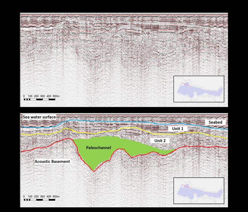
Dari hasil penelitian ini dapat disimpulkan bahwa daerah yang memiliki potensi endapan mineral berat
                plaser berada di Barat ke tengah daerah perairan selatan Pulau Bintan. Dimana potensi endapan pembawa
                mineral berat plaser seharusnya berada pada endapan paleochannel yang merupakan bagian dari Unit 2.
                Kata Kunci: Sedimen Kuarter, Endapan Mineral Berat Plaser, Unsur Tanah Jarang, Perairan Selatan
                            Bintan

INTRODUCTION                                                     based on subsurface sedimentary pattern by using single-
      Southeast Asia is one of the areas traversed by the        channel seismic data interpretation. Data analysis was
granitoid route that carries economically heavy minerals.        performed by identifying reflector configuration patterns
Where this granitoid line stretches for 3000 km from             and those continuity. Where sediment units that are
Burma to West Kalimantan, not passing through Bintan             estimated to have the potential for placer mineral deposits
Island and the surrounding waters (Cobbing, 2005). As it         are generally sediment units located just above the
                                                                 acoustic basement (granite??) or unit 2 with a paleovalley
is known that the distribution of these granitoids is not
                                                                 or paleochannel shape. These characterizes (paleovalley/
only on land, but also spreads to the waters (Zulfikar et al.,
                                                                 paleochannel) showed alluvial deposits and generally has
2020). The presence of placer-heavy minerals on land
                                                                 potential to contain placer minerals (Arifin, 2011; Raharjo,
through which the Southeast Asian granitoid route passes
                                                                 2007).
is limited. This forces geological explorers to look for new          The study area is located in the southern waters of
reserves in territorial waters. The mineral placer deposits      Bintan Island, part of East Bintan District, Bintan
exploration is intrinsically linked with the mineral deposit     Regency, Riau Islands Province. It lies within the latitude
accommodation. We need to find this heavy minerals               86,874.34 mN to 93,664.28 mN and the longitude
placer deposit accomodation that contain fairly large            441,499.37 mE to 456,751.02 mE (Figure 1).
mineral placer accumulation.                                     Geographically, it is part of northern hemisphere UTM
      The objectives of this study are to investigate the        Zone 48 N.
presence of accommodation of heavy mineral and rare
earth elements deposits in South Bintan Island Waters

 Figure 1. Study area

16   Muhammad Zulfikar, et al.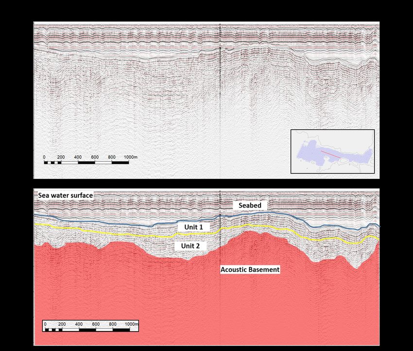
Geology of Bintan Island and its surroundings               the Goungon Formation is deposited which dominates
      According to Kusnama (1994) Bintan Island and its           almost all parts of the mainland of Bintan Island. The
surroundings are part of the Riau Archipelago which is            Goungon Formation is composed of white tuffaceous
generally composed of intrusive igneous rocks in the form         sandstone, fine to medium grained, has a parallel
of granite and diorite of pre-tertiary (Triassic) age. This       laminated structure. In addition, there are also siltstones
breakthrough rock is the oldest rock on the mainland of           and dacitan tuff and feldspathic lithic tuff, smooth, white
Bintan Island with enough to dominate about 40% of the            in color and locally interspersed with tuffaceous
total land on Bintan Island (Figure 2).                           sandstones. This formation was deposited in a fluviatile
      In a small part in the southwest part of Bintan Island,     environment and is Pliocene - Pleistocene in age. Then

 Figure 2. Geological rock formation (Kusnama, 1994) and seismic lines map

sedimentary rocks of Cretaceous age were found, namely            above the Goungon Formation, alluvium of Holocene age
the Pancur Formation and the Semarung Formation. The              was deposited which was composed of sand, yellowish red
Pancur Formation is composed of claystone/shale with a            with a composition of quartz, feldspar, hornblende and
reddish color with a pencil structure, in some places there       biotite which is a remnant of granite erosion. This
are inserts of well-layered and well-separated quartz             alluvium unit is the result of river and coastal deposits that
sandstone. This formation is not aligned with the granite         cover unconformably above the Goungon Formation or
rock which is thought to be the acoustic bedrock in the           older rocks. All rock formations in the study area are
Bintan Island area. Meanwhile, the Semarung Formation             shown in the regional stratigraphic table (Figure 3).
is composed of medium-coarse grained arcose sandstones,                 Quaternary Sediments of Bintan Island and its
well consolidated and there are claystone inserts with light      surroundings
gray color and thin layers. The Semarung Formation was                  At the age of the quarter around 12,000 - 15,000
deposited in a terrestrial environment until the transition       years ago during the Last Glacial Maximum (LGM),
which also overlaps with the Pancur Formation.                    Bintan Island was still part of the Sunda Shelf which
     Above the Triassic-aged granite, andesite rocks are          stretched from China to Madura Island and East
formed with the composition of plagioclase, hornblende,           Kalimantan. At that time, the waters of Bintan Island and
and biotite. This rock has a porphyritic texture with a base      its surroundings were still in the form of land, around
mass of micro-crystalline feldspar and is generally fresh         which many ancient river patterns developed that flowed
rock. This andesite rock is estimated to be in the Early          into the South China Sea (Hanebuth et al., 2002;
Miocene to Late Miocene age. Above these andesite rocks           Molengraaff & Weber, 1921; Pucha?a et al., 2011;

                                                                                         Bulletin of the Marine Geology 17
                                                                                                Vol. 36, No. 1, June 2021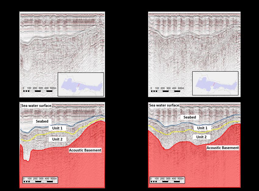
Figure 3. Regional stratigraphy of Bintan Island and surroundings (Kusnama, 1994)

Sathiamurthy & Rahman, 2017; Solihuddin, 2014; Voris,             Island are I-type granitoids. Genetically, Winter (2001)
2000).                                                            considers that this I-type granite is a granite that formed by
      Pre-quaternary rocks that located on Bintan Island          partial melting of mafic mantle igneous material from
and its surroundings are dominated by Triassic-aged               subduction zones which results in the formation of
granite. This granite rock is thought to be a large batholith     breakthrough rock with a distinctive chemical
body. In some places, the body of this batholith were             composition.
intruded again by andesite at the Oligocene - Miocene age.              Previous research stated that the I-type granitoids
All of these rocks then undergo a weathering process and          have heavy mineral potential such as Cu and Mo, which
were eroded by the drainage system or the evolving fluvial        were formed from volcanic arc granite (Pearce et al.,
system. Thus, all of the eroded materials were transported        1984). Moreover, Setiady and Sarmili (2005) stated that
and deposited. The sedimentary materials that transported         seabed sediments and coastal sediments in the waters
from the previous rock were accumulate in deposit trap            around Batam Island and the western part of Bintan Island
(valley). These area have a relatively low morphology             contain various metallic minerals. These heavy minerals
compared to the source rock. This process continues until         are magnetite, ilmenite, monazite, cassiterite, hematite,
the Last Glacial Maximum occurs and causes global land            etc. This is allegedly due to the deposition of placer
sinking by sea level rise.                                        minerals resulting from the breakdown of granite rocks on
      The sinking that occurred during the Last Glacial           Batam Island and Bintan Island.
Maximum caused sea levels rise to covered fluvial                       In addition, as is well known, most of Bintan Island is
depositional patterns. The sea level which was originally         rich in bauxite content. Where this bauxite is found in clay
under 120 meters from the sea level today, tends to rise          from weathered granite with a high alumina content
until the depositional environment which was originally a         (Rohmana et al., 2007; Yusuf et al., 2005). The formation
terrestrial environment turns into a marine environment.          of bauxite is due to very intense weathering, causing the
This includes the southern waters of Bintan Island and its        lateritized zone of granite to be enriched by bauxite and
surroundings. Terrestrial depositional facies, which were         deposited above the source rock. Even in the northern and
originally rocks older than the quarter, were later covered       eastern parts of Bintan Island, a rock structure in the form
by transitional and marine facies.                                of Corestone is formed which is a sign of fairly massive
      Heavy Minerals and Rare Earth Elements                      granite weathering (Hutabarat et al., 2016).
Potential on Bintan Island                                              In addition to the potential for heavy minerals,
      The entire area that traversed by Southeast Asian           Bintan Island also has a high potential for rare earth
granitoid belt has potential for presence heavy mineral           elements. Irzon and Abidin (2017) mention that granite
placer deposits. These deposits were formed from                  rocks in the north of Bintan Island have a high content of
fragments of granitoid rocks that carry heavy minerals.           rare earth elements. Where regionally, Kusnama (1994)
Cobbing (2005) classifies that the Granitoids in Bintan           stated that, the granite in the north of Bintan Island has

18   Muhammad Zulfikar, et al.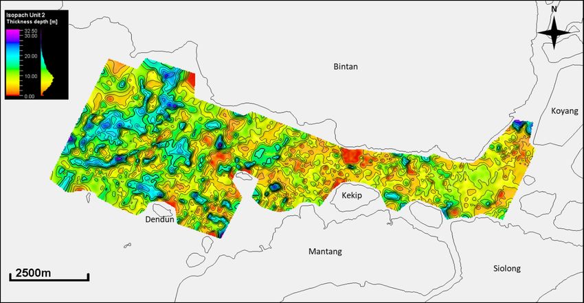
similarities with the granite in the south of Bintan Island. distribution of these horizons. Furthermore, to determine
The identification of placer mineral deposits using a the distribution of sediment unit thickness in meters
seismic stratigraphic interpretation approach in the waters (isopach), we used a time to depth conversion with a
will provide clues to the drilling target and delineation of velocity assumption around 1540 m/s for seabed (water
the boundary of the placer mineral deposits (Batchelor, velocities) and 1600 m/s for subsurface sediment
1979). Batchelor's succeeded in exploring placer minerals (Puchala, 2011) . The whole processing and interpretation
(in this case offshore tin), with the concept that the was performed by Sonarwiz and Petrel software.
potential of placer minerals deposits is not only in young
alluvium valleys (which are the result of onshore source RESULTS
rock deposits). But it is also located in the old sedimentary Total of 179 seismic lines that have been interpreted
facies which is a subsurface heavy mineral-bearing rock in this study area. The track consists of a main line with a
deposit. These event occurred before the last glacial northeast - southwest direction, and a crossline with a west
maximum period, when Sundaland still exist. So the - east direction. Based on the reflector configuration
thickness stratigraphic unit distribution becomes analysis from the seismic records, there are 3 seismic
important. horizons that bounded 2 seismic facies units above the
acoustic basement with various thickness patterns and
METHODS markedly different distribution patterns. These 3 horizons
The subsurface geological conditions in this study are presumed to be quaternary sediments consists of the
were identified using shallow reflected seismic. The total seabed (horizon 1), bottom unit 1 (horizon 2) and acoustic
number of lines acquired as a result of 179 routes basement (horizon 3).
stretching from the western waters of the south of Bintan Seismic Correlation Surface and Seismic Facies
Island and the east of the southern waters of Bintan Island, Unit
while the northern and southern parts of the research area Seismic Correlation Surface
are located in the strait between the south of Bintan Island The interpretation of the three horizons then
and the north of Mantang Island. The intervals between correlated as a surface, which were distribute throughout
lines are range from 100 - 200 m with the main line the entire area. The result of this seismic horizon
direction relative to the northeast - southwest as many as interpretation shows the paleogeographic pattern in the
135 lines and a cross-section with a west - east direction as area. Each horizon has a difference pattern, horizon 3
many as 44 lines. The length of each track ranges from 150 shows a depth pattern that is relatively different from the
meters - 4400 meters. recent bathymetry. This surface shows the steep highs
Single-channel seismic reflection using a typical countours and the other place shows a continuous valley.
single plate boomer sound source with a total power of 300 Meanwhile, horizon 2 does not show a significant
joules to produce sound waves at every 0.5 seconds of shot difference in depth pattern from horizon 1 which is the
interval. Such waves propagate towards the seabed and are current bathymetry.
reflected back to the streamer hydrophone. Parameter of Seismic Facies Unit
these wave propagation contains information about the Based on the results of the correlation between the
properties of the subsurface. Seismic recording executed surface area boundaries, the study area is divided into 3
by using Sonarwiz 5 software with the ouput of digital data seismic facies units, namely:
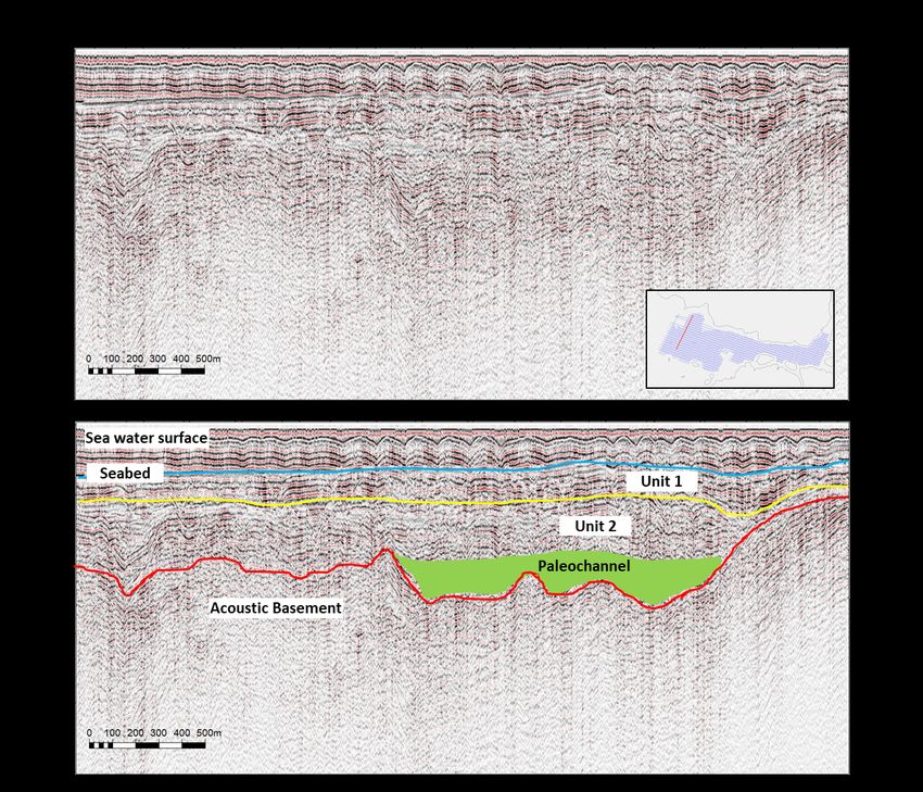
recorded in the SEG-Y format (filename extension .sgy) Facies Unit 3 / Acoustic Basement
The data outputting from seismic acquisition has This facies unit is the oldest facies in the study area.
been further processed to enhance the quality of seismic Top of this unit overlain by the surface of bottom unit 2 and
images by denoising technique using band-pass filtering. the bottom boundary of these unit appear clear despite the
These band pass filtering processes was settings with used of maximum penetration during seismic acquisition.
following frequency limitation: low cut frequency 20 Hz, The reflector characteristics in the entire seismic
low pass frequency 750 Hz, high cut frequency 150 Hz and records of this unit shows a weak frequency, subparallel -
high pass frequency 1500 Hz. All of these processed are chaotic, and moderate amplitude. Based on the reflector
used over a range of 256 samples. To sharpen the pattern, this unit can be divided into 2 types, namely
resolution of the seismic image we used a gain setting of acoustic basement which is estimated as bedrock
3x10⁻⁴ dB. (granitoid?) and sedimentary rock. Acoustic basement is
From there on, we did the interpretation of generally dominates the whole area characterized by
sedimentary unit boundaries (horizon) based on chaotic and hyperbolic reflector patterns (Figures 4 and 5).
characteristics of seismic facies that derived from reflector Meanwhile, facies unit 3 which is a sedimentary rock
configuration of seismic profile (Mitchum, et al., 1977 in appears relatively subparallel - chaotic reflector pattern.
Veeken, 2007). After that, we created an isopach map that The thickness range of this facies unit cannot be identified
illustrates the stratigraphic thickness pattern between an because the lower boundaries of this unit cannot be known.
upper and lower horizon. We consider kriging as a fitted
geostatistical method to be used in predicting spatial
Bulletin of the Marine Geology 19
Vol. 36, No. 1, June 2021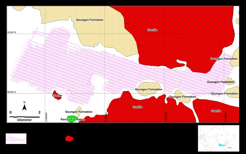
records of this unit
                                                                                           shows a moderate
                                                                                           frequency, subparallel
                                                                                           - chaotic, and medium
                                                                                           amplitude.       It     is
                                                                                           estimated that the
                                                                                           sediment deposited is
                                                                                           a       medium-coarse
                                                                                           fraction       sediment
                                                                                           resulting from the
                                                                                           previous            rocks
                                                                                           weathering        whose
                                                                                           transportation process
                                                                                           is not too far from the
                                                                                           source rock. In some
                                                                                           places,      continuous
                                                                                           valley that forming a
                                                                                           paleochannel         were
                                                                                           also found (Figures 6
                                                                                           and        7).        The
                                                                                           depositional pattern
                                                                                           that developed in this
                                                                                           unit is thought to be a
                                                                                           fluvial - transitional
                                                                                           depositional facies.
                                                                                           The thickness range of
                                                                                           this facies unit is quite
     Figure 4. Interpretation of seismic line XB_030
                                                                                           high, ranging from
                                                                                           0.75 - 30 meters.

      Facies Unit 2
      This facies unit
is a sedimentary
facies whose top is
bounded by the
surface of the bottom
unit 1/top unit 2
(horizon 2) and the
bottom is bounded by
surface of bottom
unit 2/top unit 3
(horizon 3) which is
presumably
sedimentary rock. In
some places there are
directly adjacent to
the           acoustic
basement           with
reflector patterns in
the form of chaotic
and          relatively
hyperbolic      shapes
sticking up like
granitoids.
      The reflector
characteristics in the
entire         seismic          Figure 5. LB_084 and LB_077 seismic lines interpretation

20      Muhammad Zulfikar, et al.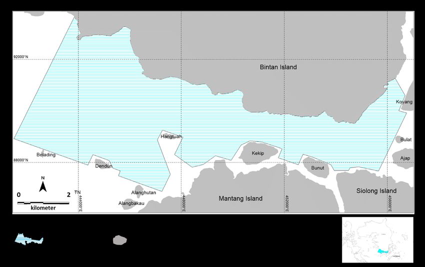
by tides and waves
                                                                                         and has not been well
                                                                                         compacted.
                                                                                               The sediments
                                                                                         in this unit are
                                                                                         estimated to be
                                                                                         dominated by fine
                                                                                         fraction sediments
                                                                                         and in some places
                                                                                         there     are     also
                                                                                         sediments dominated
                                                                                         by shell fragments
                                                                                         (Nurdin et al., 2020).
                                                                                         This is due to the
                                                                                         good lighting and
                                                                                         nutrition of the
                                                                                         environment,
                                                                                         making it a good
                                                                                         place for molluscs
                                                                                         and coral reefs to
                                                                                         grow. In addition,
                                                                                         this also shows that
                                                                                         the      depositional
                                                                                         environment in the
                                                                                         area is dominated by
                                                                                         tides and waves
                                                                                         where             this
 Figure 6. LB_128 seismic line interpretation                                            environment is in a

       Facies Unit 1
       This facies unit
is the youngest facies
unit      or      recent
sedimentary facies
which is bounded at
the top by the seabed
and at the bottom by
the bottom unit 1/top
unit 2.
       This unit has the
characteristics       of
high frequency, the
dominant reflector
pattern is simple
parallel continuous
with a small part
there is subparallel,
and the amplitude is
medium - high. This
is allegedly due to the
sediment deposited at
this time is sediment
resulting from the
deposition      of     a
shallow          marine
environment which
tends to be influenced
                           Figure 7. XB_025 seismic line interpretation

                                                                          Bulletin of the Marine Geology 21
                                                                               Vol. 36, No. 1, June 2021
coral reefs do not like places where the water is cloudy, The farther from the mainland, the thickness pattern is
which is a dominant feature of fluvial deposition. The relatively uniform. While there is also sediment thinning
thickness range of this unit ranges from 1 - 13.5 meters. up to 2 meters, this is allegedly due to the acoustic
basement in the area being closer to the surface. However,
DISCUSSIONS the sediment in central to eastern study area more thinner
Sediment Distribution Pattern in the Southern than central to western study area. This can be seen from
Waters of Bintan Island the influence of rock resistance to weathering. So that the
The distribution of quaternary sediments in the fluvial sedimentation that is formed is not well developed.
Southern Waters of Bintan Island shows patterns of In regionally, Kusnama (1994) provides a formation
thinning and thickening of sediments in unit 1 and unit 2. boundary in the south of Bintan Island between the west
However, the tendency of sediment thickening or thinning and the east. The western part is dominated by the
in unit 1 and unit 2 is different. This is because the Goungon Formation (Qtg), while the eastern part is
depositional facies in each unit are different, so the dominated by Triassic-aged granite (Trg).
depositional patterns are different. Overall, the thickness pattern in unit 2 shows a
Quaternary sediments Unit 2 relatively diverse sediment thickness. Where in the central
Unit 2, which is estimated to be a fluvial-transitional - western part of the study area, thickening of the sediment
depositional facies unit, shows a varied thickness pattern is seen with patterns resembling paleochannels which are
with a wide range ranging from 0.75 - 30 meters (Figure closely related to fluvial deposits. Meanwhile, in the
8). If we look at the pattern of unit 2 sediment thickness center - east study area sediment depletion is seen. Which
formed in the study area, there are differences in the is estimated to be in this area a relatively high level that is
pattern between the west - center of the study area and the still resistant to weathering. This indicates the unit of this
east - center of the study area. part is terrestrial depositional system. Where the terrestrial
Figure 8. Unit 2 isopach map
In the central to western part of the study area,
sediment thickening occurs with a pattern resembling a depositional system allows the formation of paleochannel
paleochannel. The sediments formed were relatively patterns.
thickened towards southwest of the study area. This According to Voris (2000), in the period before last
paleochannel is thought to be a fluvial deposit-forming glacial maximum, there were 4 large rivers formed in
groove which then continues to the larger main river. Southeast Asia, namely the North Sunda River, Siam
In the central to eastern part of the study area, the River, Malaca River and South Sunda River. Sediments
dominant sediment thickness pattern ranges from 3 - 7.5 originating from these large rivers flow from the highlands
meters. In some places close to the mainland, there is a and then head towards the open sea. The presence of
thickening of up to 20 meters, this is allegedly due to the paleochannels seen in the study area is estimated to lead to
influence of sedimentation from rivers on the mainland. one of the two major rivers, namely the North Sunda River
22 Muhammad Zulfikar, et al.or the Siam River. Judging from its geographical location, pattern. In addition, there is also sediment depletion up to 1
this paleochannel tends to join the North Sunda River to meter. This is presumably due to the reduced
the South China Sea. accommodation space caused by the basement acoustics
Quaternary Sediment Unit 1 getting closer to the surface. This pattern is relatively
This unit is interpreted as a transitional - marine similar to the thickness pattern in Unit 2. Where the
facies unit. It has simple parallel - subparallel reflector sediment tends to follow the shape of its accommodation
patterns which show a non-varied thickness pattern with a space (same as its Unit 2).
shorter range that ranging from 1 - 13.5 meters (Figure 9). Overall, the thickness pattern in unit 1 shows a fairly
The thickness pattern in this Unit 1 sediment shows a wide spread of sediment. It is shows these unit is a part of
different pattern in the middle - east part of the study area shallow marine depositional system (same as the current
compared to the western part of the study area. environmental conditions). Where this shallow marine
Figure 9. Unit 1 isopach map
The pattern of sediment thickness in the middle - deposition system is dominated by tides and waves.
west of the study area shows a dominant thickness with The Potential of Heavy Mineral Placer Deposits
range between 4 - 8 meters. However, in west and central or Rare Earth Elements in the Southern Waters of
part there are close to the main river in Bintan Island or Bintan Island
Mantang Island has a sediment thickening pattern up to 12 Based on consideration of sediment thickness and
meters. This is allegedly due to the influence of paleochannel pattern in Unit 2, which develops in a
sedimentation from the rivers. The farther from these river northeast-southwest direction with acoustic basement that
has a uniform thickness pattern. On the other hand there is shallow to the surface. The area that has greater potential is
also sediment depletion up to 3 meters. This is allegedly in central to west area. Where in this area Unit 2 has
due to the basement acoustics in the area closer to the paleochannel as a mineral placer deposit accommodation,
surface. Thus, the accommodation space for the sediment even more location of the source rock (acoustic basement)
is getting shallower. not too far away from the deposits. Regarding the type and
Meanwhile, in the central - eastern part of the study amount of mineral content, further research is needed
area has a thinner pattern than central - west study area using drill data and laboratory analysis.
with dominant pattern of sediment thickness ranges from 3
- 6 meters. However, in some places that are close to river ACKNOWLEDGEMENTS
in mainland showing the same pattern as the mid-west We would like to thank the Head of Marine
area. It can be seen from a thickening up to 12 meters. We Geological Institute and all the team members who
interpreted there cause of the sedimentation from the main involved during data acquisition, as well as those who
rivers on the mainland affects the sedimentation pattern. contributed to the success of this research program.
The farther from the mainland, shows a uniform thickness
Bulletin of the Marine Geology 23
Vol. 36, No. 1, June 2021CONCLUSION Kelautan, Bandung, Badan Penelitian dan
• Quaternary sediment deposits in the Southern Waters Pengembangan Energi dan Sumberdaya
of Bintan Island consist of 2 units, namely: Unit 1 Mineral, Kementerian Energi dan Sumberdaya
which is shallow marine sediments with a Mineral. Internal report, 88p. Unpublished.
predominance of fine fractions and Unit 2 which is Pearce, J. A., Harris, N. B. W., & Tindle, A. G., 1984.
fluvial - transitional sediments with a dominance of Trace element discrimination diagrams for the
medium - coarse fractions. tectonic interpretation of granitic rocks. Journal
• Areas that have the potential for heavy mineral placer of Petrology, 25(4), 956-983. https://doi.org/
deposits are the western – central areas of the 10.1093/petrology/25.4.956.
Southern Waters of Bintan Island. The potential for
this heavy mineral placer deposit is in the Pucha?a, R. J., Porbski, S. J., ?liwi?ski, W. R., &
paleochannel deposits which are part of Unit 2. August, C. J., 2011. Pleistocene to Holocene
transition in the central basin of the Gulf of
REFERENCES Thailand, based on geoacoustic survey and
radiocarbon ages. Marine Geology, 288(1-4),
Arifin, L., 2011. Identifikasi Alur Sungai Purba dan
103-111. https://doi.org/10.1016/
Endapan Plaser di Perairan Lembar Peta 1612
j.margeo.2011.08.007.
Kalimantan Selatan. Jurnal Sumber Daya
Geologi. Raharjo, P., & Arifin, L., 2007. Identifikasi Alur Purba
Berdasarkan Seismik Pantul Dangkal di
Batchelor, B.C., 1979. Geological Characteristics of
Perairan Bangka Utara Lembar Peta 1114.
Certain Coastal and Offshore Placers as
Jurnal Geologi Kelautan. Vol. 5 (2), 165-176.
Essential Guides for Tin Exploration in
Sundaland, Southeast Asia. Geol. Soc. Rohmana, Djunaedi E.K, & M.P, P., 2007.
Malaysia, pp.283-313. Inventarisasi Bahan Galian. Proceeding
Pemaparan Hasil Kegaitan Lapangan Dan Non
Cobbing, E. J., 2005. Granites. In Sumatra: Geology,
Lapangan, 1-14. http://psdg.bgl.esdm.go.id/
Resources and Tectonic Evolution (Vol. 31, pp.
kolokium 2007/KONSERVASI/Prosiding-
54-62). Geological Society.
Bintan.pdf.
Hanebuth, T. J., Stattegger, K., & Saito, Y., 2002. The
Sathiamurthy, E., & Rahman, M. M., 2017. Late
stratigraphic architecture of the central Sunda
quaternary paleo fluvial system research of
Shelf (SE Asia) recorded by shallow-seismic
sunda shelf: A review. Bulletin of the
surveying. Geo-Marine Letters, 22(2), 86-94.
Geological Society of Malaysia, 64(December),
https://doi.org/10.1007/s00367-002-0102-1.
81-92. https://doi.org/10.7186/bgsm64201708.
Hutabarat, J., Syafri, I., Sulaksana, N., Sukiyah, E.,
Setiady, D., & Sarmili, L., 2005. Keterdapatan
Fauzielly, L., & Sudradjat, A., 2016. Fenomena
Beberapa Mineral Berat Di Perairan Pulau
Pelapukan Granit "Corestones" di Daerah
Bintan Dan Sekitarnya Sebagai Hasil
Bagian Timur dan Utara Pulau Bintan. Seminar
Rombakan Dari Sedimen Holosen Asal Paparan
Nasional Ke - III Fakultas Teknik Geologi
Sunda. Jurnal Geologi Kelautan, 3(3), 1-7.
Universitas Padjadajran.
https://doi.org/10.32693/jgk.3.3.2005.126.
Irzon, R., & Abidin, H. Z., 2017. Kandungan Unsur
Solihuddin, T., 2014. A Drowning Sunda Shelf model
Tanah Jarang pada Granit Putih Kemerahan dari
during Last Glacial Maximum (LGM) and
Daerah Lagoi dan Perbandingan dengan Batuan
Holocene: A review. Indonesian Journal on
Sejenis di tempat lain. Jurnal Geologi Dan
Geoscience, 1(2), 99-107. https://doi.org/
Sumberdaya Mineral, 18(3), 137-146.
10.17014/ijog.v1i2.182.
Molengraaff, G. A. F., & Weber, M., 1921. Proceedings
Veeken, P. C. H., 2007. Handbook of Geophysical
Royal Academic Amsterdam. XXIII, 395-427.
Exploration: Seismic Exploration. In Elsevier
Nurdin, N., Zulfikar, M., Kamiludin, U., Setiady, D., (Vol. 37). https://doi.org/10.1016/S0950-
Mustafa, M. A., Setyanto, A., Widiatmoko, H. 1401(07)80025-5.
C., Setiadi, I., Hans, D. Z., Piranti, S. A.,
Voris, H. K., 2000. Maps of Pleistocene sea levels in
Aryanto, N. C. D., & Haryanto, A. D. (2020).
Southeast Asia: Shorelines, river systems and
Upaya Penambahan Potensi Cadangan Mineral
time durations. Journal of Biogeography, 27(5),
Strategis Kelautan di Jalur Granitoid Tahap-1
1153-1167. https://doi.org/10.1046/j.1365-
(Lokasi: Bintan Selatan dan Sekitarnya,
2699.2000.00489.x.
Kabupaten Bintan, Provinsi Kepulauan Riau).
Pusat Penelitian dan Pengembangan Geologi
24 Muhammad Zulfikar, et al.Winter, J. D., 2001. An Introduction to Igneous and Zulfikar, M., Aryanto, N. C. D., Nur, A. A., & Syafri,
Metamorphic Petrology. Prentice Hall. I., 2020. Study of Granitoid Distribution at
Yusuf, A. F., P, M. R., Sayekti, B., & Awaludin., 2005. Toboali Waters, Bangka Belitung Province:
Inventarisasi dan Penyelidikan Bahan Galian Seismic data interpretation approach. Bulletin
Industri Kabupaten Kepulauan Riau, Provinsi of the Marine Geology, 35(2), 53-64. https://
Kepulauan Riau. Proceeding Pemaparan Hasil doi.org/10.32693/bomg.35.2.2020.681
Kegiatan Lapangan Dan Non Lapangan, 1-5.
Bulletin of the Marine Geology 25
Vol. 36, No. 1, June 202126 Muhammad Zulfikar, et al.
You can also read