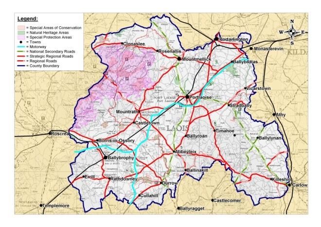
2021 2027 APPENDIX 6: LANDSCAPE CHARACTER ASSESSMENT Laois County Development Plan 2021 - 2027: Laois ...
←
→
Page content transcription
If your browser does not render page correctly, please read the page content below
2021 - 2027
LAOIS COUNTY COUNCIL
CHOMHAIRLE CHONTAE LAOISE

APPENDIX 6: LANDSCAPE CHARACTER
ASSESSMENT
Laois County Development Plan 2021 – 2027:
January 2022
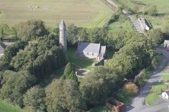
TABLE OF CONTENTS

1. INTRODUCTION                                        1

2. THE LANDSCAPE OF COUNTY LAOIS-HUMAN INFLUENCES      3

3. THE LANDSCAPE OF COUNTY LAOIS-PHYSICAL INFLUENCES   9

4. LANDSCAPE TRENDS IN COUNTY LAOIS                    17

5. LANDSCAPE CHARACTER TYPES                           22
1. INTRODUCTION                                        What    is        landscape        character
                                                       assessment?
How is landscape defined?                              Landscape Character Assessment is a
                                                       process which describes, maps and
Landscape is defined in many different
                                                       classifies landscapes objectively. It can be a
ways but in current guidance there is broad
                                                       tool     to   aid   decision-making        and
agreement that it is a combination of our
                                                       management or simply to promote particular
physical and perceived surroundings.
                                                       attractions. Defining landscape character
Department of the Environment and Local                enables an understanding to be formed of
Government (DoEHLG) defines landscape                  the inherent value and importance of
as “all that is visible when looking across            individual landscape elements and the
areas of land.”                                        processes that may alter landscape
                                                       character in the future. The cultural and
According to the European Landscape                    ecological aspects of the landscape cannot
Convention 2000 landscape is                           be divorced from its physical and visual
                                                       characteristics so all these elements are
“An area as perceived by people, whose                 considered.
visual features and character are the
result of the action of natural and / or               Why carry out a landscape character
cultural      (that      is      human)                assessment of County Laois?
factors…landscapes evolve through
time as a result of being acted upon by                Under Planning Legislation, it is a legal
natural forces and human beings”                       requirement:

                                                       The Local Government (Planning and
“As a key element of individual and social             Development) Act 2000 (Part II, S10 (e) and
well being and quality of life, landscape              1st Schedule, Part IV (7) requires every
plays an important part in human fulfilment            planning authority to include objectives in
and in reinforcement of (European) identity.           their Development Plan for the “preservation
It has an important public interest role in the        of the character of the landscape where,
cultural, ecological, environmental and                and to the extent that…the proper planning
social fields and constitutes a resource               and sustainable development of the area
favourable      to    economic       activities,       requires it, including the preservation of
particularly tourism”                                  views and prospects and the amenities of
                                                       places and features of natural beauty or
While the Countryside Agency, England                  interest”
regards
                                                       • Ireland ratified the European Landscape
“Landscape as about the relationship                   Convention in 2002 and must adopt national
between people and place. It provides                  measures to promote landscape planning,
the setting for our day-to-day lives. The              protection and management.
term does not mean just special or
designated landscapes and it does not                  The National Landscape Strategy for
only apply to the countryside.                         Ireland 2015-2025 sets out a number of
Landscape can mean a small patch of                    actions which national -government are
urban wasteland or as much as a                        committed to. These include the production
mountain range…It results from the way                 of a National Landscape Character
that different components of our                       Assessment,     a   National   Landscape
environment–both natural and cultural–                 Character Map and Section 28 Guidelines
interact together and are perceived by                 on local landscape character assessments.
us.”                                                   Once the above has been completed local

                                                   1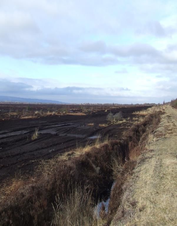
authorities will be required to prepare              KEY OBJECTIVES OF THE LANDSCAPE
individual landscape character assessments           CHARACTER ASSESSMENT:
for their functional areas.
                                                        1. To improve the understanding of the
Context influencing the Landscape                          landscape in County Laois in terms
Character -Assessment of County Laois                      of its inherent and unique character
                                                           and to identify what key elements
The Landscape Character Assessment and                     should be preserved, conserved or
the Development Plan will be informed by                   enhanced.
existing national, regional and local planning          2. To predict the broad pattern of future
documents and policies including the                       changes and devise policies and
following                                                  objectives as guidance to planners
                                                           and other parties which will ensure
   •   European Landscape Convention                       that change is complimentary to
       2000,                                               landscape character. Sensitivity and
   •   DoEHLG Landscape and Landscape                      capacity should be given due
       Assessment: Consultation Draft of                   consideration in all aspects of
       Guidelines for Planning Authorities,                decision-making.
       2000, and other guidelines relating              3. To assist in the achievement of
       to architectural heritage, including                sustainable      development,      the
       Conservation Areas and Setting of                   underlying principle of all current
       Protected Structures,                               planning practice and legislation, by
   •   Project Ireland 2040 – is the                       promoting a unified approach to
       overarching strategy to make Ireland                landscape         planning        and
       a better country for all its people                 management which links policies
       through the development of physical                 and recommendations for landscape
       infrastructure      and     supporting              character to existing planning
       business and communities.                           policies.
   •   Regional Spatial and Economic
       Strategy for the Eastern and                  Laois County Council is currently reviewing
       Midlands Assembly area. This plan             it’s County Development Plan which will
       identifies discrepancies in approach          include policies for landscape protection
       between counties in preparing LCAs.           and     conservation.   This     Landscape
       It recognizes the need for a national         Character      Assessment       will   form
       landscape character assessment to             supplementary guidance providing a
       provide consistency in approach and           detailed understanding of the landscapes in
       a framework for regional and local            County Laois during the period of the
       landscape character assessments.              Development Plan 2021-2027.
   •   Laois County Council’s County
       Development Plan 2017-2023 and                How    is    Landscape           Character
       current review of the Plan,                   Assessment carried out?
   •   Landscape character assessment of
       adjoining     local    authorities,  if       This Landscape Character Assessment
       available; of the five counties               describes the landscape of Co. Laois
       bordering Laois each has completed            including:
       landscape character assessments:
       North Tipperary, Kilkenny, Offaly,            • Physical elements - landform, land cover,
       Carlow and Kildare.                           geology, vegetation cover, hydrology and
                                                     ecology.

                                                 2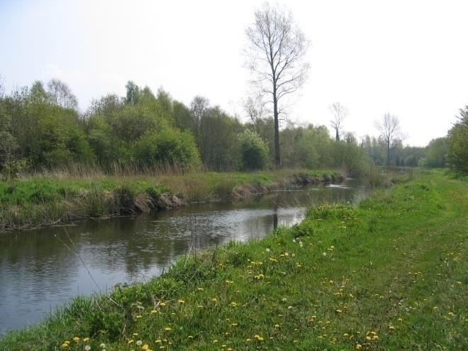
• Visual characteristics - type and extent of       2   THE   LANDSCAPE   OF
views, enclosure and patterns formed by
physical elements.
                                                    COUNTY       LAOIS-HUMAN
                                                    INFLUENCES
• Less tangible aspects such as historical
and cultural associations, archaeology,             2.1 Overview
remoteness, tranquillity and aesthetic
quality.                                            In this section, an overview is provided of
                                                    past human activity in County Laois, the
POLICIES AND RECOMMENDATIONS                        influence of past practices on the landscape
                                                    and the extent to which archaeological and
Policies have been formulated to assist the         historic elements survive in, or influence,
development of related planning policies,           the modern landscape.
promotion of strategies and development
management within the county. They are              2.2 Prehistoric Laois
intended to protect and enhance landscape
character, and facilitate and guide                 County Laois has a rich and varied
sensitively designed development. Policies          landscape with historic features dating back
are general in nature and are concerned             to prehistory and many well-known tourist
with broad principles of good practice. The         attractions that are related to its heritage.
aim of the suggested policies is to enhance         The county retains a strong connection with
and maintain landscape character within the         traditional agriculture and the landscape
broader      goal     of    accommodating           supports a wide range of ecological habitats
development in a sustainable manner.                despite recent rapid growth of its
                                                    settlements. It is the interaction of these
CONSULTATION                                        elements that will influence landscape
                                                    character for future generations.
There was public consultation alongside
statutory consultation [for example with            The relatively accessible landform of County
DoEHLG] for the County Development Plan.            Laois together with its network of navigable
Where necessary, the Landscape Character            river corridors, encouraged successive
Assessment was amended to take account              waves of visitors to settle in the county over
of relevant comments made during this               time. The earliest people in County Laois
period.                                             were small bands of Mesolithic migratory
                                                    hunters-fishers-gatherers who appeared
                                                    about 8500 years ago. Neolithic farmers
                                                    followed and left burial mounds in Clonaslee
                                                    and Cuffsborough and artifacts such as a
                                                    chert javelin head near Glenkitt in Slieve
                                                    Bloom

                                                    The early Bronze Age was characterised by
                                                    a considerable expansion of settlement in
                                                    the county. The people of this era preferred
                                                    well drained lightly forested upland
                                                    pastures. These lightly forested slopes were
                                                    easier to clear with the available technology
                                                    and the cleared soil was worked until
                                                    depleted. Pasture and cattle raising was the
                                                    key to the Bronze Age economy in the
                                                    county.     The      improved      technology

                                                3
associated with the Bronze Age also                  county. Between 550 and 600, St. Canice
assisted the farmers in improving control            founded Aghaboe Abbey and St. Mochua
over their environment, by more extensive            set up a religious community at Timahoe.
farming practices and forestry clearances.           An early Christian community lived at Dun
                                                     Masc or Masc’s fort, on the Rock of
The late Bronze Age is characterised by              Dunamase.
increased deposition of hoards and this may
represent a general response to climatic             Timahoe Round Tower
deterioration in the latter half of the second
millennium. During this period, climate
change and the impacts of farming are
believed to have been partially responsible
for the development and spread of blanket
bog; tree regeneration was hampered by
farming practices and soils became wetter,
less well drained and more conducive to
peat creation.

Surviving from the Bronze Age settlers are
examples of the fulacht fiadh or cooking
place, weaponry, ornaments and hill forts
such as Clopook and Monelly. Their                   The introduction of Christianity also
megalithic monuments may include the                 facilitated closer contacts with the Roman
Ass's Manger (possibly a wedge tomb near             world, easing the transfer and spread of
Luggacurren, a stone circle in nearby                technologies such a new ploughs and the
Monamonry ("Druid's Altar"), and the                 horizontal     mill.    These   technologies
standing stone in the motte and ring fort at         improved agricultural productivity and
Skirke near Borris-in-Ossory.                        encouraged           population    increases.
                                                     Population expansion led to the on-going
The pre-Christian Celtic Iron Age is one of          construction of ringforts and raths. These
bloody conquest by a succession of ruling            may be identified as banks marking the
dynasties. Iron Age activity in the county is        perimeter of enclosed single farmsteads
largely derived from ring barrows [at                involved in a principally pastoral economy.
Ballydavis] and forts, and a wealth of heroic        They are typically sited on sloping sites
literature originally in oral form. A marked         within lowland areas where there was
decline in agricultural activity suggests a          access to better drained soils and views
contraction in settlement during the Iron            over the surrounding landscape. Crannogs
Age.                                                 were broadly contemporary with ringforts
                                                     and raths, occupying semi-artificial islands
By the first century AD, Laois was part of           of timber, sods and stones. To date, no
the Kingdom of Ossory. The county was                crannogs have been identified within County
divided roughly into seven parts, which were         Laois possible due to the lack of major
ruled by the Seven Septs of Laois: O’More            surface water features within the county.
(O’Moore), O’Lalor, O’Doran, O’Dowling,
O’Devoy (O’Deevy), O’Kelly and McEvoy.               2.4 Medieval Laois

2.3 Christianity                                     After 1150, the continental Roman Catholic
                                                     Church began to assert its authority over
With the advent of Christianity, religious           the independent churches of Ireland. As
communities became established in the                religious orders with strong ties to Rome

                                                 4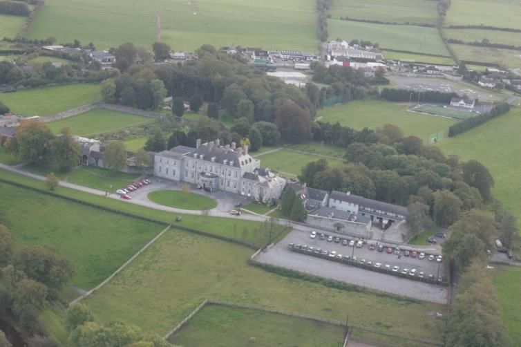
replaced older religious communities, the             Rock of Dunamaise C.1250
wooden buildings of the early Christian
churches in Laois gave way to stone
monasteries.      The    Augustinians      and
Dominicans established themselves at
Aghaboe Abbey, while the Cistercians took
over an older religious community at
Abbeyleix. The Cistercians played a
significant role in agricultural development
and divided monastic lands into farms or
granges. They also modified the landscape
considerably, clearing woodlands and
reclaiming wetlands. Their preference for
richer, freely draining soils better suited for
cultivation remained throughout the Norman
period.

Aghaboe Abbey
                                                      Several of the county’s towns were first
                                                      established as Norman boroughs, including
                                                      Castletown, Durrow and Timahoe. From
                                                      1175 until about 1325, Normans controlled
                                                      the best land in the county, while Gaelic
                                                      society retreated to the bogs, forests and
                                                      the Slieve Bloom Mountains. The early 14th
                                                      century saw a Gaelic revival and a
                                                      simultaneous decline in Norman influence.
                                                      The Dempseys seized Lea Castle, while
                                                      Dunamase came into the ownership of the
                                                      O’Mores. Tower houses belonging to Irish
                                                      chieftains of this era survive at Ballaghmore
Around the same time, the Normans seized              and Cullahill, both decorated with Sheila-na-
control of most of Ireland. In Laois, the             gigs.
fortress on the Rock of Dunamase was part
of the dowry of the Irish princess Aoife, who         2.5 Post-Medieval Laois
was given in marriage in 1170 to the
Norman warrior Strongbow. Advancing                   The sixteenth and seventeenth centuries
Normans surveyed the county from wooden               witnessed two colonisations by English
towers built on top of earthen mounds,                forces. The first occurred in 1556, when
known as mottes. They also built stone                Thomas Radclyffe, 3rd Earl of Sussex
fortresses, such as Lea Castle outside                dispossessed the O’Moores and attempted
Portarlington.                                        to replace them with English settlers. This
                                                      led to a long drawn-out guerilla war in the
                                                      county and resulted in a small English
                                                      community clustered around garrisons.
                                                      There was a much more widespread and
                                                      successful plantation in the county in the
                                                      17th century which expanded the existing
                                                      English settlement with more landowners
                                                      and tenants from England. After the Battle
                                                      of Kinsale in 1601 the Gaelic order

                                                  5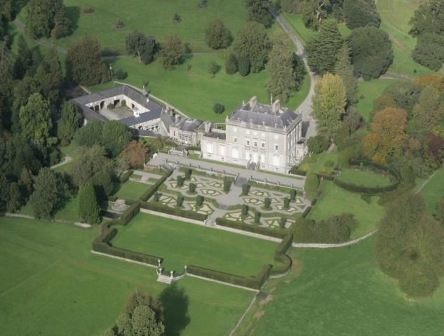
collapsed. By 1610 the seven septs of                woodland and riverside locations. The
Laois, their wider families and retainers            greatest period of “Big House” and
were transplanted to remote parts of                 demesne creation in County Laois was
Connacht and Munster. The rest of the                between 1770 and 1840 when many of the
century saw further reduction of Roman               county’s finest houses including Abbeyleix
Catholic landowning in the county reinforced         House, Ballyfin House, Durrow Castle and
by the Penal Laws.                                   Emo Court were built. In 1836, a branch of
                                                     the Grand Canal was extended to
The new settlers were eager for agricultural         Mountmellick, further stimulating industry in
improvement and landlord demesnes. As                that town. Other landscape additions in this
the seventeenth century progressed, the              period include the glebe house, Protestant
estate system spread throughout most of              churches and police barracks.
the populated, good to moderate lands of
the county. A feature of this period is how          2.6 Pre-Famine Laois
much of the earlier settlement evidence is
now supplanted by landlord demesnes, in              The decades prior to the Famine were
the eastern half of the county especially.           characterized      by     relative    calm,
                                                     consolidation, enclosure and landscaping.
Among the new colonists to the county were
two religious groupings, the Huguenots and           In an extract from The New London
Quakers who settled in Portarlington and             Gazetteer (1826)] Laois was described as
Mountmellick respectively in the latter part         follows:
of the seventeenth century and made major
contributions to County Laois in terms of            “Queen’s County, a county of Ireland,
their social, cultural, economic and                 bounded N and W by King’s county, E by
architectural endeavours.                            Kildare and part of Carlow, S by Kilkenny,
                                                     and SW by Tipperary, 32 English m. long,
                                                     and as many broad. Along the W
The plantation marked a new era of
                                                     boundary runs a range of high and steep
landscape change centred on the demesne
                                                     mountains, and in the E the Dysart hills
and influenced by prevalent concepts
                                                     form a prominent and picturesque object.
concerning        agricultural     improvement
                                                     The lands have been thus distributed –
operating      within     a    reformed    and
                                                     Arable land, pasture, and meadow:
6ationalized field system. The settlers
                                                     210,000 acres; Woods and plantations:
embraced new crops, planting of deciduous
                                                     1,300 acres; Bog, mountain, and waste:
trees, improved cattle and sheep breeds
                                                     21,000 acres; Roads: 2,000 acres; Total
and agricultural techniques including liming,
                                                     area: 235,300 acres. Principle rivers, the
drainage and enclosure. Agricultural
                                                     Barrow       and     Nore.     Chief    towns,
improvements and demesne creation was
                                                     Maryborough,           Portarlington,      and
facilitated by a rent paying tenantry.
                                                     Stradbelly. Almost every description of
                                                     soil is found in this county, from a very
Industrial interests also gave settlers the          stiff clay, to a light but fertile sandy loam.
confidence and resources to establish                The principal mineral productions are
estates and large unfortified residences.            coal and limestone. It sends 3 members
The defensive bawns were replaced by                 to the British parliament. Pop. 90,000.”
walled gardens. Accompanying this was an
enthusiasm for lavish houses, with ornate
gardens. Once the natural landscape design
associated with Capability Brown became
dominant, there was a shift in the location of
houses to the more scenic upland,

                                                 6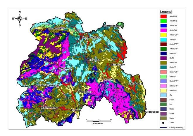
Abbeyleix House and Demesne           Ballyfin House and Demesne

                                  By the 1840's the population of County
                                  Laois was three times its present number.
   Durrow Castle                  Then came the Great Famine of 1845–9
                                  which had a devastating impact on the
                                  county. The opening of the workhouse at
                                  Donaghmore and the many small ruined
                                  houses especially in the foothills of the
                                  Slieve Bloom Mountains bear testimony to
                                  this calamity.

                                  2.7 Post-Famine Laois

                                  The policy approach to the famine was
                                  informed by an initial desire to rid the
                                  agricultural system of its perceived
                                  backwardness and obstacles to agricultural
                                  modernisation. Hence, in particular, small
                                  farmers were targeted and through the
Emo Court                         ratings clauses,     large numbers of
                                  smallholders were evicted. This clearing of
                                  the land, combined with the introduction of
                                  ladder fields as a means to rationalise land
                                  ownership, removed many of the earlier
                                  field    systems    within    the    county.
                                  Accompanying developments that had a
                                  major     landscape    impact    were    the
                                  overwhelming increase in pasture at the
                                  expense of tillage and the consolidation of
                                  large scale farmers who tended to rent the
                                  limestone rich pastures, whilst the
                                  remaining farmers most frequently had to
                                  contend with producing on marginal land.

                                  In the aftermath of the famine, strong
                                  farmers and landlords increased their

                              7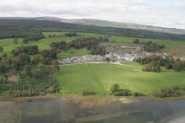
holdings at the expense of weaker                      This loss of labour is often particularly acute
neighbours, and the pastoral sector                    with regard to the traditional maintenance
increased, helped by the development of                and management of key agricultural
the railways and expanding English                     landscape features such as hedgerows and
markets.                                               ditches. However, programmes such as the
                                                       Rural Environment Protection Scheme and
A combination of declining numbers of                  the recent CAP reforms are again stressing
landlords, in large part due to the increasing         the links between agricultural activity and
assertion of agrarian rights and a less                landscape maintenance.
sympathetic governmental regime, and the
establishment of the Land Commission                   Whilst the county retains a rural landscape,
resulted in many landlords transferring their          the pace of change over the past thirty
land to former tenants with a consequent               years, in landscape and social terms, has
decline in the extent of many estate                   been considerable. Although parts of the
holdings. The War of Independence, and                 county [especially the north and east] are
the Civil War that followed it, also led to            under development pressure in the form of
many perceived symbols of the landlords’               housing requirements, other parts [the west
reign being destroyed during this period.              and south] are suffering population
                                                       stagnation, decline and associated loss of
2.8 Post-Independence                                  rural services. Human activities will continue
                                                       to play the most influential role in landscape
Following independence, land reform is                 retention and change, whether through
thought to have contributed to an increase             continued      agricultural   decline,    rural
in the division of land as former tenants              diversification in the form of increased
sought to define the boundaries of their               afforestation or development of golf
newly acquired freeholds. The introduction             courses, the exploitation of natural
of rural electrification and group water               resources such as wind farming, aggregates
schemes had both social and landscape                  and peat extraction and the roll-out of large
impacts in North County Laois with                     infrastructure projects.
significant improvements on the quality of
life for rural householders, as well as the
introduction into the landscape of water
treatment facilities, reservoirs and electricity
poles and pylons.

The economic emergence of Ireland over
the last forty years, particularly following the
state’s entry into the EEC in 1973, has had
a profound influence upon the social,
economic and physical development of the
county.

Today, agriculture remains the predominant
land use in County Laois with 109,424 ha
under agricultural production. Dairying and
cattle rearing remain the key agricultural
activity. Associated with the changes in the
agricultural sector within the county, is an
increase in part time farmers and the
accompanying decline in farm employment.

                                                   8
3. THE LANDSCAPE OF each rock type generally being associated
with particular landscapes.
COUNTY LAOIS-PHYSICAL
INFLUENCES Much of the county is composed of
limestone lowlands from the lower
Introduction Carboniferous Series (approximately 325
million years ago), and generally covered by
This section of the Landscape Character glacial deposited sediments. The limestone
Assessment provides a brief overview of the in this area supports generally good quality
elements which form the landscape pastoral farmland but in other areas such as
character of County Laois. Laois is an Cul na Mona [between Portlaoise,
inland county, entirely landlocked and, Mountrath and Abbeyleix] and the
uniquely amongst Irish counties does not southwestern boundary with County
border any other counties with a sea coast Tipperary, the poorly drained geology has
led to the creation of peatland areas since
In order to understand the landscapes the end of the last glacial period in Ireland
within County Laois, it is necessary to (approximately 10,000 years ago, the
outline the physical and historical influences Midlandian period).
that have created the contemporary
landscape. Elsewhere within the county, blocks of
harder, less easily eroded limestone create
The interplay between bedrock or solid distinct landscape elements within the
geology, glacial processes, soil formation, wider, flatter limestone surround, by forming
hydrology and ecology has formed the basic small hills and stretches of limestone ridges.
materials upon which human activities have
impacted. This is a constant and ongoing In themselves, such hills and ridges are
inter-relationship with topography, access to not particularly elevated, (commonly
water and soil conditions influencing the around 200m OD); however they create
spatial distribution and types of human visual interest in an otherwise low lying
activities practiced within the county over area. Examples of these limestone ridges
the past several millennia. can be found east of Portlaoise
Although human habitation has been the The mountains and hills that rise above
most recent landscape influence, in many these lower areas are composed of a
ways it has been the most profound. variety of older rocks of differing age and
Patterns of land ownership, settlement composition. Old Red Sandstone is
development, agricultural and ritual generally found around the perimeter of
activities have all been modified in response these uplands, whilst the interiors are
to local variations of biotic and abiotic formed by far older Lower Palaeozoic rocks,
elements and constraints. A description of largely composed of greywacke, mudstone,
the physical landscape of County Laois is and slate.
presented below and is followed by an
overview and analysis of human activities Old Red Sandstone is a tough rock,
within the County Laois landscape from resistant to erosive influences and this
prehistoric to contemporary times. characteristic generally creates upland
moorland or blanket bog at the summits of
3.1 Solid Geology these areas. The Sliabh Bloom Mountains
formation is considered to contain the
The underlying geology of County Laois is greatest concentration of Old Red
formed from two principal rock formations, Sandstone rocks in the South Midlands.
93.2 Effects of Glaciation waterbodies and the predominantly
limestone bedrock.
Glacial deposition rather than erosion has
been the major landscape influence within The water table in the low lying areas is
the county. However, there are two areas generally very close to the ground surface
that clearly display the influence of erosive with the exception of the harder limestone
factors. The uplands were eroded as the ridges and hills. The water table in the
Midlandian ice sheets moved in a general uplands varies considerably depending on
southerly direction. Elsewhere glacial seasonality and may be within a few metres
deposits led to deposits of boulders, pebble, of ground level in winter, dropping to more
sand and mud and thereafter their than 20m
smoothing and rounding over by ice. below ground in the summer months.
3.3 Topography and Drainage 3.4 Soils
Upland areas and hills within the county In County Laois, the various types of soil
provide interest and contrast with the largely have developed from a combination of
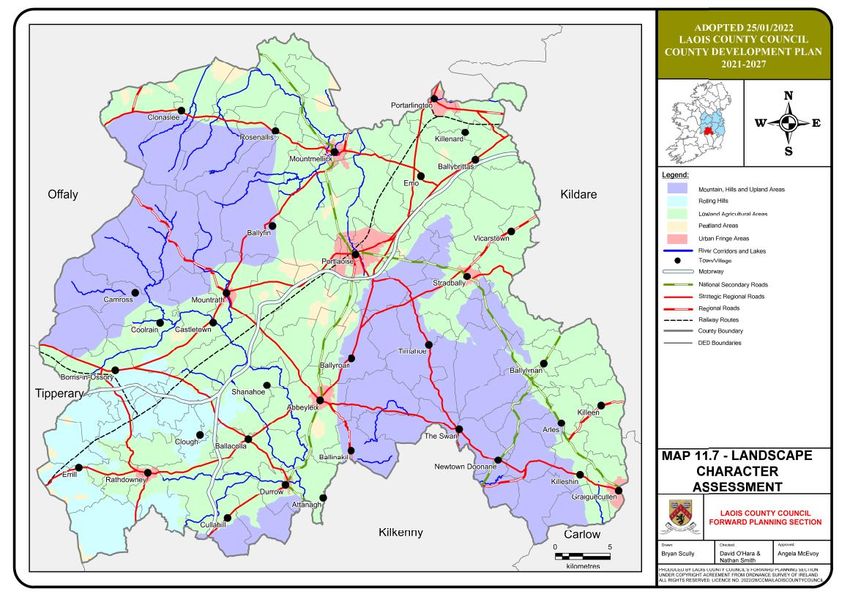
central lowland areas. Map 1 illustrates the numerous factors, most notably topography,
topography of the county. These uplands climate and geological parent material. The
are concentrated in the north-western and principal soil types identified within the
southern parts of the County and include county are illustrated in Map 2. Of the nine
the Sliabh Bloom Mountains [containing the principal soil types (great soil groups)
highest summits in the county], Cullahill identified in the National Soil Survey, the
Mountain, Cullenagh Mountain, Fossy most commonly occurring type or group is
Mountain and Killeshin Hills. the grey brown podzol. This type is located
mainly in the southwest [Abbeyleix,
Map 1: Contour Map of County Laois Ballacolla, Rathdowney, Shanahoe areas]
and east [Stradbally, Ballylynan areas] of
the county. Geologically, this soil is derived
from glacial till composed generally of
limestone. It has a heavy texture although
the structure is sufficiently good to facilitate
drainage. The soil type is suited to most
agricultural enterprises although the heavier
textured types in this category are more
poorly drained and therefore primarily suited
to pastoral uses.
The next most frequently occurring soil type
is the gley which is generally found in the
southeast [Bilboa, Rossmore, Killeshin,
Timahoe areas] and low lying ground in
Drainage in the county is largely defined by parts of the west [Ballybrophy, Borris-in-
the Rivers Barrow, Nore and Erkina and Ossory areas] of the county. Glacial till
their various tributaries mainly flowing in a comprising mostly shales is the foundation
north west - south east trajectory. Apart geology for this soil type. In terms of
from minor [man-made] ones at Ballyfin, agricultural uses, this soil type is limited
Grantstown, and Heywood, there are no largely due to weak structure and poor
significant natural lakes in the county drainage characteristics. Pastoral uses can
reflecting the lack of drumlins to capture be considered although this activity is
restricted by the vulnerability of this soil type
10to poaching by livestock. In addition, these Table 1:No. of Farms Classified by Farm
soils are likely to be highly productive from a Size (AAU) at County Level
forestry cropping standpoint.
Peat soil types account for just over 17% of Location 0- 10- 20- 30- 50- 100 Total Average
10 20 30 50 100 + Farm
the soil cover in the county. Much of this is
Size
associated with the raised bogs on the
County 528 605 557 783 698 141 3312 37
southwestern eastern edge of the county, in Laois
the central areas around Portlaoise,
Mountrath, Mountmellick and Abbeyleix and Pastoralism, with an emphasis on beef
further north in the foothills of the Sliabh production, is the predominant agricultural
Blooms. This soil type is not suited to activity in County Laois, with 59% of the
commercial agriculture. However it does county’s farmers engaged in this form of
offer considerable potential in terms of enterprise. A further 11% concentrate on
afforestation, and increasingly amenity [as dairying. There are a number of specialist
in Lough Boora in County Offaly] and green areas of agricultural production in the
energy. Regarding green energy, there is a county. For example, tillage farming is most
current planning application with the Council common in the east and north bordering
for a wind farm project on a section of Carlow and Kildare with dairying most
worked-out bogland southwest of evident in the south.
Rathdowney.
The composition of farm household income
Map 2 Soil Types Of County Laois is changing too, making off farm
employment and the development of
alternative enterprises necessary to ensure
survival. There are 344 no. farms reporting
gainful non-agricultural activity on the farm
and for a significant number of farmers in
Co. Laois (28%), conventional farming is
now regarded only as a part time or a
subsidiary occupation.
Map 3: Corine Landuse Map of County
Laois
3.5 Landuse
Agriculture is the predominant landuse in
the county. According to the 2010 census of
agriculture, the average farm size in County
Laois is 37 hectares, which is higher than
the national average of 33 hectares. There
are 3,312 farms in County Laois of which
50% are less than 30 hectares in size.
Furthermore, 52% of the land in the county
is designated as disadvantaged.
113.6 Afforestation variety as is the case with the majority of the
locations in County Laois.
One alternative rural enterprise in County
Laois which is proving increasingly It is vital that an holistic approach is adopted
attractive for farmers and investment in terms of additional and replacement
companies alike is afforestation. Almost afforestation throughout the county so that
15% of Co. Laois is forested comprising visual amenity, biodiversity, habitat
4,430 hectares of private plantings and protection, water quality and tourism
15,950 hectares mainly undertaken by promotion are afforded due consideration as
Coillte. well.
There was a major afforestation programme Map 4: Coillte Plantations in County
implemented between 1984 and 2004 when Laois
6,578 hectares of land was planted. The
majority of the schemes to date have been
in the upland more marginal areas of the
county [areas that incidentally often coincide
with amenity and natural heritage
designations] with heavy concentrations in
the Sliabh Boom Mountains, Cullenagh
Mountain, between Ballybrittas and
Vicarstown and in the southeast around
Swan, Wolfhill, Rossmore and Crettyard.
There are also 4,990 hectares of native
woodland in County Laois. Broadleaf
woodland and copses are more prevalent in
lowland areas and mature trees encircle
many historic features such as raths and Landscape management in rural areas
historic graveyards, forming prominent and varies. It is generally most intensive around
attractive landscape elements. Remnants of commercial tillage farms in the east which
old estate woods and ornamental have a manicured appearance, but
plantations are still evident in a number of becomes less intensive in the more
locations throughout the county. marginal farmland areas of the northwest
and southeast and very poor around the
In general the county is reasonably well fringes of expanding urban areas where
furnished with deciduous tree species. farming is under threat and becoming a less
Beech, elm, ash, poplar, sycamore and viable industry. The rural landscape
alder are all still in abundance with oak contains numerous trees growing often as
present to a lesser degree. Forty-five mature stands or shelterbelts and within
constituent sites were surveyed as part of hedgerows.
the National Survey of Native Woodland
[BEC Consultants 2003-2008]. The optimum Hedgerows vary in terms of style, form and
sites in terms of native woodland species content but are generally well
conservation value include Ballyfin managed along road corridors becoming
Demesne, Dunmore Demesne, Emo Court less well maintained in between fields. In
and Grantstown Wood. many areas hedgerows have been lost and
replaced with post and wire fences, giving
From a landscape perspective, afforestation the countryside a much more open
can have major negative implications for the character and contributing to decline in
environment especially where the pre- landscape condition.
dominant species type is of a coniferous
12Deep drainage ditches are a distinguishing have been identified as SAC’s. There are
feature along many rural roads particularly currently 9 SAC’s in County Laois.
in peatland areas. Stonewalls, cylindrical
stone gateposts and iron gates are also Special Protection Areas (SPA’s) are areas
common boundary treatments. designated under the European Community
Birds Directive for the protection of birds
3.7 Extractive Industry and their habitats. There is one SPA in
County Laois: the Sliabh Bloom Mountains
Mineral extraction is a significant industry in the northwest of the county bordering
and demand for aggregates is certain to Counties Offaly and Tipperary
continue. There are already a large number
of quarries and pits in County Laois and The following are the locations of the
large areas identified as having high existing and proposed NHA’s, SAC’s and
aggregate potential, particularly in the south SPA’s in County Laois:-
of the county. There are also the remnants
of slag heaps associated with the now Special Areas of Site Code ½” Map
defunct coal mining industry centred on Conservation Number
Wolfhill and Rossmore. Any future (SACs) in County
development must be carefully planned to Laois (as identified
on Map No. 5) Site
avoid unnecessary adverse landscape
Name
impacts. River Barrow And 002162
River Nore
3.8 Ecology and Habitats Clonaslee Eskers 000859 38
and Derry Bog
County Laois has a rich natural heritage that Lisbigney Bog 000869 44
includes scenic river valleys, rolling Mountmellick 002141
farmland, uplands, watercourses and a Slieve Bloom 000412 38/44
network of mature hedgerows all of which Mountains
are influenced by land use and Coolrain Bog 002332
Knockacollier Bog 002333
management. National Heritage Areas
(NHA’s) were derived from the former Areas
of Scientific Interest (ASI’s) and include the
best remaining areas of Irelands natural and
semi-natural habitats.
Sites have been selected by virtue of having
special scientific significance for one or
more species, communities, habitats,
landforms, or geological or
geomorphological features, or for a diversity
of natural attributes. There are currently 31
NHA’s in County Laois.
Special Areas of Conservation (SAC’s) are
designated under the European Community
Habitats Directive to maintain biodiversity
and restore the conservation status of
certain species of flora and fauna. Areas in
County Laois that support rare, endangered
or vulnerable species that require special
protection and positive habitat management
13Natural Heritage Areas (NHAs) in Co Laois (as identified on Map No. 5]
Site Name Site Main habitat or species
Code
Annaghmore Lough Fen 000413 Calcareous fen with willow and birch scrub
Ballylynan 000857 Grassland, wet meadows
Barrow Valley At 000858 River, canal, grassland, marsh
Tankardstown Bridge
Clonaslee Eskers And 000859 Esker, raised bog
Derry Bog
Clonreher Bog 2357 Raised bog
Clopook Wood 000860 Ash/hazel woodland, limestone hill
Coolacurragh Wood 000862 Birch/alder woodland, fen peat
Coolrain Bog 000415 Midland raised bog (with Knockacollier Bog, these two bogs are the most
southerly intact examples of true Midland Raised Bogs in the country)
Cuffsborough 000418 Grassland used by Greenland White-fronted geese
The Curragh And Goul 000420 Wet meadow, river, winter feeding site for Greenland White-fronted Geese
River Marsh
Delour River Nr Lacca 000864 Oak/birch woodland, river, wet grassland
Manor
Derries Wood 000416 Disturbed raised bog, disused gravel pit, conifer plantation, lake, reedbed,
important insect populations
Dunamaise Woods 001494 Limestone hills, oak/ash woodland
Emo Court 000865 Semi-natural mixed (oak/ash with beech) woodland, lake, parkland, amenity
grassland
Forest House Wood 000874
Grand Canal 002104 Canal, wetland, grassland
Grantstown Wood and 000417 State-owned nature reserve. Lake in transition through fen to alder/willow.
Lough Important invertebrate fauna
Kilteale Hill 000867 Limestone hill, hazel/ash woodland
Knockacollier Bog 000419 Midland raised bog, Birch and alder woodland. One of the few intact bogs
south of the Slieve Blooms
Lisbigney Bog 000869 Raised bog
Mannin Wetland 00868 Species-rich fen
Monaincha Bog/ 00652 Raised bog
Ballaghmore Bog
Ridge Of Portlaoise 000876 Esker ridge, ash/hazel woodland, species-rich grassland, disused gravel pits
River Barrow And River 002162 River, wetland, woodland
Nore
River Nore/Abbeyleix 002076 River, site for Freshwater Pearl Mussel (international importance), Twaite
Woods Complex Shad (Vulnerable), wet grassland, mixed deciduous woodland of great
antiquity and species diversity, with specimen oak
Rock of Dunamaise 000878
Shanahoe Marsh 001923
Slieve Bloom Mountains 000412 Old Red Sandstone mountains, mountain blanket bog, Peregrine Falcon, Hen
harrier, red grouse
Stradbally Hill 001800
Timahoe Esker 000421 Esker ridge, Hazel/Ash woodland
14Special Protection Areas (SPAs) in Co
Laois (as identified on Map No. 5) Further development of towns and villages
must be carefully planned to avoid creating
Site Name Site Main habitat or linear extensions of large scale housing on
Code species approaches to towns and villages.
Slieve 004160 Whooper Swan, Collectively this type of development has
Bloom Corncrake, Hen the potential to threaten the rural character
Mountains Harrier, Merlin, of the whole county.
Peregrine
One-off house rural housing is a major issue
Map 5: Natural Heritage Designations throughout County Laois with particularly
strong concentrations in the north and east
of the county and in the vicinity of all the
main urban settlements. An appropriate
planning response is necessary to avoid
houses being built that are out of character
within the rural context. The Regional
Economic and Spatial Strategy (RSES)
have identified a hierarchy of settlements in
order to accommodate development in the
best way possible.
The Council’s interpretation of the RSES
3.9 Settlement and Built Heritage through planning policy will seek to promote
the retention and enhancement of the
County Laois has an impressive built identity of individual settlements including
heritage. The three main towns, of landscape setting and avoiding further loss
Portlaoise, Portarlington and Mountmellick of character. The rural housing policy of
have relatively intact cores while Abbeyleix Laois County Council will also seek to limit
is designated as a Heritage Town. There the impact of one off rural housing on the
are many other urban settlements across landscape. One of the base criteria is the
the county that are significant in terms of quality of the design of one-off houses and
built heritage and cultural associations their potential impact on landscape
including the villages of Ballinakill and character.
Timahoe which was the site of an abbey
founded by St Mochua in the 6th Century. 3.10 Infrastructure
Nonetheless, the historic structure of urban Development pressure from the Dublin
settlements in the county is under threat Metropolitan Area and recent road and rail
from unprecedented population growth. improvements have led to increased
Urban areas are expanding, particularly in commuting between County Laois and
northern and eastern areas due to their Dublin. This has placed greater pressure on
proximity to the Dublin metropolitan area. county roads that link primary road
Many settlements such as Portlaoise and corridors.
Portarlington have grown in size at such a
rate that the historic centres are in danger of Current planning policy is to create an
becoming detached from the majority of integrated public transport system and
their populations and the relationship reduce the need and demand for travel,
between urban area and landscape setting particularly by private car. Improvements to
is being threatened. public transport networks will be carried out
alongside road improvements to facilitate
15more sustainable and efficient commuting It is Council policy that masts should avoid
whilst also improving local employment areas of high visual value or archaeological
opportunities to reduce the need to importance and be co-located where
commute in the long term. feasible.
Upgrading of the rail infrastructure will 3.11 Tourism
alleviate some pressure on rural roads in
the county. The opportunity for further rail County Laois has significant tourist potential
networks elsewhere in the county would in its own right. Rich in contrast, there is
increase sustainable transport provision but provision for a wide range of outdoor active
it is crucial that any new and reopened rail pursuits including golfing, walking, vintage
lines are designed to reflect landscape car-rallies, music events, heritage tours and
character and minimise the loss of existing equestrian sports.
landscape character elements such as
vegetation and archaeology. Emo Court and Gardens, Heywood
Gardens, Rock of Dunamaise, Donaghmore
Rapid urban expansion has also put existing Famine Musuem, Sliabh Bloom Mountains
water and wastewater services under and associated mountain bike trail and
pressure. In many of the county’s towns the Abbeyleix Heritage House are the main
capacity of treatment plants has been tourist destinations in the county.
reached and exceeded. This is posing
implications for further economic Improved transport infrastructure,
development. Improvements to this element particularly links to the Greater Dublin Area
of infrastructure will be an integral objective means that Laois is a very accessible and
of the new Development Plan. attractive destination for short breaks for
visitors in Ireland or as part of a longer stay
The continued growth of County Laois is by visitors from abroad.
putting current energy generation under
significant strain and there are a number of Future proposals to increase the tourism
planned improvements to electrical product at many of these sites will require
infrastructure over the life of the new County sensitive siting and consideration for the
Development Plan. These include new landscape within which it needs to be
transmission lines and opening of a major integrated.
substation between Portlaoise and
Timahoe.
Renewable energy provision in Laois is a
priority having regard to local, regional and
national policy. The wind energy strategy of
this plan has identified a number of areas in
the county with potential for wind energy
generation.
Telecommunications Infrastructure is
becoming a critical factor in order to deliver
on the future requirements for a sustainable
County and address economic
competitiveness, connectivity and social
inclusion.
164. LANDSCAPE TRENDS IN predict the broad pattern of future changes
and devise policies and objectives which will
COUNTY LAOIS assist in ensuring that change is
complimentary to landscape character.
Landscape trends have been identified to
predict the broad pattern of future changes
The main forces for change which are
and devise policies and objectives which will
causing changes to the overall appearance,
assist in ensuring that change is
function and condition of the landscape can
complimentary to landscape character. The
be categorised as follows:
main forces for change which are causing
changes to the overall appearance, function
➢ Settlements, Built Structures and
and condition of the landscape are
Population Growth
categorised under the following headings:
➢ Infrastructure and Industry
settlements and built structures,
➢ Tourism
infrastructure and industry, tourism, rivers
➢ Rivers and Canals
and canals, agriculture and tree cover.
➢ Agriculture
➢ Tree Cover
The most likely forms of future development
are derived from these landscape trends.
4.1 Settlements, Built Structures and
Population Growth
Introduction
The growth of urban areas and built
The landscapes in County Laois are
development is the strongest trend that has,
constantly evolving in response to natural
is and will continue to influence landscape
forces and human activity. Glacial
character in County Laois. The strength of
movement shaped the topography into its
this trend will also have a knock-on effect on
present form and mans activities have been
all other factors that influence landscape
largely responsible for land cover since
character such as infrastructure and
farming began around the 4th Century.
industry, tourism, water bodies, agriculture
There have been several phases of history
and vegetation.
which have left their marks on the
landscape and which are evident today
Most settlements in the county, and
such as a patchwork of elements including
particularly those in the north and east,
passage tombs and pre Christian
have undergone rapid expansion of modern
earthworks, early Christian ecclesiastical
residential development. This trend is set to
buildings, Norman castles and walled
continue and has the potential to
settlements, 17th – 18th Century demesnes
permanently alter landscape character in
and field patterns and 18th – 19th Century
and adjacent to urban fringe areas.
buildings and structures.
The historic character which is highly
Today the pressures of change continue
evident in most settlements, large and
apace. Whilst many changes are a result of
small, is being diluted by new development
economic necessity, crucial to the
which adheres less to the local vernacular
development of the county, the impacts on
and is more homogenous in appearance
landscape character are potentially very
and layout.
damaging.
Sporadic one-off houses in rural areas are
This Landscape Character Assessment
becoming more common and are also
seeks to recognise what is valuable and
causing dilution of rural character where it
what elements should be preserved,
has been located insensitively. However,
conserved or enhanced. It also aims to
the desire of people to live in remoter areas
17could potentially give rise to opportunities to Biomass is likely to be a scale that will be
reverse the dereliction of traditional visually prominent so care should be taken
buildings by finding new uses for them. in design of its location, layout and setting.
4.2 Infrastructure and Industry Wind energy is also a visually prominent
form of development and should be located
Large scale infrastructure development away from highly sensitive landscapes and
such as motorway projects, waste water those of exceptional value. One landscape
treatment works etc resulting directly from character type in the county being
population growth in the county, will have considered for this form of development is
major effects on landscape and visual harvested peatland. While substantially
character which will be difficult to mitigate lower than hill and mountain locations, the
against because of the scale of such potential landscape impact will still need
development. Sensitive choice of location is careful appraisal.
likely to be the most important factor that
will limit negative impacts on the wider Solar energy has a significantly lower
landscape. Design of boundaries may also impact on the landscape from a visual
aid integration at a very local level. perspective. However, there is potential that
owing to scale, orientation and contours of
Ongoing planned extension to infrastructure the land that this form of development would
networks (electricity, water and sewage, have a negative impact on the landscape.
communications, Transport etc) is Care is therefore needed in the assessment
associated with population growth and the of applications to minimize the impact. In
demand for greater service capacities. general upland areas should be avoided for
These are causing often small-scale loss of this type of development.
features and character which, when seen
together have a potentially significant Hydro energy will be related to water bodies
cumulative effect on landscape character. so care should be taken to avoid adverse
impacts on national and European
To date there is little renewable energy designated ecological sites and other
provision in County Laois but it is a priority existing uses that are complimentary to the
policy at all levels of government and is maintenance of attractive and valuable river
being promoted to meet part of the county’s corridors.
increased energy requirements. Wind, solar
and to a lesser degree hydro energy are The demand for aggregates will continue
likely to be particularly viable because of the with increased development of the county. It
county’s water and wind resources but other is likely that quarries may be extended or
forms of renewable energy, such as bio- new areas for mineral extraction created to
energy and biomass are also potential meet demand.
contributors in this regard.
4.3 Tourism
Bio-energy has the potential to assist
diversification and enhancement of the rural Expansion and promotion of the tourism
economy but may result in reduced sector in the county is a key Council
biodiversity through the planting of large- strategy. There are potential opportunities to
scale single species plantations. These raise awareness of the wealth of visitor
would have a similar landscape effect to attractions that exist in the county in
commercial forestry. addition to the key established sites such as
the Sliabh Blooms, Emo Court and Rock of
Dunamaise.
18Improved visitor facilities will be required to avoid adverse impacts resulting from heavy
enhance visitor experiences. These may use.
include additional parking areas, picnic
sites, signage etc that should be sensitively Other visitor attractions and facilities could
designed to avoid visual clutter in scenic also be adversely affected if proper
landscapes. management structures are not developed.
The development of river corridors for
There are some instances of historic activities such as fishing, boating, picnicking
buildings, such as 18th and 19th Century and walking could all potentially contribute
estate houses in the countryside, for to such impacts as erosion of riverbanks,
example Roundwood House, Mountrath, water pollution, disturbance to wildlife and
being converted to new uses and this trend designated habitats, and loss of visual
is likely to continue. It provides a good amenity.
opportunity to restore landscape character
to previously degraded sites and introduce 4.5 Agriculture
new sustainable uses which will maintain
this character in the long term. It is A general decline in the sustainability of
important that all such work be done agriculture, particularly small-scale farms
sensitively and with respect paid to and farming on land at the edge of
vernacular features, materials, scale and expanding settlements and the associated
landscape setting. decline in management of farmland.
This has caused hedgerows to become
4.4 Rivers and Canals overgrown, traditional dry stonewalls and
banks to fall into disrepair and rushes to
Historically rivers were the focus of human infest extensive grazing land. The decline in
settlement and all of the county’s large management of boundaries has also
towns-Portlaoise, Portarlington, caused the loss of hedgerows and trees as
Mountmellick, Mountrath, Graiguecullen, they become over mature.
Rathdowney, Stradbally-have grown up
around river corridors. Today most have Where small farms are becoming less viable
some form of ecological designation as well they are often being amalgamated into
as significant associated cultural features larger ones. The associated enlargement of
and, as such are particularly sensitive to fields and the removal of traditional
change. boundary features, such as hedgerows,
trees, walls and earth banks, is having an
Increased run-off from urban areas, and adverse impact on the appearance of the
increased demand for abstraction and landscape and on its biodiversity. Strong
waste water facilities will continue to be hedgerows create a network of green
direct consequences of rapid population corridors that provide habitats and allow
growth in the county. All are likely to wildlife to travel through the landscape
adversely affect water quality and the easily.
ecological and amenity value of water
bodies. 4.6 Tree Cover
River corridors and the section of Grand Laois is a relatively well-forested county. It
Canal in the northeast of the county could has the third highest tree cover in the
come under increased pressure from country. Many of the trees date back to the
recreational activities, as tourism in County Plantation periods when demesne
Laois is further promoted. Rivers and lakes landscapes were planted with broadleaved
are an integral part of the visitor experience species along entrance avenues with estate
and should be developed sensitively to parkland and areas of mixed woodland
19often used for hunting for example at 4.8 Likely forms of Development
Ballyfin and Emo Court.
Large modern Likely to be constructed using
Most hedgerows are also well treed but less farm buildings modern materials and colours.
intensive management has caused the loss Massing and location are
particularly likely to detract from
of some and others have become over
visual quality.
mature (see Agriculture section above).
Industrial and May comprise low key or more
There are several areas of extensive commercial prominent elements. Likely to
commercial forestry plantations [primarily of faciities include factories, warehouses,
a coniferous type] in the county. Prime retail parks, hotels, and
example are the Sliabh Bloom Mountains, associated parking areas and
Cullenagh Mountain and the upland areas in signage. Potential impacts on
the south-east of the county. Coniferous landscape character may be
plantations are significant and long-term caused by the creation of
pollution, litter, visual clutter,
landscape features which should be located
inappropriate location within the
sensitively. If located in prominent or highly landscape, materials, design
visible locations they will change the and layout.
traditional farmed appearance of the
landscape and attract attention from long Multi-house Are likely to be constructed
distances. They have the potential to residential using modern building materials,
adversely affect scenic value, views and developments styles, scales and layouts. They
prospects, biodiversity, flora and fauna and may be large or small in size
archaeological features. and are most likely to be located
In some places deforestation has occurred. in and around existing
settlements or primary transport
This has allowed heathland and pioneer
routes. The current trend in
species such as birch to regenerate. This is housing development around
also changing the appearance of the urban fringes is adversely
landscape - from an intensively managed, affecting the viability of adjacent
man-made landscape to a more natural and farmland
rougher textured landscape. It has also
increased biodiversity. One off Built both at the edge of existing
houses settlements and in open
There are no Tree Preservation Orders in countryside, generally by owner-
County Laois. occupiers. These dwellings are
likely to vary in scale, design
and layout but will generally be
4.7 Capacity to Accommodate Change of a substantial size i.e. greater
than 250 sq. metres. Their
The forms of development most likely to impact on landscape character
occur in Co. Laois are identified based on will be determined by their
an assessment of the current and planned design, materials, scale,
landscape trends described above. location, treatment of garden
space and boundaries and
The potential capacity of each LCA to cumulative impact if, as is often
accommodate these types of development the case, many such houses are
built in of proximity to each
is assessed in greater detail further on. The
other.
likely characteristics of each form of
development is described below including Conversion of Provides opportunities to allow
the features that are likely to cause adverse existing development in rural areas
impacts on landscape character. buildings whilst conserving landscape
character. Many conversions are
20You can also read