Management Plan Luengue-Luiana National Park, Kuando Kubango, Angola - BIOPAMA RIS
←
→
Page content transcription
If your browser does not render page correctly, please read the page content below
Management Plan
             Luengue-Luiana National Park,

                   Kuando Kubango, Angola

                           for the period: 2016-2020

                                                                                   !
!
!        !
!
!

!"#$%&
              Southern Africa Regional Environment Programme
              !"##$%&'()*&+,*-"-&.'(./0,*1.(.),1,(&*$2*&+,*34.5.()$*6'5,%*7.-'(*
              !
Control page

               Project:                  Report: Management Plan for the Luengue-
Project code: USAID PRIME                Luiana National Park, Kuando Kubango,
CONTRACT NO. 674-C-00-10-00030-00        Angola

Versions:
First Draft Report 22 April 2016
Second Draft Report 28 April 2016
Third Draft Report 8 July 2016
Compiled by:
Name: Peter Tarr
Organisation: Southern African Institute for Environmental Assessment
Position: Executive Director

Signature:

Date: 8 July 2016

Distribution Information
Client                  Copies                            Date
SAREP                   1 soft copy                       2016

                                         2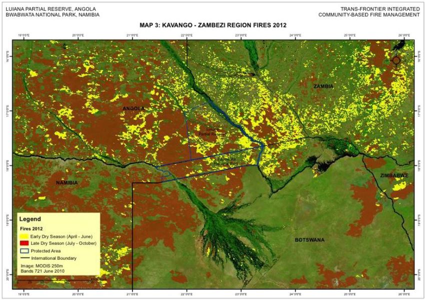
Table of Contents
Table of Contents..................................................................................................................................................................... 3
Acronyms ................................................................................................................................................................................... 4
Acknowledgments ................................................................................................................................................................... 5
Executive Summary ................................................................................................................................................................ 5
1.      Introduction ...................................................................................................................................................................... 0
2.      Vision.................................................................................................................................................................................. 1
3.      Policy, legal and planning context ............................................................................................................................ 1
4.      Geographic context ........................................................................................................................................................ 4
5.      Park description ............................................................................................................................................................... 5
  5.1. Management ................................................................................................................................. 5
  5.2. Socioeconomic overview ............................................................................................................. 6
  5.3. Infrastructure overview .............................................................................................................. 10
  5.4. Ecological overview ................................................................................................................... 11
     5.4.1. Natural habitats ................................................................................................................... 11
     5.4.2. Wildlife ............................................................................................................................... 18
  5.5. Sensitivity and zonation ............................................................................................................ 20
6. Management priorities: Ecological .........................................................................................................................21
  6.1. Controlling fires ......................................................................................................................... 21
  6.2. Combatting poaching and illegal logging ................................................................................. 23
  6.3. Improving connectivity with neighbouring conservation areas................................................ 26
  6.4. Reducing human-wildlife conflicts ........................................................................................... 27
  6.5. Improving knowledge about biodiversity in the park ............................................................... 28
7. Management priorities: Institutional and development ...................................................................................28
  7.1. Clarifying staff structures, job descriptions and performance indicators ................................. 28
  7.2. Developing partnerships with local communities ..................................................................... 29
  7.3. Raising awareness about the park among residents and authorities ......................................... 29
  7.4. Developing park-specific regulations ....................................................................................... 30
  7.5. Identifying tourism potential and promoting tourism. ............................................................... 31
  7.6. Enabling tourism development through improved infrastructure. ............................................. 31
8. Bibliography ...................................................................................................................................................................33
9.      Appendix A: Stakeholders consulted .....................................................................................................................34

                                                                                               3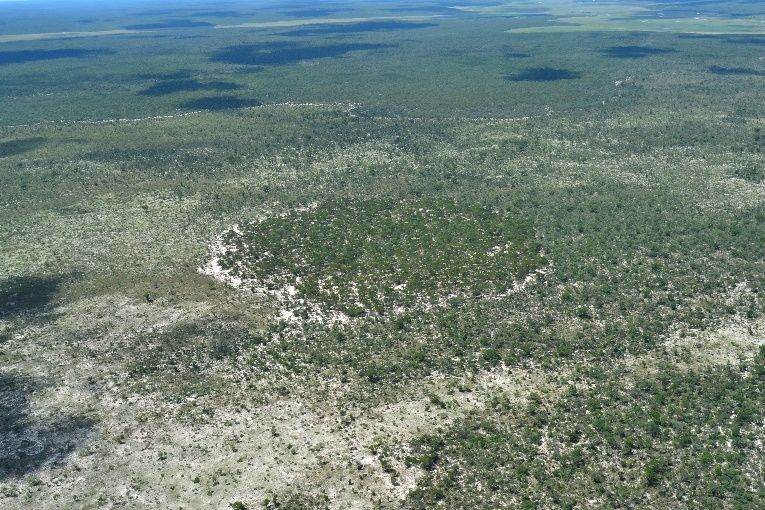
Acronyms

ACADIR - Associação de Conservaçãodo Ambiente e Desenvolvimento Integrado Rural

CBFiM - Community-Based Fire Management

CBNRM - Community-based Natural Resource Management

IFM – Integrated Fire Management

INBAC - National Institute for Biodiversity and Conservation Areas

IRDNC Integrated Rural Development and Nature Conservation

KAZA-TFCA - Kavango Zambezi – Transfrontier Conservation Area

MET - Ministry of Environment and Tourism, Namibia

MINUA - Ministry of Urban Affairs and Environment, Angola

MP – Management Plan

NP - National Park

NGO -Non-Government Organization

PAs - Protected Areas

SADC - Southern African Development Community

TFCA - Transfrontier Conservation Area Programme

                                                 4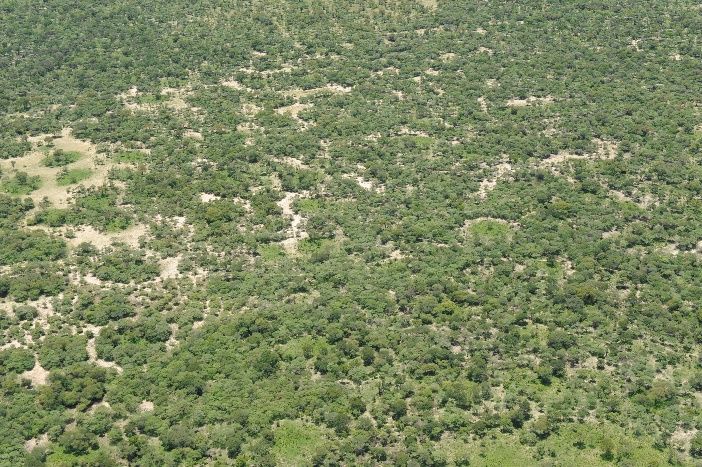
Acknowledgments

We thank Dr Chris Brooks for support, advice and guidance throughout this consultancy, and SAREP
for funding this work. Dr John Mendelsohn and Ms Steffi Mendelsohn are achnowledged for their
technical input, especially information on habitats, infrastructure, ecosystem functioning, land use and
tourism in the two parks, as well as the production of maps. Mr Vladdy Russo and Mr Abias Huongo
are acknowledged for their input on institutional arrangements, Mr Fidi Alpers from IRDNC is thanked
for input on fire management, CBNRM and transboundary matters, and Ms Karen Nott of IRDNC is
thanked for input on logging and indigenous natural products. ACADIR is thanked for conducting field
consultations. Lastly, we thank all stakeholders who attending the various consultative meetings.

Executive Summary

This Management Plan (MP) for the Luengue-Luiana National Park sets out the vision and guidelines
for the management of the park. As such, it represents the intentions of the Ministry of Environment,
and their implementing agency the National Institute for Biodiversity and Conservation Areas
(INBAC).

The MP must be implemented in an efficient and systematic way. For each annual cycle, an Annual
Work plan and a Budget should be prepared. This work plan will, as far as practical, reflect on the
priority management actions outlined in the Plan. The work plan should cover:
    • Routine management issues, such as developing and nurtering relationships with local
         communities living inside the park, and counterparts in neighbouring countries, anti-poaching
         and combatting of illegal logging, fire prevention and fighting, managing human-wildlife
         conflicts, extension work, etc.
    • Development issues, such as removing landmines, creating wildlife corridors, erectings signs at
         strategic locations informing people that they are entering a park, creation of firebreaks,
         maintenance of roads, initiation of tourism opportunities, construction of staff accommodation
         and offices, etc.
    • Monitoring activities, to collect, store, analyse and interpret information for adaptive
         management, covering such things as key biodiversity indicators, contravention of laws,
         growth/shifting of settlements and land use, occurrence of fires, industrial impacts (e.g. mining
         and irrigated agriculture), etc.
    • Research needs based on the identification of priority information and knowledge gaps, with
         appropriate ways of implementing such research.
    • Administration, including work plan & budget preparation, reporting and meetings.

INBAC park staff are ultimately responsible for ensuring that the plan is implemented in effective and
efficient ways, and that the regulations are enforced. They are also responsible for ensuring effective
day-to-day management, dynamic, responsive and pro-active rolling planning as well as contributing to
longer-term planning. It is recommended that the Angolan government considers obtaining some
technical support from a professional organisation to help establish robust management systems in the
park, at least for the first few years. This Plan (2016-2020) should be thoroughly reviewed and, where
necessary, revised every five years. The next review must be done in 2020 for implementation in 2021.

The Plan must be viewed as a valuable and central document by all management and policy-level staff
and stakeholders involved with the park. They should be familiar with its contents, and should make use
of it to familiarize new staff with the vision and management actions.

It is part of every staff member’s job and stakeholder’s responsibility to help implement this plan. It is
also every staff member and stakeholder’s responsibility to propose improvements to the plan, as well
as improvements in how the plan is implemented. Park management is a team effort that cuts across all

                                                     5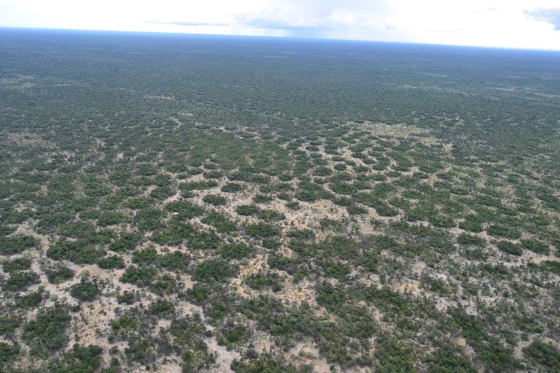
sectors. The future well-being and development of the Luengue-Luiana National Park depends on this
team approach.

………………………………… at ……… on day…… month……………..……. Year………
Director: Ministry of Environment

Name: ………………………………………………………..

………………………………… at ……… on day…… month……………..……. Year………
Director General: INBAC

Name: ………………………………………………………..

………………………………… at ……… on day…… month……………..……. Year………
Governor: Kuando Kubango Province

Name: ………………………………………………………..

At the end of each annual cycle, an Annual Report and Financial Report needs to be prepared, plus a
draft work plan and budget for the following year (see diagram below for schematic illustration). The
Annual Report must include cumulative (time-series) information from the monitoring programme. The
cumulative information, showing trends over time, will be used to adaptively manage the park. This
information will also be used to prepare the next Annual Work Plan and Budget.
1.!     Introduction
In 2011, the Republic of Angola proclaimed two new National Parks within Kuando Kubango
Province; Mavinga (46,076 km2) and Luengue-Luiana (22,610 km2). The Parks were created
in recognition of the areas’ high ecological and biological value. In accordance with the
government’s need to ensure that future development within the region is managed for
sustainability, each park will have its own Management Plan (MP).

This MP for Luengue-Luiana focuses on key management and development issues with a
short-term perspective of 5 years, detailing the objectives, strategies and principles upon
which to manage the Park.

                      Definition of a Protected Area Management Plan;
    “a document that sets forth the basic and development philosophy of the park and
      provides strategies for solving problems and achieving identified management
   objectives over a defined period. Based on these strategies, programmes, actions and
  support facilities necessary for efficient park operations, visitor use and human benefit
    are identified. Throughout the planning effort, the park is considered in a regional
         context that influences and is influenced by it” (Young and Young 1993).

Park specific objectives are defined with clear, realistic action plans that encourage results-
oriented management that respond to specific threats. To ensure that these plans are
effectively implemented, a basic monitoring process is included for measuring the successful
implementation of the plan and achievement of results.

The MP outlines the key ecological features of the protected area, bringing together the
known ecological and biological baseline information upon which to inform and guide
appropriate management recommendations and, where relevant, informing the need for
additional monitoring data and more specific research data.

Proposed management actions relate to existing and anticipated future socio-ecological
threats that may undermine the objectives of the Park. They also relate to the transboundary
importance of these parks for wildlife migrations and international conservation strategies.

Management measures proposed in this MP are flexible enough to deal with future
uncertainties and/or unintended consequences. Management must therefore be adaptive, and
include positive and negative feedback loops.

This MP is a framework for the initial stages of park management. It is a transitional plan: the
“starting blocks” for the management team. The plan should be improved and modified over
time. It must be a living document that grows through experience.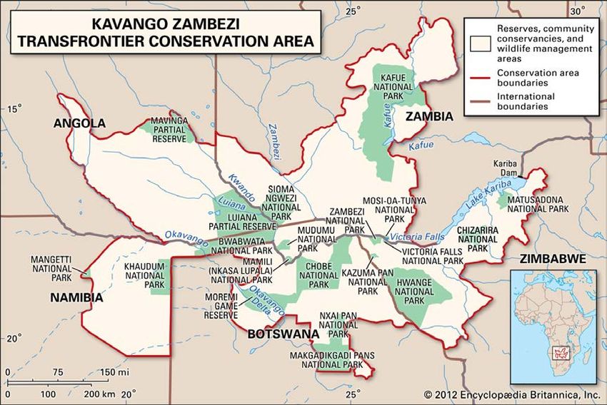
2.      Vision
The objectives of the new parks were defined within the National Assembly Decree (No.
38/11 29th December) and stated as follows;
    • Protect the ecological integrity of the ecosystems and eco-region of Southeast
       Angola;
    • Protect the ecological integrity of one or more ecosystems, biotic community,
       resources genetic and species;
    • To protect and maintain the natural state of the areas, while preserving their rich
       natural, geological and archaeological heritage, and recognising their national and
       international importance;
    • Conserving wildlife, vegetation and other environmental components of the Parks to
       ensure the current and future generations have the opportunity to know and enjoy the
       exemplary representative ecosystems, biotic communities, and biodiversity in
       general;
    • Promote the development of eco-tourism areas allocated to the Parks, contributing to
       improving the living conditions of the population resident within and peripheral
       around the Parks;
    • Preserving the plant and animal species and their natural habitats, both for its rarity
       and endangered status;
    • Reconstitute and / or recover the animal populations and plants and their habitats;
    • To preserve or restore habitats of migratory wildlife;
    • Provide opportunities for research in general.

Bearing the above in mind, the following vision is proposed:

Luengue-Luiana National Park is a conservation priority because of its wetlands, woodlands,
wildlife, and links with the KAZA TFCA. This park will be managed to improve ecological
 functioning and wildlife populations, and to provide a broad range of ecological services to
                        the people residing therein, as well as visitors.

3. Policy, legal and planning context
The foundation for environmental regulations in Angola is the Environment Framework Act
(No. 5/98 of 19 June 1998), which draws on articles 12 and 24 of the Angolan Constitutional
Law (No. 23/92 of 16 September 1992). Article 12 of the Constitutional Law states, among
other things, that the State shall promote the protection and conservation of natural resources
by guiding the exploitation and use thereof for the benefit of the community as a whole. Two
important provisions of Article 24 are the following:
    • The State shall take the requisite measures to protect the environment and national
         species of flora and fauna throughout the national territory and maintain ecological
         balance.
    • Acts that damage or directly or indirectly jeopardize conservation of the environment
         shall be punishable by law.

The Environment Framework Act (EFA) is administered by the Ministry of Environment. The
EFA defines the general and specific principles of protection, preservation and conservation
of the environment, the promotion of the quality of life and the national use of natural
resources by guiding their exploitation and the development initiatives, which benefit all
Angolans.

                                              1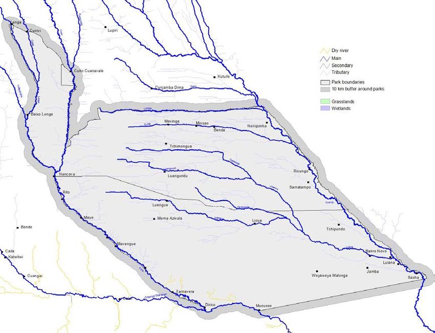
The specific principles for environmental protection, preservation and conservation include,
among other things,
   • recognition of the right to environmental education and training;
   • participation in environmental decision- making and management;
   • precautionary principles;
   • environmental balance towards achieving sustainable development; and
   • the protection and preservation of natural resources, including national genetic
       resources.

Policy and legislation
The Environmental Framework Act (Ministério das Pescas e Ambiente 1999a) stipulates, in
its articles 3/3 and 6, that the State should be responsible for the development and
implementation of a National Environmental Management Plan (Plano Nacional de Gestão
Ambiental – PNGA). This plan, which is still a draft, is seen as an important instrument
guided by the principles of sustainable development. The draft plan gives emphasis to the
need to implement an Environmental Management Strategy (Estratégia Nacional do
Ambiente – ENA) to protect the environment and promote sustainable development.

The establishment of protected areas (national parks, nature reserves and forest reserves) was
first mentioned in a regulation (Regulamento) issued in 1936, and the first protected area
(Parque Nacional de Caça do Iona) was established in 1937. The first statute on nature
conservation and on the establishment of protected areas for different purposes (initially for
hunting and later for nature conservation) was issued on 20 January1955 through Decree No.
40,040 (published in the Official Bulletin on 9 February 1955). It pioneered the establishment
of an institution (Conselho de Protecção à Natureza – Nature Conservation Council)
responsible for controlling the protected areas and developing important legislation for this
effect.

This legislative package included the Hunting Regulations (Regulamento de Caça), Forestry
Regulations (Regulamento Florestal) and National Parks Regulations (Regulamento de
Parques Nacionais). In its annexes, decree No. 40,040 included a list of mammals and bird
species whose hunting was declared illegal.

Some of the above-mentioned legislation was revoked after independence by Decree No.
43/77 of 5 May 1977. This decree also approved the structure of the Ministry of Agriculture
and defined five different categories for protected areas, namely national parks; strict nature
reserves; partial reserves; regional nature parks and special reserves. This categorization does
not cater for issues such as rural community use of wildlife, or the conservation of heritage
sites and important monuments. The decree defines the five categories as set out below:
     1. National Park: An area reserved for the protection, conservation and propagation of
         wild animal life and indigenous vegetation, for the benefit and enjoyment of the
         public.
     2. Strict Nature Reserve: An area for the total protection of wild flora and fauna.
     3. Partial Reserve: An area where it is forbidden to hunt, kill or capture animals, or to
         collect plants, other than for authorized scientific or management purposes.
     4. Regional Nature Park: An area reserved for the protection and conservation of nature,
         in which hunting, fishing and the collection or destruction of wild animals or plants
         and the conduct of industrial, commercial or agricultural activities are prohibited or
         placed under limits.

                                               2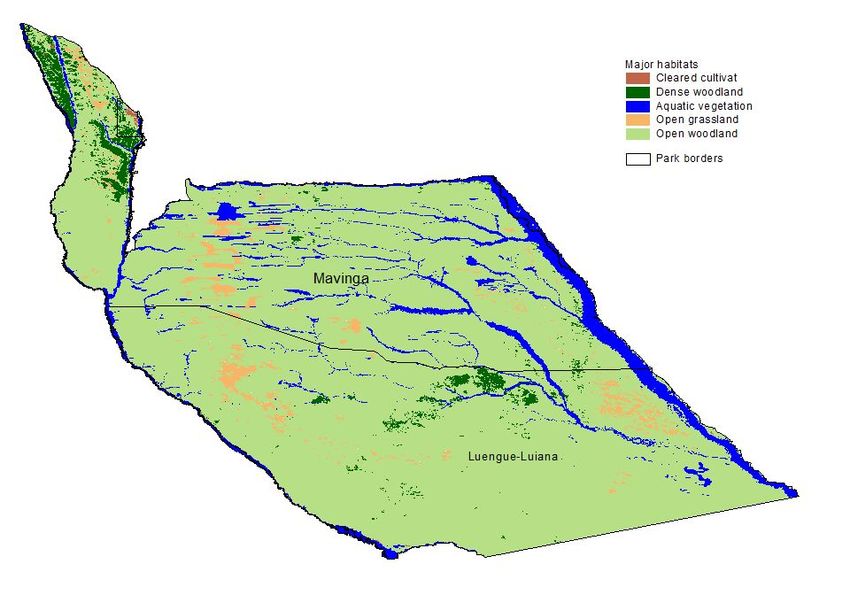
5. Special Reserve: An area where the killing of certain species, whose conservation
       cannot be ensured in any other manner, is prohibited.

In the late 1990s, there were negotiations to transfer the management and protection of
protected areas (excluding agricultural areas) from the Ministry of Agriculture and Rural
Development to the former Ministry of Fisheries and Environment. Although this was agreed
and the structure of the Ministry of Urban Affairs and Environment recognizes that this
ministry should manage all the protected areas in Angola, the protected areas are still being
managed by the Ministry of Agriculture and Rural Development. Currently, it is IDF – the
Forestry Development Institute – located within the Ministry of Agriculture and Rural
Development that oversees the development and enforcement of legislation on protected
areas. IDF was established in 1989 through Decree No. 41/89 of 22 July and works on five
specific areas, namely forestry; wildlife protection; control; administration; and regional
centres.

The Ministry of Agriculture and Rural Development published Despacho No. 204/96 of
November 11, listing the animals whose hunting was prohibited and allowed. This Despacho
was repealed by Combined Executive Decree No. 37/99 of 27 January 1999 (Governo de
Angola 1999) issued by the Ministry of Agriculture and Rural Development and the Ministry
of Finances. This decree provides an updated list of species whose hunting is prohibited and
also those that are allowed.

In terms of forestry, the Decree on Forest Regulation (decree No. 44,531 of 21 August 1962)
was developed during the colonial era. The Ministry of Agriculture and Rural Development
developed the Forestry development licenses (Order No. 149/00 of 7 July 2000), which
established rules on forestry activities and for the conservation of forests. It stipulates that
only entities in possession of licences can undertake forestry activities, and it describes the
process and requirements for the issuing of forestry licences.

The Angolan policy and legal framework does not specifically provide for devolution of
rights over natural resources such as wildlife to local communities. Although the land and
natural resources are controlled by the state, there are however, a number of general
provisions that enable the state to allow the use of land and natural resources by other parties
for various purposes. There is no specific mention though, of using land for wildlife and
tourism. Article 3/1 of the Land Act (No. 9/04 of 9 November 2004) provides for the land
areas (both rural and urban) in which the State has control and rights. These land areas
include that used for agriculture, livestock, forestry, mining, industry, commercial, housing,
rural and urban planning, environmental protection and the combating of soil erosion.

Article 10 states that all natural resources are State property and the State’s rights over the
land are not transmissible. It further notes that the State can determine new rights for the
exploitation of natural resources based on appropriate legislation. Article 14 (b) notes that the
State can intervene in the management and concession of the land affected by the present Act,
in harmony with a number of objectives. An important objective is the protection of the
environment and economically efficient and sustainable use of the land. Article 16/1–2
affirms that the occupation and use of the land depends on a number of norms and standards
for environmental protection, particularly with respect to the protection of landscape, flora
and fauna, the preservation of ecological equilibrium and the right of citizens to a healthy and
non-polluted environment.

Through Decreto Presidencial n.o 10/11, the Government of Angola created the National

                                               3
Institute for Biodiversity and Conservation Areas (INBAC) in 2014. Article 5 of this decree
stipulates (inter alia) the following tasks for INBAC:
• Implement the policies and strategies on biodiversity conservation and the
management of national protected areas;
• Planning of national and cross-border conservation programmes;
• Undertake studies of ecological systems: their composition, structure and functioning;
• Undertake studies to improve the management of genetic heritage, and the
conservation and management of biodiversity;
• Propose the creation of protected areas and ensuring their management;
• Ensure compliance with conservation laws and regulations;
• Ensure that neighbouring communities benefit from conservation areas.
National Assembly Decree (No. 38/11 29th December) proclaimed the Mavinga and Luengue-
Luiana National Parks.
4. Geographic context
The park falls within the Kavango Zambezi (KAZA) Transfrontier Conservation Area
(TFCA), which embraces contiguous parts of southeast Angola, northern Botswana, northeast
Namibia, southwest Zambia, and western Zimbabwe (Figure 1). It contains a mosaic of
protected areas, interspersed with extensive communal lands in which small-scale pastoral
and agro-pastoral land use is practiced.
Figure 1: KAZA Transfrontier Conservation Area
4Apart from localized areas of crop production, mainly for local markets, multi-species
rangeland-based land use systems involving wildlife and livestock have comparative
advantages in the KAZA TFCA. This has been shown from numerous research and analytical
studies in KAZA and around it in similar semi-arid to sub-humid biomes. Economically,
socially, and environmentally sustainable development in KAZA depends largely on
complementary use of rangeland for wildlife and livestock (Barnes 2013).
5. Park description
The ifficial park boundaries as described in National Assembly Decree (No. 38/11 29th
December) are as follows:
North limit: From Macovo river, a direct tributary of the Luangundo river, from its sources
(20º40'19.5"E; 16º28'37"S) until the confluence with the Luangundo river; from downstream
of Luangundo river until the confluence with the Utembo river; , downstream of Utembo river
towards the intersection with the parallel of Nanvu lagoon (21º47'56"E; 16º46'38"S);
following a straight line joining this interception with Geodesic Markings of "Namutui"
(22º19'41"E;16º45'59"S); following a straight line joining the Geodesic Markings of
"Namutui" to the frontier mark n.º 13, in the border between Angola and Zambia
(22º25'18.5"E; 16º44'405''S).
East limit: From the border line between Angola and Zambia towards the frontier mark n.º 14
(22º28'25"E; 16º48'12.5"S) until it reaches the mark of the three borders "Triune"
(23º26'12"E; 17º38'09"S).
South limit: From the border line between Angola and Namibia towards the frontier mark of
the three borders "Triune" (23º26'12"E; 17º38'09"S), up to the mark n.º 10 (22º11'01"E;
17º52'52"S).
West limit: From a straight line joining the mark n.º 10 (22º11'01"E; 17º52'52"S) to the area
of the Havo (21º50'32"E; 17º25'26.5"S); followed by a straight line joining the villages of the
Havo to Wandumbi (21º28'38"E; 17º15'16.5"S); followed by a straight line joining the
Wandumbi location to the springs of Tchissimba (20º51'26"E; 17º16'49.5"S); from the right
tributary of Tondo river towards the course of Tchissimba river, from its source to the
confluence with the river Tondo; downstream of the course of Tondo river, downstream to the
confluence with the Lumuna river; from downstream of the Lumuna river to the confluence
with the Luengue river; from the course of Luengue river, towards upstream of Luengue
village (20º23'19.5"E; 16º44'03"S); followed by a straight line joining the location of
Luengue at the sources of the Macovo river (21º47'58"E; 17º57'14.5" S).
However, according to Russo (pers comm 2016), these boundaries are inaccurate and need
revisiting.
5.1. Management
As noted earlier, park management is the responsibility of the National Institute for
Biodiversity and Conservation Areas. Below is the staff structure for the two parks combined.
The staff current contingent for Luengue-Luiana National Park is 81 rangers, but in future it is
expected that there will be 117. It is recommended that the Angolan government considers
5obtaining some technical support from a professional organisation to help establish robust
management systems in the park, at least for the first few years. In particular, the following
support is regarded as priorities:
•! Anti poaching patrols
•! Establishment of firebreaks
•! Refining the draft fire management strategy presented in this management plan
•! Establishing a viable and sustainable CBNRM approach in the park
•! Establishing a certified Indigenous Products industry (e.g. devils claw).1.
!"#$%$&'()'*(+
!&&$&')%'+ =1$#)'.+=5)%2.+ ;%&7./'*()'.+
!"#$%$&'()'*(+ =*##$&&$*%+ =*##$&&$*%+
!"#$%$&'(),-.+ 3/$.%,4/+(.&.)(/5+ B.)1'5+:+
&.(-$/.&0+)&&.'&+ )%"+#*%$'*($%2+ 367.(-$&*(8+ 9%-$(*%#.%')1+ >*6($&#+:+?6@1$/+ C.'.($%)(8+
3.(-$/.&+ 9"6/),*%+:+ A.1),*%&+3.(-$/.&+
)%"+1*2$&,/&+ 3.(-$/.&+ 3.(-$/.&+
;%'.()/,*%+Figure 3: distribution of people in the two parks
Whilst no systematic or comprehensive sets of data could be assembled on land uses in the
park, a number of features and characteristics are clear.
• The great majority of the area is open rural land.
• Exceptions are urban and peri-urban areas in the sizeable towns and settlements.
• According to Mr Belafonte (Deputy Director in Menongue):
• There are no forest concessions in the park, though there are illicit logging operations.
These are mostly in the southern areas of Cuando Cubango.
• Trees with diameters of less than 20 cm (breast height) are considered firewood
• Logging licences are for 5 years, but are renewable
• Trees may only be harvested between March and September
• The export of Devil’s Claw has been banned by Presidential decree
• Forestry and logging is seen as a way to diversify the econmy
• Although there are many registered loggers and concessions, relatively little logging
actually happens.
• The most successful logging enterprises have foreign partners.
Most of the human population outside of the larger towns is concentrated in small settlements,
with fewer than a hundred people per settlement. Most households practice subsistence
agriculture, in a slash and burn practice. Some households also sell natural resources such as
reeds and thatch grass. Private logging companies extract Baikiaea plurijuga, Burkea
africana, and Pterocarpus angolensis within the area . The following graphs (data gathered
by ACADIR) illustrate a range of resource use patterns as well as human-wildlife conflicts.
7!"#$%&'()%*$&)'"+$&,-&.,//"+$&
!"##$
%&'"(&#"$
)*+,-./."$&'$*+.$
0/1"'$
!"#$%&"'($)*"''%+,-.)/""() !"#$%&'()*+*'(,,#'$&'-,..*/0*#'
(!!" 550 '&($
'(#$
'!!"
'(($ !%"$
&!!"
!&($ !"#$
%!!"
!(($
$!!"
&"$
#!!" &($
10 12
!" ($
)*+" ,-" .,+/*012*3" )$'*+$ '$,$&*+$ -$&*+$ ./01234526$
!"#$%&'#(')*#+',#-&' !"#$%&'()*+",,$-*./*0",-,"1$*
'$ !'$ (&&" 358
#'&" #!#"
#&&"
())$
%'&"
*+,-$ %&&"
!"#$ !'&" 121 !!!" 93
./)0$ !&&" $%"
!&!$ '&"
1+23$ &"
45,637893:$ )*+" ,-" ./+0*123*4"
5"6786"789*":;" 5"-From the above graphs it is clear that the parks provide a great variety of ecosystem services
and these are relied upon extensively by the park inhabitants.
According to IRDNC, Devils Claw harvested in Angola is brought into Namibia to sell
(quantites vary from a few bags to single consignments of up to 6000kgs). The points of entry
have been from Mucusso to Mushangara in the east, through Bwabwata village to the Chetto
buying point and the favoured route through Omega 1.
Studies undertaken by TRAFFIC and IRDNC between 2010 and 2015 indicate that almost all
of the timber being exported from Namibia is from Zambia and Angola. A total of 15 547 m3
of Angolan timber was exported via Namibia between 2010 and 2014. This amount does not
necessarily reflect the total amount actually leaving Angola through Namibia and is likely to
be an underestimate of the true amount.
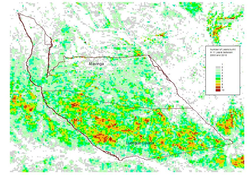
Large areas of the park burn each year2 and evidence suggests that most fires are set by
people, largely between June and September. There are no thunderstorms or lightening during
the above-mentioned months that might cause natural fires. The map below shows the number
of times that an area burnt over a period of 11 years.
2
The data shown here come courtesy of Sally Archibald, and Modis Burnt Area products by David Roy, for the years 2000 to
2010, at 500 metre pixel resolution: http://wamis.meraka.org.za/products/firefrequency-map, and described by: Archibald S,
Scholes R, Roy D, Roberts G & Boschetti L. 2010. Southern African fire regimes as revealed by remote sensing. International
Journal of Wildland Fire 19 (7) 861-878.
9Figure 4: The number of times that an area burnt over a period of 11 years in and
around the two parks.
5.3. Infrastructure overview3
The road network within the park is fairly well developed (figure 5), though many of these
roads are either in poor condition, or inaccessible because of landmines (figure 6).
3
Several road data sources were combined as a basis to develop the roads dataset, these had varying levels of accuracy. Roads
were inspected against Google Earth Landsat imagery, adjusted and improved where possible. In addition, new roads found on
the imagery were digitized and incorporated into the file. Roads have been classified as:
Driven – roads where the source was a GPS driven track, these came from RAISON field work and the 2015 Panthera field
survey in the area. Panthera will survey other areas and roads in the 2 parks between June and December 2016, and that will yield
valuable additional information on useable roads.
Visible – roads that accurately followed tracks that are clearly in satellite imagery but where the ground conditions of the roads is
not known
Inaccurate – where the roads were visible but did not exactly follow tracks on satellite imagery and where the ground conditions
of the road was unknown
Very old or not visible roads – which were not visible or which were visible for a short while but then disappeared
Some roads were also labeled as alternatives, where several dataset had versions or the same track, the best fitting track was
labeled as either driven or visible as above.
Sources: Google Earth satellite imagery, Peace Parks Foundation roads dataset, Panthera field survey driven tracks, RAISON
driven tracks, CNIDA roads dataset.
Air strips:
Lists of air strips, their approximate locations and status for use were provided by Marijn Goud (MAF: Mission Aviation
Fellowship) and Ken O’Connell (MGM – Menschen Gegen Minen).
Services:
Information on the locations of schools, health facilities, police stations and administrative offices in major towns were provided
by Gime Sebastiao (Menongue: Okavango Toursim Project), ACADIR and from personal observations in the field. The
information available is tabulated in an Eccel file: Places and infrastructure.xlsx
10Figure 5: Current network of roads and airfields in the two parks
Figure 6: Current status of landmines4 in the two parks.
5.4. Ecological overview
5.4.1. Natural habitats
Mendelsohn (2016 unpub5) has identified the following five habitats in the two parks: open
woodland, dense woodland, open grassland, aquatic vegetation, and cultivated land (figure 7).
4
Source: Halo Trust 2016
5
Derived from the following sets of data and satellite imagery: classification of LandSat images produced by KAZA,
classification of LandSat images produced by Panthera, classification of forest cover and forest loss produced by Matt Hansen
(see Hansen MC, PV Potapov, R Moore, M Hancher,S A Turubanova, A Tyukavina, D Thau, SV Stehman, SJ Goetz, TR
Loveland, A Kommareddy, A Egorov, L Chini, CO Justice & JRG Townshend. 2013. High-Resolution Global Maps of 21st-
Century Forest Cover Change. Science 342: 850–53.), and Enhanced Vegetation Index (EVI) data sets for 2000 to 2012 from
Africa Soil Information Service: (AfSIS) http://www.africasoils.net/data/datasets?Page=1). Additionally, clear and prominent
areas of floodplains, marshes and open grassland were digitised from images available through Bing and Google Earth.
11Figure 7: Habitats in the two parks
Open woodland covers most of the park, and characteristically consists of fairly widely
spaced trees and limited grass cover. The trees are dominated by Burkea, Baikiaea,
Pterocarpus, and Erythrophleum in the southern areas, whereas Erythropheum, Burkea,
Julbernadia and Guibortia are more dominant towards the northern areas. The spacing of tall
trees varies considerably. Grass cover in most open woodland was sparse, probably as a result
of allelopathy and the underlying sandy substrate that is heavily leached and holds little water.
12Expanse of typical open woodland with its sparse Close-up of open woodland, in this case with
cover of grasses more grass cover than in most areas
Mosaic of patches of grassland and woodland A ‘fairy forest’ surrounded by a margin of bare
collectively forming open woodland habitat ground and open areas dominated largely by
shrubs.
Dense woodland in Luengue-Luiana occurs in large blocks north and south of Liuca and then
as a large separate patch to the west. These areas of dense tree cover perhaps consist largely
of Baikiaea trees. From high resolution satellite images and the aerial survey there appeared
to be a concentration of game trails around these dense woodlands, although the animals may
have been attracted to the broad floodplains of the nearby Luiana River near Licua.
13Dense woodland found in the Licua area adjoining open woodland
Aquatic vegetation flanks all the rivers in the park and some interdune valleys that later feed
into rivers. The greatest expanses are either side of the Cuando River where the inundated
marshlands are generally 10-15 kilometres in breadth. Vegetation is tallest, dense and often
dominated by papyrus close to the river courses and also in their lower reaches. Phragmites,
Miscanthus and other aquatic grasses and sedges are generally found in shallower water
further upstream and away from the river courses. This may reflect a poorer supply of
nutrients in upstream areas and away from flowing water. The Cuito River and its floodplains
support few papyrus or other tall, dense plants because of the extremely low nutrient content
of Cuito water.
14Figure 8: Rivers (above) and rainfall (below) in the two parks.
The perrenial Cuito is deep flowing with clear, open channels. The meandering nature of the
river occasionally cuts into the mainland which then provides a mixed woodland habitat on
the fringe of the main river channel. Small interspersed palm islands (Phoenix reclinata) can
15also be found dotted in the adjacent floodplains of the river. The lower Cuito River is mainly
fed from the upstream catchments of the Cuito and Longa river systems, but a number of
smaller tributaries recharge this lower section of the river downstream of the Longa-Cuito
junction. These smaller tributaries generally feed from the eastern bank of the Cuito where a
gentle escarpment can be found. These feeder channels appear to be seasonal and recharged
by rainfall in the lower catchment of this system. The lower Cuito is also characterised by a
number of rocky rapids which have been formed by protruding rocky outcrops that run across
this river channel. These rapids create partial barriers along the river and offer a unique
aquatic habitat for many species. The Cuito river spills water into adjacent floodplains after
the summer rains. These floodplains are extensive in some parts and increase the size of this
aquatic habitat dramatically. Access into these floodplains is extremely difficult as it is too
vegetated and shallow for a motor boat and access on foot is not safe due to crocodiles and
hippo in the area.
The lower Cuando River is a fairly narrow, slow flowing river lined by Phragmites reeds and
channel fringing emergents. This river “valley” system is a very wide floodplain (up to 5km
wide at some points) that is made up of a number of narrow flowing streams which are likely
to vary in strength and depth as the water levels increase and decrease. The sediment load of
this river is very likely to play a major part in the flow dynamics of these smaller channels.
Access onto the main channel is only possible at a few specific sites where the river channel
cuts into the mainland on western bank. The Cuando River is fed mainly by the Luiana river
system, who’s catchment is in the central part of Angola. A smaller catchment area on the
Zambian side feeds into the Cuando near the village of Luiana. From this point onwards, the
Cuando travels as a single river channel through this very wide floodplain system.
Floodplains along and at the confluence of the The broad swathe of marshlands that form the
Cuito and Longa Rivers Cuando River valley north of Rivungo
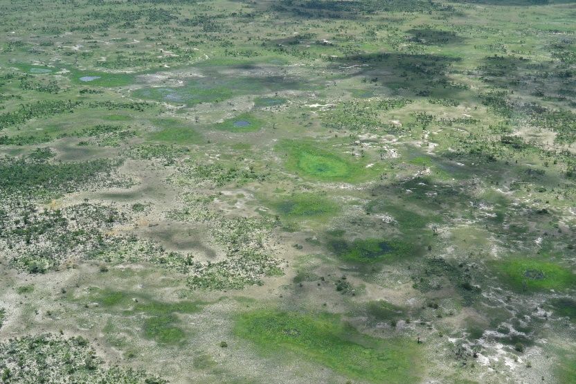
Open grassland areas probably all have a history of inundation during wetter periods.
Hardpans probably underlie all these grasslands which burn regularly. Many grasslands are
indeed still flooded during particularly wet years, and the division between open grasslands
and areas of aquatic vegetation is thus vague in some places. Those areas flooded most
frequently support few trees, unlike patches of more wooded grassland that have seldom been
inundated in recent times.
16Large open grasslands with very little woody Open grasslands that were once an interdune
cover valley but now extensively cultivated
Open grasslands dotted with small pans (green Matrix of grasslands and wooded islands in what
circular patches) and higher areas that support was formerly probably an extensive floodplain
Hyphaene palms and other woody plants
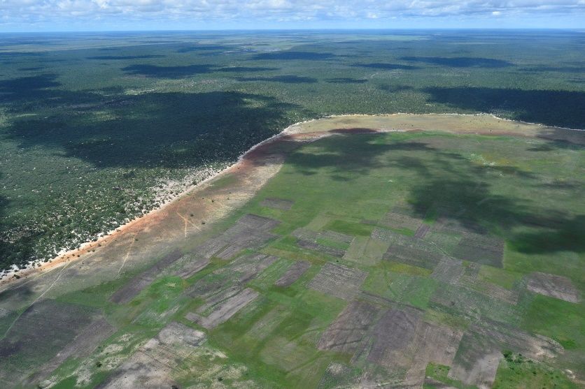
Cultivated land is most prominent in the northern areas of Mavinga National Park between
and around the towns of Longa and Cuito Cuanavale. Many other smaller patches of cleared
woodland were not mapped, mainly because they were not detected by the LandSat
classifications or they were cleared subsequent to those and other images being collected.
Additionally, a great number of fields in floodplains were not mapped. The GIS data is thus
rather inadequate in revealing the extent and distribution of land used for crops. A better
measure of this is provided by the mapping of households and villages.
175.4.2. Wildlife
The three-decades long Angolan Civil War contributed to the serious decline of the once
abundant wildlife communities, particularly larger mammals6. Verissimo (2008) states that
more than 150 species of mammals occurred historically in Kuando Kubango. A 2008 survey
of the previously-named Mucasso Game Reserve (now part of Luengue-Luiana National
Park) confirmed the presence of 39 different species of mammals reported during the survey
in the reserve (Table 1).
Table 1 – List of species confirmed to be present in the Mucusso Game Reserve.
Aardvark - Orycteropus afer
African Buffalo - Syncerus caffer
African Civet - Civettictis civetta
African Elephant - Loxodonta africana
African Wild Cat - Felis lybica
Banded Mongoose - Mungus mungo
Bat-eared Fox - Otocyon megalotis
Bushbuck - Tragelaphus scriptus
Bushpig - Potamochoerus larvatus
Cape Clawless Otter - Aonyx capensis
Caracal - Caracal caracal
Common Duiker - Sylvicapra grimmia
Common Reedbuck - Redunca arundinum
Common Warthog - Phacochoerus africanus
Giraffe - Giraffa camelopardalis
Greater Cane Rat - Thryonomys swinderianus
Greater Kudu - Tragelaphus Tragelaphus
Hippopotamus - Hippopotamus amphibius
Honey Badger - Mellivora capensis
Large Grey Mongoose - Herpestes ichneumon
Lechwe - Kobus leche
Leopard - Panthera pardus
Porcupine - Hystrix africaeaustralis
Roan - Hippotragus equinus
Sable - Hippotragus niger
Scrub Hare - Lepus saxatilis
Serval - Leptailuruss serval
Side-striped Jackal - Canis adustus
Sitatunga - Tragelaphus spekei
Slender Mongoose -Galerella sanguinea
Small-spotted Genet - Genetta genetta
Southern Lesser Galago - Galago moholi
Spotted Hyena - Crocuta crocuta
Spring Hare - Pedetes capensis
Steenbok - Raphicerus campestris
Striped Polecat - Ictonyx striatus
Tree Squirrel - Paraxerus cepapi
Vervet monkey - Cercopithecus aethiops
Wild Dog - Lycaon pictus
6
From a report prepared for USAID by Verissimo 2008
18In addition to this list, the above author reports that additional species that occur in the greater
Kwando-Kubango area include Baboon (Papio ursinus), Blackbacked jackal (Canis
mesomelas), Bat-eared fox (Otocyon megalotis), Aardwolf (Proteles cristatus), Lion
(panthera leo), Cheetah (Acinonyx jubatus), Pangolin (Smutsia temminckii), Plains zebra
(Equus burchellii), Black rhinoceros (Diceros bicornis), Eland (Taurotragus oryx), Oribi
(Ourebia ourebi), Waterbuck (Kobus ellipsiprymnus), and Impala (Aepyceros melampus).
Recent data7 show that large mammals are more abundant in the south-east than elsewhere in
the areas surveyed. Additionally, abundance seems highest close to the Luiana, Okavango and
Cuando Rivers. This is in keeping with observations on soil nutrients, aquatic vegetation
luxuriance and water bird abundance, which suggest that nutrients are more available in the
south and in the lower reaches of these rivers.
Figure 9: Distribution of carivores (left) and herbivores (right) in the two parks
A recent survey found that the
abundance of waterbirds in the
Cuito is low upstream, but much
higher in the lower reaches.
Notably, no piscovorous birds
were recorded in the first 180
kilometers of the river, suggesting
that few fish occur in the upper
reaches of the Cuito River.
All these observations are in
keeping with the general
conclusion that the Cuito (and
other rivers in the Parks) have
extremely low nutrient contents,
and that nutrient levels increase
downstream. The same is true for
suspended solids and other
dissolved materials.
Figure 10: Bird densities in the Cuito river (source:
National Geographic Okavango Expedition, 2015)
7
Data provided by panthera, 2016
195.5.! Sensitivity and zonation
Based on the importance of habitats for biodiversity and the provision of ecological services,
the following zonation is proposed:
Very Important Habitat Zone
Important Habitat Zone
Less Important Habitat Zone
206.! Management priorities: Ecological
Based on literature, stakeholder consultations and expert opinion, the immediate ecological
management priorities are:
•! Controlling fires
•! Combatting poaching and illegal logging
•! Improving connectivity with neighbouring conservation areas
•! Reducing human-wildlife conflicts
•! Stopping the spread of urban and cultivation areas
•! Improving knowledge about biodiversity in the park.
From an institutional and development perspective, the top priorities are:
•! Removing landmines
•! Clarifying staff structures, job descriptions and performance indicators
•! Construction of park entrance gates and the accompanying offices to control entry/exit
•! Construction of staff accommodation, garages, store-rooms etc.8
•! Developing partnerships with local communities
•! Raising awareness about the park among residents and authorities
•! Developing park-specific regulations
•! Identifying tourism potential and initiating an investor conference to attract interest.
6.1.! Controlling fires
Problem statement:
The landscape of Leungue-Luiana NP is characterized as a fire-dependent Savanna. Fires
caused by lightning typically occur during the rainy season, but most of the fires in the park
nowadays occur late in the dry season. This shows that they are purposefully ignited by
humans. This “traditional burning” is used to enhance the subsistence livelihood through
slash-and-burn agriculture, enhancement of grazing (domestic and wildlife), driving wildlife
for hunting, honey gathering, and pest control.
8
The authors of this management plan do not have sufficient knowledge of the park to identify the most efficient location for
staff infrastructure – it is recommended that a workshop be held internally amongst park authorities to prioritise accommodation
requirements.
21Recently, the amount of fire is exceeding the ecosystems’ capability to maintain historic
vegetation species composition and structure, and thus wildlife. This is also likely to lead to
degradation of soil productivity impacting both sustenance for humans and wildlife.
The early season of May-July is when fires generally are low intensity and have a high
probability of self-extinguishment with nighttime humidity recovery because only fine
grasses and herbaceous vegetation burns. From August through October (till the onset of
rains) the dryness of shrub and trees results in large fast moving fires that are very difficult to
extinguish.
An example of early versus late area burned by fire can be found in the map below. With the
yellow areas being early season burning and the red being late season burning. The amount
of late season burning correlates to significant vegetation impacts to human and wildlife
sustenance.
Figure 11: Fires during different seasons in and around the two parks. Source: Beaty, 321Fire.
2014. Integrated Transfrontier Fire Management – A Proposed Approach. Liuana Partial Reserve, Angola & Bwabwata National
Park, Namibia
There is an immediate need to reduce fires. The most efficient means to do this is to institute
a public education and information campaign to influence the timing of burning without
impacting peoples need for burning. Agriculture and honey production burning can be done
after initial onset of rains or literally just as a rain storm is approaching. Dry grasses/ stubble
will burn soon after rain events. Dead grass and herbaceous material is called a “1-hour” fuel
because it generally transitions from full moisture content to dry enough and is available to
burn within approximately 1 hour. Timber over 10 cm is termed a “1000 hour fuel” due to
22the considerable length of time it requires to dry out to be available to burn from being at full
moisture content.
Management actions
Action Who and how When Indicator of success
Establish burning • Park authorities must initiate, but Initiate within See below
seasons supported by local people. year 1, and then
continuous
• November 1 to June 30 is “Open”
(unrestricted) burning;
• July 1 to October 30 is “Closed”
burning. (Subject to permits).
Conduct public Park authorities must take the Initiate within Incidence of fires in
awareness iniative. Traditional leaders and other year 1, and then closed season
campaigns authorities must help. Messages could continuous decreases by 20%
include slogans such as: each year from year
• You can prevent wildfires 2
• Don’t burn during the closed
season -when it’s hot, dry, and
windy.
Communicate these messges via
radio, pamphlets and signboards.
Create firebreaks Utilize existing road networks as fire Start in year 1 200 kms of road
breaks. Reduce shrub/timber fuels (50kms of road), verge “cleared” of
within 10m on each side of the add another 50km bush by 2020
road/track. Park authorities, assisted each year.
by the road maintenance agency, to
do this. Where possible, clear
manually (not with machinery or
chemicals) using local labour.
Transboundary Greater involvement by park Continue with All transboundary
cooperation authorities and community-based existing meetings attended
organisations in the Angola/Namibia arrangements, but by senior staff, and
Cross-Border Fire Management increase feedback given
programme. This can be done in involvement thereafter to all park
partnership between ACADIR gradually. staff and relevant
(Angola) and IRDNC (Namibia). communities.
Also, Integrated Transfrontier Fire
Management should be implemented
– specifically between Leungue-
Luiana NP & Bwabwata NP.
6.2. Combatting poaching and illegal logging
Problem statement:
Poaching over the past 30 years or more has depleted all species of wildlife in the park.
Organized hunting parties poached for meat and to sell Elephant and Hippo ivory and
Rhinoceros horns. Also, the availability of guns and ammunition, and lack of regulation
facilitated hunting by anyone living in the area at that time.
23Poaching still occurs but at much lower intensity, partly because game is now scarce. The
poachers are Angolans, people from neighbouring countries, and some foreigners (non-
Africans). Factors that contribute to the poaching include poverty, lack of law enforcement,
lack of conservation awareness, and permeability of the international border.
The target species poached are primarily medium to large antelopes and buffalo. A lesser
concern is low-intensity hunting by local communities for own consumption, but this should
not be allowed to escalate.
Residents use old weapons, spears, bows and arrows, dogs and traps as hunting tools. Local
hunters also commonly use fire as a hunting tool, either to drive animals out of an area or to
catalyse the growth of new green grass, which attracts animals that are targeted for hunting.
Fire started by hunters often spreads to create vast burned areas, though generating meagre
hunting profits. In general, traditional hunting should not pose a threat to the mammal
populations so long as the human density is low, hunting is not commercialised, and the target
species occur in healthy numbers.
Excessive hunting continues to represent the greatest single threat to many mammal species in
the park, and it must be controlled as a matter of urgency.
Management actions
Action Who and how When Indicator of success
Undertake anti Park authorities must initiate, Initiate within year Incidence of illegal
poaching/illegal but supported by local people. 1, and then hunting and logging
logging law (see next action) and the police. continuous decreases from x in
enforcement 2015 to y by 2020
Arrest and prosecute anyone
involved in illegal commercial
hunting and logging.
Park authority must inform
people (via radio, pamphlets and
signboards) that (1) this is a
park (2) poaching and illegal
logging is prohibited and (3)
transport of bushmeat and
logs/timber/wood originating
from the park, to Namibia or
any other country, is prohibited.
Develop Park authorities must take the Initiate within year 3 formal partnership
partnerships with iniative. 1, and then arrangements in place
local communities, continuous by 2020
particularly those Recognise the value of local
in remote areas knowledge and develop
with wildlife and initiatives which create tangible
forests. benefits to communities in
return for them helping to
conserve wildlife and forests
(learn from Bwabwata
experience)
Improve Angolan wildlife authorities Continue with All KAZA TFCA
transboundary must have greater involvement existing meetings attended by
24You can also read