KERALA Integrated Water Resources Management - 11 December 2018 Paul van Meel Simon Warmerdam - DSS water
←
→
Page content transcription
If your browser does not render page correctly, please read the page content below
KERALA Integrated Water
Resources Management

11 December 2018

Paul van Meel
Simon Warmerdam
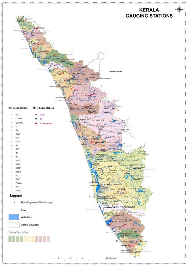
Table of contents                                                            Page

1.    Introduction                                                           1

2.    Summary                                                                2

3.    Kerala Water Resources                                                 3

      3.1     General Setting Kerala Water Resources                         3

      3.2     Observations on the Kerala Water Systems                       6

      3.3     Extreme flooding 15 -17 august 2018; an analysis               8

      3.4     Kerala Water Management                                        11

              3.4.1     Integrated Water Resources Management                11

              3.4.2     Practical concepts for Kerala river basin planning   11

3.5   Kuttanad wetlands                                                      15

4.    Kerala Governance                                                      17

      4.1     Context                                                        17

      4.2     Assessment                                                     18

      4.3     Potential                                                      20

5.    Inter-sectoral linkages                                                22

6.    Recommendations                                                        23

7.    Immediate Follow Up, Cost and Actors                                   25

      7.1     Follow Up                                                      25

      7.2     Cost and Actors                                                25

8.    Methodology                                                            25
1. Introduction
An IWRM mission of 2 experts was mobilized for the period 28 September until 15 October 2018 with the
following purpose.
The Post Disaster Needs Assessment commenced on 17th September and is scheduled to be completed
within a one-month duration. Within the first week of the PDNA, the government requested to have a
specific focus on issues of water conservation, water management and river basin management. This request
comes with an acknowledgement that poor water resources management has contributed to the floods and
landslides in the state leading to high economic losses. The government would like to address some
underlying issues that caused the floods. With this objective, the government has requested the PDNA
assessment team to include an analysis of the water management practices and policies and propose
recommendations to improve the management including conservation of water. The identified nodal
departments for water management are: the Water Resources Department - Kerala Water Authority, and
the Dam Management Authority - Irrigation Department.

The objectives of the assignment were:
Contributing to the overall multi-sectoral objectives of the PDNA, the specific objectives of the Integrated
Water Management Experts team is to:
• Review the water resources management practices under three broad categories: river basin management,
management of water resources for irrigation and water supply, and storage and use of water for electricity
generation;
• Review current policies and measures in place to manage the water resources in the state;
• Undertake an analysis of the causes of the floods and its interlinkages to water resources management,
water needs and spatial planning in the state;
• Provide specific recommendations to improve water resources management practices (water safety, and
water security) including policy framework and governance arrangements for management of water within
the four water entities in the state government;
• Provide solutions based on international best practices for integrated management, monitoring, use and
distribution of water to be implemented in short, medium and long term.

Key Deliverables of the Assignment are a chapter for the PDNA which will include the following.
• An analysis of the recent floods and its technical and governance links to river water, dam water and
    other water resources in the state, including eventual influences from other sectors.
• Recommendations and a range of costed and timed action plans for the establishment of integrated
    water resources management for the state of Kerala with specific actions to be undertaken in the short,
    medium and long term by the four entities which manage water resources in the state

The requested contribution to the PDNA report was submitted as a concise version of this stand alone
report. After final editing of the PDNA report, some suggestions were accommodated in this 12 December
2018 report.

This more elaborate report can be used for future reference for follow up activities. It has 2 major sections
focussing on Kerala water management and governance. Each section describes the context, provides an
assessment as well as the potential to move forward. It provides a separate chapter on inter-sectoral
linkages, followed by recommendations for immediate actions and short, medium- and long-term
interventions. It concludes with the methodology used.

                                                       1
2. Summary

•   In Kerala the concept of Integrated Water Resources Management (IWRM) is not yet adopted in its
    water resources management policies, planning and programmes. If comprehensive IWRM had been
    applied according to international standards, the impact of the floods would definitely have been less.
•   IWRM is about inter-sectoral coordination based on a long-term vision on water. It should be embedded
    in a long-term vision laid down in Kerala’s sustainable development planning.
    With this in place you can make proper plans for water safety and water security based on actual and
    planned land use resulting in multiple basin plans.
•   IWRM plans need to be based on sufficient and reliable data, and state-of-the-art hydrological models.
    Quality is leading; apply concepts like Watershed Management, Room for the River, Living with Water
    and Eco-engineering.
•   Legislation with respect to water is abundant but needs to be made more coherent and more effective.
    International benchmarks may inspire. Consider applying a Water Audit to all interventions.
•   Set up a high-level Kerala State Water Board for coordination between related state departments, with a
    top expert advisory bodyl. The Board is to be supported by a secretariat in a focal ministry.

    Immediate action
•   Promote best practices like Room for the River, Living with Water, and Building with Nature. Build it into
    a communication plan with broadcasting for the general public and narrow casting to specific groups.
•   Start a Hydrological Crash Program. Start collecting available data now. Compare to international
    standards and improve. Parallel set the requirements for the Hydrological software and use that as a
    benchmark for total data collection and verification. Build the hydrological model for a pilot basin.
•   Prepare a master plan for the Kuttanad area. It has the attention of many and was maybe the most
    affected area. All aspects of IWRM are encountered there. Include upstream river basins and the coastal
    zone. Use the lessons learned for replication to other basins.
•   Start an awareness program on Living with Water in flood prone areas at the Panchayat level. Use simple
    manuals and consider monitoring of land use.
•   Change the culture in Kerala to make water part of the hearts and minds of the people. Link this to the
    communication campaign. Set up a Kerala Water Partnership as an independents entity representing the
    public sector, private sector, knowledge institutes and non-governmental organisations (NGOs). It can
    organize the dialogue and the communication, even joint research and development programs
•   Costs for these immediate interventions is almost negligible compared to flood damage and wrong
    decisions on infrastructure investment. Seek financing now.

More recommendations on the short, medium and long term can be found in chapter 6.

                                                      2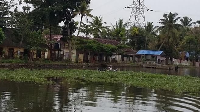
3.        Kerala Water Resources
3.1       General Setting Kerala Water Resources
Note: This report contributes to the Kerala Post Disaster Needs Assessment Report. For readability as a
standalone report it includes general descriptions of the physical conditions of Kerala which may be a
repetition of other chapters of the PDNA Report. Descriptions are taken from earlier reports notably WB/ADB
Joint Rapid Damage and Needs Assessment: Kerala Floods and Landslides 2018, September 2018 and CWC
Study Report Kerala Floods of August 2018, September 2018 and open sources. The data presented in the
WB/ADB and CWC reports are the main basis used in the assessment, analysis and resulting
recommendations. This report reviews the above information and adds observations, assessments and
suggestions of the PDNA IWRM Team.

Below the general setting of Kerala is presented on issues related to Water Management. Apart from the
general descriptions on the geography and climate some elaboration given to features such as climate
change, salt intrusion and the coastal zone.

Geographical setting

Kerala, a southwestern coastal state of India, is flanked by the Arabian Sea on the west and the Western
Ghats mountains on the east. The state stretches north-south along a coastline of 590 km with a varying
width of 35 to 120 km. The terrain divides the State east through west into three distinct regions- hills and
valleys, midland and plains and coastal region. The eastern edge, close to the Ghats, comprises steep
mountains and deep valleys, covered with dense forests. The rapidly falling terrain, heavy precipitation and
the narrow width of the state have given rise to numerous rivers. There are 44 rivers in the state, of which
41 originate from the Western Ghats and flow towards the west into the Arabian Sea. Only three tributaries
of the river Cauvery originate in Kerala and flow east into the neighbouring States.

One of the striking features of the state is the continuous chain of lagoons or backwaters (kayals) existing
along the coastal region. The lagoons or backwaters are connected to the sea through small openings called
Azhis or Pozhis with respectively the opening being permanent or temporary. Canals link the lakes and
backwaters to facilitate an uninterrupted inland water navigation system from Thiruvananthapuram to
Vadakara over a distance of 450 km. The best-known backwater system in Kerala is Kuttanad with large
patches of cultivated areas below sea-level. The Veli Fresh water lake system is also a unique and a
vulnerable ecosystem in the state. Similar inland freshwater bodies are common in the central and southern
parts of Kerala.

Climate

The climate of Kerala is tropical monsoon with seasonally excessive rainfall and hot summers. The state is
having four seasons. The period of March to the end of May is the hot season. This is followed by the South
West Monsoon season that continues till the end of September. From October to December is the North
East Monsoon season and the months of January and February constitute the Winter season. The climate in
the state is pleasant from September to February and the summer months of March to May are
uncomfortable due to high temperature and humidity. The state is extremely humid due to the existence of
the Arabian Sea in the west of it. The total annual rainfall in the state varies from 360 cm over the most
northern parts to about 180 cm in the southern parts. The southwest monsoon is the principal rainy season
when the state receives about 70-80 % of its annual rainfall.

                                                      3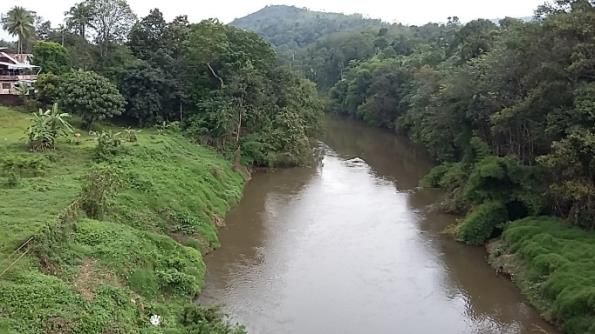
4
The high intensity monsoon storms result in severe floods and heavy discharges in all the rivers. These floods
are becoming more frequent and severe and are now the most common natural hazard in Kerala. Increasing
    flood plain occupancy and reclamation of water bodies and wetlands, less room for water, results in
     increasing flood damages. Riverine flooding is recurring consequent to heavy or continuous rainfall
 exceeding the absorptive capacity of soil and water bodies. The July 1924 floods caused by the south-west
   monsoon caused unprecedented flooding and loss. These floods were unusually heavy in precipitation,
        duration and geographic extent affecting the entire state from June end till August beginning.

Climate change (Ref: Kerala State Action Plan on Climate Change, August 2014)

In the first report on “Impact of climate change in four regions of the country” submitted to the Government
of India by the Indian Network for Climate Change Assessment (INCCA) has been pointed out that reduced
rainfall, increased atmospheric temperature and flooding due to sea level rise are the climate change
scenarios for the Western Ghats and Kerala in the next 20 years. Under the projected climate change
scenario, it is certain that the temperature is likely to increase by 2°C by 2050. The number of rainy days is
likely to decrease along the entire Western Coast, including the Western Ghats.

In the Asia specific Observations based on IPCC Fifth assessment AR5 report it is stated that the frequency of
heavy rainfall events is increasing and increase in precipitation extremes due to monsoon are very likely.
Consequently, this will increase the magnitude and frequency of river floods.

It is now established that the sea level is on the rise due to global warming and the projected Sea Level Rise
(SLR) along Kerala coast on a conservative estimation is about 100 to 200 mm over the next 100 years.
Vulnerability to Sea Level Rise would affect the majority of coastal communities which live on sandy coasts,
most of which are barrier beaches or spits. Backwater banks, islands, filtration ponds, and paddy fields are
other sections of the coastal zone which are highly susceptible to Sea Level Rise.

Coastal Zone

The Coastal Zone in Kerala is the low land fringing the sea extending over 590 kilometres, with a height of
less than 8m above main sea level. To protect the inland, seawalls are constructed over a length of about
340 kilometres.

The coast is prone to erosion. A recent study, National Assessment of Shoreline Changes along Indian coast,
August 2018, prepared by the National Centre for Coastal Research has revealed that Kerala has lost almost
half of its coastline to the sea in the past quarter of a century. Tidal activity and construction including
dredging engulfed over 40 per cent of the coast. At the same time over 21 per cent of the Kerala coast has
been recovered by accretion of fresh deposits. This seems to indicate that the coast is seeking a new natural
balance to adjust to changing conditions such as human interventions.

Tidal fluctuation is different along the Kerala coast. The largest known tidal range at Kochi is 2.14 m and for
Trivandrum this is 0.99 m. The Kerala coast is also vulnerable to tsunami surges.

Salt water intrusion

The short, fast-flowing, monsoon-fed rivers of Kerala often encounter salinity intrusion into their lower
stretches during the summer months. When the fresh water flow reduces, two major problems are
encountered in these water bodies: (i) salinity propagates more into the interior of the river and (ii) the
flushing of the system becomes less effective. Both these aspects have an impact on irrigation, drinking and
industrial water supply schemes, fisheries and the ecosystem situated in the downstream reaches.

                                                       5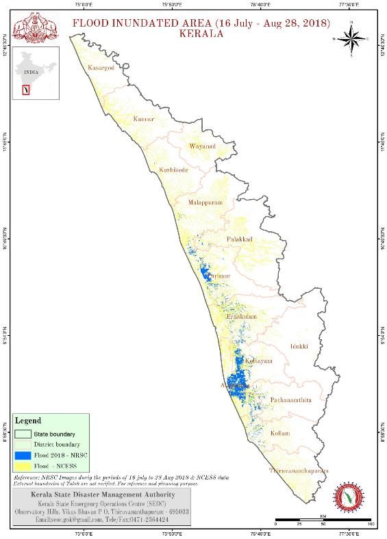
The present measures for preventing salinity intrusion into the intake points of drinking water supply
schemes is by the construction of temporary barrages, which prevent the flow and create ecological
problems, especially concentration of pollutants upstream of the obstruction. Areas upstream of
Thanneermukkom barrage in the Vembanad and Pathalam barrage in the Periyar are typical examples. (Ref:
Environmental Analysis Report for Kerala Rural Water Supply and Sanitation (KRWSS) Project May 30, 2000)

Water Resources Development

The State has developed important water resources and irrigation systems to support various uses of water
throughout the year including agriculture, domestic use, fisheries, and river transport. There are 76 dams in
the State excluding 4 dams in Kerala that are managed by Tamil Nadu, and over 18,000 ponds in the state
which have a combined storage capacity of 5.8 BCM. Seven of the large dams have a combined storage of
74% of the total live storage. Idukki is the largest dam with 1.46 BCM storage. Kerala State Electricity Board
(KSEB) operates 58 dams with hydropower facilities and the Water Resources Department owns 16 dams for
irrigating ayacut areas (ayacut: area served by an irrigation project such as a canal, dam or a tank) of 5,670
km2, and 2 dams are owned by Kerala Water Authority.

In support of planning, design and implementation of water resources development projects the Kerala State
Irrigation Department has a dedicated and professional organization. Basic data on river characteristics,
hydrology, GIS, etc. are the domain of the Irrigation Design and Research Board of the Irrigation Department.

3.2     Observations on the Kerala Water Systems
During a two-day field visit insight was gained on various aspects of the Kerala water systems. It is based on
observations made, discussions with government and other experts and people in the field.

The itinerary included the upper reach of the Pamba River up to the Kochandy Forest Check Post on the
Pamba River, reportedly about 40 kilometres downstream from the Kakki Reservoir. Also, observations of
the Pamba river were made at Vadasserikara and the Kalladayar River at Enath near Kottarakara). At
Chengannur the middle reach of Pamba was observed at Kallisery Bridge and adjacent locations where
flooding occurred. The lower part was visited at Thottapally.

The Periyar was visited near Mattupuram at the location where flooding occurred as well at Mangalapuzha
and Mathanda Varma (Aluva) Bridges.

Also, the Kuttanad backwater area was explored by boat to obtain insight in the below sea level paddy
cultivation and water management. The trip on the main canals encircled the Meenappally Kayal.

In addition to the field visits, meetings were held at various state government departments where
professional opinions where discussed with high level officers and experts.

The following general observations are noted:

Looking at Kerala from the air or driving through it is most striking that urbanisation is everywhere even in
the hilly areas where many scattered houses are seen. Reportedly less land is being used for low yield
agriculture. Emphasis has changed to cash crops and rubber and other plantations. In the context of soil
conservation and erosion protection this land use phenomena will require due consideration.

                                                       6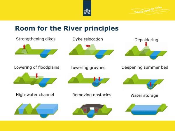
• The upper watersheds of the rivers do not show heavy erosion as large parts are covered by national
parks and forest reserves as is the case with the upstream catchment of the Pamba River. The situation is
better in the southern part than in the northern part of the state where larger patches of eroded slopes
can be observed from Google Maps. Careful preservation and restoration of the upper catchment areas
is an issue also in view of heavy urbanisation of Kerala. This is particularly true for hills where, due to
heavy runoff, the top soil is eroded and much of the natural capacity to absorb rainwater was lost.
• The rivers observed have clearly delineated main channels. The embankments are steep and stable to a
degree. It seems the rivers are stable within their bed. The full bank capacity of the rivers is, based on
discussion and observation, in the order of a 1 in 10
to 25 year maximum discharge depending on the
local topography. Flooding occurs with any higher
river discharges. People seem to live with limited
flooding, live with water, but were not prepared for
an extreme flood as occurred in 1924 and 2018. This
observation is relevant in planning for future flood
mitigating measures with the objective of lowering
the flood levels along the principles of “Room for the
River”.
• Regular flooding occurs in the low areas around the backwaters and lower river reaches. Apart from the
flood discharge inflow from the rivers the reason for flooding is in particular the poor discharge
capacities or blockage of discharge at the sea outlets (Azhis and Pozhis).
• Reportedly at many locations in the rivers cross- and check dams, both permanent and temporary, are
constructed for irrigation or water supply intake. These dams are constructed without giving regard to
the resulting obstruction of higher discharge and thus increasing river levels upstream which may cause
unwanted flooding.
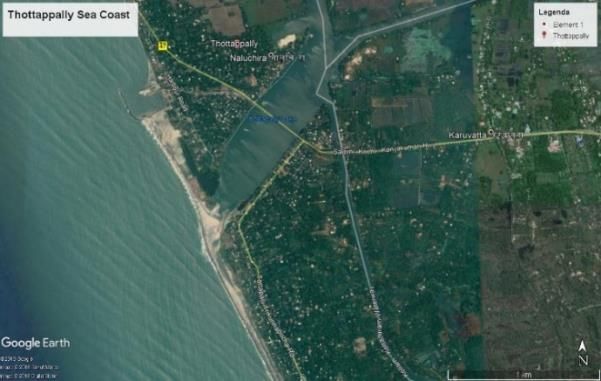
• The drainage channel system of the
Kuttanad area including the main drain into
which the four main rivers drain into the
Kuttanad wetlands have poor maintenance and
have to some extent silted up thus reducing
their drainage discharge capacities towards the
Thottappally Spillway which itself has a limited
capacity of reportedly 380 m3/s.
7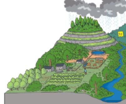
•        Manmade interventions along the coast
                                                             such as creating small harbours by building out
                                                             breakwaters have detrimental effects on the natural
                                                             coast line. E.g. the Thottappally Fishing Harbour
                                                             break water configuration may be the cause of
                                                             silting up of the sea outlet at Thottappally and thus
                                                             hampering the outflow capacity.

                                                             •       Kerala has a well-established hydrometric
      network but it is not fully operational and reliable. The quality of the data can, reportedly, not always be
      guaranteed. Reliable topographical, hydrometric and bathymetric data are a pre-requisite for proper
      planning and designing of water resources development interventions as well as for the operational
      management of the infrastructure such as flood forecasting and preparation of dam operation protocols.

•     The concept of Integrated Water Resources Management is generally known but not adopted mainly
      due to institutional constraints.

3.3       Extreme flooding 15 – 17 August 2018; an analysis
Kerala experienced an abnormally high rainfall from 1 June 2018 to 19 August 2018. This rainfall was about
42% above the normal. Further, the rainfall over Kerala during June, July and 1st to the 19th of August was
15%, 18% and 164% respectively, above normal. It was the worst flooding in Kerala in nearly a century.
Thirty-five dams across the state were opened to release flood runoff. All five overflow gates of the Idukki Dam
were opened, for the first time in 26 years. Heavy rains in Wayanad and Idukki Districts caused severe
landslides.
Water levels in several reservoirs were almost near their capacity due to continuous rainfall from 1st June. Due
to heavy rainfall, the first onset of flooding occurred towards the end of July. Severe rainfall was experienced
at several places from 8-9 August. Another severe spell of rainfall started from 14th August and continued till
19th August, resulting in disastrous flooding in 13 out of 14 districts. As per the IMD, it has been found that the
rainfall depths recorded during the 15-17, August 2018 were comparable to the severe storm that occurred in
the year 1924.
Due to this high rainfall there was an absence of appreciable storage in reservoirs upstream, along with the
shrinkage of carrying capacity of lakes, rivers, and porous land. The limited capacity of Vembanad Lake and
Thottappally spillway worsened the flooding in the Kuttanad region and the backwaters. Many areas were
under water for more than two weeks. (Ref: JRDNA WB/ADB)

The above analysis gives in general terms a good analysis of the effects on the Kerala water systems in response
to the extreme rainfall of 15 – 17 August as climax to a preceding period of heavy rains throughout June, July
and particularly the first weeks of August. Of the total rainfall in the this 20 - 25 % came down in the three
days from 15 – 17 August.

The CWC report on the Kerala Floods of August 2018 gives a thorough hydrological analysis of the effects of
the heavy rainfall on the Periyar, Pamba, combined Pamba – Manimala – Meenachil – Achenkovil all draining
into the Kuttanad wetlands, Chalakudi, Bharathepuzha and the Kabini basins. Reference can be made to this
report for detailed insight.

                                                         8
Based on the CWC report an analysis of the flood disaster is presented with focus on the Bharathepuzha,
Chalakudy and Periyar rivers and the Kuttanad water body with inflow from the Muvattupuzha, Meenachil,
Manimala, Pamba and Achenkovil rivers.
The Flood Inundation Map (Figure 5 of the WB/ADB JRDNA
report) shows that the majority of the flooded area
occurred in the areas around the backwaters and the lower
reaches of the rivers where river bank heights were lower
and adjacent flat areas became water logged with
exceptional levels up to 1 – 2 metres.
In the middle and upper reaches water logging was less
although damage has occurred where strong currents and
flood discharges, in excess of full bank flow, surprised the
people and damaged housing, trees and crops close to the
river banks.
With respect to the outflow from the Malampuzha dam it is
stated that that “during 8-9, August 2018 the total inflow
into the reservoir was about 97 MCM against the release of
48 MCM. During 8-9, August 2018, the reservoir absorbed
about 49 MCM of flood water and thus resulting less
flooding in downstream area. During 15-17, August 2018
the total inflow into the reservoir was about 53 MCM
against the release of 66 MCM, hence the released volume
was about 13 MCM more than the inflow, which is
insignificant in comparison to estimated runoff of 1510
MCM from the basin.” This holds true for the flooding in the
lower reach of the Bharathepuzha. This is not directly true
for the discharge at locations immediately downstream
such as Palakkad city which is located close to the dam. Here
the hydrograph at Palakkad should be compared with
outflow from the reservoir to see how dam operation
actually influenced the local flood flow.
Landslides occurred inland from the rivers and are
independent from the high flood levels in the river. They
happened mainly due to soils being soaked and soil piping
and human interventions such as road construction and
housing. Reportedly no major river bank slides occurred confirming the general stability of the river banks. In
the lower reaches of the rivers some bank erosion has been reported but too a limited extend.
The largest areas flooded were those adjacent to the backwaters along the coast. Also, normally flood free
areas within these wetlands were to a large extent flooded. It can be stated, given the extremely heavy rainfall,
flooding of those areas and areas along the lower parts of the river was unavoidable given the characteristics
and the physical condition of the water systems. The outlets to the sea whether natural Azhis and Pozhis or
controlled, such as at the Thottappally Spillway and Thanneermukkam barrage, do not have the capacity to
evacuate the high flood flows from the rivers, as they occurred, into the sea. The excess water gathered in the
low-lying areas. As the flood was exceptional the flood levels were as well and far above as experienced by
the people for the 1/10 to 1/25 year flood events. Along the Kerala coast the situation was aggravated by the
Perigean spring tide, a high tide occurring only three or four times a year, for the period August 11-15, 2018
and sustained strong onshore winds resulting in abnormal high sea levels further hampering river outflow to
the sea.
9As per the CWC report the overall drainage capacity to the sea of the Kuttanad water body is far below the
original capacity of the structures and the drainage canals/rivers draining towards them. Siltation of these
canals together with an overall poor state of maintenance has drastically reduced their capacities. Even with
lesser floods, water logging of built up areas occur although people seem to live with the water and like a small
flood for flushing out the polluted canals.
A proper operation of the major dams in the upper catchments of the Periya, Chalakudy and Pamba rivers
respectively the Idukki, Mallaperiyar, Parambikulam and Kakki dams would have had only a minimal add-on
effect on the flood levels in their lower reaches and the backwaters and on the duration of waterlogging. Of
course, protocols should be adhered to and not only include operational rules for optimizing power
generation, irrigation supply and safe guarding of the dam but include operational rules for downstream flood
protection when heavy rains occur and environmental flow during periods of drought. Optimizing dam
releases for downstream flood protection will in any case allow for alleviation of extreme peak flows
immediately downstream of the dam and thus reduce damages caused. Controlled releases from the dams,
being located hundred plus kilometres upstream from the wetlands, will have little effect on the flood levels
in the lower reaches especially when the sea outflow is hampered.
Small reservoirs will always have some flood shaving effect. The larger the reservoir capacity, as compared to
the flood volume from the reservoir’s upper catchment, flood control operational rules become more effective
for the downstream reaches.
Increased bed resistance in the rivers by blockages in the middle and upper reaches by check dams, bunds and
poor maintenance will shave off the peak of the floods and, effectively, slow down the inflow into the
backwater areas providing more time for sea outflow and to some extent reduce the flood levels. The river
obstructions in the middle and upper reaches will give locally increased flood levels. Further analysis may
indicate whether this has caused flood damage at, and upstream of, these locations or was experienced as
manageable. In the latter case no “Room for the River” measures will then be required.
In summary: The accumulation of several simultaneous and unique phenomena resulted in extreme floods.
Extreme rainfall, immediate runoff, low flood storage capacity in the reservoirs, poor drainage capacity of
canals and sea outlets and high spring tides came all together.
3.4 Kerala Water Management
3.4.1 Integrated Water Resources Management
In Kerala the concept of Integrated Water Resources Management (IWRM) and its related concept of
Integrated River Basin Management is well known and appreciated but, as yet, not adopted in its water
resources management policies, planning and programmes.
IWRM emphasises cross-disciplinary coordination of water, land and related resources in a river basin,
watershed or catchment to achieve long-term sustainability. IWRM highlights the importance of ecosystem
function in the long term, and reminds us that an integration of policies, decisions and costs are necessary
across a multitude of sectors.
Integrated Water Resources Management aims to break the inter-sectoral barriers to establish a holistic
framework for coordination. It brings together all stakeholders involved in the use of the river basin
resources and together develop an agreed set of policies and strategies to achieve a balanced approach to
land, water, and natural resource management. It helps us understand that we can find best practice river
management in many activities—from community use, safeguarding the environment, economics, urban
planning or business management. And, it puts the focus back onto achieving healthy river ecosystems with
wide-ranging benefits for all communities, economies and biological processes within it.
10Integrated Water Resources Management has its focus on different uses of interdependent finite water
resources. High irrigation demands and polluted drainage flows from agriculture mean less freshwater for
drinking or industrial use; contaminated municipal and industrial wastewater pollutes rivers and threatens
ecosystems; if water must be left in a river to protect fisheries and ecosystems, less can be diverted to grow
crops. There are plenty more examples of the basic theme that unregulated use of scarce water resources is
wasteful and inherently unsustainable.
In this report recommendations and a range of costed and timed action plans will be presented on the
establishment of integrated water resources planning for the State of Kerala.
3.4.2 Practical concepts for Kerala river basin planning
In the previous chapters the main issues of Kerala’s river basin management are discussed of which the most
pressing are:
• Cross-Sectoral coordination in policy development, planning, and implementation of water related
infrastructure. This issue will be dealt with in Chapter 2 of this report on institutional development.
• Upper catchment soil conservation and erosion protection
• River channel management in view of uncoordinated construction of permanent and temporary check
dams and bunds for irrigation and domestic water supply.
• Poor state of repair of canal embankments (bunds) and silted-up and polluted drainage canals.
• Sub-optimal operational conditions and state of repair of weirs, barrages, and spillways.
• Sub-optimal protocols, and adherence to them, for dam operations without e.g. balanced consideration
for downstream water demand, environmental flow, flood protection, and power generation.
• Poor management of coastal river outlets.
• Sub-optimal polder management in e.g. the Kuttanad area.
• Lack of validated hydrological, bathymetric, topographical, land-use and remote sensing data and related
models.
Due to these issues the river systems do not function well with as a result difficulty in managing irrigation
and domestic water supply during periods of drought, water management of impoldered paddy fields and
kayals and finally increase in flood risks across the basins. As all issues are interrelated the concept of IWRM
needs to be adopted and implemented.
To understand the inter relations, a river basin plan needs to be developed incorporating all above aspects.
In the first instance the plan needs alternative development scenarios to be developed and agreed upon.
From these scenarios a preferred scenario with a long-term vision and related objectives is to be derived
which will need political/administrative support before proceeding with planning. The required detail of the
development scenarios depends on the complexity of the administrative/political discussion. Once a long-
term vision is agreed upon the plan can be worked out and may consist of various interventions for the
short, middle and longer term which together achieve the objectives of the long-term vision.
In carrying out basin planning for Kerala’s rivers use can be made of internationally accepted good practices
and technical concepts. Some of these good practices are elaborated on in the following.
Hydrological Crash Programme
Before embarking on the planning exercise an absolute prerequisite will be a reliable set of data on which to
base the technical components of the Basin Planning, such as hydrological modelling, to improve the
behaviour of the river under different circumstances and to be used in the development of different
scenarios. Without having the data in order no proper calibration of the models can take place: rubbish in
gives rubbish out!
11It is to be considered to immediately embark on a Hydrological Crash Programme in which all relevant data
are collected, digitalized and where needed thoroughly validated. Possibly the National Hydrological
Programme (NHP) can assist and contribute.
The exercise should in the first instance take not more than six months. Parallel, basin modelling can take
place. The developed models can be calibrated once reliable data becomes available. These models will
become decision support tools in which different scenarios or alternative measures can be simulated to
enable fact-based decisions at higher administrative/political levels.
The crash programme should also include a component on data needed for coastal zone management and
engineering.
Integrated Watershed Management in the Hilly area and upper sub-catchments
The upper catchments of the rivers are for certain areas well managed as they are designated forest reserves
or national parks. When this is not the case the
upper watersheds are used for up-hill agriculture,
plantations of rubber trees, pineapples, tea plants,
etc. To ensure good water absorption and water
holding conditions of the upper soil, rigorous soil
conservation, and erosion protection measures
need to be taken.
An international best practice for managing the
smaller upper catchment of rivers and streams is
Integrated Watershed Management (IWM) with
objectives to improve farmer's livelihoods and sustainable estate management to protect the environment
in often highly degraded watersheds in the hilly regions by promoting an integrated and replicable model of
sustainable rural development. Through a participatory design process at panchayat level, activities can be
packaged into an integrated set of interventions. i) Soil and water conservation: physical investments for soil
and water conservation primarily of public interest including minimum capital farmland, sediment retention
structures, afforestation and vegetative cover, and village infrastructure such as water supply facilities. ii)
Livelihood improvement: physical investments designed to improve the income of farmers including
terracing of slope land, horticulture and fruit and nut trees, grasslands, livestock development, irrigation and
drainage and renewable energy supply. iii) Coordination and support services will ensure the participatory
design process with inclusion of vulnerable groups, the quality implementation of activities under the first
two components, the right institutional setting for sustainable operation and maintenance of project
activities, the mitigation of environmental and social risks, and monitoring and evaluation.
Neyyar River Sea Outlet
from Poovar Backwater
12Mitigation of flood risks – ‘Room for the River’
Flood risk management is building on two components to mitigate flood risk damage (Flood risk damage =
Risk of flooding x Resulting damage).
• Ensure absorption and holding of water in the upper catchment areas of the river. This can be
achieved by building multipurpose storage reservoir and adopting IWM as explained above.
• Adopt the principles of ‘Room for the River’. The objective of this principle is to lower flood water
levels in the rivers to reduce the flood risk. The above figure shows the possible interventions to
achieve this objective.
When translating this to Kerala conditions it may involve:
• Strengthening or increasing crest heights of embankments and bunds;
• Outward Shifting of embankments or bunds or digging off river embankments to increase
channel/canal wet areas;
• Removing of lower bunds which protect flood plains to allow free flow through flood plains with as
much as possible clean-up of trees and brushes and removal of housing and sheds;
• Lowering of the flood plains or flat areas next to the river;
• Removal of check dams and cross-bunds and other obstacles;
• Dredging out the river and canal beds;
• Create flood by-pass using already low-lying areas or old river beds e.g. those old river beds used by
the recent flood waters next to the main river channels;
• Create retention areas by linking lakes, irrigation canals or dedicated kayals to temporary store
water.
Preventive damage control is done by having a strict licencing policy for building in flood prone areas which
also needs to be adhered to. As Kerala sees a rapid urbanisation and pressure on availability of building plots
the concept of ‘living with water’ may be adopted for those who accept a calculated risk and build
accordingly.
13The Netherlands ‘Room for the River’ project had as an qually important objective: ecological conservation
and restoration. When planning any intervention, it needs to be accompanied by a proper Environmental
and Social Impact Assessment (EISA) including required mitigating measures to avoid environmental
deterioration. For the Basin Plans this may be at a strategic level (SESIA).
Integrated Coastal Zone Management
ICZM is a dynamic, multidisciplinary and iterative process to promote sustainable management of coastal
zones. ICZM seeks, over the long-term, to balance environmental, economic, social, cultural and recreational
objectives, all within the limits set by natural dynamics. 'Integrated' in ICZM refers to the integration of
objectives and also to the integration of the many instruments needed to meet these objectives. It means
integration of all relevant policy areas, sectors, and levels of administration. It means integration of the
terrestrial and marine components of the target territory, in both time and space. (Definition of ICZM by
European Commission)
On the technical side state of the art morphological models are available to analyse and predict coastal
morphological processes such as coastal erosion or accretion. For Kerala this is relevant in engineering
sustainable sea outlets where needed.
Living with water
In flood prone areas water logging of built-up land cannot always be avoided. As people are under certain
conditions comfortable with this fact, the concept of ‘living with water’ can be adopted in developing long
term vision scenarios for these areas. Apart from technical measures such as building of multi-storeyed
housing to allow a safe place for the household during floods and mounts to where cattle can be evacuated,
soft measures apply such as enhancing awareness of the risks and early warning and communication.
In Kerala living with water is to some extent brought into practice in the Vembanad lake system and
Kuttanad. The encroachments of housing on the bunds can also be looked upon as positive as people
apparently accept the regular flooding, within limits, of their plots; they live with the water. In future
Kuttanad development this feature can be used to try to improve on the conditions to stimulate flood safe
housing (e.g. on poles) and build out mounts from the bunds or reclaim land from the kayals or provide
increased flood safety using higher embankments.
Living with water is also practiced for eco-tourism where houseboats in the kayals are popular holiday
dwellings. Adapted waterfront development on or close to the water may give tourist a living with water
experience.
In living with water, it should be made clear that the people need to accept the risk that extreme flood levels
may, occasionally, occur and housing needs to be adapted to these possible circumstances. Due
consideration needs to be given to the water, sanitation, and hygiene (WASH) aspects in the developments.
Building with nature
Building with nature is a concept where natural phenomena are leveraged to cope with climate change risks,
such as floods, waves and sea-level- rise (SLR). It is also called 'eco-engineering'.
An oyster reef to protect the coast, mangroves or willows in front of the dyke. Slowly but surely, a new insight
is gaining ground: hard civil engineering interventions by themselves are not a panacea. Nature seems willing
to help us to keep the upper hand over the advancing waves and rising sea levels and provides us with new
sources of food and income.
14For Kerala BwN/Eco-engineering could be an option worth studying for coastal protection, bund and
embankment protection against wave attacks from fast tourist boats, natural by-passes in the river to enlarge
the river’s discharge capacity and thus keep flood water levels lower, etc.
Flood risk management
Flood control aims at preventing human casualties and limiting the material damage. Extreme floods cannot
be prevented. Investment in reduction of flood risks is like an insurance premium. The amount of the premium
depends on the risk level one wants to insure against. Flood risk damage = flood risk x flood damage. Areas
with potentially high socio-economic damage could be protected against flood occurrences of once in 50 -100
years (or more), this however at a cost (high premium). Rural areas with few people could receive less
protection with also lower investments (low premium).
3.5 Kuttanad wetlands
The Kuttanad water system was one of the areas most effected by the flood of August 2014. The flooding
occurred mainly in the lower part of the Meenachil basin and the areas southwards toward the lower
reaches of the Pamba river, the Kuttanad wetlands (polder) area and the lands adjacent to the southern part
of the Vembanad lake system. The main reason for the excessive flooding was the limited capacity of the
outflow to the sea. In the various assessments, formal and informal, Kuttanad receives due attention and has
priority to plan for improved water management including flood damage mitigation.
The Kuttanad wetlands extend from the South part of Vembanad lake of which the outflow is controlled by
the Taneermukkum Barrage (main purpose is avoidance of salt intrusion), the polder areas in and adjacent to
the lake and the polder areas south of the lake with as approximate southern boundary the Pamba river and
outlet canal controlled by the Thottappally Spillway (designed for blocking salt water intrusion and
discharging of flood waters).
Kerala’s coastal area is, apart from the climate, in many ways similar to the coastal area of The Netherlands.
Both have a straight coastline running from north to south with (originally) natural sea barriers with levels of
5 – 10 meters above main sea level (msl). In Kerala they constitute of stable deposits with built-on
settlements whilst in the Netherlands there are sand dunes. On the seaside sandy beaches are predominant
which in both situations are prone to coastal erosion. All along and behind the higher coastline one finds
natural backwaters. In Kerala they are called kayal.
The Kuttanad is an impoldered back water used for below msl paddy cultivation. The Vembanad lake system
is the largest kayal. The Kayamkulam Kayal and Ashtamudi Lake are other examples in Kerala. In the
Netherlands most of the backwaters are impoldered to allow for agricultural, urban, and industrial
development. Polder development is characterized by a system of main canals with water levels at
approximately msl or below. The canals typically run within embankments or dikes and are used as buffers
for supply of irrigation water or for pumped water from lower lying polders. In Kuttanad these polders are
mainly paddy fields. The canals also act as drainage for the whole polder system, achieved by free flow
towards the sea or by using pumps.
To gain a quick understanding of the Kuttanad water management as it was around 1990, it is recommended
to look at a film on the Kuttanad Water Balance Study Project which can be found using the following link:
https://youtu.be/Z-wH-EujcTE Kuttanad - Water Balance Study Project (Indo-Dutch). The study presents
recommendations for improvement of the water management of Kuttanad. Only to a very limited extent the
recommendations had a follow up in actual improvement and construction of new water management
infrastructure.
15Since 1990 the situation in the Kuttanad area has drastically changed not alone by encroachment of housing
on the canal bunds which is now everywhere. Canals and water management structures are suffering from
poor maintenance. Any new improvement plan will have to deal with this next to the environmental
deterioration due to fertilisers and pesticides which took place over the years resulting in abundant
uncontrolled growth of water hyacinth. In addition to flood damage mitigation. Tourism, fisheries and
ecological aspects for wetland improvement must be considered.
An important component is coastal zone management with specific coastal engineering for sustained sea
outlets for flood drainage out of the area. Options like Building with Nature may well be applicable. To
improve the water management in Kuttanad a study must be undertaken to plan rehabilitation of the water
system using state-of-the-art concepts in polder development and coastal zone management.
A good starting point would be a review of the Kuttanad Water Balance Study. A prerequisite for any further
study would be the update of existing data and collection of new data on topography, polder infrastructure,
hydrology, coastal bathymetry, and ecology. The methodology and tools developed for Kuttanad as a pilot
area can also be applied in other Kerala river basins.
The methodology and tools developed for Kuttanad as a pilot area, can also be applied in other Kerala river
basins.
CWC Fig.10: Index map of Kuttanad/ Vembanad Lake
164. Kerala Governance
IWRM is considered part and parcel of integrated spatial planning encompassing both urban and rural
development. IWRM planning has to fit into formal spatial plans enacted in law.
4.1 Context
State Government structure
In broad terms the state government comprises of the Governor, Chief Minister, Council of Ministers,
Legislative Assembly and Secretaries (Chief Secretary, Additional Chief Secretaries and Secretaries) heading
20 departments, with some 100 directorates out which some 25 may be considered of immediate relevance
to IWRM. No cross-cutting arrangements were observed.
Besides government departments, the activities of the government of Kerala is spread over several other
government Institutions such as Commissions, Autonomous Bodies, Cultural Institutions, Public Enterprises,
Welfare Fund Boards, Co-operative Organisations, Development Authorities, Universities etc.
In addition, there are 4 missions. The Haritha Keralam is an Umbrella Mission envisages pollution-free water
sources, revival of water sources, water conservation, eco-friendly and sustainable waste management, as
well as enhancing organic farming
There are 1200 local governments in Kerala, which includes 941 Grama Panchayats, 152 Block Panchayats,
14 District Panchayats, 77 Taluks, 87 Municipalities and 6 Municipal Corporations. Kerala's experience with
local self-government has been distinct in three important ways and is more developed than
elsewhere: financial devolution. the part played by local bodies in formulating and implementing Plans and
the extent of people's participation in development planning
The Water Resources Department takes the administrative level decisions of the Line/Subordinate
Departments. Its political head is the Minister and the administrative head is the additional Chief Secretary.
The mission and vision are to ensure that the right of access to water for all citizens is transformed into
reality. This can only be achieved by ensuring that the demands for drinking water, agriculture, power
generation and industry are appropriately addressed in the context of the physical, environmental and social
background of the State. At the same time, to ensure that this vital resource will be sustainable for future
generations to come.
The activities of the Water Resources Department are rooted in the State's Water Policy. A massive exercise
has been launched aiming at strengthening and restructuring of Kerala Water Authority, thereby reorienting
it into a "Customer Friendly" and competitive organization. A priority-based approach is applied for
selection, implementation and commissioning of new projects. Great importance has been attached to the
timely completion of projects.
The department has the following sections:
1. Irrigation Department
2. Kerala Water Authority
3. Ground Water Department
4. Jalanidhi (Rural Water Supply and Sanitation)
5. (Irrigation) Command Area Development Authority (CADA)
6. Kerala Irrigation and Infrastructure Development Corporation
In addition, there are several Agencies such as the Kerala Disaster Management Agency
17At the national level there is the Central Water Commission, which is a premier Technical Organization in the
field of water resources and is presently attached to the Ministry of Water Resources, River Development
and Ganga Rejuvenation. It deals with initiating, coordinating and furthering in consultation with state
governments concerned, schemes for flood control, irrigation, navigation, drinking water supply and water
power development. When required it may undertake investigations, construction and execution of any such
schemes required. It has a regional office in Coimbatore, Tamil Nadu. In Kerala there is no State Water
Commission. most tasks are entrusted to the Department Water Resources and in particular its Irrigation
Department. It is being considered to enhance it’s mandate and become the focal ministry for integrated
water resources management. At least, the willingness is there in some quarters.
A separate observation is that, based on the infrastructures visited, there is a general lack of maintenance,
probably due to the same shortage of funding for O&M as in other sectors, in particular Water Supply &
Sanitation. During extreme events one can not expect the infrastructure to operate at it’s full capacity.
4.2 Assessment
Acceptance of IWRM as cross-cutting is gaining momentum. As Kerala is a federal state with a well-educated
population, it should be able to manage its own resources in an autonomous way. There are only 6 shared
rivers with the State of Tamil Nadu, which are of minor importance and can be dealt with between the 2 states
Kerala has a strong government which gives autonomy to lower levels of government and in particular districts
and panchayats. At the district level the local experts usually deal with operation and maintenance of smaller
schemes.
There is multitude of government entities that one way or another deal with water related activities. They
are not all of the same importance in IWRM. Therefore, we distinguish 3 rings. The 1st ring will deal with IWRM
on a daily basis, the 2nd ring frequently, the 3rd ring occasionally. The Department Water Resources is the
most conversant with IWRM. Immediately related are the Irrigation Department, sections Groundwater and
hydrographic Survey Wing (1st ring). Also related are Agriculture Development and Farmer’s welfare,
Environment and Climate Change, Fisheries, Harbour engineering, Public Works, Mining and Geology, Soil
Survey and Conservation, Surveys and Land Records, Town and Country Planning and Water Transport (2nd
ring). More remotely related are i.e. education, which could be part of a 3rd ring related to IWRM. There are
no obvious coordination arrangements yet between the different directorates, apart from the first ring. Key
persons recognize that this requires action.
The mandates of Department Water Resources and the Department Irrigation currently cover a lot of what is
required for Water Resources Management. On the other hand i.e. the Energy Department manages the dams
for electricity production. For irrigation purposes, the flow of these dams is considered sufficient.
Nevertheless, there is much scope for improved coordination between different sectors, which, to date, is
considered not easy. For a river basin systems approach this cross-sectoral coordination is crucial to optimize
a more robust system. This will require a shift in culture and possibly legislation. On the other hand, well
educated people in the government and civil society have a good grasp of what is required. Also, many laws
and regulations are said to be in place but have not always become effective. There is quite some experience
with local autonomy at the lower levels of government and a well-developed network of Community Service
Organizations to build on. Apparently, there is sufficient absorption capacity for further developing a river
basin systems approach.
18Awareness, capacity building and operationalization. Broadly comparing IWRM in Kerala with reference
countries, there is much still to gained. Awareness and expertise on IWRM and a systems-based approach is
available. But it is limited and scattered and needs to be linked. Knowledge on IWRM is available among senior
government officials and among less senior staff that still have to make a career. Especially the latter needs
to be unlocked. Several key players at the government state level are aware of the importance of IWRM but
do not yet have an overall common understanding. Given the awareness at the top and with individuals lower
in the organization, it should be possible to train people soon to incorporate a common IWRM approach in
their tasks. One could start soon with a 2 day workshop among key stakeholders.
In the private sector and with knowledge institutes there is expertise on IWRM which could well be tapped
into. Also, individuals in civil society understand the importance of IWRM. It was noted that there are different
interpretations of IWRM depending on the sectoral background. It would strengthen cooperation and
partnerships to enhance common understanding of IWRM with coherent and consistent training programs.
Decision making on interventions in the river basins is often based on sectoral priority rather than an overall
integrated plan. Planning is done meticulously but implementation is often missing. The impact on other
stakeholders is not always taken into account. Checks and balances on changing land use may be improved
with inspiration from international practice. Not available is a tool like a Water Audit that can be applied as a
proven effective check on all spatial plans and its amendments as to the impact on the overall water system.
Still to be explored is the potential to tap into the Kerala diaspora. . Contacts with the Kerala community in
the Netherlands, confirm that there is international standard expertise available and committed to
contributing. It is assumed that this expertise and commitment is available in other countries as well and is
worthwhile tapping into.
The relatively new Kerala Disaster Management Agency has proven to be capable of dealing with complex
issues related to IWRM. Staff is aware of and champions the future application of international best practices
for adequate river basin management in Kerala including flood prevention, management and relief. Close
cooperation between the department Water Resources and this Agency, even informal, has the potential to
convince decision makers on immediate steps forward.
Especially districts and panchayats are empowered to a serious level of autonomy. This study has not been
able to verify the local capabilities. There is no doubt about resilience after the disaster, but it appears as
though disaster preparedness was not developed to its full extent. In terms of water management related
issues, tasks are limited to small schemes, operation & maintenance. The capability is doubtful as to how to
deal with IWRM without training and provision of tools. Other PDNA reports and consultation with CSOs reveal
a solid base for local commitment to build on.
Informants point out that there is an abundance of legislation. It is not yet clear to what extent available laws
strengthen one another or are contradicting. According to most informers enforcement remains a big
problem. In particular land use planning, administration and permitting can be a tool to ensure that human
interventions are controlled.
The team was informed about an existing Centre for Water Resources Development and Management , but
it could not be visited to assess its role and effectiveness. It is an autonomous R & D institution in the water
sector established by the Government of Kerala, under its Science and Technology Policy in February 1978.
The Centre was amalgamated with the Kerala State Council for Science, Technology and Environment (KSCSTE)
in its Silver Jubilee Year-2003. The centre has contributed to the scientific hydrologic studies and water
management in the region.
19You can also read