Managing grazing lands in Queensland - June 2011
←
→
Page content transcription
If your browser does not render page correctly, please read the page content below
Managing grazing lands in
Queensland

June 2011
Prepared by:
Science Strategy and Integration
Department of Environment and Resource Management
© The State of Queensland (Department of Environment and Resource Management) 2011

Copyright inquiries should be addressed to copyright@derm.qld.gov.au or the Department of
Environment and Resource Management, 41 George Street Brisbane QLD 4000
Published by the Queensland Government, 2011

This report may be cited as follows:
Department of Environment and Resource Management 2011. Managing grazing lands in Queensland. Queensland Department of
Environment and Resource Management.

This document has been prepared with all due diligence and care, based on the best available information at the time of publication.
The department holds no responsibility for any errors or omissions within this document. Any decisions made by other parties based
on this document are solely the responsibility of those parties. Information contained in this document is from a number of sources
and, as such, does not necessarily represent government or departmental policy.

This publication can be made available in alternative formats (including
large print and audiotape) on request for people with a vision
impairment.
Contact (07) 322 48412 or email
June 2011

#00000
Summary
This publication is a guide to good management practices for grazing lands in Queensland. Its primary
purpose is to assist lessees of rural leasehold land to which the Delbessie Agreement applies. The Delbessie
Agreement is a framework of legislation, policies and guidelines supporting the environmentally sustainable
and productive use of rural leasehold land. This guide will also assist graziers with obligations under the
Reef Protection Policy.
There is no set formula for managing the pastures across such a large and diverse area as the grazing lands of
Queensland, therefore careful consideration needs to be given to how pastures, trees, soils, grazing animals
and climate all interact. This guide contains summarised information from the many sources referred to in
this guide. If more specific information is required about a particular topic, it is recommended that these
sources be consulted.
Experienced graziers will already be well aware of much of the information provided in this publication.
However a number of fundamental issues have been covered for the benefit of other readers who have an
interest in the management of the vast area of grazing lands in Queensland.
The major management issue in grazing systems is managing stock numbers to match the current and
expected seasonal conditions. Graziers need to make regular decisions about how many animals they should
run on a piece of land and the impact of feral and native herbivores. Sustainable management practices have
both environmental and economic benefits which help to ensure long-term profit and viability.
There are a number of legislative acts that relate to grazing lands. This guide relates primarily to the Land
Act 1994 and Great Barrier Reef Amendment Act 2009. The Great Barrier Reef Amendment Act 2009
introduced regulations to improve the quality of water entering the Great Barrier Reef lagoon by reducing the
levels of farm chemicals, fertiliser and sediment in river outflows.
The Land Act 1994 states that leaseholders have a duty of care for the land, to take all reasonable steps to:
maintain pastures dominated by perennial and productive species
maintain native grassland free of encroachment from woody vegetation
conserve soil
avoid causing or contributing to land salinity that reduces productivity or damages any other land
conserve biodiversity
conserve water resources
protect riparian vegetation
manage any declared pests.
iContents
Introduction 1
Climate 1
Land types in Queensland 2
Land and pasture degradation 3
Pasture management 4
Managing total grazing pressure 5
Using appropriate pasture utilisation rates 5
Implement appropriately-timed spelling and herd management strategies 6
Types of grazing systems 6
Strategic use of hay, supplements, fodder trees and shrubs 7
Implementing forage budgeting strategies 8
Utilising climate and seasonal forecasting resources 8
Managing the tree-grass balance 10
Maintaining native grassland free of encroachment from woody vegetation 10
Using appropriate fire management practices 11
Fire as a friend 11
Fire as a foe 11
Managing fire 12
When to burn 12
Fencing to land types 12
Managing distance to water 13
Monitoring pastures 13
Conserving soil 14
Gullies 16
Infrastructure 16
Conserving biodiversity 17
Managing declared pests 18
Declared pest plants 18
Class 1 pest plants 18
Class 2 pest plants 18
Class 3 pest plants 18
Other weeds/pest plants 18
Weed control 19
iiDeclared animals 21
Class 1 declared animals 21
Class 2 declared animals 21
Class 3 declared animals 21
Pest management plans 21
Avoiding salinity 22
Where salinity occurs 22
Prevention and control of salinity 23
Protecting riparian vegetation 23
Off stream watering points 24
Conserving water resources 24
Further information 25
AgForward 25
Grazing land management workshops 25
Stocktake package 25
Web sites 25
Publications not available online 26
Software 26
Telephone contacts 27
iiiList of figures
Figure 1 Annual rainfall totals for Jericho, Central Queensland 1
Figure 2 Relative grazing pressure in relation to distance from water. Source Grazing land management-
Maranoa Balonne Version Workshop notes MLA 2005 13
Figure 3 Occurrence of Chinee Apple in Queensland. Source DEEDI Fact sheet Chinee apple, 2009
20
ivManaging grazing lands in Queensland
Introduction
More than 80 per cent of Queensland’s total area of 1 727 000 square kilometres is used for grazing on lands,
extending from humid tropical areas to arid western rangelands.
Most extensive grazing practices are carried out on native pastures. Although there are significant areas of
introduced pastures, they would occupy less than 10 per cent of the total pasture area of Queensland. Inputs to most
grazing lands are minimal with virtually no use of fertilisers or irrigation—herbicides are used to overcome exotic
weed invasion while pesticides are used to control pests such as locusts.
There are a number of inherent challenges associated with the management of pastures in Queensland’s grazing
lands, including highly variable weather conditions, variable commodity prices and property sizes that are
sometimes too small to make a living from a grazing enterprise. These pressures can lead to excessive stocking
rates—the major cause of land degradation in our grazing lands. The challenge for graziers is to be able to match
their management actions to the prevailing conditions while still generating an adequate income.
Climate
Rainfall variability is a key feature of the Queensland climate with the rainfall decreasing and becoming more
variable from the coast to inland. Annual average rainfall totals vary from 2000 to 4000 millimetres on the wet
tropical coast to 150 to 250 millimetres in the south-west arid zone.
In the northern areas of the state, a high proportion of the rain falls in the summer months. South of the Tropic of
Capricorn, winter rainfall becomes an important part of the annual total, rising to about 40 per cent along the
southern border of the state.
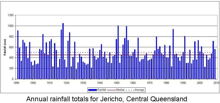
Rainfall averages are misleading, because they seem to imply what is normal and what can be expected. Figure 1
shows rainfall totals for Jericho in Central Queensland from 1890 to 2010. There are more years with below
average rainfall than above average rainfall. The median, the middle point with half the recorded values above it
and half below it, is more useful as it discounts the extremes. The average is generally higher than the median,
because it is often skewed upwards by occasional very high recordings.
Figure 1 Annual rainfall totals for Jericho, Central Queensland
The total amount of rainfall received in any year or season does not necessarily give an indication of how good that
year may or may not have been. This is because a high proportion of the rainfall may have occurred in just a few
days, or there may have been many small falls which were lost due to evaporation.
1Managing grazing lands in Queensland
High rainfall over an extended period in a summer season can produce very high pasture growth. Although a great
supply of feed is generated, the nutrient value of the feed may be poor, reducing the benefit to livestock.
Supplementing may be required to improve the quality of the feed. An outcome of the high pasture yields in these
particular seasons is the need to manage land appropriately for fires in the dry season as well as weeds and
regrowth.
High temperatures affect pasture growth and stock health. Much of the state experiences daily mean maxima of
greater than 32 degrees Celsius in January. The north-west and western parts of the state have the highest
temperatures. Heatwaves can be severe, especially in dry years. Frosts are a regular feature of the inland
environment in winter in southern areas of the state and cause rapid deterioration of above ground parts of many
pasture species.
Future scenarios related to climate change may make the task of managing grazing lands even more complex.
Increased temperature variations (both maxima and minima), more intense rainfall events but reduced rainfall
overall, and rises in evaporation rates are likely to have a negative impact on grazing animals, pasture production
and the health of our grazing landscapes. Results from experiments where plants were subjected to increased
atmospheric carbon dioxide levels showed there are likely to be some ecological changes in grazing lands, for
example giving advantage to woody vegetation over grasses.
The future impact of climate change on El Niño (i.e. a weather phenomenon that occurs in the eastern and central
equatorial Pacific Ocean, where the region's winds weaken and sea temperatures become warmer) is still uncertain.
However, the proportion of El Niño compared to La Niña (i.e. a cooling of the equatorial waters in the Pacific
Ocean causing chaotic weather changes worldwide) events has increased over recent decades, causing more
frequent and prolonged periods of drought. More information on the above topic is available on the Queensland
Office of Climate Change website at .
The following CSIRO publications also provide more information. They can be found by typing the titles into a
web search engine:
Climate change impacts on northern Australian rangeland livestock carrying capacity: a review of challenges
The climate change risk management matrix for the grazing industry of northern Australia.
Land types in Queensland
The CD_ROM Land types of Queensland provides information about more than 230 land types from 16 Grazing
land management (GLM) regions in Queensland. Land type descriptions include landform, woody vegetation,
expected pasture composition (including suitable sown pastures and introduced weeds), soil characteristics,
biodiversity features and the regional ecosystems that they occur in. Limitations of each land type are provided
together with land and grazing management recommendations. A copy of the CD-ROM can be obtained from the
Department of Employment Economic Development and Innovation (DEEDI) by phoning 13 25 23 or via the
website .
The land types represented on the CD-ROM vary from better quality clay soils, fertile loams and friable earths that
are representative of about one-third of Queensland, to the less fertile texture contrast soils, massive earths and
sands representing two-thirds of the state. These less fertile soils are naturally low in organic matter and some plant
nutrients.
2Managing grazing lands in Queensland
Land and pasture degradation
Land degradation has had an enormous impact on the productivity and biodiversity of some of the state’s grazing
lands. Forms of degradation include:
• soil erosion by both water and wind
• invasion by exotic weeds including succulents, vines and woody species
• thickening of native species
• reduction in pasture quality through selective grazing or overgrazing
• salinity.
The introduction of cattle with a greater ability to forage under adverse conditions, combined with the use of
drought supplements, has had a negative affect on land condition. That is, when a drought breaks increased
numbers of stock feed on the growing grasses.
Erosion by water begins when raindrops fall on bare soil. Raindrop splash and the dislodgement of soil particles
cause the surface to seal, and runoff begins. Lighter textured, bare soil surfaces are also susceptible to wind erosion
as winds move much faster over a soil surface without vegetative cover. If all of the topsoil is removed, the land is
referred to as being ‘scalded’, with the term ‘clay pan’ also used to describe such land.
Erosion reduces productivity by dislodging topsoils that are often very shallow and contain the majority of
available nutrients and organic matter in the soil profile. In arid, low nutrient landscapes, many of the available
nutrients can be lost when dust particles are lifted by a dust storm. Eroded soils are subject to more extreme
temperature ranges and have lower porosity and microbial activity.
A downward spiral of degradation begins when high runoff rates result in reduced entry of water into the soil
causing less plant growth. Land degradation can have a significant affect on natural biodiversity by reducing
habitat quality for most living things—whether above or below ground level, or in water.
Nutrients are made available to pastures via the process of mineralisation and the breakdown of organic matter.
Fertility decline, including a decline in soil carbon levels in pasture lands is a common occurrence especially where
land is subject to continued heavy grazing pressure and erosion.
Virtually no fertilisers have ever been used in the rangelands of Queensland because their use is not considered to
be economic. In many areas a positive response to fertilisers would be likely in good seasons when soil moisture is
not limiting plant growth. However, the high cost of purchasing and distributing fertiliser in areas with an
unpredictable climate generally rules out any opportunity for its use.
Once land condition deteriorates, its ability to grow useful pasture declines and it becomes more susceptible to
extreme weather events. In GLM workshops graziers are provided with information to help them classify land into
four different conditions that vary from condition A to condition D. Condition A has a good coverage of desirable
pastures species, few weeds, good soil condition and no problems from woodland thickening. Condition D land can
have problems such as a general lack of desirable pastures, severe erosion resulting in a hostile environment for
plant growth and thickets of woody plants over most of the area
Table 1 provides an example for the Poplar box with sandalwood understorey land type in the Maranoa Balonne
GLM Region. For the same land type, land in very good condition (GLM Condition A) produces more pasture and
has a higher safe carrying capacity than land that has been subjected to significant degradation (GLM Condition C).
3Managing grazing lands in Queensland
Table 1 How land condition affects safe carrying capacity
condition A
condition C
Data applicable to the Poplar box with sandalwood understorey land type in the Maranoa
GLM
GLM
Balonne GLM Region
Average dry matter production kg/ha/year 3000 1350
(as calculated by the GRASP* Model)
Average amount of pasture available assuming a 20% utilisation rate (kg) 600 270
Pasture consumed by a 450 kg steer in one year (kg) 3650 3650
Number of hectares required for one 450 kg steer 6.1 13.5
Safe carrying capacity for a 500 ha paddock (450 kg steers) 82 37
*GRASP is a pasture growth model for tropical and sub-tropical grasses which can be calibrated for a broad range
of pasture communities, soil types and climatic conditions.
Sustainable stocking rates and favourable seasons may, over time, allow land to improve its condition and to store
increased levels of soil carbon. However, land in condition D will, in most cases, have lost all of its topsoil and
preferred grass species. It may be incapable of being brought back to a better land condition.
Gully erosion occurs in drainage lines or other areas where runoff has concentrated. It may occur as an isolated
event or over large areas, especially where there are soils with highly erodible subsoil.
Stream bank erosion is a common problem in most Queensland river systems. River frontages are particularly
subject to erosion in areas where stock congregate.
The movement of sediment, nutrients and organic matter may adversely affect water quality in streams and the
coastal environment. Soils with highly erodible, dispersible sub-soils contribute significantly to turbid runoff.
Dispersible soils are structurally unstable and when exposed to water readily break down into their constituent
particles of sand, silt and clay. Individual clay particles are very fine and remain suspended in water rather than
settling out. This leads to a turbid or muddy appearance in dams and watercourses.
Pasture management
The Department of Environment and Resource Management’s (DERM) publication, Guidelines for Determining
Lease Land Condition, describes how pastures are evaluated as part of the lease land condition assessment for the
Delbessie Agreement. The indicators assessed include the relative proportion and density of preferred, intermediate
and non-preferred species as well as their health.
Land type information sheets list the species that occur under the categories ‘preferred’, ‘intermediate’ and ‘non-
preferred’. The best pasture species are classified as ‘preferred’ because they generally have three critical
characteristics:
perennial (long lived and generally have extensive root systems, which can extract more nutrients and water
from the soil to produce more growth than annuals)
palatable (livestock will eat them)
productive (provides sufficient growth and nutrition for good livestock production).
Some annual species also have a ‘preferred’ status in land types that are naturally dominated by annual species.
‘Preferred’ pasture species such as kangaroo grass or Queensland blue grass will gradually be replaced by ‘non-
preferred’ grasses when they are subjected to heavy grazing pressure. Non preferred grasses such as wire grass
species are generally unpalatable and unproductive and some species can be poisonous to stock.
4Managing grazing lands in Queensland
The following management options should be considered for keeping land in good condition with a high proportion
and density (and thus good ground cover) of preferred species:
manage total grazing pressure
use appropriate utilisation rates
implement appropriately timed spelling and herd management strategies
monitor pasture composition
use of hay, supplements, fodder trees and shrubs in a strategic manner
manage the tree/grass balance to avoid woodland thickening
implement forage budgeting strategies
use climate and seasonal forecasting resources
maintain native grassland free of encroachment from woody vegetation
use appropriate fire management practices
fence according to land types
manage the distance stock have to travel to water.
Managing total grazing pressure
Managing total grazing pressure is the key to maintaining pastures dominated by palatable, perennial and
productive species. Native animals such as kangaroos and feral pests such as rabbits, can greatly increase grazing
pressure and compete with livestock for feed. In many areas, kangaroo numbers have increased as more permanent
watering points have been established for livestock. Rabbits have traditionally thrived in land types which have
softer soil types, such as soft mulga. As well as adding to grazing pressure, rabbits compete with many native
animals, like the burrowing bettong and bilby.
Pastures that have been destocked for regeneration (e.g. after a fire) can be a prime target for kangaroos and feral
pests. Closing down watering points in these paddocks may help to reduce their numbers, however, some evidence
shows that moisture in plants alone may sustain kangaroos for a reasonable period. In stocked paddocks, fencing
off reticulated water with swing or trap gates may encourage kangaroos to graze elsewhere.
Kangaroo numbers can also be managed by licensed harvesting or culling. This can be especially useful at the end
of the summer growing season when stock numbers need to be managed going into winter. Some graziers are
attempting to fence their properties to exclude kangaroos.
Using appropriate pasture utilisation rates
The amount of annual pasture growth (from July to June) that is consumed by grazing animals is referred to as the
utilisation rate. The safe utilisation rate for land types can vary from around five per cent to 30 per cent depending
on land type and climate. In very arid environments or degraded land, safe utilisation rates may be less than five per
cent.
High rates of utilisation may seem more profitable in the short term but will cause degradation of pasture bases if
continued for a period of time. Heavy grazing can have the following impacts:
tussock size is reduced—fewer tillers are produced, the root system contracts, less seed is set and the plant
may die—these effects are most severe on the pasture species that stock prefer
if ground cover is poor, drought breaking rainfall may be lost as run-off which could erode the soil and delay
the recovery from drought
less preferred species and weeds (i.e. herbaceous and woody) invade.
5Managing grazing lands in Queensland
Low utilisation rates may appear to 'waste' feed but they allow the pasture to:
recover following periods of stress
remain vigorous
seed
add ground cover
help maintain soil health.
Over time, the condition of land can improve with low utilisation rates.
Implement appropriately-timed spelling and herd management strategies
Most damage from grazing occurs when grass is shooting from its reserves after a dormant period—in spring or
after a drought or fire. Grazing during flowering and seed set will reduce seed reserves. Overgrazing at this time
allows non-preferred species to gain a foothold in the pasture.
The length of time to destock depends on:
the condition and amount of pasture
rainfall during the growing season
the reason for spelling.
Complete rest for as little as three to six weeks during the early to mid growing season can have long term benefits
for pastures. It gives highly desirable but slow to establish native species, such as kangaroo grass and forest
bluegrass, a chance to rejuvenate their crowns, restore root energy reserves and set seed. It also enables recruitment
and establishment of these species, ensuring their survival.
Spelling for one to two months during the peak growing season will allow the palatable grasses to set seed; spelling
for four to eight months allows fuel to accumulate and persist for a spring fire to control woody weeds.
Partial destocking of a paddock may not be effective if the remaining stock continue to concentrate on their
preferred species.
It is most practical to spell in a wet year when there is abundant pasture. Prior warning of possible wet conditions
can be obtained by checking the Southern Oscillation Index (SOI) and outputs from the AussieGRASS model (refer
to the section titled 'Utilising climate and seasonal forecasting resources').
Types of grazing systems
There are many different types of grazing management systems. Matching stocking rates to carrying capacity is
critical to the success of any of these systems. Examples of the systems include:
Continuous stocking—under continuous stocking, pastures rarely, if ever, receive a spell from grazing. It is a low
input system commonly used in extensive grazing lands and provides acceptable results where stocking rates are
sustainable. Stock can be very selective and preferred species can come under pressure using this system, especially
under high stocking rates.
Rotational grazing—where a period of grazing is followed by a period of rest which, depending on pasture growth,
may be days, weeks or months. Rotation periods can be based on management objectives for specific paddocks and
will depend on seasonal conditions.
Time controlled or cell grazing—a form of rotational grazing where many relatively small paddocks enable a short
graze period with heavy stocking rates followed by a long recovery period. It requires significant outlay to provide
additional fencing and watering points and requires a higher level of management than other options.
Generally animals make the best weight gains when able to select their diet over a large area under continuous light
grazing. Weight gains can be lower when a lack of choice means they eat more mature and less nutritious herbage.
This can occur when good feed is in short supply during a dry time and before being moved to the next sub-
division in a cell grazing system. However, under both of these scenarios the live weight gain per hectare can be
greater when stock numbers are higher.
6Managing grazing lands in Queensland
It can be difficult to make specific comparisons between different grazing systems. For example, some of the
benefits accrued to cell grazing, may be due to the overall higher standard of management which cell graziers are
likely to apply to all aspects of running a grazing property.
Strategic use of hay, supplements, fodder trees and shrubs
Hay and supplements such as urea, molasses, and cotton seed need to be used with care. They should only be used
to maintain or improve the condition of the animals that remain after numbers have been adjusted to the amount of
feed available. Incorrect use of supplements can contribute to high grazing pressures, particularly during and
straight after drought. This results in damage to pastures and land degradation.
Phosphorus mineral supplement may have to be fed to stock, especially breeders, when the soil has very low
phosphorus content. The greatest need is when stock graze on green feed during summer.
Fodder trees and shrubs, particularly mulga, are an important natural resource which supports sheep and cattle
production over large areas of south-western Queensland. Under the Vegetation Management Act 1999, landholders
may apply for a permit to harvest fodder. This permit is valid for five years allowing landholders to plan ahead and
apply in advance for their potential fodder needs.
More information on fodder harvesting is available at the Department of Environment and Resource Management
(DERM) website (search for the term 'fodder harvesting') or by contacting a DERM
business centre.
Case study—use of mulga as a feed source
The mulga tree or shrub is a native legume found extensively in south-west Queensland. It has
been used as a reserve food source when fodder resources are scarce. However, lopping and
pushing mulga can allow property managers to keep too many animals during droughts,
resulting in excessive grazing pressure on the limited pasture. Any pasture plants that start to
grow after rain will be subject to high grazing pressure and land condition will decline.
A lack of fire and vigorous pasture growth has allowed mulga regrowth and unpalatable shrubs
to become so thick that some land now has minimal grazing value, except for browsing
purposes. As the density of trees and shrubs increases, grass production declines.
The key to managing mulga and pasture together is to maintain a healthy grassy pasture. In
droughts, the area over which mulga is harvested should be limited. At other times, mulga
should be used as a supplement to, not a replacement for, perennial pastures.
If there is sufficient fuel for a fire, a burning management system for shrub control in the
mulga country is beneficial for livestock production and conservation. Rainfall following
burning will lead to overall improvements in the pasture including:
• decreased shrub densities
• increased pasture production
• improved ground cover and reduced runoff
• reduced wind and water erosion
• reduced impact of drought.
Mulga branches harvested for fodder should ideally be placed on the ground at right angles to
the slope. They can help pasture to recover by reducing water runoff and soil erosion, trapping
mobile surface soil and seeds and by preventing livestock from grazing grasses that re-shoot
under the branches.
Any harvesting or burning of fodder trees or shrubs requires an approval under the Vegetation
Management Act 1999. Contact a DERM business centre for information on the application
process.
7Managing grazing lands in Queensland
More information on the use of mulga as a fodder source is available from the DEEDI fact
sheet Livestock nutrition – Feeding mulga to sheep in south-west Queensland.
Implementing forage budgeting strategies
Forage budgeting is used to manage the balance between forage demand and forage supply in the short term, taking
seasonal conditions into account. The Stocktake package (see 'Further information') developed by DEEDI and Meat
and Livestock Australia can assist graziers to prepare forage budgets.
When deciding on stocking rates for a paddock, feed budgeting techniques and the time span that stock are
intended to be in the paddock need to be considered. The effects of native animals such as kangaroos and pests
such as rabbits need to be considered also.
The basic process for forage budgeting is as follows:
calculate how much edible forage exists in the paddock
decide how much needs to remain after the animals are taken out in order to maintain pasture condition and
ground cover
nominate the proportion of the pasture that is to be consumed in that time period
work out how much each animal will eat per day
decide how long the animals are to stay in the paddock
calculate how many animals can be safely run for that period.
A good time to assess the amount of feed and to adjust rates is in March-April at the end of the growing season. In
more productive pastures, the aim should be to have at least 40 per cent ground cover and 1000 kilograms per
hectare of pasture at the beginning of the next summer storm period. In more arid areas, a target of 500 kilograms
per hectare may be all that is achievable.
The Pasture Photo-standards CD-ROM (available from DEEDI) is useful for developing pasture budgets and dry
season business management plans. The CD-ROM contains photo-standards and corresponding pasture yields for
many of Queensland’s common pasture communities and is searchable according to region or pasture type.
Utilising climate and seasonal forecasting resources
Because droughts are a recurring natural event in Queensland, it is essential to plan and manage for them. Seasons
of below average rainfall are not unusual and should not have disastrous consequences. If properties are managed
for drier-than-average years, better seasons become a bonus for both production and the landscape.
Monitoring seasonal forecasts based on the Southern Oscillation Index (SOI) and other measures of the El Niño-
Southern Oscillation phenomenon (commonly referred to as ENSO), such as sea-surface temperatures helps to give
an outlook for future seasonal conditions.
The SOI measures the differences in air pressure between Tahiti and Darwin. The index scale ranges from about
+30 to -30. When the SOI is strongly positive (i.e. greater than +5 and referred to as a La Niña phase) trade winds
blow strongly across the Pacific Ocean picking up moisture. In this situation, much of eastern Australia has a
chance of receiving greater than average rainfall. With a strongly negative SOI (i.e. less than -5 and referred to as
an El Niño phase) trade winds are weakened or reversed and there is a probability of below average rainfall in
eastern Australia.
ENSO fluctuates from one year to the next and the SOI is most strongly related to rainfall and climate from winter
through to summer. Another phenomenon which influences rainfall and climate over longer time scales is the Inter-
decadal Pacific Oscillation (IPO) or Pacific Decadal Oscillation (PDO). When measures of the IPO and ENSO are
considered together, improved outlooks for rainfall, with a longer lead time can be obtained. For example, search
for 'SPOTA-1' on the Long Paddock website at .
As drought conditions develop, it is important to adopt a strategy early while options are available. Stocking rates
should be managed according to the pasture available and the condition of that pasture. Stock should be sold or
8Managing grazing lands in Queensland
agisted early in the dry season while they are still in good condition and fit to travel and the pasture is not yet
overgrazed.
Valuable climate information about managing climatic risk is available on the Long Paddock website
. For example, Figure 2 depicts data obtained from the AussieGRASS model in
February 2010 showing predicted pasture growth for March to May 2010. The estimate is made by considering soil
type, pasture type, tree cover and expected rainfall, temperature, humidity and grazing pressure. AussieGRASS is a
spatial version of the GRASP pasture simulation model.
Figure 2 An example of information available from the Long Paddock website
The Long Paddock website also provides information on:
seasonal climate outlooks—based on the SOI (SOI Phase Scheme) or sea-surface temperatures (SPOTA-1
scheme which stands for Seasonal Pacific Ocean Temperature Analysis version 1)
historical climate variability
rainfall maps from 1890 to present
pasture growth, relative to pasture records from 1957 to present (will be progressively added to the website
using the simulation model AussieGRASS).
Access to the FORAGE system, which provides information relating to climate and pasture condition at user-
specified locations, is also available from the Long Paddock website. FORAGE can be used to assess climate risk
and land condition, and to help make management decisions. The system provides a Rainfall and Pasture Report
and a Ground Cover Report, as well as products based on satellite imagery of ground cover. It receives requests via
the website, which it processes, before generating and emailing the relevant information back to the user. The
9Managing grazing lands in Queensland
Rainfall and Pasture Report from FORAGE provides a 30-year time series of interpolated annual rainfall, model-
simulated annual pasture growth, pasture biomass (i.e. total standing dry matter) and pasture-litter cover. The
Ground Cover Report from FORAGE provides a time-series of pasture ground cover derived both from model
calculations and satellite imagery. The report is based on around 20 years of data.
An additional software package that provides valuable climate information is Rainman Streamflow 4.3 (see 'Further
information'). This program contains long-term historical rainfall data for some 3800 locations throughout
Australia. Using Rainman Streamflow 4.3, users can update monthly rainfall data via the Internet each month free
of charge. Landholders can also enter and analyse their own rainfall data for answers to questions like:
'What chance do I have of getting 120 millimetres of rainfall between October and December (based on
different SOI values)?'
'How often have we had 75 millimetres of rain in one day?'
'How dry were the 12 months up to April 2003 relative to the long-term average?'
The computer program HowOften? is also a useful tool for providing climate information. This program will
answer queries such as, 'How often does x mm of rain occur between two specified dates at a specified location?'
Managing the tree-grass balance
With the exception of natural grasslands, most pasture species grow in association with woody vegetation such as
trees and shrubs. Woody vegetation generally has a more extensive root system and a broader canopy than
individual herbaceous plants. Trees compete with pastures for water, nutrients and light. Managed correctly, trees
can enhance the grazing value of a pasture landscape. The grass under trees is sometimes of higher quality than
grass growing in open areas—particularly in areas with infertile soils. Trees provide:
shade and shelter for animals, reducing heat and cold stress
moderate ground temperatures in both summer and winter
mobilised nutrients from deeper in the soil profile
lower ground water tables and reduced salinity problems
reduced wind velocities and improved microclimate for herbage growth
improved biodiversity.
Persistent, heavy grazing pressure can lead to woodland thickening. A resultant lack of fire and reduced
competition from the herbaceous layer allows woody plants to proliferate. This can lead to:
reduced grazing value
reduced soil surface cover
increased risk of erosion
colonisation by pest plants
limited access for management purposes (e.g. mustering and weed control).
Under the Vegetation Management Act 1999, approval is required to thin remnant vegetation shown on a regional
ecosystem map. Clearing of regrowth shown on a regrowth vegetation map must be notified to DERM and
conducted in compliance with the Regrowth Vegetation Code. Regional ecosystem maps and regrowth vegetation
maps can be requested for individual lot on plan numbers, free of charge, from the DERM website
(search for 'regional ecosystem map' and/or 'regrowth vegetation map' in the search field
on the top right-hand side of the home page).
Maintaining native grassland free of encroachment from woody vegetation
Some grassland ecosystems in Queensland are being invaded by woody species. Encroachment is considered to
have occurred when the description of an area is no longer consistent with the description of the regional ecosystem
(RE) with which the area was mapped.
10Managing grazing lands in Queensland
Permits under the Vegetation Management Act 1999 are required before clearing woody vegetation in some
grassland ecosystems. More information can be found in the fact sheet titled 'Grassland regional ecosystems and
encroachment', which is available on the DERM web site at . The fact sheet lists grassland
ecosystems where woody vegetation may be cleared without a permit and those where a permit is required before
clearing. Natural woody patches in grassland RE’s are not considered to be encroachment and cannot be cleared.
Landholders should also check requirements under other Acts, such as the Commonwealth Environment Protection
and Biodiversity Conservation Act 1999, which may affect grassland management.
Using appropriate fire management practices
Fire has played an important role in shaping Australian landscapes and the composition of their fauna and flora.
Before European settlement, fires would have been a regular occurrence, especially following good seasons. They
would have been started by lightning strikes or by Indigenous people to flush game and create fresh pick. Such fires
may have covered large areas at a time. The lack of watering points in much of the landscape would have meant
that large areas would have been subject to low grazing pressure making it more susceptible to wildfires.
Since the introduction of livestock, the use of fire at the beginning of the growing season became more frequent in
many areas to promote fresh plant growth. However the provision of watering points means that much larger areas
are grazed regularly providing less fuel for fires. Degraded areas or areas subject to woodland thickening are often
incapable of producing sufficient fuel for a fire that may be needed for weed control. In the absence of fire, natural
open grasslands can be invaded by woody weeds, such as prickly acacia and mimosa, and native species, like
gidgee.
Wild fires today are likely to cover smaller areas when compared to before European settlement. Less fuel makes
fires easier to manage assisted by barriers such as fire breaks and roads which create opportunities for backburning.
This section covers a number of issues related to the use of fire. Due to extreme variations in climate, land types
and weather conditions, it is not possible to provide strict ‘recipes’ about fire management in the grazing lands of
Queensland.
DERM is preparing guidelines on burning strategies for all regional ecosystems in Queensland. The guidelines are
based on an ecological perspective and are designed to enhance biodiversity. Strategies may need to be varied
depending on prevailing weather conditions, the local condition of the land, presence of specific weeds and the
desire to increase the population of a specific endangered plant or animal. For more information visit the DERM
website (search for 'regional ecosystems fire management guidelines').
Fire as a friend
If managed appropriately, fire can be a beneficial tool for graziers and land managers as it:
reduces fire hazard
controls weeds such as rubbervine, prickly acacia and mimosa
controls native woody vegetation that is thickening and suppressing pasture growth
removes rank old grass so stock can reach new growth and obtain a more nutritious pick
stimulates new growth including seedling regeneration (e.g. fire favours spear grass germination)
evens up patchy grazing by encouraging stock onto burnt areas.
Fire as a foe
Fires which result from a lightning strike or spread from neighbouring land can devastate a property’s landscape
and infrastructure. They can create a shortage of feed and create an erosion risk.
The excessive use of fire on a property can have a significant impact on the population of some plants and animals
and on surface soil structure.
11Managing grazing lands in Queensland
Managing fire
For many pasture landscapes in Queensland, a fire every three or four years can provide benefits. For this to occur,
pasture needs to be managed so that there is sufficient fuel to support the fire. If it is rare that there is sufficient
grass to support the fire, a paddock is probably being overgrazed—topsoil may have been lost and/or woody
vegetation may be impacting on pasture growth.
Higher rainfall coastal areas are more likely to be able to produce sufficient grass for a fire than arid, inland areas
where the use of fire is very limited. In some arid landscapes the use of fire is not recommended because local
vegetation is fire sensitive (e.g. saltbushes).
There is a tendency for fire to be over-used in northern regions of the state and under-used in southern areas. One
reason for the under utilisation of fire is that the land is not capable of producing sufficient combustible material to
provide enough fuel for a suitable fire. This may be due to low rainfall, heavy grazing or a dominance of woody
vegetation.
Occasional fires do not damage native pasture species, however, new growth and seedlings that emerge after the
fire can be damaged when subjected to heavy grazing pressure. From a grazing perspective, it is better to burn all,
or a large part of the paddock. This would avoid the situation where stock might concentrate on and weaken the
new growth in a small area that had been burnt. From a biodiversity viewpoint, ‘mosaic’ burning (burning parts of
a paddock at different times) has benefits because it allows animals and plants to survive in refuge areas.
When to burn
As a general guide, in North Queensland the best time to burn is after the first rains following the dry season. After
burning, the moisture in the soil, as well as subsequent rainfall, aids the recovery of the pasture. A very hot fire that
occurs when there is considerable fuel and extreme fire conditions will lead to a slow recovery if there is no rainfall
for six months. In Southern Queensland, burning in winter or early spring is preferable to kill mature shrubs and
their seedlings without damaging the regenerating grasses.
Burning in the dry season is risky because the wet season rains may fail resulting in a lack of feed for an extended
period. If the first rain afterwards is heavy, the lack of cover may result in high rates of runoff and soil erosion.
In order to control woody weeds, a hot fire is generally required. Fire does not kill all woody growth, but will check
or control it. The smaller the woody weed is, the more susceptible it is to fire.
A permit from the local Fire Warden of the Queensland Rural Fire Service is essential before commencing burning.
Further information to consider prior to burning is available from The Queensland Rural Fire Service website
. An assessment of the current fire hazard for different parts of the state is shown on the
Long Paddock web site (check the Pasture Curing Index and the Potential Grassfire risk indicator). These two
products are based on the AussieGRASS model.
Care must be taken when establishing and maintaining firebreaks to avoid the spreading of weeds and the
concentration of runoff leading to erosion. Further information is contained in the DERM fact sheet L241 Erosion
control on fences and firebreaks.
Fencing to land types
Fencing according to land type can help overcome the problem of stock grazing one land type in preference to
another in the same paddock. Persistent grazing of one land type can lead to a reduction in palatable productive
pasture species and deterioration in soil surface conditions in part of the paddock while the rest of the paddock is
under-utilised.
Fencing of riparian corridors or providing off stream water points can be particularly beneficial for the conservation
of these valuable assets and is discussed later under 'Protecting riparian vegetation'.
12Managing grazing lands in Queensland
Managing distance to water
There is a strong relationship between grazing pressure and distance to water (Figure 3). In large paddocks with
sparsely placed watering points, grazing pressure around watering points is high, whilst other parts of the paddock
may not be grazed at all.
While cattle can walk up to 10 kilometres for water, uneven use of forage can be evident even when watering
points are spaced four to six kilometres apart.
Figure 2 Relative grazing pressure in relation to distance from water. Source Grazing land management- Maranoa Balonne Version
Workshop notes MLA 2005
Managing watering points and dietary supplements, such as mineral licks, can be an effective way for managing
stocking and pasture utilisation rates. They should be located to:
encourage more even pasture utilisation across a paddock
minimise erosion risks
minimise pollution of watercourses (from dung and urine).
It is important to consider that:
in mid summer, sheep are unlikely to graze beyond three kilometres from water, and cattle five kilometres,
and they may return twice daily
locating a new watering point in a less preferred area of a paddock will help to spread grazing pressure, but
may also have a negative impact on biodiversity by giving stock access to a previously ungrazed area
capping and piping of bores to troughs provides much more control over the location of watering points
watering points should be placed in areas where the soils are least susceptible to erosion
watering points should be placed on the opposite side of the paddock from the prevailing winds—stock are
more likely to walk towards water into a prevailing wind but then graze away from the watering point with
their backs to the prevailing wind.
Monitoring pastures
Gradual changes in rangeland condition and deterioration of native pastures often go undetected unless there is a
monitoring system in place. If changes are detected early, grazing management can be modified to stop the decline
and improve pasture and land condition.
13Managing grazing lands in Queensland
Monitoring can be as minimal as taking a photo and inspecting selected parts of the paddock to check pasture
composition, condition and yield each year. Memories can be short and unreliable; a documented record allows
comparison with previous seasons and provides a record to gauge changes in the pasture.
For more information on monitoring pastures, the following publications are recommended:
Land management self assessment and monitoring kit - Rural Leasehold Land at
The Stocktake Package—refer to the section entitled 'Further information'
Not just watching the grass grow: graziers who monitor their land—available by contacting DEEDI on
telephone number 13 25 23.
Conserving soil
The DERM publication Guidelines for determining lease land condition describes how soil condition is assessed as
part of the lease land condition assessment for the Delbessie Agreement. Indicators assessed include:
soil surface condition
total ground cover
salinity.
Soil surface condition refers to evidence of water or wind erosion including the presence of rills and gullies,
exposed subsoils or soil deposits by water or wind.
Reclaiming degraded land, especially in arid and semi-arid environments, can be challenging, costly and take a
long time. It is preferable to ensure that degradation is avoided rather than attempting to repair problems later.
The top few centimetres of soil contain most of the available nutrients and organic matter in the soil profile. When
this is lost, the soil becomes even less receptive to rainfall, resulting in a near constant drought for the remaining
pasture. Seedlings have difficulty establishing on the scalded, often sand-blasted surfaces.
Maintenance of soil cover is the key to controlling erosion in grazing lands. When there is no groundcover, soil is
removed by both the action of raindrops, overland flow and wind. Valuable rainfall which should be soaking into
the soil is lost as runoff—also carrying away topsoil. Soil may be lost in sheet form, including the formation of
scalds (refer to the case study on scald reclamation). When runoff concentrates, either naturally or when influenced
by roads, fences, stock pads or firebreaks, both rill and gully erosion may occur.
Total groundcover includes pasture plants and their litter, tree leaf litter, twigs and woody debris, organic crusts,
rocks and gravel. All of these components contribute to protecting the soil surface from erosion.
Biological soil crusts occur extensively in Queensland rangelands. They are formed by living organisms that bind
together particles of soil into a crust. They can be made up of cyanobacteria (blue-green algae), mosses and lichens.
Biological soil crusts also play an important role in fixing nitrogen in the soil, improving soil’s resistance to wind
and water erosion, and contributing to plant growth. However, they are vulnerable to damage from livestock and
once damaged, can take many years to recover.
The higher the level of ground cover, the greater the benefits provided. However, a minimum level of 30 to 40 per
cent is required in order to ensure a reasonable level of protection from erosion and to perform the other ecological
functions of ground cover. To achieve this cover level at the beginning of the summer storm season, a surface cover
level of around 70 per cent is desirable at the end of the summer growing season.
Depending on tussock size and spacing, some pasture types are more conducive to providing good cover levels than
others.
14Managing grazing lands in Queensland
Key issues to address in maintaining cover are:
stocking rates
total grazing pressure (domestic stock, feral and native animals)
thickening of woody vegetation (competes with groundlayer plants and may contribute to bare soils under the
vegetation).
Case study—scald reclamation
Scalds or clay pans are bare areas produced by the removal of topsoil by wind and/or water
erosion. Raindrops hitting the bare soil surface can ‘sort’ the soil so that the fine sand, silt and
clay particles are re-arranged and packed together. This fills the pore spaces at the surface,
causing a surface seal which sets hard like concrete.
Under normal conditions, evaporation effectively pulls water (and any salt that may be
present) in the soil to the surface while rainfall effectively pushes the salt back down. When a
surface seal forms, very little rainfall moves into the soil—but the salts keep rising and over
time, the levels of salt can increase in the surface layers of the soil, further inhibiting plant
growth.
Occurrence
While some scalds were reported by early explorers, high grazing pressure has been
responsible for large areas of scalding. Scalds are usually found on soils with a lighter textured
surface adjacent to watercourses, in depressions or at the base of slopes (footslopes).
Because scalded land has lost its topsoil, it is very difficult to return it to its former
productivity. However, there are techniques that help in achieving some form of recovery as
well as enhancing biodiversity and sequestering carbon.
Successful reclamation depends on one key factor—improving the soil surface so that water
infiltration is improved and plants can establish. Some options to achieve this are described
below.
Fencing off affected areas
This option encourages regeneration and revegetation by removing grazing pressure caused by
domestic, feral and/or native animals.
Recovery rate is dependent on seasons. In periods of exceptional rainfall, some scalded areas
can be covered by pioneering plant species like pigweed. However, under most seasonal
conditions this technique will need to be coupled with other management options.
Promoting cover
Cover helps limit evaporation at the soil surface and also reduces the physical action of
raindrop impact—reducing erosion and improving infiltration. Cover intercepts runoff carrying
seeds and manure and provides a favourable medium in which plants can establish.
There are few options for artificially improving cover in extensive grazing lands. It may be
feasible to apply some form of low quality hay to small areas. Applying the hay in strips on the
contour would provide benefits to a larger area. Care would need to be taken to ensure that
there were no weed seeds in the hay. Graziers in the Burdekin district have used round bales of
cane trash laid out in strips on the contour to help rehabilitate small areas of degraded land.
15Managing grazing lands in Queensland
Mechanical disturbance
Mechanical disturbance can be used to break the surface seal. Infiltration should increase,
making the surface condition more favourable for the establishment of vegetation. However,
the disturbed area may soon seal up again if no cover is established soon after treatment.
It is best to do mechanical disturbance when the soil moisture levels are just right, too dry and
it’s hard going, too wet and soil compaction can be an issue.
Water ponding
Low earth banks in horse-shoe shapes on the contour can trap the runoff from even small falls
of rain on hard surfaces. The runoff is ponded at depths of 10 to 15 centimetres and eventually
soaks into the soil. This leaches salts out of the soil profile and improves conditions for plant
growth.
On some soil types, subsequent wetting and drying causes cracking to occur which greatly
increases infiltration of water. This provides a better environment for plant growth. Once
plants are established, they trap wind-blown dust, seed and organic matter which all contribute
to the rehabilitation of the site.
An option for providing indentations to retain water on smaller areas of scalding is to allow
stock onto the surface for a limited period when conditions are wet.
Post treatment / responses
The first plants to grow back are pioneering species like pigweed and galvanised burr. In time,
improvements in organic matter from the pioneer species and reduction in salt levels near the
surface allow more permanent, useful grasses to establish.
Reclaimed clay pan areas can be used for strategic grazing. They should be grazed only when
groundcover is established and the site is dry to prevent pugging and compaction by livestock.
Gullies
Preventing gullies from occurring, is far better than attempting to control them after they have developed. In many
cases there are limited practical options for the control of gullies. Attempting to divert headwaters and to stabilise
eroding gully heads can be expensive and technically difficult, especially when the erosion is occurring on many
fronts on highly erodible soil types.
Fencing off gullied areas to restrict stock access and to encourage plants to become established may provide some
benefits. An alternative to fencing off a gully may be to add dead tree branches below an unstable gully head to
restrict stock access and to encourage sedimentation and subsequent grass growth.
Planting vegetation into sediment in the floor of the gully can hasten the healing process. Cereal plants such as oats,
wheat, barley, millet or forage sorghum can be used as they provide rapid temporary cover if there is moisture in
the soil.
For more information about gullies refer to the DERM fact sheet L81 Gully erosion available from the DERM
website .
Infrastructure
Runoff concentrations caused by roads, tracks, fence lines, firebreaks, drains or dam bywashes can lead to rill and
gully erosion. Erosion can damage these structures leading to inconvenience and increased maintenance or
replacement costs.
Careful placement of infrastructure can minimise the erosion risk. Tracks can intercept overland flows and become
eroding waterways. Whenever possible, it is best to have tracks on the contour or directly up and down slope (e.g.
16You can also read