Land Transformation in Israel
←
→
Page content transcription
If your browser does not render page correctly, please read the page content below
- ~~-~-U-.m   --~-~   ~-   ~---

Land Transformation in Agriculture
Edited by M. G. Wolman and F. G. A. Fournier
@ 1987 SCOPE. Published by John Wiley & Sons Ltd

CHAPTER 8
Land Transformation in Israel
D. H. K. AMIRAN

                              8.1 INTRODUCTION
The countries around the Mediterranean have experienced far-reaching
changes in land quality and land use. The centres of very early, highly
developed civilizations of the western world were here. Together with their
great achievements they brought about intensive use of the land-sometimes
exceSSIveuse.
   The political changes that affected the area during a millennia of its history
involved similar changes, for better or for worse, in husbanding of the land.
Extensive areas of olive groves-famous since antiquity-fruit orchards and
vineyards, many of them grown on carefully terraced slopes, indicate but
some of the prominent achievements of mediterranean agriculture. By con-
trast, periods of decline, being sometimes periods of depopulation, brought
about very adverse effects, in particular abandonment of cultivated land and
disrepair of the terraces. In consequence there was erosion of the soil, and
downwash into the valleys of the lowland plains; there was excessive sedimen-
tation in these valleys, choking the river and wadi beds, and sometimes
followed by formation of swamps owing to lack of drainage; and not infre-
quently malaria affected these swampy areas. This whole syndrome of land
deterioration is illustrated in many mediterranean countries.
    A classic case is Israel of the nineteenth century. Israel showed some
 significant achievements in agriculture and land development in antiquity, and
the deterioration is easy to follow in detail. Two factors bring about particu-
 larly significant effects of processes of land transformation. One factor is the
 country's dense population and its high rate of urbanization. The population
 density, exclusive of the Beersheva district, the largest area of which com-
 prises the Negev Desert, was 517 per square kilometre by the end of 1980,
 and 86.7% were classified as urban (90.4% of the Jewish population).
 Demands for transformation of non-urban land to urban land uses are
therefore particularly pressing.
                                           291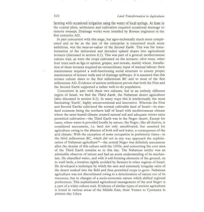
292                                           Land Transformation in Agriculture

   The second factor is the great geographical diversity of Israel. Its elements
are plains and mountains, the latter a veritable mosaic of geomorphic units,
upon which are superimposed two different climatic areas-the            mediter-
ranean climate in the north and the arid climate of the Negev Desert in the
south. The Judean Desert on the east flank of the mountains and the Rift
Valley of the Jordan owe their aridity to their topographical location in the
rain-shadow of the mountains. This diversity intensifiies the effects of land
transformation, especially if the changes occur near the border of aridity,
being the transition from mediterranean to desert climate, an area particularly
sensitive to change.   .

   This diversity of landscape, the sensitivity to changes near the. border of
aridity, and especially the long and varied history of the land of Israel, acted
upon by a variety of civilizations, and its extensive documentation, make
Israel a particularly apt topic for a study in land transformation.

          8.2 LAND TRANSFORMATION IN ANCIENT TIMES
Although evidence for land transformations in ancient times is often of a
general nature only, it is sufficient to illustrate some major trends. There is
evidence to show that the natural vegetation of the uplands of Israel, from
Galilee in the north to beyond Hebron in the Judean hills in the south, were
forests in the natural state (Gradmann, 1934, especially map 1; Zohary,
1955; 1970). They were covered by a mediterranean mixed forest. One of the
major land transformations of Israel in antiquity was the removal of this
upland forest, presumably to obtain building materials and fuel, possibly in
part by setting fire to it for purposes of hunting, or even to clear the ground
for settlement. One less 'legitimate' reason for deforestation was the need for
materials for military purposes, especially siege machinery. Historical sources
have it that the Roman command, when besieging Jerusalem in 70 AD, had
to send troops to provide logs and wood for their siege works as far as 90
stadia (18 km) from the city, as all the area nearer to Jerusalem had already
been deforested long ago.!
   It is assumed (Reifenberg, 1955) that this deforestation of the uplands
resulted in a standard series of consequences: erosion of much of the topsoil,
which in most areas was of the terra rossa type, elsewhere rendzina; excessive
sedimentation in the adjacent coastal plain, resulting in waterlogging in the
valleys; local creation of swamps, which eventually became foci of malaria;
which, becoming endemic, weakened the population and its capacity for
work, and sometimes led to desertifiqation of villages, and even to abandon-
ment of cultivation of land. There were at certain times secondary factors
fostering abandonment. The coastal plain of Israel was an inter-regional
highway of traffic between Syria in the north and Egypt in the south-west. It
was used by, amongst others, many armies and marauding bands which
plundered and extracted tribute or forced labour. Nomadic tribes from the
Land Transformation in Israel                                                 293

deserts around Israel contributed their share to this development. They sent
occasional or regular raiding parties (ghazzus) to obtain livestock and protec-
tion money-a kind of forerunner of modern mafias. 2
    As a result of all this the Romans had to apply drainage works to swamp
areas of the intrinsically fertile coastal plain, at least on the southern Carmel
coast (Nir, 1959) and at the Poleg valley south of Netanya. These drainage
works fell subsequently into disrepair and considerable areas turned into
 swamps infested by malaria. This situation persisted into the nineteenth
 century.
    However, long before this-apparently         as early as the Second Temple
period (the second half of the first millennium BC)-a              vast project of
improvement in land transformation was undertaken. This was a project
rather improbable from the point of view of the twentieth century. Instead of
reclaiming the plains land, which would have required drainage technology
and conditions of security that apparently were not available to the popu-
lation of those times, the rocky upland hillsides were transformed into agricul-
turalland. Agriculture, therefore, centred on the uplands-much of it karstic,
where soil was very shallow, if soil indeed had remained at all-instead of in
 the lowland plains where there were relatively deep soils. This land transfor-
 mation involved a tremendous investment of manual labour to create agricul-
 tural terraces, which in certain areas covered more than 50% of the total land
 surface (Ron, 1966). The construction of terraces did benefit from a rougWy
 horizontal stratification of the prevalent limestone rock. They were relatively
 narrow and accumulated a cover of terra rossa soil, on which traditionally
 olives and some fruit trees were grown, with cereals (mainly wheat) below
 them. The size and topography of the terraces excluded any mechanized
 agriculture, and do so even today in the limited areas where ancient terraces
 are still cultivated. A mule or donkey is the only m«ans used for ploughing
 beyond manuallabour.3
    Obviously, to terrace the uplands of Israel, especially the Judean Moun-
 tains, would be impossible and unreasonable under present socio-economic
 conditions: the standard of living, and therefore the cost of labour, would
 prevent both their installation and their cultivation. The philosophy behind
 these large areas of agricultural terraces, in Israel, in countries around the
 Mediterranean at large, and in many countries of the Far East (Sorre and
 Sion, 1934, pp. 41-42 and 46-48; Spencer and Hale, 1961) is based on
 minimal cost and a nearly unlimited availability of manual labour-about        the
 opposite of conditions obtaining in the late twentieth century, at least in
 developed countries. That in many countries terraces were the prevailing
 form of land use illustrates not only the basic socio-economic difference
 between the past and the present, but no less the well-known fact that before
 the industrial revolution there were but few alternatives to employment in
 agriculture.
    The active period of this upland transformation into terraces and their full
294                                            Land Transformation in Agriculture

cultivation seems to have continued up t{) about the Arab conquest (seventh
century AD). Throughout these times and until the nineteenth century the
uplands were the important region in Israel's agriculture, and therefore its
rural settlement; the lowlands and their plains with their rich natural
resources for agriculture ranked a poor second, or were barely cultivated. In
the second millennium AD most of the terraces were gradually abandoned
and deteriorated by disrepair. Today, only a few of these terraces are still
cultivated, mainly by Arab villages marginal to the mainstream of moderniz-
ation.
    Coincident in time, but not in space, with the creative stage of land
transformation in the uplands there occurred an extraordinary development
in desert agriculture in the central Negev in the south. It was initiated
apparently by the Nabateans in the first century BC and might have persisted
up to the Arab conquest in the seventh century. Considering both the area to
which it was applied and the agricultural technology employed, it was
 exceptional. Both 'Nabatean agriculture' and mediterranean terrace culti-
 vation had in their days a wide regional distribution; but unlike upland ter-
 racing, Nabatean-type agriculture had a special intellectual quality, based on
 a detailed understanding of the mechanism of desert nature (Evenari et al.,
 1971; Kedar, 1967; Amiran and Kedar, 1959; Yair, 1986).
    The Nabatean introduction of agriculture into this fully arid environment
was apparently subsidiary to their main activity, which was trading along
 caravan "routes. On some of the slopes fruit trees were grown, apparently, and
 possibly vineyards. But more important, in order to utilize the rare and highly
 irregular rainfall, they installed their fields in the wadi beds, with proper
 channelling of the rainfall from the slopes to each individual field. The slopes
 were specially treated to channel the runoff, and apparently to facilitate
 washdown of soft soil elements as well, which would accumulate in the wadi
 bed as substratum for cultivation.
    In view of the rarity and sparseness of rainfall, there was an extraordinarily
 large ratio between the drainage area on the slope and the individual field on
 the valley bottom to which it provided runoff water-between       17: 1 and 30: 1,
 with an average of about 20: 1. Owing to the strong floods which sweep the
 major valleys, Nabatean agriculture was restricted mainly to secondary wadis.
 The Nabateans, furthermore, devised a special type of cistern, adopted to the
 conditions of the prevailing types of rock, which passed the incoming runoff
 water through a strainer compartment, reduced evaporation, and was fitted
 with stairs to draw the water at successively lower levels without stirring up
 the bottom deposit.
    By all these means the Nabateans managed to live in a desert which today
 has an average annual rainfall of 80-90 mm.4 With the cessation of their
 caravan trade, their agriculture and their towns5 were abandoned and never
  revived (except today at an experimental farm at Avdat).
Land Transformation in Israel                                                 295

   8.3 RECLAMATION AND REASSESSMENT OF THE LOWLANDS
The type of extensive agriculture characterized by the slope terraces of the
uplands persisted with little improvement until the late nineteenth century. It
was only then that the next decisive step in land transformation and improve-
ment of land use was taken.
   Not bound by tradition nor by resignation to the run-down state of the
natural resource base of agriculture, the leaders .of the Zionist settlers who
returned to their ancestral homeiand made an unbiased and modem re-
appraisal of the conditions of the land. They appreciated the agricultural
potential of the soils of the coastal plain, provided they were properly
drained, which in turn would permit the eradication of malaria.6 They
understood the need for irrigation under the climatic conditions of the
inhabited northern part of Israel. 7 Its mediterranean-type climate had too
unreliable a rainfall on which to base a stable agricultural society. Further-
more, the potential advantages of the warm summer in a climate that has
exclusive winter rains could be utilized only under irrigation.
   Consequently, projects of drainage and reclamation of the plains were
initiated-a lengthy, difficult and costly process, as was gradual development
of groundwater resources for irrigation. The latter development, which began
in the 1880s, culminated in the 1950s and 1960s with the inauguration and
eventually full operation of the National Water Carrier.
   All this resulted in one of the most far-reaching revolutions in land
transformation in Israel. The lowlands-fertile         and productive regions in
antiquity-which had more and more deteriorated over time, and which by
the nineteenth century were a rundown and partly abandoned area, became
again in the twentieth century the prime agricultural region in which the
economic core areas of Israel developed. Drainage and land works reclaimed
the coastal plain, including the Haifa Bay between Haifa and Acco (Acre),
which had been swampy and highly malarious owing to the obstructed
drainage of the Na'aman River. Also reclaimed were the inland basins-the
large Yizre'el Basin (Plain of Esdraelon) and the adjacent basins of Harod
and Beth Shan to the east, sections of the Middle Jordan Valley north of here
towards Lake Kinneret (Lake Tiberias or the Sea of Galilee), and finally the
large and potentially very fertile Hule Basin in the northern part of the Jordan
Rift Valley.
   The inland basins had a variety of soils with a considerable percentage of
heavy alluvial soils, in part the remnants of the swamps. Cultivation here,
therefore, was mixed, including field crops such as cereals, fodder crops and
 vegetables, and later (since the 1960s) cotton. In contrast the coastal plain has
 a narrow stretch of heavy alluvial soils in the east at the foot of the mountains,
 but most of it consisted of light sandy soils, partly the weathering product of
 former stretches of coastal dunes.
296                                                Land Transformation in Agriculture

                     Table 8.1 Citrus production and exports

                        Planted areas (ha)
                        1922                      29000
                        1930                     106500
                        1948/49                  125 000
                        1961/62                  360000
                        1979/80                  396000
                        Production (t)
                        1948/49                  272 700
                        1961/62                  532 500
                        1979/80                1 542 700
                        Exports ($ million)
                        1949                 18.0      (63%)
                        1960                 48.2      (22.25%)
                        1970                 94.1      (12.1 %)
                        1980                233.6      (4.2%)

                     Sources: Statistical Abstract of Palestine 1937-
                     38, and Statistical Abstract of Israel for
                     relevant years.

  These light sandy soils, which are rather permeable and poor in mineral
content, had been considered a poor agricultural resource in the past. They
were but barely used for agriculture, and much of them carried a secondary
forest of spontaneous growth in which the oak (mainly Quercus ithaburensis)
prevailed. The last sizeable remnants of this forest were cut down to fire
Turkish railway engines in the First World War. The availability of irrigation
put a premium on these light soils. They permitted a vast extension of citrus
plantations, which by the turn of the century gave Israel's major export crop
and which retain their primacy among agricultural exports to the present
(Table 8.1). Irrigation was at first from local groundwater wells, and is today
from the National Water Carrier. The modem development of water
resources permitted the southward extension of citrus acreage and of other
crops. Today, the Gaza area 52 km south of Tel Aviv is one secondary centre
of citrus growing (see Figure 8.1).
   Citrus is but one element in Israel's agriculture. As agricultural economics,

Figure 8.1 . The development of areas of citrus orchards and built -up areas in Israel
between 1922 and 1967. Information was obtained from the Atlas of Israel and survey
maps, and the map was kindly drawn by Mr N. Z. Baer of the Department of
Geography of the Hebrew University of Jerusalem
(1) Area of citrus orchards in 1922           (4) Urban built-up area in 1922
(2) Area of citrus orchards in 1937           (5) Urban built-up area in 1937
(3) Area of citrus orchards in 1967           (6) Urban built-up area in 1967
.'
lEruih
C§]JJ

                      0

            fA
           i>
         c?               '?km
298                                            Land Transformation in Agriculture

genetics and agrotechnical research progressed, the variety of crops grown in
Israel expanded considerably, both for the local market and for export.
   The termination of the British mandate and independence for the State of
Israel in 1948 put high stresses on the country's agriculture. The great wave of
immigration in the early years of independence made it more than hard for
the Israeli farmer to satisfy the demands of the local market. But by the
mid-1950s the situation eased and agricultural planners turned their attention
again on 'industrial' crops and on farm exports. Therefore, in addition to
cereals for the local market, and a variety of vegetables and fruit, 'industrial'
crops such as cotton, peanuts and sometimes sugar beets were now grown, as
well as cattle (mainly dairy) and much poultry and pond fish.8
   In the early years, before the inauguration of the National Water Carrier,
farm practice had progressed from dry farming to partial irrigation with what
was known as 'mixed farming', including livestock, cereals and fodder crops,
vegetables and possibly fruit as well, all grown in the same farm unit. This was
a kind of insurance against the vagaries of climate, especially the seasonal
 amount and distribution of rainfall.9 With the availability of an expanded and
 reliable water supply from the National Water Carrier, agriculture started to
 specialize and focus on a rather limited range of crops, benefitting both from
the advantage of specialization and the economy of scale.1O
    Much later, when after 1967 the Lower Jordan Valley south of the Beth
Shan Basin again became accessible to the Israeli farmer, here too a radical
land transformation occurred. This is an area with a distinctly arid climate, the
result of its location in the rain-shadow of the uplands of Samaria and Judea a
thousand metres and more below them. 11 For generations prior to 1967, this
hot and sticky area was unavailable as agricultural land to the fellaheen and
their simple agricultural technology (there were some very minor exceptions
based on mediocre springs at the outlet of Wadi Far'a). Here the same
regional advantages for out-of-season agriculture prevailed as the Israeli
farmer had learned to use in the Negev; water was provided by systematic
drilling on the fault borders of the Rift Valley, and an intensive agriculture
has developed in the Jordan Valley since the late 1960s. It uses as a soil base
the alluvial cover spread by the large and small valleys coming down from the
uplands over the saline marls and underlying rocks of the rift bottom. In this
respect the Jordan Valley has a definite advantage over the Negev, where
sterile hamadas are the standard cover of the area and arable soil occurs in
strictly limited locations. Incidentally, under essentially similar conditions, the
Ghor project has been developed across the river in Jordan.
   It is important to note that present-day Israeli farmers were not the first to
engage in agriculture in this potentially fertile region. In antiquity, farmers
used a sophisticated technology widely used throughout the Middle East; they
installed kanats-underground        tunnels for conducting water-in order to
cultivate areas in the Phasael region at the outlet of the Far'a Valley. These
Land Transformation in Israel                                                  299

fell into disrepair, and cultivation ceased here apparently more than a
millennium ago (Cressey, 1958; Evenari et al., 1971, pp. 172-178; Porat,
1970; llan, 1973; Troll, 1963).
    The Lower Jordan Valley is thus another striking example illustrating that a
certain region with a distinct agricultural potential was utilized in antiquity by
farmers to whom kanat technology was available. It reverted to anecumene
for well over a thousand years when backward farmers employing simple,
'traditional' methods of farming had neither the means nor the initiative to
cultivate it. In recent years this same area-apparently          even larger in size
than in antiquity-forms      a flourishing agricultural district thanks to research
that has developed a technically advanced agriculture.
    There is one specialized aspect of land transformation that deserves special
mention-fish ponds. Apart from the insignificant amounts of sea fish landed
by Arab fishermen at Jaffa and Acco, there was no supply of fresh fish in Israel.
In the mid-1930s a few fish ponds were installed in the Kurdaneh swamps in
the Haifa Bay using the saline water of the nearby springs. At the time carp of
near-marketable size were imported from ponds in Yugoslavia and sold in
Israel when they reached proper size. This was a profitable business, as carp
for 'gefillte fish' commands a good market for the Jewish shabbat and
 holy-day table. The Kurdaneh enterprise, however, was an ephemeral pro-
 ject.
    In the mid-1950s fish-ponding was revived, this time at first in the Beth
 Shan Basin. When the water resources of the basin were being developed,
 some large saline springs had to be reckoned with. Their water, as was that of
 the Kurdaneh springs mentioned above, was too saline to be used in agricul-
 ture. Part of it was mixed with good-quality water to an admissible level of
 salinity and was used for irrigation. The more saline water was used for fish
 ponds. In this way two sub-marginal resources were utilized. A few years later
 fish ponds were integrated into the agricultural layout of the Huleh Basin on
 completion of its drainage: surplus water was available here and used in the
 ponds.
    Pond-fisheries soon appeared to be one of the most remunerative branches
  of Israeli agriculture, owing to the low input of labour. Fish ponds, therefore,
  appeared in most of the plain areas of northern Israel, as far south as the
  Hadera region of the coastal plain.12 In the coastal plain, ponds were even
  installed on dune sand quite near to the beach. The sand was made impervi-
  ous after a short time by lining the pond with chicken manure. Poultry
 manure, in fact, was a major element of feeding. Poultry farming and fish
 breeding, therefore, were often connected at the village (or at least at the
 regional) level. Fish breeding remained a preferred branch of agriculture for
 many years and receded only recently (Table 8.2). Unlike the early venture at
 Kurdaneh and its successor in the Beth Shan Basin, most fish ponds now use
  regular water from the National Water Carrier, augmented by rainwater. As
3.00                                                 Land Transformation in Agriculture

                Table 8.2     Fish ponds

                                   Area            Volume of production
                                   (ha)                    (t)

                1948/49            1500                      2509
                1969/70            5400                     12000
                1978/79            4100                     13 900

                Source: Statistical Abstract of Israel for relevant years.

this involves high water losses by evaporation, the Water Commissioner is
not in favour of expanding pond acreage, and actually attempts to restrict it.

The striking progress of lowland agriculture in various regions of Israel as
treated above had negative repercussions on land use and the agricultural
economy of the uplands. It has been mentioned that most of the upland
terraces were gradually abandoned and deteriorated by disrepair throughout
the second millennium AD. It is a telling expression of the state of deterio-
ration of Israel prior to Zionist reclamation that, irrespective of this deterio-
ration of upland areas, the uplands were still the most important agricultural
region and the (economically speaking) 'leading' part of the country, if this
term is applicable in the present context; and the region was definitely the most
densely populated area until very late in the nineteenth century. All this is a
striking measure of the decline and deterioration of the area over many
centuries, which came to an end less than a hundred years ago.
    The striking advances of lowland agriculture, and the standard of living
they allow, today make upland farming on terraces a very poor second best.
This applies not only to the resulting standard of living for the farmer, but also
 to the cost of the product, and therefore its ability to compete in the market.
 When labour was still relatively inexpensive, terrace agriculture was main-
tained in the Arab sector, and even slightly expanded beyond the
nineteenth-century acreage. Similarly, a number of Jewish villages cultivated
 upland areas, mainly on terraced land, some of it improved and modernized.
Today, when labour is nearly the most expensive element in agriculture, there
 is further regression of upland agriculture, the progressive element of which
 concentrates on specialized crops for which there is a regional advantage in
 the uplands, and to a large extent in the development of recreation as a
 regional resource, for which the uplands have a definite climatic advantage.
 These include rest houses, and even hotels, restaurants, picnic areas, rec-
 reational forests, swimming pools, sports grounds, and the supporting agricul-
 tural production. All this is in addition to generally small-but often highly
 specialized-industrial   plants, which in many upland villages are today the
 most important branch in the village economy (particularly in kibbutsim).
Land Transformation in Israel 301
To sum up, by the second quarter of the twentieth century the century-old
pattern of land use in Israel had been radically transformed. The plains were
again the country's principal agricultural area, in a modern agricultural
technology and economy. The uplands, which for many centuries had been
the important agricultural region and the important region of settlement,
reverted to second rank in regional status, with the resort industry and an
increasing residential land use by a commuter population assuming gradually
more importance as the major regional resource base (see section 8.6).
8.4 PRIMARY RESOURCE BASES FOR AGRICULTURE (OTHER THAN
SOIL)
The mise-en-valeur of land for agriculture in Israel until the 1950s had
proceeded on a conventional pattern, expanding by a series of agro-technical
improvements. The completion of the National Water Carrier in the 1960s,
which led to both a much greater rentability and reliability of farming,13 and
therefore created considerable capital resources, permitted the natural
resource base to be used in a new and unconventional way. This involved a
number of phases, each one with special regional emphasis.
A sober appraisal of the possibilities created by the difference between the
winter climates of the northern Negev (and better still the Arava section of
the Rift Valley further to the south) and that of the European market, and to
a lesser degree that of the populated north of Israel, brought about the
mise-en-valeur of these areas which, until about 1950, had been considered
entirely unsuited to agricultural use. Parts of the desert south of Israel with a
fully arid climate were transformed into intensively cultivated agricultural
land. The key to this development was the inter-regional differences in winter
climates (Table 8.3). Even in mid-winter, the average daily maximum tem-
peratures are high enough to permit the harvesting of vegetables and fruits, as
well as flowers which were for a time part of the region's exports. The desert
climate, which by its very nature has minimal and very infrequent rainfall, 14
therefore has minimal cloudiness as well. This even gives it an inter-regional
advantage over the north of Israel, with its mediterranean climate and winter
rams.
For this resource base for 'out-of-season' agriculture, suitable soils and
water had to be identified, capital for basic investment provided and the
marketing structure organized. By definition, neither water nor soil for
agriculture are usually available in a desert; but here the special geographical
conditions of the Arava as a section of the Rift Valley become a positive asset.
Groundwater could be located by drilling at certain places on the fault
borders of the rift; it could then be piped to the area to be cultivated. The soil
component is available at rather special locations, different from the norm in
Israel. Most of the Negev desert is upland plateaux, at 400-1000 m elevation,Table 8.3 Average daily temperatures Cc)
Average daily temperature Average daily maximum temperature Average daily minimum temperature
Oet Nov Dee Jan Feb Mar Oet Nov Dee Jan Feb Mar Oet Nov Dee Jan Feb Mar
Hazeva, Arava, Israel (30048' north at -140 m)
1967
25.9 20.1 16.4 13.7 14.5 16.6 31.4 25.7 22.3 19.5 19.8 22.6 20.4 14.7 10.5 7.8 9.2 10.6
7.43 2.03 5.53
Tel Aviv, Ben Gurion International Airport, Israel (40 m)
1951-60
21.9 17.9 14.6 12.7 13.0 14.3 29.2 24.6 20.4 18.5 19.1' 21.0 14.6 11.2 8.7 6.9 6.9 7.6
KOln, FR Germany (45 m)
1931-44 and 1951-52
10.4 6.4 2.6 1.9 2.7 6.0 14.1 8.9 4.8 4.4 5.6 10.1 6.7 3.8 0.3 -0.7 -0.3 1.8
St Albans, Hertfordshire, England (83 m)
1941-70
10.5 6.3 3.9 2.9 3.3 5.5 14.5 9.4 6.9 6.8 6.4 9.6 6.5 3.1 1.0 0.0 1.2 1.4
3Absolute minimum figures.
Sources: Hazeva and Tel Aviv-Israel Meteorological Service. K51n-Tables of Temperature, Relative Humidity, Precipitation and Sunshine for the
World. Part II/-Europe and the Azores. London, Meteorological Office, HMSO, 1972, p. 46. London-Averages of Temperature for the United
Kingdom 1941-70. London, Meteorological Office, HMSO, 1976, p. 16.Land Transformation in Israel 303
covered with hamada surfaces. They drain to the Rift Valley in the east,
where the Arava is at between 100 and 300 m below sea level.15On the rare
occasions when the wadis are in flood (these floods often being rather
violent), the steep drop down to the Rift Valley followed by a sharp easing of
gradient causes heavy sedimentation in the valley beds in the Arava. The
sandy elements of these sediments form the soil base for the modern agricul-
ture of the region. Unfortunately the areas so cultivated are located in the
wadi beds and thereby subject to the same floods which deposited the soil.
Arava agriculture is therefore high-risk farming, exposed to flood risk and
occasional killing frost, in addition to the normal range of risks, natural and
economic, under which all farmers operate.
The north-western Negev, less arid than the Arava, was developed slightly
later, when water for irrigation became available from the National Water
Carrier. As this was available to the individual farmer in strictly controlled
amounts,10 and in view of the high rates of evaporation in the region,
greenhouse farming in a strictly controlled environment became prevalent,
thereby reducing the amount of water applied; the water was further re-used
by recirculation throughout the agricultural season. As a result, an average
family greenhouse farm required 2000-3000 m3 of water each year, com-
pared with the 10-15 thousand required by a 'normal' farm with open-field
agriculture. The north-western Negev, like the Arava, produces vegetables
and fruit for the European market and for the major inhabited northern half
of Israel.
Greenhouse agriculture detaches itself from soil as a basic natural resource.
The greenhouse not only farms a minimal area (under the conditions of the
north-western Negev, one-tenth to one-fifteenth of the area of an open-field
farm); it does not even farm the local soil, but a sand layer mulched with peat,
which is normally imported (mostly from Ireland). Here Israeli agriculture
has come full-circle: from traditional dry-farming for which soil was the
decisive resource base, to greenhouse farming which transports soil and water
in minimal amounts to areas with the commercially most advantageous
climate as the decisive resource base.16
Israeli farmers did have ample experience with greenhouse farming prior to
its widespread introduction into the north-western Negev. Again, agro-
climatic considerations had been decisive. The crop grown in greenhouses on
a considerable scale were flowers for the export market. It was due to
individual initiative that intensive flower farming, mainly of roses, on a
commercial scale was introduced at Shachar Village in the Lachish region in
the earlier 1960s. The location of the area is not far from the border of
aridity,17 but is still well within the area of mediterranean climate. Green-
house crops benefitted from the moderate cloudiness. and associated high,
temperatures of the area, while the cooler temperatures at night and during
stretches of cool weather were countered by heating the greenhouses304 Land Transformation in Agriculture
whenever necessary. This permitted-exceptional years excluded-the roses
to ripen for the Christmas market in Europe. Farmers in the Lachish region,
and those of other areas in Israel who followed suit, use the local soil for
greenhouse farming, with some added mulch, not sand trucked to the green-
house.
8.5 IMPLICATIONS OF INTENSIVE APPLICATION OF CHEMICALS
ON THE RESOURCE BASE OF AGRICULTURE
Greenhouse farming, north-western Negev style, with sand as soil had the
additional advantage of being very suited to agriculture with an intensive
input of chemicals. One should remember that until the early twentieth
century agriculture in Israel was not only dry-farming but farming almost
without fertilizers. Not much livestock was kept in the farm unit, and the way
it was kept did not bring about the accumulation of manure. In the days prior
to the introduction .of trucks and of mechanized transportation in general,
camels were still kept in great numbers, roaming over meagre pastures and
dispersing their droppings.18 Following the near-total deforestation of the
country in antiquity, charcoal and dwarf bushes (especially poterium
spinosum 19),as well as dried manure, were used for heating and cooking. To
this day, the Beduin use dried camel droppings in open fires in the preparation
of coffee and ceremonial meals.
After the First World War modern agriculture, with Jewish farmers in the
lead, applied proper fertilization with manure, both of cattle and poultry, as
well as of sheep where kept. Livestock rearing was thus an essential compo-
nent of 'mixed farming'.
The application of farm manure is, however, rather labour consuming, so
by the 1960s the application of chemical fertilizers became prevalent. They
had the additional advantages of being more pleasant to handle, they could be
mechanically applied, and in their selection and combination could be
adapted to the specific requirements of soil and crop. The intensive use of
chemical fertilizers and soil conditioners supplied the soil with elements to re-
place those withdrawn by the crops. Chemical fertilizers therefore permitted
the intensification of land use by speeding crop rotation, or even dispens-
ing with it. The farmer could cultivate the same field with the same crop,
season after season, without intervening fallow. An outstanding example is
cotton, which was known as being rather demanding on the soil. For many
years Israeli farmers have grown successive crops of cotton, year after year,
without any apparent damage to the soil, owing to adequate fertilization. 20At
the same time Israeli agriculture adopted pesticides; these were even more
convenient for mechanized application, often being sprayed from small
aircraft. 21
Nevertheless, the intensive use of chemical fertilizers and pesticides placesLand Transformation in Israel 305
a premium on light and permeable soils. The heavier and more impervious a
soil is, the more chemical residues it will retain and accumulate over time. The
ideal soil for this type of 'chemical agriculture' is a highly permeable one, light
and chemically 'neutral'. Pure sand fits these specifications best. 'Chemical
agriculture' therefore places a premium on sandy soils, especially pure dune
sands of the coastal zone and even more of inland areas.22 It was for this
reason that the large areas of dune sand of the north-eastern Sinai23and the
adjacent areas of the north-western Negev assumed prime rank for the most
modem agriculture, exceeded only by greenhouses operating on allochthon-
ous pure sand.
Chemical agriculture, however, involves another environmental risk, which
became evident in Israel in recent years. Irrigation and the rains in winter
wash remnants of chemical fertilizers and pesticides into the ground and bring
about their enrichment in the groundwater. As groundwater is used for
supplying the National Water Carrier, over the years this has become a matter
of concern. In particular, nitrate concentrations in the groundwater of certain
areas of the coastal plain did reach near-critical values (Shuval, 1980),
especially for those sectors of the population with limited tolerance (mainly
babies).
A move away from chemical pesticides and fertilizers towards biological
methods of pest control and organic fertilization seems due. Should this
materialize, it would have implications for land use and land transformation.
Whereas recent, most intensive, types of agriculture, with their preference for
specific types of light soils, rotated certain lands out of use, and thereby
tended to bring about a slight decrease in the total area cultivated, biological
pest control and organic fertilization should bring about a renewed expansion
of cultivated land.
The need for a very careful and comprehensive appraisal, and for periodic
reappraisals, of the environmental implications of land transformation and of
development projects is illustrated by the drainage of the Huleh swamps
(Karmon, 1960). The Huleh Basin is the northern-most part of the Rift
Valley in Israel between the Kfar Gil'adi area in the north and former Lake
Huleh in the south. This small and shallow lake (maximum depth barely more
than 5 m) was dammed behind a basalt barrier of Neogene-Quaternary age.24
Upstream, i.e. to the north of the lake, there was a transition to a larger
swamp area. This apparently formed only in relatively recent times as a result
of the obstruction of the drainage of the Jordan river created by the inad-
equate opening of a bridge built ca 1260. The swamp was certainly not in
existence as late as the first century BC when a flourishing settlement existed
at Tell Anafa, recently excavated and located in the midst of what later were
the swamps.25
The drainage of the Huleh swamps had been an objective of Zionist
settlement policy since very early this century. This was the area with the306 Land Transformation in Agriculture
richest surface water resources in Israel. It was obvious that a large amount of
water, a precious resource in Israel, was wasted by evaporation from the
swamps. Underneath the swamp was deep alluvial soil, rich in organic
content, and under this rather thick deposits of peat. The swamp made the
Huleh not only unusable for agriculture, but over the centuries it became
infested with malaria; and after the drainage of the Kabbara swamps near
Hadera in the coastal plain in the 1880s, the Huleh remained the most
malarious area of Israel.
It was only in the 1950s that the drainage of the Huleh could be realized,
and both the swamps and the shallow Lake Huleh to the south of them were
drained and disappeared from the map. (It is ironical that one of the reasons
for the drainage project had disappeared in the meantime, when spraying with
DDT by the British Army during the later years of the Second World War had
eradicated malaria.) On completion of the drainage the Huleh Basin came
under agriculture, including some areas of fish ponds (discussed in section
8.3). The water draining off its rich organic soils enriched Lake Kinneret
(Lake Tiberias or the Sea of Galilee), 280 m lower and 20 km to the south,
with large amounts of phosphorus and nitrate minerals to which the effluents
of pesticides and other chemicals used by the farmers were added. This
changed the limnologic, trophic balance of the Kinneret, the major intake of
the National Water Carrier. For a while, eutrophication of Lake Kinneret
seemed threatening and some people had second thoughts on the wisdom of
having drained Huleh and eliminated the swamp, which had acted as a natural
strainer, preventing too high a mineralization of the Jordan and Lake Kin-
neret. Some extremists even considered re-flooding the Huleh Basin.26
Today a more balanced and sober view prevails and the limnology of the
Kinneret is under close control. But the drainage of the Huleh certainly
should teach planners a lesson about the need for a most careful and
comprehensive appreciation of the environmental consequences of develop-
ment projects, even if it appears obvious that the project is justified.
8.6 URBANIZATION OF AGRICULTURAL LAND
Land transformations dealt with so far relate only to different types of
agricultural land use, to mise-en-valeur of land not formerly cultivated, or to
abandonment of cultivated land. However, in recent decades more than 90%
of the Jewish population of Israel (86.7% of the total population) are
urbanized (Table 8.4).
It is obvious that an urban population of this size places considerable
demands on land, and by necessity on agricultural land, either land actually
cultivated or land potentially suited for cultivation, or rather both. Most cities,
and particularly large and fast-growing ones, developed originally as central
places of prosperous agricultural areas. The very reason which made the citiesLand Transformation in Israel 307
Table 8.4 Percentage of urban population in Israel
Total Jewish
1951 76.0
1955 70.8 76.4
1961" 77.9 84.6
1972a 85.3 90.4
1980 86.7 90.4
aCensus figures.
Source: Statistical Abstract of Israel for relevant years.
grow and expand leads, therefore, to them demanding increasing amounts of
the same land on which early growth depended. The larger the city, the more
far-reaching tend to be the urban transformations of agricultural land. For
obvious reasons, in competition for land between the city and agriculture the
city prevails.
These general principles apply in Israel as they apply elsewhere. TransfoI:-
mation to urban land use is, therefore, the most extensive and the most
serious in the Tel Aviv metropolitan area, inhabited by close to Ii million
people, roughly one-third of the total population of Israel. A map of 1878
shows Jaffa, the ancient nucleus of Tel Aviv, in its setting of citrus orchards
and vineyards (Sandel, 1980). Practically every hectare of them is today
within the built-up area of the conurbation. The same applies to Haifa and to
the other cities of Israel, although to a lesser degree.
As stated before, the state of the Tel Aviv metropolitan area refers not only
to the largest item of transformation of agricultural land to urban use, but is
the most serious as well. The reason is the transformation to built-up land of
prime citrus orchards, producing for a hundred years Israel's first-ranking
agricultural export crop. The same, although to a lesser degree, applies to
other cities of the coastal plain. For the same reason, transformation to urban
use is less serious from the point of view of the national economy in the case
of the upland towns, such as Jerusalem, the Carmel sections of Haifa, Safed,
Bethlehem, Nablus, or some of the New Towns like Karmiel or Ma'alot.
Jerusalem today covers 50 times the area of the Old City, within the walls of
which all Jerusalem was confined until 1860; but with one insignificant
exception all of the New City is built on what in mandatory terminology was
classified 'rocky ground'-some of it never cultivated before, the rest unused
for agriculture for many centuries and unsuited to agricultural cultivation
under present socio-economic conditions.
In recent years a new element of land use emerged in the uplands, viz. a
sizeable number of non-agricultural settlements, most of them classified rural,
a few of them towns. The majority of their gainfully employed population are308 Land Transformation in Agriculture
commuters, working in the metropolitan areas or medium-size towns. The
proximity and easy access of the Tel Aviv metropolitan area from places in
Samaria, that of Haifa from Galilee, and Jerusalem from the Judean High-
lands, make commuting convenient. By the end of 1981 there were some sixty
such non-agricultural settlements, established in the preceding 10 years,
including six towns.27 Most of these 'rural settlements' were classified as
community settlements (yishuv kehilati) or industrial villages (kafat, the
abbreviation of Kfar ta'asiyati), adding to the variety of standard village types
in Israel: moshav, the cooperative village; kibbuts, the communal village, all
these on state-owned land;28 and the moshava as well as the Arab village
which are regular villages with private ownership of land and no in-built
cooperation. 29
Several reasons combined for this significant expansion of non-agricultural
settlement into the upland districts of Israel. The high ratio of urbanization
makes urban build-up a necessity. At the same time the adverse effects of
crowded urban environments and of deterioration in many an older section of
cities are a strong impetus to move to a better and cleaner physical and social
environment. With rising standards of living they induce many a family to
migrate from urban to rural areas. In this respect the uplands have several
advantages over the lowland plains. Their summer climate is more agreeable
than that of the warm and often humid plains. Considering rational land use,
the rocky uplands do not compete with agricultural land. They are therefore
cheaper and more easily obtainable for residential housing than the agricul-
tural land of the plains. Finally, for a certain sector of population there are
political reasons for moving to Samaria and Judea.
Not all the working population of the non-agricultural villages commute to
places of work elsewhere. Apart from the industrial villages a number of the
other rural places, even some of those that engage in agriculture, have one or
more industrial plants providing some local employment. In most cases they
are of small size, often quite specialized and sophisticated: electronics, fine
mechanics and science-based industry are amongst branches represented.
To sum up, we find a whole range of motives for the spread of the
population engaged in urban occupations into non-agricultural rural places
and towns in the uplands, most of them commuting to work. These motives
include: easy commuting accessibility; rational use of rocky land unsuited for
agricultural use, which is therefore relatively cheap; an advantageous climate;
a rural environment conducive to a better quality of life; and finally, at least in
Samaria and Judea, motives of political ideology. This last motive is of
particular practical importance. It applies not only to part of the population
who moved into Samaria and Judea,3Obut to the present government of Israel
(in power since 1977). In order to advance Jewish settlement in these areas,
people who move there enjoy considerable advantages in mortgages, loans
and often subsidized costs of construction and infrastructure. These economicLand Transformation in Israel 309
advantages result in the migration into these upland places of many families
whose motives are pragmatic rather than ideological.
The problematic aspects of transformation of agricultural land to urban
land use, therefore, centre in the lowland plains, the agricultural region of
relevance in the Israel of today. Here it is a matter of concern, and should be a
matter of even graver concern to the national planner the responsibility of
whom is planning for future development.
But the effects of expansive urbanization concern not only the urban areas
proper. Cities and their urban population have a socio-economic spillover
effect, the geographical expression of which is urban sprawl. Urbanites move
as residents into villages, creating conflicts in land use with the activity of
farmers (ct. Chatham and Griffin, 1958, especially p.202). In addition,
urbanites, especially the inhabitants of large cities, require considerable areas
of the rural realm as recreational areas-for hiking, picnic areas, sports
grounds and a variety of activities-all of which tend to clash with agricultural
activity.
An additional essentially urban contender for rural land is industry, which
for reasons of its own31 either relocates from cities into the countryside or is
established at rural places, sometimes by or for the rural population, in an,,age
of diminishing employment in agriculture resulting from increasing mechan-
ization. While agriculture mainly requires soil of good productive quality,
towns require a certain area, in which good drainage and a relatively moder-
a,te topography are of advantage but not a sine qua non. Soil of productive
quality is of no concern. Logic should, therefore, allot agriculturally produc-
tive soils to agricultural use and locate cities off such soils. For a great number
of reasons, real-life conditions are different, and sometimes the exact oppo-
site. As good agricultural land is limited in extent, this must be a matter of
concern.
8.7 THE SEVEN EARTHS OF ISRAEL
The heading of this section borrows a phrase from the title of a classic paper
by Edward Higbee (1952). Israel is an outstanding example illustrating that
the same earth-the same natural resources-are put to different uses by
different people, employing different technologies. Israel illustrates that land
of great value to one population was entirely useless to another one, and was
even considered anecumene, i.e. outside the area potentially cultivable.
Different people employing different technologies have been using the land of
Israel in seven different ways.
The First Earth apparently was the coastal plain and the inland basins,
including locations in the Jordan32 and Beth Shan Basins where very early
agricultural settlements have been studied by archaeologists. Agriculture in
these areas, apparently, was the regular type of cultivation-mainly dry-310 Land Transformation in Agriculture
farming with occasional irrigation using thewater of local springs. At leastin
the coastal plain, settlement and cultivation required occasional drainage to
remove swamps. Drainage works were installed by Roman engineers in the
first centuries AD.
In part concurrent with this stage, but agro-technically much more compli-
cated and as far as the size of the enterprise is concerned much more
ambitious, was the mise-en-valeur of the Second Earth. This was the trans-
formation of the deforested and denuded upland slopes into agricultural
terraces (discussed in section 8.2). This was part of a general mediterranean
culture trait, as were the crops cultivated on the terraces: olive trees, other
fruit trees such as figs or apricot, grapes, and cereals, mainly wheat. Installa-
tion of these terraces required an extraordinary input of manual labour; their
maintenance required a well-functioning social structure to ensure proper
maintenance of terrace walls and of drainage spillways. It is assumed that this
terrace culture dates to the first millennium BC and to most of the first
millennium AD. Evidence of ancient settlement proves that both the First and
the Second Earth supported a rather well-to-do population.
Concurrent in part with these two cultures, but in an entirely different
region of Israel, we find the Third Earth, the Nabatean desert agriculture
(also discussed in section 8.2). In many ways this is intellectually the most
fascinating 'Earth', highly unconventional and innovative. Whereas the First
and Second Earths cultivated the normal cultivable land of Israel-its stan-
dard ecumene being the northern half of Israel with mediterranean climate
where the semi-humid climate created natural soil and adequate winter rains
permitted cultivation-the Third Earth was in the Negev desert. Except for
oases, where water is provided locally by nature, the Negev, like all deserts, is
considered anecumene, i.e. land not only uncultivated, but unsuited for
agriculture owing to the absence of both soil and water, a consequence of the
arid climate. With the exception of some occupation in prehistoric times-in
the third millennium BC, which did not in any way approach the sophisti-
cation of Nabatean agriculture33-the central Negev was definitely anecumene
after the demise of this culture until the 1950s, and concerning the core area
of the Third Earth remains so to this day. The Nabatean settler was an
admirable observer of nature and had an acute understanding of its mechan-
ism. He chanelled water, and with it soil-forming elements of the ground, on
to wadi beds, a location rightly avoided by farmers in other regions of Israel.
He developed a technique by which the rare and extremely irregular rains of
the desert soaked into the field and thus permitted crops to grow. Nabatean
agriculture was not discontinued owing to a deterioration of nature nor of its
resources, but to changes of a socio-economic nature which shifted regional
preferences. This sophisticated agricultural management of the arid Negev is
a part of a wider culture trait. Evidence of similar types of ancient agriculture
is found in various areas of the Middle East, from Yemen to Cyrenaica in
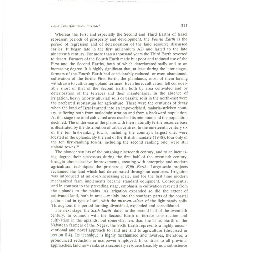
present-day Libya.Land Transformation in Israel 311 Whereas the First and especially the Second and Third Earths of Israel represent periods of prosperity and development, the Fourth Earth is the period of regression and of deterioration of the land resource discussed earlier. It began late in the first millennium AD and lasted to the late nineteenth century. For more than a thousand years the Third Earth reverted to desert. Farmers of the Fourth Earth made but poor and reduced use of the First and the Second Earths, both of which deteriorated sadly and to an increasing degree. It is highly significant that, at least during the later stages, farmers of the Fourth Earth had considerably reduced, or even abandoned, cultivation of the fertile First Earth, the plainlands, most of them having withdrawn to cultivating upland terraces. Even here, cultivation fell consider- ably short of that of the Second Earth, both by area cultivated and by deterioration of the terraces and their maintenance. In the absence of irrigation, heavy (mostly alluvial) soils or basaltic soils in the north-east were the preferred substratum for agriculture. These were the centuries of decay when the land of Israel turned into an impoverished, malaria-stricken coun- try, suffering both from maladministration and from a backward population. At this stage the total cultivated area reached its minimum and the population declined. The under-use of the plains with their naturally fertile resource base is illustrated by the distribution of urban centres. In the nineteenth century six of the ten first-ranking towns, including the country's largest one, were located in the uplands. By the end of the British mandate (1948), four only of the ten first-ranking towns, including the second ranking one, were still upland towns.34 The pioneer settlers of the outgoing nineteenth century, and to an increas- ing degree their successors during the first half of the twentieth century, brought about decisive improvements, creating with enterprise and modem agricultural techniques the prosperous Fifth Earth. Large-scale projects reclaimed the land which had deteriorated throughout centuries. Irrigation was introduced at an ever-increasing scale, and for the first time modem mechanized farm implements became standard equipment. Consequently, and in contrast to the preceding stage, emphasis in cultivation reverted from the uplands to the plains. As irrigation expanded so did the extent of cultivated land, both in area-mainly into the southern parts of the coastal plain-and in type of soil, with the mise-en-valeur of the light sandy soils. Throughout this period farming diversified, expanded and consolidated. The next stage, the Sixth Earth, dates to the second half of the twentieth century. In common with the Second Earth of terrace construction and cultivation in the uplands, but somewhat less than the Third Earth of the Nabatean farmers of the Negev, the Sixth Earth represents a highly uncon- ventional and novel approach to land use and to agriculture (discussed in section 8.4). Its technique is highly mechanized and involves, therefore, a pronounced reduction in manpower employed. In contrast to all previous approaches, land now ranks as a secondary resource base. By now subsistence
312                                           Land Transformation in Agriculture

agriculture is a matter of the past. The market directs agricultural planning.
The possibility of introducing out-of-season agriculture in the Negev in order
to produce during the winter fresh products for the European market makes
the climate-especially      high temperatures coupled with clear skies-the
first-ranking resource, and shifts regional preferences once more into the
Negev, although into areas different from those of Nabatean agriculture. Soil
is cultivated irrespective of the inherent risk of flooding, and water is piped to
the optimal place of use rather than made use of where it occurs in nature.
   Elsewhere in Israel, the National Water Carrier ranks water higher than
soil as a resource in farming. It is used where each cubic metre gives the
highest return. In extreme cases, soil too is used as an artificial resource, not
in loco, but at the climatically optimal location in greenhouse farming. This
 again tends to give regional preference to the north-western Negev with its
 clear skies. In addition to advanced genetic research improving strains of
 crops, chemicals have largely taken over as fertilizers and pesticides, both for
convenience of handling and in particular to intensify cultivation. This obvi-
 ates, if so desired, the need for crop rotation. The intensive use of chemicals
 has placed a premium on light, permeable and chemically neutral soils which
 retain a minimum of the chemicals applied. Pure sandy soils, including dune
 areas formerly considered of no agricultural value, are now particularly in
 demand. Therefore, the coastal dunes came into the orbit of agriculture, as
 did the inland dune areas of the northern Negev. The increase of intensity of
 cultivation, more discriminating as regards the properties of the soil, restricts
 cultivation to the more desirable soils and reduces to a certain degree the total
 cultivated area. Yields and size of crop are no longer determined mainly by
 the size of area cultivated, but rather by modern agricultural technology, its
 chemicals and genetic improvements.
    After the end of the First World War a very different type of land use and
 land transformation emerged, making gradually increasing demands for often
 potentially fertile and even cultivated land. This is the urbanized Seventh
 Earth. As about 90% ofthe population require this type of land use today, the
 tendency for and pressure of its expansion are considerable. To quote Higbee
 (1952): 'What is of value to urban man is tended to satisfy his wants and suit
 his tastes; the rest is neglected.' In view of the fact that much of the land
 involved in urban transformation is of prime agricultural value, this is a matter
 of considerable national concern.

      8.8 REVERSIBLE AND IRREVERSIBLE CHANGES OF LAND USE

An attempt was made in section 8.7 to show how different populations
employing different agro-technologies utilize the same land. We have seen
times of improvement and of positive changes in land use alternating with
times of deterioration, and even of desertification. The example of Israel
You can also read