D1.2 Current and future uses and needs of the European Atlantic region - August 2021
←
→
Page content transcription
If your browser does not render page correctly, please read the page content below
D1.2
Current and future uses
and needs of the
European Atlantic region
August 2021

                           i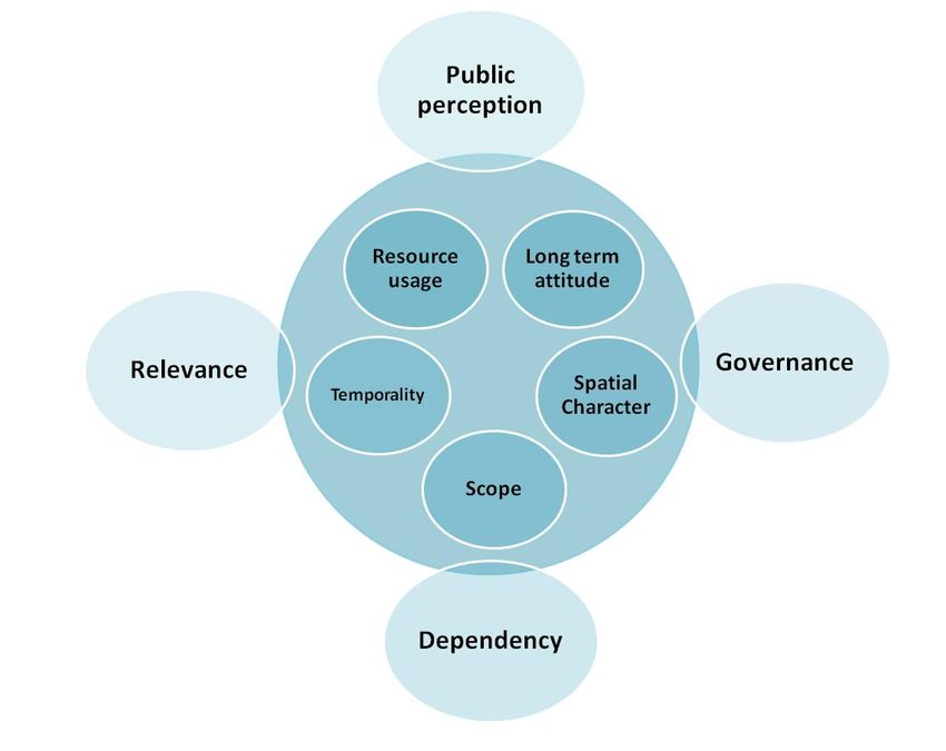
SIMAtlantic:
Supporting implementation of maritime spatial planning in the Atlantic region

EU project officer: David San Miguel Esteban
Project coordinator: University College Cork
Project start date: 1 July 2019
Project duration: 27 months

Document title: Current and future uses and needs of the European Atlantic region
Date: August 2021
Version: Version 3

Authors

Cristina Cervera Núñez (IEO), Mónica Campillos Llanos (IEO) Julien Dilasser (CEREMA), María Gómez
Ballesteros (IEO)

Acknowledgements

Kevin Hamill (DAERA), Victoria Poppleton (AFBI), Anne Marie O’Hagan (UCC)

Recommended citation

Cervera-Núñez, C., Campillos-Llanos, M., Dilasser, J., Gómez-Ballesteros, M. 2021. Current and future
uses and needs of the European Atlantic region. Deliverable 1.2 of the SIMAtlantic project
(EASME/EMFF/2018/1.2.1.5/SI2.806423). 35pp.

Disclaimer: This document was produced as part of the SIMAtlantic project (Grant Agreement:
EASME/EMFF/2018/1.2.1.5/SI2.806423-SIMAtlantic). The contents and conclusions of this document,
including any maps and figures, were developed by the participating partners with the best available
knowledge at the time. They do not necessarily reflect the national governments’ positions and are
therefore not binding. This document reflects only the SIMAtlantic project partners’ view and the
European Commission or Executive Agency for Small and Medium-sized Enterprises is not responsible
for any use that may be made of the information it contains.

                                                                                                    ii
Table of contents
Table of figures ..................................................................................................................................... i
Table of tables ....................................................................................................................................... i
Acronyms.............................................................................................................................................. ii
1    Rationale and purpose ............................................................................................................... 1
2    State of the art ............................................................................................................................ 2
  2.1     Potential interactions ........................................................................................................ 20
3    Approaching activities’ interaction by building scenarios: a proposed method to strategic
     thinking ...................................................................................................................................... 22
  3.1     Uses characterization ....................................................................................................... 23
     3.1.1     Internal characteristics ............................................................................................. 24
     3.1.2     External characteristics ............................................................................................ 26
     3.1.3     Characterizing the interaction by building micro-scenarios................................. 27
     3.1.4     Targeted approach ................................................................................................... 28
4    SWOT analysis of the method ................................................................................................ 30
  4.1     Strengths............................................................................................................................ 30
  4.2     Weaknesses ....................................................................................................................... 30
  4.3     Opportunities ..................................................................................................................... 31
  4.4     Threats ............................................................................................................................... 31
5    Final observations .................................................................................................................... 31
References ........................................................................................................................................ 34
Annex I – Scenario development examples
Annex II – Virtual test – Wind energy vs fisheries in the Galician coast

Table of figures
Figure 1. TPEA conflict matrix. Source: TPEA project, 2014. ..................................................... 21
Figure 2. Conceptual model for characterizing uses. Source: Own elaboration. ..................... 24
Figure 3. Interaction matrix. Source: Own elaboration. ............................................................... 28

Table of tables
Table 1. Internal characteristics and values .................................................................................. 24
Table 2. External characteristics and values ................................................................................. 26
Table 3. Potential types of building blocks .................................................................................... 29

                                                                                                                                                        i
Acronyms
AAC – Aquaculture Advisory Council
CFP - Common Fisheries Policy
EIA – Environmental Impact Assessment
EIP – European Innovation Partnership on raw materials
EMFAF – European Maritime Fisheries and Aquaculture Fund
EMFF – European Maritime and Fisheries Fund
ENTSO – E – European network of transmission system operators for electricity
ESCA – European Subsea Cables Association
EU – European Union
ICPC – International Cable Protection Committee
IOGP – International Association of Oil and Gas Producers
IMO – International Maritime Organization
IMP – Integrated Maritime Policy
IPCC – Intergovernmental Panel on Climate Change
MPA – Marine Protected Area
MRE - Marine Renewable Energy
MSFD – Marine Strategy Framework Directive
MSP – Maritime Spatial Planning
O&G – Oil and Gas
OWF – Offshore Wind Farm
PCI – Projects of Common Interest
SIMAtlantic – Supporting Implementation of maritime spatial planning in the Atlantic region
SIMCelt - Supporting Implementation of Maritime Spatial Planning in the Celtic Seas
SIMNORAT – Supporting the Implementation of Maritime Spatial Planning in the North
Atlantic Region
TEN – E – Energy corridors identified by EU to support the development of energy
infrastructure
TSS – Traffic Separation Schemes
UNCLOS – United Nations Convention on the Law of the Sea
UNCTAD – United Nations Conference on Trade and Development
WPC – World Petroleum Council
WTO – World Trade Organization

                                                                                              ii
1 Rationale and purpose
One of the main goals MSP seeks to achieve is compatibility of activities and uses, reducing
conflicts and fostering synergies in one particular area in order to achieve the most efficient
use of the space by identifying the best position on the sea where a human activity can be
carried out according to ecological, economic and social variables (IOC-UNESCO, 2009;
European Union, 2014). Furthermore, it not only aims to deliver coexistence of particular
uses at a particular time, but also the maintenance of this coexistence in the long term, even
with the arrival of new maritime activities and uses, considering also emerging sectors.
These idyllic objectives normally imply the need to use the best data and information
available, first, regarding current activities and the interactions among them and secondly,
when talking about the long term, data on trends and future projections. The first aspects
related to the present, although complex, are fairly achievable, however, when we talk about
assessing the future, the issue gets more complicated and any result or outcome becomes
less certain, the error range growing considerably.
Consequently, knowledge or data gaps appear many times during the process, as decision
making in MSP needs to be focused on “the best available knowledge” (MSPD, EU, 2014)
trying to avoid, to the maximum extent, uncertainty. But what if the best available knowledge
is full of gaps and uncertainties? The real context in which this study is developed (COVID-19
pandemic) highlights the fact that the approach should be enlarged to include uncertain
situations, as assumptions that were normally made, nowadays might not correspond to
reality.
It is reasonable to have the willingness to work with the greatest possible certainty and with
the maximum of quantified data possible. However, we should remember that MSP is not an
exact science and that it is happening temporally and within a dynamic space, involving
numerous actors, at different scales, of different kinds (private and public) and from different
sectors. Therefore, we cannot just acknowledge and identify gaps and uncertainties; we have
to deal with them. Consequently, there is a need for developing tools for decision making that
work well in uncertain environments as lack of data cannot be a reason for inaction (IOC-
UNESCO, 2009).
However, how do we work with something that we do not know? It is here that the design of
exploratory (qualitative) scenarios to understand strategic issues (Borjeson et al, 2006 in
McGowan et al 2018) plays an important role, not only in the present to test potential
measures or answers to existing issues, but also to prevent future issues or to promote
synergies. Exploratory scenarios consider “what can happen?” given a set of plausible
futures (McGowan et al., 2018). It may not be possible to predict a certain future but we could
design a potential future regarding for instance, a specific interaction between uses, analyze
their implications, and thus, propose measures in the present that could prevent conflicts and
maximize synergies in the future.
Considering all these aspects, the purpose of this task is to provide framework information
and guidelines for the improvement of integration between activities in the project area by
focusing on the prevention of potential future conflicts and promotion of possible synergies.
This was proposed to be achieved by two complementary approaches:
• A background review of existing analyses and past initiatives (i.e. SIMNORAT and
SIMCelt outputs) related to maritime activities and strategies at regional level. This
1work has been developed in order to have a “state of art” or a “picture” regarding
uses and activities in the area. The output of this subtask is structured as factsheets of
maritime sectors presenting basic facts of the sector in the project area and providing
sources of more information.
• A decision support tool has been developed to address interactions between
activities. This method is based on permanent characteristics of the activities, but also
in their surrounding changing context, being flexible enough so these characteristics
can define a specific interaction scenario in the most realistic way possible.
This task did not collect new information but rather capitalized on previous studies in the
area, combining and reflecting on their outputs to develop a practical product.
2 State of the art
This section provides basic facts about maritime activities in the area, their characteristics
and their contexts, insights to understand main drivers of status and trends of each sector in
the project area. Different sections are developed for each maritime sector:
• Specific characteristics: Basic facts that define the sector in the project region.
• State of the sector: General state of actual trend of the sector in the project region.
• Relevance across jurisdictional zones: Aspects of the sector that makes it relevant for
MSP in the project region.
• Interaction with other uses: Potential interactions and aspects that define them.
• Governance arrangements: Governance systems in place for the sector in the project
region.
• Sector specific strategies: Relevant strategies in the project region for the sector (if
any)
• Future perspectives: Compilation on future perspectives concluded from previous
studies and consultations
• Further information: Sources of more detailed information for the aspects contained in
the table
FISHERIES
Specific characteristics
• Wide variety of fishing vessels, fishing techniques and large number of fish species
targeted. Those different types of fisheries will be treated in common in this state of
the art.
• General pattern of dominant small-scale fishing in the south and deep-sea fishing
more important in the north.
State of the sector
• Reduction of fishing effort and fishing fleet, due to different factors: overfishing, stock
fluctuations, combat against the overexploitation of resources and to protect
spawning grounds.
2Relevance across jurisdictional zones
• Historically an important activity for all the countries of the SIMAtlantic study area
with a long tradition of spatial claims.
• Fishing activities are present throughout the study area.
• Concern among fishers that they may lose access to their current fishing grounds
• The redeployments of fisheries caused by the growth of new activities are carried
out to areas which are already over-utilised or host sensitive environment
Interactions with other uses
• Spatial demand for the professional fishing sector is already high. With the growth of
new maritime uses, the need for greater sharing of space means that there could be
more potential for conflict.
• Fishermen’s concerns regarding the development of permanent occupation of the
maritime zones for the installation of structures, such as some renewable energy at
sea, aquaculture or the installation of underwater cables and structures that could
prohibit the use of certain fishing gears and total exclusion.
• Impacts on the marine environments from the collection of species (sometimes
overfishing 1) and the destruction of ecosystems by different types of gear.
Governance arrangements
• Several organizations representing the interests of fishing professionals at European
and at national & local levels.
• Exclusive competence of the European Union for conservation of marine biological
resources under the Common Fisheries Policy (CFP) and shared competence with
Member States for fisheries generally (except marine biological resources) and for
the environment.
Sector specific strategies
• United Nations Convention on the Law of the Sea (UNCLOS) and Straddling Stocks
Agreement.
• Common Fisheries Policy (CFP) and associated Regulations (including area-based
management measures).
• European Maritime, Fisheries and Aquaculture Fund (EMFAF)
• Atlantic Strategy. The Commission intends to propose an appropriate framework as
soon as the CFP reform is finalised.
Future perspectives (if clearly identified)
• Several elements could lead to a modification of the fishing zone for part of the
fishing activities: the increase of restrictive measures to preserve important fish
1
OurFish (2017) & STECF (2017) in https://www.msp-platform.eu/sector-information/fishing
3habitat as part of management policies 2 (such as the CFP); a growing need for space
sharing due to the rise of other activities; agreements between countries (such as
Brexit agreement); climate change is expected to lead to more extreme weather
conditions as well as rapid warming of waters and acidification.
• The reduction in the number of fleets, the implementation of sustainable fisheries
management and the accelerated use of selective fishing is expected to have
positive effect on European fish stocks in the medium term. It could lead to an
increase in the gross value added (GVA) of the fishing sector and the possible
extension into areas not utilised to date for fisheries.
Further information
• SIMNORAT D8: Spatial demands • SIMCelt D3c: Overview Report on the
and future trends for maritime Current State and Potential Future
sectors and marine conservation Spatial Requirements of Key Maritime
Activities
• SIMNORAT D1: Initial Assessment
Developing an Overview • https://www.msp-platform.eu/sector-
information/fishing
• https://oap.ospar.org
SHIPPING
Specific characteristics
• The sector depends more on fluctuations in economic markets. 3
• Mature sector of Europe’s maritime economy, contributing to high levels of gross
value added (GVA) and employment in Member States. 4
• Marine traffic routes are defined by international law (i.e. International Maritime
Organization - IMO). In addition, the European Union introduced the concept of
Motorways of the Sea in the White Paper on Transport in 20015.
State of the sector
• Despite in some specific cases (ferry passenger transport in UK, Ireland and France)
the sector, in general (including cruises), has shown a general trend of growth and it
is expected that this trend will continue in the near future.
• Additional and new ferry routes have commenced between Ireland and mainland
Europe this year (2021) as a result of the UK’s departure from the EU.
Relevance across jurisdictional zones
• Shipping takes place throughout the SIMAtlantic maritime area.
2
Fishermen interviews in SIMNORAT D8: Spatial demands and future trends for maritime sectors and marine
conservation
3
Frémont & al. 2013
4
Ecorys, 2014 in SIMCelt 2017
5
Available at: https://ec.europa.eu/transport/themes/strategies/2001_white_paper_en
4• Highest densities of ship traffic are found in the English Channel and at the entrance
to the Mediterranean Sea.
• Several traffic separation schemes (TSS) are in place in the project area.
Interaction with other uses
• There is increasing competition and spatial demand for shipping and wind farms.
The main concerns here relate to safety of navigation, the prevention of accidents
and pollution.
Governance arrangements
• European Community Shipowners’ Associations (ECSA)
• International Maritime Organization (IMO).
• Cruise Lines International Association (CLIA).
Strategies, initiatives and legal arrangements
• European Commission: Integrated Maritime Policy and Sustainable Blue Economy.
• Short Sea Shipping.
• Motorways of the Sea.
• Atlantic Strategy and Action Plan.
• Each member state in the SIMAtlantic study develops its own public policies in
support of the development of ports and maritime transport.
Future perspectives (if clearly identified)
• The use of larger vessels and the effects of rerouting could affect the demand for
space in the commercial transport sector, which is currently experiencing strong
global growth in traffic and thus freight volume.
• Current transport policies advocating greater development of maritime transport in
intra-European transport are opportunities for the development of short sea shipping,
which also affects marine space.
• Climate change makes weather routing important, and the space needs to be
available.
• Increased deployments of marine renewable energy devices may result in increased
competition for port access and space, adding to pressures on coastal locations and
space for shipping/transport.
Further information
• SIMNNORAT D8: Spatial demands and • SIMCelt D3c: Overview Report on
future trends for maritime sectors and the Current State and Potential
marine conservation Future Spatial Requirements of Key
Maritime Activities
• SIMNORAT D1: Initial assessment:
developing an overview • Ecorys, 2011 in SIMCelt (2017).
5• SIMCelt D1: Initial Assessment • https://oap.ospar.org
Developing an Overview
• https://www.msp-
platform.eu/sites/default/files/sector
/pdf/mspforbluegrowth_sectorfiche
_shippingports.pdf
MARINE AGGREGATES
Specific characteristics
• The marine aggregates sector considers the exploration, exploitation and extraction
of marine sediment from the seabed, mainly sand and gravel, for potential use in
construction, beach nourishment/coastal protection or filling purposes. Agricultural
soil improvement is a less common way.
State of the sector
It depends on the country, however, there are some commonalities:
• The restrictive regulatory framework for obtaining exploitation rights for marine
aggregates is presented as an obstacle to the development of the activity.
• In any case, there are not enough defined arguments to state that the activity is
growing or in decline, so we can assume a stagnant situation.
Relevance across jurisdictional zones
• Extraction of aggregates occurs off the North-West and South-West of England6.
There is currently no commercial extraction of marine aggregates in Ireland,
Scotland and Northern Ireland. France extracts marine aggregates for construction.
On the other hand, in Spain extraction of aggregates for construction is specifically
forbidden and the activity is only allowed for beach nourishment and in port related
dredging, and in that case is subject to an Environmental Impact Assessment (EIA).
• Different reasons (e.g. beach nourishment and port maintenance) make this use a
necessary activity in every country that has spatial implications and relevance in the
context of MSP.
• For the sake of cost of marine aggregates, it is likely that any increase in the number
of applications for authorizations for new extraction sites will be limited to nearshore
areas.
Interaction with other uses
• During extraction, all other uses are to be spatially avoided so that focus remains on
a safe exploration 7.
• During dredging activity, conflicts exist with regard to access to fishing grounds and
deployment of fixed fixing gear.
6
ICES, 2012
7
Comment from British Marine Aggregates Producers Association in https://www.msp-
platform.eu/sites/default/files/sector/pdf/mspforbluegrowth_sectorfiche_marineaggregates.pdf
6• Marine mining potentially causes environmental damage to biological diversity and
ecosystems and can conflict with designated sites under the EU Birds and Habitats
Directives and other Marine Protected Areas.
Strategies, initiatives and legal arrangements
• The Atlantic strategy aims to develop the sustainable exploitation of the natural
resources of the Atlantic seabed.
• EU industrial strategy: In March 2020, the Commission adopted an EU industrial
strategy to address the twin challenges of the green and the digital transformation.
• European Innovation Partnership on raw materials (EIP)º
• ERA-MIN (Network on the industrial handling of raw materials for European
industries) & ERA-MIN2
• The Raw Materials Initiative.
Future perspectives
• Increasing demand for construction materials, maintenance of port activities. In
addition, availability of aggregates resources becomes constrained on land.
• Coastal defence: Because of climate change impacts and rising sea levels, demand
for sediments is likely to increase in the next few years where most beach and
coastal areas are experiencing increases in erosion.
• However, regulatory obstacles to obtaining new exploitation rights and the negative
interactions with other activities are issues that may reduce the potential growth of
the activity.
• The increasing scarcity of supply of raw and non-living materials, tends to push some
countries (i.e., UK and France) out into deeper waters further offshore to look for
new supply zones.
Further information
• SIMNORAT D8: Spatial demands • SIMCelt D3c: Overview Report on the
and future trends for maritime Current State and Potential Future
sectors and marine conservation Spatial Requirements of Key Maritime
Activities
• SIMNORAT D1: Initial assessment:
developing an overview • https://oap.ospar.org
• SIMCelt D1: Initial Assessment • https://www.msp-
Developing an Overview platform.eu/sites/default/files/sector/pdf/
mspforbluegrowth_sectorfiche_marineag
gregates.pdf
MARINE RENEWABLE ENERGY
Specific characteristics
• This sector is represented mainly by offshore wind energy industrial developments
as other kinds of offshore renewable energies in the region are in testing and
7research phases. Although southern countries in the project area have great
potential, there is a clear difference with the more developed sector in the north.
• Bathymetry and swell criteria remain constraints for the development of the sector in
the near future.
• Fixed platforms and cables present until decommissioning.
State of the sector
• Recent years have seen a significant increase in the amount of renewable energy
development in the SIMAtlantic project area, mostly in the northern area for offshore
wind energy.
• Energy from the conversion of tidal and wave resources is also being developed but
at a pre-development stage.
• In relation to offshore wind, floating technologies are also being developed and
deployed and are expected to increase in the coming years.
Relevance across jurisdictional zones
• The harnessing of offshore renewable energies is crucial to achieving international,
European and national commitments in line with energy transition and in the fight
against climate change. Marine renewable energies, in particular offshore wind,
could be an important contributor to this.
• Offshore wind farm development has been most intense in the waters of North West
England and the Irish Sea. Offshore wind is currently the predominant technology
deployed in the Celtic Seas. Projects in French and Irish waters are in the planning
stage.
• In the South project area, despite of a high potential, marine renewable sector is still
at its infancy and its development is taking place at a slower pace than expected.
Spain has a great potential for offshore wind potential but at the time of writing, no
commercial offshore wind farms (OWF) have been developed, though this situation
is expected to change due to the current MSP process and the new Law of Climate
Change and Ecological Transition that was just approved.
Interaction with other uses
• It seems that there can be strong public objections to certain offshore energy
developments (and probably the tourism and recreational sectors) with wind farms
are more difficult to develop closer to shore 8 where there are impacts on the
aesthetic environment/seascape.
• Wind farms, as permanent installations, might conflict with activities such as fisheries
and maritime transport.
8
Interview with Maritime Industry/Energy representative in France in SIMNORAT D8: Spatial demands
and future trends for maritime sectors and marine conservation
8Governance arrangements
• There are roughly two types of processes currently used in the development of
offshore wind farms. The government “call for tender process” and the “open door
process”. The former is usually led by a competent authority whereas the latter
tends to be developer led on a case-by-case basis. In practice, each country has its
own policy and procedures, differing slightly from these general processes. The
choice of approach not only influences what kind of zones (search zones, tender
zones) are developed in an MSP, but also how the energy transport from OWF to
land is arranged.
Strategies, initiatives and legal arrangements
• Paris Agreement (2016)
• Renewable Energy Directive 2009/28/EC; EU – Energy Road map 2050
• Atlantic Strategy and Atlantic Action Plan
• European Integrated Maritime Policy and Sustainable Blue Economy Agenda.
• The European Green Deal
• An EU Strategy to harness the potential of offshore renewable energy for a climate
neutral future (COM(2020) 741 final)
Future perspectives (if clearly identified)
• Offshore wind farm construction is largely driven by international commitments for
carbon reduction, such as the Paris agreement. EU law and policy developments are
also an important stimulus. A significant expansion of the production of offshore wind
energy is therefore expected over the next decades, with an increasing number of
offshore wind farms being built and planned.
• Technological advances (such as floating technologies) enable deeper water
installations allowing OWFs to be sited further offshore and in previously inaccessible
locations.
• Commercialisation of wave energy conversion technology could result in major
spatial implications in areas where wave resource is present.
• In some countries there are difficulties relating to public acceptance of large-scale
offshore wind developments. It is therefore important that stakeholders are engaged
and participate early in the planning process.
Further information
• SIMNORAT D8: Spatial demands • SIMCelt D3c: Overview Report on the
and future trends for maritime Current State and Potential Future
sectors and marine conservation Spatial Requirements of Key Maritime
Activities
• SIMNORAT D1: Initial assessment:
developing an overview • SIMCelt D2c: Offshore Wind Briefing
Note
• SIMCelt D1: Initial Assessment
Developing an Overview • https://oap.ospar.org
9• https://www.msp- • https://www.msp-
platform.eu/sites/default/files/sector platform.eu/sites/default/files/sector/pdf/
/pdf/mspforbluegrowth_sectorfiche mspforbluegrowth_sectorfiche_offshorew
_tidalwave.pdf ind.pdf
OIL & GAS
Specific characteristics
• Fixed platforms and pipelines present until decommissioning and may not be fully
removed from the seabed.
• The attractiveness of the sector is influenced by a number of geo-political factors
particularly crude oil price.
• The competition with other energy sources affects the oil and gas sector, in
particular the development of renewable marine energies in a context of increasing
emphasis on emission reductions
State of the sector
• Mature and declining activity.
• Accompanied by the decarbonization policies of the Member States: e.g. exploration
and exploitation of hydrocarbons prohibited by law in France 9 , Spain 10 and a similar
bill underway in Ireland. 11
Relevance across jurisdictional zones
• The activity is more present in the Celtic seas even if it remains modest. Most of
these sites are located in the North Sea, with small-scale production in the eastern
Irish Sea and in Shetland (Scotland) and south of Ireland (Cork).
• The oil and gas sector is locked in physically to the specific location where
geological processes lead to those materials to be extracted. Thus, the spatial aspect
is of the greatest importance for these sectors, as the spatial availability of the
resource cannot be altered. At the same time, a re-allocation of the activity would
therefore not be possible.
9
French law N° 2017-1839 du 30 décembre 2017 mettant fin à la recherche ainsi qu'à l'exploitation des
hydrocarbures et portant diverses dispositions relatives à l'énergie et à l'environnement available at:
https://www.legifrance.gouv.fr/loda/id/JORFTEXT000036339396/
10
Spanish Law 7/2021, de 20 de mayo, de cambio climático y transición energética, available at:
https://boe.es/buscar/act.php?id=BOE-A-2021-8447
11
Irish government press release available at: https://www.gov.ie/en/press-release/ee960-government-to-
introduce-legislation-to-ban-new-oil-and-natural-gas-exploration-and-extraction/
10Interaction with other uses
• Some potential for multi-use e.g., sharing platforms with Marine Renewable Energies
(OWF).
• Safety zones around the sites excluding any other activity such as fishing.
• Potential significant ecological consequences even if oil spills are of increasingly low
risk. Also, potential disturbance of marine mammals during seismic uses in
exploration phases.
• Additional environmental impacts from full decommissioning.
Governance arrangements
A large number of international organizations directly or indirectly influence the sector such
as:
• World Petroleum Council (WPC) • United Nations Conference on Trade and
Development (UNCTAD)
• International Association of Oil and
Gas Producers (IOGP) • World Trade Organization (WTO)
• International Maritime Organization • Intergovernmental Panel on Climate
(IMO) Change (IPCC)
• At the national level, sectors have been organized into federations integrating most
companies developing exploration and production activities.
Strategies, initiatives and legal arrangements
• OSPAR recommendation 2003/5 which promotes the use of environmental
management mechanisms by the Offshore oil & gas industry.
• National Governments strategies which have control over the area which companies
install exploitation sites.
• The European Green Deal
• MERMAID (Innovative Multipurpose offshore platforms: planning, design & operation)
Future perspectives (if clearly identified)
• Demand for oil and gas is linked to the economic cycle. New environmental policies
such as the Paris Agreement are calling for a reduction in European CO2 levels,
compelling countries to turn to renewable energy resources such as offshore wind or
tidal energy.
• With the combination of climate change policies and legislation, the Marine Strategy
Framework Directive (MSFD) and the projected increase in MPAs, it is likely that oil
and gas production will become less attractive due to new constraints.
Further information
• SIMNORAT D8: Spatial demands • SIMCelt D3c: Overview Report on the
and future trends for maritime Current State and Potential Future
sectors and marine conservation
11• SIMNORAT D1: Initial assessment: Spatial Requirements of Key Maritime
developing an overview Activities
• SIMCelt D1: Initial Assessment • https://oap.ospar.org
Developing an Overview
• https://www.msp-
platform.eu/sites/default/files/sector/pdf/
mspforbluegrowth_sectorfiche_oilgas.pdf
AQUACULTURE
Specific characteristics
• The presence of aquaculture activity varies widely across the SIMAtlantic project
area. Most finfish aquaculture occurs in Scotland and Ireland, whereas aquaculture
for shellfish is more widespread and is found mainly on the French and Spanish
coasts.
• Within the project area, the main aquaculture species include Atlantic Salmon, which
is the main product of Scottish aquaculture, and mussels in Ireland, Wales, Spain
and France. 12
State of the sector
• The aquaculture sector in Europe has been described as ‘stagnating’, due to its lack
of growth compared to the aquaculture sector globally. Therefore, it became a
priority sector for the European Union’s Blue Growth agenda as well as for the new
approach for sustainable blue economy, with concerted efforts to stimulate
development and sustainability. 1314
• In Portugal, the number of active establishments located at sea is still low and seems
to show significant growth potential.
Relevance across jurisdictional waters
• The predominant marine farming methods in the SIMAtlantic seas include, in large
part, the farming of Atlantic salmon in enclosures and crustaceans, including the
cultivation of shellfish in coastal / marine aquaculture facilities. (i.e., on trestles,
ropes, “bouchot” poles or in netting) or grown on the seabed.
• Depending on the operating methods, the installation of aquaculture sites, notably
bivalves, is constrained by physical factors (geomorphology of the coasts,
bathymetry) and by the good ecological status of the water and water quality.
• These constraints are exacerbated by the development of new activities on the coast
(in particular land-based activities such as yachting or certain MRE). The sector is
therefore concerned with the challenges of preserving existing sites as much as with
the search for new sites. 15
12
ABPmer, 2016
13
Ertör and Ortega-Cerdà, 2015
14
https://eur-lex.europa.eu/legal-content/EN/TXT/HTML/?uri=CELEX:52021DC0240&from=EN
15
Interview with French aquaculture stakeholders in SIMNorat D8: Spatial demands and future trends
12Interaction with other uses
• Pressures associated with aquaculture include: physical damage to the seabed,
pollution/chemical changes to the water column (mainly for finfish aquaculture16),
disease and parasites, escapes (interaction with wild stocks), carrying capacity /
nutrient cycling.
• Conflicts relating to access of space mostly occur with beach tourism, shipping, oil
and gas and marine aggregates and mining sectors. Synergies can be developed
with tourism, renewable energy production and environmental protection 17
Governance arrangements
• Aquaculture Advisory Council (AAC) composed of representatives from industry and
other stakeholders to provide recommendations and advice to Member States and
other European Institutions.
• National and local associations of professionals.
Strategies, initiatives and legal arrangements
• Aquaculture was a development axis for Blue Growth within the European Union and
keeps its importance in the new approach to Sustainable Blue Economy. It is
therefore supported by several international, national and local policies and
strategies.
• Common Fisheries Policy (CFP), Reforms of the CFP and the European Maritime and
Fisheries Fund (EMFF), now European Maritime Fisheries and Aquaculture Fund
(EMFAF) have introduced a framework to accompany a marked increase in
aquaculture production across the EU18.
• Strategic Guidelines for the sustainable development of EU aquaculture.
• The European Green Deal
• Atlantic strategy
• National sectoral strategies
Future perspectives (if clearly identified)
• Simplifying administrative procedures for aquaculture development: Under reforms
to the Common Fisheries Policy, it is recommended that all European Member
States produce Multiannual National Plans based around the themes of simplifying
administrative procedures for aquaculture development.
• Growing demand for aquaculture products: Aquaculture production must increase
within Europe in order to satisfy the increasing demand for seafood, coupled with
reduced catches, decrease the dependence from importation, boost economic
development and job creation, and reduce pressure on fish stocks19.
16
STECF 2015
17
https://www.msp-platform.eu/sites/default/files/sector/pdf/mspforbluegrowth_sectorfiche_aquaculture.pdf
18
European Commission, 2013a
19
Douvere and Ehler, 2009; Ertör and Ortega-Cerdà, 2015; FAO, 2012
13• As a result, the sector is likely to increase its spatial requirements in the coming
years, including moving to more offshore areas. Offshore expansion could be
facilitated by synergies with other offshore maritime sectors, in a multi-use context.
Further information
• SIMNORAT D8: Spatial demands • SIMCelt D3c: Overview Report on the
and future trends for maritime Current State and Potential Future
sectors and marine conservation Spatial Requirements of Key Maritime
Activities
• SIMNORAT D1: Initial assessment:
developing an overview • SIMCelt D2a: Aquaculture Briefing Note
• SIMCelt D1: Initial Assessment • https://oap.ospar.org
Developing an Overview
• https://www.msp-
platform.eu/sites/default/files/sector/pdf/
mspforbluegrowth_sectorfiche_aquacultu
re.pdf
YACHTING & MARITIME TOURISM
Specific characteristics
• The analysis of the spatial demands for recreational and water sports is complex.
Indeed, this element is mainly based on multiple practices carried out by individual
boaters to which are added many federations and professional practitioners.
• The concept of navigation basins is complex and takes different forms depending on
the practices and regions.
• In addition, the data of the sports federations, which regroup the licensees and the
occasional practitioners (within the framework of the federations), bring only a partial
light on the analysis of the practice of the nautical activities.
State of the sector
• A mature and growing activity.
• Current trends in the industry in the Member States are leading to an increase in the
number of vessels on the coastlines and increase in the number of users of the
various practices and the development of many new practices in recent decades.
Relevance across jurisdictional zones
• The sector is often associated with the onshore tourism sector (number of overnight
stays or financial contributions for a territory) without making the link between this
tourist activity and the spatial involvement at sea.
• In most practices, the maritime and coastal tourism sector is a spatially limited
activity. The practice of the light leisure activities remains limited to areas closest to
the shore and only few boaters leave the territorial sea where all the navigation
basins are registered 20.
20
Sonnic, 2008
14• In numbers of cases maritime activities are area based e.g., surf spot, snorkelling
and scuba diving sites.
• The spatial demands of the representatives of the various nautical and recreational
practices are expressed, for the most part, in the form of the defence of the freedom
of navigation. The sea is presented as a space of freedom to preserve.
Interaction with other uses
• A concentration of activities in the coastal strip which may lead to local conflicts:
tourism, sailing and nautical activities, small-scale fisheries, aquaculture and
recreational fishing and an emerging issue with renewable marine energy projects.
• Coastal tourism may lead to negative land-sea interactions and water quality issues,
increase waste generation and energy and water consumption, exacerbate the
exploitation of biological and other resources and ultimately lead to more pollution
and a serious deterioration of marine and coastal ecosystems.
• Conversely, even when coastal tourism does not share the same space with other
activities, the environmental impacts of other sectors can affect coastal tourism.
Governance arrangements
• Number of different institutions from public authorities to stakeholder
representatives: user associations, sports federations, tourism development
representatives.
Strategies, initiatives and legal arrangements
• National and local tourism development strategies
• Blue Growth agenda (coastal tourism).
Future perspectives (if clearly identified)
• Forecasts indicate a significant increase in recreational boating associated with the
growth of coastal tourism where tourism associated with nautical activities is
expected to increase significantly over the next few years. The demand for additional
infrastructure and services / activities is therefore likely to increase.
• Practices should turn more and more towards the use without possession of vessels
with the development of leasing. These changes are reflected in particular in a
reduction in the demand for moorings, which could lead to the gradual release of
berths currently occupied by “stationary boats”, some ports are already anticipating
these changes.
• These new forms of practice, moving towards a sort of “Uberization” of marine
recreational uses, will increase the need to promote good practices towards new
groups of users who are less aware of the interactions between uses and
environmental issues.
• The technical evolutions (power of the engines, GPS, safety equipment) are
susceptible to enlarge the area of navigation by ensuring a better security to the
boaters.
15Further information
• SIMNORAT D8: Spatial demands • SIMCelt D3c: Overview Report on the
and future trends for maritime Current State and Potential Future
sectors and marine conservation Spatial Requirements of Key Maritime
Activities
• SIMNORAT D1: Initial assessment:
developing an overview • https://oap.ospar.org
• SIMCelt D1: Initial Assessment • https://www.msp-
Developing an Overview platform.eu/sites/default/files/sector/pdf/
mspforbluegrowth_sectorfiche_tourism.p
df
CABLES AND PIPELINES
Specific characteristics
• The activity includes the laying and maintenance of submarine cables immersed at
depth, and generally buried, intended to carry communications or electrical power.
• In the study area, the bulk of submarine cables consist principally of
telecommunication cables
• The submarine cable markets are international and the cable laying and
maintenance service activity is provided by a small number of operators worldwide.
• About 99% of international telecommunication cables are owned by non-
governmental entities 21. The energy interconnection projects are led by the State,
which is the competent authority to approve the route of the underwater cables.
State of the sector
• The connection needs for global telecommunication are increasing and the cable
business continues to grow. It is difficult to identify a spatial demand for this activity
as the development of submarine telecommunication cables is conditioned by the
needs and decisions of non-governmental entities. 22
• The importance of submarine power cables has been on the increase in recent times
due to the advent of offshore renewable energy.
• Subsea cable development projects for communications are underway, some of
them funded as Projects of Common Interest (PCI). This is the case of the "Ellalink"
(link the American continent to Europe)23. Electrical interconnectors between
countries are also planned such as Spain and France interconnection crossing Bay
of Biscay 24, the “FAB” project (France – Alderney – Britain)25, the Celtic
Interconnector Project (Ireland – France to the European electricity grid) 26, the North
21
ICPC. 2016
22
De Cacqueray, 2011
23
https://ella.link/
24
https://www.inelfe.eu/en/projects/bay-biscay
25
https://www.fablink.net/
26
https://www.rte-france.com/en/projects/celtic-interconnector-interconnexion-between-france-ireland
16Sea SuperGrid (UK – Ireland) and the ISLES study (Scotland, Ireland and Northern
Ireland).
Relevance across jurisdictional zones
• Telecommunication and electrical power cable are dispersed throughout all sea
basins.
• Activity happens throughout the year.
• Pipelines and cables are either locked in physically to a specific location between the
field of collection and the point of delivery or seek to take the direct route between
two connection points. Re-allocation prior to their laying onto the seabed is possible,
but difficult and costly due to longer distances, need for more material as well as
labour costs.
• The needs of the industry are affiliated with those of the other sectors such as the
wind energy sector.
Interaction with other uses
• The development of submarine cables combined with existing activities and the
development of new activities will lead to increasing interrelations with other users of
the seabed, negative interrelation could appear especially with extractive uses (i.e.,
marine aggregates, oil and gas extraction, fishing, etc.). 27
• As for offshore wind energy and nearshore wave and tidal devices cables, the
International Cable Protection Committee (ICPC) recommends that existing cables in
shallower waters are given a default 500m exclusion zone on either side.
• Similarly, energy cables might require space for their laying, bundling, energy
transformation (at the transformer substation platform), interconnection (at grid
interconnector sites) and cross connection (at cables crossing areas).
Governance arrangements
At the international level, federations exist to represent the stakes of the sector.
• International Cable Protection Committee (ICPC).
• European Subsea Cables Association (ESCA)
• European network of transmission system operators for electricity (ENTSO-E) made
up of grid operators across EU Member States
• EuropaCable – the representative body for wire and cable manufacturers.
Strategies, initiatives and legal arrangements
• Under the United Nations Convention on the Law of the Sea (UNCLOS), the freedom
to lay cables includes operations associated with that freedom, such as
investigations and cable repairs and can vary according to which maritime
jurisdictional zone in which the cable is to be located. 28
27
United Nations Environment Programme; International Cable Protection Committee (UNEP/ICPC) 2009.
28
United Nations Environment Programme; International Cable Protection Committee (UNEP/ICPC) 2009.
17• Trans-European Energy Networks (TEN-E), Energy corridors identified by EU to
support the development of energy infrastructure.
• The planning of the submarine telecommunication cables activity seems very limited.
The installation is done as without a real integrated national strategic planning, nor
spatial 29. Old cables are rarely removed, and their locations are gradually lost. The
activity and installation of submarine cables can however be taken into account in
national energy policies.
Future perspectives (if clearly identified)
• The support of States for the installation of telecommunication cables should grow in
view of the important challenges represented by its means of communication
• In the next few years, development of submarine electrical cabling would mainly be
driven by offshore wind energy development. In this sense, the initiative of the
European Super Grid needs to be highlighted.
• Technological advances in cables are expected to allow longer, deeper and higher
capacity cables to be laid.
Further information
• SIMNORAT D8: Spatial demands • SIMCelt D3c: Overview Report on the
and future trends for maritime Current State and Potential Future
sectors and marine conservation Spatial Requirements of Key Maritime
Activities
• SIMNORAT D1: Initial assessment:
developing an overview • SIMCelt D2b: Cables and Pipelines
Briefing Note
• SIMCelt D1: Initial Assessment
Developing an Overview • https://oap.ospar.org
• https://www.msp-
platform.eu/sites/default/files/sector/pdf/
mspforbluegrowth_sectorfiche_tourism.p
df
SCIENTIFIC RESEARCH
Specific characteristics
• Most of the scientific disciplines and fields of research constitute the marine
sciences. Physicists, biologists, chemists, geoscientists, economists, lawyers or
geographers apply their knowledge to the sea.
• This is to increase knowledge on ocean state, trends and functioning, and also to
support knowledge on marine resources availability, both biotic and abiotic and
increase understanding of the impacts of human activities.
• Distinction between research requiring permanent or long-term occupation of sea
space, such as installation of research platforms or areas for testing new
29
De Cacqueray, 2011
18technologies and the research that can be done without reserving space, such as
monitoring campaigns, surveys, scientific trawling.
State of the sector
• Oceanography is viewed as one of the fastest growing sciences today. 30. This is in
line with the increasing need of sea space for maritime activities, determined by a
growing Blue Economy. In fact, the new European approach to sustainable blue
economy, identifies “ocean knowledge” as a prerequisite for a sustainable
transformation of the blue economy 31.
Relevance across jurisdictional zones
• Space at sea is needed for field testing of new technologies in fields like e.g.,
renewable energies, aquaculture. Such research can be very space consuming.
• Permission for Marine Scientific Research (as defined by UNCLOS) is required in
different marine jurisdictional zones: within the territorial sea, the coastal State, being
a full sovereign, has complete control over marine scientific research activities - all
research activities within the territorial sea require the coastal State’s express
consent. In the EEZ and Continental Shelf the coastal State has both jurisdiction over
Marine Scientific Research and the right to regulate, authorise, and conduct
research activities.
• Some research can be done without reserving space, such as monitoring
campaigns, surveys, scientific trawling. It still has to be considered when planning
marine space, since access to monitoring areas should be allowed without
conflicting with other activities taking place in the same area.
Interaction with other uses
• Scientific research and monitoring have been considered as possible co-uses with
offshore platforms dedicated to O&G extraction or wind energy production.
• Research requiring permanent or long-term occupation of marine space, such as the
installation of research platforms or areas to test new technologies, most often
observe the same restrictive measures as the corresponding industrial activities
towards other sectors.
Governance arrangements
State authorities in the territorial sea and also in the EEZ and continental shelf subject to
conditions contained in UNCLOS.
• This can also vary according to whether the research is fundamental or applied.
• Provisions from UNCLOS are available for marine scientific research 32. Research is a
freedom in the high seas (Art. 87), and all states may conduct scientific activities
30
Charles 2016.
31
https://eur-lex.europa.eu/legal-content/EN/TXT/HTML/?uri=CELEX:52021DC0240&from=EN
32
https://www.msp-platform.eu/faq/scientific-research#1
19there (included land-locked states), but exclusively for peaceful purposes and for the
benefit of mankind as a whole.
Strategies, initiatives and legal arrangements
• The Integrated Maritime Policy (IMP) of the EU considers “Marine Data and
knowledge” as one of its cross-cutting policies.
• United Nations Decade of Ocean Science
• Research and innovation are considered essential for the new EU’s approach to
sustainable blue economy.
Future perspectives (if clearly identified)
• As one of the cross-cutting policies of the IMP, together with the EU Sustainable Blue
Economy strategy, it seems logical to think that research related to growing sectors
will increase too.
• Legal requirements for ecosystem based approach under MSFD, MSP and CFP will
necessitate greater understanding of how ecosystems function; in turn, this will
enhance the need for data and information.
Further information
https://www.msp-platform.eu/faq/scientific-research
https://ec.europa.eu/maritimeaffairs/policy/marine_knowledge_2020
2.1 Potential interactions
The simplest way of identifying interactions (and normally the first step when analyzing uses
interactions) is to develop a matrix (IOC - UNESCO, 2009). In the framework of the
Transboundary Planning European Atlantic Project (TPEA) a matrix of interactions between
marine and coastal uses and activities in the project area was developed (Figure 1).
20Fishing & Tourism & Coastal
NC/MPA Energy resources Ports & Navigation
Aquaculture management
Gas explotation
conservation
Coastal uses
Aquaculture
Wind farms
transport
Maritime
Fisheries
features
Tourism
Nature
Ports
Bentic habitats * *
Nature conservation features
Birds
Maritime transport * *
Bottom trawling *
Fisheries Gillnet fishery *
Coastal fishery
Aquaculture * * * *
Marine Biotechnology
Laying pipelines and cables
Exploitation of non-living Gas explotation * *
natural marine resources Sand/gravel extraction & mining *
Dumpling
Military activities *
Carbon Capture Storage
Bathing sites
Nautical activities * *
Tourism
Surf and regatta areas * *
Recreational fishing *
Wind farms * * * *
Ports and places of refuge * * *
Marine Scientific Research
Wrecks and other historic features
Seawater abstraction
Coastal uses Water rejection
Coastal protection
Conflicting sea uses
Sea uses compatible under certain conditions
Compatible sea uses
* Spatial solutions are possible to reduce or avoid the conflict
Figure 1. TPEA conflict matrix. Source: TPEA project, 2014.
This type of matrix is a useful tool to identify theoretical potential interactions, however in real
life some of these conflicts might not occur or might be occasional. For some of them, the
solution may be found through management interventions while others may have spatial
implications. Sometimes there might be a need for specific governance arrangements and/or
agreements between different stakeholders and/or levels of administrations. In fact, the
solution might be out of the scope of MSP, and this needs to be identified too.
This is why this kind of analysis needs to be complemented with a context-based in-depth
analysis, as interactions are normally context and management based and cannot be defined
by a simple spatial overlapping. This is the rationale behind the methodology proposed in this
task, to try to characterize a specific interaction in a specific context, finally trying to propose
targeted recommendations to reverse the interaction if it was negative or to maximize it if it
was positive.
In order to do this, we should break down these interactions in understandable “building
blocks” to be able to imagine the specific scenario and then, according to this, be able to
propose a targeted recommendation. A proposed methodology to systematically conduct this
process is explained in detail through the next sections.
21You can also read