Tourism Vessels and Low Impact Shipping Corridors in Arctic Canada
←
→
Page content transcription
If your browser does not render page correctly, please read the page content below
Tourism Vessels and Low Impact Shipping Corridors
                     in Arctic Canada

                                                                                   Photo Credit: Dr. Luke Copland

                                                                                  Photo credits: Emma Stewart

Trends, Risks, Community Perspectives and Management Strategies

    Dr. Jackie Dawson, Dr. Natalie A. Carter, Dr. Nicolien van Luijk, Dr. Alison Cook,
     Melissa Weber, Andrew Orawiec, Dr. Emma J. Stewart, and Dr. Jean Holloway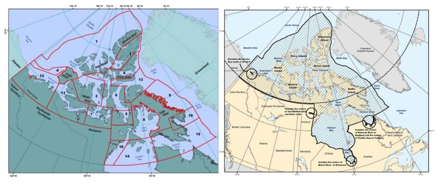
Recommended Citation
Dawson, J., Carter, N.A., van Luijk, N., Cook, A., Weber, M., Orawiec, A., Stewart, E.J., and Holloway, J.E.
(2021). Tourism vessels and low impact shipping corridors in Arctic Canada: trends, risks, community
perspectives, and management strategies. Ottawa: University of Ottawa. DOI: 10.20381/d3dd-yk49.

Acknowledgements
This white paper was researched and written by Jackie Dawson (PhD), Natalie Carter (PhD), Nicolien van
Luijk (PhD), Alison Cook (PhD), Melissa Weber (PhD Candidate), Andrew Orawiec (PhD Candidate), and
Jean Holloway (PhD) of the Environment, Society and Policy Group (www.espg.ca) in the Department of
Geography, Environment and Geomatics at University of Ottawa, Ottawa, Canada and Emma J. Stewart
(PhD) in the Department of Tourism, Sport and Society at Lincoln University, Christchurch, New Zealand.
This white paper is a product of a larger study titled: ‘Arctic Corridors and Northern Voices’ (see
www.arcticcorridors.ca). This white paper was funded by The Pew Charitable Trusts while the larger study
was supported through funding from the Canada Research Chairs Program, ArcticNet, Clear Seas, Fisheries
and Oceans Canada (DFO), Irving Shipbuilding Inc., MEOPAR, Northern Scientific Training Program,
Nunavut Arctic College, Nunavut General Monitoring Program (NGMP), Nunavut Research Institute,
Oceans North, The Pew Charitable Trusts, Students for Canada’s North, the Social Sciences and Humanities
Research Council (SSHRC) of Canada, and WWF-Canada. Support for this research from these
organizations is gratefully acknowledged. The authors recognize the participation of the research
participants, the collaborative efforts made by our community partners, and the contributions of our
community research associates.

The Pew Charitable Trusts is not responsible for errors within this white paper and the opinions reflected
herein do not necessarily reflect that of the organization.

                                                                                                               1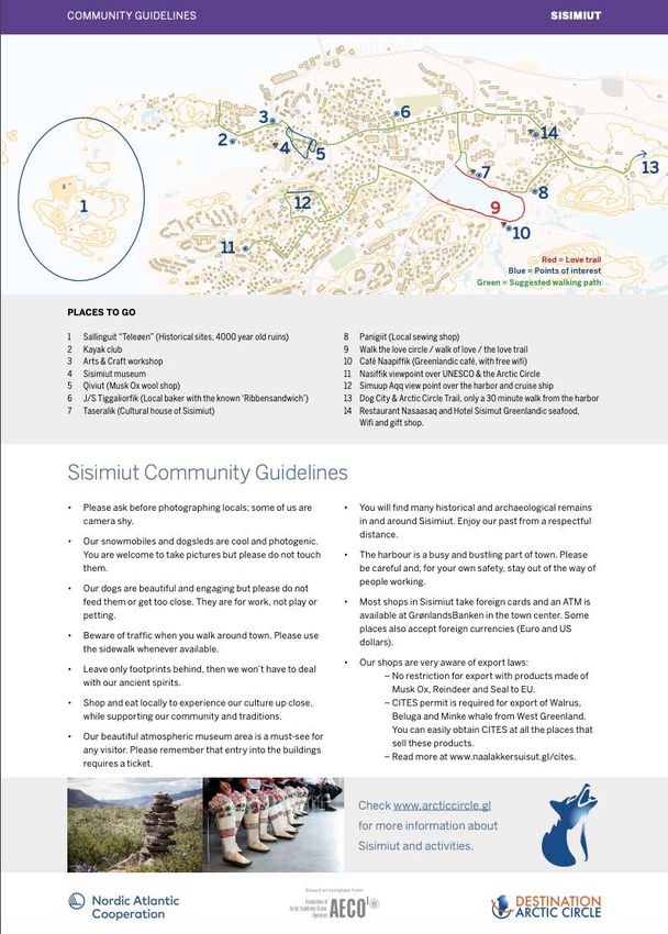
EXECUTIVE SUMMARY

Marine tourism in the Canadian Arctic is a small but rapidly growing industry. Since 1990, the average annual
distance travelled by passenger vessels (e.g., cruise ships) has more than doubled, and for pleasure crafts (e.g.,
commercial or private yachts) the average annual distance travelled has increased by nearly 4000%. This
growth is tremendous, yet, at the same time, pleasure craft vessels are also some of the least regulated vessels
in the Canadian Arctic (Johnston et al., 2017a).

The Federal Government of Canada has responded to the overall need for additional regulatory frameworks
for all vessels in the Canadian Arctic. The government is in the process of developing what is now known as the
Low Impact Shipping Corridors (LISC). The LISC are described as shipping routes throughout the Canadian Arctic
that are intended to provide “infrastructure, navigational support and emergency response services needed
for safer marine navigation, while respecting the environment and local ecology and cultures” (Transport
Canada, 2017a). While this management system has the potential to provide much needed support to many
types of vessels travelling through the Canadian Arctic (e.g. re-supply vessels), this report highlights the need
for the creation of alternative and additional management systems for tourist vessels in particular.

Tourist vessels present unique risks in terms of travel through the Canadian Arctic. The purpose of this type of
travel is not simply to transit through, or to find the safest and fastest route, the purpose is adventure and
exploration. This means that tourist vessels often travel to areas of the Canadian Arctic that are not necessarily
well serviced or charted. The findings of this report show that a significant portion of the distance travelled by
both passenger ships and pleasure crafts occurs outside of the LISC. At the same time, the findings also show
that tourist vessels like to travel through government and community identified areas of significance, such as
Ecologically and Biologically Significant Areas (EBSAs; See Science Advisory Report 2011/055) and
Culturally Significant Marine Areas (CSMAs). The amount that the                     distance travelled increased
through these areas was similar to the overall increase in distance travelled throughout the entire
Northern Canada Vessel Traffic Services (NORDREG) zone (see Canadian Coast Guard, 2021), which
represents the zone of Canadian waters North of 60°, as well as southern Hudson Bay and Ungava Bay, where
vessels must report their daily location and other information to the Canadian Coast Guard. It has also been
found that a number of cruise ship itinerary listings fall within these culturally (CSMA) or environmentally and
biologically (EBSA) significant areas. These findings show that tourist vessels often transit beyond the LISC,
which raises questions about the usefulness of LISC as the single regulatory framework for all vessels.

This report also highlights the concerns of Inuit and northern communities about the effects of tourist vessels
accessing important cultural and/or environmental sites and disrupting subsistence activities in or near their
communities. While tourist vessels have the potential to benefit Arctic communities through supporting the
local economy, the findings show that community members did not always feel that they experienced these
benefits. The report details community-identified recommendations that could be implemented as part of a
broader management system to ensure tourist vessels have minimal negative impacts on communities and
marine wildlife, while at the same time maximizing the positive impacts they could have on these communities.

                                                                                                                2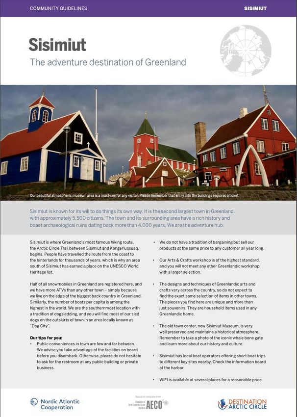
TABLE OF CONTENTS

Executive Summary ................................................................................................................ 2
1.0. Background and Context ................................................................................................. 4
       1.1 Problem Statement ..................................................................................................................................... 4
       1.2 Geographic Focus Areas .............................................................................................................................. 4
       1.3 Defining Arctic Marine Tourism Vessels ...................................................................................................... 5
       1.4. Canadian Arctic Marine Tourism ................................................................................................................. 5
       1.4.1 Low Impact Shipping Corridors ................................................................................................................. 7
       1.4.2 Ecologically and Biologically Significant Areas and Culturally Significant Marine Areas .......................... 9
2.0. Tourism Vessel Traffic in Inuit Nunangat (1990-2018) ....................................................11
       2.1. Temporal and Spatial Trends ..................................................................................................................... 11
       2.2. Tourism Vessel Use of Low Impact Shipping Corridors ............................................................................ 13
       2.3. Tourism vessel use of significant areas..................................................................................................... 15
       2.3.1. Tourism vessel use of Ecologically and Biologically Significant Areas ................................................... 15
       2.3.2. Culturally Significant Marine Areas (CSMA)........................................................................................... 16
       2.3.3 Cruise Ship Itinerary Listings: Advertised Shore-location Visits.............................................................. 18

3.0. Community perspectives on tourism vessels in Inuit nunangat ......................................20
4.0. Management options....................................................................................................23
References.............................................................................................................................26
Appendices ............................................................................................................................30
       Appendix 1. Maritime and Tourism Vessel Regulations .................................................................................... 30
       Appendix 2. Methods ........................................................................................................................................ 42
       Appendix 3. Spatial Tourism Vessel Trends by Year .......................................................................................... 47
       Appendix 4. Tourism Vessel Shore Locations by Region ................................................................................... 49
       Appendix 5. Tourist Code of Conduct for Pond Inlet, Canada ........................................................................... 51
       Appendix 6. AECO Community Guidelines for Pond Inlet, Canada ................................................................... 53
       Appendix 7. AECO Community Guidelines for Sisimiut, Greenland .................................................................. 56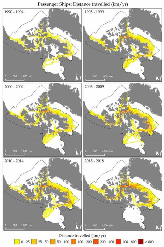
1.0. BACKGROUND AND CONTEXT

1.1   PROBLEM STATEMENT

Low impact shipping corridors (LISC) were designed by the Government of Canada to support safe shipping
and navigation in Arctic Canada. As the region is large and underserviced, a corridors approach is an
effective way to support decision making and investments in infrastructure and marine services. However,
it is unclear if corridors are an effective governance tool for tourism vessels, including cruise ships and
private yachts, which when not in transit tend to travel off the main corridors in search of wildlife and to
engage in shore visits. There may be a need for more diverse governance, as marine tourism vessels and
their passengers have different motivations, transport people versus goods, and exhibit different
behaviors.

In direct response to this problem statement, in this report we provide an analysis of tourism vessel trends
in Arctic Canada since 1990 and an evaluation of the extent that passenger ships (cruise) and pleasure
crafts (yachts) utilized the corridors in this timeframe. To understand impacts and risks from tourism
vessels in Inuit Nunangat, the analysis further examines the extent to which tourism vessels operate in
ecologically and biologically significant areas (EBSAs) and locally identified culturally significant marine
areas (CSMAs) as well as Inuit community perspectives.

1.2   GEOGRAPHIC FOCUS AREAS

The area of focus for this study is the Northern Canada Vessel Traffic Services (NORDREG) zone, which
represents the zone of Canadian waters North of 60°, as well as southern Hudson Bay and Ungava Bay,
where vessels must report their daily location and other information to the Canadian Coast Guard (Figure
1). This zone coincides with Inuit Nunangat, which is an Inuktitut term meaning “Inuit homeland in
Canada” used to describe the four Inuit settled land claims regions: Nunatsiavut (Northern coastal
Labrador), Nunavik (Northern Quebec), the territory of Nunavut, and the Inuvialuit Settlement Region in
the Northwest Territories (Figure 1). The distinct geographic, political and cultural region includes not just
the land but also the water and ice. Inuit Nunangat encompasses roughly 35% of Canada’s landmass and
50% of its coastline (Inuit Tapiriit Kanatami (ITK), 2018). There are 65,000 Inuit in Canada, the majority of
whom live in the 51 communities located in Inuit Nunangat (ITK, 2018). However, the NORDREG zone
notably excludes Nunatsiavut waters (Figure 1). The majority of analysis was conducted exclusively within
the NORDREG zone as it relied on the daily ship location reports that are only provided within this zone.
Additional regions were included in the analysis of shore-locations, as this relied on vessel itineraries
rather than location reports.

                                                                                                            4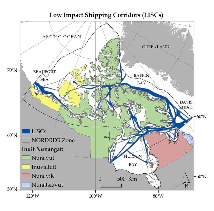
1.3    DEFINING ARCTIC MARINE TOURISM VESSELS

The marine vessels that are the topic of discussion for this white paper are referred to as ‘tourism vessels’,
which includes passenger vessels (cruise ships and expedition cruise ships) and pleasure craft vessels
(commercial yachts and non-commercial yachts). See Table 1 for detailed descriptions.

                                   Table 1: Marine tourism vessel types.

                                             Passenger Vessels

           Cruise Ship
                                  A large passenger ship (200+ passengers)(used for commercial tourism
                                  purposes where the voyage itself and the ship’s onboard amenities, in
                                  addition to destinations (i.e. ports of call), are part of the experience.

      Expedition Cruise Ship
                                  A smaller passenger ship, typically carrying between 50 and 200 paying
                                  visitors, that is used for commercial tourism purposes. They emphasize
                                  adventure, wilderness, education, and personal experiences. These are
                                  the most common type of vessels operating within the global Arctic.

                                           Pleasure Craft Vessels

        Commercial Yacht
                                  A vessel used for commercial purposes. These vessels include private
                                  yachts or motorboats where passenger berths are sold and money or
                                  other form of remuneration for passage on board the vessel occurs.

      Non-Commercial Yacht
                                  A vessel used for recreational purposes only. These vessels include
                                  private yachts and motorboats that are solely being used for pleasure
                                  and where no money or other form of remuneration occurs.

1.4. CANADIAN ARCTIC MARINE TOURISM

Marine tourism is the largest segment of the global Arctic tourism industry in terms of numbers of people,
geographic range, and types of recreational activities (Arctic Council, 2009). It consists of passenger
vessels with commercial or packaged tourists (e.g., cruise ships) that range from expedition (less than 200
passengers) to luxury style and pleasure craft vessels with independent tourists (e.g., sailboats and

                                                                                                            5
yachts). Activity is generally concentrated in the summer months (June-September) when sea ice
conditions are more favorable, the weather is more settled, and there is 24-hour daylight (Orams, 2010).
Compared to other vessels transiting in the Arctic (i.e., re-supply vessels), marine tourism vessels are
unique in the sense that they often do not transit via the most direct route. Instead, they view landscapes
at close ranges, land passengers on shore, seek wildlife and sea ice, and venture into challenging and
sometimes uncharted waters (Dawson et al., 2014).

While the Canadian Arctic represents a small segment of the global Arctic marine tourism industry, it
presents enormous opportunities, risks and challenges for Inuit and Northerners (non-Inuit residents in
Arctic Canada). The Canadian Arctic marine tourism industry emerged in the late 1990s and continues to
attract tourism operators because of its rich culture, history, scenery, natural environment and increased
accessibility (Dawson et al., 2014; 2016; Government of Nunavut, 2016; Johnston et al., 2017b). Many
notable events have influenced and contributed to the development of the marine tourism industry. In
2009, the Government of Canada declared that vessels could traverse the Northwest Passage without
being accompanied by an icebreaker (Bone 2016). In 2014 and 2016 respectively, HMS Erebus and HMS
Terror (from the famous 1845 Franklin expedition) were located; a discovery that generated an enormous
amount of attention. Additionally in 2016, Crystal Serenity became the largest cruise ship to travel through
the Northwest Passage; this ship can carry up to 1070 passengers. It is expected that marine tourism in
the Canadian Arctic will continue to develop because of several factors: greater accessibility, greater
availability of ice-strengthened vessels, demand for remote and authentic tourism experiences, the
landscape and wildlife, and a growing base of retired baby boomers with the means and desire to travel
(Dawson et al., 2010, 2011, 2014; Lemelin et al., 2010, 2012; Johnston et al., 2012).

In the Canadian Arctic marine tourism is managed by a set of international conventions and codes, and
federal and territorial regulations that apply to all vessel types (i.e. cargo, tankers, cruise ships) (see
Dawson et al. 2014). Regulatory regimes for shipping are both complex and constantly evolving and are
further characterized by unique regulatory instruments and multi-jurisdictional challenges. Despite the
complex regulatory environment for maritime shipping in general, non-commercial pleasure crafts,
regardless of size or licensing/ registration status are not subject to the rigorous inspection and
certification regime applicable to commercial craft and larger vessels. In short, non-commercial pleasure
crafts are largely unregulated and fall through the well-entrenched safety nets applicable to international
shipping. Small vessels that are operating as commercial tourism operators are subject to some
regulations but not all.

Please see Appendix 1 for additional information about international, national, and territorial shipping
regulatory frameworks.

                                                                                                          6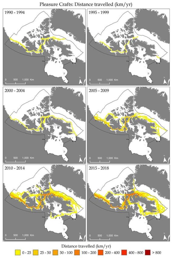
1.4.1   LOW IMPACT SHIPPING CORRIDORS

In response to rapid increases in shipping and expected further increases due to climate change and the
prospect of heightened global maritime trade through the Arctic, the Government of Canada is developing
‘Low Impact Shipping Corridors’ as an adaptation strategy. In a series of announcements in 2016 and 2017,
the Government of Canada stated that they, “will enhance partnerships with Indigenous communities and
Arctic stakeholders to establish Low Impact Shipping Corridors [emphasis Government of Canada]. The
shipping routes established through these initiatives will provide the infrastructure, navigational support
and emergency response services needed for safer marine navigation, while respecting the environment
and local ecology and cultures” (Transport Canada, 2017a).

Ship operators’ use of ‘the corridors’ will be incentivized and voluntary (not mandatory or enforced),
meaning that ship operators may choose to use the corridors because of the infrastructure, navigational
support and emergency response services available within the corridors but they will not be required to
use the corridors. The corridors cover approximately 451,000 km2 out of 3,749,596 km2 of the Canadian
Arctic waters in the Northern Canada Vessel Traffic Services (NORDREG) Zone, which includes Canadian
waters north of 60°, as well as southern Hudson Bay and Ungava Bay (Chénier et al., 2017; Canadian Coast
Guard, 2021).

Preliminary versions of the Low Impact Shipping Corridors, known as Northern Marine Transportation
Corridors (NMTC), were developed based on best available bathymetry, historic shipping traffic
(approximately 80% of vessels traveling in the NORDREG Zone were traveling within the NMTC, and 90%
were traveling within a 5 nautical mile (9.3 kilometre) radius of the corridors at the time of NMTC
inception) (Chénier et al., 2017). Canadian Hydrographic Service paper and digital charts, satellite imagery,
especially in critical depth areas, ice data and avoidance of marine protected areas were main drivers of
NMTC placement (Chénier et al., 2017). Secondary approach corridors, “characterized by medium- to low-
density traffic levels, which can provide access to navigational ports to fulfill supply links and the
movement of passengers” were developed but the primary approach corridors, “The main traffic
highways in the Arctic, [provided] a means to enable secondary access to ports” (Chénier et al., 2017 p.4).
Figure 1 shows a draft map of the Low Impact Shipping Corridors. Note that the corridors are dynamic and
are continually being updated by the Government of Canada.

                                                                                                           7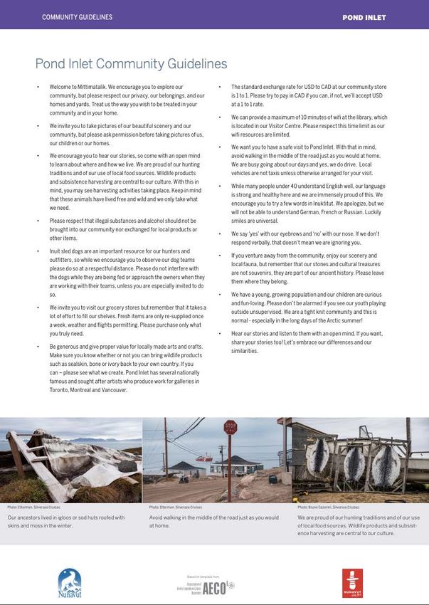
Figure 1: Location of the Low Impact Shipping Corridors (LISCs), the NORDREG Zone, and the four
                                  regions of Inuit Nunangat.

                                                                                                  8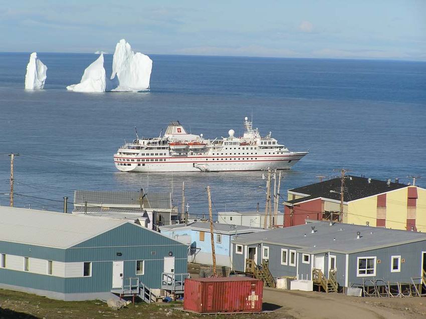
1.4.2 ECOLOGICALLY AND BIOLOGICALLY SIGNIFICANT AREAS AND
CULTURALLY SIGNIFICANT MARINE AREAS

Ecologically and Biologically Significant Areas (EBSAs) and Culturally Significant Marine Areas (CSMAs)
signify areas within the marine environment that are either of ecological, biological, or cultural
importance. EBSAs identified by the Canadian Government are shown in Figure 2. CSMAs identified by
community members who participated in the Arctic Corridors and Northern Voices research project are
shown in Figure 3.

                        Figure 2: Ecologically and Biologically Significant Areas.

Ecologically or Biologically Significant Areas (EBSAs) are areas within Canada’s oceans that have been
identified by the Department of Fisheries and Oceans Canada through formal scientific assessments as
having special biological or ecological significance, when compared with the surrounding marine
ecosystem (See Science Advisory Report 2011/055 for additional information on EBSAs in the Canadian
Arctic). S total of 38 EBSAs have been identified and mapped throughout the Canadian Arctic as shown in
Figure 2. The EBSA data utilized for this report have been sourced from the Open Governmental Data
Portal.

Culturally Significant Marine Areas (CSMAs) are described by Gee et al (2017) as “…places containing one
or several culturally significant features, where one or more communities have a significant connection to

                                                                                                        9
that feature. The term features is used here as shorthand for elements or objects in the landscape (such
as a monument, heritage site, a beach or rock), places or areas (e.g. sacred places or historical sites), or
the activities associated with either of these. Features may also be an ecosystem property (e.g. the
migration of a species), or species themselves.” (143).
10Figure 3: Culturally Significant Marine Areas and communities in Inuit Nunangat.
The data utilized for this report have been sourced from the Arctic Corridors and Northern Voices
Research Project (ACNV). The ACNV project was established in 2014 in direct response to the vital need
to consider local and Inuit knowledge in the low impact corridors across Arctic Canada (see
www.arcticcorridors.ca for more information). The CSMAs identified in Figure 3 represent CSMAs during
the open-water season (~ July to October) as identified by the 14 communities that participated in the
project. CSMAs identified by community members during the non-open water season (November to June)
are not discussed in this report.
Additional information about how these data were sourced is provided in the methods section in
Appendix 2.
2.0. TOURISM VESSEL TRAFFIC IN INUIT NUNANGAT (1990-2018)
2.1. TEMPORAL AND SPATIAL TRENDS
To compare how tourism vessel traffic has changed over time in Inuit Nunangat, the recent past (2010-
2018) was compared to a baseline period (1990-99). Detailed methodology can be found in Appendix 2.
The number of kilometres travelled by both passenger ships and pleasure crafts within the Canadian Arctic
(NORDREG Zone) increased significantly from 1990-99 to 2010-2018. Table 2 shows the kilometres
11travelled by both passenger and pleasure crafts in the NORDREG Zone. The average distance travelled by
passenger ships has more than doubled in 2010-2018 compared to 1990-99. The average distance
travelled by pleasure crafts increased by nearly 4000% in 2010-2018 compared to 1990-99. Figure 4 shows
the spatial trends in the change in average distance travelled for both passenger ships and pleasure crafts
compared to 1990-99 and 2010-18. For passenger ships the greatest increase in distance travelled
occurred mostly through the eastern and central section of the Northwest Passage. For pleasure crafts
the greatest increase in average annual distance travelled occurred throughout the Northwest Passage.
There was a slight decrease in the average annual distance travelled for passenger ships throughout some
sections of the Canadian Arctic, specifically in Hudson Bay. This was likely linked to the closing of the Port
of Churchill in 2016, which is located along the west shore of Hudson Bay in Churchill, Manitoba. Appendix
3 provides additional shipping figures that may be of interest.
Table 2: Distance travelled throughout the Canadian Arctic (NORDREG Zone) in early years (1990-99)
and recent years (2010-18) for passenger ships and pleasure crafts
Sum Sum Distance Distance Difference Factor
Distance Distance travelled travelled in distance increase in
Region and Ship Type travelled travelled per year per year travelled distance
(Km) (Km) (km/yr) (km/yr) per year travelled per
1990-99 2010-2018 1990-99 2010-2018 (km/yr) year
Total NORDREG zone
314,830 611,672 31,483 67,964 36,481 2.2
Passenger Ships
Total NORDREG zone
15,974 570,437 1,597 63,382 61,784 39.7
Pleasure Crafts
Figure 4: Difference in average annual distance travelled (km/yr) between 1990-99 and 2010-18, for
passenger ships (left) and pleasure crafts (right), throughout the NORDREG Zone.
122.2. TOURISM VESSEL USE OF LOW IMPACT SHIPPING CORRIDORS
Table 3 shows the distance travelled by passenger ships and pleasure crafts both inside and outside the
LISC. The LISC were first developed in 2014, then known as the Northern Marine Transportation Corridors
(see Low Impact Shipping Corridors above) and prioritization of the corridors continues today. They have
yet to be introduced for recommended marine use thus any travel within or outside the corridors is
unintentional per se, however, we do point out that the LISC have been developed using similar resources
e.g. bathymetry, ice data etc. that marine vessels would use for navigation, therefore overlap of use is not
unexpected. Figure 5 shows the difference in average annual distance travelled between 1990-99 and
2010-18 by tourist vessels through the LISC. This shows some changes in spatial distribution, for example,
and increase in tourist vessel travel through Inuvialuit Settlement Region and the Northwest Passage
through Nunavut within the proposed LISC.
Approximately half of the distance travelled by both passenger ships and pleasure crafts occurred outside
of the LISC, as shown in Table 4; and approximately half occurred within the LISC 1. Thus, both passenger
ships and pleasure crafts are essentially as likely to be travelling within the LISC as outside of the LISC.
Given the expeditionary nature of tourism vessels and the drivers behind NMTC/LISC placement, it is not
surprising to see that passenger ships and pleasure crafts operators did not confine themselves to the
LISC.
Table 3: Distance travelled inside and outside the LISC for 1990-99 and 2010-18.
Sum Sum Distance Distance Factor
Difference in
Distance Distance travelled travelled increase in
Region and Ship distance
travelled travelled per year per year distance
Type travelled per
(Km) (Km) (km/yr) (km/yr) travelled per
year (km/yr)
1990-99 2010-2018 1990-99 2010-2018 year
Inside LISC
163,412 327,124 16,341 36,347 20,006 2.2
Passenger Ships
Outside LISC
151,418 284,548 15,142 31,616 16,475 2.1
Passenger Ships
Inside LISC
7,494 294,192 749 32,688 31,939 43.6
Pleasure Crafts
Outside LISC
8,480 276,244 848 30,694 29,846 36.2
Pleasure Crafts
1
We note here that the LISC area makes up 627,000km², while the area outside LISC (within the NORDREG zone)
makes up a significantly larger marine area 2,982,170 km².
13Table 4: Distance travelled inside and outside the LISC for 1990-99 and 2010-2018.
Distance travelled Distance travelled
Region and Vessel Type inside and outside LISC inside and outside LISC
1990-99 (%) 2010-18 (%)
Inside LISC
52% 53%
Passenger Ships
Outside LISC
48% 47%
Passenger Ships
Inside LISC
47% 52%
Pleasure Crafts
Outside LISC
53% 48%
Pleasure Crafts
Figure 5: Difference in average annual distance travelled (km/yr) inside Low Impact Shipping Corridors
between 1990-99 and 2010-18, for passenger ships (left) and pleasure crafts (right).
142.3. TOURISM VESSEL USE OF SIGNIFICANT AREAS
In the following section we identify specific areas of potential increased risk throughout the NORDREG
zone that passenger ships and pleasure crafts may travel through. These areas of risk are described as
Ecologically and Biologically Significant Areas (EBSAs) and Culturally Significant Marine Areas (CSMAs).
Section 1.5.2 provides a brief description of these areas. While all vessels could be encouraged to avoid
EBSAs and CSMAs, tourist vessels may specifically seek out these areas to visit as they could include areas
of interest to them (e.g. areas that are home to significant numbers of marine wildlife, or areas of cultural
significance). In this section, we also discuss cruise ship itinerary listings of shore locations as potential
areas of increased risk. These are locations that are identified by cruise ship operators as areas of interest
that might be accessed during the cruise (weather and time permitting). The use of and visitation to
significant areas by tourism vessels can present many risks (e.g. conflict between community members
and tourism vessels; disruption of subsistence hunting activities; impacts to wildlife). While these
locations may not be considered areas of risk in and of themselves, they are of interest as they could
become areas of risk if accessed by cruise ships and tourists.
2.3.1. TOURISM VESSEL USE OF ECOLOGICALLY AND BIOLOGICALLY
SIGNIFICANT AREAS
As described in the methods section in Appendix 2, EBSAs are areas within Canada's oceans that have
been identified through formal scientific assessments as having special biological or ecological significance
when compared to the surrounding marine ecosystem.2 EBSAs make-up just under 60% of the total
NORDREG Zone. Table 5 shows the distance travelled by both passenger ships and pleasure crafts through
EBSAs from 1990-99 and 2010-18. The findings on this table reflect the similar overall trend in increase in
average annual distance travelled by both passenger ships and pleasure crafts from 1990-99 to 2010-18
(see Table 2). Figure 6 shows location of the EBSAs and the difference in average annual distance travelled
through these areas comparing 1990-99 and 2010-18 for both passenger ships and pleasure crafts. As
shown in this figure, there was a significant increase in average annual distance travelled by both
passenger ships and pleasure crafts through some EBSAs, particularly those located along Lancaster
Sound, near Pond Inlet, Nunavut and near King William Island in Kitikmeot Region, Nunavut. There was
also a significant increase in distance travelled by pleasure crafts in EBSAs located in the western coast of
the ISR in the Beaufort Sea. For passenger ships there was also an increase in average annual distance
travelled through EBSAs along the more southerly east coast of Baffin Island.
2
https://dfo-mpo.gc.ca/csas-sccs/Publications/SAR-AS/2011/2011_055-eng.html
15Table 5: Distance travelled inside and outside Ecologically and Biologically Significant Areas (EBSAs) in
1990-99 and 2010-18.
Factor
Sum Distance Distance Difference
increase
Distance Sum Distance travelled travelled in distance
Region and Ship in
travelled travelled (km) per year per year travelled
Type distance
(km) 2010-2018 (km/yr) (km/yr) per year
travelled
1990-99 1990-99 2010-2018 (km/yr)
per year
Inside EBSAs
210,807 380,735 21,081 42,304 21,223 2.0
Passenger Ships
Outside EBSAs
104,036 230,931 10,404 25,659 15,255 2.5
Passenger Ships
Inside EBSAs
8,301 317,781 830 35,309 34,479 42.5
Pleasure Crafts
Outside EBSAs
7,672 252,643 767 28,071 27,304 36.6
(Pleasure Crafts)
Figure 6: Difference in average annual distance travelled (km/yr) between 1990-99 and 2010-18 inside
Ecologically and Biologically Significant Areas (EBSAs) by passenger ships (left) and pleasure crafts
(right).
2.3.2. CULTURALLY SIGNIFICANT MARINE AREAS (CSMA)
The data for Culturally Significant Marine Areas (CSMAs) have come from the results of the Arctic Corridors
and Northern Voices (ACNV) research project led by Dr. Jackie Dawson. The methods section in Appendix
2 describes how CSMAs were identified and documented. These areas represent information documented
in 14 Arctic communities and therefore do not represent all of the potential CSMAs in the Canadian Arctic,
they do however, provide a useful insight into how tourist vessel travel might overlap with areas identified
by communities as being significant to them. These identified CMSAs currently make up 11% of the total
16NORDREG Zone. Table 6 shows the distance travelled by passenger ships and pleasure craft inside and
outside the CSMAs in 1990-99 and 2010-18. The findings in this table reflect the similar overall trend in
increase in average annual distance travelled for both passenger ships and pleasure crafts from 1990-99
to 2010-18 (see Table 2). Similar to the EBSAs, the CSMAs that have experienced the most significant
increases in average annual distance travelled are around Lancaster Sound, Pond Inlet and King William
Island for both passenger ships and pleasure crafts. Figure 7 also shows that there has been a significant
increase in the average annual distance travelled for passenger ships in CSMAs near Iqaluit and for
pleasure craft in CSMAs near the western section of the ISR.
Table 6: Distance travelled inside and outside Culturally Significant Marine Areas (CSMA) in 1990-99
and 2010-18.
Sum Sum Distance Distance Factor
Difference in
Distance Distance travelled travelled increase in
Region and Ship distance
travelled travelled per year per year distance
Type travelled per
(Km) (Km) (km/yr) (km/yr) travelled
year (km/yr)
1990-99 2010-2018 1990-99 2010-2018 per year
Inside CSMA
100,670 190,765 10,067 21,196 11,129 2.1
Passenger Ships
Outside CSMA
214,173 420,900 21,417 46,767 25,349 2.2
Passenger Ships
Inside CSMA
5,407 189,068 541 21,008 20,467 38.9
Pleasure Crafts
Outside CSMA
10,567 381,580 1,057 42,398 41,341 40.1
Pleasure Crafts
Figure 7: Difference in average annual distance travelled (km/yr) between 1990-99 and 2010-18 inside
Culturally Significant Marine Areas (CSMAs) for passenger ships (left) and pleasure crafts (right).
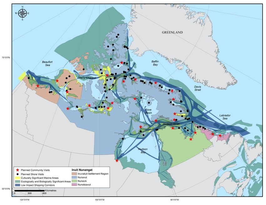
172.3.3 CRUISE SHIP ITINERARY LISTINGS: ADVERTISED SHORE-LOCATION
VISITS
From 2014 through 2019, cruise ship itinerary listings (i.e., advertised daily travel plans) featured 121
unique locations with 1025 planned shore-location visits. Appendix 4 shows these 121 locations divided
into four categories, including 25 communities, 5 historic sites with protected area designation, 19
designated protected areas, and 72 other locations (without protected area designation e.g. fiords,
islands). Data in this section are not limited to the NORDREG Zone as this analysis does not rely on daily
ship location reports; rather it relies on advertised trip itineraries (which are not limited to NORDREG).
Itineraries listed consisted of: one location in each of Manitoba and Yukon Territory, five locations in
Nunavik, six locations in Nunatsiavut, 11 locations in the Inuvialuit Settlement Region, and 97 locations in
Nunavut. Figure 8 shows the locations of the cruise ship itinerary listings from 2014 to 2019. Appendix 2
describes the methods used to identify these itinerary listings.
Figure 8: Number of Advertised Itinerary Listings per Shore Location 2014 to 2019.
Of the 121 shore locations visited by passenger ships since 2014, 79 (65%) had fewer than five planned
visits and 31 locations (24 %) had only one planned visit between 2014 and 2019. These numbers reflect
the infancy of the marine tourism industry in the Canadian Arctic, but they can also be attributed to the
challenging nature of the environment and navigation in the Canadian Arctic. For example, while a
location may have a stunning view, the fiord may not be favorable for navigation or the disembarkation
of passengers may be challenging due to poor visibility, rough seas, rain, wind or the presence of polar
bears, which may result in landing plans being revised or cancelled entirely. The number of locations with
18planned visits ranged from 44 to 75 annually between 2014 and 2019, with the greatest number planned
in 2017. The total number of planned visits on shore ranged from 131 to 192 annually; with the greatest
number planned in 2019.
Figure 9 shows the cruise ship itinerary listings alongside CSMAs, EBSAs, and the LISC. A total of 46 (38%)
cruise ship itinerary listings intersected with CSMAs, 23 (19%) cruise itinerary listings intersected with
EBSAs and only 11 (9%) cruise itinerary listings intersected with LISC. This illustrates that a number of
listings are located within culturally or ecologically and biologically significant areas, while fewer listings
fall within the LISC.3 This demonstrates that passenger vessels are transiting beyond the LISC to reach
cruise itinerary listings.
Figure 9: Culturally significant marine areas, ecologically and biologically significant areas, and the
Low Impact Shipping Corridors overlaid with cruise itinerary listings from 2014 to 2019.
3
It is likely that the overlap between EBSAs and cruise ship itinerary listings would increase significantly
when taking into account that vessels have to travel through an EBSA to reach an itinerary listing that is
located on-land. Tourist vessel travel through EBSAs can be seen in Figure 6.
193.0. COMMUNITY PERSPECTIVES ON TOURISM VESSELS IN INUIT
NUNANGAT
In this section we present some of the findings of the Arctic Corridors and Northern Voices research
project. The ACNV project involved 14 communities in three regions of Inuit Nunangat (Inuvialuit
Settlement Region (6), Nunavut (7) and Nunavik (1)). Note that Nunatsiavut was not covered in the ACNV
project. During workshops held in each of these communities, community members shared their
perspectives about the risks of increased marine vessels traffic and the LISC as a management framework.
This included discussions about tourism vessels such as cruise ships and pleasure craft. These findings are
presented below. See Carter et al., (2019) and Dawson et al., (2020) for detailed information about the
methodological approach of this project.
It is important to note that as a result of the research methods, which involved contributors self-
identifying their community regions, the research does not cover all maritime areas of the federally-
proposed LISC nor of the entire Canadian Arctic region. The recommendations that have emerged are
limited to the areas that communities in this research project utilize, have knowledge about, and wished
to share, and should not be considered regionally comprehensive. See www.arcticcorridors.ca to access
the community reports.
Key concerns about tourism vessels identified by community members included: interference with marine
wildlife and community travel, as well as pollution from tourism vessels; tourists’ (mis)conduct at
important sites and in communities; cultural misunderstandings; insufficient communication with tourism
vessel operators; and lack of tourism benefits to local communities. The tourism-vessel-related concerns
and management recommendations that were identified by our more than 130 project contributors are
presented here (Table 7).
Table 7: Community-identified tourism vessel-related concerns and management recommendations.
Impacts to marine wildlife and environment
Concerns Recommendations
Tourism vessels interfere with marine wildlife - Have local wildlife or environmental monitors
(including migration) and harvesting while transiting onboard passenger ships who could identify areas to
and anchoring in sensitive areas avoid thus helping to protect wildlife.*
- Establish anchoring areas that will not disturb
wildlife or harvesters.
20Icebreaking (to support tourism vessels) negatively - Prohibit all tourism vessel travel outside of the
affects animal migration and community travel and summer months (i.e. transit during open water only)
hunting to maintain safe travel conditions for Inuit, and avoid
disruption of wildlife migration and harvesting (e.g.
caribou).
Tourists lack an understanding of Inuit culture and - Have local cultural hosts onboard passenger ships to
way of life and sometimes invade community educate tourists about the communities, Inuit culture
members’ privacy or judge them (e.g. take unwanted and way of life. This may stimulate tourists to
photos, make judgmental comments based on purchase more local art and crafts.*
assumptions)
Tourists interfere with historic sites and artefacts - Have local cultural hosts onboard passenger ships to
during on-the-land excursions educate, guide, and monitor tourists regarding
respecting the land, leaving it clean and undamaged,
not walking on historic sites, and not removing
artefacts.*
- Limit the number of tourists allowed on land at a
time, to minimize foot traffic impacts on historic and
natural sites, and to make it easier to ensure tourists
follow guidelines.
Tourists visit sites (on land, historic, cultural) outside - Restrict tourists to only visiting communities to
of communities without communities’ knowledge ensure that tourists do not disturb areas outside of
communities without community knowledge and
cultural hosts.
- Require tourism vessels to obtain permission to visit
cultural sites. Some cruise ships already do this; this
provides communities with control over who accesses
the sites and the knowledge of how many people are
visiting.
Pollution from tourism vessels
Concerns Recommendations
Marine vessels dump garbage, grey water and sewage - Consult with vessel operators to make sure there is
which can impact the marine environment and food no dumping of garbage, sewage, grey water during
chain which affects people consuming country (wild) travels.
food
Communication with tourism vessels
Concerns Recommendations
21Tourism vessels impede community members’ ability - Require tourism vessels to register with each
to successfully fish and hunt. community even if only passing through the
community’s (culturally significant) marine use area.
Unknown vessels accessing the community or areas Knowing where and when tourism vessels are
nearby pose safety concerns. transiting will enable community members to mitigate
travel risks and choose alternate harvesting sites and
times.
Not enough notice is given by passenger ships for - Passenger ships should provide adequate notice of
communities to prepare for tourists. their estimated arrival date to enable communities to
prepare crafts and cultural performances.*
Pleasure crafts travel through the Canadian Arctic - Increase Royal Canadian Mounted Police (RCMP) and
unannounced and do not have to notify anyone of Canada Border Services Agency (CBSA) presence.
their presence. They arrive in communities without RCMP and CBSA should assist communities when
notice and some engage in illegal and (or) dangerous unannounced pleasure crafts arrive and/or if security
behaviour which poses a risk to local safety. concerns arise.
Ensuring that tourism benefits local communities
Concerns Recommendations
Communities do not reap potential economic benefits - Enable increased numbers of community members
from cruise ship tourists. Passenger ship tourists do to benefit from the economic opportunities (i.e. craft
not spend (much) money in communities. sales) that passenger ship tourists present through
publicly-funded 1) training for artisans and crafters,
and 2) infrastructure for cultural centres to attract
investments and to support tourism.*
- Employ community members as guides, drivers,
crafters, and performers on passenger ships and
during excursions.*
- Encourage tourists to disembark and spend money in
the town versus staying on the ship. *
*Source of income/economic benefit to community members.
224.0. MANAGEMENT OPTIONS
In this white paper, our findings have shown that the distance travelled by tourist vessels in the Canadian
Arctic in the past 10 years is significantly greater than thirty years ago. We have also shown that passenger
ships and pleasure crafts travel near equally within and outside LISC and travel extensively through EBSAs
and CMSAs. Indeed, the very features that lead to CSMAs and EBSAs being designated as such, carry great
appeal for passengers onboard passenger ships and pleasure crafts. Thus, while the LISC can support safer
travel, infrastructure and prioritization, for 50% of the distance tourism vessels travel it is evident that
enhanced management systems for passenger ships and pleasure craft are needed to mitigate risks when
travelling outside of the LISC and within CSMAs and EBSAs. Moreover, local (Inuit) community
perspectives must be considered in the development of those management systems through co-
governance and other approaches, as must domestic and international codes and legislation.
Through our analysis we identified potential management options that could be implemented in addition
to, or alongside, the LISC framework to create a more robust management approach that caters to tourism
vessels travelling beyond the LISC and into areas designated as ‘increased risk’ such as EBSAs and CSMAs.
The management options provided in Table 8 are based on the findings of this report, including the tourist
vessel data and the community-based data. In addition, we have a drawn on successful existing regulatory
approaches that have been implemented in Canada and internationally.
Table 8: Management options for tourism vessels travelling in Inuit Nunangat.
Management Options
Develop site specific guidelines for highly visited significant, sensitive shore locations
Site guidelines are codes of conduct for specific locations or areas which simultaneously allow for the possibility
of great nature experiences while safeguarding the environment and cultural remains. Site guidelines that are
already in place in Antarctica and Svalbard are a voluntary management mechanism, which have been highly
effective in reducing impacts on sensitive shore sites across the Polar Regions. Shore locations that are highly
visited and that are sensitive would benefit from site-specific guidelines to help ensure that visitors carefully
conserve the natural and cultural heritage of the sites. Site guidelines are often used in Polar Regions in order to
drive traffic to certain pre-selected sites/shore locations so that traffic can be managed. By default, sites that do
not have established site guidelines are ‘preserved’ because they are not advertised.
Highly visited and (or) significant sites across Inuit Nunangat, such as those presented in this report, should be
identified and a series of site guidelines developed. The guidelines should include both interpretative/educational
information as well as instructions for behavior and use and be integrated with any existing guidelines, for
example, at protected sites. Existing guidelines from Antarctica and Svalbard can be used as a template and
adapted for Inuit Nunangat. A booklet of site guidelines should be made available electronically through a range
of sources (e.g., Regional Tourism Agencies, Territorial and Provincial Governments, and AECO websites) with hard
copies available for purchase.
23Develop community-visit codes of conduct (guidelines) to complement the site-specific guidelines
Codes of conduct should be developed by communities in collaboration with relevant stakeholders (e.g.
government and operators) and once established should be reviewed annually in collaboration with communities.
Existing guidelines from Pond Inlet, Nunavut (Appendix 5) and Sisimiut, Greenland (Appendix 6) and the Cruise
Handbook for Svalbard (Norwegian Polar Institute 2015) should be adapted to a regional scale and distributed as
needed for use in Inuit Nunangat communities and on passenger ships and pleasure crafts. Codes of conduct
should reflect local priorities (e.g., guided-tour requirement, use of public washroom facilities, bargaining,
interacting with dogs, photography and privacy preferences, export laws, traffic, and safety) and include maps
and information about sites and attractions that visitors are welcomed to explore.
Enhance local monitoring programs to include ship observations
Monitoring programs are becoming very common across the Arctic and are generally used to observe wildlife
patterns and environmental changes. The increasing number of vessels operating in Canadian Arctic waters and
the vast geography of the region makes monitoring and enforcement for non-compliance among vessels very
difficult. Informal and formal programs can be established whereby harvesters and other marine users can
participate in ship monitoring and reporting. The Nunavut Tunngavik Incorporated (NTI) led Inuit Marine
Monitoring Program Pilot Project could serve as a model for expansion to interested communities across Inuit
Nunangat (NTI 2017).
Develop and adapt additional codes of conduct for use in Inuit Nunangat (e.g. travel outside of
communities)
Shore locations (e.g. historic sites, protected areas, fiords) also require attention. If it is not possible to legally
require operators to have paid Inuit guides/interpreters on board vessels operating in Inuit Nunangat, then this
should be included in a code of conduct and highly encouraged as a voluntary measure. There are some examples,
such as the AECO code of visitor conduct for Arctic regions or the World Wildlife Fund (WWF) codes of conduct
for tourists and operators. It is also recommended that a series of wildlife viewing guidelines be established for
the specific context of Inuit Nunangat.
Implement co-governance approaches involving Inuit
With the Government of Canada’s revitalized commitments to renewing nation-to-nation, Inuit-to-Crown
relationships, and upholding Indigenous legal traditions, there exists a unique opportunity to create innovative
co-governance arrangements. Such arrangements must recognize the inherent jurisdiction of Inuit over coastal
and ocean areas, and that Inuit and colonial governments jointly share decision-making authority through
collective decision-making. Co-governance implementation will necessitate greater collaboration between
federal, provincial, territorial and Inuit governments, and must take into account the livelihood, health and well-
being of communities who depend on the ocean for their livelihood and way of life. Co-governed areas in Arctic
marine areas such as Tallurutiup Imanga National Marine Conservation Area, and avenues being explored to
establish a Canadian-Greenlandic management regime for Pikialasorsuaq (the North Water polynya) that is Inuit
led can serve as a framework for developing these approaches (Inuit Circumpolar Council N.D).
Implement community-identified tourism vessel-related management recommendations
24The recommendations made by community members related to tourism-vessel management in section 3.0.
demonstrate ways in which Inuit knowledge can be incorporated and Inuit themselves can be involved in more
meaningful ways. Not only will implementation of these recommendations ensure that tourism vessels are
managed in effective, culturally appropriate ways and will potentially become a global example of respectful,
sustainable tourism-vessel management in the global Arctic., they will also create and much-needed income and
employment opportunities for Inuit.
Enhance tourism vessel tracking systems
Promote and support mechanisms to make Automatic Identification System (AIS) mandatory for all vessels,
regardless of vessel size throughout Arctic Canada.
Adapt the Pew Charitable Trusts’ 2016 integrated Arctic corridors framework as a foundation for
tourism vessel management
In accordance with recommendations outlined above, develop a governance system for marine tourism that
integrates human and vessel safety, Inuit rights, and environmental protection in order to provide Canada with a
balanced and adaptable structure for managing tourism vessels (The Pew Charitable Trusts 2016). This co-
governance system must be guided by three principles: 1) Develop and adhere to world-leading standards for
human and vessel safety in Arctic waters; 2) Establish comprehensive protection for the Arctic marine
environment and its wildlife; and 3) Fully and formally include Inuit in Arctic shipping policy creation and
implementation. Additionally it will be important to 1) consult and meaningfully engage Inuit leadership and
communities; 2) integrate information including shipping and ice data, wildlife migration routes, and human use,
including Inuit traditional knowledge; 3) designate guidelines and policies that meet appropriate environmental
standards for commercial shipping in ecologically and biologically sensitive areas; and 4) classify tourism-vessel
management according to risk to ensure targeted investment in infrastructure and services and management of
high-risk areas.
25REFERENCES
Arctic Council. (2009). Arctic marine shipping assessment (AMSA). Retrieved from
https://www.pame.is/projects/arctic-marine-shipping/amsa.
Association of Arctic Expedition Cruise Operators. (2020). AECO. Retrieved from
https://www.aeco.no/about-aeco/.
Bone, R.M. (2016). The Canadian North: Issues and Challenges. UK: Oxford University Press.
Carter, N.A., Dawson, J., Simonee, N., Tagalik, S., & Ljubicic, G. (2019). Lessons Learned through
Research Partnership and Capacity Enhancement in Inuit Nunangat. Arctic, 72 (4). 381-403.
https://doi.org/10.14430/arctic69507.
Canadian Coast Guard (CCG, 2013). Vessel traffic reporting Arctic Canada traffic zone (NORDREG).
Retrieved from: http://www.ccg-gcc.gc.ca/eng/MCTS/Vtr_Arctic_Canada
Chénier, R., Abado, L., Sabourin, O., & Tardif, L., 2017. Northern marine transportation
corridors: creation and analysis of northern marine traffic routes in Canadian waters.
Trans. Gis 21 (6), 1085–1097.
Dawson, J., Carter, N.A., van Luijk, N., Weber, M., & Cook, A. (2020). Community-based mapping
methods for documenting Arctic community perspectives about shipping impacts and low-impact
corridors. MethodsX. 7,101064. https://doi.org/10.1016/j.mex.2020.101064.
Dawson, J., Stewart, E.J., Johnston, M.E., et al. (2016). Identifying and evaluating adaptation
strategies for cruise tourism in Arctic Canada. J. Sustain. Tour. 24 (10),
1425–1441. https://doi.org/10.1080/09669582.2015.1125358.
Dawson, J., Johnston, M.E., & Stewart, E.J. (2014). Governance of Arctic expedition cruise
ships in a time of rapid environmental and economic change. Ocean Coast. Manag.
89, 88–99. https://doi.org/10.1016/j.ocecoaman.2013.12.005.
Dawson, J., Johnston, M. E., Stewart, E.J., Lemieux, C.J, Lemelin, R.H., Maher, P.T. & Grimwood, B.
(2011). Ethical considerations of last chance tourism. Journal of Ecotourism 10(3): 205-262.
DOI:10.1080/14724049.2011.617449
Dawson, J., Stewart, E.J., Lemelin, H. & Scott, D. (2010). The carbon cost of polar bear viewing in
Churchill, Canada. Journal of Sustainable Tourism 18(3): 319-336. DOI:10.1080/09669580903215147.
Fisheries and Oceans Canada. (2019). Tarium Niryutait Marine Protected Area (TN MPA). Retrieved from
https://www.dfo-mpo.gc.ca/oceans/mpa-zpm/tarium-niryutait/index-eng.html
Gee, K., Kannen, A., Adlam, R., et al. (2017). Identifying culturally significant areas for marine spatial
planning. Ocean & coastal management, 136, 139-147.
26Government of Canada. (2012). Arctic Waters Pollution Prevention Act (AWPPA). Retrieved from
https://tc.canada.ca/en/marine-transportation/arctic-shipping/arctic-waters-pollution-prevention-act-
awppa.
Government of Canada. (2013a). Marine Liability Act: 2001 C6. Retrieved from
https://tc.canada.ca/en/corporate-services/acts-regulations/marine-liability-act-2001-c-6.
Government of Canada. (2013b). Maritime Transportation Security Act (MTSA). Retrieved from
http://www.tc.gc.ca/eng/marinesafety/debs-arctic-acts-regulations-mtsa-1166.htm
Government of Canada. (2013c). Navigable Waters Protection Act (NWPA). Retrieved from
http://www.tc.gc.ca/eng/marinesafety/debs-arctic-acts-regulations-nwpa-
1308.htm.
Government of Canada. (2013d). Coasting Trade Act. Retrieved https://tc.canada.ca/en/corporate-
services/policies/coasting-trade-canada.
Government of Canada. (2016). About the Species at Risk Act. Retrieved from
https://www.canada.ca/en/environment-climate-change/services/environmental-enforcement/acts-
regulations/about-species-at-risk-act.html.
Government of Canada. (2017a). Canada’s Oceans Strategy. Retrieved from https://waves-vagues.dfo-
mpo.gc.ca/Library/264675.pdf.
Government of Canada. (2017b). Canada Shipping Act (CSA) 2001. Retrieved from
https://tc.canada.ca/en/marine-transportation/arctic-shipping/canada-shipping-act-csa-2001.
Government of Canada. (2019). Canadian Environmental Protection Act, 1999 and related documents.
Retrieved from https://www.canada.ca/en/environment-climate-change/services/canadian-
environmental-protection-act-registry/related-documents.html.
Government of Canada. (2020). Oceans Protection Plan. Retrieved from
https://tc.canada.ca/en/initiatives/oceans-protection-plan.
Government of Nunavut. (2016a). Nunavut Marine Tourism Management Plan 2016-2019: Communities
prepared for and benefitting from marine tourism.
International Maritime Organization. (2019a). International Convention on Maritime Search and Rescue
(SAR). Retrieved from https://www.imo.org/en/About/Conventions/Pages/International-Convention-on-
Maritime-Search-and-Rescue-(SAR).aspx.
International Maritime Organization. (2019b). International Convention on Oil Pollution Preparedness,
Response and Co-operation (OPRC). Retrieved from
https://www.imo.org/en/About/Conventions/Pages/International-Convention-on-Oil-Pollution-
Preparedness,-Response-and-Co-operation-(OPRC).aspx.
27You can also read