A Beast in the Field: The Google Maps Mashup as GIS/2
←
→
Page content transcription
If your browser does not render page correctly, please read the page content below
A Beast in the Field: The Google Maps
                               Mashup as GIS/2

                                                       Christopher C. Miller
                   Sue ft Radcliffc Killam Library / Texas Aft/W Internotionol   University / Laredo / JX / USA

                                                 ••'    .•   Abstract

Over the last decade or more, geographic information systems (GIS) have proved themselves nimble and potent tools in
myriad academic, civic, and political disciplines. A body of scholarship followed GIS on its rise to wider acceptance and
adoption, however, that questioned its nature and the way its power was wielded. This scholarship ultimately produced
various models for "GIS/2," an amalgam of GlS's power and the grassroots democratic activity that might have been
fostered by it but largely was not. This article revisits going models of GIS/2 and finds them to be so much vapourware
compared to recent developments in online geospatial applications. The article argues that for all of the weil-intentioned
effort put into GIS/2 theory, the most progressive real-world candidate for GIS/2 has been produced only recently, by
another rare combination indeed: two Austin, Texas, 20-somethings and the online search monolith Google.
   The Google Maps mashup, a very twenty-first-century beast born of code from disparate Web applications, exhibits
great potential to be a real live GIS/2. Moreover, there Is one mashup in particular that, while perhaps not quite mature
enough to realistically match 15yearsof GIS/2 scholarship, is still possibly the finest working exampleyet of the ideas and
concepts posited therein.

Keywords: geographic information systems (GIS), GIS/2, public participation GIS (PPGIS), Hurricane Katrina, Google Maps, mashups,
Scipionus

                 , r-
                                                             Resume

Depuis dix ans ou plus, les systemes d'information geographique (GIS) se sont reveles des outils puissants et tres efficaces
dans une myriade de disciplines universitaires, civiques, et politiques. Les tenants de ces disciplines ont de plus en plus
accepte et adopte le GIS, en remettant toutefois en question sa nature et la fa^on d'utillser ses attributs. Cette mission
professorale a en fin de compte produit divers modeles pour « GIS/2 », un amalgame de la puissance du GIS et de I'activite
democratlque populaire qui aurait pu en decouler mais qui ne s'est pas beaucoup manifestee. Le present article presente
une nouvelle analyse des modeles actuels de GIS/2 et en deduit qu'ils semblent tres ephemeres comparativement aux
recents developpements dans le domaine des applications geospatiales en ligne. L'article fait valoir que, pour tous les
efforts bien intentionnes consacres a la theorie du GIS/2, le candidat le plus progressif en situation reelle pour le GIS/2 n'a
ete produit que recemment, grace a une autre combinaison des plus rare, soit deux personnes dans la vingtaine d'Austin
(Texas) et Google, le monolithe de la recherche en ligne.
   L'application composite (ou mashup] des cartes Google Maps, un animal tres vingt et unieme siecle qui combine du
contenu provenant de plusieurs sites Web, offre un enorme potentiel de transformation en un vrai de vrai GlS/2. En outre,
une application composite existante, bien qu'elle ne soit pas assez a point pour offrir de fa^on realiste autant que les
15 annees d'experience du GIS/2, est peut-etre le meilleur exemple pratique jusqu'a maintenant des idees et des concepts
qui y sont proposes.

Mots-cles : systemes d'information geographique (GIS), GIS/2, information geographique et participation publique (PPGIS), ouragan
Katrina, Google Maps, mashup, Scipionus

cartographica (volume 41, issue 3)                                                                                           187
Christopher C. Miller

                        1 Introduction                           whom access to authoritative, quality data was also not a
                                                                 problem; and, more controversially, those for whom the
There seems to be no dearth of chatter lately about just         factual relationship with geospace was more important
what information sub-industry Google will kill off first.        than the social or political relationship. Left out of this
Some say other search engines will die, some say online          new movement, then, were those without support for
classifieds; some say libraries are already in the throes of a   machinery and infrastructure and training and also those
grim demise, and still others - the more optimistic of the       for whom GIS needed to be a social, communal, and local
lot - say that Microsoft's lumbering, bloated empire will        collaboration tool more than a hard scientific instrument.
be slain. Something about registering over $9.4 billion in
                                                                 Suffice it to say that, not long at all after GIS became
assets and over $1.5 billion in revenue, and investing in
                                                                 generally available, organizations and individuals with an
partnerships and initiatives that nearly span the gamut of
                                                                 interest in public policy and community development
all good technological society, will tend to warrant such
                                                                 found themselves, as Nancy Obermeyer puts it, "poorly
interest, I suppose.' There is a much sm;Uler industry,
                                                                 represented in today's GIS" (1998, 65). So great was the
however, for which at least a few developers at Google
                                                                 promise of GIS, and so conspicuous the political,
have a glad eye and which may actually benefit from the
attention paid to it by this company: online mapping,            economic, and cultural gap between those for whom the
geospatial query, and GIS. I am arguing here that Google's       promise was being fialfilled and those for whom it was
Google Maps service, or, more, specifically the applica-         not, that attempts were soon made to examine GIS with
tions being built atop its easily hackable application           new critical tools, as a socio-political issue.
programming interface (API), are poised to provide that          These attempts were developed as theory in the pages of
very rare beast about which GIS scholars have been               Cartographica, Cartography and Geographic Information
arguing for some time: a geospatial information platform         Systems, URISA Journal, and other like-minded publica-
upon which non-GIScientists, but nonetheless interested          tions, which have hosted an open discussion, over the
parties, can read, write, alter, store, test, represent, and     course of the last decade, that has addressed w^at is
present information in ways that they desire and in              fimdamentally and nominally inclusive or exclusive,
formats and environments they understand. Theoretical,           empowering or exhausting, democratic or technocratic,
nearly philosophical models have existed for many years          about GIS. This dialogue, generally known as the "GIS
that attempt to describe, and by describing, engender            and Society" debate, began in earnest during and
a public infiltration of GIS as GIS has come to be:              following the Initiative 19: GIS and Society (1-19)
exclusionary, expensive, increasingly technocratic. This         workshop in March 1996 and the National Research
article posits, with caveats, that of all companies, agencies,   Council summit in April 1996, though Trevor Harris and
or individuals that could have built a prototype GIS             Daniel Weiner (1998) suggest that the origins of the
platform able to support grassroots activism and public          discourse trace back to the late 1980s. Regardless of the
participation in ways discussed throughout the "GIS and          true origins of the discussion, the issues most directly
Society" debate over the last decade or more, it i.s the         addressed during the GIS and Society debate certainly
gargantuan, commercial Google, Inc., that has done it.           grew in coincidence with the general availability of GIS as
                                                                 a technology, method, or tool (its true nature is debated
                                                                 still) through much of the 1990s to today.
               2 The GIS and Society Debate

The advance of the desktop computer in the 1980s and                                      3 GIS/2
the networked desktop in the 1990s brought geographic
information systems to public- and private-sector agen-          In the Initiative 19 workshop and the discussion that
cies whose missions proved fecund territory for the kinds        followed, alternative perspectives were trained on GIS
of analysis, presentation, representation, and information       and its potential to persuade, improve communication,
organization at which GIS is especially adept, and,              support collaboration, and use the Internet as a publish-
therefore, in whom the excitement over the supposed              ing machine in order to delineate what were coming to be
agility and latent potential of GIS was palpable. The power      seen as negative, exclusionary outcomes of GIS (NRC
of GIS to analyse and illustrate, trapped in a bottle and set    1997, 24). The issues that distinguished themselves within
on the desktop, suggested that public access to planning         this body of scholarship varied, and vary still, but
processes and research of many types would be greatly            generally hover around the user empowerment, grassroots
enhanced - that the technology might even arouse greater         power, marginalization, and technocracy that did or did
participation in the democratic process.^                        not result from the widespread adoption and application
This assumption about GIS has proved only partly true,           of GIS. Critics of monolithic GIS proper began reinvent-
or, perhaps more accurately, has become true for only the        ing, redefining, even rebuilding it so that a new subset
portion of that user population that could muster support        could be given over to those individuals, organizations,
for hardware, software, data, and training; those for            communities, and agencies who were finding themselves

188                                                                                   cartographica (volume 41, Issue 3)
A Bea5t in the Field: The Google Maps Mashup as GIS/2

outgunned and overmatched by their governments and                outright, as have Paul Schroeder (1996), Marc Schlossberg
private-sector counterparts, who were acquiring the               and aiiot Shuford (2005), Harris and Weiner (1998).
technologies and training to allow them to both use               Obermeyer (1998), Emily Talen (2000). and Renee Sieber
GIS and steer its development. Born of this attention,            (2003, 2004). As difficult as it is for GIS to accommodate
discussion, and critique was GIS/2, a proposed alternative        non-Euclidean, demotic, vernacular representations of
to mainstream GIS that would account for the less rigid,          space and information, it seems more difficult still for
more socially and culturally mutable information needs            GIS/2 wTiters to fully and concretely imagine a system that
of user groups being shut out by GIS/1. GIS/2 was an              would. The result is that definitions in print of GlS/2 seem
attempt at developing - imagining, at least - a more              disproportionate to the specific real-world GIS projects
equitable, accessible, and empowering GIS, and the                that can even come close to matching these descriptions.
attempt is playing out to this day in matrices                    Sieber's (2004) recent call to rewire for a GIS/2, for
and models and definitions scattered about the pages of           example, illustrates simultaneously the sound philosophy
the germane literature that all attempt to bring                  and scattered practicality of GIS/2. As she traces a brief
the notoriously nebulous and contradictory idea of                history of GIS/2, then outlines four different approaches
accessible-but-powerful,    technological-but-democratic,         to its rewiring, then provides examples of systems rewired
professional-but-affordable GIS into some focus.                  as such, one gets the impression that the collective work
Unfortunately, nebulousness and contradiction make for            done on GIS/2 is top heavy; that, for all of our
a difficult coding experience. That is, the software and          intellectualizing, deconstructing, and gerrymandering,
hardware heart of modern GIS does not easily bleed                there seem to be remarkably few good instantiations of
for those kinds of geographic information that are                GlS/2 to which we can point and say "that is a GIS that
incomputable by GIS alone, that come from or are                  empowers, allows and accommodates public input, aids
dependent upon vernacular or cultural or otherwise non-           and abets the process of civic action, and fulfils the
veridical information. Harris and Weiner find plenty of           promise of GIS to augment democratic participation."
space for both:                                                   Sieber's examples of systems with new insides range fi"om
                                                                  the startlingly simple (macros) to the unrealistically
  Certainly, the social history of GIS development places the
                                                                  complex (build your own spatial decision support
  technology within a westem. first world science paradigm.
                                                                  system). In between are methods that exist already
  The system is predominantly based upon the scientific
                                                                  (draw and model traditional knowledge atop or beside
  map as metaphor and the basic spatial primitives of point,
                                                                  modern, authorized data sets); are a little too far-fetched
  line, polygon, and pixel But what of qualitative forms of
                                                                  to be solutions (get a job at ESRl); or hardly seem to
  knowledge? Non-Euclidean sketch maps, cognitive and
                                                                  warrant a body of scholarship at all (allow input from
  mental maps, nan-ative and oral histories, pictorial images
                                                                  Post-It notes, create text input forms) (2004, 32-33).
  and moving images are generally excluded from current GIS
                                                                  Solutions that respond to .specific, local needs of users
  knowledge bases. Such "alternative" forms of knowledge
                                                                  (bird's-eye viewers, input forms, etc.) notwithstanding,
  representation and understanding are crucial to under-
                                                                  Sieber's true-life examples of rebuilt and rewired GIS
  standing issues related to place, a premise claimed by
                                                                  don't seem to have been rebuilt or rewired so much as
  GIS. GIS epistemologies and multiple realities thus pose
                                                                  patched. Sieber, of course, is aware of this. 'The
  considerable challenges to Ihc GIS community with regard
                                                                  approaches described above present opportunities to
  to handling potentially confliclincj information arising
                                                                  expand GIS," she writes; "creating a GIS/2 has consisted
  from broadening the representation of groups within the
                                                                  of working with the technology 'as is' and fixing any gaps.
  system and combining top-down expert knowledge with
                                                                  Rebuilding GIS takes a systems-des ign approach and
  bottom-up local knowledge. (Harris and Weiner 1998, 70;
                                                                  utilizes current trends in computing science" (2004, 33;
  Rundstrom 1995).
                                                                  emphasis added). Sieber moves on to describe some of
   Harris and Weiner are neither the first nor the last to        these current trends and even goes so far as to sketch a
equate GIS with the imperial mapping exercises of some            forward-thinking model for GIS that modularizes the
Westem agencies that can perhaps go unnamed. Nor are              components of GIS in order to expedite the integration of
they the first GIS scholars to indirectly identify one central    "different ways of knowing" (2004, 33).
conflict - a dirty secret, even - of the GIS/2 .story: that the   Sieber has her finger on the pulse of what appears to be
kind of GIS for which many scholars are pining is such a          the future of our Web and desktop systems: geo-enabled
rare bird that it has yet even to be adequately described.        (not strictly geographic) data and XML. What is
The foundational act of defining GIS/2 and, having                important here, though, is that Sieber's ultimate rewiring
defined it, describing real-life examples of its application      model is just that: a model. There is no tangible example
has proved jast as vexing for GIS/2 scholars as it certainly      of this GIS/2, save for an XML-tagging exercise that
would have been to any early developer of GIS/1 struck by         illustrates how writeable, taggable XML fits within a
the same fancy. John Pickles (1995) has wrestled with it          much greater, more abstract information topology

cartographica (volume 41, issue 3)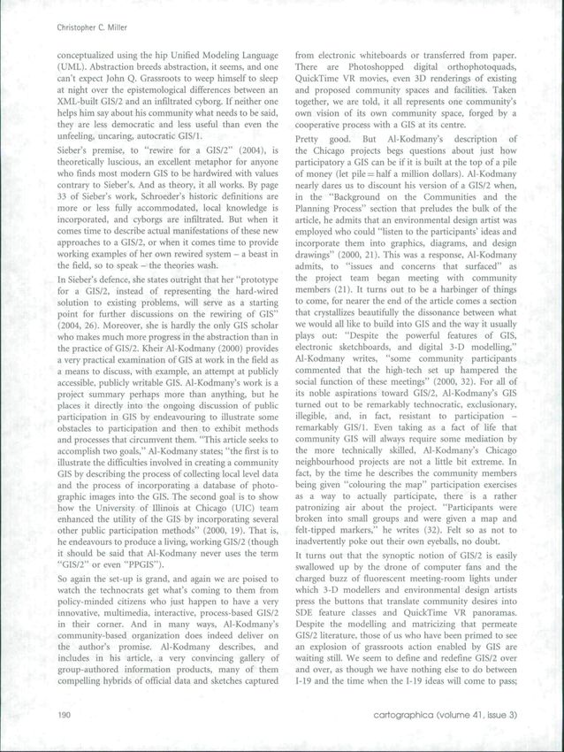
Christopher C. Miller

conceptualized using the hip Unified Modeling Language         from electronic whiteboards or transferred from paper.
(UML). Abstraction breeds abstraction, it seems, and one       There are Photoshopped digital orthophotoquads,
can't expect John Q. Grassroots to weep himself to sleep       QuickTime VR movies, even 3D renderings of existing
at night over the epistemotogical differences between an       and proposed community spaces and facilities. Taken
XML-built GIS/2 and an infiltrated cyborg. If neither one      together, we are told, it ali represents one community's
helps him say about his community what needs to be said,       own vision of its own community space, forged by a
they are less democratic and less useful than even the         cooperative process with a GIS at its centre.
unfeeling, uncaring, autocratic GIS/1.                         Pretty good. But Al-Kodmany's description of
Sieber's premise, to "rewire for a GIS/2" (2004), is           the Ghicago projects begs questions about just how
theoretically luscious, an excellent metaphor for anyone       participatory a GIS can be if it is built at the top of a pile
who finds most modem GIS to be hardwired with values           of money (let pile —half a million dollars). Al-Kodmany
contrary to Sieber's. And as theory, it all works. By page     nearly dares us to discount his version of a GIS/2 when,
33 of Sieber's work, Schroeder's historic definitions are      in the "Background on the Communities and the
more or less fully accommodated, local knowledge is            Planning Process" section that preludes the bulk of the
incorporated, and cyborgs are infiltrated. But when it         article, he admits that an environmental de.sign artist was
comes time to describe actual manifestations of these new      employed who could "listen to the participants' ideas and
approaches to a GIS/2, or when it comes time to provide        incorporate them into graphics, diagrams, and design
working examples of her own rewired system - a beast in        drawings" (2000, 21). This was a response, Al-Kodmany
the field, so to speak - the theories wash.                    admits, to "issues and concerns that surfaced" as
                                                               the project team began meeting with community
In Sieber's defence, she states outright that her "prototype
                                                               members (21). It turns out to be a harbinger of things
for a GlS/2, instead of representing the hard-wired
                                                               to come, for nearer the end of the article comes a section
solution to existing problems, will serve as a starting
                                                               that crystallizes beautifully the dissonance between what
point for further discussions on the rewiring of GIS"
                                                               we would all like to build into GIS and the way it usually
(2004, 26). Moreover, she is hardly the only GIS scholar
                                                               plays out: "Despite the powerful features of GIS,
who makes much more progress in the abstraction than in
                                                               electronic sketchboards, and digital 3-D modelling,"
the practice of GIS/2. Kheir Al-Kodmany (2000) provides
                                                               Al-Kodmany writes, "some community participants
a very practical examination of GIS at work in the field as
                                                               commented that the high-tech set up hampered the
a means to discuss, with example, an attempt at publicly
                                                               social function of these meetings" (2000, 32). For all of
accessible, publicly writable GIS. Al-Kodmany's work is a
                                                               its noble aspirations toward GIS/2, Al-Kodmany's GIS
project summary perhaps more than anything, but he
                                                               turned out to be remarkably technocratic, exclusionary,
places it directly into the ongoing discussion of public
                                                               illegible, and, in fact, resistant to participation -
participation in GIS by endeavouring to illustrate some
                                                               remarkably GIS/1. Even taking as a fact of life that
obstacles to participation and then to exhibit methods
                                                               community GIS will always require some mediation by
and processes that circumvent them. "This article seeks to
                                                               the more technically skilled, Al-Kodmany's Chicago
accomplish two goals," Al-Kodmany states; "the first is to
                                                               neighbourhood projects are not a little bit extreme. In
illustrate the difficulties involved in creating a community
                                                               fact, by the time he describes the community members
GIS by describing the process of collecting local level data
                                                               being given "colouring the map" participation exercises
and the process of incorporating a database of photo-
                                                               as a way to actually participate, there is a rather
graphic images into the GIS. The second goal is to show
                                                               patronizing air about the project. "Participants were
how the University of Illinois at Chicago (UIC) team
                                                               broken into small groups and were given a map and
enhanced the utility of the GIS by incorporating several
                                                               felt-tipped markers," he writes (32). Felt so as not to
other public participation methods" (2000, 19). That is,
                                                               inadvertently poke out their own eyeballs, no doubt.
he endeavours to produce a living, working GlS/2 (though
it should be said that Al-Kodmany never uses the term
                                                               It turns out that the synoptic notion of GIS/2 is easily
"GIS/2" or even "PPGIS").
                                                               swallowed up by the drone of computer fans and the
So again the set-up is grand, and again we are poised to       charged buzz of fiuorescent meeting-room lights under
watch the technocrats get what's coming to them fi'om          which 3-D modellers and environmental design artists
policy-minded citizens who just happen to have a very          press the buttons that translate community desires into
innovative, multimedia, interactive, process-based GlS/2       SDE feature classes and QuickTime VR panoramas.
in their corner. And in many ways, Al-Kodmany's                Despite the modelling and matricizing that permeate
community-based organization does indeed deliver on            GIS/2 literature, those of us who have been primed to see
the author's promise. Al-Kodmany describes, and                an explosion of grassroots action enabled by GIS are
includes in his article, a very convincing gallery of          waiting still. We seem to define and redefine GIS/2 over
group-authored information products, many of them              and over, as though we have nothing else to do between
compelling hybrids of official data and sketches captured      1-19 and the time when the 1-19 ideas will come to pass;

190                                                                                 cartographica (volume 41, issue 3)
A Beast in the Field: The Google Maps Mashup as 6IS/2

when a GIS - in the field - will accommodate process           offer them, to a limited degree). User-supplied, unthe-
and participation and still be leveraged toward a point        saurized keywords go into the box, they are processed
of effect.                                                     by those secret Google algorithms, and out comes an
                                                               attractive, remarkably appropriate, mapped set of results.
                     4 The Mashups                             Except, perhaps, for the simplicity (single input field, no
                                                               required limiting operators), this alone is not a terribly
Is it perhaps an oversimplification to call out only a few     novel geo-enabled search function. It is also not terribly
recent examples of supposed GlS/2 just to suggest that         novel that the resulting map can have different kinds
practice has a tendency to humiliate, or at least dwarf,       of base map data turned on or off. This is, in fact, a staple
theory? Well, there's no perhaps about it. Certainly. Sieber   of Web-based GIS, and in Google Maps it is limited to
herself has cited a number of successful projects, even        only three choices: digital orthophotos, symbolized street
in the additionally difficult area of intergovernmental,       maps, and a hybrid of the two.^ On top of these base
international, and intercultural GIS, that could possibly      map layers are plotted the query's pick list, in the form of
qualify as bona fide GIS/2 (see Sieber 2003). But              point markers (these hits are also textualized to the left
Al-Kodmany's narrative is a perfect microcosm of               of the map itself). When one of the map's plotted
what doing GIS with non-GlScientists is really like            results is clicked, a small attribute box pops up that not
outside of the grassroots ideal. In fact, in so doing, he      only reveals additional information about that point but
cuts straight to the heart of our collective difficulty        also offers a mini-form from which a set of directions
with illustrating or even defining what we expect GIS/2        to or from that point can be requested. Nice, but still
to be. For all of our delineation, how can we be sure that     hardly revolutionary, and not really anything that might
any given GIS project is worthy of a /2? If we can accept      make ESRl's lack Dangermond weep himself to sleep
the premise that we know what a GIS/2 is capable of being      at night.
in theory, perhaps a more important question is whether
we will be able to recognize GIS/2 when it happens in          But there's more. Google's slick implementation of a suite
the field.                                                     of smaller technologies that collectively have come to be
                                                               called AIAX is noteworthy, if for no other reason than it
In 2005, a new spate of Web sites was born that contribute     makes interacting with the maps intuitive and easy. It is
new perspectives and models to these ongoing arguments         what allows for fast, nearly seamless user interaction with
about whether, how, and how much GIS can assist,               the Google Maps interface. Drag your map to the right
enable, or empower citizens and citizen organizations in       and it pans appropriately, filling in the new map space
their effort to participate civically and socially in the      with data without having to refresh the page; click on a
United States (or internationally, for that matter; again      thumbtack and that object's attributes pop up immedi-
see Sieber 2003). They are mashups, and, despite their         ately (complete with splashy drop-shadow, no less). This,
modest technical achievement and modest relevance to           of course, in turn makes the utility quick, popular, and
GIS in general (traditional GIS, that is, GIS/1), they are     probably - soon - ubiquitous.
Web sites that crystallize the potential of a GIS/2 to
                                                               Still, all of this taken together does not betray a tectonic
contribute to a democratic state (albeit one that is
                                                               shift in Web applications, it's significant that Web apps
technologically savvy and information rich) in the ways so
                                                               (Google's, Netflix's, and other AIAX-built systems) are
often talked about in discussions of GiS/2.
                                                               offering faster, richer Web interaction and that devel-
Mashups are new services built from the code and               opers' blogs all over the Web have lit up with discussion
functions of two or more different, sometimes even             about it, but it is not this technological advance, in itself,
disparate, projects. One very mashable project, Google         that makes Google Maps a serious GIS community issue.
Maps, was launched in February 2005, and whether the           There are plenty of smart Web/GIS programmers out
rich geniuses in Mountain View, California, planned it or      there who will no doubt be able to build this kind of
not, the service portends a subtle shift in GIS and what       intuitive feel and look into Web mapping systems that are
much of the world will be expecting of online geospatial       bigger, more complex, and by far richer than Google
business in coming years.^                                     Maps. Two days into November 2005, Yahoo! Maps
Google Maps, the official Web service, is a quite simple       unveiled a beta version of a system that behaves in very
tool very much akin to other online mapping services like      much the same manner. The open-source Mapserver
MapQuest, Yahoo! Maps, or perhaps countless other              already has components built for it (ka-Map) that allow
queryable place finders extant for many years. With            interaction much like Google Maps', and with a much
Google Maps, however, the user experience is unlike any        more robust, geo-sawy scripting language behind it.
such experience to come before it. The tool operates much      Still, there is a unique and important additional
like Google's flagship search engine, in that a single input   component of Google Maps - beyond its ease of use
field is presented that requires nothing in the way of         and brand name - that informs the discussion of GIS/2:
Boolean operators or syntaxed language (though it does         its mashability.

cortographica (volume 41. issue 3)                                                                                       191
Christopher C. Miiier

                        5 Mashabrlity                             and at least one Web site already exists solely for the
                                                                  purpose of tracking the phenomenon.*
Not long after the launch of Google Maps, alien data
                                                                  Perhaps the most advanced example of a Google mashup
(i.e., data not provided by Google) began appearing
                                                                  is Hoiovaty's ChicagoCrime.org (Figure 1), which mashes
over its maps (those hosted by other sites, anyway). These
                                                                  together code from the Google Maps API with data piped
data were by turns curious and serious, clever and vital.
Google Maps mashups (a subset of mashups in general)              straight in from the Chicago Police Department's own
are the resultant combinations of the existing Google             self-published crime statistics (Holovaty 2005). The result
Maps geospatial query/display engine with geospatial data         is a profoundly civic-minded utility: a light GIS built by
provided by non-Google users. In many of these mashups,           a single citizen that takes one base map and a freely
the data are not even provided by ordinary users but              available store of data and makes meaning ofthe two in
merely collected by them. In fact, some of the most               ways that can easily reach members of that community.
compelling mashups so far are the combinations                    The grassroots utility of Hoiovaty's tool has not gone
of Google Maps with some other data source for which              unnoticed and, in fact, has garnered acclaim from the
the masher-up (I'm not sure a noun has been established           journalism community (Hoiovaty's site recently won a
to describe this person; "mashero," perhaps) has no               Batten Award for Innovation in Journalism) and local
real responsibility. These trespassing data are                   activists. One benefactor of Hoiovaty's mashup put it
courtesy of individuals such as Paul Rademacher                   rather bluntly for those interested in GIS/2: "We've never
(housingmaps.com). Matt King (gnik.com), Adrian                   been able to track trends before. Now, when we tell police
Holovaty (chicagocrime.org), and others who hacked                there is a problem, we'll know what we're talking about"
the Google Maps code, sort of, in order to lay their own          (Sandoval 2005).
data sets over the Google base maps.^ Rademacher uses
a Google Map to plot the locations of geographic
locations advertised on CraigsList.org, a San Francisco-                                   6 Google Maps as GIS
based classified-ad site. King uses the same base map, but
                                                                  ChicagoCrime.org cannot really be mistaken for a GIS/2,
plots with waypoints a walking tour of Beverly Hills with
                                                                  if for no other reason than that it is read-only and
labelled and linked photos. Ahding.com plots gas prices
                                                                  non-participatory. It is a single service operated by one
from Gasbuddy.com over its Google Map to provide low-
                                                                  programmer more than a process for planning or action.
price alerts to area consumers. Other mashups track sex
                                                                  The ease with which one uses ChicagoCrime's GIS should
offenders, IP addresses, and shoes hanging from power
                                                                  not be underestimated, however. If geodata make it to the
lines. These mashups are multiplying exponentially.
                                                                  Web at all, they tend to show up within somewhat rigid.

                         E CHICAG0CRIME.ORG AV
                                    4200 N

                        Crirnvmap

                                                                                     i MHaaeeim                     -••I
                                                                                     1 StuaHmt
                                                                                                                        m
                                                                                     i MtmtMot
                                                                                                                        m

                                                                                      Crima elnalflcatloiw Iwy

                                                                                       ®

                                         o:a"k«H9oinii«0«CBBa r       ema n—iml hn—W flWl Q t e l H3iai W Hfc i—i • •

Figure 1. ChicagoCrime.org pipes crime incident data from the Chicago Police Department into a Google Map.

192                                                                                              cartographica (voiume 41, issue 3)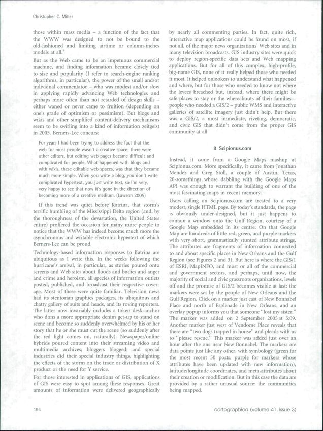
A Beast in the Field: The Google Maps Mashup as 6IS/2

unintuitive Web machines. Part of the genius of Google's        value by a participating public, a service to be mashed up,
Web applications in general, especially its search engine,      a system to be - possibly - rewired.
is the irresistible ease of the experience. Forsaking           At the time of this writing. Web developers and curious
richness, Google places in its stead speed, clarity, and        amateurs are acquiring their Google Maps API keys at
swift interaction. It should surprise none of us that           quite a clip and, with A modicum of lavaScript tweaking
most users desire little more than this from their Web          and XML coding, are building geospatial information
experiences. Those with advanced skills and advanced            resources that answer specific needs of specific commu-
needs can certainly find suitably complex systems online,       nities, industries, events, or interests. And while this is
but any hangdog librarian can attest to the fact that if        interesting, to be sure, these services could easily be
Google is considered good enough (and Google has yet to         dismissed as the result of easy tinkering with latitude/
claim to be anything more), Google will suffice. Richness       longitude coordinates. For at the time of this writing,
and depth are trumped by speed and ease, just as cheap          most of what gets put on Google Maps are x/y coordinates
trumps expensive: not always, but often. Google Maps is         (probably hand-coded) or geo-coded addresses (with all
no different. It offers no polygon layers as of this writing,   the vagaries of even the best geo-coding), concepts that
no spatial query beyond an automatic and sometimes              are easily understood by those outside the GIS commu-
loose (and sometimes completely wrong) geo-coding of            nity, lust because new populations are tinkering with
the keyword lookup - in fact, none of the advanced              geospace, this doesn't necessarily mean that GIS itself is
statistical and analysis methods that even a simple             changing.
desktop GIS might provide.' As a GIS/1, Google Maps
is admittedly light, admittedly weak, and in ordinary
circumstances might not be considered a GIS at all by the                          7 Hurricane Katrina
more rigid definers of the term.
                                                                But the time of this writing also happens to be the
Ah, but GIS/2 scholars and practitioners are not rigid          immediate and extended aftermath of Katrina, the
deftners of the term. We are open, liberal, flexible definers   hurricane that inundated the Gulf Coast of the United
of the term, and as such we are fi-ee to discuss whether        States in late August and early September 2005, resulting
any given application does or does not embody some              in 90,000 square miles of federally declared disaster area
or all of the sundry GIS/2 requisites discussed over the last   and a stunning conflagration of social and political
10 years or so. just the same, we are open to discussing        rancour. And while the stoic government response to
whether a GIS embodies the spirit of GIS/2 more than            the abject disaster has yet to be adequately explained,
it fits the tactile definitions posited in the literature       the information response of various industry commu-
thus far.                                                       nities has been wild and fervent and inspiring and
Recalling Sieber's oxymoronic (but apt) description of          ubiquitous. Already, well before Katrina, blogs and RSS
GIS/2 as "multi-vocal and contradictory" (Sieber 2004,          feeds and Podcasts and other simple and accessible
37), it becomes perfectly feasible that a GIS that has the      communication and publication media were booming.
ability to incorporate geographies that may or may not be       Development of the World Wide Web (WWW) in recent
bound to geography at iill could be a fine GIS/2 indeed -       years increased the ease with which un credent ialed
provided that it allowed for the public contribution of         citizens could report on community, state, national, or
information or insight to an analysis of or action upon         international goings-on or just contribute to some open
some more formal plan, idea, or event, of course. If a GIS      discourse. Of course, there was no dearth of commoner
could, by virtue of being open to participation, by virtue      content published to the Web before the recent rise in
of being unbound by dictocratic representations of space,       notoriety and credence of blogging, podcasting, and
by virtue of being unindebted to formal, possibly biased        information syndication, but something about how
political bodies for data, by virtue of being unencumbered      these technologies are being turned against (and, of
by the need for heavy technology and infrastructure,            course, subsequently commandeered by) traditional,
somehow assist, inform, and empower a community and             mainstream media is transforming journalism, politics,
could simultaneously comment upon, narrate to, and              and other democratic estates and therebyfi.ilfilling,at least
critique its larger, entitled, powered adversaries, would       partially, a promise of the WWW that has hitherto proved
that not make for a GIS fully worthy of a slash and a 2?        somewhat empty. Tim Berners-Lee is generally held to
In addition to matching up very well with most of the           have developed what we have come to know as the
going definitions of GIS/2, wouldn't such a beast, more         WWW, but he did so with the notion that it was to
importantly, embody their collective spirit?                    become a fantastic new communal document. The
                                                                inherent promise of that document to technologically
Fine, the question is leading. What Google Maps lacks
                                                                savvy societies held that the voices of those without could
in richness and analytical power and, indeed, accuracy,
                                                                be given more or less equal airtime or column-inches to
it makes up for by being a platform for the addition of

                                                                                                                i,

cartographica (voiume 41, issue 3)                                                                                       193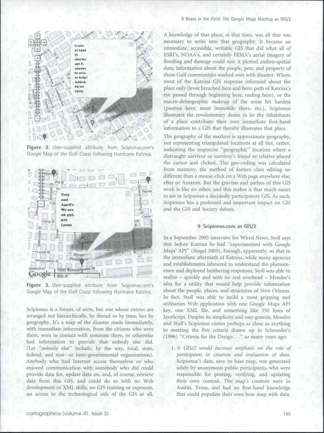
Christopher C. Miiier

those within mass media - a function of the fact that           by nearly all commenting parties. In fact, quite rich,
the WWW was designed to not be bound to the                     interactive map applications could be found on most, if
old-fashioned and limiting airtime or column-inches             not all, of the major news organizations' Web sites and in
models at all.*                                                 many television broadcasts. GIS industry sites were quick
But as the Web came to be an impetuous commercial               to deploy region-specific data sets and Web mapping
machine, and finding information became closely tied            applications. But for all of this complex, high-profile,
to size and popularity (I refer to search-engine ranking        big-name GIS, none of it really helped those who needed
algorithms, in particular), the power ofthe small and/or        it most. It helped onlookers to understand what happened
individual commentator - who was modest and/or slow             and where, but for those who needed to know not where
in applying rapidly advancing Web technologies and              the levees breached but, instead, where there might be
perhaps more often than not retarded of design skills -         safe places to stay or the whereabouts of their families -
either waned or never came to fruition (depending on            people who needed a GlS/2 - public WMS and interactive
one's grade of optimism or pessimism). But blogs and            galleries of satellite imagery just didn't help. But there
wilds and other simplified content-delivery mechanisms          was a GIS/2, a most immediate, riveting, democratic,
seem to be swirling into a kind of information Zeitgeist        and civic GIS that didn't come from the proper GIS
in 2005. Berners-Lee concurs:                                   community at all.

  For years 1 had been trying to address the fact that the
  web for most people wasn't a creative space; there were                            8 Scipionus.com
  other editors, but ediling web pages became difficult and
  complicated for people. What happened with blogs and
                                                                Instead, it came from a Google Maps mashup at
  with wikis, these editable web spaces, was that they became   Scipionus.com. More specifically, it came from lonathan
  much more simple. When you write a blog. you don't write      Mendez and Greg Stoll, a couple of Austin, Texas,
  complicated hypertext, you just write text, so I'm very,      20-somethings whose dabbling with the Google Maps
  veiy happy to see that now it's gone in the direction of      API was enough to warrant the building of one of the
  becoming more of a creative medium. (Lawson 2005)             most fascinating maps in recent memory.
                                                                Users calling on Scipionus.com are treated to a very
   If this trend was quiet before Katrina, that storm's         modest, single HTML page. By today's standards, the page
terrific humbling of the Mississippi Delta region (and, by      is obviously under-designed, but it just happens to
the thoroughness of the devastation, the United States          contain a window onto the Gulf Region, courtesy of a
entire) proffered the occasion for many more people to          Google Map embedded in its centre. On that Google
notice that the WWW has indeed become much more the             Map are hundreds of little red, green, and purple markers
asynchronous and writable electronic hypertext of which         with very short, grammatically stunted attribute strings.
Berners-Lee can be proud.                                       The attributes are fragments of information connected
Technology-based information responses to Katrina arc           to and about specific places in New Orleans and the Gulf
ubiquitous as I write this. In the weeks following the          Region (see Figures 2 and 3). But here is where the GlS/1
hurricane's arrival, in particular, as stories poured onto      of ESRI, MapINFO, and most OT all of the commercial
screens and Web sites about floods and bodies and anger         and government sectors, and perhaps, until now, the
and crime and heroism, all species of information outlets       majority of social and civic grassroots organizations, levels
posted, published, and broadcast their respective cover-        off and the promise of GIS/2 becomes visible at last: the
age. Most of these were quite familiar. Television news         markers were set by the people of New Orleans and the
had its stentorian graphics packages, its ubiquitous and        Gulf Region. Click on a marker just east of New Bonnabel
chatty gaJlery of suits and heads, and its roving reporters.    Place and north of Esplenade in New Orleans, and an
The latter now invariably includes a token desk anchor          overlay popup informs you that someone "lost my sister."
who dons a more appropriate denim get-up to stand on            The marker was added on 2 September 2005 at 5:09.
scene and become so suddenly overwhelmed by his or her          Another marker just west of Vendome Place reveals that
story that he or she must cut the scene (so suddenly after      there are "two dogs trapped in house" and pleads with us
the red light comes on, naturally). Newspaper/online            to "please rescue." This marker was added just over an
hybrids poured content into their streaming video and           hour after the one near New BonnabeL The markers are
multimedia archives; bloggers blogged; and special              data points just like any other, wnth symbology (green for
industries did their special industry things, highlighting      the most recent 50 posts, purple for markers whose
the effects of the storm on the trade or distribution of X      attributes have been updated with new information),
product or the need for Y service.                              latitude/longitude coordinates, and meta-attributes about
                                                                their creation or modification. But in this case the data are
For those interested in applications of GIS, applications
                                                                provided by a rather unusual source: the communities
of GIS were easy to spot among these responses. Great
                                                                being mapped.
amounts of information were delivered geographically

194                                                                                  cartographica (volume 41, issue 3)
A Beast in the Field: The Google Maps Mashup as GIS/2

                                                             A knowledge of that place, at that time, was all that was
                                                             necessary to write into that geography. It became an
                                                             immediate, accessible, writable GIS that did what all of
                                                             ESRI's, NOAA's, and certainly FEMA's aerial imagery of
                                                             flooding and damage could not: it plotted anthro-spatial
                                                             data, information about the people, pets, and property of
                                                             those Gulf communities washed over with disaster. Where
                                                             most of the Katrina GIS response informed about the
                                                             place only (levee breached here and here; path of Katrina's
                                                             eye passed through beginning here, ending here), or the
                                                             macro-demographic makeup of the areas hit hardest
                                                             {poorest here, most immobile there, etc.), Scipionus
3;                                                           illustrates the revolutionary desire to let the inhabitants
                                                             of a place contribute their own immediate first-hand
                                                             information to a GIS that thereby illustrates that place.
                                                             The geography of the markers is approximate geography,
                                                             not representing triangulated locations at all but, rather,
Figure 2. User-supplied attribute from Scipionuicom's        indicating the imprecise "geographic" location where a
Google Map of the Gulf Coast following Hurricane Katrina.    distraught survivor or survivor's friend or relative placed
                                                             the cursor and clicked. The geo-coding was calculated
                                                             from memory, the method of feature class editing no
                                                             different than a mouse-click on a Web page anywhere else,
                                                             eBay or Amazon. But the gravitas and pathos of this GIS
                                                             work is like no other, and this makes it that much easier
                                                             to see in Scipionus a decidedly participatory GIS. As such,
                                                             Scipionus has a profound and important impact on GIS
                                                             and the GIS and Society debate.

                                                                            9 Scipionus.com as GIS/2          '    ^    .,

                                                             In a September 2005 interview for Wired News, Stoll says
                                                             that before Katrina he had "experimented with Google
                                                             Maps' API" (Singel 2005). Enough, apparently, so that in
                                                             the immediate aftermath of Katrina, while many agencies
                                                             and establishments laboured to understand the phenom-
                                                             enon and deployed lumbering responses, Stoll was able to
Google                                                       realize - quickly and with no real overhead - Mendez's
Figure 3. User-supplied attribute from Scipionus.com's       idea for a utility that would help provide information
Google Map of the Gulf Coast following Hurricane Katrina.
                                                             about the people, places, and structures of New Orleans.
                                                             In fact, Stoll was able to build a most gripping and
                                                             utilitarian Web application with one Google Maps API
Scipionus is a forum, of sorts, but one whose entries are    key, one XNIL file, and something like 350 lines of
arranged not hierarchically, by thread or by time, but by    JavaScript. Despite its simplicity and easy genesis, Mendez
geography. It's a map of the disaster made immediately,      and Stoll's Scipionus comes perhaps as close as anything
with immediate information, from the citizens who were       to meeting the five criteria drawn up in Schroeder's
there, were in contact with someone there, or otherwise      (1996) "Criteria for the Design..." so many years ago:
had information to provide that nobody else did.
(Let "nobody else" include, by the way, local, state,           1. A GIS/2 would increase emphasis on the role of
federal, and non- or inter-governmental organizations).            participants in creation and evaluation of data.
Anybody who had Internet access themselves or who                  Scipionus's data, save its base map, was generated
enjoyed communication with somebody who did could                  solely by anonymous public participants, who were
provide data for, update data on, and, of course, retrieve         responsible for posting, verifying, and updating
data from this GIS, and could do so with no Web                    their own content. The map's creators were in
development or XML skills, no GIS training or exposure,            Austin, Texas, and had no first-hand knowledge
no access to the technological side of the GIS at all.             that could populate their own base map with data.

cartographica (volume 41, Issue 3)                                                                                     195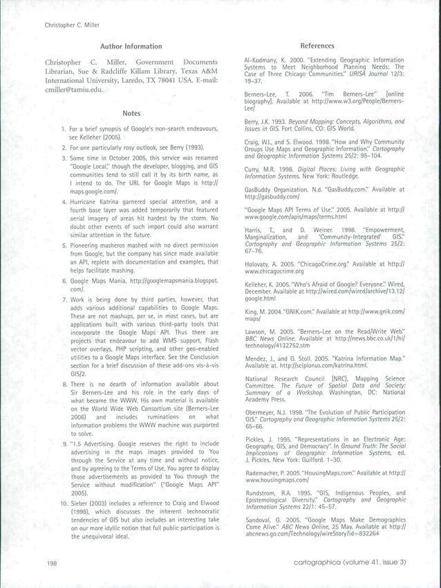
Christopher C. Miller

                                           KI.ZUaig3BZ6;»l'up1k>ne->b]ualJuiIi[>alu:')a.UDligiSTnBt«4- I                                         Huni C!t9(..lam
                                                                              fiolHooBinflwco'ifld h*r(" ••
                                                       761183- Liatmr-riami Cauchc - Tr«i.          tii Oown. «
                                          '-*0.003«3ii27Sl*06't«)l*)nr'No (looOIng, slight In n
                                                                                        fl            n«e. liK
                                                                             of !>«•> down, B
A Beast in the Field; The Google Maps Mashup as G15/2
10 Conclusion and Notes about the Future programs and utilities is available ah-eady that follow a
similar model; a technically minded agent builds a system
The growing archive of GIS/2 debate contains myriad that can be used by the non-technically minded to
proposals, models, and critiques that address what GIS generate content out of their own data or local knowledge.
can, cannot, or should do. Consistent through all of this These utilities are multiplying at an accelerated clip and
gurgitation, however, are the high-minded principles of have, in fact, expanded to incorporate the growing
equality, social action, political access, demarginalization, interest in Google Earth (and, to a lesser extent, NASA's
and enfranchisement. Democracy itself, in other words. WorldWind). So by early 2006, if one needs to place
And in the early days of September 2005, as federal images to specific places on a map. Web sites exist to help
bureaucrats appeared before Ted Koppel and Anderson do that; if one needs to plot points or tracks recorded
Cooper to explain why thousands of people were dead by a GPS receiver. Web sites exist; if one needs a simple
or dying or at that moment going uninformed and geo-coder that happens to output into Google Maps
unassisted, why they had yet to receive any help in or even Google Earth or WorldWind, Web sites exist.
locating loved ones, any information about the So while it is currently not likely that a user hitherto
state of the rescue effort, or any help at all, in most unindoctrinated into the world of geospatial systems
cases, the demos employed - or, in the case of Scipionus, and analysis can obtain a Google Maps API key and
built - tools and systems and processes that allowed begin doing GIS with it, the likelihood is multiplying
citizens to help and inform themselves. The most novel exponentially that such users will find some utility or
and compelling of these, the most portentous of program to assist them.
what might come, was Scipionus. It dispensed with a
remarkable number of the things, abstraction and But the point here is not to keep up with Internet
philosophy among them, that GIS/2 scholars dream time or to speculate about Google's true intentions.
about in their sleep. And even if I grant that Scipionus They are commercial; let's leave it at that. It is also
may not really be a fully formed GIS/2, there is stiil not terribly valuable to work on imagining a world of
this question pulling on my coat; Should a proper, technology with no technorati. The point is that the
fully rewired GIS/2 really come along, will we know it Google Maps mashups model has put into public practice
when we see it? the notion that an accessible, agile, adaptable GIS can
be built that accepts direct, local, even vernacular public
There is, admittedly, some dissonance between the input and, in turn, puts out usable, unique, localized,
idea of GIS/2 as a bastion of democratic action and a and important results. The model exists, and rudimentary
GIS whose base-map data and server-side functionality applications have been built, so what is to prevent
are provided, in closed code, solely by one of the most Google from building additional functionality into their
unabashedly dot-com dot-coms around. This is a very system? If the company specializes in anything (other
legitimate concern, as the conventional wisdom as of this than making money), it is ease-of-use. Where there are
writing is that Google Maps is being developed as a brood now point-data layers indicating crime events, housing
mare for commercial advertising, not as an open, scalable opportunities, and stars' homes, then, there could just as
GIS. Location-based advertising is garnering much buzz easily be individual polygon layers that depict this
these days, and Google is wise to release such an accessible community or that area of concern. What is to prevent
and geo-enabled product after which advertisers can lust. Google from allowing the creation of sketches and
The Google Maps API key agreement states quite clearly annotations? And what if they were somehow connected
that Google reserves the right to advertise at any time to a database? What is to prevent them from building the
through any of the data it serves/"* Furthermore, it should interactive. Web-based whiteboard that would allow any
be said that the coding that puts data on the map isn't community member ("community" being loosely trans-
coming from the Word and PowerPoint rank-and-file. lated here to mean "any person in the world with access to
A formidable amount of coding goes into the more a networked computer") to sketch an idea that instantly
advanced mashups, and there would be much, much becomes stored as a geography? What is to prevent them,
more should the system come to incorporate anything in other words, from building a versioned, writeable
more than point (lat/long) data. But, as Sieber reminds us geographic space upon which ordinary participants
as a caveat to her XML example, dot-orgs were somehow can illustrate, analyse, and present their own ideas
able to swallow HTML with little trouble (2004, 36). And of geographic and community space? To put it another
if you've spent any time married to HTML, you've almost way, what is to prevent Google - Google, Inc. - from
certainly dated lavaScript. It begs questions about giving birth to the first sustainable, living GIS/2?
technocracy, but all GlS/2 does.'" What perhaps matters The question is rhetorical, or, at least, posed for later
most is how easily participation can be built into a GIS. discussion. But if you're inclined to answer with
"money," "time," "demand," or "developer attention,"
The Scipionus site was built by Web developers don't bother. . ,
rather than GIScientists, and a remarkable number of
cartographica (volume 41, issue 3) 197Christopher C. Miller
Author Information References
Christopher C. Miller, Government Documents Al-Kodmany, K. 2000. "Extending Geographic Information
Systems to Meet Neighborhood Planning Needs: The
Librarian, Sue & RadcUffe Killam Library, Texas A&M Case of Three Chicago Communities." URI5A Journal 12/3:
International University, Laredo, TX 78041 USA. E-mail: 19-37.
cmiller@tamiu.edu.
Berners-Lee, I 2006. "Tim Berners-Lee" (online
biography]. Available at http://www.w3.org/People/Berners-
Lee/
Notes
Berry, J.K. 1993. Beyond Mapping: Concepts, Algorithms, ond
1. For a brief synopsis of Google's non-search endeavours, Issues in GIS. Fort Coilins, CO: GIS World.
see Kelleher (2005).
Craig, WJ., and S. Elwood. 1998. "How and Why Community
2. For one particularly rosy outlook, see Berry (1993), Groups Use Maps and Geographic Information," Cartography
3. Some time in October 2005, this service was renamed and Geographic Information Systems 25/2: 95-104.
"Google Local," though the developer, blogging, and GIS Curry, M.R. 1998. Digital Places: Living with Geographic
communities tend to still call it by its birth name, as Information Systems. New York: Routledge.
I intend to do. The URL for Google Maps is http;//
maps.google.com/. ;, GasBuddy Organization. N.d. "GasBuddy.com." Available at
http ://gasbuddy com/
4. Hurricane Katrina garnered special attention, and a
fourth base layer was added temporarily that featured "Google Maps API Terms of Use." 2005. Available at http://
aerial imagery of areas hit hardest by the storm. No www.google.com/apis/maps/terms.html
doubt other events of such import could also warrant
Harris, I , and D. Weiner. 1998. "Empowerment,
similar attention in the future. Marginatization, and 'Community-Integrated' GIS."
5. Pioneering masheros mashed with no direct permission Cartography and Geographic Information Systems 25/2:
from Google, but the company has since made available 67-78.
an API, replete with documentation and examples, that Holovaty, A. 2005. "ChicagoCrime.org." Available at http://
helps facilitate mashing. www.chicagocrime.org
6. Google Maps Mania, http://googlemapsmania.blogspot
Kelteher, K. 2005."Who's Afraid of Google? Everyone." Wired,
com/. December. Available at http://wired.com/wired/archive/13.12/
7. Work is being done by third parties, however, that google.html
adds various additional capabilities to Google Maps.
King, M. 2004."GNiK.com." Available at http://www.gnik.com/
These are not mashups, per se, in most cases, but are maps/
applications built with various third-party tools that
incorporate the Google Maps API. Thus there are Lawson, M. 2005. "Berners-Lee on the Read/Write Web."
projects that endeavour to add WMS support. Rash BBC News Online. Available at http://news.bbc.co.Uk/l/hi/
technology/4132752.stm
vector overlays, PHP scripting, and other geo-enabled
utilities to a Google Maps interface. See the Conclusion Mendez, J., and G. Stoll. 2005. "Katrina Information Map."
section for a brief discussion of these add-ons vis-a-vis Available a t http.7/scipionus.com/katrina.htm!.
GlS/2.
National Research Council [NRC], Mapping Science
8. There is no dearth of information available about Committee. T?je Future of Spatial Data and Society:
Sir Berners-Lee and his role in the early days of Summary of a Wori(shop. Washington, DC: National
what became the WWW. His own material is available Academy Press.
on the World Wide Web Consortium site (Berners-Lee
Obermeyer, NJ. 1998. "The Evoiutlon of Public Participation
2006) and includes ruminations on what GIS." Cartography and Geographic Information Systems 25/2:
information problems the WWW machine was purported 65-66.
to solve.
Pickles, J. 1995. "Representations in an Electronic Age:
9. "1.5 Advertising. Google reserves the right to include Geography, GIS, and Democracy". In Ground Truth: The Social
advertising in the maps images provided to You Implications of Geographic Information Systems, ed.
through the Service at any time and without notice, J. Pickles. New York: Guilford. 1-30,
and by agreeing to the Terms of Use, You agree to display
Rademacher, P. 2005. "HousingMaps.com," Available at http://
those advertisements as provided to You through the
www.housingmaps.com/
Service without modification" ("Google Maps API"
2005). Rundstrom. R,A. 1995. "GIS, Indigenous Peoples, and
Epistemological Diversity." Cartography and Geographic
10. Sieber (2003) includes a reference to Craig and Elwood
Information Systems 22/1: 45-57.
(1998), which discusses the inherent technocratic
tendencies of GIS but also includes an interesting take Sandoval, G. 2005, "Google Maps Make Demographics
on our more idyllic notion that full public participation is Come Alive." ABC News Online. 25 May. Available at http://
the unequivocal ideal. abcnews.go.com/Technology/wireStory?ld=832264
198 cartographica (volume 41, Issue 3)You can also read