A Consensus Study Report of
←
→
Page content transcription
If your browser does not render page correctly, please read the page content below
Framing the Challenge of Urban Flooding in the United States

                                      Committee on Urban Flooding in the United States

                                       Program on Risk, Resilience, and Extreme Events
                                                  Policy and Global Affairs

                                                 Water Science and Technology Board
                                                  Division on Earth and Life Studies

                                                        A Consensus Study Report of

                                            Copyright National Academy of Sciences. All rights reserved.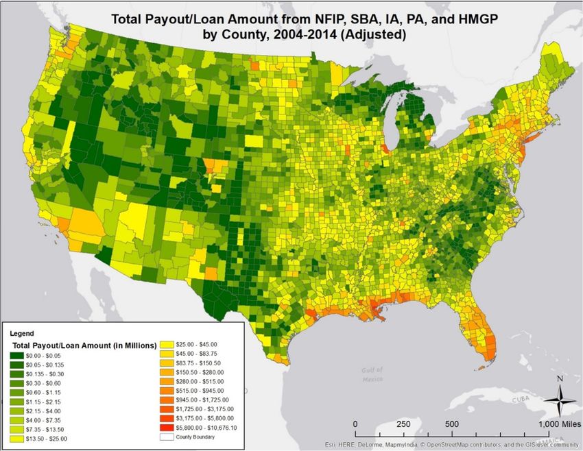
Framing the Challenge of Urban Flooding in the United States

                 THE NATIONAL ACADEMIES PRESS 500 Fifth Street, NW Washington, DC 20001

                 This activity was supported by a contract between the National Academy of Sciences and the Federal
                 Emergency Management Agency (Award No. HSFE20-16-C-0211). Any opinions, findings, conclusions,
                 or recommendations expressed in this publication do not necessarily reflect the view of the organization
                 that provided support for the project.

                 International Standard Book Number-13: 978-0-309-48961-4
                 International Standard Book Number-10: 0-309-48961-X
                 Digital Object Identifier: https://doi.org/10.17226/25381

                 Additional copies of this publication are available for sale from the National Academies Press, 500 Fifth
                 Street, NW, Keck 360, Washington, DC 20001; (800) 624-6242 or (202) 334-3313; http://www.nap.edu.

                 Copyright 2019 by the National Academy of Sciences. All rights reserved.

                 Printed in the United States of America

                 Suggested citation: National Academies of Sciences, Engineering, and Medicine. 2019. Framing the
                 Challenge of Urban Flooding in the United States. Washington, DC: The National Academies Press. doi:
                 https://doi.org/10.17226/25381.

                                            Copyright National Academy of Sciences. All rights reserved.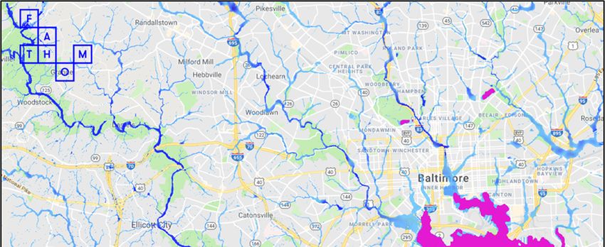
Framing the Challenge of Urban Flooding in the United States

                 The National Academy of Sciences was established in 1863 by an Act of Congress, signed by
                 President Lincoln, as a private, nongovernmental institution to advise the nation on issues
                 related to science and technology. Members are elected by their peers for outstanding
                 contributions to research. Dr. Marcia McNutt is president.

                 The National Academy of Engineering was established in 1964 under the charter of the
                 National Academy of Sciences to bring the practices of engineering to advising the nation.
                 Members are elected by their peers for extraordinary contributions to engineering. Dr. C. D.
                 Mote, Jr., is president.

                 The National Academy of Medicine (formerly the Institute of Medicine) was established in 1970
                 under the charter of the National Academy of Sciences to advise the nation on medical and
                 health issues. Members are elected by their peers for distinguished contributions to medicine
                 and health. Dr. Victor J. Dzau is president.

                 The three Academies work together as the National Academies of Sciences, Engineering, and
                 Medicine to provide independent, objective analysis and advice to the nation and conduct other
                 activities to solve complex problems and inform public policy decisions. The National Academies
                 also encourage education and research, recognize outstanding contributions to knowledge, and
                 increase public understanding in matters of science, engineering, and medicine.

                 Learn more about the National Academies of Sciences, Engineering, and Medicine at
                 www.nationalacademies.org.

                                            Copyright National Academy of Sciences. All rights reserved.
Framing the Challenge of Urban Flooding in the United States

                 Consensus Study Reports published by the National Academies of Sciences, Engineering, and
                 Medicine document the evidence-based consensus on the study’s statement of task by an
                 authoring committee of experts. Reports typically include findings, conclusions, and
                 recommendations based on information gathered by the committee and the committee’s
                 deliberations. Each report has been subjected to a rigorous and independent peer-review
                 process and it represents the position of the National Academies on the statement of task.

                 Proceedings published by the National Academies of Sciences, Engineering, and Medicine
                 chronicle the presentations and discussions at a workshop, symposium, or other event convened
                 by the National Academies. The statements and opinions contained in proceedings are those of
                 the participants and are not endorsed by other participants, the planning committee, or the
                 National Academies.

                 For information about other products and activities of the National Academies, please visit
                 www.nationalacademies.org/about/whatwedo.

                                            Copyright National Academy of Sciences. All rights reserved.
Framing the Challenge of Urban Flooding in the United States

                                COMMITTEE ON URBAN FLOODING IN THE UNITED STATES

                 Members

                 DAVID R. MAIDMENT (Chair), University of Texas at Austin
                 CHAD BERGINNIS, Association of State Floodplain Managers, Madison, Wisconsin
                 LT. GEN. (RET.) THOMAS P. BOSTICK, Intrexon, Germantown, Maryland
                 SAMUEL BRODY, Texas A&M University, College Station
                 JEFFERY CZAJKOWSKI, University of Pennsylvania, Philadelphia, and National
                 Association of Insurance Commissioners, Kansas City, Missouri
                 DARA ENTEKHABI, Massachusetts Institute of Technology, Cambridge
                 HARRIET FESTING, Anthropocene Associates, Chicago, Illinois
                 KATHERINE GREIG, University of Pennsylvania, Philadelphia
                 JO ANN HOWARD, H2O Partners Inc., Austin, Texas
                 CONOR JENSEN, Renegade Science, Oswego, Illinois
                 ERIC TATE, University of Iowa, Iowa City
                 CLAIRE WELTY, University of Maryland, Baltimore County
                 JAMES L. WESCOAT, Massachusetts Institute of Technology, Cambridge

                 Study Staff

                 LAUREN ALEXANDER AUGUSTINE, Study Director
                 ANNE LINN, Scholar, Board on Earth Sciences and Resources
                 ERIC EDKIN, Program Coordinator, Board on Earth Sciences and Resources

                                                                         v

                                            Copyright National Academy of Sciences. All rights reserved.
Framing the Challenge of Urban Flooding in the United States

                                            Copyright National Academy of Sciences. All rights reserved.
Framing the Challenge of Urban Flooding in the United States

                                                               Acknowledgments

                           This Consensus Study Report was reviewed in draft form by individuals chosen for their diverse
                 perspectives and technical expertise. The purpose of this independent review is to provide candid and
                 critical comments that will assist the National Academies of Sciences, Engineering, and Medicine in
                 making each published report as sound as possible and to ensure that it meets the institutional standards for
                 quality, objectivity, evidence, and responsiveness to the study charge. The review comments and draft
                 manuscript remain confidential to protect the integrity of the deliberative process.
                           We thank the following individuals for their review of this report: Philip Bedient, Rice
                 University; Timothy Collins, University of Utah; Kimberly Grove, Baltimore City Department of Public
                 Works; Eric Klinenberg, New York University; Ning Lin, Princeton University; Jay Lund, University of
                 California, Davis; David Miller, Electric Infrastructure Security Council; Doug Plasencia, Moffatt &
                 Nichol; and P. Kay Whitlock, Christopher B. Burke Engineering, Ltd.
                           Although the reviewers listed above provided many constructive comments and suggestions, they
                 were not asked to endorse the conclusions or recommendations of this report nor did they see the final draft
                 before its release. The review of this report was overseen by Michael Kavanaugh, Geosyntec Consultants,
                 and David Dzombak, Carnegie Mellon University. They were responsible for making certain that an
                 independent examination of this report was carried out in accordance with the standards of the National
                 Academies and that all review comments were carefully considered. Responsibility for the final content
                 rests entirely with the authoring committee and the National Academies.
                           A central part of this study was stakeholder workshops, meetings, interviews, and site visits in
                 four metropolitan areas: Baltimore, Chicago, Houston, and Phoenix. The participants in these activities are
                 listed in Appendixes B through E, and the committee thanks them for their insights on urban flooding in
                 their area. The committee also thanks the following individuals for making maps, compiling data, carrying
                 out literature searches, or making other contributions to the report: Federico Antolini, University of Iowa;
                 Oronde Drakes, University of Iowa; Wesley E. Highfield, Texas A&M, Galveston; Asif
                 Rahman, University of Iowa; Jayton Rainey, Texas A&M, College Station; and Oliver Wing, University
                 of Bristol.

                                                                        vii

                                            Copyright National Academy of Sciences. All rights reserved.
Framing the Challenge of Urban Flooding in the United States

                                            Copyright National Academy of Sciences. All rights reserved.
Framing the Challenge of Urban Flooding in the United States

                                                                  Contents

                 SUMMARY                                                                                   1

                 1        INTRODUCTION                                                                     9
                          What Is Urban Flooding?, 9
                          Committee Charge and Approach, 12
                          Organization of This Report, 13

                 2        INSIGHTS FROM FOUR METROPOLITAN AREAS                                            15
                          Local Reflections from Baltimore, Maryland, 15
                          Local Reflections from Houston, Texas, 17
                          Local Reflections from Chicago, Illinois, 21
                          Local Reflections from Phoenix, Arizona, 23
                          Commonalities and Differences Among the Four Metropolitan Areas, 26

                 3        MAGNITUDE OF URBAN FLOODING                                                      29
                          Historical Data Assessments, 29
                          Flood Risk Assessments, 43
                          Magnitude of Flooding in the Case Study Areas, 47

                 4        A WAY FORWARD ON URBAN FLOODING                                                  51
                          Physical Dimensions of Urban Flooding, 51
                          Social Dimensions of Urban Flooding, 52
                          Information Dimensions of Urban Flooding, 58
                          Actions and Decision-Making Dimensions of Urban Flooding, 60
                          Concluding Observations, 62

                 REFERENCES                                                                                63

                 APPENDIXES
                 A    Trends Affecting Urban Flooding                                                      69
                 B    Baltimore Case Study                                                                 75
                 C    Houston Case Study                                                                   79
                 D    Chicago Case Study                                                                   83
                 E    Phoenix Case Study                                                                   87
                 F    Acronyms and Abbreviations                                                           89

                                                                         ix

                                            Copyright National Academy of Sciences. All rights reserved.
Framing the Challenge of Urban Flooding in the United States

                                            Copyright National Academy of Sciences. All rights reserved.
Framing the Challenge of Urban Flooding in the United States
Summary
Flooding is the natural hazard with the greatest economic and social impact in the United States,
and these impacts are becoming more severe over time. Catastrophic flooding from recent hurricanes,
including Superstorm Sandy in New York (2012) and Hurricane Harvey in Houston (2017), caused
billions of dollars in property damage, adversely affected millions of people, and damaged the economic
well-being of major metropolitan areas. Flooding takes a heavy toll even in years without a named storm
or event. Major freshwater flood events from 2004 to 2014 cost an average of $9 billion in direct damage
and 71 lives annually. These figures do not include the cumulative costs of frequent, small floods, which
can be similar to those of infrequent extreme floods.
The Federal Emergency Management Agency (FEMA) helps communities with flood preparation,
mitigation, response, and recovery. It carries out these functions by analyzing and mapping flood hazard,
providing federal flood insurance, and disbursing grants and loans to individuals and businesses after
presidentially declared flood disasters. FEMA’s flood hazard analysis and mapping focus on inundation
from riverine and coastal flooding. Within cities, however, flood damage can occur anywhere, not just in
floodplains along rivers and coasts. Impacts can be highly localized due to small- scale differences in
topography, storm characteristics, storm water management infrastructure, and building design. In
addition, with about 280 million people living in U.S. urban areas, the social and economic impacts of
urban flooding can be particularly severe. With mounting costs, Congress and FEMA recognize that the
causes and consequences of urban flooding need focused examination.
At the request of FEMA, the National Academies of Sciences, Engineering, and Medicine
appointed a committee to hold workshops to gain an initial understanding of the causes and impacts of
urban flooding in three to eight metropolitan areas, and to use that information to address three tasks:
1. Identify any commonalities and variances among the case study metropolitan areas in terms
of causes, adverse impacts, unexpected problems in recovery, or effective mitigation
strategies, as well as key themes of urban flooding;
2. Provide an estimate of the size or importance of flooding in those urban areas; and
3. Relate, as appropriate, causes and actions of urban flooding to existing federal resources or
policies, including but not limited to the National Flood Insurance Program, nondisaster
grants, Stafford Act authorities, or others.
The objective was to contribute to existing knowledge by providing some real-world examples in
specific places, based largely on regional workshops, and not to provide a comprehensive overview of
urban flooding in the United States.
The workshop orientation ties directly to Task 1, but it posed problems for addressing Tasks 2
and 3. To estimate the magnitude of urban flooding (Task 2), the committee drew on published estimates
of flood losses in the case study areas and also analyzed federal flood loss data. For Task 3—relating
urban flooding causes and actions to federal resources—the committee focused on needs that were
identified in the case studies or the committee’s loss calculations and that are strongly connected to
federal resources and policies.
The committee’s definition of urban flooding and response to the three tasks are given below.
1
Copyright National Academy of Sciences. All rights reserved.Framing the Challenge of Urban Flooding in the United States
Framing the Challenge of Urban Flooding in the United States
WHAT IS URBAN FLOODING?
Urban flooding is caused when the inflow of storm water in urban areas exceeds the capacity of
drainage systems to infiltrate storm water into the soil or to carry it away. The inflow of storm water
results from (a) heavy rainfall, which can collect on the landscape (pluvial flooding) or cause rivers and
streams to overflow their banks and inundate surrounding areas; or (b) storm surge or high tides, which
push water onto coastal cities. Floodwater inundation and movement are influenced by (a) land
development, which disturbs natural drainage patterns and creates hardened surfaces that inhibit
infiltration of storm water; and (b) storm water systems that are undersized for current needs and increase
exposure to drainage hazards. In older cities, sewer systems carrying both storm water and wastewater
can become surcharged during storms, causing sewer backups in homes—an often chronic and unseen
form of urban flooding.
TASK 1: COMMONALITIES AND DIFFERENCES AMONG FOUR METROPOLITAN AREAS
A major thrust of this study involved visiting different metropolitan areas to examine urban
flooding in different parts of the United States. The committee selected four disparate metropolitan areas
to examine: Baltimore City and Baltimore County in Maryland, the City of Chicago and Cook County in
Illinois, the City of Houston and Harris County in Texas, and the City of Phoenix and Maricopa County in
Arizona. The committee visited each case study area and hosted a workshop with stakeholders,
including city or county engineers responsible for flood management, nonprofit organizations, community
groups, and residents. Such approaches emphasize idea generation and information exchange, rather than
systematic evaluation.
The four case study workshops, site visits, and interviews showed that each metropolitan area has
its own flavor of urban flooding. Baltimore participants did not identify with the term urban flooding.
Although they noted that flooding occurs along Jones Falls and the low-lying areas near the harbor, the
workshop participants seemed more concerned about basement flooding and sinkholes. In contrast,
Houston area residents have been living with severe flooding for generations. Even though the Houston
workshop was held before Hurricane Harvey, the participants demonstrated a high awareness of urban
flooding and its impacts. The Chicago metropolitan area is also prone to several sources of flooding,
including sewer backups into basements. Workshop participants had a high awareness of urban flooding as
well as government and neighborhood efforts to lesson flood impacts. The Phoenix metropolitan area
suffers from comparatively few floods, and many of these are flash floods. In lieu of a workshop with a
variety of local stakeholders, the committee met with subject matter experts to discuss some innovative
approaches to flood control in an arid climate.
Discussions at the workshops and meetings were organized around four dimensions of urban
flooding: (1) physical—the built and natural environments, (2) social—impacts on people, (3)
information—data used to understand or communicate flood events, and (4) actions and decision
making—steps and policies for managing flooding. Key similarities and differences among the four
metropolitan areas identified by the case study participants are summarized below.
Physical Dimensions. Each of the case study areas has a unique urban flood hazard defined by its natural
environment (e.g., land cover, topography, soil type, and rainfall), history and pattern of land
development (e.g., sprawling or dense), and type of storm water and sewage systems. A key difference
among the case study areas was the sources of flooding: riverine (Baltimore), coastal (Baltimore,
Houston, and Chicago [Great Lakes]), flash (Phoenix), and pluvial flooding (all four areas), as well as
sewer backups (Chicago and Baltimore). Decisions on land development and design or maintenance of
infrastructure were seen to amplify the intensity and influence the location of flood impacts in each
metropolitan area.
2
Copyright National Academy of Sciences. All rights reserved.Framing the Challenge of Urban Flooding in the United States
Summary
Social Dimensions. Flooding crosses the economic spectrum, but workshop sessions and interviews paint
a clear picture that the poor, racial and ethnic minorities, the elderly, renters, non-native English speakers,
and those with mobility challenges were disproportionately affected by floods in each area. A major
difference across the metropolitan areas was the level of citizen empowerment, which ranged from highly
organized neighborhood and citizen groups (Chicago) to low levels of citizen engagement (Baltimore).
Information Dimensions. Stakeholders in all four metropolitan areas lamented a lack of data on urban
flood hazard, flooding at local scales, or the economic costs and social impacts of urban flooding. In the
absence of better information, managers and residents are using FEMA’s Flood Insurance Rate Maps to
estimate where flooding will occur in urban areas. Some metropolitan areas are working to fill these gaps.
For example, Harris County has developed local flood models, and Maricopa County and its partners are
producing flood maps for transportation and flood warning purposes.
Actions and Decision-Making Dimensions. People in each metropolitan area wanted ongoing urban
flood management efforts (e.g., buyouts of chronically flooded properties in Houston), and they noted the
importance and the challenges of working toward solutions for urban flooding across jurisdictional divides.
The range of collaborative projects across and among jurisdictions resulted in substantial engineering
projects (the Tunnel and Reservoir Plan [TARP] in Chicago or Brays Bayou in Houston), large-scale blue-
green solutions for flood (Indian Bend Wash in Maricopa County), and information- sharing efforts for
flash flood warning systems (Arizona Department of Transportation Resilience Program).
Finding: Each of the study areas (Baltimore, Houston, Chicago, and Phoenix) has a unique flood
hazard and manages urban flooding in its own way, using a tailored mix of federal, state, local, and
nongovernmental financial and information resources. In each metropolitan area visited, the impacts of
flooding are particularly felt by disenfranchised populations. All four dimensions (physical, social,
information, and actions and decision making) are needed to understand and manage urban flooding.
TASK 2: SIZE OR IMPORTANCE OF URBAN FLOODING
Task 2 sought to answer the question, “how big is the problem of urban flooding?” Workshop
participants in each metropolitan area felt that urban flooding is important in their area. However,
quantifying the magnitude of urban flooding is challenging because flooding can result in a wide variety
of economic, social, and ecological impacts, all of which vary geographically. Impacts include the
following:
1. Direct impacts—Immediate effect of the disaster (e.g., loss of life; damage to buildings, roads,
agriculture, and infrastructure; monetary loss).
2. Indirect impacts—Result from the direct impacts in the medium to long term (e.g., increased
morbidity due to lack of sanitation facilities; unemployment and reduced income due to business and
transportation interruption).
3. Tangible impacts—Impacts that have a market value and can generally be measured in monetary
terms (e.g., structural losses).
4. Intangible impacts—Nonmarket impacts (e.g., health, natural resources, cohesion of a social
group or community).
Although indirect and intangible impacts can be substantial, direct and tangible impacts are easier
to measure. Thus, direct and tangible impacts are more commonly used to estimate the magnitude of urban
flooding.
3
Copyright National Academy of Sciences. All rights reserved.Framing the Challenge of Urban Flooding in the United States
Framing the Challenge of Urban Flooding in the United States
The two main methods for estimating the magnitude of flooding are (1) a descriptive or statistical
assessment of historical flood impact data (retrospective estimate) and (2) an urban flood risk assessment
(prospective estimate).
Historical Estimates of Urban Flood Losses
FEMA collects the most complete, consistent, and accessible data on historical flood losses.
FEMA data include claims for property losses insured by the National Flood Insurance Program, loans for
Small Business Assistance, and grants to cover immediate unmet recovery needs of individuals
(Individual Assistance), assistance for publicly owned facilities (Public Assistance), and hazard
mitigation projects and buyouts (Hazard Mitigation Grant Program). Data are available at the county
level.
To estimate urban flood losses, the committee summed the dollar amounts from these five FEMA
data sets over a 10-year period (2004–2014), then adjusted the figures to 2014 prices. For the 10 analyzed
years, the total payouts, grants, and loans for case study counties were $2.7 billion for Harris County, $1.8
billion for Cook County, $38 million for Baltimore County, and $11 million for Maricopa County. Losses
for Harris County would be considerably higher if the data set included Hurricane Harvey. Across the
United States, FEMA data show that flood losses are greatest in heavily populated coastal counties,
driven by coastal storm-induced flooding. For example, the significant flood events of Hurricane Katrina
and Superstorm Sandy drove the urban flood losses for New York and Louisiana, which received payouts,
loans, and grants on the order of $10 billion from 2004 to 2014.
Flood Risk Assessments
Flood risk assessments comprise four main components: (1) flood hazard—the probability and
magnitude of the urban flood hazard, (2) exposure—the population and economic assets at risk, (3)
vulnerability—the damage relationship between hazard and exposure, and (4) performance—accounting for
any flood mitigation measures such as levees. Flood risk assessments offer a more comprehensive, but still
incomplete, picture of urban flooding than historical estimates because they include a wider range of flood
probabilities and some nonproperty damages. As a result, their estimates of flood damage and population
affected are higher, sometime substantially, than estimates based on historical data. The few published risk
assessments for the case study metropolitan areas found that 2.8 million people are exposed to flooding,
more than triple the number estimated by FEMA. In addition, studies estimate that average annual losses
are $3.3 billion for both Chicago and Houston and $76 million for Baltimore, more than 20 times higher
than historical estimates.
Both historical estimates and flood risk assessments likely underestimate flood losses. Much of
the historical data is derived from presidentially declared flood events, which miss impacts from less
extreme but more frequent flood events. They also exclude uninsured property and indirect losses. Many
flood risk assessments do not consider pluvial flooding, which is an important source of urban flooding,
and they include only a few nonproperty damages.
Finding: Existing data are inadequate to provide an accurate monetary estimate of the magnitude
of urban flooding. Historical loss estimates for the counties that include Chicago and Houston average
$200 million per year (for 2004–2014) in each county. However, losses likely far exceed these
estimates—possibly on the order of a few billion dollars per year—when pluvial flooding, uninsured
property and indirect losses, declines in gross domestic product, and the millions of urban residents
exposed to flooding are considered in a flood risk assessment. Although historical flood losses are lower
in the counties that include Baltimore and Phoenix (few million dollars per year), actual losses are likely
much higher when the other contributing factors are considered.
4
Copyright National Academy of Sciences. All rights reserved.Framing the Challenge of Urban Flooding in the United States
Summary
TASK 3: CONNECTION OF FEDERAL RESOURCES TO URBAN FLOODING
Task 3 was to relate FEMA and other federal resources to causes and actions related to urban
flooding. Key needs with a strong federal connection concern understanding and communicating urban
flood hazard and flood risk, understanding and mitigating the social impacts of urban flooding, and
coordinating activities of organizations with a role in managing urban flooding.
Urban Flood Hazard
A key need identified in the case study areas was a better understanding of urban flood hazard.
FEMA has established methods for analyzing several types of flood hazard, such as riverine or coastal
flood hazard. However, methods for analyzing urban flood hazard will have to incorporate urban
components, such as the capacity of storm water systems, as well as the small topographic variations,
local drainage patterns, and site-specific structural designs that drive the granular nature of urban flood
impacts.
Finding: An established method for analyzing urban flood hazard is needed. FEMA is well positioned
to take a leading role in guiding this development effort by virtue of its mission and expertise in analyzing
various types of flood hazards. Important partners include local government agencies, which know their
storm water systems and local land characteristics, and organizations developing hydrologic or hydraulic
models that account for pluvial flooding and other factors. Urban flood hazard analyses would also
contribute to urban flood risk assessments being developed by academic researchers and private
companies.
Socially Vulnerable Populations
A point raised repeatedly in the case study workshops and interviews is that while severe storms
fall on the rich and poor alike, the capacity to respond to and recover from flooding is much lower in
socially vulnerable populations that even in the best of times are struggling to function. This point is
supported by research on social vulnerability and flood hazard impacts. However, the social dimensions
of urban flooding are far less studied and understood than the physical dimensions. Academic studies
focused on communities affected by urban floods would yield valuable insights. Data on intangible
impacts (e.g., health or community cohesion), indirect impacts (e.g., unemployment due to business
interruption), and additional vulnerability drivers (e.g., risk perception and social capital) would help
improve urban flood risk assessments. Data collection and analysis could also reveal ways to build
effective social networks or to support civic organizations that help residents increase their social agency,
capacity, and capability for adjusting to flood hazards.
Finding: Greater investments are needed to research, understand, and develop interventions to
mitigate the social impacts of urban flooding and their disparate effects across populations.
Although the National Science Foundation is the primary funder of social science research, FEMA, the
U.S. Army Corps of Engineers, and the Centers for Disease Control and Prevention have promoted
accounting for and engaging socially vulnerable populations in the planning and response to hazard
events.
Communicating Urban Flood Hazard and Flood Risk
The case study workshops showed that people want to know and understand their flood risk—the
flood hazard as well as the consequences of it occurring, such as property damage and business, school,
and transportation disruptions. Maps and visualizations are a primary means of communicating flood risk.
Maps that show relative risk rather than probability, or that offer improved searchability or address look-
up would be useful to the public.
5
Copyright National Academy of Sciences. All rights reserved.Framing the Challenge of Urban Flooding in the United States
Framing the Challenge of Urban Flooding in the United States
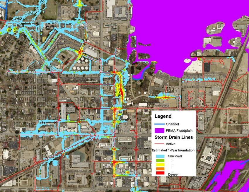
A comprehensive flood risk map would portray information on both the flood hazard (e.g., depth
and extent of flooding expected under different scenarios) and the consequences of flooding (e.g.,
building damage and population exposure). Urban flood risk maps also need to portray other information,
such as land cover, the distribution of socially vulnerable and other populations, the location of previous
flood problems, and the age, design capacity, and condition of storm water networks, drainage systems,
and roads. Geographic information systems offer one means for integrating these observations with
predictions of flood inundation.
Finding: A new generation of flood maps and visualizations that integrate predictions and local
observations of flood extent and impact is needed to communicate urban flood risk. Improved
methods for updating the maps to keep pace with urbanization and climate change are also needed.
Federal contributions for such an undertaking include flood hazard analysis (discussed above) and data on
flood damage (FEMA), precipitation and climate change (National Oceanic and Atmospheric
Administration), social vulnerability (National Science Foundation), population and demographics (U.S.
Census Bureau), and information from community development grants (Department of Housing and Urban
Development). Other contributors include public and private organizations developing visualization
techniques, especially for flood risk.
Coordination of Agencies Managing Urban Flooding
The challenges and successes of collaboration illustrated in the case studies underscore the need for
coordination among entities that manage urban flooding. Depending on the metropolitan area, more than a
dozen organizations and agency departments may be involved in urban flood preparation, response,
recovery, and mitigation. FEMA’s National Response Framework follows a tiered response approach in
which responses are handled at the lowest jurisdictional level capable of handling the problem. For major
floods, FEMA is statutorily obligated to coordinate mitigation, response, and short-term recovery
operations. However, many urban floods are too small to trigger federal resources and are managed at the
state or local level.
The coordinating structures described in the National Response Framework are intended to be
adaptable to meet the unique needs, capabilities, and circumstances of affected communities. For
example, several agencies are involved with floods in urban areas, and these agencies may include those
responsible for storm water and sewer systems or for deploying tide gauges to monitor tidal flooding and
sea level rise. These differences complicate federal, state, and local government agency coordination for
urban flooding. Nevertheless, the high concentrations of people and assets at risk add urgency for these
organizations to work together quickly and efficiently.
Finding: Stronger coordination is needed across agencies that have a role in managing small or
large urban floods. Such coordination will be both vertical (e.g., federal, state, local) and horizontal
(e.g., local agencies responsible for storm water systems, flood control, and removal of damaged
property; federal agencies responsible for severe storm warnings, evacuation, community
redevelopment, and flood mitigation in urban areas).
6
Copyright National Academy of Sciences. All rights reserved.Framing the Challenge of Urban Flooding in the United States
Summary
CONCLUDING OBSERVATIONS
Urban flooding is a complex problem that manifests across multiple dimensions. The particular
combination of physical environment, types of flood sources, and development patterns results in distinct
impacts on different urban centers and neighborhoods. Impacts vary across the social spectrum, with
vulnerable populations at higher risk, yet less protected by insurance or the social safety net. Data and
information on the causes and impacts of urban flooding are sparse, incomplete, and inconsistent.
Although it is clear that urban flooding is costly in some places (particularly in coastal cities), the shortage
of suitable data and models make it difficult to adequately quantify losses. Finally, responsibility for
managing urban flooding is distributed across federal, state, and local government agencies and
nongovernmental entities.
The current costs and impacts of urban flooding merit national attention. Further, flood problems
are likely to get worse with continued urban development and population growth in urban areas, as well as
with climate change, which is increasing sea-level rise and the frequency of heavy precipitation events.
Multiagency and cross-jurisdictional efforts are needed to analyze urban flood hazard, advance
understanding of social impacts, and communicate urban flood hazard and flood risk.
7
Copyright National Academy of Sciences. All rights reserved.Framing the Challenge of Urban Flooding in the United States
Copyright National Academy of Sciences. All rights reserved.Framing the Challenge of Urban Flooding in the United States
1
Introduction
Flooding is the natural hazard with the greatest economic and social impact on the population of
the United States. Catastrophic floods in urban areas—such as those caused by Hurricane Katrina in New
Orleans in 2005, Superstorm Sandy in New York in 2012, and Hurricane Harvey in Houston in 2017— are
seared into our nation’s memory. These floods caused significant loss of life, incurred tens of billions of
dollars in property damage, adversely affected millions of people, and damaged the economic well- being
of major metropolitan areas. Even small, frequent floods, such as those that occur during brief downpours
or high tides, can have high cumulative social and economic costs.
A critical function of the Federal Emergency Management Agency (FEMA) and other federal,
state, county, and city government agencies is to help prepare for flooding, respond to flood disasters, and
mitigate flood impacts over the long term. Central to this function are FEMA’s grants and loans
programs—which provide post-disaster financial assistance to businesses, communities, and individuals—
and its National Flood Insurance Program (NFIP), which makes federal flood insurance available in
participating communities and analyzes and maps flood hazards.
FEMA has detailed methods to quantify the likelihood and extent of flooding from riverine,
coastal, and other types of flooding. These analyses are aimed at delineating Special Flood Hazard Areas,
defined as the areas subject to inundation by a flood having a 1 percent chance of being equaled or
exceeded in any given year (also known as the 100-year flood). Within cities, however, flood damage can
occur everywhere and from more frequent, smaller floods. Such flood damage includes direct damage to
property, as well as indirect damage due to economic and social disruptions. Consequently, a perception
has developed in Congress (U.S. Congress, House, 2016) and elsewhere that urban flooding is a distinct
kind of flooding, and that its cost and consequences need particular examination. That is the focus of this
report.
WHAT IS URBAN FLOODING?
Urban flooding is the accumulation of floodwaters that result when the inflow of storm water
exceeds the capacity of a drainage system to infiltrate water into the soil or to carry it away. When a
natural landscape is transformed by urban development, its drainage pattern is disturbed. The natural
landscape, where flow gradually accumulates through small hollows and channels into local streams, is
replaced by a graded landscape where streets carry surface water flow and become an important part of
the drainage network. Storm sewer inlets drain water from the street system and convey the flow through
subsurface pipes to discharge points at downstream locations. A combination of transmission systems—
channels, streets, and pipes—conveys precipitation falling on the city to its outfall locations in larger
streams or to the coast. Floodwaters accumulating in larger streams can overwhelm the capacity of the
9
Copyright National Academy of Sciences. All rights reserved.Framing the Challenge of Urban Flooding in the United States
Framing the Challenge of Urban Flooding in the United States
stream channel and inundate surrounding areas, particularly in downstream areas that receive floodwaters
from developed areas in the upstream part of the watershed. Coastal storm surge from storm winds can
flow into coastal cities, causing direct flood damage and inhibiting drainage from inland flooding. Even in
the absence of substantial wave surge or precipitation, coastal water can encroach on urban landscapes at
high tide. Smaller, chronic floods can also occur in older cities with combined sewer systems carrying both
storm water and wastewater. These systems can become surcharged during storms, causing sewer backups
in homes and discharge of untreated wastewater into streams. Aging and inadequate drainage infrastructure
and failing pipe systems create additional flooding problems. Urban flooding poses a distinctive kind of
flood management problem for several reasons:
1. Flood problems reflect the history of a city and generally increase with urbanization. Many
early U.S. cities were established along rivers and coasts to facilitate trade, support manufacturing, and
transport people and goods. The growth of commerce and the availability of jobs and services drew
people to these early settlements, a trend that accelerated with industrialization in the mid-19th century
(Macionis and Parrillo, 2013). Hard street surfaces for motor-driven transportation became common, and
city engineers began to design and construct sewer systems to carry human waste and storm water runoff
away from homes and businesses (e.g., Figure 1.1).1 Cities began to grow outward with the help of steam-
powered trains, electric street trolleys, subways, and eventually cars.
FIGURE 1.1 Brick sewers built in Philadelphia, some of which are nearly 200 years old, are still in use today.
SOURCE: Photograph by Kimberly Paynter.
As cities grow, so do flood problems arising from the increasing fraction of impervious surfaces,
reliance on storm water systems built for yesterday’s needs, development policies, and, often, proximity
to water bodies. Land development alters natural drainage patterns that previously carried water away and
creates hardened surfaces that inhibit infiltration of storm water (Appendix A). Storm water systems built
to address these problems may be old (e.g., Figure 1.1), undersized for current needs, or poorly
maintained (e.g., leaking pipes and clogged culverts and storm drains). In addition, permissive building
practices or unenforced building or zoning ordinances have allowed dense land development in many
flood prone areas (Appendix A).
2. A large and growing number of people are affected by urban flooding, and who is affected
varies across the urban landscape. Approximately 86 percent of the U.S. population (277 million people)
lives in metropolitan and micropolitan areas, defined as core areas containing a substantial population
1
See http://www.sewerhistory.org/chronos/new_amer_roots.htm.
10
Copyright National Academy of Sciences. All rights reserved.Framing the Challenge of Urban Flooding in the United States
Introduction
nucleus, together with adjacent communities having a high degree of economic and social integration
with that core.2 In addition, population density is expected to increase in many urban areas (Appendix A).
Flood impacts across these urban areas can vary at small spatial scales, sometimes neighborhoods or even
households. And the ability of people to cope with flooding is influenced by their access to resources,
such as financial support or community networks (e.g., Figure 1.2).
FIGURE 1.2 A resident of the Chatham neighborhood of Chicago showing what she lost in the April 2013 floods.
She was attending Gross Gathering, an event convened by the Center for Neighborhood Technology (CNT) to
encourage flood survivors to speak out, share their stories, and discuss potential solutions.
SOURCE: CNT/RainReady.
3. Roles and responsibilities for urban flooding are distributed among federal, state, and local
entities. Depending on the metropolitan area, more than a dozen federal, state, and local government
agency departments, nongovernmental organizations, and private entities may be involved in urban flood
preparation, response, mitigation, and recovery. Which organizations are involved and their roles varies
across metropolitan areas.
2
Figure from the U.S. Census 2016 American Community Survey,
https://www.census.gov/data/tables/2016/demo/popest/total-metro-and-micro-statistical-areas.html. Definition from
https://www.census.gov/programs-surveys/metro-micro/about.html.
11
Copyright National Academy of Sciences. All rights reserved.Framing the Challenge of Urban Flooding in the United States
Framing the Challenge of Urban Flooding in the United States
4. Tools to analyze and portray urban flood hazard in the United States are incomplete and
inconsistent. In many cases, the default tools are FEMA maps and analyses, which were not developed to
assess urban flood hazard. For example, FEMA maps and analyses do not include some aspects of pluvial
flood hazard, flood hazard in small drainage areas (less than 1 square mile), or flood hazard created by
drainage and other urban infrastructure (FEMA, 2003).
COMMITTEE CHARGE AND APPROACH
At the request of FEMA, the National Academies of Sciences, Engineering, and Medicine
appointed a committee to hold workshops to gain an initial understanding of the causes and impacts of
urban flooding in selected metropolitan areas, and to use that information to address three tasks (see Box
1.1). The objective was to contribute to existing knowledge by providing some real-world examples in
specific places, based largely on regional workshops, and not to provide a comprehensive overview of
urban flooding in the United States. As such, the report serves as a starting point for broader and deeper
exploration.
BOX 1.1 Committee Charge
An ad hoc committee will organize a series of regional workshops or case studies to explore the issue of
urban flooding in three to eight metropolitan areas in order to gain an initial understanding of its extent and
causes in the chosen locations. These case study/information gathering sessions will provide information
from federal, state, and local government agencies, and other relevant stakeholders responsible for flood
control, flood response, recovery, or mitigation on questions related to urban flooding both outside and
inside the floodplain, such as:
How big is the problem of flooding in each metropolitan area; that is, how bad can floods be or have
floods been and how much do floods cost?
What causes the worst impacts of flooding, including structural and human impacts (human life and
property)?
How could the worst impacts be avoided or mitigated?
Who is affected most by floods in the metropolitan area?
Which regions of the metropolitan areas see the longest lasting or most costly effects of flooding?
Based on information gathered from the case study cities, the committee will produce a consensus
report that:
1. Identifies any commonalities and variances among the case study metropolitan areas in terms of
causes, adverse impacts, unexpected problems in recovery, or effective mitigation strategies, as well as key
themes of urban flooding;
2. Provides an estimate of the size or importance of flooding in those urban areas; and
3. Relates, as appropriate, causes and actions of urban flooding to existing federal resources or policies,
including but not limited to the National Flood Insurance Program, nondisaster grants, Stafford Act
authorities, or others.
Four metropolitan areas could be visited within the confines of the study, and the committee
selected Baltimore, Chicago, Houston, and Phoenix. To address Task 1, the committee gathered
information from stakeholders (government managers, academic scientists, nongovernmental
organizations, community groups, and flood victims) through workshops and meetings, site visits, and
telephone interviews in each metropolitan area. The discussions were organized around four dimensions
12
Copyright National Academy of Sciences. All rights reserved.Framing the Challenge of Urban Flooding in the United States
Introduction
of urban flooding: (1) physical—the built and natural environments, (2) social—impacts on people, (3)
actions and decision making—steps and policies for managing flooding, and (4) information—data used
to understand flood events (see Box 1.2; adapted from Linkov et al., 2013, and Fox-Lent et al., 2015).
BOX 1.2 Dimensions of Urban Flooding
Urban flooding is a multifaceted problem, comprising four dimensions defined below.
1. Physical dimensions—the natural and built environments. The natural environment includes
hydroclimatological processes that deliver rain and transport runoff through river systems, as well as land
surface characteristics (e.g., vegetation, soils, and slopes) that influence how much water can be absorbed.
The built environment includes (a) piped drainage systems that move storm water quickly away from
properties; (b) storm water detention ponds that reduce the downstream flow of floodwaters during storm
events; and (c) blue‐green infrastructure (e.g., rain gardens, bioswales, and porous paving) that emulates
natural systems of land cover, infiltration, recharge, and conveyance.
2. Social dimensions—impacts on people, which potentially includes everyone who lives or works in an
urban area. Impacts include evacuation, damage to personal or business property, business service and
supply disruptions, and the ordeal of rebuilding and recovering. The human and business impacts from floods
can vary considerably within a community, depending on the social vulnerability of its members—their
capacity to anticipate, cope with, resist, and recover from adverse impacts of flooding (Wisner et al., 2004).
3. Actions and decision‐making dimensions—steps and policies for managing urban flooding at various
scales. Examples include (a) local government policies and plans to manage flood hazard, land use and
development plans, and building codes; and (b) federal flood insurance, flood warnings, disaster relief, and
property buyouts.
4. Information dimensions—data on the three dimensions above that are used to understand or
communicate urban flooding. Examples include flood hazard analyses and maps, precipitation data, and the
capacity of piped drainage networks (physical dimension); demographics, intangible and indirect impacts of
flooding, and requests for post‐flood assistance (social dimension); and federal payouts, grants, and loans
related to flood disasters (actions and decision‐making dimension).
The workshop orientation of the study posed problems for addressing Tasks 2 and 3. In particular,
the workshop discussions did not yield enough information to estimate the size or importance of flooding in
the case study areas (Task 2). To address Task 2, the committee drew on published estimates of flood
losses in the case study areas and also analyzed federal flood loss data. Task 3—relating urban flooding
causes and actions to federal resources—is broad. The committee focused on needs that were identified in
the case studies or the committee’s loss calculations and that are strongly connected to federal resources
and policies.
ORGANIZATION OF THIS REPORT
This report explores the causes, impacts, and actions for managing urban flooding in four
metropolitan areas: Baltimore, Houston, Chicago, and Phoenix. Chapter 2 summarizes stakeholder views
of urban flooding in their metropolitan area, based on what the committee heard in workshops and field
trips (Task 1). Chapter 3 estimates the magnitude of urban flooding in the four case study areas, based on
committee analysis and published data (Task 2). Chapter 4 connects the causes and actions for managing
urban flooding with federal resources (Task 3).
Supporting material for these chapters appears in appendixes. Appendix A summarizes trends in
population, floodplain occupancy, land cover change, and climate change that influence the future
13
Copyright National Academy of Sciences. All rights reserved.Framing the Challenge of Urban Flooding in the United States
Framing the Challenge of Urban Flooding in the United States
magnitude of urban flooding. The participants and agendas for the stakeholder workshops, meetings, and
site visits in the four case study areas are summarized in Appendixes B through E. Finally, a list of
acronyms and abbreviations is given in Appendix F.
14
Copyright National Academy of Sciences. All rights reserved.Framing the Challenge of Urban Flooding in the United States
2
Insights from Four Metropolitan Areas
A major thrust of this study involved visiting different metropolitan areas to examine urban
flooding in different parts of the United States. The committee selected four places to visit: Baltimore,
Maryland, Chicago, Illinois, Houston, Texas, and Phoenix, Arizona. These metropolitan areas vary in
rainfall, growth rate, land development patterns, storm water and wastewater infrastructure, and other
characteristics that influence flooding.
This chapter addresses Task 1: identify commonalities and differences in the causes, impacts, and
recovery and/or mitigation actions across the four case study areas, based on stakeholder workshops,
follow-up interviews, site visits, or meetings with subject matter experts. Such approaches emphasize idea
generation and information exchange, rather than systematic evaluation. Discussions with stakeholders
were structured around the four dimensions of urban flooding: (1) physical (e.g., what causes urban
flooding?), (2) social (e.g., who is most affected by urban flooding?), (3) actions and decision making (e.g.,
what actions could lessen the impacts of urban flooding?), and (4) information (information needs
associated with these questions). Key messages heard in these metropolitan areas are presented below.
LOCAL REFLECTIONS FROM BALTIMORE, MARYLAND
Overview
The committee visited its first metropolitan area, Baltimore, on April 24, 2017. The visit began
with a full-day workshop that heard from local stakeholders in the morning and federal and state
stakeholders in the afternoon (See Appendix B for the Baltimore workshop participants, agenda, and list
of site visits). The committee also went on a half-day tour to see firsthand how flooding manifests in
Baltimore.
The workshop discussions focused on flooding that occurred in the city of Baltimore and that is
managed by the city’s agencies. The participants did not identify with the term urban flooding. Although
they noted that flooding occurs along Jones Falls and the low-lying areas near the harbor, the workshop
participants seemed more concerned about basement flooding and sinkholes.
15
Copyright National Academy of Sciences. All rights reserved.Framing the Challenge of Urban Flooding in the United States
Framing the Challenge of Urban Flooding in the United States
Causes of Urban Flooding in Baltimore
The Baltimore metropolitan region is subject to riverine, coastal, and flash flooding. Workshop
participants identified several contributors to flooding, including urbanization (particularly development
in floodplains), aging and insufficient capacity of storm and sewer infrastructure, subsidence and sea-
level rise, and poor building and flood mitigation practices. High concentrations of impervious surfaces
and historical flood mitigation actions (e.g., burying streams) have altered natural drainage systems in and
around Baltimore. During heavy rainfall or pluvial flood events, storm water can overwhelm the drainage
network, causing sewer backups and flooding homes and businesses. Very old storm drains that fail or
collapse are the root cause of sinkholes. Sinkholes open up across Baltimore after significant rains, creating
road closures and other inconvenient or even dangerous conditions. Sinkhole repair consumes almost all of
Baltimore’s dedicated flood management resources.1
People Affected by Urban Flooding in Baltimore
Urban flooding affects a wide array of people in the Baltimore metropolitan area. Comments from
workshop and interview participants suggest that the most vulnerable people tend to live in older, flood-
prone neighborhoods. Sustained underinvestment in water infrastructure may amplify vulnerability, and in
some places, this differential was observed along racial lines. Demographically, the elderly, poor, mentally
ill, mobility-constrained, and those with limited experience of flooding were consistently identified as
among the most susceptible to flooding effects in the city. Feedback from Baltimore participants also
indicated that noncitizens and undocumented immigrants have higher vulnerability due
to restricted access to government services, fear of their undocumented status being exposed, and a
general lack of trust in officials.
The workshop discussions revealed passions about services available for disenfranchised
Baltimoreans. Flooding interrupts service provision at the most basic levels: access to food distribution
centers, schools or child care facilities, and regular health services (e.g., dialysis or methadone),
especially for low-income residents. Flooded health clinics and mold in schools were named as problems
related to flood events, and frustrations ran high about closed or limited access to the facilities that serve
Baltimore’s neediest residents. Several respondents commented that 311 calls to report flooding are
depressed in socially vulnerable areas due to fear that making calls will result in governmental corrective
action unrelated to flooding.
The concerns of the disenfranchised stood in stark contrast to risky development decisions in
more affluent neighborhoods. In a new residential complex constructed along the Jones Falls system, for
example, floods can reach the second-floor windows (Figure 2.1, left). A bridge from the building’s
second level was built to enable egress during severe floods (Figure 2.1, right). In addition, residents of
valuable historic properties, which are in the flood channel and flood repeatedly, receive subsidized
National Flood Insurance Program (NFIP) flood insurance because of the historic status of the buildings.
1
In-person tour with employees of the City of Baltimore Department of Public Works, April 2017.
16
Copyright National Academy of Sciences. All rights reserved.Framing the Challenge of Urban Flooding in the United States
Insights from Four Metropolitan Areas
FIGURE 2.1 (Left) Image of newly renovated apartments inside a historic building. Rivets (circled in yellow)
between the first and second floor windows mark the flood stage for this building. (Right) Image of newly renovated
apartment building that includes an escape bridge on the second floor for safe egress during flooding.
SOURCE: Photo courtesy of Lauren Alexander Augustine, National Academies of Sciences, Engineering, and
Medicine.
Actions
Flood mitigation, management, and recovery are managed by Baltimore’s Department of Public
Works. At the time of the committee’s visit, the department had no dedicated budget for flooding in the
city. In contrast, Baltimore works closely on water quality improvements with and through the
Environmental Protection Agency (EPA) and its Chesapeake Bay Program. Resources from EPA and
others for water quality improvements are a major driver for capital investments in Baltimore. Workshop
participants commented repeatedly about the misalignment of available flood and sinkhole resources and
the needs for flood management in Baltimore.
Workshop participants provided numerous suggestions for reducing the adverse impacts of
flooding in Baltimore. Many recommended greater participation and influence of local residents on
infrastructure investment and disaster recovery decisions. Stakeholders also noted the importance of
investing in both the maintenance of and upgrades to the storm water and sanitary sewer systems. Finally,
getting ahead of the city’s sinkhole problem would avoid transportation disruptions and resource diversions
from proactive mitigation.
LOCAL REFLECTIONS FROM HOUSTON, TEXAS
Overview
The Houston metropolitan area, which includes Harris County, is among the most flood-impacted
urban centers in the nation. The catastrophic events of Hurricane Harvey focused national attention on
Houston in August 2017 (See Box 2.1). However, area residents have lived with floodwaters for
generations.
17
Copyright National Academy of Sciences. All rights reserved.You can also read