A resource for research and teaching. The Online Portal of the Historical Dictionary of Italian Cartographers
←
→
Page content transcription
If your browser does not render page correctly, please read the page content below
J-READING
JOURNAL OF RESEARCH AND DIDACTICS IN GEOGRAPHY
1, 9, June, 2020, pp. 27-43                                                          DOI: 10.4458/3099-03

A resource for research and teaching. The Online Portal of
    the Historical Dictionary of Italian Cartographers
Annalisa D’Ascenzoa
a
 Dipartimento di Studi umanistici, Roma Tre University, Rome, Italy
Email: annalisa.dascenzo@uniroma3.it

Received: November 2019 – Accepted: April 2020

                                                 Abstract
The COFIN national project Studi e ricerche per un Dizionario storico dei cartografi italiani (Studies and
researches for a historical dictionary of Italian cartographers) brought together, at the start of the 2000s,
fourteen research units and a large group of scholars to prepare bio-bibliographical dossiers on the figures
of those Italians (or non-Italians who had worked for many years in Italy) who had produced cartography.
The mass of material then collected and sent to the organizers remained largely unpublished or published in
different places, without a clear link for the general public. Recently a group of researchers at Rome Tre
University have taken this material in hand and instigated its incorporation onto a portal, thus creating an
open access, digital depository, organized in Italian and English, and accessible for consultation of its bio-
bibliographical entries. The plan behind the portal, Digital DISCI, is the stimulation of research on Italian
cartography and the cartographers of our country, but is envisaged as widening the research field to Europe
and the rest of the world. The realization of several of the identified objectives depends upon making the
project known to the scholarly and educational world. The work of university teachers and students can be
a valuable means of spreading information locally and of increasing awareness.

Keywords: Biography, Cartographers, Cartography, Dictionary, Digitalization, Dossiers, Portal

                 1. Introduction                         storico dei cartografi italiani (Studies and
                                                         researches for a historical dictionary of Italian
   Between 2017 and 2019 a small group of                cartographers). This project, known by the
university teachers and students from Roma Tre           acronym DISCI (Dizionario storico dei
University, in partnership with the Centro Ital-         cartografi italiani), had received funding in the
iano per gli Studi Storico-Geografici (Italian           period from 2003 to 2005 when the national
Centre for Geo-Historical Studies), worked to            research group, coordinated by Ilaria Luzzana
recover the material which had been sent, years          Caraci, then on the faculty of geography at
before, to the central unit of the COFIN national        Roma Tre University, and with the support of
project Studi e ricerche per un Dizionario               Claudio Cerreti, was made up of fourteen local

Copyright© Nuova Cultura                                               Italian Association of Geography Teachers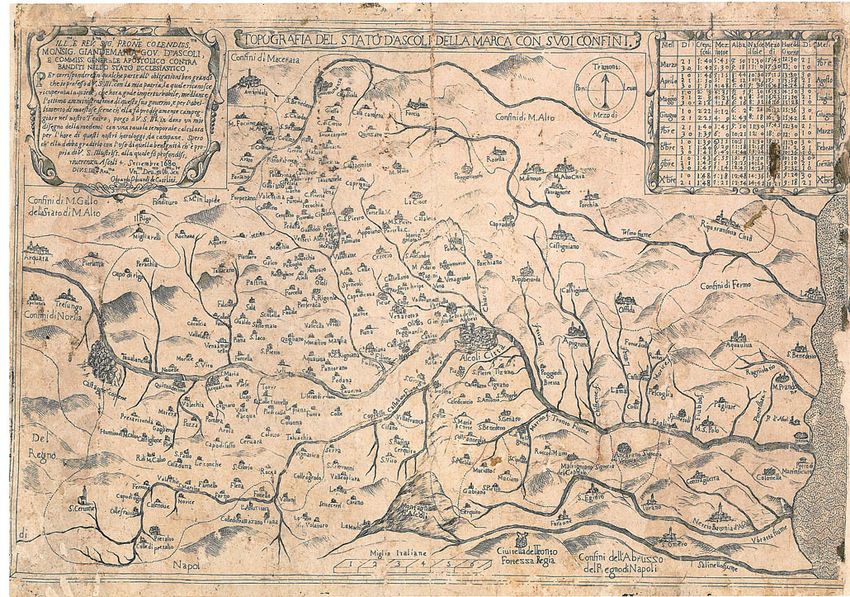
28                                             Annalisa D’Ascenzo

units spread throughout Italy. Each of these units            From a scientific viewpoint, internationally,
brought together a number of shorter-term staff,          DISCI was an ambitious and innovative program
associates, and contracted researchers to carry           to carry out a vast research project on all the
the research forward: over 150 officially                 figures of Italians (or non-Italians who had
recognized individuals were thus involved, to             worked for many years in Italy) who, in various
which should be added other young researchers1.           capacities, took part in the production of
    In the 20th century fundamental works were            geographical maps and charts. The temporal arc
published on the history of cartography and               under consideration, in the end, basically
historical cartography which indicated the need           extends from the fifteenth to the nineteenth
for     biographical    information      on    the        century.
cartographers, for example, the series of the                 This was the realization of an idea
Monumenta Cartographica launched by                       germinated some years earlier, which brought
Almagià, in which biographical details were               together the perceived scientific needs of those
added to the historical-descriptive files that            working on historical cartography and the
accompanied the iconographic and cartographic             history of map-making. A project was born with
reproductions (Almagià, 1929, 1944-1955)2.                the intention of filling a void, particularly in our
Among these reproductive works the Portugali-             knowledge of those figures defined as “minor”,
ae Monumenta Cartographica (Cortesao and                  not actually of the second level necessarily, but
Teixera da Mota, 1960; ed. facsimile, English             who nevertheless had until now received less
and Portuguese, 1987) stands out: a collection of         attention from scholars (Cerreti and Taberini,
entries on the authors of the maps presented, or-         2001). The repertoires then available were few,
dered alphabetically and chronologically, with            unsystematic and lacking on the lesser known
specific “elementos biográficos”. In terms of             figures. Naturally the project had no intention of
proper dictionaries, the best known was and is            ignoring the “great” cartographers, for whom
Tooley’s Dictionary of Mapmakers, with the                exhaustive dossiers were to be compiled, but
number of entries increased in the revised edi-           limited in their size by making reference to the
tion (Tooley, 1979-1985; Tooley et al., 1999-             informative       and      specialist     published
20043). Another very well known reference                 monographs already existing.
work is The Mapping of the World with entries                 All cartographic authors seemed to be
ordered chronologically and alphabetically by             fundamental for building a full and more
author (Shirley, 1984, 2001).                             accurate picture of the history of cartography,
    None of these works, however, pay systemat-           principally Italian but not solely because of the
ic attention to the wide range of individuals who         exchange-of people, techniques, and materials-
brought about the realization of cartography.             which took place with other countries of the
                                                          world. Even the very concept of cartography
                                                          was meant in a broader sense, taking in a range
1
  For more details on the composition of the national     of objects from manuscripts to printed materials,
group, local units and their distribution, names of the   geographical or thematic, or even closer to
participants,     see     the    page      Researchers,   iconography, terrestrial or nautical, survey or
https://www.digitaldisci.it/researchers/.                 administrative, relating to Italy or her colonies.
2
  Although with different characteristics, there are
many possible examples of these national projects:            We shall not dwell further on the genesis and
Kamal, 1926-1951; Svambera et al., 1938; Schilder,        earlier findings of DISCI, but move to the work
1986-2013. In terms of nation states: Germany:            then carried out on these findings in the last
Bonacker, 1966. Great Britain: Steer and Eden, 1975-      years and more recently (Cerreti, 2003, 2009a;
1976; Worms and Baynton-Williams, 2011. France:           D’Ascenzo, 2018). One final focus, however, on
Pedley, 1992; Pelletier, 1996. Spain: Cámara Muñoz,       those aspects linked to education, which were
2005 and 2016; Sanchez Rubio et al., 2014. Nether-        important from the very start of the project. The
lands: Pflederer, 2012. Italy: Valerio, 1993.             teachers, who gave classes in the course of
3
  The latter Dictionary contains about twenty thou-
                                                          training and updating for the young researchers
sand cartographers, engravers and publishers active
from the earliest times until 1900. Both versions are     involved in the project, bore in mind the
currently available only in paper format.                 question of the theoretical and practical bases

Copyright© Nuova Cultura                                                Italian Association of Geography Teachers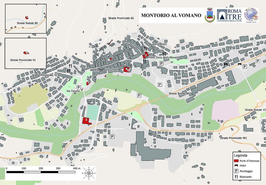
Annalisa D’Ascenzo                                             29

the students needed to carry the work forward        present writer, because taking this material in
(see the special number of the Geostorie journal     hand was clearly complicated, given the time
which brings together the texts of the operations:   that had passed. But the dossiers collected and
D’Ascenzo, 2004). Some of them, for example,         stored in a cupboard in the “Giuseppe Caraci”
provided the cognitive tools needed to tackle        Laboratory of Roma Tre University were of
research on particular types of map, or              enormous value. The information was already
illustrated the new possibilities for study and      there, an enormous challenge had been met, and
restoration work introduced by technology            could be capitalized on by using the most
(Conti, 2004; Federzoni, 2004a, 2004b).              appropriate current information technology
                                                     tools. Favourable circumstances (a grant from
                                                     the Department of Human Studies), and a good
                                                     dose of obstinacy combined with a strong
   2. The sources and dossiers of DISCI              personal obligation, led to the launch of the
    The starting point for DISCI were the            online portal. As stated above, the main aim of
existing         publications        (monographs,    Digital DISCI is that of giving new visibility to
encyclopedias, papers, articles in journals)         the work already carried out by so many
together with the iconographic and cartographic      researchers and making available the online
materials produced in past centuries, which          depository which, in the field of geo-historical
underwent appropriate research to discover the       studies, is seen as increasingly important. A
names of those who had produced them and any         good beginning in sight for the realization of the
available biographical details. As an example,       “Tooley italiano” (Cerreti, 2003, p. 18).
we have the maps of the Alexandrian and
Gregorian Cadastes, outstanding sources from
which to extrapolate long lists of the                      3. The Digital DISCI portal. New
professionals working in fiscal enquiries and              frontiers for research and teaching
land registry operations over vast territories.
    The most innovative and demanding part of            Digital DISCI, the portal that brings together
the DISCI project was the next. As the research      the dossiers produced in its time for the Studies
continued in archives, libraries and record          and researches for a historical dictionary of
offices it triggered the work of analysis and        Italian cartographers is an open access, digital
study of the sources which was in turn to            depository, organized in Italian and English, and
produce a long list of results: over 60 titles       accessible for consultation of its bio-
among monographs, collected volumes, papers,         bibliographical entries. All the entries contained,
articles, etc. (some examples: Polto, 2006;          both those unpublished and those already
Quaini and Rossi, 2007; Valerio, 2007). The          published elsewhere, have been given ISBN
large series of publications from the individual     numbers (given that they now appear in a new
local bodies, often responding to diverse            format, as electronic publications).
publishing directions, represents, however, only         To place the scientific value of DISCI and its
one part of the research results. A great mass of    return as Digital DISCI in context, we need to
material, for differing reasons, still awaited a     observe that there is no other project known
definitive version and place of publication.         internationally that is similar in its breadth and
    From these brief indications and the objective   depth, in spite of the limits mentioned as to the
difficulties of the research, it is clear why the    research studies carried out, let alone available
files uploaded onto the DISCI portal are so          online. There are interesting and rich collections
heterogeneous and varied.                            of maps4, which give information on the authors,
    The complexity of the material, the boldness
of the project, the sheer quantity of results        4
                                                       Just as an example, as a support for teachers, we
reached over a long period, have posed concrete      mention some portal: Europeana, Gallica, Library of
problems of management for the central unit          Congress, Portal de Archivos Españoles (PARES)
which actually held the physical dossiers sent to    and Catálogo colectivo de la red de Bibliotecas de los
it. Those same concerns have motivated the           Archivos estatales.

Copyright© Nuova Cultura                                           Italian Association of Geography Teachers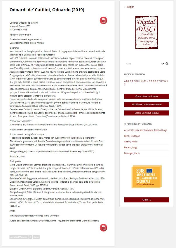
30                                             Annalisa D’Ascenzo

but no ample biographical dictionaries and no              and educational undertakings of ever greater
open access5. A digital dictionary, freely                 dimensions.
available on the net and bilingual, combines the               An example in this sense is the entry already
scientific knowledge with accessibility to the             present on the military engineer “Odoardi de’
collected materials.                                       Catilini, Odoardo” written by Giorgio Mangani
    The system has the advantage of being                  (Figure 1). Recent research has produced new
continuously implemented: it is open to receive            information, which has led to the upgrading and
further materials that escaped attention, or               expansion of the entry (D’Ascenzo, 2019)
dossiers produced after the early years of this            (Figure 2).
century and more recently6.                                    Thirdly, the case of bringing about new
    The progressive, and voluntary, inclusion of           dossiers on cartographers as yet unknown. There
new files by the authors (both those who are part          must be a treasure trove of names and
of DISCI and those from outside) will allow                information waiting to emerge from the various
continuous updating of the database, an                    Italian and European record offices, or which
important operation in at least three ways: those          simply need to be put into the system and online
cartographers who have already been fully                  (Cámara Muñoz, 2005, 2016).
recorded, around 1,000, can be entered as an                   The groundwork towards this has already
updated/expanded draft or in a new version (as             been laid (D’Ascenzo, 2017). A project is
happens with the Dizionario Biografico degli               currently being drawn up to form an Italian-
Italiani – Biographical Dictionary of Italians).           Spanish working party. The experiment will
For the other, over 6,000, Italian cartographers           engage the present writer with the researchers
known only by name and with few details,                   who in the last years have worked and written
further information will give body and substance           much upon the Italian engineers transferred to
to the research, so placing at the disposition of          Spain in the course of the seventeenth century.
the academic community and of society as a                 These were military personnel called upon to
whole-obviously including the world of
                                                           work on the defence campaigns in frontier
education-a source which will enable cultural
                                                           strongholds and to map the borders engaged in
5                                                          warfare in the Iberian Peninsula and the Spanish
  Although chronologically and thematically limited,
an example close to Digital DISCI appears the list of      Empire. The iconic figure in this situation is the
975 “oficiales del Real Cuerpo de Ingenieros del           Tuscan Lorenzo Possi who, between 1665 and
siglo XVIII”: http://www.altorres.synology.me/01_          1677 or thereabouts, under Philip IV and
06_siglo18.htm. Although the list is extensive, fewer      Charles II of Spain, served in the monarchy’s
than 40 military engineers have a biographical fact        army in the battles being fought on its European
sheet available on the Web.                                and North African frontiers (Sánchez Rubio et
6
  The setting of the project, at the moment, is clearly    al., 2014). Biographical information and
linked to the field of university education and            references to much other material (maps,
teaching; in fact it requires bibliographic and archival   reports, various documents) on Possi that have
research. But we think that the portal can provide
                                                           been found in numerous record offices will be
future teachers in training with materials and ideas
that can be used in their lessons. The personal history
                                                           extrapolated to build dossiers on the group of
of a cartographer and the products made by him tell        Italian soldiers who worked with the Tuscan in
of the era in which he lived and the territory he ob-      his years of service outside Italy.
served, with the characteristics of the time. The
teachers, together with their students, can look in lo-
cal libraries and archives for maps of their area and
can obtain digital reproductions. They can also carry
out investigations into the authors of the maps, at
least identifying their names and the years in which
they were active. After having worked on the maps in
class, analysing their contents, they can send their
files and digital images to the site editors. These ma-
terials could feed into the Digital DISCI, possibly
even in a new section dedicated to schools and educa-
tional projects.

Copyright© Nuova Cultura                                                 Italian Association of Geography Teachers
Annalisa D’Ascenzo                                              31

Figure 1. The entry on “Odoardo Odoardi de’ Catilini” in Digital DISCI by Giorgio Mangani (Local unit of
Chieti). Source: http://www.digitaldisci.it/odoardo-odoardi-de-catilini/.

Figure 2. The new entry (2019) on “Odoardo Odoardi de’ Catilini” in Digital DISCI by Annalisa D’Ascenzo
(Local unit of Roma Tre). Source: http://www.digitaldisci.it/odoardi-de-catilini-odoardo-2019/.

Copyright© Nuova Cultura                                            Italian Association of Geography Teachers
32 Annalisa D’Ascenzo
A further example is that of another military to the cartography of the state (Rombai, 2003)
engineer, Carlo Antonio Biancone, author of a (Figure 3)8.
small fund of maps of the territory of Teramo,
and of Montorio al Vomano in particular, kept in
the Archivo General de Simancas. These maps
are extremely valuable for the study of the
socio-economic situation on the border between
the Kingdom of Naples, a constituent kingdom
of the Spanish monarchy, and the Marche, which
was part of the State of the Church (the Papal
State) at the end of the seventeenth century
(D’Ascenzo, 2013, 2019)7. The collection has as
its object the banditry rooted in the mountains of
the Abruzzi and particularly in the high valley of
Vomano, between Montagna di Roseto, the
Valley of San Giovanni and the Castellana
Valley. Although Biancone was already known,
along with other Italians whose work is held in
the Spanish record office (Principe, 1982), he
did not yet have a dedicated dossier.
All these new entries need to be built
following the approach and structure of the
DISCI files, the shared fruit of a long and
complex work of standardization and
identification of unavoidable fields. Nor are
those files representing the summarised revision
of more ample work on individual authors (cited
in the bibliography) excluded.
Equally clearly, apart from entries on actual
people, Digital DISCI collects and will continue
to collect items on the bodies that produced
cartography, whose cultural and educational
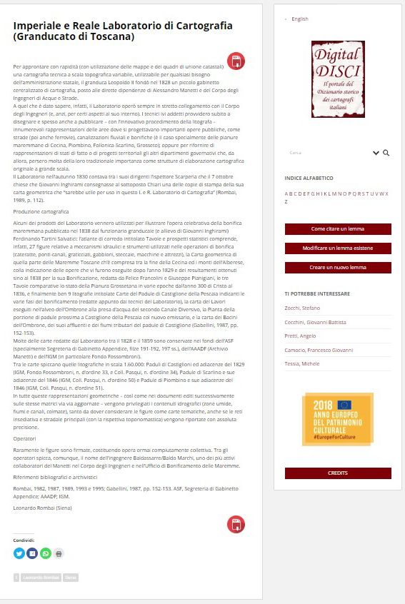
value has been excellently outlined by Leonardo Figure 3. Entry on “Imperiale e Reale Laboratorio di
Rombai in his article detailing the history of the Cartografia (Granducato di Toscana)” by Leonardo
foundation of the collective technical bodies Rombai (Local unit of Siena).
(institutional offices and magistratures) within Source: http://www.digitaldisci.it/imperiale-e-reale-
the bureaucratic administration of the old Italian laboratorio-di-cartografia/.
states, from the mid-fifteenth century up to the
eighteenth and nineteenth century geometric
cadastres, ranging from cartographic businesses Every school could carry out research on local
corporate bodies which, over a long period, have
been important in the management of our
country’s territory: the administration of
7
We are dealing here with pictures of the past, drawn infrastructure and of assets both physical (roads,
in great detail and with attention to the aesthetics, canals and embankments, bridges, fortifications,
which enable us to see, over and above the obvious factories) and commercial (customs), of resources
contents, the space lived in by and organized with a (water), of great estates (principalities, the Tuscan
view to its possibilities (economic, technical etc.) and Presidi), land private and public (communities,
the needs of the moment. Banditry was an ancient
phenomenon against which the viceroy Don Gaspar
8
de Haro y Gúzman (1683-1687), marquis of the Car- For informations on collective public entities see
pio, intended to wage a hard and radical war. also Manzi, 2006.
Copyright© Nuova Cultura Italian Association of Geography Teachers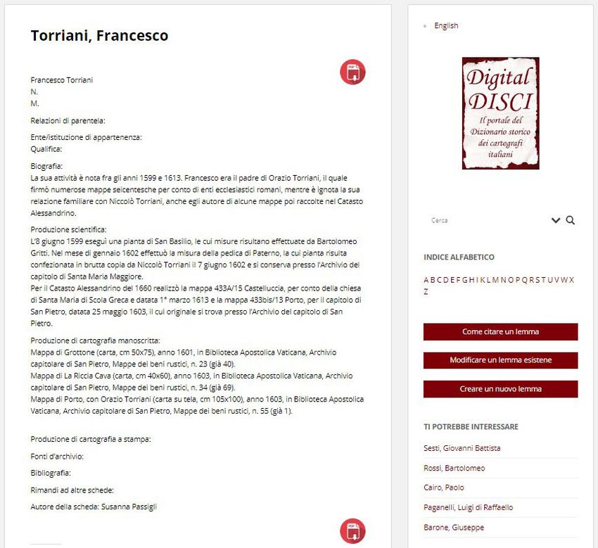
Annalisa D’Ascenzo                                               33

municipalities, woods), controllers of surveys        and record offices throughout the national
(cadastres and land registries, boundaries, rents,    territory and beyond.
cultivation), lay or ecclesiastical congregations,
consortiums, workshops, civil or military orders.         One example of a cartographic production
                                                      already loaded onto the Digital DISCI portal is
                                                      the Topografia del Stato d’Ascoli della Marca
                                                      con suoi confini (1680) of Odoardo Odoardi de’
       4. Envisaged implementations                   Catilini, cited above, which is interesting for
                                                      various reasons, among which is its picture of
    A record of DISCI’s published productions is      the boundary between the Pontificate State and
in preparation, but it will only be possible to       the Kingdom of Naples at the end of the
have satisfactory results with authors’               seventeenth century (Branchetti, 2014, pp. 163-
contributions. If they are prepared to share the      164) (Figure 4).
list of their publications, an updated picture will
emerge of the many research works carried out
and published to date. At present, those directly
involved in checking the materials have been the
representatives of the local DISCI units, but an
attempt will shortly be made to contact known
researchers as well.
    Scrutiny of the files will also lead to the
availability of a bibliography, exhaustive if not
fully complete, which will be of great value, as a
summation of the texts cited in each entry. The
educational value of such a tool is obvious, for
carrying out further research work, which could
be particularly suited to graduate, master or
doctoral dissertations. Work of this sort will        Figure 4. Odoardo Odoardi de’ Catilini, Topografia
most certainly feed into the Digital dictionary of    del Stato d’Ascoli della Marca con suoi confini
historical Italian cartographers.                     (1680), dedicata a Monsignor Giandemaria governa-
                                                      tore di Ascoli e Commissario generale Apostolico
   A further section of the portal, already           contra banditi nello Stato Ecclesiastico. [Topography
designed, will take account of Italian                of the State of Ascoli della Marca with its boundaries
cartographers’ iconographic materials and             (1680), dedicated to Monsignor Giandemaria, Gover-
cartographic    productions     already   found       nor of Ascoli and Apostolic General Commissioner
elsewhere online. The links to digitalized            in the Ecclesiastical State against outlaws.] Printed
documents from national or foreign record             etching9.
offices will be collected and supplied so that
users can see this material. This part of the
overall project, which aims to be a reference                      5. University teaching
resource for students of cartography and the
                                                          In the preceding section a series of
history of cartography, will also be open to the
                                                      approaches were listed that have already been
partnership of those who wish to add their own
                                                      followed to feed into the Digital dictionary of
contributions. More importantly, we suggest that
                                                      historical Italian cartographers.
such research could be suggested to students
enrolled in university courses, while the very
nature of research on the Web also makes it           9
                                                            https://it.wikipedia.org/wiki/File:11_-_Topografia_
suitable for groups of younger pupils or              Del_Stato_D%27Ascoli_Della_Marca_Con_Suoi_Conf
individuals, who, up to the end of compulsory         ini,_1680_Odoardo_Odoardi_de%27_Catilini.jpg.
schooling (in the medie superiori), could report      Other examples: Archivio di Stato Roma, CDM, I,
on the digital reproductions found in archives        cart. 6, n. 247.; Istituto Geografico Militare,
                                                      http://www.igmi.org/ancient/scheda.php?cod=13040.

Copyright© Nuova Cultura                                             Italian Association of Geography Teachers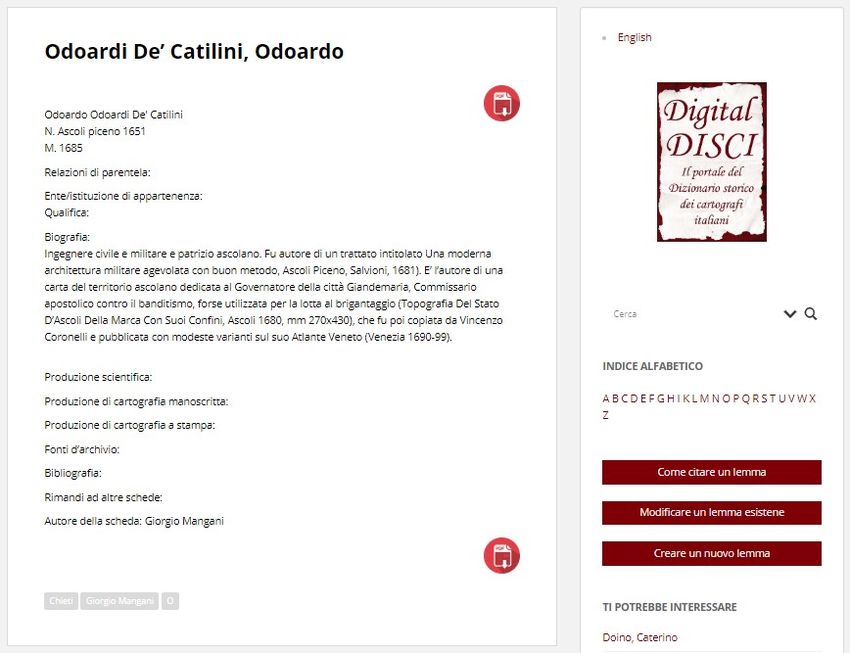
34 Annalisa D’Ascenzo
Until now, given that the portal has only find in historical cartography a solid support for
recently gone online, the possibilities of using helping students to understand the evolution of
the materials for teaching have been limited to a the techniques and the continuance of require-
few known cases, all, at present, in the context ments that the map reveals and conserves. Fur-
of the academic world. thermore, the teachings want to show over and
In the academic year 2018-2019, for above its fundamental role (or rather necessity)
example, a group of students from Roma Tre in the knowledge, organization and administra-
University, enrolled in the workshop “GIS for tion of the territory. As we have learnt, as well
cultural heritage” in their course of study in as their value in confirming earlier territorial as-
historical sciences and international cooperation, sets, maps add evidence of the mentality and
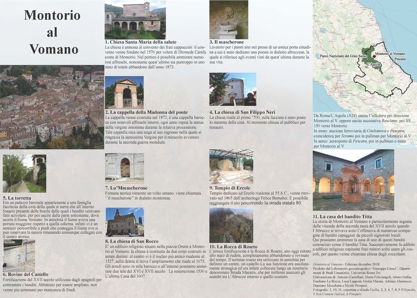
worked on Montorio al Vomano. Our colleague cultural footprint of society of the past (for the
Arturo Gallia structured a proportion of the cultural and applicative aspects of the most re-
classes around the study and evaluation of the cent geo-historical studies we cite for example:
outstanding historical cartography which smaller Dai Prà, 2018; Dai Prà and Alaimo, 2013; Dai
towns can lay claim to in the regional picture. Of Prà et al., 2018; Mastronunzio and Dai Prà,
all the illustrations gathered, those of the 2017).
greatest value are certainly the maps and plans The courses mentioned above are offered at
drawn up by the known military engineer Carlo all levels of the teaching programme: from the
Antonio Biancone, which depict, in great detail, workshops cited to curricular courses for both
the country at the end of the seventeenth century the three year degree course and the master’s
(D’Ascenzo, 2010, 2013). Elements of the urban course. For doctorates11 there are the doctoral
fabric, today lost or forgotten (walls, gates, seminars organized by the geographical histori-
fountains), emerge from the historical maps and ans attached to the Faculty for those enrolled in
restore a memory of places lost over the course the various on-going courses12, in addition to the
of the last three centuries. Such elements, annual seminars, “Dalla mappa al GIS” (From
together with those places currently important the map to GIS)13, which centre on cartograph-
for its present population, have been analysed ical documentation, historical and current, and
and restored in a tourist map by the participants the epistemological and theoretical thinking on
in the workshop (Figures 5 and 6). The students use of the instruments of geographical enquiry in
were able, after a field trip on site, to evaluate analysis of the relationships between people and
the changes which the ancient town had territory. On the latter we have, for many years
undergone and the town’s current problems (not now, benefited from the active participation of
least the damage caused by the earthquake of our colleagues from the Capitoline Superintend-
2009, still visible today) experienced by its ency of Cultural Heritage, Directorate of opera-
inhabitants. The students could therefore tions on monumental buildings.
propose those items from the town’s natural and
cultural heritage which would be of interest to
visitors wishing to learn of the geo-history of
Montorio and its identity in the modern age.
11
The Alexandrian and Gregorian Cadastres are Doctorate in “History, territory, cultural heritage”
often used by a group of historical geographers earlier entitled “History (Politics, Social Culture, Ter-
ritory)”.
from Roma Tre both as the starting point for his- 12
In March 2019 the Doctoral Seminar of Geography
torical-geographic research, in particular on the hosted a series of lectures by Gianluca Casagrande
region of Roma (Master’s thesis), and also in (European University of Rome), “Low-cost technolo-
their classes10. There are several courses which gy for the recognition and documentation of minor
landmarks”, and by Nicola Gabellieri (University of
10
On the multiple importance of the Cadestre and ar- Trento), “A historical-geographical approach to inte-
chive sources we cite we cite the collective volumes grated sources through the study of rural landscapes:
edited by Gallia (2016) and Carallo (2017), which the case-study of Val Bisagno between abandonment
collect the results of the Seminars Dalla mappa al and hydro-geological vulnerability”.
13
GIS: http://www.labgeocaraci.it/category/ The list of publications is available at the link on
pubblicazioni/mappagis/. See also Sinisi, 2014. note 10.
Copyright© Nuova Cultura Italian Association of Geography TeachersAnnalisa D’Ascenzo 35 Figures 5 and 6. The project of a tourist map on Montorio al Vomano (2018). Produced by the “Giuseppe Cara- ci” geocartographic Laboratory, Department of Humanities, Roma Tre University. Elaboration of: Antonio Ca- stellani, Marta Feliciangeli, Arturo Gallia, Emiliano La Rocca, Luca Lapponi, Giulia Marani, Adriano Marinuc- ci, Damiano Moschetta and Nicolò Prosperi. Copyright© Nuova Cultura Italian Association of Geography Teachers
36                                             Annalisa D’Ascenzo

    As regards the Master’s degree, for some
years this has combined lectures14 with further
study wherever original materials have been pre-
served: of particular importance is collaboration
with the Roman archives, including, thanks to
the directors, the State Archive. In the central
locality, Sant’Ivo alla Sapienza, and in that at
Galla Placidia, series of theoretical and practical
classes are held15.
    On the subject of teaching, attention must be
drawn to the in-depth analysis of original mate-
rials carried out in the State Archives by Susan-
na Passigli. In an article she emphasises the im-
portance of work on the inventory of the archive
offices of the Trenta Notai Capitolini preserved
in the Archive of the State of Rome (Verdi,
2009) as a contribution to the inventory of the
older plans of the agricultural hamlets of the
Agro Romani drawn up by Jean Coste (Coste,
1969, 1973). Passigli points out the cultural and
didactic value of such research on the maps of
these hamlets linked to notarial deeds in the
modern age, which she uses in her university
teaching16 (Passigli, 2018).
    To underscore further the value of these geo-
historical studies, we should not forget that we
owe to Susanna Passigli the many files uploaded
onto Digital DISCI on the ‘land-surveys’ includ-
ed in the Alexandrian Cadastre (Figure 7). The
many entries, on the other hand, on the ‘cartog-
rapher’ authors of the maps of the Gregorian
Cadastre (Figure 8) are thanks to Adriano Rug-
geri17.

14
   Interdepartmental Master at level II in “Digital       Figures 7 and 8. Examples of entries on cartographers
Earth and Smart Governance. Strategies and GIS            working on the preparation of the “Catasto alessan-
tools for the management of territorial and cultural      drino” and the “Catasto gregoriano” by Susanna Passig-
heritage”. We highlight particularly the modules          li and Adriano Ruggeri (Local unit of Roma Tre).
“Cartography and historic-environmental analysis” 1       Sources: http://www.digitaldisci.it/francesco-torriani/;
and 2 (taught by Carla Masetti and Annalisa               http://www.digitaldisci.it/magoni-giovanni-maria/.
D’Ascenzo, M-GGR/01).
15
   Thanks are due to Doctor Luisa Falchi, a splendid
and enthusiastic scholar and guide through the mar-
vellous original materials and in the fields of docu-
ment conservation.
16
   Storia della città e del territorio (M-STO/02) [His-
tory of the city and territory].
17
    Researchers with extensive archival research
experience (Passigli and Ruggeri, 2014).

Copyright© Nuova Cultura                                                 Italian Association of Geography Teachers
Annalisa D’Ascenzo 37
6. New developments. The Digital researchers attentive to the world of school
dictionary of historical Italian (Seimplatton, 2013, 2019).
cartographers in schools In our opinion, historical-geographical
documentation and historical cartography have
As in the preceding section, this section
enormous communicative value. In general are
reports a number of future projects which have
drawn in stages and with intelligible symbols,
been considered. These revolve in particular
not too technical or complicated, which can
around the school world, or rather, and better, to
therefore be read and understood with a
the teaching of geography to the teachers of the
minimum of preparation. They can be drawn by
future.
hand – the ease of graphic rendering, with a
The group of teachers promoting the research range of colours, which appeals to so many
for DISCI and Digital DISCI have direct young. They can take various formats, from the
knowledge, through their own teaching more manageable “cabreos” maps of private
experience, particularly at universities, of the properties, right up to the great cadastres, and
success of historical-geographical have therefore the ability to strike the
documentation and historical cartography in imagination and remain in the memory.
capturing the attention and curiosity of the
Although we have not had wide educational
young. In addition to the educational success
experience with children and adolescents, we
among students of the humanities and courses
know that comparison with the maps of the past
for future teachers, we have been encouraged by
helps younger people to understand the two
the positive experiences recorded on public
fundamental dimensions of time and space. To
occasions of meeting younger boys and girls.
understand how the shape and dimensions of the
For example, those who are enrolled at
globe has been pictured and measured, from
secondary schools and attend meetings for
ancient times to modern times and to our present
prospective college or university students, or the
day. How and why, for what erasons, knowledge
children who take part in extra-curricular events
of the planet or of its many parts has been
(GeoNight, exhibitions, seminars). There is
modified and increased over the centuries. How
actually little bibliography on such educational
the cultural context is important to reconstruct
projecyts; it is a frontier still to be explored. We
ancient knowledge, to understand the
note, however, that the theme of using historical
relationship with others and with diversity,
cartography for educational purposes has been
people’s fears. The concept of borders. How
discussed in Spain (León Guerrero, 2011, 2019).
much near and far depends on technology and
Not surprisingly, Italy and Spain are two
the means of communication. The basic
countries with a great tradition of historical-
explanations are already all there for the most
cartographical studies and an abundance of
ancient representations of the oecumene (the
archive material18. The launch of a speech in this
known world), the mediaeval and modern
direction was addressed in the summer courses
planispheres, the atlases and chorographies (De
of the Petrus Apianus' Academy, open to the
Vecchis and Morri, 2010, pp. 54-57, 102-109).
international participation of teachers and
In this first phase of the project we hope first
of all to make the depth and validity of historical
18
In corroboration of the didactic use of this docu- cartographic sources clear to all teachers,
mentation, we can cite the exhibitions Cartografías together with the many analytical connections
de lo desconocido. Mapas en la BNE (Madrid, 2017- that they allow to be drawn between the
2018) and Quand les artistes dessinaient les cartes. disciplines: geography, history, literature,
Vues et figures de l’espace francais Moyen Age et economics, politics, history of religion etc. The
Renaissance (Paris, 2019-2020). A recent Italian pro- question of teaching how to teach remains open.
ject which supports the educational value of such ma- As Lévy wrote, with reference to France but the
terials is the work-group AGeI “Musei di Geografia: argument applies equally to Italy:
organizzazione della conoscenza, valorizzazione e
divulgazione del patrimonio geografico accademico”
(GEOMUSE; https://www.ageiweb.it/gruppi-di-
lavoro/geomuse/).
Copyright© Nuova Cultura Italian Association of Geography Teachers38 Annalisa D’Ascenzo
Siamo ancora lontani da una formazione find an early historical foundation in the
all’analisi di un oggetto grafico come realtà Alexandrian Cadastre map of 160020.
globale… Per gli attori del sistema educativo,
la posta in gioco consiste, nel contempo, nel
Such evidence opens up the possibility of the
mantenersi quanto più sensibili è possibile “casually” appearing lake entering the realm of
all’ascolto delle innovazioni e a considerarsi history and can support-through the testimony of
responsabili della costruzione negli allievi di the past-its previous existence, the recovery of
competenze aperte alle esperienze future. In- memory, its identity, the ability to protect the
segnare la carta è anche imparare ad impara- basin and surrounding area. Territorialization, just
re, per rendere possibili gli apprendimenti al- as narration and illustration, can find support and
la lettura e anche alla concezione delle carte, i furtherance in historical cartography. “Social
cui principi non esistono ancora (Lévy, 2007, energy” can benefit from knowledge of the past.
pp. 59-60).
Finally, carrying our example to a regional
scale, let us draw attention to a recent initiative
Currently the aim is to involve teachers in organized by our colleagues in the University of
training, preparing them adequately and Trento, led by Elena Di Prà and the recently
encouraging them to work on and with the founded Geo-Cartographical Centre for Study
historical maps within the obligatory internship and Documentation (GeCo). Their work has led
which is an integrated part of the course of to the preparation of the exhibition at Rovereto,
“Geography and Geography-Teaching” in the “Imago Tridentina: The historical cartographic
current graduation course in Primary Education manuscripts of Trentino in the territorial
at Roma Tre University. archives”. As the title explains, this is an
Teachers can therefore work with their exhibition of hand-drawn maps produced
students on limited areas directly known to the between the sixteenth and twentieth centuries,
children, by choosing maps with details of the preserved in several provincial archives, and
areas in which the schools are situated. Or to now finally seen together, forming a unitary
widen the vision to the province or to the region picture. The exhibition is intended not so much
as a whole, by focusing on analysis of what has as a point of arrival as a moment for scientific
remained and what has changed in the area, for reflection and above all of sharing with the
example in the field of toponymy and “odon- community at large the rich texture and complex
ymy” - the renaming of places - on the use of the nature of cartographic production with the aim
soil, the construction and use of green spaces-the of showing Trentino as it was and is. Organized
increasingly important “lungs” of our modern in seven thematic sectors, it presents Trentino as
cities. a great cartographic laboratory over the
At the neighborhood level, on this topic, an centuries21. A diachronic journey in which the
article published in the Rivista geografica historical maps are placed as a true album of
italiana by Marco Maggioli and Massimiliano
Tabusi comes to mind (Maggioli and Tabusi,
2016). Starting from a different subject, the tive implications will give further and interesting
writers drew the scientific community’s background information and points for discussion to
the population and the administrators.
attention to a “natural” lake created following 20
Archivio di Stato Roma, Catasto Alessandrino, Svi-
building operations in the area of Portonaccio. luppo delle strade Prenestina e Casilina fuori Porta
The obvious question which the geographical Maggiore e fuori Porta S. Giovanni, 430/1 [Deve-
historian and scholar of cartography poses is lopment of the Praenestine and Casiline roads outside
this: do documents exist which bear witness to the Porta Maggiore and Porta S. Giovanni].
21
the existence of something similar in a lacustrian The Exhibition in the Palazzo Alberti Poja di Rov-
basin in the area before the present day? This ereto (TN), will remain open, at the request of local
curiosity, not yet fully resolved19, does however businesses, from 10 October 2019 until 15 May 2020.
The seven thematic sectors are: Rovereto and the
Vallagarina; Woods and forests; Water and hydraulic
19
It is proposed here shortly to develop the research operations; Borders, territories and estates; Cities and
on historical cartographic material in greater detail settlements; Military cartography; Cartography of the
and for longer periods; in the certainty that the cogni- nobility.
Copyright© Nuova Cultura Italian Association of Geography TeachersAnnalisa D’Ascenzo 39
memories, to leaf through in order to recontruct university teachers and students can represent a
the biography of the territorial context. valid means of diffusion of information locally
A further means towards public knowledge and of an increase in awareness.
and empathy will certainly come from the The Digital DISCI is a useful tool, historical,
biographical research on the actual authors of cultural and cognitive, but above all forward-
these maps, interpreters and protagonists in a looking for the study of the territorial practices
time of gaining knowledge of and working in the adopted in the past, for the safeguarding,
territory, witnesses to the intelligence and improvement and management of the
operational competencies that merit added environmental and socio-economic resources of
recognition. Our colleagues, conscious of and the territories. This knowledge, however, will
convinced by this opportunity, are working to only gain social importance and function if it is
build the files for the Digital DISCI. communicated, explained and transmitted to
It seems, to the current writer, that these younger generations. Education, at all its levels,
reflections and researches, like the initiatives still has this task today; both compulsory school
behind the exhibitions, which can spread quality and then the higher levels can only become
knowledge to the public, are extremely involved with the conscious and active
important. Cultural proposals that exhibit participation of teachers. The work of university
materials that can be read at various levels bring teachers is fundamental in making available to
about community awareness. The historical society all the knowledge that has been realized
maps, if correctly contextualized and interpreted, in the universities and which, through children
are intelligible to a range of ages and and young people, can enter the families and be
educational levels and have, in our opinion, part of the instruction and upbringing of the next
much to do with the public role of geography generations. The portal of the Historical
and hence of geographers. They bring people Dictionary of Italian cartographers is only one
close to geography and its sources, they show example among many recently arising in the
the usefulness of knowledge and the specialists, field of geography.
and they create communities, a sense of places, As the work is being reviewed for
recognisable and to which everyone can belong. publication, the world is on high alert in the
struggle against a medical emergency of
unknown magnitude.
7. Conclusions Many other questions should have been
addressed to give a potentially more exhaustive
The Digital DISCI portal is ready to receive and interesting picture which would make this
the contributions of all those who would like to paper more useful as a source for researchers or
provide new information on Italian cartographers, students who want to explore these topics.
in a variety of forms. Certainly the relationship between historical
As has already been said, the project idea on cartography and WebGIS, in an educational
which the Digital DISCI portal rests is the context, merits a deeper examination, but the
stimulation of research on Italian cartographers space available oblige us to leave this to another
and the cartography of our country, but with the occasion. In conclusion, howver, the contingent
intention of expanding our field of operations to situation obliges us at least to mention the
Europe and the rest of the world. With the question of the digital divide which now shows
preparation of a rich repository, the intention is itself as dramatically real, not only for updating
participation in the creation of national and deeper examination, but also for the very
interconnected poles of study, which will allow operation of teaching activities now that the
the reconstruction of the history of the flow of schools have been closed.
people, techniques and knowledge in the field of In Italy, on 6 April 2020, Istat published the
how the land is drawn and represented. To research paper, Spaces at home and availability
achieve many of the objectives identified, wider of computers for children and young people,
knowledge of the project in the academic world from which emerges data that are not surprising,
is important, but not only. The work of
Copyright© Nuova Cultura Italian Association of Geography Teachers40 Annalisa D’Ascenzo
but give no comfort22. At a national level, in the References
two year period 2018-2019, 33.8% of families
did not have a computer or tablet at home 1. Almagià R., Monumenta Italiae Cartographi-
(41.6% in the South), a percentage which drops ca, Florence, Istituto Geografico Militare,
1929.
to 14% if there is at least one minor in the house.
2. Almagià R., Monumenta Cartographica
However, only 22% of families have a PC or
Vaticana, Città del Vaticano, Biblioteca
tablet for every family member (14.1% in the
Apostolica Vaticana, 4 voll., 1944-1955.
South). If the parent needs to use the PC for his
or her work, how can the child be given the pos- 3. Bonacker W., Kartenmacher aller Länder
sibility of following the e-learning lessons? und Zeiten, Stuttgart, Hiersemann, 1966.
4. Branchetti M.G., “Stampe artistiche e car-
More specifically, we learn that 12.3% of tografia”, in Sinisi D. (Ed.), Luoghi ritrova-
young people between 6 and 17 years do not ti. La Collezione I di disegni e mappe
have a PC or tablet at home (around 20% in the dell’Archivio di Stato di Roma (secoli XVI -
South), and only 6.1% live in houses in which XIX), Rome, Ministero dei Beni e delle At-
each person has one. Moreover, only 6 out of 10 tività culturali e del Turismo, Direzione
minors have a space suitable for them to follow Generale per gli Archivi, 2014, pp. 159-
the distant-learning lessons. 175.
The imbalance is confirmed between North, 5. Cámara Muñoz A. (Ed.), Los ingenieros mi-
Centre, and South, and between large centres litares de la monarquía hispánica en los si-
and small towns. glos XVII y XVIII, Madrid, Ministerio de
But it is clear that the problem is not only Defensa-Centro de Estudios Europa
whether the child possesses a PC or tablet, but is Hispánica, 2005.
also about access to the Web, about having a 6. Cámara Muñoz A. (Ed.), El dibujante inge-
stable connection that is adequate for supporting niero al servicio de la monarquía
all the family’s needs. hispánica: siglos XVI-XVIII, Madrid, Fun-
There are educational, economic and infra- dación Juanelo Turriano, 2016.
structure challenges that raise questions for the 7. Capel H. et al., Los Ingenieros Militares en
whole community. They perhaps show the road España (Siglo XVIII). Repertorio biográfico
that must be followed, with investments, to try e inventario de su labor científica y espa-
to prepare the country – the public sector – for cial, Barcelona, Universidad de Barcelona,
the challenges of today and tomorrow, for the 1983.
age that will emerge after the Covid-19 pandem- 8. Carallo S. (Ed.), Il progetto del territorio
ic. Technological facilities, individuals, comput- nelle fonti d’archivio, Rome, LabGeo Cara-
er-literacy, infrastructure, and access to the Web ci, 2017.
present us with the tests by which we must 9. Cerreti C., “Progetto DISCI e storie di fa-
measure ourselves. Both before and well beyond miglia”, Geostorie, XI, 1, 2003, pp. 17-25.
the sector’s educational projects on specific his- 10. Cerreti C., “Il Progetto DISCI (Dizionario
torical-geographical materials. Storico dei Cartografi Italiani)”, in Aversano
V. (Ed.), Studi del La.Car.Topon.St. Labora-
torio di Cartografia e Toponomastica Storica,
N. 3-4 (2007-2008), Penta di Fisciano, Gu-
tenberg Edizioni, 2009a, pp. 23-25.
11. Cerreti C., “Presentazione di Studi del
Car.Topon.St. 1-2. Le Biografie di Cartogra-
fi”, in Aversano V. (Ed.), Studi del
La.Car.Topon.St. Laboratorio di Cartografia
e Toponomastica Storica, N. 3-4 (2007-2008),
Gutenberg Edizioni, Penta di Fisciano, 2009b,
22 pp. 27-28.
https://www.istat.it/it/files//2020/04/Spazi-casa-
12. Cerreti C. and Taberini A. (Eds.), “La car-
disponibilita-computer-ragazzi.pdf.
tografia degli autori minori italiani”, Me-
Copyright© Nuova Cultura Italian Association of Geography TeachersAnnalisa D’Ascenzo 41
morie della Società Geografica Italiana, le di Studi e Ricerche di Geografia, 12, 2,
65, 2001. 2010, pp. 135-147.
13. Conti S., “Gli autori di carte nautiche”, 23. D’Ascenzo A., “Immagini del passato:
Geostorie, 12, 2-3, 2004, pp. 87-99. Montorio al Vomano nella cartografia stori-
14. Cortesao A. and Teixeira da Mota A. (Eds.), ca del tardo Seicento”, in Marinaro E. (Ed.),
Portugaliae monumenta cartographica, Li- Montorio al Vomano. Immagini per la me-
sboa, Neogravura, 3 voll., 1960; Facsim. re- moria, Teramo, Ricerche&Redazioni, 2013,
print.: Lisboa, Imprensa Nacional-Casa Da pp. 22-32.
Moeda, 1987. 24. D’Ascenzo A., “Lorenzo Possi e l’”officina
15. Coste J., I casali della campagna di Roma cartografica” degli ingegneri militari al ser-
all’inizio del Seicento, Rome, Società ro- vizio della Monarchia ispanica (XVII seco-
mana di storia patria, 1969. lo)”, Officina Cartografica. Materiali di
16. Coste J., I casali della campagna di Roma studio, in Gemignani C.A. (Ed.), Milan,
nella seconda metà del Cinquecento, Ro- Franco Angeli, 2017, pp. 165-177
me, Società romana di storia patria, 1973. 25. D’Ascenzo A. (Ed.), Digital DISCI. Il por-
17. D’Agostino A. and Maggioli M., “Un mo- tale del Dizionario storico dei cartografi
dello di interpretazione del Catasto Grego- italiani, Rome, Labgeo Caraci, 2018 (onli-
riano: il territorio di Nemi”, in Di Blasi A. ne).
(Ed.), Proceedings XXIX Congresso Geo- 26. D’Ascenzo A., “Límites de papel. Las
grafico Italiano. Geografia: dialogo tra ge- representaciones, percepciones y narrativas
nerazioni, Bologna, Pàtron, 2005, II, pp. de la frontera norte entre el Estado
187-194. Pontificio y el Reino de Nápoles en el siglo
18. Dai Prà E., “Per una geografia storica ap- XVII”, in Melón Jiménez M.A., Rodríguez
plicata: prolegomeni a un Centro per lo stu- Cancho M., Testón Núñez I. and Sánchez
dio, la valorizzazione e la fruizione attiva Rubio R. (Eds.), Dinámica de las fronteras
della cartografia storica”, Bollettino Asso- en periodos de conflicto. El imperio
ciazione Italiana di Cartografia, 162, 2018, español (1640-1815), Cáceres, Universidad
pp. 108-122. de Extremadura, 2019, pp. 319-336.
19. Dai Prà E. and Alaimo A., “Dispute confi- 27. De Vecchis G. and Morri R., Disegnare il
narie: la cartografia storica al servizio del mondo. Il Linguaggio cartografico nella
territorio”, in Dai Prà E. (Ed.), APSAT 9. scuola primaria, Rome, Carocci, 2010.
Cartografia storica e paesaggi del Trenti- 28. Federzoni L., “Cartografia e cultura. Brevi
no: approcci geostorici, Mantova, Società considerazioni sulla figura e sul sapere del
Archeologica Padana, 2013, pp. 271-282 cartografo”, Geostorie, 12, 2-3, 2004a, pp.
20. Dai Prà E., Allegri D., Scorpio V, Comiti F. 11-24.
and Zolezzi G., “Alla ricerca della pax 29. Federzoni L., “Considerazioni preliminari
idraulica. L’utilità della cartografia per la sul restauro virtuale di carte geografiche an-
prevenzione del rischio idrogeologico. Il tiche e sui più recenti strumenti tecnici di
progetto ETSCH 2000”, Proceedings XXII riproduzione e di lettura”, Geostorie, 12, 2-
Conferenza Nazionale ASITA, Bolzano, 3, 2004b, pp. 139-150.
ASITA, 2018, pp. 23-30. 30. Gallia A. (Ed.), Cartografia storica e GIS
21. D’Ascenzo A., “Presentazione numero mo- nella gestione, tutela e valorizzazione dei
nografico Progetto DISCI. Questioni e pro- beni culturali, Rome, LabGeo Caraci, 2016.
blemi di repertoriazione dei cartografi ita- 31. Kamal J., Monumenta Cartographica Afri-
liani”, Geostorie, 12, 2-3, 2004, pp. 53-54. cae et Aegypti, Le Caire, 1926-1951, 3 voll.
22. D’Ascenzo A., “Banditismo e cartografia 32. Karrow Jr. R.W., Mapmakers of the Six-
storica. Un percorso storico, geografico e teenth Century and Their Maps - Bio-
naturalistico nel Parco nazionale del Gran Bibliographies of the Cartographers of
Sasso e Monti della Laga per la valorizza- Abraham Ortelius, 1570, Chicago, Specu-
zione del patrimonio locale e la tutela indi- lum Orbis Press, 1993.
rizzata a un turismo sostenibile”, Semestra- 33. Lago L., Imago Italiae. La “Fabrica”
dell’Italia nella storia della cartografia tra
Copyright© Nuova Cultura Italian Association of Geography Teachers42 Annalisa D’Ascenzo
medioevo ed età moderna. Realtà, immagi- nella Collezione di disegni e mappe”, in Sinisi
ne ed immaginazione dai Codici di Claudio D. (Ed.), Luoghi ritrovati. La Collezione I di
Tolomeo all’Atlante di Giovanni Antonio disegni e mappe dell’Archivio di Stato di
Magini, Trieste, Edizioni Università di Roma (secoli XVI - XIX), Rome, Ministero
Trieste/Goliardica Editrice, 2002. dei Beni e delle Attività culturali e del Turi-
34. León Guerrero M.M., “Didáctica del espa- smo, Direzione Generale per gli Archivi,
cio y la historia a través de la cartografía hi- 2014, pp. 55-136.
stórica”, Revista de estudios colombinos, 7, 44. Pedley M., Bel et Utile: The Work of the
2011, pp. 77-86. Robert de Vaugondy Family of Mapmakers,
35. León Guerrero M.M., “La cartografía histó- Tring, Map Collector Publications Ltd.,
rica como recurso didáctico”, in López Tor- 1992.
res E., García Ruiz C.R. and Sánchez Agu- 45. Pelletier M. (Ed.), How to identify a map-
stín M. (Eds.), Buscando formas de en- maker: an international bibliographic
señar: investigar para innovar en didáctica guide / Comment identifier un cartographe:
de las Ciencias Sociales, Valladolid, Edi- guide bibliographique international, Tring,
ciones Universidad de Valladolid, 2018, Map Collector Publications-Paris, Comité
pp. 861-870. français de cartographie, 1996.
36. Lévy J., “La carta, uno spazio da costruire”, 46. Pflederer R., Finding Their Way at Sea:
in Casti E. (Ed.), Cartografia e progetta- The Story of Portolan Charts, the Cartog-
zione territoriale. Dalle carte coloniali alle raphers Who Drew Them and the Mariners
carte di piano, Turin, UTET Università, Who Sailed by Them, Houten, H&DG Hes
2007, pp. 42-61. & De Graaf Publishers, 2012.
37. “Los Ingenieros militares en la historia de 47. Polto C. (Ed.), Chorographia: formae et
España”, Revista de Historia Militar, LVI, species. L’esperienza cartografica in Sicilia
2012, Núm. Extraordinario. e nella Calabria meridionale tra XV e XIX
38. Maggioli M. and Tabusi M., “Energie so- secolo, Messina, Edas, 2006.
ciali e lotta per i luoghi. Il ‘lago naturale’ 48. Principe I., Il progetto del disegno. Città e
nella zona dell’ex CISA/SNIA Viscosa a territori italiani nell’Archivo General de
Roma”, Rivista Geografica Italiana, 123, 3, Simancas, Reggio Calabria, Casa del Libro,
2016, pp. 365-382. 1982.
39. Manzi E., “Il Reale Officio Topografico di 49. Quaini M. and Rossi L. (Eds.), Cartografi in
Palermo fra contingenze militari e spunti il- Liguria (secoli XIV-XIX), Genova, Brigati,
luministici (1807-1848 circa)”, L’Universo, 2007.
3, 2006, pp. 398-423. 50. Rombai L., “La cartografia degli enti collet-
40. Mastronunzio M. and Dai Prà E., “La carta tivi. Problemi di attribuzione di responsabi-
storica come laboratorio interdisciplinare: lità, Geostorie, 12, 2-3, 2004, pp. 101-117.
intersezioni metodologiche”, in Gemignani, 51. Sánchez Rubio C., Sánchez Rubio R. and
A.C. (Ed.), Officina cartografica, Milan, Testón Núñez I., El Atlas Medici de Loren-
Franco Angeli, 2017, pp. 233-245. zo Possi. 1687, Badajoz, 4 Gatos - Funda-
41. O’Connor M., “Review of Tooley’s Dic- ción Caja de Badajoz, 2014.
tionary of mapmakers”, Journal Cartog- 52. Sánchez Rubio R., Testón Núñez I. and
raphy, 17, 1, 1988. Sánchez Rubio C., Imágenes de un Imperio
42. Passigli S., “Nuove piante di casali della Perdido. El atlas del Marqués de Heliche,
Campagna Romana dai protocolli dei notai Badajoz, 4 Gatos, 2004, versione Cd-Rom.
romani (seconda metà del Cinquecento e 53. Seimplatton J.M.A., “Historical cartography
primi del Seicento”, in Verdi O. (Ed.), Arte, and teaching. New frontiers for Geography?”,
architettura e decorazione nelle carte dei Conference paper, Petrus Apianus’ Academy,
notai romani: 1582-1888, Rome, Università First summer school, 2013.
degli Studi Roma Tre – CROMA, 2018, pp. 54. Seimplatton J.M.A., “New worlds and new
111-140. geographies. Teaching whit planispheres
43. Passigli S. and Ruggeri A., “Piante cinque e and portolanic charts at primary school”,
seicentesche dell’Agro Romano conservate Petrus Apianus’ Academy, Fourth summer
Copyright© Nuova Cultura Italian Association of Geography TeachersYou can also read