VIRTUAL MUSEUMS AND BUILT ENVIRONMENT: NARRATIVES AND IMMERSIVE EXPERIENCE VIA MULTI-TEMPORAL GEODATA HUB
←
→
Page content transcription
If your browser does not render page correctly, please read the page content below
Virtual Archaeology Review, 9(19): 34-49, 2018
http://dx.doi.org/10.4995/var.2018.9918
© UPV, SEAV, 2015
Received: April 18, 2018
Accepted: July 2, 2018
VIRTUAL MUSEUMS AND BUILT ENVIRONMENT: NARRATIVES AND
IMMERSIVE EXPERIENCE VIA MULTI-TEMPORAL GEODATA HUB
MUSEOS VIRTUALES Y ENTORNO CONSTRUIDO: NARRATIVAS Y EXPERIENCIAS INMERSIVAS VÍA CENTROS
DE GEODATOS MULTITEMPORALES
Raffaella Brumana* , Daniela Oreni , Sara Caspani , Mattia Previtali
Dept. of Architecture Built Environment and Construction Engineering (dABC), Politecnico di Milano, Via Ponzio 31, 20133, Italy.
raffaella.brumana@polimi.it; daniela.oreni@polimi.it; sara.caspani@polimi.it; mattia.previtali@polimi.it
Highlights:
Investigation of a narrative approach to develop a theoretical model of virtual museums that can support
communication and understanding of built environment and landscape.
Integration of multi-temporal, multi-scale cartography and geospatial datasets, as a narrative base and information to
facilitate the landscape values comprehension by non-expert users.
Use of low-cost techniques (panoramic photos, 360° videos, 3D models) to design immersive experiences that can
increase the interest of people in discovering the built environment.
Abstract:
Our built environment is nowadays considered as a dynamic complex, stretching and transforming across space and
time, with the interaction of human, social and economic dimensions. It needs to be safeguarded as living places for the
future taking into account such complexity. The general aim of this work is to contribute to the comprehension of
landscape values, enhancing participation processes by tourists and local communities, considering the built
environment as a system: the sum of natural transformation, ancient artefacts stratification and human activities, partially
covering the tangible traces, and functioning as a vehicle for the comprehension of intangible values. Multi-temporal,
multi-scale and geospatial datasets can play an important role in such knowledge transfer processes by means of
narratives and immersive experiences in a multimedia museum approach. In particular, the cartographic heritage, in the
form of metric and non-metric maps, can be progressively used as a source of information for innovative narratives.
Virtual Museums (VMs) are additional "channels" to disseminate content and to provide knowledge about cultural
heritage; they have emerged from the crossbreeding process between museums and digital technologies. Investigating
how digital storytelling may support communication and understanding of complex systems, such as the built
environment and landscape, it is relevant because cultural awareness may foster the sense of belonging and identity
construction of which Europe is thirsty, contributing to the safeguarding of fragile sites. The paper provides useful
information for museums that would like to follow this pathway. It retraces the main steps of storytelling production and
presents interesting examples of immersive narrative models based on geospatial data and a virtual hub, helping people
to retrieve and access information and to recognise places of memory mostly unknown. Moreover, it offers an evaluation
of existing tools that can be adopted for this purpose. Eventually, by virtue of the research carried out for the case study
of the Virtual Museum of Como Lake Landscape, the paper aims at ascertaining which kind of stories and experiences
can be designed, the potential of these tools and possible weaknesses or constraints that deserve future researches.
Keywords: virtual museum; digital storytelling; built environment; cultural awareness; digital technologies; immersive
experience
Resumen:
El entorno construido se considera hoy en día como un complejo dinámico, que se extiende y transforma a través del
espacio y el tiempo, con interacción de dimensiones humanas, sociales y económicas. Debe salvaguardarse como
lugares donde vivir el futuro teniendo en cuenta tal complejidad. El objetivo general de este trabajo es contribuir a la
comprensión de los valores paisajísticos, potenciando los procesos de participación de los turistas y de los autóctonos,
considerando el entorno construido como un sistema: suma de la transformación natural, de la estratificación de
artefactos antiguos y de actividades humanas, cubriendo parcialmente los rastros tangibles, y vehículo de comprensión
de valores intangibles. Los conjuntos de datos multitemporales, a multi-escala y geoespaciales pueden desempeñar un
papel importante en dicho proceso de transferencia de conocimiento a través de narrativas y experiencias inmersivas en
el enfoque de un museo multimedia. En particular, el patrimonio cartográfico, en forma de mapas métricos y mapas no
métricos, puede utilizarse progresivamente como fuente de información para narrativas innovadoras. Los Museos
Virtuales (VM) son "canales" adicionales que permiten difundir contenido y proporcionar conocimiento sobre el
* 34
Corresponding author: Raffaella Brumana, raffaella.brumana@polimi.it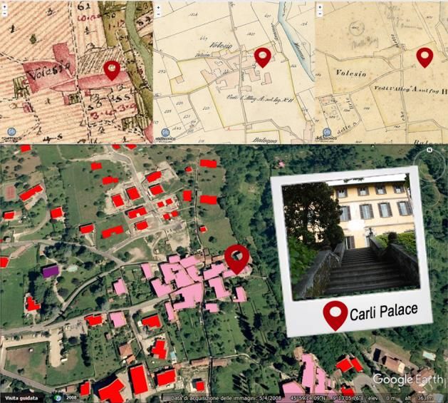
VIRTUAL MUSEUMS AND BUILT ENVIRONMENT:
                 NARRATIVES AND IMMERSIVE EXPERIENCE VIA MULTI-TEMPORAL GEODATA HUB

patrimonio cultural; surgen del proceso de mestizaje entre museos y tecnologías digitales. Investigar cómo la narración
digital puede apoyar la comunicación y la comprensión de sistemas complejos, como el entorno construido y el paisaje,
es relevante porque la conciencia cultural puede fomentar el sentido de pertenencia y la construcción de identidad de los
que Europa tiene sed, contribuyendo a la protección de sitios frágiles. El artículo proporciona información útil para los
museos que deseen seguir este camino. Describe los principales pasos que deberían considerarse a la hora de producir
narrativas y pone ejemplos interesantes de modelos narrativos inmersivos basados en datos geoespaciales y centros
virtuales, que ayudan a las personas a recuperar y acceder a información, y a reconocer lugares desconocidos o
vagamente retenidos en la memoria. Además, ofrece una evaluación de las herramientas existentes que se pueden
adoptar con este propósito. El objetivo es aclarar, finalmente, en virtud de la investigación desarrollada en el caso de
estudio del Museo Virtual del Paisaje del Lago di Como, qué tipo de historias y experiencias se pueden diseñar, el
potencial de estas herramientas y las posibles debilidades o limitaciones que merecen futuras investigaciones.
Palabras clave: museo virtual; narración digital; entorno construido; conciencia cultural; tecnologías digitales;
experiencia inmersiva

1. Introduction                                                 2. Virtual museum to communicate built
The theoretical reflections and debate of the last                 environment
decades have created a breeding ground to                       2.1 Built environment and landscape as human
acknowledge to landscape a more extended cultural               value and cultural heritage
meaning.
                                                                Nowadays, the concept of landscape has reached a new
The effective raising awareness process about its
                                                                maturity that allows us to consider it as a constantly
potential contribution to the local cultures, to the human
                                                                changing archive, a “palimpsest”, a document
well-being and identity construction, and to “the
                                                                permeated by human and natural historic traces with
sustainable social and economic development”
                                                                richer and broader meaning alongside aesthetic and
(ICOMOS, 2008a), needs to be supported by a new way
                                                                naturalistic appreciation (Scazzosi, 2003; Scazzosi,
to access and understand the rich and complex stratified
                                                                2004).
system of information about it. “The spirit of place is
made up of tangible as well as intangible elements”             The European Landscape Convention (2000), and more
(ICOMOS, 2008b), consequently, they must be both                recently ICOMOS Florence Declaration (2014),
considered in the built environment and landscape               corroborate this view and they go further stating:
analysis.                                                       “landscape contributes to the formation of local cultures
                                                                and that it is a basic component of the European natural
The research aims to investigate how a series of
                                                                and cultural heritage, contributing to human well-being
resources (from different Institutions, Historical Map
                                                                and consolidation of the European identity” (Council of
Archive, Europeana Collections and initiatives) including
                                                                Europe, 2000). “Landscapes are integral part of heritage
paintings of the landscapes and landmarks, historic
                                                                as they are living memory of past generations and can
cadastral and territorial maps and panoramas, can be re-
                                                                provide tangible and intangible connections to future
used, exploited and valorised (beyond their artistic and
                                                                generation. […] Increasing knowledge and cultural
aesthetic values), thanks to the opportunity of
                                                                awareness of the heritage of a place fosters meaningful
contextualization and comparison, experimenting
                                                                inter-cultural dialogue, engenders respect for cultural
innovative geo web-based applications enriched by
                                                                differences at a personal level. […] It is the foundation
narratives. The purpose is to offer an overtime space
                                                                for peaceful co-existence” (ICOMOS, 2014).
experiences of the landscape that helps users to
understand transformations occurred, to identify historic       Today, we are faced with a new, young and not
traces and permanence as well as to foster recognition          completely mature Institution as Europe is, placed side
of landscape values.                                            by side to the pre-existing national level, adding further
                                                                complexity to identities issue. People have always
The final goal is to allow a critical touristic way to share
                                                                possessed different cultural identities (Castells, 2000),
and experience the community identity of a historical
                                                                so, the matter is not how to replace their national with
landscape, exploiting the possibilities offered by the
                                                                the European one. We look first of all at Europe
different emerging digital tools and technologies.
                                                                because, besides being directly the closest reference
The application is specifically addressed to people             environment, it is an entity still in the process of being
interested in visiting the Museum of Landscape of Como          fully made into its own by society, where the discrepancy
Lake (Lago di Como) and the Tremezzina area. A                  between the Institution and “popular feeling” is palpable.
multimedia-system has been designed and implemented             Here, probably more than elsewhere, the memory-
to support during the virtual museum visit boosting the         heritage-identity systemic approach is the main option to
on-site visit across the unknown themes selected,               trace and image a future according to the view that “how
improving the understanding of the values of the                we conceive the future has implications for how we
Tremezzina’s landscape among different targets such as          conceive the present and the past – and vice versa.”
tourist and locals.                                             (Macdonald, 2013).
Different narratives supported by the geospatial space          The concept of cultural identity is strictly related to the
have been tackled as proposed by the Virtual Museum             authenticity of our cultural heritage and the associated
of Como Lake Landscape within the framework of the              values (ICOMOS, 1996). The goal of preserving, sharing
same name museum, analysing potential and limits of             and disseminating cultural heritage must be approached
web-accessible data and related information to improve          by aiming at identifying and enhance the deeper tangible
the attractiveness of the places before the visit and           and intangible values of a site. The process of identifying
during the visit as well.                                       and transferring those values is not always agreed upon

Virtual Archaeology Review, 9(19): 34-49, 2018                                                                          35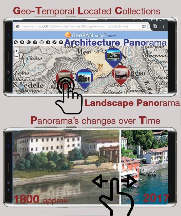
BRUMANA et al., 2018

by the various people involved in the landscape analysis,        have controversial and tangled histories, of which
conservation and planning, and it requires adaptable and         Europe has many 1,2,3.
implementable tools. Innovative digital tools represent a
new possibility to narrate different histories on a site,        Storytelling is a method of interpretation, a way to inspire
always to be considered as a partial point of view of a          an internal dialogue and ensure a real connection with
most complex and articulated situation.                          visitors as well as a strategy for realising an environment
                                                                 where visitors are encouraged to create their own
                                                                 meaning (Bedford, 2001; Wong, 2015).
2.2 Virtual museum and digital storytelling for
the dissemination of landscape knowledge                         A museum is defined by the International Council of
                                                                 Museums (ICOM) as “a non-profit, permanent
In recent years, museums have been attempting to do              institution in the service of society and its development,
more than preserving and conserving artworks and                 open to the public, which acquires, conserves,
remains. Prioritising themes, ideas and relationships            researches, communicates and exhibits the tangible
may be considered one of the strengths of the modern             and intangible heritage of humanity and its environment
museum (Hooper-Greenhill, 2005). This trend offers the           for the purposes of education, study and enjoyment”.
opportunity to define new methods of interpretation that         Within the framework of Virtual Multimodal Museum
are especially suitable for presenting complex system            (ViMM) EU project4, an updated definition of virtual
such as the built environment (BE) and landscapes in a           museum is on course of discussion, underlining the
museum.                                                          role of narrative in augmenting the information
Additionally, museums have been called to open up their          through the interactivity and content enrichment:
doors to an increasingly wider audience. This has asked          “virtual museum (VM) is usually, but not exclusively,
them to define alternative modalities of encounters that         perceived as a digital entity that draws on the
may be especially appealing for those categories who             characteristics of a museum, in order to complement,
are not usually accustomed visitors, and to push for             enhance, or augment the museum experience through
using cultural heritage as a tool to foster a reflective         personalization, interactivity and richness of content”.
behaviour and sense of belonging within societies.               An expert Advisory Group in building the ViMM
Investing in VMs development lies in the fact of their           Framework, involves decision-makers and expert
greater flexibility compared to traditional museums that         practitioners in defining and resolving issues spread
makes them an ideal environment to propose a new                 across 7 interlinked Thematic Areas: TAs (‘the 7 Ds’):
method of communication, to offer innovative ways to             Definitions–Directions–Documentation–Dimensions–
encounter heritage, to extend the paradigm of                    Demand–Discovery–Decisions: particularly ongoing
experience (AT home-IN museum-ON site) as well as to             Reports on Cultural Metadata Standards and three-
engage different communities.                                    dimensional (3D) Standard formats highlight the
                                                                 progressive role of 3D data content improving
Up to today, VMs have been many things. There is not a           knowledge transfer potential.
single model of VM, and it is not merely a matter of
definition of course (Caspani, Brumana, Oreni &                  3. The built environment of Tremezzo and
Previtali, 2017). Under the name of VM are virtual tours,
digitalised collections, and dedicated web pages which              its communication
are commonplace. VMs appear often as a sort of                   Tremezzo is located on the left side of Como Lake. This
“simple” digital replica of the real one. However, in all the    area has a complex landscape structure which is the
forms already tried out, they have supported a more              result of the natural characteristic of sloping terrain
democratic access to culture. An important project such          morphology facing on the beautiful Lake of Como and
as      Google     Art    &     Culture    or   Europeana        the different uses of the land from the agricultural
(http://www.europeana.eu) could do something more.               activities of the past until to the tourist vocation started
They have offered access to different museums or                 from the 19th century. Nowadays, it is characterised by
collections from a single webpage, making users life             the famous water view front on the lakeside with a high
easier and enriching the experience in term of content           pressure of aggressive tourism, an underestimated
available and content automatically suggested thanks to
a well-structured internal system of semantic research.
However, they still struggle to show what there is               1
beyond the digitalised object in itself.                             See the Manifesto of the HORIZON 2020 project CulturalBase
                                                                     (Social Platform on Cultural Heritage an European Identities)
A narrative is a powerful tool for museums and VMs                   http://culturalbase.eu/
because it follows in structure how people learn. Human          2
                                                                      For instance, the no-profit association CHwB (Cultural
beings make sense of the world and themselves through                Heritage without borders) in its strategic plan 2013-16
narrative and it is basically the instrument for making              declares “cultural heritage is used as a tool for creating a
meaning (Bruner, 1991). The scenario opened by the                   better understanding of our shared and diverse pasts and as
                                                                     a building block in the effort to promote democratic
narrative approach may contribute to making accessible
                                                                     development.”
and comprehensible the tangled relations that in other           3
ways are difficult to be appreciated and understood by               EUROPEAN COMMISSION, 2014, Towards an integrated
                                                                     approach to cultural heritage for Europe.
the public as often happen in the case of the landscape.         4
The digital narrative may be used to show how objects of              ViMM (https://www.vi-mm.eu/) is a high-visibility and
                                                                     participative action under the H2020 CULT-COOP-8-2016
culture have different valences in different parts of
                                                                     EU, which brings together Europe and the world’s leading
Europe. It may be the glue to connect the various points             public and private sector organisations working on Virtual
of view about controversial historical events as well as it          Museums and in the wider sector of Digital Cultural Heritage
may support a sense of belonging and identity                        (DCH), to support high quality policy development, decision
construction, especially with regards to field sites which           making and the use of technical advances.

Virtual Archaeology Review, 9(19): 34-49, 2018                                                                                 36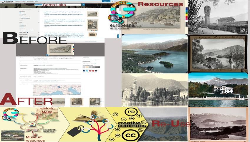
VIRTUAL MUSEUMS AND BUILT ENVIRONMENT:
                  NARRATIVES AND IMMERSIVE EXPERIENCE VIA MULTI-TEMPORAL GEODATA HUB

hillside band (with beautiful landscape, drywall terraces     4. Built environment and the experience of
and palaces, that is living a phasing-out of the ancient         the Virtual Museum of Como Lake
cultivations, that made famous and rich Tremezzo during
the 17-19th centuries, with a lack of maintenance and            Landscape
lack of identity by the inhabitants) and mountain pastoral    The territory of Tremezzina (Como Lake) is historically
agroforestry on transformations (Brumana et al., 2015a).      well known for its beautiful landscape and built
In recent years many different projects have been             environment with many architectural emergencies of
funded by the Municipality and the Lombardy Region5, in       great attractiveness, as Villa Carlotta, or the star-system
order to support studies on this landscape, to enhance        Villas. In the recent years, the enhancement of its
its history and consequently to promote a sustainable         cultural heritage (in the extended definition) has been a
tourism (Fig. 1). To this aim, the complex, interactive and   key issue for local bodies that have invested (also
multimedia digital techniques can have an important role      thanks to funded Interreg projects) in realizing a new
in supporting the comparison between past and present         dedicated museum and creating a network among the
landscape.                                                    local cultural Institutions to exploit the touristic capacity
                                                              of catalysts such as Villa Carlotta (about 200,000
                                                              visitors/year) with the hope to enhance and support a
                                                              widespread micro tourism across all the area spanning
                                                              about 20 km from Como to the North.
                                                              The “Museum of Como Lake Landscape” (Villa Mainona,
                                                              Tremezzo, Como) concept framework was explicitly
                                                              designed to raise awareness about such values of this
                                                              territory and to spread knowledge about its history
                                                              among local communities and tourists (Figs. 2 and 3).
                                                              In fact, nowadays, tourists remain nearby the lake for
    Figure 1: The website of Como Lake greenway (2002-2007)   summer sports. The lack of information and awareness
       (https://greenwaylagodicomo.com/it/esplora/?id=146).   of the richness of the studied area, with its values and
                                                              ancient traces, has led to a deserted environment in fall
In particular, the theme of the voyage through cultural       and winter.
routes, by land or by lake, allows today to reconstruct
and reconnect the history of places, villages and people      The European Landscape Convention stated the
who in the past lived and transformed this landscape. As      important link between the role of connecting people, for
indicated by ICOMOS (ICOMOS, 2008a), cultural routes:         the growing of a reflective society, and knowledge
                                                              creating in safeguarding cultural heritage, proposing
      include a joint system which enhances their             specific measures for the identification and assessment
      significance. This integrated, interdisciplinary and    (Council of Europe, 2000). According to that, the project
      shared framework creates new relationships among
      them by means of an innovative scientific
      perspective that provides a multilateral, more
      complete, and more accurate vision of history. A
      Cultural Route can be a road that was expressly
      created to serve this purpose or a route that takes
      advantage either totally of partially of pre-existing
      roads used for different purposes. But beyond its
      character as a way of communication or transport,
      its existence and significance as a Cultural Route
      can only be explained by its use for such specific
      purpose throughout a long period of history and by
      having generated heritage values and cultural
      properties associated to it which reflect reciprocal
      influences between different cultural groups as a
      result of its own peculiar dynamics.
An example is the ancient “lemons road” that was used,
since 15th to 19th century, by the merchants (in particular
Brentano Family and other famous families) to bring
citruses from Tremezzina to Riva di Chiavenna, Lindau
and finally to Amsterdam and Frankfurt markets
(Pini, 2003).
This breadth of scale is fundamental in the analysis of
the landscape to understand the richness got in the past,
and importance today of Tremezzina and the connected
built heritage, considered as a whole system.

5
    Accordo Quadro di Sviluppo Territoriale (AQST) Magistri
    Comacini, and Ecolarius, Lombardy Region, 2005.           Figure 2: Concept framework of an innovative model of VM for
                                                                            Built Environment & Landscape.

Virtual Archaeology Review, 9(19): 34-49, 2018                                                                          37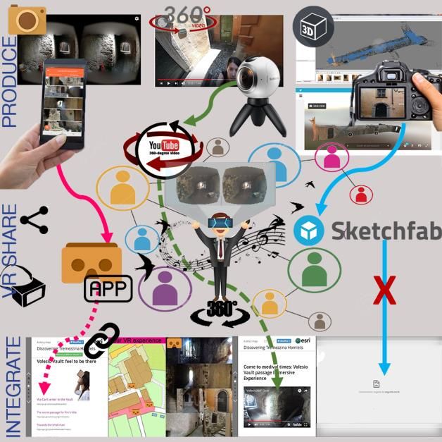
BRUMANA et al., 2018
Two touch screens, connected each one to a wall
projection, involve people with different sections that
visitors can choose during the navigation (Fig. 4).
Figure 3: Multi-temporal narratives based on historical maps
related to the current space can facilitate inclusive processes
through people involvement and identity rising. Figure 4: Virtual Museum of Como Lake Landscape (collection,
the multimedia system by ©Gicarus Lab). The multi-media
system based on multi-temporal geospatial data navigation.
of the museum aims to raise the awareness of
landscape, the objective of this research is to identify a
The multimedia system has been based on different
dissemination methodology, correlating and managing,
multi-temporal geospatial data supported by historical
as many of the remained traces, the viewable, the less
maps related to the current ones. Different map
viewable and the untraceable values experimenting a
navigations have been implemented taking into account
sort of Geo-SWOT (Strengths, Weaknesses,
two different typologies of the maps:
Opportunities, Threats) chart analysis, combining values
with metric and non-metric multi-temporal view maps, Non-metric maps, i.e. the ancient Waterview front
ancient and current. maps, or perspective maps (Monti et al., 2009);
The Museum of Como Lake Landscape (partially opened Georeferenced metric maps, i.e. historical
to the public in September 2016) offers a traditional cadastres, and territorial military maps (Brumana,
permanent exhibition of historic panoramas of Como
Cuca, Oreni, Prandi & Scaioni, 2010).
Lake. It is complemented by a highly innovative
multimedia system, designed by Gicarus Lab of the The virtual museum visit has been conceived for
Politecnico di Milano and developed in collaboration with different visitors, from non-digital experts (including
an SME private company (NEMES SRL). It provides an ageing people, both tourists and local inhabitants) until
immersive and interactive mode to discovery the ‘digital natives’ with 3D navigation functionalities, in
landscape combining different digital data, information order to help people recognising the past and valorising
and contents with the intermediation of geographic the traces of the historical anthropic landscape. In
space to help the visitor to understand the history of particular, the following sections are available:
these places with the subtended aim to encourage the
Multi-temporal landscape navigation: historic water
visit on site.
view front map correlated to the current panorama of
4.1. The multi-media system: multi-temporal the lake, obtained along 20 km of coasts, helping to
geospatial data navigation recognise the landscape historical values;
3D historic map registration (Brumana et al, 2010;
Multi-temporal data access has been progressively
exploited during the last decade (Cuca, Brumana, Barazzetti, Brumana, Oreni & Roncoroni, 2013): a
Scaioni & Oreni, 2011) as a starting point to be enriched section visualising the historic cadastral maps
by related information, documents and pictures. georeferenced to the current map with overlapped
themes remotely managed on Google Earth©;
To reach this goal an interactive navigation system has
been developed within the ‘Multimedia system of the Tremezzo itineraries on Google Earth©: Google
landscape of the Municipality of Tremezzina on the Lake Earth© interface presenting the themes and
of Como’6. subthemes of the territory in a 3D ‘Virtual Globe’
allowing exploration and navigation of different
itinerary trips for the visiting people;
6
PORL FESR 2007/2013 (European Funding Research and
Development) ‘Multimedia system for the presentation and
participated recognizing of the environmental values of the
landscape of the Lake of Como’ (Sistema multimediale per la Realizzazione e promozione di itinerari turistici per la fruizione
presentazione e per il riconoscimento partecipato dei valori sostenibile delle risorse culturali e ambientali. Province of Como
ambientali del paesaggio lariano), Asse 4 Tutela e scientific responsible, with the support of Polimi (Prof. S. Della
Valorizzazione del patrimonio naturale e culturale, Line 4.1.1.1 Torre, R. Brumana for the construction of the Tremezzina
Promozione e diffusione di una fruizione sostenibile,… multimedia museum).
Virtual Archaeology Review, 9(19): 34-49, 2018 38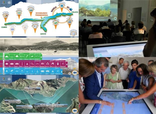
VIRTUAL MUSEUMS AND BUILT ENVIRONMENT:
NARRATIVES AND IMMERSIVE EXPERIENCE VIA MULTI-TEMPORAL GEODATA HUB
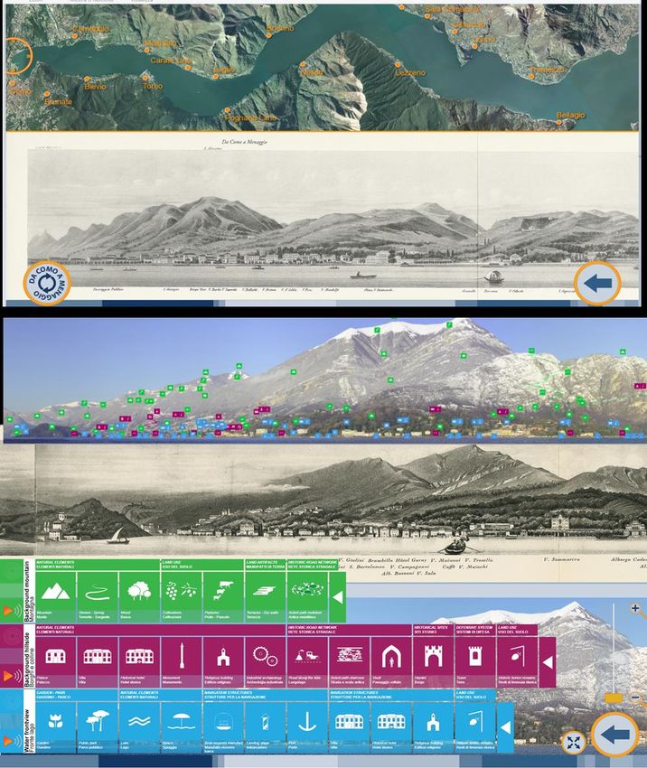
History of Tremezzo in Europe: Google Earth© Layer I (cyan) – Water view front – foreground layer:
interface presenting the EU geo-tree of the it is characterised by the famous Villa systems and
merchant families of lemon across Europe; Parks. The view front, nowadays under the pressure
Isola Comacina: the historical site of the Isola of the traffic road (commercial and touristic),
Comacina, viewed by the 3D drone orthoimage of represented in the past an important connection to
the archaeological site to achieve better detail than the North of Europe (the ancient Roman road on the
Google’s Imagery (Brumana et al., 2013). lake has been partially destroyed and lost due to the
transformations during the last centuries). The
navigation aims to relate the waterfront to the
4.2. Interactive offline non-metric panoramas
navigation, today and in the past richness of the background, to diminish the touristic
pressure on the Lake, and to underline the important
An interactive map navigation has been implemented connection to Europe in the past, as explained
offline, correlating the ancient perspective view of the
hereafter (Fig. 5, cyan icons).
waterview front and the current panoramic cones
obtained from the opposite lake-side image acquisition Layer II (magenta) – Hills and Hamlets – 1st
along the treat of the coast from Como city, background layer: it is characterised by the mostly
through Comune di Tremezzina until Menaggio unknown hamlets, which are unfortunately
(Barazzetti et al. 2013).
characterised by lack of preservation and
In particular, it was digitalised a precious historical map, awareness by the local people, nor visited by the
known among the inhabitants the “Panoramica da Como tourists. The navigation aims to highlight the traces
a Menaggio e da Bellagio a Como” (Gaetano of a rich dense network of the cobbled ancient
Brigola, 1863), that represents the waterfront of the two
paths, of the vaulted passages under the palaces,
sides of this part of the Como Lake, indicating the names
of the landscape natural and anthropic valuable the historical land use traced by its artefacts (i.e.
evidences: the top mountains names with the still terraces on the hill slopes, paths, water sources,
recognisable ridges, the hills characterised by the rich canalization, drywall), and lemon terraces
network of cultivated terraces and drywalls, the main cultivations now abandoned (Fig. 5, magenta icons).
villas and palaces’ name on the lake and in the hamlets,
the famous parks, and so on. Layer III (green) – Mountains – 2nd background
layer: the navigation aims to transfer the meaning of
The historic and current water view fronts have been the ancient history of anthropic landscape (Fig. 5,
navigated through a simple co-relation code, based on
green icons), with the old pathways for the seasonal
homologous points recognised in the two maps, thus
allowing to avoid stretching the correlated portions, grazing and pasture transfer (muleteer), still
introducing too high map deformations, and, at the same viewable, that could be inserted in a local centred
time, helping people to recognise the correspondent sustainable agriculture, increasingly growing in
places, as in the case of the ridges of the mountains, Lombardy Region (i.e. sheep wool and cheese
represented by different point of views in the two maps, production).
or the waterfront places. All the texts, coming from the
ancient map, have been made available with a small The section interactive offline non-metric panoramas
explanation (EN/IT) and related to pictures and videos to was conceived to encourage free user navigation and
allow a wider comprehension among people. discovery. It means that there is not a user’s pre-defined
order to follow, or pre-set navigation tours of the map.
Three different landscape layers have been highlighted
Indeed, the main drivers are user’s interest and curiosity.
with an immediate level of perception (three transparent
bands, at the waterfront level, at the hillside and at the The two compared maps act as a canvas of the
mountain level): a deeper narrative has been narrative. The division in three levels (each layer of
implemented and superimposed on the two maps, as a analysis, in the abstract, can be seen as a story
game-checker with coloured thematic icons following the composed by many “subsections”, as many as the
three coloured band-layer, to help the multi-temporal landscape elements identified using the icons) was
correlation in order to help visitors to navigate across the made to highlight the differences of this built
three landscape layers during the tourist trips and the environment, but also to offer a simple and not too much
multimedia museum visits. An easy interactive invasive guidance that can foster an organic and logic
navigation along the coast is made possible by turning narration.
on/off the different layers.
The landscapes views have been enriched by a series of 4.3. Web3D navigation through the historical
information to support visitors to perceive the value of cadastral maps
the built environment as a whole, avoiding limiting it just
For the native-digital public, and people using
to the lakefront, inviting them to a visit inside the
GoogleEarth© based 3D navigation, it has been
landscape across the richness of the hillside.
implemented a proof-of-concept Web3D application that
A number of themes and subthemes of the territory, allows the navigation across the centuries by mean of
highlighted by semantic icons, have been designed the historical cadastral map series with all the richness
and referenced in the two maps displaying the of details allowed by the scale (1:2000) with the help of
three landscape layers, with a brief description signs and graphic representations still recognisable on
(EN/IT) (Fig. 5): the current state of the art.
Virtual Archaeology Review, 9(19): 34-49, 2018 39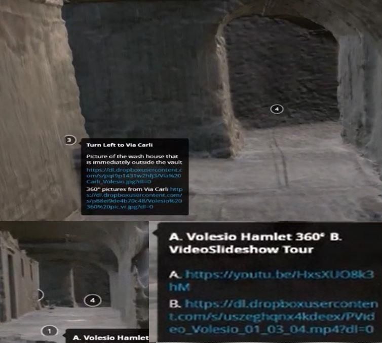
BRUMANA et al., 2018

Figure. 5: Interactive map navigation correlating the ancient perspective map view from Como to Menaggio and the current panoramic
                  cones enriched by the semantic thematic icons (i.e. hamlets, villas, ancient paths, drywall terraces).

Such experiment may be scaled and adopted, in its                   The starting point of a geo-web based navigation has
framework and architecture, by other Institutions to                been motivated by the idea to attract people visiting the
stimulate people awareness about stratified values of the           Lake of Como, using a common geographic based
built environment. The use of correlated cadastral maps             navigation interface (in this case Google Earth©)
can facilitate recognition of historical centres and place          accessible both during the museum visit and during the
them on the timeline. This kind of maps, in fact, can               ‘on-site’ visit. Furthermore, we have bet on the potential
become an important vehicle of information from the                 support arising from the use of a geographical space
past to the present especially when there is a lack of              well-known in order to reduce to a minimum the
existing permanence.                                                technological barrier at least.

Virtual Archaeology Review, 9(19): 34-49, 2018                                                                                  40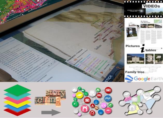
VIRTUAL MUSEUMS AND BUILT ENVIRONMENT:
                 NARRATIVES AND IMMERSIVE EXPERIENCE VIA MULTI-TEMPORAL GEODATA HUB

In order to navigate across the multi-temporal maps of         nor in the explanation, for this reason, a number of
the historical cadastre in a three-dimensional                 legends, in the form of static JPG picture, have been
environment, a Google Earth© based web solution has            added to help in the multi-layered map reading.
been firstly chosen as an easy and flexible solution. At
the time of the choice (2014-15-16), a number of API
were available to customize the interface in order to
obtain different targeted thematic virtual visits across the
hamlets, the ancient paths, the terraces, the villas, and
the hills.
The geographic layers have been enriched by the GIS
thematic layers generated to facilitate the fruition and
comprehension of the historical maps series and the
current transformation and permanence: ArcGIS© layers
have been converted in KML layers and then imported
into Google Earth© for accessible navigation. Each
added layer brings specific information according to the
themes that were carefully identified and selected during
the student internship of Ms Daphne Roels, in
collaboration with Leuven team, for dissemination
purpose taking into account the results of geo-swat
analysis previously made on Tremezzo area.
Among them, the digitization of the ancient paths and
buildings on the current maps have been extracted,
assigning different colours, where recognizable the                                         (a)
historic permanence, characterizing the current
map canvas: pink –Catasto Teresiano (XVIII)–, purple
–Catasto Lombardo Veneto (XIX)–, brown –(Cessato
Catasto (XX)– (Fig.6a). The choice to work on the
vectorial layers of the current maps was motivated by
the importance to underline the transformation,
permanence and mutations, occurred from the past
(readable on the ancient maps) till to the current state of
the art. Current buildings in the hamlets, villas and
palaces, together with the road network have been
highlighted and coloured evidencing the features                                            (b)
surveyed by the different historical cadastral                    Figure 6: The Google Earth © implementation: a) use of
maps (Fig. 6b).                                                    historical cadastral map series to read of transformation
                                                                     permanence and mutation and allocate, for instance,
This approach allows to deeper investigate the level of
                                                                 architectural heritage in time; b) example the geo-thematic
conservation, maintenance and use transformation in            layers generated from ArcGIS© on the historical cadastral map
order to sensitise people toward the conservation aims.                     series (©POLIMI, dABC LAB - Gicarus).
Unfortunately, during the thematic implementation of the
virtual museum, the policies of Google Earth© changed,         5. Geopan App - VM: toward open data
the customization of the graphics interface was no more           hub for VM hamlets fruition
allowed to the developers, nor free of charge nor
paying costs.                                                  In the vein of what above, the research seeks to develop
                                                               new communication tools that take benefit also from
As results, all the narratives implemented couldn’t be         re-use of open data (Cuca, Previtali, Barazzetti &
separately managed, enriched by ad hoc legend,                 Brumana, 2017) generated on the historical
explaining tests, with some evident critical issues for the    georeferenced maps combined with other cultural digital
visiting people, obliged to select among many layers the       resources in a geo-temporal better customisable
interesting ones.                                              interface.
This unexpected circumstance has drastically reduced           The aim is to enhance the current level of the
the possibility to customize the graphic design of the         geographic data fruition by remote Web3D access,
environment and contents. The geospatial interface, in         implementing an available application developed to
fact, can host information only as an additional layer.        boost the redistribution of geographic open data, tuning
This aspect makes difficult an independent navigation          it for the specific case of virtual museum access, a
and a full understanding of the relation among                 ‘Geopan App - VM’ driven.
landscape’s elements by common users if they are not
guided by museum operators, as underlined during the           Open Access Atlas and related services, Open
inauguration of the museum.                                    Geospatial Consortium (OGC) and Inspire compliant,
                                                               have been introduced among the historical map services
The Google Earth© interface implemented, even                  for many years, allowing a number of analysis of
attractive for the 3Dnavigation and richness of themes,        transformations of the built environment in order to
has shown a critical limit in the fruition by the people,      support sustainable planning and a better knowledge of
having too many choices in the layer selection with no         the state of the art (Brumana, Oreni, Cuca, Rampini &
one graphic customizable support to help in the choice         Pepe, 2012). The bet is to gradually use such

Virtual Archaeology Review, 9(19): 34-49, 2018                                                                            41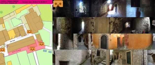
BRUMANA et al., 2018

opportunities within the virtual museums to improve
narrative storytelling empowered by the open access
services developed on the historical maps. Virtual Hub
brokering and accessing services, based on temporal-
spatial and semantic subsetting, have been recently
introduced and applied to the large dataset as in the
case of GEO global Earth Observation (Nativi, Craglia &
Pearlman, 2013).
GeoPan Atl@s APP (http://www.atlas.polimi.it/it/energic-
od/geopan-atls/) was born from Polimi –dABC LAB-
Gicarus, providing rapid and facilitated access to multi-
temporal historical cadastral and topographical maps
(Brumana et al., 2015b) through an open source
geoportal using a European Virtual Hub (Previtali, 2017).
It can integrate geographic data as well as open data
thanks to an advanced brokering system and
exploitation of virtual hubs potential that was made
possible in the last development within the three-year
project     ENERGIC-OD         (https://www.energic-od.eu)
funded under Competitiveness and Innovation
Framework Programme (CIP). The Geopan App web-
based application has been developed for desktop and
mobile; it can rely on a double modality of access, via a
web browser or via an Android application, for a flexible
use (on site, at home, etc.). Thus, it is ready to be tuned
in support of geo-based narratives to raise awareness
among visitors of an unknown piece of history, as the
hillside area of Tremezzo.
                                                                 Figure 7: The Geopan APP allows users to personalise the
With this aim, the application, Geopan App                        graphics interface simplifying user access to the different
(http://geoserver.atlas.polimi.it/examples/servlets/Geopa       contents; it also supports thematic searches content focusing:
n/D/web_APP/index.html) have been updated - using a            research based on semantics, re-use of geographic information
                                                                  and open cultural data (© POLIMI, dABCLAB - Gicarus).
Virtual Hub brokering and accessing services - with the
series of historical cadastral maps and with the open
layers of Como Lake generated for the Google Earth©            merchants across Europe through the ‘lemon route’,
application. It supports multiple thematic modalities of       coming from Tremezzo getting European cities to sell
research based on semantic and temporal subsetting; a          lemons cultivated in the 17th century on the Lake of
simultaneous visualization of different superimposed           Como, and particularly in Tremezzo. They exchanged
historic maps facilitated by the layers manager                such precious products, antibiotics were not available at
implemented. Furthermore, it offers basic features such        that time, buying spices arriving from the north harbours
as: drawing on the map, take video, geolocation, path          (i.e. Rotterdam, Amsterdam) building a dense network of
tracking that may encourage an active users’                   Emporium across European cities (i.e. Lipsia, Berlin, and
involvement and contribution.                                  many others) through the network of relatives, sons
                                                               cousins and so on. Getting rich, they built precious
It can contribute to allowing the visitor to know the          Palaces and Villas in Tremezzo that are still existing (i.e.
territory of Tremezzina and Lake Como giving access to         the Brentano’s family Palaces, the Carli’s family Villas).
a richer "multi-institutional" collection of historical
panorama views of Como Lake (part of the collection of         Since the beginning, this story was identified as one of
Museum of Como Lake Landscape and additional                   the most representative of the main transformations
resources available in Europeana) within a geo-temporal        occurred on Tremezzina landscape, attractive and
web base environment, that can be used within the              suitable to rethink the presentation according to a
museum, at home and on-site for an extended                    storytelling approach. Since 2017, after a preliminary
experience.                                                    investigation of available software and platform that
                                                               move forward traditional GIS architecture towards a
Last but not least, it is characterized by a friendly and      storytelling presentation (Caspani at al., 2017), it has
intuitive interface in virtue of continuous involvement of     been made a first attempt that has taken advantages of
customer and stakeholder, showing the favourable               the web-application Story Map from Esri. In this case,
response from final users (Fig. 7).                            the story was “written” using a model of pre-ordered full
The migration of all the data, layers, images and video        frame sections (central frame for the main source of
from the Google Earth© interface (enriched by                  information, the lateral band for text and secondary
explanations and related information) is ongoing. The          contents) one after the other. In each section «thematic
possibility to use search functionalities based on             map» (designed to present only relevant GIS data,
semantic word and temporal selections can be used to           migrated, in our case, from the more reach and an all-
personalize and develop the different narratives in            inclusive map of Google Earth) are usually the story
function of the visiting preferences.                          driver with a starring role. Story workflow has foreseen:
                                                               storyboard of the narrative for its segmentation (how
The interface can be personalised, selecting few themes        many sections, main topic of each one, presentation
for each storytelling, focusing single themes in the           order), selection of «relevant information» KMZ layer
museum visits. For instance, the history of the                that should be migrated from Google Earth and, finally,

Virtual Archaeology Review, 9(19): 34-49, 2018                                                                              42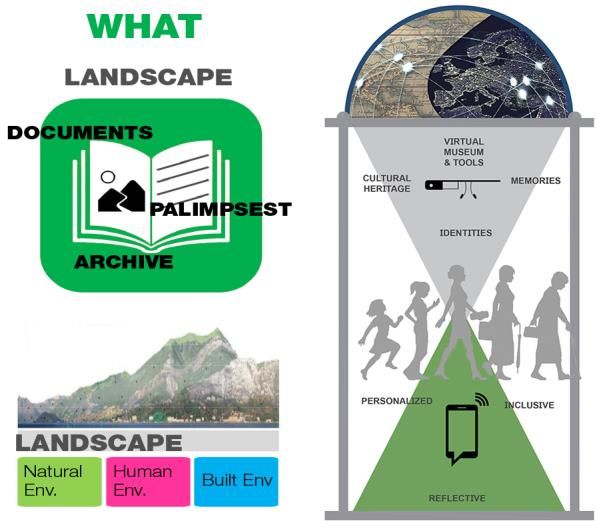
VIRTUAL MUSEUMS AND BUILT ENVIRONMENT:
                 NARRATIVES AND IMMERSIVE EXPERIENCE VIA MULTI-TEMPORAL GEODATA HUB

development of additional contents that enrich the story          compared. In this way the experience of the territory in
and open the door to immersive experience.                        the past will span from the traditional 2D-3D
                                                                  representation to the integration of the ancient
Wanting to avoid a solely rely on a non-proprietary               perspective views, correlating the 2D-3D metric
software and wishing to open up to the possibility of             representation to the non-metric perspectives.
integrating open data as additional contents, it has been
embraced the idea of using Geopan App, which can                  Geo-localization plus tracing of optical cones within the
better guarantee customisation perspectives. The work             geographic space will drive the user to contextualise
of structuring the narrative, as a series of thematic maps        the panorama with respect to the territory (also
with additional contents, was repurposed for the                  a time contextualization thanks to the integration
development in Geopan App.                                        of historical maps as navigation base) with the support
                                                                  of an illustrated timeline. Linking historical 2D and 3D
5.1. Toward web-based historic panoramic                          information (maps and panoramas) is intended to help
view related to current views: Europeana                          users, even non-experts, through the recognition of
Collections OD                                                    the ancient optical cones of view registered by the
                                                                  ancient maps and to correlate and appreciate the
These promising aspects in the enhancement of                     current ones enriched by stratified values. In this
storytelling instruments, supported by geospatial data,           regard, it is expected to implement an easy and
are interesting premises that suggested implementing              intuitive user-friendly feature to compare images
the Geopan Atl@s App - VM to integrate the geolocated             relating historical and current views.
historic panoramic view of Como Lake, coming from
available Europeana Collection, within a multi-temporal           The main purpose of this further enhancement is to
geographic environment.                                           boost the understanding of the ancient panorama
                                                                  exhibition, realised in the Museum of Como Lake
A potential adoption of the Geopan App - VM of Como               Landscape, coming from very precious collection but,
Lake Landscape - as well as to put in place a possible            sometimes, not fully comprehensible by the large
re-use of open cultural data already available in digital         public (Fig. 9).
repository such as Europeana (historic panorama of
Como lake, paintings depicting customs and traditions,
influential people, etc.) could enrich even more
informative and communicative dimension of the
exhibition of the ancient maps (Fig. 8).

 Figure 8: The conceptual framework for a possible re-use of        Figure 9: Panoramas in Geo-Context (on development): a
Europeana open data collection: historical perspective views of    historical perspective view of Ossuccio and the optic cone of
         the Como Lake (courtesy of Sara Caspani).                 the view referred to the historical military map (19th century).

The main objective is to implement a friendly and                 The intention of the direction of the Museum is
intuitive interface in virtue of continuous involvement of        to promote a better comprehension of the exhibition
customer and stakeholder. Given that, comprehension of            valorising the ancient maps of the lake landscape
ancient perspective views is often hard for the public, it        with their beautiful views, helping the discovery
has experimented with the potential of geo-based                  and recognition of the current corresponding views,
redistribution of such views for helping people to better         developing an ad hoc interface to locate historic
correlate them to the current space.                              ‘Panoramas in a Geo-context’ in order to highlight
                                                                  the ‘Panorama’s changes over Time’ and also to valorise
The research would like to offer the opportunity to enrich
                                                                  the     conic   views    and     bird    views   maps
the app with a new feature of images comparison
                                                                  available as open data belonging to Europeana digital
(historic panorama and current views) by correlation of
                                                                  data     set   (resources    about      ComoLake     at
the homologous points as obtained in the upper
                                                                  https://www.europeana.eu/portal/it/search?q=Lago+di+
described case (see Section 4.2).
                                                                  Como), being that the maps exposed in the Museum
By way of example: JuxtaposeJS, imgSlider, Cocoen,                have not been yet digitalised due to the
Image Comparison Slider, have been considered and                 museum opening matters (Fig. 10).

Virtual Archaeology Review, 9(19): 34-49, 2018                                                                                    43
BRUMANA et al., 2018
adaptation and reply of the market to the current trend of
digital contents consumption. Spatial dimension is
leading this evolution, and, as proven by the test,
5/8 tools assume maps in quality of fundamental
content. The possibility of “read-and-write” online maps
has given rise to the geospatial web. Maps have become
common in everyday life, people are accustomed to
using web services such as Google Maps that have
popularised and democratised the power of maps by
enabling people to add and share cartographic contents
(Giaccardi & Fogli, 2008). Maps are more and more
commonly used as an analytical tool to explore the
spatial dimension of narratives (Caquard, 2013). The
appearance of terms such as ‘Story maps’ (by Robert
MacFarlane), ‘fictional cartography’, ‘narrative atlas’ and
‘geo-spatial storytelling’ is an evidence of the growing
interest in the relationship between maps and narratives.
Maps may take on the role of "showcases" of the plot of
relations. They may: host multiplicity of point of views,
enlarge the angle of prospective or be used like a hand
lens, welcoming a deeper meaning understanding.
A growing number of map-based storytelling tools (i.e.
1. Google Tour Builder, 2. Google My Map, 3.Story Map
ArcGIS Esri, 4. Odyssey, 5. Storymap JS Knight Lab,
6. Timeline JS Knight Lab, 7. Meograph, 8. Atavist),
testifies the interest to boost storytelling starting from the
Figure 10: Concept framework for a geo-time space application map contents. To provide a useful comparison and
to valorise landscape knowledge by an innovative access to assessment about completeness and flexibility of the
digital cultural open data (courtesy of Sara Caspani). tools, the following main parameters have been
considered: modality of the log, digital contents
The Geopan App - VM ‘Panoramas in Geo.Context’ supported and compatible channels where sharing the
would like to: story (particularly oriented in tracing interoperability with
Present the app and its functionalities to refer to the social media platforms), live web access.
ancient perspective views on the historically On the base of this analysis, the requirement of live web
registered 3D maps, through the optic cone view access and its capacity to manage different data
(with posts and short videos); (GeoTIFF, pictures, vectorial layers, videos, explaining
text) has been chosen in the case of the Virtual Museum
Create a digital simplified timeline of the history of of Como Lake Landscape.
Como Lake with the contents from Europeana and
external resources (enriched by short stories about In the vein of what is stated above, the last consideration
about the tested software for digital storytelling: these
the represented place) with the aim to raise
tools are addressed to a wide range of stakeholders and
awareness about Como lake, the existence of not properly developed for museum storytelling. In this
Europeana collection and, more in general, of digital aspect, we ascribe a plausible reason for which 3D and
cultural heritage; immersive contents are not yet fully supported. We
believe that this aspect is a paramount interest that
Offer a space where the community is encouraged
deserves further researches and developments in IT
to share resources (e.g. current and historic pictures solutions, but also projects such as Europeana that has
of Como Lake inside dedicated Facebook albums), been developing and disseminating 3D cultural contents,
to propose keywords for an intuitive research of data may offer cues of the solution in the nearest future.
inside Europeana (for instance with a campaign
The main objective is to help people, during the museum
Write your #Hashtag) and, eventually, to leave visit and on-site visit, to be aware of the complexity of
feedback about the app (useful to evaluate points of landscape themes and values, in a way customisable for
further developments); the users. For this matter, as the first step, it has been
chosen to implement a geo-based web interface. As
Stimulate the use of the tools within many other
previously reported, the technical constraints emerged
applications re-using the huge map heritage already during the design process with Google Earth, have been
available within Europeana, boosting the impact at overcome by the new Geopan App interface. From this
an EU-Scale. starting point, it has been hypothesised a storyboard in
A direct involvement of the Museums and local touristic order to facilitate the content comprehension by the
offices is foreseen to reach a wider public. visitors geolocating immersive virtual tour.
In the case of the virtual museum of Como Lake
6. Maps and narrative: storytelling and Landscape, a number of landscape themes of the Lake
immersive navigation of Como, with a focus on the hamlets (i.e. Volesio,
Intignano, and many others) of the Tremezzina area,
The progressive increase of visual, spatial and temporal have been selected in order to attract people visiting the
based storytelling tools can be probably explained as an background landscape of the hillside. A storytelling
Virtual Archaeology Review, 9(19): 34-49, 2018 44VIRTUAL MUSEUMS AND BUILT ENVIRONMENT:
NARRATIVES AND IMMERSIVE EXPERIENCE VIA MULTI-TEMPORAL GEODATA HUB
dashboard has been drafted in order to boost the Tremezzina, as a case study of the PhD thesis of which
comprehension by the people and it will be fully this work is part.
implemented in the future as soon as the fundraising will
allow its enhancement (Fig. 11). We focus our attention on Tremezzina hamlets with its
picturesque architectural perspective and historic vault
passages that contribute to the charm of these places.
Valorisation, in this case, also passes through an
increasing visibility. If the web allows reaching a bigger
audience, immersive content (panoramic photos, 360°
videos, three-dimensional models) can be captivating
tools able to attract the public's attention.
The following goals are set:
making the audience curious;
offering the chance to have a first experience or
retrieve the experience made on site;
adding extra information, where possible.
Three different low-cost ‘ready to use’ immersive
contents (or quasi-immersive) have experimented on the
common theme of the vaulted passages virtual tour:
Figure 11: Example of contents and the schematic proposal of
an alternative approach offered by digital storytelling. Panoramic photos (cardboard fruition);
‘augmenting’ the geocontent in a more explicit and 360° videos (YouTube access);
comprehensible way for the visitors.
3D photogrammetric model fruition from web
People visiting the virtual museum can navigate the platform (Sketchfab navigation).
ancient hamlets and paths highlighted by the cadastral The different solutions are underway to make them
maps layers of the new Geopan App interface, enriched available in the future within the multimedia system of
by the GIS layers of the current maps integrated in the the Virtual Museum of Como Lake Landscape, by
interface, using the map contents as a canvas to remote access, in the different allowed formats.
recognise pictures and videos georeferenced to the
maps, about the hamlets and different places to visit. 6.1.1. Low-cost panoramic photos for cardboard
fruition
6.1. Virtual immersive tour across the historic
To present a series of typical corners of the hamlet we
vaulted passages of the hamlets used panoramic photos made directly by the smartphone
It has been decided to enrich the virtual museum geo- applications. Most of new smartphones or tables are
contents with a virtual tour across the vaulted passages equipped by native applications for panoramic photos
and an ancient path connecting the hamlets. but, a step ahead is offered by application specifically
designed to view panorama with an entry level of VR
The objective is to allow people to access the immersive headsets. For instance, Google offers free of charge
tour across the 3D vaulted passages, from a number of Cardboard Camera or can be easily acquired with a low-
predefined points, distributed on the maps (Fig. 12). cost cardboard.
The result allows to have an immersive experience using
cardboard, planned to be available within the museum
visit, and remotely accessible ‘at home’ having a low-
cost equipment. The contents developed for the
immersive experience of Tremezzina hamlets,
underlines the values of the passages connecting the
historical hamlets, with a suggestive amazing experience
(Fig. 13). The visitors can choose among different
thematic tours visualised on the different strips.
Figure 12: The ongoing implementation of the webpage to
Taking photos is quick and intuitive. The sense of
allow people the access to the immersive tour across the 3D presence and the feeling of being there are emphasised
vaulted passages, from a number of predefined points on the because the sounds of place can be included activating
Geopan App map. A sample has been developed on Volesio the microphone of the device during the recording. The
hamlet for which, within the related GeoWeb map, it is possible contents have a satisfactory quality, even if they do not
to enter the hot spots cardboard to visualise immersive return a fully 360° perception of environment due to the
panorama with incorporated sounds of the environment. modality of recording along with a 360° strip, instead of a
sphere, showing at the top and bottom wide grey area
This part of the territory is rich of historic buildings and without data.
paths, the atmospheres of the past can almost “be
breathed”, but it is still little known, out of main tourist The visitors using the cardboard can choose, from the
routes and poorly valued. access page, different contents by means of an intuitive
interface, pointing to the different options with the eyes
A specific investigation about use and development of movement. This way it is possible to enter the immersive
immersive contents has been carried out for the different trips across different hamlets and passages.
Virtual Archaeology Review, 9(19): 34-49, 2018 45You can also read