Waterbeach Heritage and Character Assessment - July 2018
←
→
Page content transcription
If your browser does not render page correctly, please read the page content below
Waterbeach Heritage and
Character Assessment
July 2018
.

Waterbeach Heritgae Character Assessment

Quality information
Prepared by                                Checked by                     Approved by

Tom Beck                                   Jon Rooney                     Gemma Woodfall
Senior Landscape Architect,                Technical Director, AECOM      Principal Landscape Architect,
AECOM                                                                     AECOM

Name
Joseph Critchley, Built Heritage
Consultant, AECOM

Revision History
Revision       Revision date        Details                Name        Position

Prepared for: Locality                                                                                     AECOM
Waterbeach Heritgae Character Assessment

Prepared for:
Locality and the Waterbeach Neighbourhood Group

Prepared by:

AECOM Infrastructure & Environment UK Limited
Unit 1 Wellbrook Court
Girton
Cambridge CB3 0NA
United Kingdom

T: +44 1223 488 000
aecom.com

© 2018 AECOM Limited. All Rights Reserved.

This document has been prepared by AECOM Limited (“AECOM”) for use of Locality (the “Client”) in accordance
with generally accepted consultancy principles, the budget for fees and the terms of reference agreed between
AECOM and the Client. Any information provided by third parties and referred to herein has not been checked or
verified by AECOM, unless otherwise expressly stated in the document. No third party may rely upon this
document without the prior and express written agreement of AECOM.

Copyright

© This Report is the copyright of AECOM Infrastructure & Environment UK Limited. Any unauthorised
reproduction or usage by any person other than the addressee is strictly prohibited

Prepared for: Locality                                                                                  AECOM
Waterbeach Heritgae Character Assessment

Table of Contents
1.          Introduction ............................................................................................................................................... 7
2.          Approach .................................................................................................................................................. 7
3.          Context ..................................................................................................................................................... 7
            3.1          Location ...................................................................................................................................... 7
            3.2          Planning Policy Context .............................................................................................................. 8
            3.2.1        National Planning Policy ............................................................................................................. 8
            3.2.2        Local Planning Policy ................................................................................................................. 9
            3.2.3        Historical Development............................................................................................................. 11
            3.3          Timeline .................................................................................................................................... 12
            3.3.1        Medieval ................................................................................................................................... 12
            3.3.2        Post-medieval ........................................................................................................................... 12
                             th
            3.3.3        19 century ............................................................................................................................... 12
                             th
            3.3.4        20 century ............................................................................................................................... 13
            3.3.5        Present ..................................................................................................................................... 13
            3.3.6        Scheduled Monuments ............................................................................................................. 13
            3.3.7        Listed Buildings ........................................................................................................................ 13
            3.3.8        Conservation Areas .................................................................................................................. 14
            3.3.9        Landscape Designations .......................................................................................................... 14
            3.3.10       Existing Landscape Character Assessment ............................................................................. 14
4.          Character Assessment ............................................................................................................................ 15
            4.1          Key Characteristics................................................................................................................... 15
            4.2          Natural Factors ......................................................................................................................... 18
            4.2.1        Geology and Soils .................................................................................................................... 18
            4.2.2        Topography and Hydrology ....................................................................................................... 18
            4.3          Cultural Factors ........................................................................................................................ 19
            4.3.1        Land Use and land-cover ......................................................................................................... 19
            4.3.2        Movement and Connectivity ..................................................................................................... 22
            4.3.3        Settlement and built form .......................................................................................................... 23
            4.3.4        Heritage Assets – ..................................................................................................................... 27
            4.3.5        Green space and public realm .................................................................................................. 29
            4.3.6        Views ........................................................................................................................................ 31
            4.3.7        Cultural Associations ................................................................................................................ 32
5.          Managing Change .................................................................................................................................. 32
            5.1          Positive aspects of character .................................................................................................... 32
            5.2          Issues to be addressed ............................................................................................................ 33
            5.3          Sensitivity to change................................................................................................................. 34
            5.4          Character Management Principles ........................................................................................... 35
6.          Next steps and sources of further information ........................................................................................ 37
Appendix A - Historic maps ................................................................................................................................... 40
Appendix B - Schedule of heritage assets ............................................................................................................ 43

Figures
Figure 1     Location and context ................................................................................................................................ 8
Figure 2     Street Plan ............................................................................................................................................. 12
Figure 3     Topography and hydrology ..................................................................................................................... 19
Figure 4     Landscape designations ........................................................................................................................ 21
Figure 5     Movement and connectivity.................................................................................................................... 23
Figure 6     Land use, built form, heritage assets ..................................................................................................... 29

Prepared for: Locality                                                                                                                                           AECOM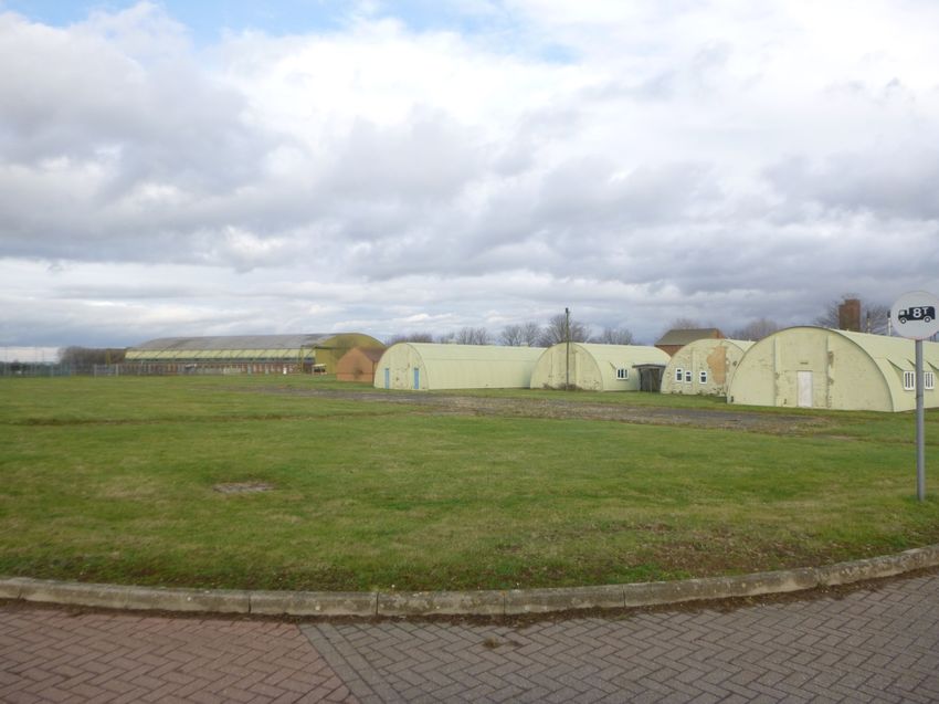
Waterbeach Heritgae Character Assessment

Prepared for: Locality                     AECOM
Waterbeach Heritage and Character
Assessment

1.           Introduction
This report presents a summary of the history and character of Waterbeach, a large village which lies within the
district of South Cambridgeshire. It has been prepared by consultants at AECOM on behalf of Locality, working
closely with the Waterbeach Neighbourhood Group and is based on a detailed appraisal of the area carried out
through desk study and fieldwork.

This report assesses both the heritage and landscape character of Waterbeach. Landscape character
assessment is a process used to describe and articulate what is special and distinctive about a particular place
by identifying recognisable patterns of elements or characteristics that make one landscape different from
another. Landscape is defined by the European Landscape Convention as “….. an area, as perceived by people,
whose character is the result of the action and interaction of natural and/or human factors.” This definition is
broad and encompasses natural, rural, urban and peri-urban areas.

The information generated through the process of characterisation can be used as evidence to support the
planning and design process. This approach is supported by the National Planning Policy Framework (NPPF),
which states that neighbourhood plans should develop robust and comprehensive policies based on an
understanding and evaluation of its defining characteristics (DCLG, 2012). In doing so, policies can ensure that
development responds to local character and history, and reflects the identity of local surroundings and materials,
while not preventing or discouraging appropriate innovation.

2.           Approach
The approach of this study follows well-established landscape character assessment techniques. A detailed desk
study and fieldwork carried out to inform this assessment underpins the classification and description of character
areas and broadly follows the process set out in the “Approach to Landscape Character Assessment” (Natural
England, 2014).This approach has been tailored to meet the specific needs of the neighbourhood planning
process and draws on further best practice guidance including:

•     Using Historic Landscape Characterisation (Historic England 2004);

•     Character and identity Townscape and heritage appraisals in housing market renewal areas (Historic
      England and CABE 2008);

•     Understanding Place Historic Area Assessments: Principles and Practice (Historic England 2010);

•     Townscape Character Assessment: Technical Advice Note 05/2017 (Landscape Institute, 2017); and

•     Historic Environment: Good Practice in Planning Note 3 (Historic England, 2017).

Historic England, previously English Heritage has issued a number of guidance and best practice notes covering
a range of issues in relation to the conservation and management of historic places and heritage assets all of
which are available on the Historic England website (https://historicengland.org.uk/advice/planning/).

This study is the result of desk based research and field work carried out in March 2018. The study builds upon
initial conversations carried out by the Waterbeach Neighbourhood Plan Group including outputs from a
workshop and accessing a number of publicly available resources materials.

3.           Context
This section of the report describes the location and context of Waterbeach and summarises current planning
policies which are relevant to the study.

3.1          Location
The village of Waterbeach is located approximately 9.7km north of Cambridge city centre as shown in Figure 1.
At the time of the last census in 2011 it had a resident population of 5,166 (ONS, 2011). The parish covers an

Prepared for: Locality                                                                                      AECOM
                                                                                                                7
Waterbeach Heritage and Character
Assessment

                         2
area of over 23.3km and is bounded to the east by the River Cam and the A10 to the west. The village lies
towards the south with the majority of the central and northern parts comprising open farmland, typically drained
Fenland. This land separates Waterbeach from the neighbouring settlements of Landbeach (1.75km to the west)
and Milton (3.5km to the south) and Upware (6km to the north). Waterbeach Barracks, formerly RAF Waterbeach,
lies along the western boundary of the parish.

Figure 1 Location and context

Contains Ordnance Survey Data © Crown Copyright and database right 2018. Reproduced from Ordnance Survey digital map
data © Crown copyright 2018. All rights reserved. Licence number 0100031673.

3.2          Planning Policy Context

3.2.1        National Planning Policy

The current National Planning Policy Framework is under review and a draft has been issued for comment. At the
time of writing the revised NPPF is expected to be adopted in summer of 2018. However until such time as its
adoption the current NPPF 2012 will remain relevant.

National Planning Policy Framework (NPPF), 2012

The NPPF requires local authorities to set out in their Local Plan a positive vision for the enhancement and
enjoyment of heritage assets (DCLG, 2012). Part 12 Conserving and enhancing the historic environment clearly
states that local authorities should recognise “the desirability of new development making a positive contribution
to local character and distinctiveness” and should seek “opportunities to draw on the contribution made by the
historic environment to the character of a place”. An understanding of history and heritage is therefore important
in developing neighbourhood plans, but to the extent that it informs future development and the contribution this
makes to local distinctiveness. These points are reinforced by a number of specific policies in the NPPF.

Prepared for: Locality                                                                                        AECOM
                                                                                                                  8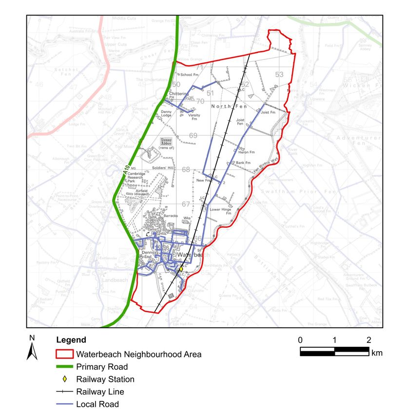
Waterbeach Heritage and Character
Assessment

Paragraph 58 states that neighbourhood plans should develop robust and comprehensive policies that set out
the quality of development that will be expected for the area, which are based on stated objectives for the future
of the area and an understanding and evaluation of its defining characteristics.

Paragraphs 60 is clear that promoting and reinforcing local distinctiveness is important, but that neighbourhood
plans should not attempt to “impose architectural styles or particular tastes” or “stifle innovation, originality or
initiative through unsubstantiated requirements to conform to certain development forms or styles”. Paragraph 61
goes further, stating that “although visual appearance and the architecture of individual buildings are very
important factors, securing high quality and inclusive design goes beyond aesthetic considerations”. It stresses
that planning policies should “address the connections between people and places and the integration of new
development into the natural, built and historic environment.”

The NPPF also includes guidance on developing policies to provide special protection for green areas through
Local Green Space designations. Criteria for such designations are provided in paragraph 77.

Planning Practice Guidance, 2014

Planning Practice Guidance was reviewed, catalogued and published on the internet by the government in 2014
(DCLG, 2014). The section on design includes guidance on promoting landscape character (Paragraph:
007Reference ID: 26-007-20140306). It states that “development should seek to promote character in townscape
and landscape by responding to and reinforcing locally distinctive patterns of development” and that the
“successful integration of new development with their surrounding context is an important design objective”.

3.2.2        Local Planning Policy

South Cambridgeshire Core Strategy, 2007

The Core Strategy (adopted 2007) sets out the over-arching vision and policies which govern development
across the district. The strategic vision recognises the need for the district to contribute to satisfying the
development needs of the Cambridge Sub-Region, while preserving and enhancing its rich built and natural
heritage and distinctive character.

Objective ST/e of the Core Strategy is to “protect the varied character of the villages of South Cambridgeshire by
ensuring that the scale and location of development in each village is in keeping with its size, character and
function and that the buildings and open spaces which create their character are maintained and where possible
enhanced.” This is further supported by objective ST/j which states that the Core Strategy will “ensure that the
district’s built and natural heritage is protected and that new development protects and enhances cherished
townscape assets of local urban design, cultural, and conservation importance, and character of the landscape.“

The Core Strategy also includes a number of key policies which are directly relevant to heritage and character.
These include:

•     ST/1 Green Belt – relates to an area south of the village where development is restricted to protect the
      landscape setting of Cambridge; and

•     ST/5 Minor Rural Centres – defines Waterbeach as a minor rural centre which provides services and
      facilities for the rural hinterland.

South Cambridgeshire Development Control Policies, 2007

This document sets out policies relating to sustainable development, design quality and development principles.
Those policies which are of most relevance to this heritage and character assessment include:

•     DP/2 Design of New Development - which includes a requirement that all new development must preserve
      or enhance the character of the local area;

•     DP/3 Development Criteria – states that planning permission will not be granted where the proposed
      development would have an unacceptable adverse impact on village character or on the countryside, and
      landscape character;

•     DP/4 Infrastructure and New Developments – requires some new development to make contributions to the
      preservation or enhancement of the historic landscape or townscape;

•     GB/1 Development in the Green Belt – includes an assumption against inappropriate development in the
      Cambridge Green Belt;

Prepared for: Locality                                                                                        AECOM
                                                                                                                  9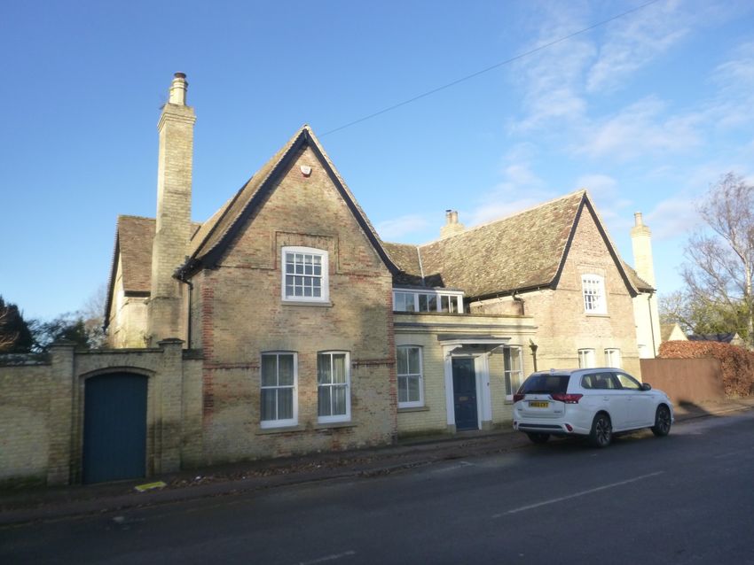
Waterbeach Heritage and Character
Assessment

•     GB/2 Mitigating the Impact of Development in the Green Belt – requires any development considered
      appropriate within the Green Belt to be “located and designed so that it does not have an adverse effect on
      the rural character and openness of the Green Belt.”

•     GB/5 Recreation in the Green Belt – encourages proposals for the appropriate use of the Green Belt for
      increased or enhanced opportunities for access to the open countryside;

•     HG/6 Extensions to Dwellings in the Countryside – sets out criteria for the design of extensions to existing
      buildings;

•     SF/9 provides protection of existing recreation areas;

•     SF/10 includes a requirement for new outdoor play space, informal open space in new developments;

•     SF/12 states that the District Council will only permit extensions to the curtilage of existing marinas or
      boatyards, or new marinas and boatyards if development would not have an adverse impact on the
      landscape and character of the River Cam corridor;

•     NE/4 Landscape Character Areas - Development will only be permitted where it respects and retains or
      enhances the local character and distinctiveness of the individual Landscape Character Area in which is it
      located;

•     NE/5 Countryside Enhancement Areas - Any development which would materially affect a Countryside
      Enhancement Area will be expected to mitigate its impact, or enhance the area, as part of the planning
      proposal.

•     CH/1 Historic Landscapes - Planning permission will not be granted for development which would adversely
      affect or lead to the loss of important areas and features of the historic landscape whether or not they are
      statutorily protected;

•     CH/3 Listed Buildings - the District Council will adopt a presumption in favour of the retention and
      preservation of local materials and details on Listed Buildings in the district;

•     CH/5 Conservation Areas – refers to guidance contained in specific Conservation Area Appraisals (where
      they exist) and the District Design Guide;

•     CH/6 Protected Village Amenity Areas – states that development will not be permitted within or adjacent to
      Protected Village Amenity Areas if it would have an adverse impact on the character, amenity, tranquillity or
      function of the village. These areas are located within the Waterbeach conservation area and include public
      open space as well as private residential gardens;

•     CH/7 Important Countryside Frontages - Important Countryside Frontages are defined where there is land
      with a strong countryside character;

•     CH/9 Shop Fronts - The District Council will only grant planning permission for shop fronts and alterations to
      existing shop fronts which create a fascia and shop window which is in character with the building itself and
      the street scene.

•     SS/5 In the emerging Local Plan (at examination stage at the time of writing) includes an allocation at the
      site of the former Waterbeach Barracks to allow for 8,000 to 9,00 0 dwellings and associated users.

A new Local Plan for South Cambridgeshire is currently in preparation, but has been delayed following an
examination in public. This will eventually replace the 2007 Adopted Development Plan, covering the period until
2031.

This report builds on a number of studies and planning documents relevant to Waterbeach, as shown below:

Development Affecting Conservation Areas SPD, 2009

This Supplementary Planning Document (SPD) builds on policies set out within the Development Control Policies
described above, including details on how they will be implemented. It covers extensions to existing buildings,
infill sites where gap sites in villages may be large enough to accommodate some new development, and
backland development, where land is proposed for development within existing plots. The document provides
detail on how to consider appropriate scale, massing, form and detailing and the choice and use of materials.
This SPD has been considered in preparing the principles for managing change described at the end of this
report.

District Design Guide SPD, 2010

Prepared for: Locality                                                                                             AECOM
                                                                                                                       10
Waterbeach Heritage and Character
Assessment
The District Design Guide is intended to ensure the delivery of sensitively and appropriately designed,
sustainable developments. It provides further details and guidance to support the policies set out in the
Development Control Policies document. The information which is directly relevant to this heritage and character
assessment comprises the following:
• Village landscape and settlement analysis;
• Urban design principles
• Appreciating the context (including landscape setting); and
• Elements of design.
3.2.3 Historical Development
The marshes surrounding present day Waterbeach had been settled during the Roman period, and evidence of
Anglo-Saxon pottery near the Car Dyke suggest settlement in the area during the early medieval period. The
village of Waterbeach most likely originated late in the early medieval period, and was well stablished by the
Domesday survey of 1086. Waterbeach derives its name from its location on a ridge or beche. Its name
distinguishes it from its neighbouring settlement of Landbeach by its close proximity to the water of the River
th
Cam. Recorded as Bechia before 1086, by the 13 century it was known as Waterbeche. For much of its history
Waterbeach can be defined as a typical southern Fenland village, dominated by an agricultural character and
th
way of life. Limited expansion and rebuilding during the 19 century, while confined to the medieval and post-
medieval street pattern, dominates the present day character and appearance of the historic core.The
construction of an RAF airfield north of the settlement from 1939 offered new employment opportunities, and
th
encouraged the growth of Waterbeach throughout the remainder of the 20 century. This has been manifested in
the development of residential estates on the periphery of the historic core.
Prepared for: Locality AECOM
11Waterbeach Heritage and Character
Assessment
e 2 Street Plan
Contains Ordnance Survey Data © Crown Copyright and database right 2018. Reproduced from Ordnance Survey digital map
data © Crown copyright 2018. All rights reserved. Licence number 0100031673.
3.3 Timeline
3.3.1 Medieval
1086 – Waterbeach is well established as a small agricultural settlement.
1150 – Benedictine monks establish an abbey at Denny (Danes’ Isle), in the empty high ground north of
Waterbeach, to become known as Denny Abbey.
1170 – Until 1308 Denny Abbey is occupied by the Knights Templar.
1200 – St John The Evangelist Church is established as a small aisled church, two arcade bays of which survive.
1279 – c.180 tenants and 68 messuages are recorded in the parish.
1293 – Common Fenland north of the village is formally divided between Waterbeach and Stretham.
1294 – A second abbey was established south of the village by nuns of the Second Order of St Francis, now
known as Waterbeach Abbey.
1341 – Until the dissolution, Denny Abbey was occupied by Franciscan Nuns after abandoning their flood prone
abbey located to the south of the village.
th
1350s –By the mid-14 century a number of streets are developed orientated east off of what is now the High
th
Street forming the basic plan of the historic core of the village. Prior to changes from the 19 century, houses in
the village are largely laid out along the High Street, widening at the village green.
1377 – 205 adults are recorded as paying the Poll Tax.
1524 – Only 31 adults are recorded as paying the Poll Tax.
3.3.2 Post-medieval
1686 – A single inn is recorded in the village.
1740 – A commission is set up for the levying of funds to drain the fens in the north of the parish. A windmill is
built soon after to pump water from the Fenland.
1763 - Under the Cambridge-Ely Turnpike Act a new road is laid out along the Landbeach boundary. The Car
Dyke becomes the primary route into the village.
1766 – A second windmill is established in the parish.
1779 – An annual village feast is recorded as being moved as to not interrupt with harvest. The feast is held until
1939 and then reduced in scale up until the 1960s.
1790s – Activities and sports are recorded as traditionally undertaken on the village green, however this has
ceased by 1820.
1797 – The Sun and Whitehorse public houses are established by this time.
1797 - The Waterbeach Level Commissioners begin levying tolls on people using the Cam’s flood banks for
horses hauling barges.
3.3.3 19th century
1800 – Fen pasture dominates the eastern half of the parish
1801 – Waterbeach’s population is recorded as 553 in 129 households.
1814 – An Inclosure Act is passed, removing rights of access to formally common land and creating field
boundaries. Before this time the only settlement in the parish outside of the village was at three farms at Denny
Abbey, Causeway End Farm on Elmey Islet and North Hill Farm.
Smallholders that prospered rebuilt their homes; replacing traditional timber framed and reed thatch with grey
brick houses in square plan.
1814 – A public wharf is built near Bottisham Lock on the River Cam, for the use of local landowners.
1830s – Steam engines replace watermills used to drain the Fenland.
1831 – The population is recorded as c.1065.
1839 – A Parochial Village School is established at Greenside.
1840s-1870s – Emigration to America and Australia reduces the population?
1845 – The Great Eastern Railway constructs their main route through the Parish, establishing a station at
th
Waterbeach by 1851. Water borne transport remained important into the late 19 century.
Prepared for: Locality AECOM
12Waterbeach Heritage and Character
Assessment
1850 - Waterbeach has 10 inns and public houses.
1850s – Waterbeach’s population is recorded as 1440, but was impacted by a typhoid outbreak in 1849 and
cholera in 1854.
1860s – 65-70 houses are recorded in the former fens. 24 are farmhouses. Properties are laid on the straight
roads through the Fenland which were developed after 1814.
1860s – Flower and vegetable shows are established in the village by the Waterbeach Horticultural Society.
1866 – The Waterbeach Gas Works are established, bringing in coal by rail.
1871 – For a time the population peaks at 1619 before declining.
1886 – The Waterbeach Baptist Chapel is shown on the first edition Ordnance Survey map.
1895 – Following cutting off of the village gas supply after being offended by a skimmington, the owner of the gas
works loses his contract with the railway and the works subsequently closed.
3.3.4 20th century
1901 – The population is recorded as 1277.
1939 – Almost 700 acres of farmland north of the village is requisitioned by the RAF for the construction of an
airfield.
1944 – At the height of the war, RAF Waterbeach housed 2600 people.
1951 – The arrival of RAF Waterbeach had encouraged the growth of the town, with 2630 inhabitants recorded in
the census of 1951 with 1880 from the civil population.
1952 – Although density of the grain of development has increased, Waterbeach’s street pattern has changed
th
little since the mid 19 century and still reflects the medieval layout in the centre of the village.
1966 – RAF Waterbeach is transferred from the RAF to the Royal Engineers, to become known as Waterbeach
Barracks.
1971 – The annual village feast is revived.
1970 – Historic maps show residential development has taken place to the north and east of the historic core,
centred in Way lane and Denny end Road.
1975 – Waterbeach largely reaches its current size, with the exception of small number of residential
developments since.
1981 – Of 3800 permanent residents in the village, 3551 are civil population.
2013 - Waterbeach Barracks is closed.
3.3.5 Present
Waterbeach today largely comprises modern housing estates, of mixed tenure including three or four bed
detached, semi-detach and terrace properties, built from the post-war period to the present. Their architectural
details show limited local influences preventing them from contributing to the distinctiveness of Waterbeach.
These are distinct from the historic core of the village which is generally well preserved. With the closure of the
Waterbeach Barracks in 2013 Waterbeach relies heavily on commuter employment, with the greatest
employment opportunities found in Cambridge and some in the modern Denny Industrial Estate developed to the
west of the village.
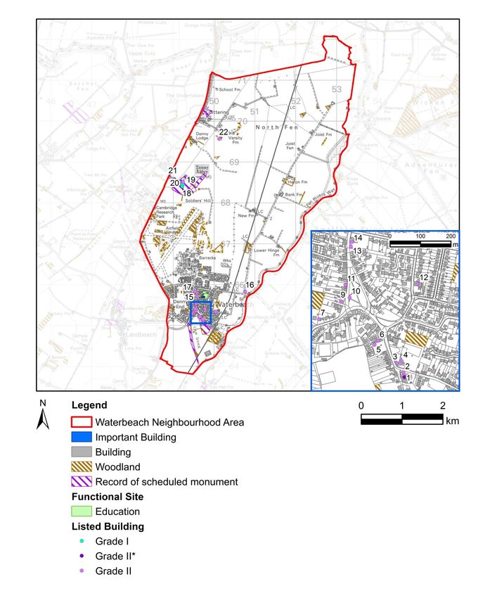
3.3.6 Scheduled Monuments
There are four scheduled monuments in the neighbourhood plan area; these include Denny Abbey (NHLE
1012770), Waterbeach Abbey (site of) (NHLE 1006888), Car Dyke (NHLE 1006930) and Romano-British
Settlement at Chittering (NHLE 1012359).
3.3.7 Listed Buildings
A total of 19 listed buildings are located within the neighbourhood plan area (see Figure 6), of these a single
example is considered of more than special interest and has been designated as grade II* listed. This comprises
th th
the St John The Evangelist Church, built from c.1200 with later phases dated to the 13 and 15 centuries. The
tower and spire were rebuilt after collapse in 1821. Successive enlargement and restorations followed later in the
century. The remaining 18 listed buildings are all of special interest and are designated as grade II. These largely
reflect the rural domestic and agricultural character of the historic core of the village. Notable examples include:
Prepared for: Locality AECOM
13Waterbeach Heritage and Character
Assessment
th
The Hall (NHLE 1127364), a farmhouse dated to the 17 century; Barn to south-west of Orchard House (NHLE
th
1179631) is a timber framed and weather boarded barn dated to the 17 century; and Denny House, a timber
th
framed former farmhouse with gault brick extensions, with origins in the 16 century.
3.3.8 Conservation Areas
The historic core of Waterbeach is largely covered by the Waterbeach Conservation Area, originally registered in
1973 in recognition of the special architectural and historic interest of the area the character or appearance of
which is to be preserved or enhanced. A conservation area appraisal was written in 1999, although never
adopted. This interest is derived from the prevalence of historic fabric which survives in the core of the village,
and the development of the village from the medieval period which is apparent in that fabric. A total of 15 of the
Neighbourhood Plan Area’s listed buildings are located within the conservation area including the Grade II* listed
St John The Evangelist Church, the remaining being Grade II. The conservation area covers the majority of the
historic area of the village at the time of the 1901 Ordnance Survey map, with only five grade II listed buildings in
the neighbourhood plan area are not included within the boundary of the area. Within the village these include 31
Burgess Road (NHLE 1331327) and Box Tree Cottage (NHLE 1179660), both of which are timber framed and
th th
dated to the 17 and 18 centuries respectively.
3.3.9 Landscape Designations
Statutory and non-statutory landscape designations have been reviewed to determine the levels of protection
currently given to the landscape within the Waterbeach study area.
The Waterbeach Conservation Area affords protection to buildings and the surrounding townscape (Policy CH/5).
Protected Village Amenity Areas (Policy CH/6) are located throughout the centre of the Waterbeach along High
Street, south towards the railway station along Station Road and for a small portion of Cambridge Road. A large
part of the southern edge of Waterbeach is designated as Green Belt (Policies ST/1, GB/1, GB/2 and GB/3)
restricting development and the expansion of the village south. In addition on the eastern boundary lies Cam
Washes a Site of Special Scientific Interest (SSSI).
3.3.10 Existing Landscape Character Assessment
Existing character assessments have been reviewed to provide some context to this more detailed assessment.
The study area spans two National Character Areas (NCA), as defined by Natural England (Natural England,
2014). NCA 88: Bedfordshire and Cambridgeshire Claylands covers a small area on the western edge of the
parish, including much of the Waterbeach Barracks (See Figure 2). The majority of the parish is covered by NCA
46: The Fens, which extends across the northern and eastern areas of the parish. NCAs are broad but provide
some context to the character of the study area.
Natural England defines key characteristics as “those combinations of elements which help to give an area its
distinctive sense of place” that would result in significant consequences for the current character if they were
changed or lost. As a result, they form important evidence to support the development of planning and
management policies and a reference point against which to monitor change.
The key characteristics of NCA 88 which are of particular relevance to this assessment are:
• Predominantly open, arable landscape of planned and regular fields bounded by open ditches and trimmed,
often species-poor hedgerows which contrast with those fields that are irregular and piecemeal;
• Diversity of building materials including brick, render, thatch and stone;
• Smaller towns, villages and linear settlements widely dispersed, giving a rural feel; fen-edge villages are
often in a linear form along roads.
The key characteristics of NCA 46 which are of particular relevance to this assessment are:
• Expansive, flat, open, low-lying wetland landscape offering extensive vistas to level horizons and huge
skies, providing a sense of rural remoteness and tranquillity;
• Woodland cover is sparse;
• The predominant land use is arable; and
Prepared for: Locality AECOM
14Waterbeach Heritage and Character
Assessment
• Open fields, bounded by a network of drains and the distinctive hierarchy of rivers (some embanked), have
a strong influence on the geometric/rectilinear landscape pattern.
There is no published landscape character assessment for South Cambridgeshire District, although there are a
number of documents at the local level which reference to landscape character.
The Cambridge Green Belt study, published in 2002, also includes the part of the study area covered by Green
Belt. This is defined as Waterbeach-Lode Fen Edge (1A), a transitional landscape type situated between the
Fens and the higher land beyond. It is relatively low-lying and appears generally flat with agricultural land uses,
roads and settlements. Fen Edge has traditionally been an important location for settlement, above the floodplain.
There is access to wetlands and higher land suitable for agriculture. Building materials in Fen Edge villages
include gault brick, render and thatch.
The South Cambridgeshire District Design Guide SPD includes a landscape character overview. This identifies
Waterbeach as lying within the Fen Edge, which is described as a mostly flat, low lying landscape with open
views. Linear ‘lodes’, drains and droves running north-south form distinctive features of the character area. Large
skies, a hierarchy of streams and ditches, rich and varied intensive agricultural land with a range or arable and
horticultural crops are distinctive. Small scale medieval field patterns are still visible around the edge of the
settlement. Low lying sand and gravel fen ’islands’ rise above the surrounding flat landscape and have provided a
historic focus for settlements.
Settlement Character is described as:
• Strong linear form, often developed outwards from crossroads along approach roads;
• Within historic cores narrow lanes with continuous street frontage are typical;
• Buildings are often set back with low lying walls and hedges fronting the streets;
• Long back gardens are a common feature;
• The rich and varied intensive agricultural land use includes a wide range of arable and horticultural crops
and livestock;
• Large skies, which create drama; and
• Groups of buildings on or close to the back of the pavement in the village.
4. Character Assessment
4.1 Key Characteristics
Waterbeach predominantly falls into three distinct areas: Waterbeach Barracks, the rural central and northern
area and the Waterbeach Village as defined below.
Waterbeach Barracks
Photograph 1 Waterbeach Barracks
Prepared for: Locality AECOM
15Waterbeach Heritage and Character
Assessment
Waterbeach Barracks key characteristics:
• West of the former airfield lies flat, open and unmanaged rural-fringe landscape with a handful of small
single storey buildings. A number of mixed woodland blocks and conifer plantations are located to the east
of the former airfield, with more sporadic woodland cover in the west;
• A large, well-established lake with evidence of a diverse flora, including reed beds and woodland;
• Distinctive, tall bunds and tree belts line the western boundary, enclosing the Barracks and preventing
views and access from the adjacent A10;
• Large trees within large areas of grass create an strong sense of being in an estate with the occasional
ornamental shrub planting to building frontages;
• Buildings within the barracks are arranged on a geometric grid layout and large scale urban grain. Former
aircraft hangers and three storey buildings used as barracks are set back within large plots, with large areas
of amenity grassland to their frontages and the occasional individual trees;
• Individual and small groups of trees are dispersed throughout the amenity space within the south eastern
corner. A large area of amenity green space defines the main entrance from Denny End Road and an
avenue of cherry trees lines the drive
Waterbeach Village
Photograph 2 – Waterbeach Green Side
Key characteristics:
• A rich quality of historic houses demonstrating a range of architectural styles, particularly along the long
Green Side which encircles the central village green. This is also true of a number of buildings leading from
Green Side to St John The Evangelist Church along Station Road;
Prepared for: Locality AECOM
16Waterbeach Heritage and Character
Assessment
• Attention to architectural detailing is common in older buildings, which is a reflection of the wealth of the
th th
area in the 18 and 19 centuries. Some styles and features have been replicated in more recent
developments to reinforce the character of Waterbeach;
• Urban grain is finer in the centre where the buildings are generally more intricate and plots are narrow and
long;
• A noticeable characteristic of older buildings is the presence of garden walls and hedges to the fronts of
properties. This is replicated in only a few recent developments;
• Most buildings are two storeys in height, are detached or semi-detached and constructed in distinctive local
buff gault brick with slate or tiled shallow pitched roofs. A small number of buildings have thatched roofs;
• The edges of the green at the centre of the village and conservation area is defined by an avenue of mature
lime trees;
• Mature trees in rear gardens contribute strongly to the street scene, particularly in the absence of significant
areas of public open space or street trees;
• Timber finger sign posts are used throughout the conservation area, which assists in wayfinding and
reinforces the historic character of the village core;
• Waterbeach railway station is located to the south east of the village on a route which is known as the Fen
Line. The railway provides connections to national rail services to London King’s Cross to the south via
Cambridge and to King’s Lynn to the north. This has supported Waterbeach’s growth as a commuter
settlement.
Central and Northern Rural Area
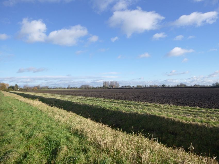
Photograph 3 – From Long Drove showing the rural character of part of Waterbeach
Key characteristics:
• Flat, open, arable landscape surrounding the village to the north, with very little settlement;
• Strong sense of remoteness and isolation and huge open skies;
• Field boundaries and layout are defined by a network of deep agricultural drainage channels which link to
the River Cam in the east. The boundaries contain occasional trees or short stretches of unmanaged
hedgerow;
Prepared for: Locality AECOM
17Waterbeach Heritage and Character
Assessment
• To the east is a well vegetated riparian corridor, which follows the River Cam and forms a backdrop to the
predominately agricultural landscape.
As set out above, the character of the landscape is the result of the action and interaction of a range of natural
and / or human factors. These are considered in turn below in relation to the neighbourhood plan area.
4.2 Natural Factors
4.2.1 Geology and Soils
The underlying geology of an area is often largely hidden from view but has a strong influence on its character,
having been shaped over by natural processes including erosion and sedimentation over millions of years. These
process help to define the landform, soils, vegetation, drainage and building materials which are common in an
area.
Two distinct bands of bedrock underlie orientated broadly south-west to north-east (British Geographical Survey
2018)
• Gault Formation – Mudstone, Sedimentary Bedrock formed approximately 100 to 112 million years ago in
the Cretaceous Period. The local environment was previously dominated by shallow seas; and
• Wobrun Sands Formation – Sandstone, Sedimentary Bedrock formed approximately 100 to 125 million
years ago in the Cretaceous Period. The local environment was previously dominated by shallow seas. The
majority of Waterbeach is located over this bedrock.
The underlying bedrock strongly influences the pattern of soils within the study area (Soilscape, 2018). There are
five main soil types comprising:
• Soilscape 5: Freely draining lime rich loamy soils
• Soilscape 9: Lime-rich loamy and clayey soils with impeded drainage
• Soilscapes 20: Loamy and clayey floodplain soils with naturally high groundwater
• Soilscapes 23: Loamy and sandy soils with naturally occurring high ground water and peaty surface
• Soilscapes 27: Fen peat soils with cultivated soils drained into ditches with shallow ground water
These biological qualities of soil structure its fertility coupled with the accessibility of the flat landform contribute to
the extensive areas of agriculture which accounts for the majority of the land uses at Waterbeach.
4.2.2 Topography and Hydrology
The topography of the study area has a strong influence on the character and setting of the village of Waterbeach
(See Figure 3). The majority of the land within the parish is low-lying. North of the village, most of the land is at or
just above sea level at 2m Above Ordnance Datum (AOD). The land here is flat or very gently undulating as a
result of the historic draining of the Fenland. This gives rise to huge open skies and long distance views in the
rural landscape.
The village of Waterbeach sits upon an area of slightly higher ground, which lies between 8m and 11m AOD. This
localised high point is not perceptible within the village or on the approach from neighbouring villages, including
from the A10. The landform is consistent with the topography of the wider area, which rises in the south west
towards Cambridge at 14m AOD and falls to the north east to 2m AOD at Upware.
The historic, man-made Car Dyke lies at the south western edge of the parish. This distinctive topographical
feature is an eighty mile water channel, thought to have been constructed by the Romans from the first century
AD. The Dyke runs along the western edge of the fens from River Cam near Cambridge all the way to River
Witham, just south of Lincoln. It is evident in the landscape to the south of Car Dyke Road, but overwritten by
development and modern agriculture to the north.
Agricultural field drains flow east towards the edge of the parish where they enter the River Cam, which
meanders along the eastern boundary of the parish. The River Cam flows north where it meets the Great Ouse,
which in turn flows into the North Sea at King’s Lynn. In the rural central and northern areas of the parish the
drains exert a strong influence on the structure of the landscape, evident in the field patterns and the network of
roads and footpaths which traverse the area.
Prepared for: Locality AECOM
18Waterbeach Heritage and Character
Assessment
Figure 3 Topography and hydrology
The above figure Contains Ordnance Survey Data © Crown Copyright and database right 2018. Reproduced from Ordnance Survey digital map
data © Crown copyright 2018. All rights reserved. Licence number 0100031673.
4.3 Cultural Factors
4.3.1 Land Use and land-cover
The dominant land use within the parish is principally agricultural. Large-scale arable fields are common,
particularly in the drained Fenland in the north and east. Historic names, such as Fidwell Fen, North Fen and Fen
Rivers Way have survived until the present day. Whilst hedgerows and trees often follow the routes of droves,
they are generally absent along field boundaries and this increases the sense of openness, remoteness and
Prepared for: Locality AECOM
19Waterbeach Heritage and Character
Assessment
isolation. Remote, isolated farms and agricultural buildings are present within the rural northern and central parts
for the parish set within large agricultural fields.
In the rural areas of the parish woodland is almost entirely absent and trees are sporadic. There are some small
blocks of woodland within the Waterbeach Barracks, comprising mixed broadleaved woodland and coniferous
plantations. Cow Hollow Wood is a small community woodland in the south east of the parish and makes the
largest single contribution to woodland cover. Field drains and boundaries are largely devoid of vegetation with
only small groups of shrubs, hedgerows or trees represented within the landscape. In contrast, the River Cam
contains linear tree belts providing riparian vegetation, such as Willow, enclosing sections of the River Cam.
Other land uses within the rural landscape include a disused golf course associated with the barracks to the north
of the village.
Waterbeach contains a range of land uses, from predominantly residential in the village, with commercial areas
military uses on the periphery of the settlement. Agricultural land uses making up the largest land use in the study
area at the rural areas. Upware and Chittering lie north of Waterbeach and consist of a collection of a small
number of residential buildings and farmsteads. Upware is located on the River Cam and has a marina and a
loch. The River Cam is home to a number of water based clubs such as the Cambridge Motor Boat Club and
Cam Sailing Club.
A Romano-British settlement at Chittering in the north of the study area hosts a series of earthworks representing
remains of a substantial farming settlement dating back to the Roman period. The site lies south of the A10 and
contains findings of pottery, house foundations and crop marks indicating the full extents of this settlement. This
shows a strong historical reference to settlements in Waterbeach giving a rich built heritage to the parish.
Waterbeach Barracks would have added to the rich diversity of land uses at Waterbeach as a former military
base. This characteristic in itself is typical of the region, as East of England was home to several airfields now
largely retired or redeveloped. The airfield served as base command in the Second World War and offered
community facilities to the local people of Waterbeach. Now the site is closed to the public with a small portion of
the site still in use mainly to house military personnel. The majority of the site has been derelict since 2013 with
the exception of squash courts, tennis courts and a small museum.
Photograph 4 -The above image is from Waterbeach Barracks facing north-east at a point adjacent to the
southern part of the runway.
Prepared for: Locality AECOM
20Waterbeach Heritage and Character
Assessment
In the village the majority of dwellings are in a well maintained condition, with few areas of the parish containing
dwellings suffering from poor maintenance or neglect. The parish contains a range of residential estates with
well-kept buildings including roofs, chimneys and facades. Front gardens are well maintained with mown grass
and trimmed hedgerows. The public open space is clearly well used with no signs of littering and few examples of
graffiti or vandalism.
The business park at Pembroke Avenue on the western edge of the village is occupied by a wide range of
businesses, including a brewery, a taxi company, a sign builders, a laser cutting metal fabricators and many
more. Some have global connections with companies such as Samsung and provide services to range of local
and global markets giving a strong economy to Waterbeach.
Waterbeach Barracks is currently an ex-military site with only a small number of buildings on site still in use, to
house military personnel. The site contains large number of aircraft hangers, golf course, swimming pool and
warehouses as well as big areas of hard surfacing. The majority of the ex-military base has been left unmanaged
since 2013.
Figure 4 Landscape designations
Contains Ordnance Survey Data © Crown Copyright and database right 2018. © Natural England material is
reproduced with the permission of Natural England 2018.
Prepared for: Locality AECOM
21Waterbeach Heritage and Character
Assessment
4.3.2 Movement and Connectivity
The primary route into Waterbeach is via the A10, which follows the full length of western boundary of the parish.
This historic route, which is now a trunk road, links central London with King’s Lynn on the north Norfolk coast.
There are two access points from the A10 into Waterbeach. There is a signalised junction where the single-
carriageway A10 meets Denny End Road, which often causes congestion at peak times. Denny End Road enters
the village at the northern end providing access to Waterbeach Barracks and the top of the High Street. Entering
the village at the southern end is Car Dyke Road in the west and Clayhithe Road in the east forming a single road
and passing Green Side at the centre of the village. Off-street parking is rare in the centre of the village, leading
to an abundance of on-street parking, which slows traffic passing through the village. This is also true of Station
Road, which is susceptible to long queues of traffic where cars are parked on the road forcing vehicles to wait
and pass one at a time. A common feature of modern estates is cul-de-sacs, such as Hartley Close. There are
few connections between neighbouring estates, which reduces legibility and permeability and discourages
community interaction. A bus service operates from the centre of the village at Green Side to the centre of
Cambridge as well as nearby settlements. Green Side is a focus of activity as the majority of traffic passes
through this central point of village, where local services such as shops are located.
The rural roads are broadly straight and level with the surrounding landscape. Routes north of village through the
open agricultural landscape are generally limited to narrow ‘droves’, such as Burgess’s Drove, most of which are
unmade private tracks which stop at isolated farms.
A small number of Public Rights of Way cross the conservation area and link Green Side to the rural landscape to
the west and to the north, extending out into North Fen. Timber finger sign posts within the conservation area
enhance wayfinding through the village. Fen Rivers Way and National Cycle Route 11 both follow the tow path of
the River Cam, providing recreational routes to Cambridge and Ely. Public rights of way are otherwise scares and
large tracts of Fenland in the north and the former Barracks site are not publicly accessible for this reason.
Waterbeach railway station is located to the south east of the village on a route which is known as the Fen Line.
This route provides connections to national rail services to London King’s Cross to the south via Cambridge and
to King’s Lynn to the north, sustaining Waterbeach’s as a commuter settlement. The railway line crosses three
roads on the eastern edge of the village at Bannold Road, Burgess Road and Clayhithe Road. All have a
heightened sense of departure from the village to rural countryside and forms gateways to Waterbeach.
Prepared for: Locality AECOM
22Waterbeach Heritage and Character
Assessment
Figure 5 Movement and connectivity
The above figure contains Ordnance Survey Data © Crown Copyright and database right 2018. Reproduced from Ordnance Survey digital map
data © Crown copyright 2018. All rights reserved. Licence number 0100031673.
4.3.3 Settlement and built form
Historical road layouts in the centre of the village have created a fine urban grain in contrast to the more coarse
urban grain found at the barracks and the business park at Pembroke Avenue. Green Belt has curtailed
expansion of residential development in the south. As a consequence, modern residential expansion is
concentrated on the northern and eastern edge of the village.
Buildings throughout the village are mainly residential two storeys with occasional single storey buildings such as
the bungalow on No. 35 Rosemary Road. There is a mixture of detached, semi-detached and terraces houses
which create a varied streetscape. Few larger buildings existing with the exception of religious buildings such as
Waterbeach Baptist Church and St John The Evangelist Church, creates little variation of scale and massing to
the village. Commonly voids are created between non-terraced houses often providing rear access and/or private
driveways.
Buildings which line parts of the High Street in the north of the conservation area are set within large plots with
front gardens and frontages setback from the road. In contrast buildings at the southern end of the High Street
Prepared for: Locality AECOM
23You can also read