CHANGES OF DISPERSED SETTLEMENTS IN RURAL CULTURAL LANDSCAPE FROM THE STRATEGIC PERSPECTIVE WITH SPECIAL ATTENTION TO THE VILLAGE HRUŠOV IN ...
←
→
Page content transcription
If your browser does not render page correctly, please read the page content below
FOLIA GEOGRAPHICA • ISSN 1336-6157 (hard copy) • ISSN 2454-1001 (online)

        CHANGES OF DISPERSED SETTLEMENTS IN RURAL
        CULTURAL LANDSCAPE FROM THE STRATEGIC
        PERSPECTIVE (WITH SPECIAL ATTENTION
        TO THE VILLAGE HRUŠOV IN CENTRAL SLOVAKIA)

           Ján HANUŠIN A*, Mikuláš HUBA B, Vladimír IRA C
           Received: April 28, 2020 | Revised: September 15, 2020 | Accepted: November 8, 2020
           Paper No. 20-62/2-566

        Abstract
        The aim of this paper is to analyse changes of dispersed settlements in rural
        cultural landscape in municipality Hrušov (in the Krupinská planina plateau,
        Central Slovakia) with special focus on the development strategies applied in
        an effort to escape marginality. The area outside the core of the village is the
        unique dispersed settlement system with some specificities in rural development
        which are typical for marginal regions of Slovakia with such a type of settlement.
        The study deals with the development trends of the rural cultural landscape in
        the years 1950, 1986 and 2016 in the context of landscape changes in Slovakia.
        Attention is paid to marginality of the studied area, paradoxes and possibilities of
        its development and to the monitoring of the dispersed settlement developments
        in the light of local, regional, national and international documents. Diversified
        activities accomplished by the municipal authority, important local leaders and
        amenity migrants can serve as worth to follow example of how to restore care
        for a cultural landscape with dispersed settlements and how to eliminate the
        negative phenomena associated with the marginality status.
        Key words
        Rural cultural landscape, dispersed settlements, marginality, development
        programmes and documents, village Hrušov (Veľký Krtíš district).

INTRODUCTION AND OBJECTIVES
Despite the continuing concentration of population in compact (clustered) settle-
ments, the dispersed (scattered) settlements are still present in various forms in
most parts of the world. A dispersed settlement with its residential and landscape
structure, distinctive building and social and cultural peculiarities, has created
unique manifestations of material and spiritual heritage and genius loci. A land-
scape with dispersed settlements represents in most regions across Europe a spe-

A*   Institute of Geography, Slovak Academy of Sciences, Štefánikova 49, 814 73 Bratislava,
     Slovakia, hanusin@savba.sk (corresponding author)
B Institute of Geography, Slovak Academy of Sciences, Štefánikova 49, 814 73 Bratislava,
     Slovakia, mikulas.huba2@gmail.com
C    Institute of Geography, Slovak Academy of Sciences, Štefánikova 49, 814 73 Bratislava,
     Slovakia, geogira@savba.sk

106 • Folia Geographica, Volume 62, No. 2, 106–132, (2020)
Ján HANUŠIN, Mikuláš HUBA, Vladimír IRA

cific type of rural landscape that has experienced a significant change in the late
twentieth and the early twenty-first century.
    Social and technological modernization has affected almost all areas of the
rural life. Rural restructuring has produced causally linked effects across a multiplic-
ity of sectors with consequences that are qualitative as well as quantifiable (Woods
2005).
    Huba (1989) states that a dispersed settlement only meant the relocation of
a part of population to remote and unsuitable parts of the cadastre and that, to
some extent, it always constituted an extreme and emergency settlement pattern.
In spite dispersed settlements across Slovakia cannot be perceived as a marginal
phenomenon. Municipalities with this form of settlement occupy 4,640 km2, i.e.
about 10% of the area of Slovakia (Verešík 1974). The above mentioned author
identified 166 villages with dispersed settlements in 1961 where about 140,000
people (3.3% of the total population) lived in approximately 2,900 hamlets. Almost
the same number of the population lived in these villages in 1991 (Spišiak 1998)
which was 2.6% of the total population. Špulerová et al. (2017) identified the occur-
rence of functioning historical structures of agricultural landscape with dispersed
settlements in Slovakia on an area of 21,298 ha, which is about 1% of the area of
agricultural land. As an indirect comparison, information may be given that while
almost 12% of the Spanish population lived in dispersed settlements in 1960, it
dropped to 7% in 1980 (Amate et al. 2016).
    The regional names of dispersed settlement patterns in Slovakia do not reflect
their size or morphological characteristics (kopanice, lazy, štále, Verešík, 1974).
Although the terminology is not consistent even between the UK and the USA, the
individual hierarchical levels of dispersed settlement are sometimes more precise-
ly distinguished there, e.g. isolated farmsteads, hamlets and scattered dwellings
in UK, (Bibby & Brindley, 2013). Therefore, it was important to choose the English
equivalent for the Slovak term laz used in the studied region, which refers to an
isolated group of houses representing the basic unit of the dispersed settlement
system. As the closest term to the Slovak term laz, we chose the term hamlet in the
sense of Roberts (1996), which is defined as a settlement unit of 3-8 farmsteads
located 250 m apart from each other, which best corresponds to the settlement
pattern of the study area, while recognizing the differences arising from different
historical, cultural-economic and physical-geographical environment.
    The Hrušov dispersed settlement area along with the most of the regions with
dispersed settlement in Slovakia belongs to the so-called cumulative peripheral-
ity/marginality regions defined on the basis of four groups of indicators: human
resources, economic potential, household amenities, and accessibility of economic
centres (Halás 2008, Halás and Hurbánek 2008). The availability of labour, ed-
ucation, services and transportation significantly influences the quality of life in
such regions. The supply of job opportunities and services is not sufficient, and

                                     Folia Geographica, Volume 62, No. 2, 106–132, (2020) • 107
CHANGES OF DISPERSED SETTLEMENTS IN RURAL CULTURAL LANDSCAPE
                           FROM THE STRATEGIC PERSPECTIVE (WITH SPECIAL ATTENTION
                                 TO THE VILLAGE HRUŠOV IN CENTRAL SLOVAKIA)

particularly young and well-educated people often respond by emigrating. On the
other hand, in some such regions we surprisingly find specific features of human
and social capital (active mayor, group of local activists, folklore groups, local
entrepreneurs, NGOs, etc.), which relativize the status of traditionally understood
marginality in many ways.
    Despite numerous factors limiting the continued existence of dispersed set-
tlements, there are several conventions, strategies, programmes, schemes, instru-
ments, and measures directly or indirectly supporting its continued existence at
the international, national, regional, micro-regional and local levels. The individual
international documents that the Slovak Republic has undertaken to comply with
form a framework, an argumentative basis and, to a limited extent, support mecha-
nisms in favour of preserving/protecting a dispersed settlement and the surround-
ing rural landscape. They concern strategic, institutional, environmental, economic,
social and, last but not least, cultural issues.
    The aim of the paper is to analyze on the example of the village Hrušov, with
a large dispersed settlement, the development of the rural cultural landscape
between the years 1950, 1986 and 2016 in the context of development trends
in Slovakia and the EU. The development analysis is carried out in relation to
its marginality and in the light of local, national and international documents,
dealing with the local / regional (sustainable) development, countryside, territorial
planning, strategy of agriculture, historical landscape protection / management,
etc. On the basis of such an analysis the authors aim to indicate and generalize
the alternatives of development and perspective of regions with dispersed settle-
ments in Slovakia with special emphasis on the village of Hrušov. They consider
dispersed settlements not only as ones slowly disappearing „cultural and economic
relic of a museum nature“, but perceive its maintenance, support and restoration
with adequate consideration of current needs as an opportunity to maintain and
restore / revitalize the historic cultural landscape in accordance with the principles
of sustainable development.

THEORETICAL FRAMEWORK
Even more than half a century apart, we can agree with Birch (1967) that, despite
their expansion, dispersed settlements are paid much less attention in scientific
literature than compact settlements.
    The definition of dispersed settlement is not unequivocal. As Schwartz (1989)
pointed out, there is no generally accepted definition of the term dispersed set-
tlement which is conditioned, among other things, by differences in the historical,
social and cultural development of individual regions and, of course, differences
in the natural environment. Amate et al. (2016) define dispersed settlement as
a settlement area outside the core of the settlement that has no administrative and

108 • Folia Geographica, Volume 62, No. 2, 106–132, (2020)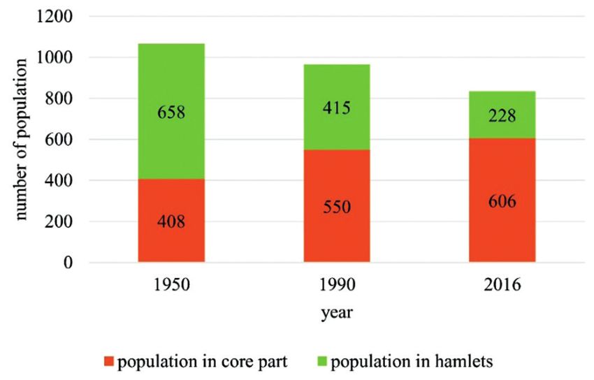
Ján HANUŠIN, Mikuláš HUBA, Vladimír IRA

legal personality, and which consists of one or a group of inhabited houses. Van
De Velde et al. (2010) in a study devoted to Flanders, Belgium defined dispersed
settlement as an area with a minimum distance of 150 meters between buildings.
Omasta (2010) defines a dispersed settlement around Myjava in western Slovakia
as a settlement in which there is at least one settlement located outside the main
settlement of a territorial unit (usually a municipality) at least 200 m away from
it. At the same time, these settlements form a larger whole, i.e. they cannot occur
alone in the territory. Špulerová et al. (2017) characterize the historical structures
of agricultural landscape (HSAL) of dispersed settlements as one of the four basic
types of HSAL in which the determining element of land use are objects of dis-
persed settlement and small block mosaics of agricultural land, such as orchards,
permanent grasslands or arable land (in the regions of southern Slovakia, rarely
also vineyard plots).
     Already the original Roman and barbaric settlements of Europe were largely
dispersed and only at the beginning of the Middle Ages this model was aban-
doned and concentrated settlements prevailed (Hoffmann 2014). Later, in the
pre-industrial period, many settlements were largely reliant on their own resources
due to high transport costs preventing the establishment of permanent trade
relations and creating conditions for a dispersion of population in the landscape
(Sieferle 2001). In the second half of the 13th and in the 14th centuries, as a result
of the division of aristocratic property, numerous one- and two-family residential
units (scattered hamlets and small settlements) were established in Slovakia (Žudel
2010). Most of the dispersed settlements still existing in the Slovak Carpathians
are considerably younger and were created in several settling waves between the
16th and 19th centuries (Hromádka 1943, Verešík 1974, Horváth 1980).
     Ethnographers were pioneers in the interest in kopanitse dispersed settlement in
Slovakia. Already at the beginning of the 20th century, several monographs devoted
to this issue were published. Medvecký (1905) was one of the first who pointed out
the transformation of seasonal settlements in the area (lazy) into permanent ones in
the monograph Detva. In the work Cerovo, Chotek (1906) notices the transformation
of temporary settlements in the village of Cerovo (in the Krupinská planina, plain),
where there was a relative surplus of usable land due to low natality.
     Because the study of dispersed settlements is of a complex nature, most studies
have been carried out in geography and related sciences. In the first half of the last
century, it was mainly the works of Martinka (1927), Janšák (1929), Deffontaines
(1931), Hromádka (1943) and Fekete (1947), that laid the basis for research into this
type of settlement in Slovakia. Later on, the issue of dispersed settlements from the
geographical aspect was dealt with by Lukniš (1950, 1980), Verešík (1974), Lauko
(1985), Huba (1986, 1989, 1990, 1997), Spišiak (1998), Petrovič (2006 a, b), Šolcová
(2008), Omasta (2010, 2011), Zrníková and Hrčková (2012), Hanušin and Lacika
(2017, 2018).

                                    Folia Geographica, Volume 62, No. 2, 106–132, (2020) • 109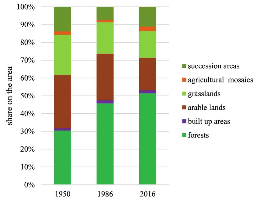
CHANGES OF DISPERSED SETTLEMENTS IN RURAL CULTURAL LANDSCAPE
                           FROM THE STRATEGIC PERSPECTIVE (WITH SPECIAL ATTENTION
                                 TO THE VILLAGE HRUŠOV IN CENTRAL SLOVAKIA)

    In addition to geographers and landscape ecologists, ethnologists (e.g. Priečko
2003, 2015, Švecová 1975, 1980, 1984, 1988), historians (e.g. Horváth 1980,
Mésároš 1966, Prelovská 1987, Varsík 1972), territorial planners (e.g. Belčáková and
Pšenáková 2013, Nahálka et al. 1966, Sitár 1967) also participated in the research
of dispersed settlements. The phenomenon of dispersed settlement in Hrušov is
relatively widely studied (Botík 1980, Brada et al. 2014, Hanušin and Lacika 2017,
2018, Švecová 1975, 1980, 1984, 1988, Zrníková and Hrčková 2012). Dispersed set-
tlement research is gradually losing the predominant character of basic research
and increasingly moves into application.
    Dispersed settlements in several form occur in many countries around the
world but the studies explicitly addressing this issue are relatively underrepresent-
ed. Studies from Japan are known from the 1950s (Matsumoto 1950, Okamoto
1955 and Takaki 1958). The theory of localization of farms in the USA Corn Belt,
which are one of the types of dispersed settlements, was studied by e.g. Birch
(1967) and Hudson (1969). The development of a specific form of dispersed settle-
ment (khutors) in the European part of Russia was studied by Rostankowski (1982).
Owen and Sarlov-Herlin (2009) studied dispersed settlements in the UK in terms of
sustainability; Lake et al. (2014) studied dispersed farmsteads in Kent, UK. The prev-
alence of dispersed settlements in agricultural landscape of Ireland is highlighted
by EPA (2008). Dispersed settlements – tanye – were studied in the Hungarian
lowlands by Kovács and Farkas (2011), dispersed and decentralized settlements in
Slovenia were analyzed by Černe (2004) and Hočevar (2012), in the eastern part of
the Balkan Peninsula by Frolec (1980), in southern Spain by Amate et al. (2016). The
position and development of dispersed settlements in the wider context of settle-
ment systems have been studied by e.g. Fletcher (2019) and Troha (2017). Decades
ago Dovring and Dovring (1965) have drawn attention to the link between farm
settlements, landscapes and the social structure of the area.
    In the 1980s, the Commission of the International Geographical Union (IGU) on
Rural Development began to pay systematic attention to this issue. Among the
several studies carried out on its platform, it is at least worth to mention the work
of Leitmeir (1983) on rural settlement in the Alps, Rikkinen (1981) on scattered
settlement in Lapland, Tiner (1983) on transport problems of small mountain set-
tlements in northern Hungary, Chiffele (1983) on Swiss mountain farming policy
and Almedal (1983) on the transformation of rural settlements in northern Norway.
Other relevant research includes the work of Symon (1959) on the past and present
of farming in Scotland, Ehlers (1974) on current trends and problems of agricultural
colonization of boreal forests, or Majoral (1977) on the consequences of depopula-
tion tendencies in scattered settlements in the Western Pyrenees.
    As we have already indicated above, territories with dispersed settlement in
Slovakia, including the territory studied by us, are referred to as marginal. Marginal
and marginalized territories in cultural landscape represent a specific environment

110 • Folia Geographica, Volume 62, No. 2, 106–132, (2020)
Ján HANUŠIN, Mikuláš HUBA, Vladimír IRA
with distorted functional and spatial relationships that result from the uneven
functioning of mutually conditioned political, economic, social, cultural and envi-
ronmental factors (Ira 2019). Marginality research focuses on many different topics
considering the scale and the type of marginal region that the specific research
is dealing with. The regions with traces of marginality, with clearly observable
marginality issues and with severe marginality problems will probably attract the
geographical research in fields of identification of marginal individuals or social
groups, identification of the type of marginality, identification of consequences,
identification of marginalizing factors, and identifying the role of geographical
factors (Pelc 2017).
Several scholars tried to study marginality through specific approaches to go
deeper into explanation. Leimgruber (1994) in his work defined marginal regions
and proposed four different approaches: geometrical, ecological, economic, and
social. He also mentioned political and cultural approaches. Ira et al. (2014) and
Ira (2019) applied time-geographical approach analysing time-space behaviour of
inhabitants living in marginal mountainous region. Poláčková (2010) has defined
a political approach and identified four main trends of political marginality and
its research in regions. She has also mentioned the perception approach focused
on marginality through human perception, values and decisions. Marginality and
marginal regions were also analysed in the context of globalization and deregu-
lation (Leimgruber 2004). In a later published work Leimgruber (2007) states that
marginality can be seen as a state of mind and it is subject to our respective value
system. The study of the individual perception of marginality may contribute to
the understanding of similarities and differences in defining marginality from two
different perspectives: objective and subjective (Mikuš et al. 2016).
DATA AND METHODS
Basic indicators for assessing changes in the landscape with dispersed settlements
were the nature of land cover and the number of hamlets which we processed and
analyzed for the years 1950, 1986 (1990 for demographic data) and 2016. The peri-
od between the years 1950 – 1986 (1990) is referred to as the first period; the peri-
od between 1986 (1990) – 2016 was the second period. Settlement pattern of the
study area consists of a core (densely built up area of the original settlement) and
the network of hamlets spread over the rest of the cadastre. The observed time ho-
rizons express the state of land cover (LC) in the pre-collectivization period (1950),
in the period of advanced collectivization (1986), and in the recent period (2016).
The basic database for the year 1950 was georeferenced sheets of the historical
orthophoto aerial images of Slovakia from the same year (Historická ortofotomapa
© GEODIS SLOVAKIA, s.r.o., et al.). Aerial images from 1986 were georeferenced to
the S-JTSK coordinate system. The database for the preparation of the LC map for
Folia Geographica, Volume 62, No. 2, 106–132, (2020) • 111CHANGES OF DISPERSED SETTLEMENTS IN RURAL CULTURAL LANDSCAPE
FROM THE STRATEGIC PERSPECTIVE (WITH SPECIAL ATTENTION
TO THE VILLAGE HRUŠOV IN CENTRAL SLOVAKIA)
the year 2016 consisted of relevant sheets of the aerial orthophotomap from 2003
updated based on the Google Earth map server (Google Earth Pro 2016). LC data
were processed and analysed in ArcGis 10.1 and Excel. Although we mapped and
interpreted a total of 15 LC types, for simplification we evaluated only 6 main types:
arable lands, permanent grasslands (referred to as grasslands), forests and non-for-
est woody vegetation (referred to as forests), built-up areas in hamlets including
adjoining gardens (referred to as hamlets) and areas with succession (referred to
as succession areas). In defining and description of the land cover types a classifi-
cation proposed by Oťaheľ et al. (2017) was adopted. The main types cover more
than 95% of the area in all periods under review. When evaluating LC conversion,
we followed the conversion tables as defined by Feranec et al. (2002); the extent of
changes was obtained from the pivot table.
Detailed data on the population of each hamlet were obtained from the 1950
census (Národný archív SR 1950), documents for the proposal of the Territorial Plan
of Hrušov (Kolektív 1990) and from the parish register (Matrika, Hrušov).
In our case study we have used both qualitative and quantitative factors to
measure marginality. When we think of changes in cultural landscape, the thoughts
about ”marginality in the mind” can be identiefied indirectly through people’s
relationship to and a behaviour in the landscape / environment. The analyses of
20 structured interviews with local leaders and opinion makers and representatives
of municipality in Hrušov (Huba and Ira 2020) revealed perceptions of respondents
about how marginal they felt or not. The sampling was carried out using recom-
mendations for the selection of interviewed persons proposed by the mayor and
two members of the municipal council. It means that observer can determine
whether local individuals or community have lost some decision power or not, and
thus this process could be identified as a marginalisation process (Déry et al. 2012).
As far as quantitative factors are concerned we have measured the marginality
using data on: geographical remoteness (peripheral to the most developed and
populous areas of the southern part of Central Slovakia); dispersed populations
partly dependent on local limited resources, partly on resources obtained through
jobs outside the municipality; actual lack, or low levels of physical and social infra-
structure; lack, or low levels of access to the towns (cities) where services, facilities
and economic opportunities are concentrated; “low productivity” of economic
activities; and in the past decades the population with political influence on the
decisions affecting their lives.
The last methodological step is a critical analysis of international and domestic
Slovak publicly available documents, programmes and support schemes at various
levels from the perspective of the issue of dispersed settlement and its possible
future support.
112 • Folia Geographica, Volume 62, No. 2, 106–132, (2020)Ján HANUŠIN, Mikuláš HUBA, Vladimír IRA
STUDY AREA AND DEVELOPMENT OF CULTURAL LANDSCAPE
WITH DISPERSED SETTLEMENTS
The main areas of the kopanitse dispersed settlement in Slovakia were defined and
first named by Hromádka (1943). In a slightly amended form, this division was taken
over by Nahálka et al. (1966), who used the names of orographic units used at the
time to designate the main areas as a unifying criterion and, on this basis, set aside
five areas and several sub-areas. Within this division, the village of Hrušov is located
in the area of dispersed settlements in the Slovenské rudohorie (Slovak Ore Moun-
tains) and the Krupinská planina (plain), specifically in the Krupina subregion (Fig. 1).
Figure 1
The study area
Most of the territory (the cadastral area) of the village Hrušov (2,331 ha) extends
on the border of the Ipeľská kotlina basin and the Krupinská planina plain, known
as the geomorphological sub-unit Modrokamenské úbočie slopes. The smaller
northern part belongs to the Dačolomská planina plain geomorphological sub-unit
(Mazúr and Lukniš 1978). The complex of volcanic-sedimentary rocks prevails in
the whole study area. Altitudes vary between 200 – 521 m a. s. l.; the plains in the
northern part reach an average of 450 – 490 m a. s. l. The location on the boundary
of the plain and basin determines the nature of all components of the natural
landscape. The average annual temperature is approximately 8.8 oC, the average
annual rainfall amounts to less than 600 mm (Lapin et al. 2002). Poorly permeable
volcanic rocks, lack of rainfall and location on the watersheds are the cause of low
groundwater reserves. The soil cover is dominated by Cambisols. Oak forests with
Quercus cerris and in higher positions Carpathian oak - hornbeam forests cover the
majority of the area (Maglocký 2002).
Folia Geographica, Volume 62, No. 2, 106–132, (2020) • 113CHANGES OF DISPERSED SETTLEMENTS IN RURAL CULTURAL LANDSCAPE
FROM THE STRATEGIC PERSPECTIVE (WITH SPECIAL ATTENTION
TO THE VILLAGE HRUŠOV IN CENTRAL SLOVAKIA)
The first written mention of Hrušov can be traced back to as early as 1272
(Kamasová and Bendík 1996). Around this period, a cultural landscape began to
take shape – the settlement of Hrušov (today’s core part) and a cultivated agri-
cultural landscape in its hinterland which gradually expanded mainly to the north
where there are relatively favourable conditions for agriculture. From the Middle
Ages until the mid-19th century, three-field system of agriculture was applied. The
dispersed settlement in its present form began to emerge at the end of the 19th
century, as one of the youngest of its kind in Slovakia (Botík 1980). The hamlets
were founded by locals, unlike most of the surrounding villages where the hamlets
were founded by the immigrants from the northern regions (Švecová 1984). Later
on, the hamlets have been transformed from seasonal to year-round housing. Grad-
ually, most of the local people owned two homes – one in the core part and the
other one in the hamlet. This double residency fully developed during the World
War I (Brada et al. 2014). The double residency lasted almost the entire 20th century
and undoubtedly affected the way of cultivation techniques and LC structure. Even
in 1991, nearly half of the 437 houses in the area were hamlets (Program rozvoja
obce Hrušov 2015).
Individual hamlets (lazy) are named after their founders and families, e.g.
Matiašov vrch, Husár’s settlement (Husár pusta), Brachovo (Brachova pusta,) and
Stachov vŕšok. In the past, Hrušov suffered for a long time from the lack of water
sources and transport connections, which made the daily life of its inhabitants dif-
ficult. Construction of the water supply system in the 1970s at least partially solved
the problem of water scarcity. Even a long time after World War II, the village had
no transport links to the surrounding area and its urban centres. The bus service
from Vinice, a few kilometres south of Hrušov to the nearest town of Šahy did not
start operating until May 1957. The electricity network for 60 families living in lazy
became a reality in 1968. The new road to the towns of Krupina and Levice took
the longest time to build. It was not completed until 1968. Larger construction
activity after the stagnation caused by World War II took place at the turn of the
1950s and 1960s.
During the onset of socialism after 1950, unlike most of Slovakia, the process of
collectivization of agriculture into cooperative farms (abbreviation for agricultural
cooperatives in Slovak is JRD) did reach Hrušov. The character of LC inherited from
the interwar period remained with little changes for the next decades. Land own-
ership rights completely changed. The peasants could not (except for small private
farms) own the land, they could only use it. Foundation of JRD in 1979 changed
the utilization of landscape and the way of life in the village albeit not totally.
Small fields merged into large blocks where non-profitable, hard-to-reach fields
in higher slope positions were afforested, management and service activities were
centralized. Hamlets, as protuberant land management points, gradually lost their
importance and many of them were later depopulated.
114 • Folia Geographica, Volume 62, No. 2, 106–132, (2020)Ján HANUŠIN, Mikuláš HUBA, Vladimír IRA
After the end of socialism in 1989, part of the land cultivated by JRD returned
to private hands, part is managed by the agricultural cooperative in Cerovo. Local
people continued to move out from hamlets to the core and the total population
of the municipality decreased. Part of the houses in hamlets remained abandoned
or their function converted to recreational. Abandonment of agricultural land con-
tinued. On the other hand, several new farmers came to Hrušov from outside.
RESULTS
Dispersed settlement and its demographical background
The basic demographic trend is the overall population decline of the municipali-
ty accompanied by population increase in the core part and a significant decline
in hamlets (Fig. 2). In 1950, almost two-thirds of the population lived in hamlets
which imply that most of the agricultural activities were carried out in the hamlets
and their surroundings. The distribution of hamlets across the cadastre, the sys-
tem of road network connecting individual hamlets and the position of core part is
significantly determined by the morphological characteristics of the area (Hanušin
and Lacika 2017).
The number of houses in hamlets varied from 1 to 12 during the monitored
periods. Moreover, there were additional farm buildings across most of hamlets.
The number of permanently inhabited houses did not change substantially over
time which refers to a decrease in the average number of inhabitants in one
house. The share of occasionally inhabited houses in the total number of houses in
hamlets increased from 30% in 1990 to 35% in 2016. Most of the houses in hamlets
have been built before 1945, and about a quarter of them were build between
1946 and 1980 . Construction considerably diminished (Kolektív 1990) later, which
is related to the decline of population. While in 1950 there were 10 uninhabited
hamlets, their number increased to 15 in 1990 and 22 in 2016. In the second period
a kind of centripetal spatial concentration of the population associated with the
abandonment of marginal, more distant hamlets can be observed. In 1950, the
most populous hamlets were concentrated in the central and northern part of the
area. In 1990, the zone of uninhabited hamlets concentrated near the south-east-
ern edge of the area. In 2016, the zone of uninhabited hamlets spread to the north.
Many of them were on a flat plain with the best agroecological conditions. The
average distance of uninhabited hamlets from the core part of Hrušov increased
from 2,240 meters in 1990 to 3,000 in 2016. On the other hand, analogous values
for inhabited hamlet dropped from some 3,000 m to 2,800 m, confirming the
trend of depopulation of marginal hamlets. Part of abandoned houses in hamlets
acquired a new, recreational function. In 2016, there were 65 occasionally inhabit-
ed houses, that is, 28% of the total number of houses.
Folia Geographica, Volume 62, No. 2, 106–132, (2020) • 115CHANGES OF DISPERSED SETTLEMENTS IN RURAL CULTURAL LANDSCAPE
FROM THE STRATEGIC PERSPECTIVE (WITH SPECIAL ATTENTION
TO THE VILLAGE HRUŠOV IN CENTRAL SLOVAKIA)
Figure 2
Population in core part and in hamlets
LC pattern and its changes
The general trend of LC changes is that of a decrease in the share of arable lands,
grasslands and agricultural mosaics and increase in the share of forests (Fig. 3) indi-
cating that the intensity of agricultural land use was declining. Overall, the increase
Figure 3
Land cover in 1950, 1986 and 2016
116 • Folia Geographica, Volume 62, No. 2, 106–132, (2020)Ján HANUŠIN, Mikuláš HUBA, Vladimír IRA
in forests was approximately the same as the total decrease in arable land and per-
manent grassland. The area of hamlets increased only very slightly. The common
features of the distribution of the main LC categories in all observed years were the
predominance of forests on the western, eastern and partially southern margins
and in the sloping positions in the centre of the area.
As for LC conversion, no-change areas dominated (Fig. 4 a, b). Regarding
the higher proportion of no-change areas, the second period was more stable
compared to the first period, aforestation was the prevailing change in both
periods. Other significant changes were the antagonistic changes in extensifica-
tion and intensification of agriculture. In both periods, aforestation concentrated
mainly in more sloping locations in the central and southern parts of the territory.
Originally successive areas and areas of grasslands have been transformed into
forests. Intensification of agriculture dominated in the northern plateau part of
the territory, where the conditions for agricultural production are more suitable.
During the extensification / intensification of agriculture, in most cases the grass-
lands changed into arable land and vice versa.
Dispersed settlement of Hrušov in relation to marginality
As already mentioned in terms of location within Slovakia, self-governing region
and district, as well as in terms of limited transport accessibility, Hrušov is undoubt-
edly part of the marginal territory. In terms of natural soil fertility, climate and oth-
er natural conditions for agriculture, these are factors that enhance the territorial
marginality.
Although marginality is generally considered a negative phenomenon that
limits conventionally understood development and prosperity, in case of Hrušov
we observe the efforts of the local community to “escape” marginality by pre-
serving local traditions, farming, maintaining regional fruit varieties (gene pool),
a healthy environment, a harmonious cultural landscape and the related quality of
life. Hrušov eliminates negative aspects of marginality like few similar municipali-
ties in Slovakia, partly due to quite suitable conditions for some types of agricul-
tural production, but especially due to the systematic efforts of the municipality’s
management and active members of the local community. Thanks to this, Hrušov is
not only a leader within the micro-region, but some of the local activities acquired
a supraregional character. This applies in particular to the Hontianska paráda event,
but also to the scope and quality of micro-scale (micro-regional) research and
published outputs about the village and its population (see e.g. Bendík, ed., 2019),
museum exhibitions, locally oriented educational infrastructure, local folklore en-
sembles, associations and so on.
Recently, another phenomenon that helps the municipality to escape mar-
ginality is that of “newcomers” which may significantly slow down the process
Folia Geographica, Volume 62, No. 2, 106–132, (2020) • 117CHANGES OF DISPERSED SETTLEMENTS IN RURAL CULTURAL LANDSCAPE
FROM THE STRATEGIC PERSPECTIVE (WITH SPECIAL ATTENTION
TO THE VILLAGE HRUŠOV IN CENTRAL SLOVAKIA)
a)
b)
Figure 4
LC conversion in the first period (a) and second period (b)
118 • Folia Geographica, Volume 62, No. 2, 106–132, (2020)Ján HANUŠIN, Mikuláš HUBA, Vladimír IRA
of abandoning hamlets and releasing the surrounding agricultural land. These
are middle-aged and younger people who moved to Hrušov from other parts of
Slovakia (and even Czechia) with the aim of permanent stay and farming. These
are not weekend and holiday vacationers or cottagers, whom we know from
other regions of dispersed settlements in Slovakia. In addition to the restoration
and maintenance of the residential and farm buildings, these new permanent
residents of Hrušov are engaged in cultivation of traditional crops and raising live-
stock, introduction of permaculture, revitalisation of traditional crafts, or provision
of accommodation and other services. They also contribute to the study of local
conditions (environment) and participate in their professional interpretation and
promotion (see e.g. Brada et al. 2014, Bendík (ed.) 2019).
Perspectives of dispersed settlement in Hrušov in the light of the
institutional framework
Despite numerous factors limiting the continued existence of dispersed settle-
ments, there are several conventions, strategies, programmes, schemes, instru-
ments, and measures that directly or indirectly support its continued existence and
sustainable development, at the international, national, regional and local levels.
This is true not only in the national scale, but also in application to a specific mu-
nicipality (village Hrušov).
The individual international documents that the Slovak Republic has under-
taken to comply with form a framework, an argumentative basis and, to a limited
extent, supportive (financial and other) mechanisms in favour of maintaining the
dispersed settlement and the surrounding rural cultural landscape. They concern
strategic, institutional, environmental, economic, social and, last but not least,
cultural issues. Of the several relevant ones, we mention at least some of them.
At the UN ECE level, it is The Framework Convention on the Protection and Sus-
tainable Development of the Carpathians (Carpathian Convention, 2003), at the
European level Landscape Convention of the European Council (2000) and at the
level of the European Union the Common Agriculture Policy 2014-2020 (European
Commision (2013). Equally important and logically much more concrete and
targeted are the relevant documents of the domestic provenance: at the level of
the Slovak Republic - Programové vyhlásenie Vlády Slovenskej republiky (Program
Declaration of the Slovak Government for Years 2020 - 2024), at the regional level
it is the Územný plán VÚC BBK (Territorial Plan of the Banská Bystrica Region (last
updated in 2014), Program hospodárskeho a sociálneho rozvoja BBSK 2015-2023
(Programme of the Economic and Social Development of the Banská Bystrica
Region 2015 - 2023), and Program rozvoja obce Hrušov na roky 2015-2024 (Plan
of the Local Development of Hrušov for 2015 - 2024) at the local level. All the men-
tioned documents contain parts which are important from the point of view of
Folia Geographica, Volume 62, No. 2, 106–132, (2020) • 119CHANGES OF DISPERSED SETTLEMENTS IN RURAL CULTURAL LANDSCAPE
FROM THE STRATEGIC PERSPECTIVE (WITH SPECIAL ATTENTION
TO THE VILLAGE HRUŠOV IN CENTRAL SLOVAKIA)
further existence and sustainable development of the municipality of Hrušov and
dispersed settlements on its territory.
The Framework Convention on the Protection and Sustainable Development of the
Carpathians or the Carpathian Convention (2003) pursues a comprehensive policy
and cooperation in the protection and sustainable development of the Carpathi-
ans. Several parts of this Convention are relevant for Hrušov village too. E.g. Article
5/1 Spatial planning declares: “The Parties shall pursue policies of spatial planning
aimed at the protection and sustainable development..., which shall take into
account the specific ecological and socio-economic conditions in the Carpathians
and their mountain ecosystems, and provide benefits to the local people. Article
7/1 Sustainable agriculture and forestry demands maintaining the management
of land traditionally cultivated in a sustainable manner... taking into account the
need of the protection of mountain ecosystems and landscapes, the importance
of biological diversity, and the specific conditions of mountains as less favoured
areas. And Article 11 - Cultural heritage and traditional knowledge recommends
policies aiming at preservation and promotion of the cultural heritage and the tra-
ditional knowledge of the local people, crafting and marketing of local goods, arts,
and handicrafts. To preserve the traditional architecture, land-use patterns, local
breeds of domestic animals and cultivated plant varieties, and sustainable use of
wild plants.
Another important international document, party of which is the Slovak
Republic, is the European Landscape Convention of the Council of Europe in 2000.
Several parts of this Convention are also important for Hrušov. Article 5 demands
inter alia to recognise landscapes by the law as an essential component of people’s
surroundings, expression of the diversity of their shared cultural and natural
heritage, and the foundations of their identity, to establish and implement land-
scape policies aimed at landscape protection, management and planning through
the adoption of the specific measures..., to establish procedures for the participa-
tion of the general public, local and regional authorities, and other parties with
an interest in the definition and implementation of the landscape policies and to
integrate landscape into its regional and town planning policies and in its cultural,
environmental, agricultural, social and economic policies, as well as in any other
policies with possible direct or indirect impact on landscape.
The situation could also be improved by the new EU Common Agricultural
Policy (for 2021 – 2027), which calls for further “greening” and diversification of
agriculture and the rural landscape in the EU member states (Matthews 2018)
as well as by the new Slovak government, which in its Programme Declaration
for 2020 - 2024 (Programové vyhlásnie vlády SR, 2020) explicitly states that it will
improve the conditions of livestock breeding, and will legislatively support family
forms of business, small, young and beginning farmers, through a system of mi-
croloans. It will support the active economic use of the foothills and mountain
120 • Folia Geographica, Volume 62, No. 2, 106–132, (2020)Ján HANUŠIN, Mikuláš HUBA, Vladimír IRA
landscape with a special focus on the dispersed settlement areas, restoration
and preservation of traditional farm management systems in the landscape with
dispersed settlements (lazy, kopanice, štále), development of agrotourism and
preservation of the original Slovak gene pool in agricultural production. As part
of increasing self-sufficiency, it will pay special attention to crops typical for our
soils and climatic conditions. It will provide support for sectors that are potential
sources of employment and value addition such as livestock production, special
crop production, fruit growing, vegetable growing, viticulture, beekeeping and
other, in order to maximize processing of raw materials from domestic production.
The issues discussed in this paper also relate to regulations of the Územný plán
VÚC BBK (Territorial Plan of the Banská Bystrica Region update from 2014), which
requires, among other things, ensuring the permanent landscape protection in ac-
cordance with the European Landscape Convention aimed at the preservation and
maintenance of significant or characteristic features of landscape resulting from its
historical heritage and natural layout or human activity.
Similarly, Program hospodárskeho a sociálneho rozvoja BBSK (Programme of
the Economic and Social Development of the Banská Bystrica Region 2015 – 2023,
2015) states that more attention needs to be paid to regional and rural policy in
order to increase the attractiveness of rural life and stop the growth of negative
factors and especialy to improve the quality of life. The aim of the programme’s
measures should be to create a multifunctional rural environment that affects all
areas of rural life - not only economic, but also social, cultural, environmental and
institutional.
Since 2000 until now Hrušov has been a member of three micro-regional as-
sociations. Since 2015, it is the Hontianske Poiplie Civic Association, consisting of
30 municipalities. Hrušov has the ambition to play a leading role within this volun-
tary association of the municipalities of the micro-region.
The municipality of Hrušov does not currently have an official territorial plan or
programme of economic and social development. They are partially replaced by
the Community Development Programme (CDP) for 2015 - 2024. According to this
programme, the village has preserved its distinctive character to this day with tra-
ditional folk elements of housing, culture and clothing. In addition to growing the
common crops, the inhabitants of Hrušov are engaged in cattle, sheep breeding
and viticulture. According to the CDP, the municipality of Hrušov has a real poten-
tial primarily for the development of rural tourism, including agrotourism (which
is provided by the entrepreneurs in agricultural production and which serves as an
additional financial source to maintain or expand the main business programme).
These activities are directly connected with natural landscape and rural environ-
ment; they contribute to the overall development of the village especially by
enabling the use of the rural environment (dispersed settlements, viticulture and
wine cellars), create new jobs and help the renewal and development of the village.
Folia Geographica, Volume 62, No. 2, 106–132, (2020) • 121CHANGES OF DISPERSED SETTLEMENTS IN RURAL CULTURAL LANDSCAPE
FROM THE STRATEGIC PERSPECTIVE (WITH SPECIAL ATTENTION
TO THE VILLAGE HRUŠOV IN CENTRAL SLOVAKIA)
As far as tourism is concerned, the starting point for the village of Hrušov is, accord-
ing to CDP, to preserve the tradition, customs and way of life of Hrušov. The inter-
national event of traditional culture, the Hontianska paráda festival, offers people
an insight into the life of this unusual village. The village provides specific tourism
products to visitors throughout the year. These include private accommodation in
the countryside and in the village with the accompanying adventure activities. The
product of rural tourism is based on domestic resources and is implemented by the
inhabitants of the village. The “Regional HONT brand” product also helps to make
the countryside visible.
According to the SWOT analysis, based on an active participation of local
citizens, the main development opportunities of the municipality are as follows:
rural tourism, cultural tourism, natural (bio)agriculture, development of handicrafts
within municipality, information office - information service, the municipality as
a positive example in various areas and a leader within the micro-region, the possi-
bility of rebuilding farmsteads for tourism, restoration of original eco-agrosystems
for the specific eco-production, regional brand HONT and Ecomuseum and other
regional brands. These findings correspond to the results of field research conduct-
ed through structured interviews (Huba and Ira 2020).
The main strategic goal of CDP in Hrušov is to ensure a balanced and sustain-
able development of this unique village aimed at preservation of folk traditions
and improvement of the economic and social conditions of life in the municipal-
ity. The basis for the development of the municipality will be the evaluation of
its internal potential with the use of external additional resources. The relevant
proposed projects for 2015 – 2024 are: reconstruction of folk buildings in the
village and construction of museums with different focuses, completion of the list
of monuments (buildings and areas protected by the municipality) and support
to the declared protected buildings, landscaping - preserving the traditional
cultural landscape, construction of buildings for storage and presentation of his-
torical farm equipment, collection and purchase of museum objects, construction
of facilities for processing fruit, vegetable, support of a common point of sale for
local products, support of young farmers and family farms, implementation of
pilot and cyclical events (ethnography, traditional agriculture, technology, crafts,
sports, etc. ), mapping of regional and traditional varieties, their use and presenta-
tion, establishment of the gene pool orchards, care for the existing gene pool,
material and technical equipment for groups to maintain the folklore character of
the village, implementation of anti-erosion measures - restoration of plantations,
especially along roads, implementation of anti-flood measures - water retention in
the landscape (transverse and longitudinal modifications of ditches, seepage pits,
small water reservoirs, road modifications, restoration of wells - backup sources,
irrigation, etc.).
122 • Folia Geographica, Volume 62, No. 2, 106–132, (2020)Ján HANUŠIN, Mikuláš HUBA, Vladimír IRA
DISCUSSION
During 1991 – 2011, the population decrease (62%) in hamlets of Hrušov was high-
er compared to average 52% decrease in five surrounding villages with dispersed
settlement in the Krupinská planina plain (Štatistický lexikón obcí SR 1992, 2011,
own calculations). The probable cause is the double residency model in Hrušov.
Unlike most of the hamlet villages, where a hamlet serves as an exclusive resi-
dential place, Hrušov hamlets were not exclusive residency for many locals. Thus,
a double residency model allowed them migration between the core part and the
hamlet, if it was convenient to them. Similar depopulation model – migration from
hamlets to the core part – was reported in Montefrio in southern Spain. The num-
ber of the population living in a dispersed settlement reached its peak in the 1940s
– 1950s when it significantly exceeded the number of the population in the core
part, and since then it has been continuously declining (Amate et al. 2016).
The second half of the 20th century and the beginning of the 21st century in
East-Central Europe were characterized by dynamic socio-economic changes
which also left traces in the landscape (Demek et al. 2012, Haase et al. 2007, Kani-
anska et al. 2014). In addition to these regional driving forces of landscape changes,
the local specificities of Hrušov were of crucial importance – a dispersed settlement
by its genesis different from most of the dispersed settlement types in the near and
distant surroundings, position on the ethnical Slovak-Hungarian divide, marginal
position towards Czechoslovak, and later Slovak central regions, and last but not
least, the confessional exclusivity of the local population towards the surrounding
villages. These factors underlined conservatism of the local people which, besides
some negatives, also had significant positive consequences reflected in their
self-confidence, independence, activism and a high level of self-sufficiency in pro-
cessing of food and articles for everyday life.
In 1950, hamlets were the focal points of agricultural production, most of the
farm animals were housed here (Brada et al. 2014). The appearance and function-
ing of the agricultural landscape between 1950 and 1979 changed only very little.
Here too, the mechanization and chemicalization of agriculture has been applied,
increasing its efficiency but not to the extent as it was in regions with collectivized
farms (Brada et al. 2014). However, this has not fundamentally affected the agricul-
tural landscape pattern. It can be assumed that most of the significant changes in
LC during the 1st period (1950 – 1986) concentrated into a relatively short 7-year
final period after 1979 when the collectivization process began. The process of
migration from hamlets to the core began already before 1980, while the total
population of the municipality did not decrease (Matrika Hrušov). New job oppor-
tunities and a more comfortable life caused the emigration of many young people
to the cities, and the relationship between people and the land has been torn
down. In 1989, shortly after 1986 which is a turning point between the monitored
Folia Geographica, Volume 62, No. 2, 106–132, (2020) • 123CHANGES OF DISPERSED SETTLEMENTS IN RURAL CULTURAL LANDSCAPE
FROM THE STRATEGIC PERSPECTIVE (WITH SPECIAL ATTENTION
TO THE VILLAGE HRUŠOV IN CENTRAL SLOVAKIA)
periods, another turning point occurred in the political and economic develop-
ment of former Czechoslovakia – the end of socialism, advent of democracy and
market economy with all positives and shortcomings, and establishment of the in-
dependent Slovak Republic in 1992. Socialist collectivization model ended; part of
the land was given back to the original owners. A new farming cooperative started
on part of the agricultural land in 2001. New farmers were facing the problems of
fragmented and unclear land ownership which were not solved during the socialist
era. On the other hand, cultivation efficiency has increased.
For Hrušov, as well as for other municipalities in Slovakia with dispersed settle-
ments, it is very important whether the declarations can be adopted and imple-
mented, and especially specific tools and measures to preserve values and alleviate
the existing restrictions and disadvantages associated with life and by farming in
the landscape with dispersed settlement. Several measures promised by the new
Slovak government for the preservation of the rural landscape, cultivation of tra-
ditional crops, breeding of domestic animals and sale of food from the yard seem
to be challenging. For the first time in history, the Slovak government has explicitly
(even repeatedly) committed itself to support the renewal and preservation of the
traditional dispersed settlement management systems. Similar measures have
been introduced in the past by the governments of several European countries
where similar settlements occur (see, e.g. Leitmeir, 1983). The bill, which regulated
the conditions of such support for Slovakia, was submitted to a group of deputies
as early as 2015 (and repeatedly since then), but it never received enough support.
The explanatory memorandum to the bill states, among other things, that dis-
persed settlements is one of the distinctive manifestations of socio-economic
activity, conditioned by specific natural and historical environments. In many EU
countries, inhabitants of such remote areas are financially favoured, e.g. there is
a possibility for them to obtain the governmental subsidies (e.g. Finland, Austria
and Romania). In Greece, families with children living in mountainous and dis-
advantaged areas are supported by annual financial support. In Sweden, there
are legal regulations for sparsely populated areas, the aim of which is to create
equal economic conditions for all municipalities and regions in the country (NR
SR, Parlamentná tlač 1532, 2015). For more on the topic of support for farmers in
disadvantaged areas in various European countries, see e.g. Parliamentary Institute
of the National Council of the Slovak Republic (2018).
CONCLUSION
Unlike most dispersed settlements regions in Europe and Slovakia, the character
of the dispersed settlement in Hrušov has been generated historically during a rel-
atively short period of time which was one of the reasons why a specific type of
a scattered settlement arose there. The local specificities lie at the three areas: set-
124 • Folia Geographica, Volume 62, No. 2, 106–132, (2020)Ján HANUŠIN, Mikuláš HUBA, Vladimír IRA
tlement-demographic (double-residency model), political-economic (delayed and
relatively short-term collectivization of agricultural production) and finally geoeco-
logical (high proportion of plains in the highest altitudes of the area which have
the most suitable conditions for agriculture cultivation). Concurrence of these spe-
cificities clarifies that the obtained results differ in some aspects from the results
obtained in other areas with dispersed settlement in Slovakia.
The transformation of local conditions in Hrušov and in the cultural landscape
with dispersed settlement through the integration into systems of new political,
socio-economic and cultural contexts is underlying the question of how to adapt
to these new conditions. Our research showed that some people (mostly local
leaders) are able to cope with the new conditions, that is, to learn the new ideas,
skills, technologies or procedures perceived necessary to function within the new
system in order not to remain marginalised.
The study contributes to the dissemination of knowledge of the dispersed
settlement landscape which is a traditional and important part of the settlement
system in many countries and is one of the types of a historical cultural landscape.
The results of the study can serve as inspiration for local plans for social and
economic development as well as for planning the sustainable development of
a region with a specific dispersed settlement.
Acknowledgement
This paper was prepared within the project of the Scientific Grant Agency of the Min-
istry of Education, science, research and sport of the Slovak Republic and the Slovak
Academy of Sciences VEGA No. 2/0013/18 Evaluation of the transformation of natural
and socio-cultural diversity of the cultural landscape in Slovakia (on example of select-
ed areas).
REFERENCES
ALMEDAL, S. (1983). Changes in Rural Settlement in Northern Norway in the 1970´s.
Norther and Mountain Villages under Pressure of Change. Oulu: IGU.
AMATE, J. I., VILLA, I., JIMENÉZ, F., DE MOLINA, M. G. (2016). The rise and fall of the
cortijo system: scattered rural settlements and the colonization of land in Spa-
in‘s Mediterranean mountains since 1581. Journal of Historical Geography, 54,
63-75.
BELČÁKOVÁ, I., PŠENÁKOVÁ, Z. (2013). Špecifiká a krajinné podmienky rozptýlené-
ho osídlenia na Slovensku - príklad prírodného, historického a kultúrneho de-
dičstva. In Merunková, I. ed., Krajina v proměnách času. 18. kolokvium kateder
záhradní a krajinářské tvorby s mezinárodní účastí 26. 9. 2013 v Praze. Praha:
Česká zemědelská univerzita, pp.32-37.
Folia Geographica, Volume 62, No. 2, 106–132, (2020) • 125You can also read