A strong atmospheric river (AR) is forecast to make landfall around 4 PM PST tomorrow, 26 January 2021 The AR is then forecast to propagate ...
←
→
Page content transcription
If your browser does not render page correctly, please read the page content below
CW3E Atmospheric River Outlook                                                   For California DWR’s AR Program

Strong atmospheric river may bring several hydrologic impacts to large portion of California early this week
• A strong atmospheric river (AR) is forecast to make landfall around 4 PM PST tomorrow, 26 January 2021
• The AR is then forecast to propagate down the coast, bringing AR 1 to potentially 3 conditions to a large stretch of
  the Central CA Coast.
• Several locations across the Central Coast and the high elevations of the Sierra could receive more than 10 inches
  of precipitation.
• Low freezing levels (
AR Outlook: 25 Jan 2021                                                                                 For California DWR’s AR Program

GFS IVT/IWV Analyses and Forecasts
  (A) Valid: 0000 UTC 27 Jan (F-36)                     (B) Valid: 15 UTC 27 Jan (F-51)                    (C) Valid: 0900 UTC 28 Jan (F-69)

• The AR is currently forecast by the GFS to make landfall at ~00 UTC 27 January 2021 (4 PM PST 26 January) over Northern CA (Figure A)
• The AR is forecast to propagate down the coast, bringing IVT magnitudes >600 kg m−1 s−1 to the central CA Coast at 15 UTC 27 Jan (Figure B)
• An upper-level shortwave trough is then forecast to interact with the AR, causing the main corridor to rotate counterclockwise at a location near
  Point Conception, resulting in extended AR condition durations (Figure C)
• The interaction with the upper-level shortwave may also result in a mesoscale frontal wave, which could shift the AR core northward before
  propagating back southward.

AR Outlook: 25 Jan 2021                                                                     For California DWR’s AR Program

                          Probability of AR Conditions Along Coast

                                                          Low
                                                          ensemble
                                                          probabilities
                                                          associated
                                                          with frontal
                                                          wave

                                                                                *GEFS = NCEP Global Ensemble Forecast System (United States)
•    The GEFS is currently exhibiting high ensemble agreement (>95% of ensembles) in the probability AR conditions (IVT >250 kg m –
     1 s–1) during the initial landfall of the AR from 34°N to 43°N along the Coast.

•    The largest ensemble uncertainty is currently associated with the frontal wave from ~00 UTC 28 to 00 UTC 29 January
•    The GEFS is currently showing low ensemble probabilities associated with how far north the wave will propagate the core of the
     AR and how quickly that AR will shift back southward, resulting in uncertainties in overall AR duration from 34°N to 37°N (Point
     Conception to the Monterey Bay)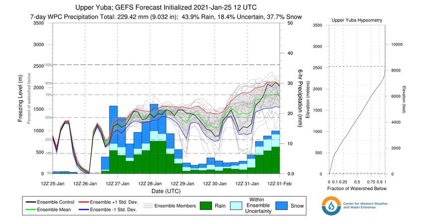
AR Outlook: 25 Jan 2021                                              For California DWR’s AR Program

           GEFS IVT/AR Scale Forecasts          • The GEFS control is currently forecasting AR 2 conditions
                                                  over the south-central Coast of California, where the frontal
                                                  wave is forecast to extend AR duration
                                                • The GEFS is also highlighting large uncertainty associated
                                                  with the overall strength and timing associated with the
                                                  frontal wave, resulting in uncertainty in overall duration and,
                                                  therefore, AR Scale.
                                                • Currently, 25 ensemble members are forecasting AR 2
                                                  conditions, while 6 members are forecasting AR 3 conditions
                                                  due to either longer duration or higher max IVT.

                              Large Ensemble
                              Spread
                              Associated with
                              Frontal Wave
AR Outlook: 25 Jan 2021                                                                 For California DWR’s AR Program

7-day Watershed Freezing Level Forecasts: Upper Yuba Watershed

                                                             Period of
                                                              heaviest
                                                            precipitation

• The WPC is currently forecasting ~9 inches of mean areal precipitation over the Upper Yuba watershed over the next 7 days
• During the period 00Z 27 Jan – 12Z 29 Jan, ~6 inches of precipitation is forecasted to occur with ~42% (~45%) of the watershed
  forecasted to experience rain (snow)
• Ensemble uncertainty of the forecasted freezing level during the heaviest period of precipitation is ~+/- 150 meters
AR Outlook: 25 Jan 2021                                                                          For California DWR’s AR Program

NWS WPC Quantitative Precipitation Forecasts                                  Source: NOAA/NWS Weather Prediction Center, https://www.wpc.ncep.noaa.gov/

Day 2: Valid 00Z 27–28 Jan       Day 3: Valid 00Z 28–29 Jan        Days 1–3: Valid 00Z 26–29 Jan           Days 1–7: Valid 00Z 26 Jan–2 Feb

• The Weather Prediction Center (WPC) is forecasting at up to 10 inches precipitation over the Sierra Nevada and coastal CA over the
  next three days
• The heaviest precipitation associated with the AR is forecasted to occur over the California Coast Ranges and the Sierra Nevada on
  days 2-3
• The WPC is forecasting more than 15 inches of total precipitation is in some areas during the next 7 days

AR Outlook: 25 Jan 2021                                                                     For California DWR’s AR Program

                                                                             Current Winter              72-hr Probability of >=24
                                                                             Weather WAAs                   inches of Snowfall

    Source: NWS Eureka, https://www.weather.gov/eka/
• Significant snowfall accumulations are expected over the higher terrain of northern California
• Forecast confidence in exact snowfall amounts is still low but there are high probabilities of >24 inches of snowfall over much of
  the Sierra Nevada
• The National Weather Service has issues winter weather advisories, watches, and warnings for much of northern CA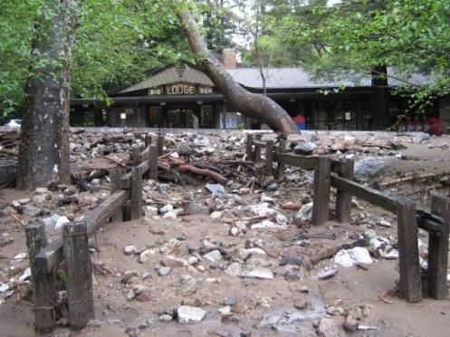
AR Outlook: 25 January 2021 For California DWR’s AR
Program
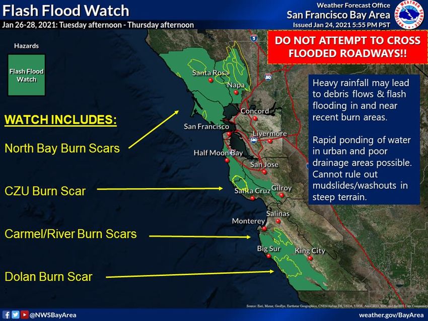
• While storm-total precipitation is a concern, impacts related to high-intensity rainfall are also possible associated with this AR
• Flash flooding and/or debris flows on recent burn scars are associated with short duration (e.g.
AR Outlook: 25 Jan 2021                                                                                              For California DWR’s AR
                                                                                                                             Program

•   Mesoscale models generally agree on the
    formation of a narrow band of moderate-
    to-high intensity rainfall along the storm’s
    cold front, though differ in timing, location,
    orientation, and intensity of rain band.
•   Front forecast to make landfall in N. CA
    Tuesday evening and propagating
    southeastward along the coast, impacting
                                                                              West-WRF GFS                                          NAM 3km
    central CA coastal mountains Tuesday
    night through Wednesday.
•   Models suggest the front will drift
    northward again Wednesday night (driven
    by the frontal wave), creating additional
    chances for high-intensity rainfall in
    Central CA.
•   Areas in the Southern CA Bight could
    potentially see high-intensity rainfall as
    the cold front passes through that region
    Thursday into Friday morning though                                  West-WRF ECMWF                                                  HRRR
    models are more uncertain on timing over
    this region.                                     Simulated radar reflectivity forecasts for 4am Wednesday. Orange-to-red colors indicate
                                                     moderate-to-high-intensity rainfall. Details are likely to evolve as the event nears.
AR Outlook: 25 Jan 2021                                                                                       For California DWR’s AR
                                                                                                                      Program
                                                   •   There is high uncertainty as to the timing, location, and intensity of rainfall
                                                       with respect to burn scars, though this event presents high potential for
                                                       exceeding debris flow thresholds.
                                                   •   Stay tuned to your local National Weather Service office and local
                                                       authorities for guidance as the situation evolves.

                                                                 Impacts of a post-fire debris flow in Big Sur, April 7th
WPC suggests marginal risk for rainfall exceeding
                                                                 2009. Impactful post-fire debris flows are less common
flash flood guidance on Tuesday for the Central CA               in central/northern CA than southern CA though still
Coast (left), increasing to slight risk on Wednesday             pose a threat to communities within/downstream of
(right) for parts of Santa Cruz, Monterey, and San Luis
                                                                 recent burn areas.
Obispo counties (Santa Cruz and Santa Lucia Mtns).
AR Outlook: 25 January 2021 For California DWR’s AR
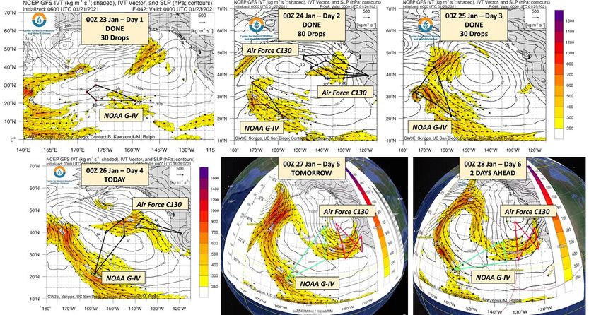
Program
• As part of Atmospheric River
Reconnaissance, in collaboration with Atmospheric River Reconnaissance 2021 Sequence-1 (23–28 January)
the US Air Force 53rd Weather
Reconnaissance Squadron and the
National Oceanic and Atmospheric
Administration (NOAA) Aircraft
Operations Center, there have been
three successive days of aircraft
operations that have sampled this
system as it has evolved
• Three additional flights are planned over the
next several days, resulting in a total of six
consecutive days of Intensive Operations
• These data will be assimilated into the global
atmospheric models in an effort to improve
what has been a very uncertain forecast.
• For more information on Atmospheric River
Reconnaissance, visit
https://cw3e.ucsd.edu/arrecon_overview/You can also read