Airspace Review of Hamilton Island - July 2009 - Trim Ref: ED09/60075 File Ref: EF09/3472
←
→
Page content transcription
If your browser does not render page correctly, please read the page content below

Trim Ref: ED09/60075
 File Ref: EF09/3472

Airspace Review of
  Hamilton Island
                July 2009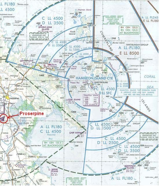
Office of Airspace Regulation                                Page 2 of 39

     DOCUMENT SPONSOR: Office of Airspace Regulation (OAR)

     Airspace Review – Hamilton Island (YBHM) – July 2009            Final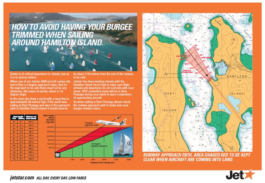
Office of Airspace Regulation                                                                                  Page 3 of 39

     Contents

1.    INTRODUCTION .................................................................................................. 4
      1.1 Overview of Australian Airspace ............................................................. 4
      1.2 Purpose................................................................................................... 4
      1.3 Scope ...................................................................................................... 4
      1.4 Objective ................................................................................................. 5
2.    AIRSPACE ......................................................................................................... 6
3.    AERODROME AND INFRASTRUCTURE ................................................................... 7
      3.1 Background ............................................................................................. 7
      3.2 Aerodrome .............................................................................................. 7
4.    STAKEHOLDER CONSULTATION ......................................................................... 12
      4.1 Internal .................................................................................................. 12
      4.2 Aerodrome Operator ............................................................................. 12
      4.3 Passenger Transport Operators............................................................ 12
      4.4 Military................................................................................................... 13
      4.5 Airservices Australia.............................................................................. 13
5.    SUMMARY OF INCIDENTS AND ACCIDENTS .......................................................... 14
6.    MODELLING METHODOLOGY AND RISK ASSESSMENT .......................................... 15
      6.1 Methodology Outline ............................................................................. 15
      6.2 Airspace Risk Assessment.................................................................... 15
7.    FINDINGS ........................................................................................................ 21
8.    RECOMMENDATIONS ........................................................................................ 21
      Annex A – Acronyms..................................................................................... 23
      Annex B – Australian Airspace Structure ...................................................... 25
      Annex C – Stakeholder input provided by: .................................................... 26
      Annex D – Aerodrome Operator Data ........................................................... 27
      Annex E – Airservices Australia Data............................................................ 28
      Annex F – BITRE Data.................................................................................. 31
      Annex G – ATSB Data .................................................................................. 33
      Annex H – Jetstar information flyers ............................................................. 36

 Airspace Review – Hamilton Island (YBHM) – July 2009                                                                    Final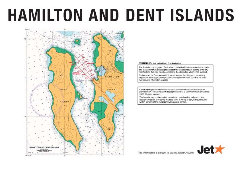
Office of Airspace Regulation                                                Page 4 of 39

1. Introduction
1.1 Overview of Australian Airspace
The Office of Airspace Regulation (OAR)1 within the Civil Aviation Safety Authority
(CASA) has sole carriage of the regulation of Australian-administered airspace, in
accordance with section 11 of the Airspace Act 2007 (Act). Section 12 of the Act
requires CASA to foster both the efficient use of Australian-administered airspace
and equitable access to that airspace for all users. CASA must also take into
account the capacity of Australian-administered airspace to accommodate changes
to its use.
In line with the International Civil Aviation Organization (ICAO) Annex 11 and as
described in the Australian Airspace Policy Statement (AAPS), Australian airspace is
classified as Class A, C, D, E and G depending on the level of service required to
manage traffic safely and effectively. Class B and F are not currently used in
Australia. The classification determines the category of flights permitted and the
level of air traffic services (ATS) provided. Annex B provides details of the classes
of airspace used in Australia. Within this classification system aerodromes are
either controlled (i.e. Class C or Class D) or non-controlled.
Non-controlled aerodromes in Australia are subject to either Common Traffic Area
Frequency (CTAF) or designated CTAF (radio required) (CTAF(R)) procedures; the
latter requiring all aircraft operating at the aerodrome to be equipped with a
serviceable Very High Frequency (VHF) radio.

1.2 Purpose
The purpose of this Airspace Review was to conduct a risk assessment of the
airspace within the vicinity of Hamilton Island, Queensland. The review forms part of
the OAR Work Program as required by the Act.

1.3 Scope
The scope of the review includes identification and consultation with stakeholders to
gather necessary data and information related to airspace issues around the
Hamilton Island aerodrome. As a minimum this includes consultation with regular
passenger transport operators, charter aircraft of non-freight carrying operations,
flying training schools, military operators, emergency services operators and the
aerodrome operator.
The scope of this review is not intended to examine aerodrome facilities and
infrastructure issues unless any weakness or failings in these areas have a
significant impact on the safety of airspace operations the vicinity of Hamilton Island.

1
 A full list of acronyms used within this report can be found at Annex A
Airspace Review – Hamilton Island (YBHM) – July 2009                                 Final
Office of Airspace Regulation                                                   Page 5 of 39

1.4 Objective
The objective of this Review is to examine the airspace around Hamilton Island
aerodrome to determine the appropriateness of the current airspace classification
and the level of aviation services provided. This was accomplished by:
     a. Analyses of current traffic levels and mix of aircraft operations within the
        existing airspace in relation to the level of services provided;
     b. Identifying any threats to the operations, focussing as a priority on the safety
        and protection of Passenger Transport Services (PTS);
     c. Identifying appropriate and acceptable risk mitigators to the known threats;
     d. Carrying out a qualitative and quantitative risk assessment of the current
        airspace environment and the expected impact of any changes;
     e. Investigating through stakeholder consultation, the appropriateness of the
        current airspace classification, access issues, expected changes to the
        current traffic levels and mix of aircraft operations within the existing airspace.
     f. Reviewing extant Aeronautical Information Publications (AIP) entries for
        applicability;
     g. Ensuring that the issues are passed onto the relative stakeholder group for
        their consideration; and
     h. Providing assurance to the Group General Manager (GGM) OAR of the levels
        of airspace risk associated with Hamilton Island. The review will provide
        guidance to OAR management on the requirements for an Aeronautical
        Study.

Airspace Review – Hamilton Island (YBHM) – July 2009                                    Final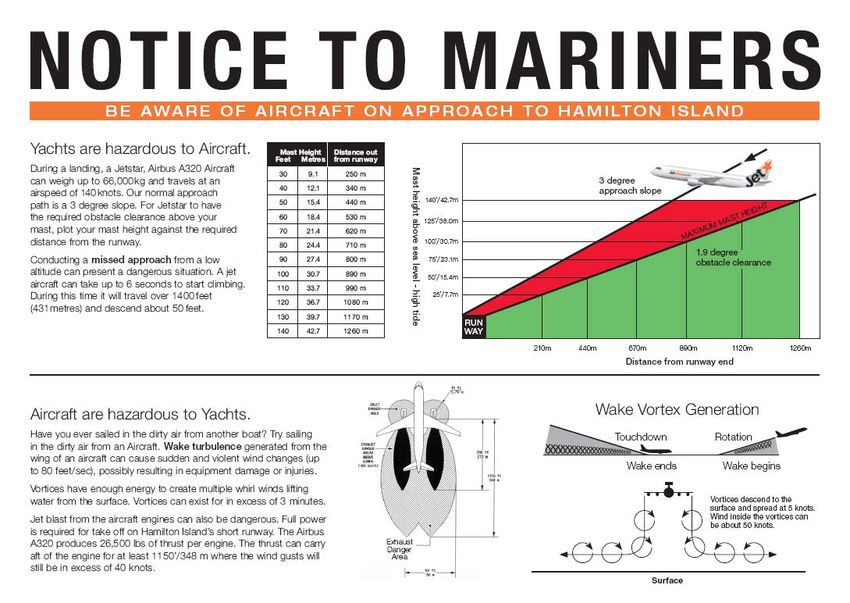
Office of Airspace Regulation                                                        Page 6 of 39

2. Airspace
During hours of tower operation, the airspace within 22 nautical miles (nm) of the
Hamilton Island aerodrome (hereafter referred to as “Hamilton Island”) is
predominately controlled airspace, (either Class C or Class D) from the surface
(SFC) to Flight Level (FL) 180. Class A airspace exists above FL180.

Outside 9nm to the east of Hamilton Island, Class G (i.e. uncontrolled airspace)
exists from the surface to 8,500 feet (ft) Above Mean Sea Level (AMSL). Class E
airspace exists from 8,500ft AMSL to FL180. Class A airspace exists above FL180.

Outside 6nm to the west of Hamilton Island, Class G airspace exists from the
surface to 4,500ft AMSL. Class C airspace exists between 4,500ft AMSL and
FL180. Class A airspace exists above FL180.

Outside tower hours, Class D airspace below 4,500ft AMSL is reclassified as
Class G (i.e. uncontrolled) airspace.

Outside tower hours, CTAF(R) procedures apply at the aerodrome.

   Figure 1: Extract from the Mackay / Whitsunday Visual Terminal Chart (VTC) showing the area
                        around Hamilton Island and Proserpine aerodromes.

Airspace Review – Hamilton Island (YBHM) – July 2009                                         Final
Office of Airspace Regulation                                                         Page 7 of 39

3. Aerodrome and Infrastructure
3.1 Background
Hamilton Island is a certified aerodrome, owned and operated by Great Barrier Reef
Airport Pty Ltd. It is located adjacent to the Hamilton Island resort, and constructed
on mostly reclaimed land. The aerodrome has an elevation of 15ft.

The aerodrome offers direct services, daily through Jetstar Airways (Airbus A320),
Virgin Blue Airlines (Boeing 737) and QantasLink Airways (Dash 8) to all major cities
on the east coast of Australia.
The aerodrome has a control tower with operating hours as specified in the
En Route Supplement of Australia (ERSA) or by a Notice To Airmen (NOTAM).

                          Figure 2: Diagram of Hamilton Island aerodrome
       (from the Departure and Approach Procedures (DAP) Chart – effective 30 August 2007)

3.2 Aerodrome
3.2.1. Runways
Hamilton Island has one runway (designated as 14/32). It is 1764 metres long, 45
metres wide and has a grooved, bitumen surface. The pavement strength is suitable
for operations by medium sized aircraft (Airbus A320; Boeing 737 and Dash 8).

Aerodrome lighting is available with prior notification to the aerodrome operator. The
lighting system activates the white runway lights; the blue taxiway lights and
illuminates the wind direction indicators.

Airspace Review – Hamilton Island (YBHM) – July 2009                                          Final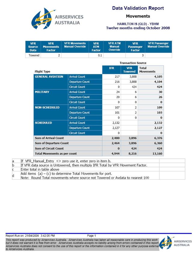
Office of Airspace Regulation                                                           Page 8 of 39

3.2.2. Aprons and Taxiways
Hamilton Island has one main apron, located in front of the terminal building and a
number of secondary parking areas.

The aerodrome has a network of five taxiways (designated as Alpha; Bravo; Charlie;
Delta and Echo). Taxiways Alpha and Bravo lead directly from the runway to the
main terminal apron. Taxiway Echo leads to a separate apron referred to as the
northern apron or area Echo.

                 Figure 3: Diagram of Hamilton Island aerodrome depicting apron,
      terminal building and taxiway network (from the DAP Chart – effective 30 August 2007)

The taxiway network has a number of limitations. Taxiway Charlie is not available to
aircraft above 5,700 kilograms (kg) Maximum Take Off Weight (MTOW). Taxiway
Delta is not available to aircraft above 36,000 kg MTOW. Taxiway Echo is not
available to aircraft with a wingspan greater than 15 metres. The absence of a full
length, parallel taxiway results in traffic entering and backtracking the runway prior to
departure (if using runway 32) and to backtrack after landing (if using runway 14).

A Passenger Transport (PT) aircraft may occupy the runway for up to 4 minutes
whilst it backtracks and prepares to take-off. Turning nodes are provided at each
threshold, and must be used by aircraft over 23,000kg MTOW.

3.2.3. Automatic Weather Information Service
Current meteorological information can be obtained through the Automated Weather
Information System (AWIS). The AWIS information can be acquired by telephoning
the service on: 07 4946 9043.
3.2.4. Navigational Aids
Hamilton Island is serviced by the following navigational aids (NavAids):

  •    A Non-Directional Beacon (NDB).
  •    A VHF Omni-Directional Radio Range (VOR).
  •    A Distance Measuring Equipment (DME) system.

The NDB is located on the aerodrome, on the western side of the runway. The VOR
and DME are located on top of the hill, to the East of the aerodrome.

Airspace Review – Hamilton Island (YBHM) – July 2009                                            Final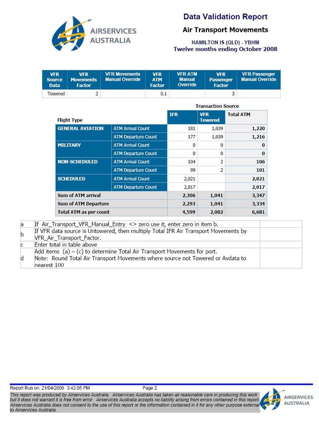
Office of Airspace Regulation Page 9 of 39
3.2.5. Landing Aids
• Precision Approach Path Indicator (PAPI) system is installed on both sides of
Runway 14 and Runway 32.
• Two illuminated Wind Direction Indicators (WDI), located on the left hand side
of the runway, adjacent to each threshold.
• Numerous red beacons have been installed on surrounding hills and islands to
warn pilots of high terrain.
3.2.6. Instrument Approaches
• Runway aligned, NDB and Area Navigation (RNAV) Global Navigation Satellite
System (GNSS) approaches are published for runway 14.
• Non-runway aligned, VOR approaches are published for runway 14 and 32.
• Non-runway aligned, Area Navigation (RNAV) Global Navigation Satellite
System (GNSS) approach is published for runway 32.
• Circling instrument approaches are also published for DME and Global
Positioning System (GPS) arrivals.
3.2.7. Radio Communications / Facilities
The Hamilton Island tower utilises the radio frequency of 118.7 megaHertz (MHz).
The frequency of 127.85 MHz is used outside tower hours to facilitate CTAF (R)
procedures at the aerodrome.
The current operational hours for the tower are 2300-0000 and 0100 - 0515
Coordinated Universal Time (UTC) daily. The UTC time equates to 0900 – 1000
and 1100 –1515 (Local time).
The air traffic services / flight information area frequency of 135.5 MHz can be
received on the ground and in the circuit, outside tower hours.
An Automatic Terminal Information Service (ATIS) is broadcast on the frequency
114.4 MHz.
3.2.8. Improvements / Developments
The aerodrome operator has stated that there are no plans for any major works or
for an increase in capacity at the aerodrome, as the current economic crisis has
resulted in a small drop in passenger numbers.
3.2.9. Local Traffic Regulations
• Right hand circuits are required when operating on runway 14.
• Due to pavement disturbance, aircraft above 23,000kg MTOW must use
runway turning nodes for 180 degree turns, unless directed by air traffic control.
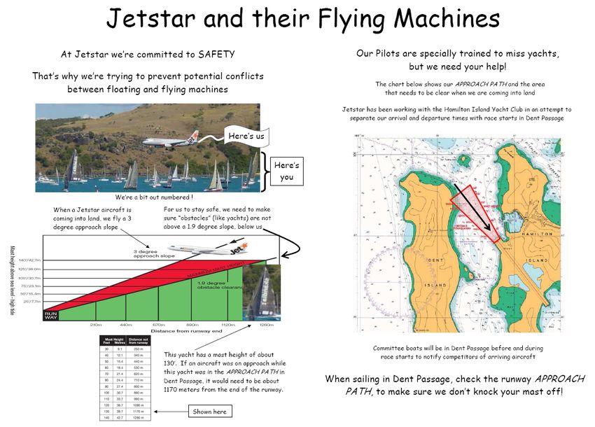
• Transient yacht masts may infringe both runway approach slope clearances.
• Training approval must be gained for operations during tower hours.
• Parachute operations take place within 5 nm of the island, up to 10,000 ft
AMSL.
• Skeet shooting range adjacent to runway 32 threshold.
• Bird hazard exists.
Airspace Review – Hamilton Island (YBHM) – July 2009 Final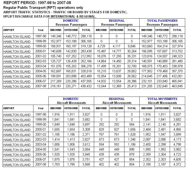
Office of Airspace Regulation                                                        Page 10 of 39

3.2.10. Radar Coverage and Surveillance
The OAR investigated the level of radar coverage surrounding Hamilton Island and
the option of classifying the airspace as Class E. Radar coverage below 3,000 ft
AMSL is not adequate to provide the necessary level of surveillance required. The
installation of additional infrastructure or technologies – such as “Multi-Lateration”
stations or ADS-B, would be required before Class E airspace could be classified
and introduced to the circuit height at Hamilton Island.

     Figure 4: Diagram showing radar coverage at 2,000 feet AMSL surrounding Hamilton Island

3.2.11. Additional aerodromes and helipads
There are numerous helicopter landing areas (helipads) within the Whitsunday
islands, many of which service island resorts. Some of the resorts with helipads,
within 20 nm of Hamilton Island are:
     • South Mole island
     • Daydream Island
     • Hayman Island
     • Happy Bay (Long Island)
     • Edward Island
     • Lindeman Island

There are two aerodromes within 20 nm of Hamilton Island. These are:
    • Shute Harbour / Whitsunday (Airlie Beach).
    • Lindeman Island.

Airspace Review – Hamilton Island (YBHM) – July 2009                                           Final
Office of Airspace Regulation Page 11 of 39 The Shute Harbour / Whitsunday aerodrome is an uncertified aerodrome, operated by the Whitsunday Airport Service. The aerodrome has one runway (designated as 14/32) which is 1100 metres long, and has an unrated, grass/gravel surface. The aerodrome is not serviced by any land based navigational aids. Aerodrome lighting is not available. During hours that Hamilton Island tower is active, the airspace around the Shute Harbour aerodrome is Class G from the surface to 1,500ft AMSL. Class D airspace exists between 1,500ft AMSL and 4,500ft AMSL. Class C airspace exists between 4,500ft AMSL and FL180. Class A airspace exists above FL180. Outside Hamilton Island tower hours, Class D airspace below 4,500ft AMSL is reclassified as Class G (i.e. uncontrolled) airspace. CTAF procedures are in operation at the aerodrome utilising the frequency 127.85 MHz. The aerodrome utilises an Aerodrome Frequency Response Unit (AFRU) which is also known as a "beepback" unit. The AFRU automatically responds to a radio broadcast to notify the pilot of the frequency used. The aerodrome has extensive ultralight and parachute operations. The Lindeman Island aerodrome is an uncertified aerodrome, operated by the Club Med Lindeman Island resort. The aerodrome has two runways. The main runway (designated as 18/36) is 1097 metres long, and has an unrated, grass surface. The second runway (designated as 13/31) is 680 metres long, and has an unrated, grass surface. The aerodrome is not serviced by any land based navigational aids. Aerodrome lighting is not available. The runways are not maintained and the aerodrome is not available to commercial aircraft. During hours that Hamilton Island tower is active, the airspace around Lindeman Island is Class D from the surface to 4,500ft AMSL. Class C airspace exists between 4,500ft AMSL and FL180. Class A airspace exists above FL180. Outside Hamilton Island tower hours, Class D airspace below 4,500ft AMSL is reclassified as Class G (i.e. uncontrolled) airspace. CTAF procedures are in operation at the aerodrome utilising the frequency 127.85 MHz. The Proserpine / Whitsunday Coast aerodrome is approximately 24 nm West South West of Hamilton Island. Whilst this is outside the scope of this review, the following details are included for completeness. The Proserpine/Whitsunday Coast aerodrome (hereafter referred to as “Proserpine”) is a certified aerodrome, operated by the Whitsunday Regional Council. The aerodrome has two runways. The main runway (designated as 11/29) is 2073 metres long, 45 metres wide and has a bitumen surface. The secondary runway (designated as 06/24) is 1100 metres long, 30 metres wide and has an unrated, bitumen surface. The runway 06/24 is not available to aircraft above 5,700 kg MTOW. Proserpine is serviced by NDB, VOR and DME Navigational Aids. An AWIS is available by telephoning 07 4945 5938 or via the radio on frequency 126.25 MHz. Airspace Review – Hamilton Island (YBHM) – July 2009 Final
Office of Airspace Regulation                                              Page 12 of 39

Pilot Activated Lighting is available on frequency 120.6 MHz. A PAPI system is
installed for use on the 11/29 runway. Lighting is not available on runway 06/24.

The airspace around Proserpine is Class G from the surface to 4,500ft AMSL. Class
C airspace exists between 4,500ft AMSL and FL180. Class A airspace exists above
FL180.

CTAF (R) procedures are in operation at the aerodrome. The aerodrome utilises an
Aerodrome Frequency Response Unit (AFRU) which is also known as a "beepback"
unit. The AFRU automatically responds to a radio broadcast to notify the pilot of the
frequency used.

The aerodrome is serviced by Virgin Blue Airlines and Jetstar Airways, with daily
flights to Brisbane.

4. Stakeholder Consultation
OAR representatives sought input from a number of stakeholders who operate in
and around Hamilton Island aerodrome. Stakeholder interviews were conducted
over the period of April and May 2009.

4.1 Internal
CASA employs Aviation Safety Advisors (ASA) throughout Australia as an integral
mechanism for providing safety promotion and educational material to the various
industry segments. CASA Aviation Safety Advisors liaise with local operators, and
discuss airspace issues. Feedback from the Aviation Safety Advisors is included in
this report.

4.2 Aerodrome Operator
The operator has reported that Jetstar has recently dropped one of its two daily
flights to Sydney. Jetstar have also recently dropped its flights to Melbourne on
Tuesdays and Wednesdays. It is understood that Virgin Blue will pick up one of
these flights. Virgin Blue plan to commence a daily flight to Sydney from the 4th July
this year. The operator has no plans for any major works or to increase the capacity
of the aerodrome, due to the current economic crisis, which has resulted in a small
drop in passenger numbers.

4.3 Passenger Transport Operators
OAR representatives sought input from the Passenger Transport (PT) operators who
operate in and around Hamilton Island aerodrome. Stakeholder interviews were
conducted over the period of April and May 2009.

4.3.1 VIRGIN BLUE AIRLINES
The controlled airspace in and around Hamilton Island is adequate for the
company’s operations. The airline is satisfied with the facilities provided by the
Great Barrier Reef Airport Pty Ltd.

Airspace Review – Hamilton Island (YBHM) – July 2009                               Final
Office of Airspace Regulation                                                 Page 13 of 39

4.3.2 JETSTAR AIRWAYS
The company are satisfied with the ground facilities at the aerodrome (taxiways /
apron / NavAids) and understand limitations due to the confined area available.

The company raised a number of traffic management issues and have implemented
a few company procedures to manage these:

     •    DME arrival from the South: Flights have planned for a DME arrival for a
          circling approach to runway 14 and at times the cloud base was lower than
          advertised. The resulting low level circling lead to some Ground Proximity
          Warning System (GPWS) alerts. The company therefore only descend to
          3,000ft on this DME arrival. If not visual by 3,000ft the flight would continue
          overhead the aerodrome, for the VOR approach.
     •    Dent Island: Jetstar have included information in their route manual to avoid
          Dent Island whilst in the circuit area of Hamilton Island.
     •    Yacht masts: The masts of transient yachts infringe the approach slope
          clearance for runways 14/32 which has resulted in aircraft conducting missed
          approaches. Jetstar have worked with the yacht club to educate sailors on
          the effects of their masts being inside the approach splay and the effects of
          wake turbulence/jet blast on them. An information pack has been developed
          and is available at the yacht club. A selection of Jetstar Airlines information
          flyers are attached in Annex H.

4.3.3 QANTASLINK
The airline is satisfied with the airspace surrounding Hamilton Island. They
experience some frustration with regard to the operating times of the tower, but
understand the hours are linked to the ferry service timetable to the mainland.
The morning flight to and from Cairns operates prior to the Hamilton Island tower
opening.

4.3.4 OTHER AIRLINES
A number of airlines are able to operate into Hamilton Island, but do not have
regular flights. These airlines include:
     • Air National (New Zealand)
     • Alliance Airlines Pty Ltd
     • AirNorth
     • National Jet Systems Pty Ltd

4.4 Military
The Military have no significant aviation activities at Hamilton Island.

4.5 Airservices Australia
The only issue raised was the occasional yacht transiting in and out of the marina
and the mast getting close to the aircraft approach paths. The situation is known to
the Airservices Australia (Airservices) tower staff; the Hamilton Island Marina
management and the airlines. It is being appropriately managed.

The OAR was able to access the Electronic Safety Incident Reports (ESIR) held by
Airservices and the records of flight information relating to Hamilton Island.

Airspace Review – Hamilton Island (YBHM) – July 2009                                  Final
Office of Airspace Regulation Page 14 of 39
5. Summary of Incidents and Accidents
5.1 Electronic Safety Incident Reports
During the 2008 calendar year, 49 Electronic Safety Incident Reports (ESIR) were
submitted to Airservices for the airspace surrounding Hamilton Island. Of the
reported incidents, five groups are related to airspace issues:
Number of
Type of Incident
Incidents
Violation of Controlled Airspace 16
Failure to comply with ATS instructions or procedures 8
TCAS Resolution 3*
Go around 3
Runway Incursion 2
Loss of Separation Assurance 1
Table 1: Breakdown of ESIRs at Hamilton Island (1st January 2008 – 31st December 2008)
*Note: Seven “Traffic Alert and Collision Avoidance System (TCAS) Resolution”
reports were recorded which included duplicate reports (multiple entries) of the same
incident.
26 of the 49 incidents relate to failure of the pilot to comply with instructions or
procedures (Violation of Controlled Airspace/ Runway Incursion/ Failure to comply
with ATS instructions or procedures). While this represents over half of all of the
incidents reported, it should be noted that 49 reported incidents equates to 0.37% of
the total movements into Hamilton Island.
Three go-around (missed approaches) were recorded during the 2008 calendar
year. Two were initiated due to wind sheer and one was due to the mast of a
transient yacht infringing the approach slope clearance for runway.
Each incident has been investigated, or is currently being investigated by Airservices
or CASA. In each case, the pilot in command will be contacted and educated
regarding the correct procedures relating to the incident.
5.2 Air Safety Incident Reports
All accidents and incidents involving Australian registered aircraft, or foreign aircraft
in Australian airspace must be reported to the Australian Transport Safety Bureau
(ATSB). The ATSB maintains its own database (Occurrence Analysis and Safety
Information System) in which all reports assessed by the ATSB as an accident,
incident or serious incident are recorded. Each individual report is known as an Air
Safety Incident Report (ASIR) and for identification purposes is allocated its own
serial number.
During the calendar year, 34 Aviation Safety Incident Reports (ASIR) were submitted
to the ATSB for the airspace surrounding Hamilton Island.
Number of
Type of Incident
Incidents
Violation of Controlled Airspace 19
Failure to comply with ATS instructions or procedures 4
Loss of Separation Assurance 1
Table 2: Breakdown of ASIRs at Hamilton Island (1st January 2008 – 31st December 2008)
Airspace Review – Hamilton Island (YBHM) – July 2009 FinalOffice of Airspace Regulation Page 15 of 39 The difference in numbers between ESIRs and ASIRs can be attributed to the different way in which incidents are categorised. For example: if a pilot is given a clearance to taxi to the runway holding point, but continues and takes off, the ESIR may classify the incident as a “Failure to comply with ATS instructions or procedures”, as this was the first error made. The ASIR may class the incident as a “Violation of Controlled Airspace”, as this was the end result of the error. A summary of the ASIRs can be found in Annex G. 6. Modelling Methodology and Risk Assessment 6.1 Methodology Outline The OAR used the Airspace Risk Model (ARM) to model the airspace surrounding the Hamilton Island aerodrome. The ARM and a FN-curve was developed by CASA and utilised by the OAR. CASA has developed ‘acceptable risk’ criteria with regard to the risk of midair conflicts within regional aerodrome terminal areas. The collision risk model, developed by CASA in 1996, is focused on a non-radar controlled terminal area model and no significant changes have been made since its development and presentation to the Review of the General Concept of Separation Panel, now the Separation and Airspace Safety Panel of the International Civil Aviation Organization (ICAO). This method includes the ARM, which is used to calculate benefits in terms of fatalities avoided by implementing safety measures. The ARM presumes that there is a ‘Potential Conflict Pair’, i.e. a pair of aircraft whose manoeuvres are such that if no intervening action is taken, the aircraft will reach a point where it will be too late to take evasive action and chance becomes the determining factor in whether the aircraft collide or not. This is called the Loss of Control point in this review. The ARM model is based on the Linear Criterion concept which stipulates that the frequency of an accident should be inversely proportional to its severity, i.e. an accident involving one fatality may happen ten times as often as an accident involving ten fatalities. 6.2 Airspace Risk Assessment 6.2.1. Assumptions The operational environment referred to in the model is controlled non-radar, Class D terminal area. It has a radius of 15 nautical miles and extends to 5,000 ft above ground level. 6.2.2. Summary of Movement Data A summary of aerodrome operator passenger movements is given in Table 1. Aircraft movement data and passenger movements in charter or private aircraft is not recorded by the airport operator. The total passenger numbers recorded by the aerodrome operator each year only represents those passengers that transit through the airport on RPT, this data being provided by the airlines on a monthly basis. Therefore the aerodrome operator passenger movement data is statistically similar to the Bureau of Infrastructure, Transport and Regional Economics (BITRE) data recorded for the same periods. Airspace Review – Hamilton Island (YBHM) – July 2009 Final
Office of Airspace Regulation                                                            Page 16 of 39

BITRE passenger movement and aircraft movement numbers summarised in Table
1 and 2 was sourced from their website2, an extract of which can be found at
Annex F. This data is similar to the aerodrome operator data in that it only captures
passenger and aircraft movement numbers from scheduled RPT services at the
subject airport. As with the aerodrome operator it is not thought that this data
accurately takes into account private or charter passenger aircraft movements.

Airservices data was sourced using their Aerodrome Research Application (ARA)
tool. Detailed ARA data for the 12 months ending October 2008 can be found at
Annex E.

The ARA data differs from the previously mentioned sources in that it generally
involves a more comprehensive data gathering process that includes assessment
and use of BITRE data. ARA data captures passenger and traffic movements
involved in private and charter flights, plus includes circuit movements in the overall
movement totals.

                                 Year            Year       Year           Year           Year
      Data Source
                                2003/04         2004/05    2005/06        2006/07        2007/08
      Aerodrome
       Operator                 343,277         365,009    443,143        476,917        473,611
     % growth on
                                21.06%           6.33%     21.41%          7.62%         -0.69%
     previous year
         BITRE                  338,978         357,370    432,051        465,941        463,845
     % growth on
                                20.43%           5.43%     20.90%          7.84%         -0.45%
     previous year
      Airservices
                                   -                   -       -              -          452,452
       Australia
                 Table 3: Passenger numbers for Hamilton Island – previous 5 years.

                                 Year            Year       Year           Year           Year
    Data Source
                                2003/04         2004/05    2005/06        2006/07        2007/08
       BITRE                     4,798           3,982      4,723           4,605         4,372
    % growth on
     previous                   14.98%         -17.01%     18.61%          -2.50%         -5.06%
        year
    Airservices
                                   -                   -      -               -           6,681
     Australia
             Table 4: Passenger Transport Service movements for Hamilton Island – previous 5 years.
The above Table 3 and Table 4 show clearly that passenger numbers remain steady
whilst the PTS movements have declined. The average number of passengers per
PTS movement has increased from approximately 70.6 in 2003/04 to 106.1 in
2007/08, indicating that the capacity of aircraft flying into Hamilton Island has
increased.

For the purpose of this review the Airservices data set for the 12 months up to
October 2008 has been used, as it more accurately represents the true total air
transport service movements inclusive of circuits.

2
    To view http://www.bitre.gov.au/publications/91/Files/Airport%20traffic%20tables%20Web.xls
Airspace Review – Hamilton Island (YBHM) – July 2009                                             Final
Office of Airspace Regulation Page 17 of 39
6.2.3. Estimated Traffic Mix
A brief summary of the estimated traffic mix utilising Airservices data at Hamilton
Island is shown in Table 5. The data differentiates between VFR flights and those
conducted under Instrument Flight Rules (IFR).
No of % of
Traffic Type
movements movements
VFR Light 6,225 47.30%
IFR Light 2,708 20.58%
IFR Medium 203 1.54%
IFR Heavy 4,024 30.58%
Total 13,160 100.00%
Table 5: Traffic mix for Hamilton Island aerodrome
Traffic Mix for Hamilton Island
VFR
IFR - L
IFR - M
IFR - H
Figure 5: Graphical breakdown of traffic mix at Hamilton Island aerodrome
As can be seen from Table 5 and Figure 5 the majority of aircraft movements are by
VFR aircraft with IFR light and medium aircraft.
Airspace Review – Hamilton Island (YBHM) – July 2009 FinalOffice of Airspace Regulation Page 18 of 39
6.2.4. Collision pairs were calculated applying the CASA collision formula
Conflict pairs were grouped into 16 categories and are listed in Table 6:
Collision
Collision Types
Pairs
VFR - VFR 45
IFR( L) - VFR 17
IFR(L) - IFR(L) in VMC 7
IFR(L) - IFR(L) in IMC 2
IFR (M) - VFR 1
IFR(M) - IFR(L) in VMC 0
IFR(M) - IFR(L) in IMC 0
IFR(M) -IFR(M) in VMC 0
IFR(M) -IFR(M) in IMC 0
IFR(H) - VFR 26
IFR(H) - IFR(L) in VMC 9
IFR(H) - IFR(L) in IMC 2
IFR(H) - IFR(M) in VMC 1
IFR(H) - IFR(M) in IMC 0
IFR(H) - IFR(H) in VMC 15
IFR(H) - IFR(H) in IMC 4
Table 6: Estimated collision pairs for Hamilton Island
VFR including gliders and helicopters
IFR (L) = IFR Light - less than 10 passengers
IFR (M) = IFR Medium - 10 to 38 passengers
IFR (H) = IFR High - more than 38 passengers
The conflict pairs were grouped in proportion to traffic and in addition the following
assumptions were made:
• Factor up like pairs by 1½
• Factor down unlike pairs by ⅔
• IFR-IFR pairs are 80% in VMC and 20% in IMC
• In total 129 collision pairs were estimated.
6.2.5. Evaluation of Airspace Models and Data Analysis Results
Annualised total traffic movement data was applied to the ARM developed by CASA.
The results are shown in Figure 6 – Risk Model.
The following scenarios were considered for Hamilton Island:
• CTAF (R) procedures (pink line)
• Class D tower (blue line)
Class E airspace was not considered because of the higher Class D classification
that was in place.
Airspace Review – Hamilton Island (YBHM) – July 2009 FinalOffice of Airspace Regulation Page 19 of 39 The blue line represents a Class D tower service for Hamilton Island. This line is well below the scrutiny line and it is reasonable to assume that if all services applicable to a Class D tower are in place, that Hamilton Island can be considered to be as low as reasonably practicable (ALARP). Therefore the risks associated with Hamilton Island are tolerable. It should be noted that CTAF(R) procedures are in place at Hamilton Island during periods of reduced RPT activity. During periods of decreased activity, the CTAF(R) procedures offer adequate safety mitigation measures for the aerodrome. The modelling results estimate that with a Class D tower service approximately, 0.006549 fatalities per annum can be expected. In addition, it is estimated that Hamilton Island has a likelihood of having one midair collision approximately every 10,707 years with an estimate of 70 fatalities. Airspace Review – Hamilton Island (YBHM) – July 2009 Final
Office of Airspace Regulation                                                                                                                           Page 20 of 39

                                                                                                                                           Acceptable Risk
                                                                                           Hamilton Island
                                                                                                                                               Criteria

                                                                  1

                                                                                                                                      1
                                                                                                                                    0.1
                                                                                                                                    0.01
                                                                 0.1
                                                                                                                                  0.001
                                                                                                                                 0.0001
                                                                                                                               0.00001
                                                                                                                              0.000001

                                                                0.01
      Annual Frequency of N or More Fatalities (Likelihood)

                                                               0.001

                                                                                                                                                Intolerable Risk Line

                                                              0.0001

                                                                                                                                                  Scrutiny Risk Line
                                                   0.00001

                    0.000001
                                                                                                                                                 Middle ALARP Line

     0.0000001
                                                                                                                                               Acceptable Risk Line
                                                                       1                  10                 100                    1000
                                                                                         Fatalities (Consequence)

                                                                       D Tower                                      CTAF(R)

                                                                           Figure 6: Results of the Airspace Risk Model for Hamilton Island

Note: The Scrutiny Line for CTAF(R) procedures depicted in Figure 6 assumes that
CTAF (R) procedures are in place 24 hours a day.

Airspace Review – Hamilton Island (YBHM) – July 2009                                                                                                              Final
Office of Airspace Regulation Page 21 of 39
7. Findings
7.1 Feedback from the RPT stakeholders was positive toward the facilities and
airspace architecture.
7.2 The application of the Airspace Risk Model (ARM) revealed that the current
situation lies close to the ‘as low as reasonably practicable’ (ALARP) region and
that Class D airspace (and CTAF (R) procedures outside tower hours), should
be the minimum service level maintained at the Hamilton Island aerodrome.
7.3 The introduction of Class E airspace to the circuit height is not acceptable with
the current level of radar coverage. The installation of additional infrastructure
or technologies would be required before Class E airspace can be lowered to
the circuit height.
8. Recommendations
8.1 The report makes the following recommendations:
1. Based on current aircraft movements, no change be made to the airspace
structure surrounding Hamilton Island.
2. The OAR maintain a watch of activity at Hamilton Island aerodrome during
the bi-annual review of movement data, and, if total aircraft movements
significantly increase, or after five years, whichever occurs first, an
aeronautical study should be conducted to reassess the risk to passenger
transport operations.
Airspace Review – Hamilton Island (YBHM) – July 2009 FinalOffice of Airspace Regulation Page 22 of 39
Annexes:
A. Acronyms
B. Australian Airspace Structure
C. Stakeholders
D. Aerodrome Operator Data
E. Airspace Research Application (ARA) Data
F. Bureau of Infrastructure Transport and Regional Economics (BITRE) Data
G. Australian Transport Safety Bureau (ATSB) Data
H. Jetstar Airlines information flyers
Airspace Review – Hamilton Island (YBHM) – July 2009 FinalOffice of Airspace Regulation Page 23 of 39
Annex A – Acronyms
AAPS Australian Airspace Policy Statement, 28 June 2007
ACAS Airborne Collision Avoidance System
ACP Airspace Change Proposal
Act Australian Airspace Act 2007
AIP Aeronautical Information Publication
AIRPROX Close proximity event between two aircraft
Airservices Airservices Australia
ALARP As Low As Reasonably Practicable
AMSL Above Mean Sea Level (in feet)
ARA Airspace Research Application
ARM Airspace Risk Model
ASA Aviation Safety Advisor (CASA)
ASIR Aviation Safety Incident Report
ATC Air Traffic Control
ATI Air Transport Inspector
ATIS Aerodrome Terminal Information Service
ATOG Air Transport Operations Group (CASA)
ATS Air Traffic Services
ATSB Australian Transport Safety Bureau
AWIS Automatic Weather Information Service
BITRE Bureau of Infrastructure, Transport and Regional Economics
(Department)
CAR Civil Aviation Regulations 1988
CASA Civil Aviation Safety Authority
CASR Civil Aviation Safety Regulations 1998
CBA Cost Benefit Analysis
CBS Checked Baggage Screening
CHTR Charter
CTAF Common Traffic Advisory Frequency
CTAF(R) Common Traffic Advisory Frequency (Radio Required)
CTA Controlled Airspace
CTR Control Zone
DA Danger Area
DAP Departure and Approach Procedures (AIP)
DCEO Deputy Chief Executive Officer
Defence Department of Defence
DME Distance Measuring Equipment
ERSA En Route Supplement of Australia
ESIR Electronic Safety Incident Report
FIDS Flight Information Display System
FIR Flight Information Region
FIS Flight Information Service
FL Flight Level
FN Curve Frequency /Severity Risk Curve
FOI Flying Operations Inspector
ft Feet
GA General Aviation
GAAP General Aviation Aerodrome Procedures
GAOG General Aviation Operations Group (CASA)
Airspace Review – Hamilton Island (YBHM) – July 2009 FinalOffice of Airspace Regulation Page 24 of 39
GGM Group General Manager
GNSS Global Navigation Satellite System (Navigational Aid)
GPS Global Positioning System
GPWS Ground Proximity Warning System
IAS Indicated Airspeed
ICAO International Civil Aviation Organization
IFR Instrument Flight Rules
IFR (H) IFR Heavy - more than 38 passengers
IFR (L) IFR Light - less than 10 passengers
IFR (M) IFR Medium - 10 to 38 passengers
IMC Instrument Meteorological Conditions
kg kilograms
kts knots ( nautical miles per hour)
MAC Mid-Air Collision
MBZ Mandatory Broadcast Zone
MHz megaHertz
MOS Manual of Standards
MTOW Maximum Take Off Weight
NavAid Navigational Aid
NDB Non-Directional Beacon (Navigational Aid)
nm nautical miles
NOTAM Notice to Airmen
OAR Office of Airspace Regulation (CASA)
OCTA Outside of Controlled Airspace
PA Prohibited Area
PAL Pilot Activated Lighting
PAPI Precision Approach Path Indicator
PT Passenger Transport
PTS Passenger Transport Service
QNH An altimeter subscale setting to obtain elevation or altitude
R/T Radio Telephony
RA Restricted Area
REX Regional Express Airlines
RGCSP Review of the General Concept of Separation Panel
RIS Radar Information Service
RNAV Area Navigation
RPT Regular Public Transport
RWY Runway
SAR Search and Rescue
SFC Surface
SVFR Special Visual Flight Rules
TCAS Traffic Alert and Collision Avoidance System, a type of ACAS
TWR Tower
VFR Visual Flight Rules
VHF Very High Frequency (radio)
VIS Visibility
VMC Visual Meteorological Conditions
VOR Very High Frequency (VHF) Omni-directional Radio Range
VTC Visual Terminal Chart (AIP)
WDI Wind Direction Indicator
Airspace Review – Hamilton Island (YBHM) – May 2009 FinalOffice of Airspace Regulation Page 25 of 39
Annex B – Australian Airspace Structure
Class Description Services/Procedures/Rules
All airspace above Fight Level IFR only, all separated by Air Traffic Control (ATC), no speed limitation, continuous two-way radio required.
A (FL) 180 (East Coast) or Clearance required from ATC to enter airspace.
FL245
B Not currently used in Australia
IFR separated from IFR, VFR and Special VFR (SVFR) by ATC, no speed limitation for IFR operations,
continuous two-way radio required. Clearance required from ATC to enter airspace.
In control zones (CTRs) of VFR receives traffic information on other VFR but not separated from each other by ATC. Speed limited to
defined dimensions and 250knots (kts) Indicated Air Speed (IAS) below 10,000ft AMSL*, continuous two-way radio required. Clearance
C control area steps associated required from ATC to enter airspace.
with controlled aerodromes Special VFR separated from Special VFR when visibility (VIS) is less than VMC. Speed limited to 250kts IAS below
10,000ft AMSL*, continuous two-way radio required. Clearance required from ATC to enter airspace.
Transponder required within radar coverage.
IFR separated from IFR and Special VFR. Traffic information provided on all VFR. Speed limited to 250kts IAS
below 10,000ft AMSL*, continuous two-way radio required. Clearance required from ATC to enter airspace.
Regional locations such as VFR receives traffic on all other aircraft but not separated by ATC. Speed limited to 250kts IAS below 10,000ft
D Hobart and Alice Springs AMSL*, continuous two-way radio required. Clearance required from ATC to enter airspace.
Special VFR separated from Special VFR when VIS is less than VMC. Speed limited to 250kts IAS below 10,000ft
AMSL*, continuous two-way radio required. Clearance required from ATC to enter airspace.
GAAP:
• In VMC all operations are VFR, traffic information only. Speed limited to 250kts IAS, continuous two-way radio
required. Clearance required from ATC to enter airspace.
D High density General Aviation
• In IMC, IFR separated from all traffic. Speed limited to 250kts IAS, continuous two-way radio required. Clearance
(GAAP) aerodromes
required from ATC to enter airspace.
• Special VFR separated from Special VFR when VIS is less than VMC. Speed limited to 250kts IAS, continuous
two-way radio required. Clearance required from ATC to enter airspace.
IFR separated from IFR by ATC, traffic information on known VFR. Speed limited to 250kts IAS below 10,000ft
Controlled airspace not AMSL*, continuous two-way radio required. Clearance required from ATC to enter airspace.
covered in classifications VFR provided with Flight Information Service (FIS), search and rescue (SAR), weather update service, on request,
E above (above 8,500ft or within radar coverage and workload permitting. Speed limited to 250kts IAS below 10,000ft AMSL*, continuous
FL180) two-way radio required. Clearance from ATC to enter airspace not required.
Transponder required for VFR aircraft with continuous electrical power
F Not currently used in Australia
IFR receives FIS on IFR and known VFR traffic. Speed limited to 250kts IAS below 10,000ft AMSL*, continuous
two-way radio required. Clearance from ATC to enter airspace not required.
VFR provided with FIS, SAR, weather update service and Radar Information Service (RIS) subject to availability.
G Non-controlled
Speed limited to 250kts IAS below 10,000ft AMSL*. Clearance to enter airspace from ATC not required. VHF radio
required above 5,000ft AMSL and at aerodromes where carriage and use of radio is required. VHF radio for
operations in VMC.
* Not applicable to military aircraft
Airspace Review – Hamilton Island (YBHM) – July 2009 FinalOffice of Airspace Regulation
Annex C – Stakeholder input provided by:
Position Organisation
Aerodrome Manager Great Barrier Reef Airport Pty Ltd (Aerodrome Operator)
Aerodrome and Airways Manager Jetstar Airways
Manager Regulatory Affairs QantasLink Airways
E-Jet Fleet Standards Manager Virgin Blue Airlines
Information and Co-ordination Officer Australian Transport Safety Bureau
Senior Defence Advisor Department of Defence
Regulatory Services Manager Airservices Australia
Aviation Safety Advisor (ASA) Deputy Chief Executive Officer, Operations, CASA
Flying Operations Inspector (FOI) General Aviation Operations Group, CASA
Airspace Review – Hamilton Island (YBHM) – July 2009 FinalOffice of Airspace Regulation Page 27 of 39
Annex D – Aerodrome Operator Data
2003 / 2004 2004 / 2005 2005 / 2006 2006 / 2007 2007 / 2008
ARRIVALS DEPARTURES ARRIVALS DEPARTURES ARRIVALS DEPARTURES ARRIVALS DEPARTURES ARRIVALS DEPARTURES
July 12,696 13,307 14,421 15,322 16,443 17,418 20,763 22,017 19,174 20,275
August 14,720 14,498 15,971 15,281 17,556 17,466 19,930 19,339 21,213 20,256
September 16,862 15,358 18,564 17,142 20,989 18,948 23,692 22,126 23,684 22,807
October 17,221 18,669 19,346 20,590 22,139 23,340 24,429 25,478 24,445 25,560
November 15,801 16,081 15,543 16,195 19,605 20,099 21,681 22,148 22,481 22,618
December 15,679 13,863 16,152 14,002 20,061 17,942 20,982 19,500 21,334 20,171
January 16,182 18,987 15,857 18,274 21,329 24,435 20,724 23,899 19,716 22,921
February 11,005 11,422 11,462 11,347 14,449 14,355 15,400 15,021 15,431 15,410
March 12,801 12,686 15,361 14,422 17,770 17,452 18,665 18,443 19,667 19,248
April 14,257 14,297 14,899 15,127 19,927 20,052 18,802 19,355 18,162 18,623
May 10,922 11,381 11,971 12,928 14,990 15,648 15,737 15,826 15,328 16,106
June 12,746 11,836 13,339 11,493 16,124 14,606 16,648 16,312 15,130 13,851
Sub Total 170,892 172,385 182,886 182,123 221,382 221,761 237,453 239,464 235,765 237,846
Total Movements 343,277 365,009 443,143 476,917 473,611
Airspace Review – Hamilton Island (YBHM) – July 2009 FinalOffice of Airspace Regulation Page 28 of 39
Annex E – Airservices Australia Data
Airspace Review – Hamilton Island (YBHM) – July 2009 FinalOffice of Airspace Regulation Page 29 of 39
Annex E – Airservices Australia Data (Continued)
Airspace Review – Hamilton Island (YBHM) – July 2009 FinalOffice of Airspace Regulation Page 30 of 39
Annex E – Airservices Australia Data (Continued)
Airspace Review – Hamilton Island (YBHM) – July 2009 FinalOffice of Airspace Regulation Page 31 of 39
Annex F – BITRE Data
Airspace Review – Hamilton Island (YBHM) – July 2009 FinalOffice of Airspace Regulation Page 32 of 39
Annex F – BITRE Data (Continued)
HAMILTON ISLAND
500
450
Total Revenue Passengers
400
350
300
(thousand)
250
200
150
100
50
0
1997- 1998- 1999- 2000- 2001- 2002- 2003- 2004- 2005- 2006- 2007-
98 99 00 01 02 03 04 05 06 07 08
Financial Year
Passenger numbers 1997 - 2008
HAMILTON ISLAND
6,000
Total Aircraft Movements
5,000
4,000
3,000
2,000
1,000
0
1997- 1998- 1999- 2000- 2001- 2002- 2003- 2004- 2005- 2006- 2007-
98 99 00 01 02 03 04 05 06 07 08
Financial Year
Air Transport movements 1997 - 2008
Airspace Review – Hamilton Island (YBHM) – July 2009 FinalOffice of Airspace Regulation Page 33 of 39
Annex G – ATSB Data
ATSB
Occurrence Airspace Airspace Aircraft
Reference ATSB Summary Incident Type
Date Type Class Model
Number
200800128 04-Jan-08 CTR D Vehicle A vehicle entered the runway without a clearance. Failure to comply with ATS instructions
200800494 03-Feb-08 CTR D R44 II The helicopter became airborne from the apron without a clearance. Violation of Controlled Airspace
200800781 07-Feb-08 CTR D A320-232 During the landing roll, the aircraft struck a duck. Birdstrike
On opening of the tower, multiple failures of tower equipment was
200803279 10-Feb-08 CTR D n/a Information Delivery/Display Error
observed.
Just prior to commencing an instrument approach, the crew noticed
that the number one primary flight display showed an incorrect IAS.
200800951 16-Feb-08 CTA C A320-232 Misc.
The instrument was restored using an alternate source and the
aircraft landed safely.
The helicopter entered the CTR without a clearance and was first
200801104 21-Feb-08 CTR D R44 II noticed on short final by the tower controller. No broadcasts or other Violation of Controlled Airspace
calls were made by the pilot.
The aircraft entered the CTR without a clearance and the pilot
200801497 08-Mar-08 CTR D R44 II Violation of Controlled Airspace
contacted ATC when on final approach to runway 14.
200801665 13-Mar-08 CTR D Vehicle A line-marking vehicle entered runway 14 without a clearance. Failure to comply with ATS instructions
The Hamilton Island PAPI (Precision Approach Path Indicator) failed
200801786 15-Mar-08 CTR C A320-232 while the aircraft was on final. The crew conducted a visual Misc.
approach.
The aircraft was observed turning final as the pilot contacted the
ADC to advise that they thought the aerodrome was operating as a
200801815 20-Mar-08 CTR D M20M Violation of Controlled Airspace
CTAF. No other calls had been heard on the CTAF(R) or Hamilton
Island tower frequencies from the pilot.
After the pilot reported inbound on the CTAF frequency, the ADC
47G3B-
200802330 07-Apr-08 CTR D advised that the controlled airspace was active. The helicopter Violation of Controlled Airspace
KH4
subsequently entered controlled airspace without a clearance.
Airspace Review – Hamilton Island (YBHM) – July 2009 FinalOffice of Airspace Regulation Page 34 of 39
DHC-2
200802611 19-Apr-08 CTR D The aircraft entered the CTR without a clearance. Violation of Controlled Airspace
MK 1
The pilot commenced the take-off run on runway 14 without a
200803291 18-May-08 CTR D A36 Violation of Controlled Airspace
clearance.
During the landing roll on runway 14, the aircraft struck a magpie
200803437 22-May-08 CTR D A320-232 Birdstrike
lark.
During the landing roll, the aircraft struck a swallow that impacted
200803597 30-May-08 CTR D A320-232 Birdstrike
the radome.
PA-23-
200803600 02-Jun-08 CTR D During the take-off run, the aircraft struck a plover. Birdstrike
250
PA-32- The aircraft was observed by ATC to have joined a right circuit,
200803601 02-Jun-08 CTR D Failure to comply with ATS instructions
300 contrary to instructions.
The pilot did not comply with the line up clearance and the aircraft
200803946 16-Jun-08 CTR D 208 Failure to comply with ATS instructions
became airborne without a clearance.
During the approach, the crew of an Airbus A320 reported receiving
200804029 18-Jun-08 CTA D A320-232 Loss of Separation Assurance
a TCAS RA after a VFR aircraft passed below the A320.
The aircraft entered controlled airspace before the pilot requested a
200804721 19-Jul-08 CTR D C130 Violation of Controlled Airspace
clearance.
200804984 30-Jul-08 CTR D R44 II The helicopter was observed by ATC to take off without a clearance. Violation of Controlled Airspace
The aircraft was observed by ATC to have commenced the take-off
200805168 10-Aug-08 CTR D 206L-3 Violation of Controlled Airspace
run without a clearance.
DHC-8-
200805210 13-Aug-08 CTR D During the initial climb, the aircraft struck a swallow. Birdstrike
315
The unidentified aircraft was observed by ATC to have entered
200805262 14-Aug-08 CTA D Unknown Violation of Controlled Airspace
controlled airspace without a clearance.
200805287 15-Aug-08 CTR D R44 II The helicopter took off without a clearance. Violation of Controlled Airspace
Airspace Review – Hamilton Island (YBHM) – July 2009 FinalOffice of Airspace Regulation Page 35 of 39
The aircraft was observed by ATC to have entered controlled
200805444 21-Aug-08 CTR D 172M Violation of Controlled Airspace
airspace without a clearance.
200805465 24-Aug-08 CTR D 206L-1 The helicopter was observed by ATC to take off without a clearance. Violation of Controlled Airspace
On short final approach, the crew commenced a go-around due to a
200805578 26-Aug-08 CTR D A320-232 Go Around
yacht moving through the undershoot area.
The helicopter entered controlled airspace prior to requesting an
200805541 26-Aug-08 CTR D R44 II Violation of Controlled Airspace
airways clearance.
The helicopter was observed by ATC to have entered controlled
200805644 30-Aug-08 CTR D R44 II Violation of Controlled Airspace
airspace and landed without a clearance.
During the descent, the aircraft was cleared to 3,900 ft. The aircraft
DHC-8-
200806011 13-Sep-08 CTA D was subsequently observed by ATC to have descended to 2,200 ft Failure to comply with ATS instructions
315
without a clearance.
47G3B- The helicopter was observed by ATC to have entered controlled
200806601 11-Oct-08 CTR D Violation of Controlled Airspace
KH4 airspace without a clearance.
While on descent, the pilot declared a PAN due to an engine
200807017 07-Nov-08 CTA C 182P Emergency Operations
problem. The aircraft was landed at Shute Harbour.
The aircraft was observed by ATC to have entered controlled
200807617 25-Nov-08 CTR D R44 II Violation of Controlled Airspace
airspace without a clearance.
DHC-8- During the landing roll, the aircraft struck a bird that impacted the
200807873 08-Dec-08 CTR D Birdstrike
402 left wing leading edge.
Airspace Review – Hamilton Island (YBHM) – July 2009 FinalOffice of Airspace Regulation Page 36 of 39
Annex H – Jetstar information flyers
Airspace Review – Hamilton Island (YBHM) – July 2009 FinalOffice of Airspace Regulation Page 37 of 39 Airspace Review – Hamilton Island (YBHM) – July 2009 Final
Office of Airspace Regulation                            Page 38 of 39

  Airspace Review – Hamilton Island (YBHM) – July 2009              Final
Office of Airspace Regulation                            Page 39 of 39

  Airspace Review – Hamilton Island (YBHM) – July 2009              Final
You can also read