Ajmer, Rajasthan MAPPING OF INFORMAL SETTLEMENTS IN - Study Report - Participatory ...
←
→
Page content transcription
If your browser does not render page correctly, please read the page content below
Study Report

    MAPPING OF
    INFORMAL SETTLEMENTS IN

    Ajmer, Rajasthan

0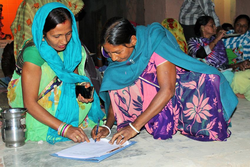
Participatory Research in Asia

       Content

        Content                                                                      Page

        A General Profile of Ajmer City                                              2
        A General Poverty Profile of Ajmer City                                      4
        Methodology for Listing of Informal Settlements                              5
        Status of Informal Settlements in Ajmer                                      6
        Challenges and Lessons Learned                                               11

        Annexures
        Annex.1: Format for Listing of Informal Settlements                          13
        Annex. 2: List of Informal Settlements based on Secondary Sources            15
        Annex.3: List of Informal Settlements Identified by the Mapping Exercise     17
        Annex. 4: List of CBOs in Various Informal settlements of Ajmer              20

        List of Charts, Tables, and Figures
        Chart 1: Status of Informal Settlements in Ajmer                             6
        Chart 2: Ownership of Informal Settlement Lands in Ajmer                     6
        Chart 3: Type of Area Surrounding the Informal Settlements in Ajmer          7
        Chart 4: Physical Locations of the Informal Settlements in Ajmer             7
        Chart 5: Locational Characteristics of Informal Settlements in Ajmer         8
        Chart 6: Type of Structures for Majority of Houses in Informal Settlements   8
        Chart 7: Approach Road to Informal Settlements in Ajmer                      9
        Chart 8: Type of Internal Roads in Informal Settlements of Ajmer             9
        Chart 9: Distance of Informal Settlements from Nearest Motorable Roads       10
        Chart 10: Presence of Public Institutions in Informal Settlements of Ajmer   10

        Table 1: Decadal Growth                                                      2
        Table 2: No. of Wards in Ajmer City                                          3

        Figure 1: Latest Map of Ajmer Showing Wards                                  3

   1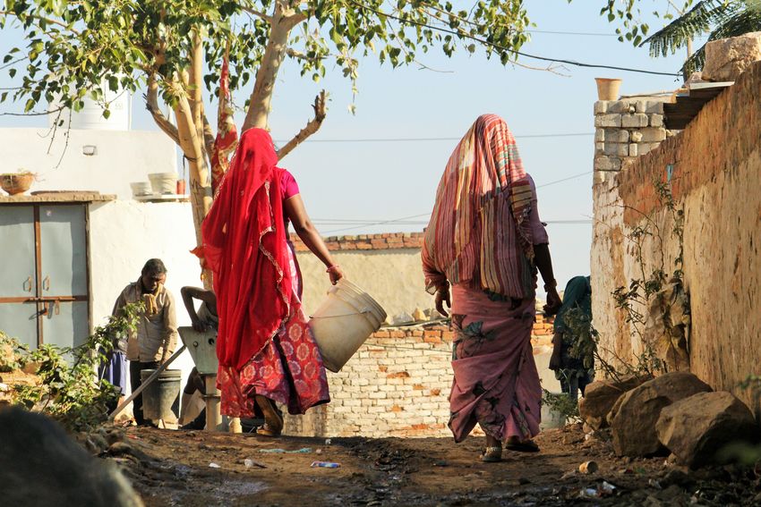
Study Report

A General Profile of Ajmer City

The city of Ajmer is called the heart of Rajasthan and is situated 130 kms. away from the state
capital Jaipur. The city has been significant in the state for historic, religious, and touristic
importance. There is a Dargah of Sufi saint Kwaja Moinudddin Chisti, which is popular among both
Hindus and Muslims. It is an important religious place for Jains. Swarna Nasiya is a Jain temple.
There are old Christian churches, and research and educational institutions of Arya Samaj and
Paropkarini Sabha. Swami Dayanand Saraswati lived and worked here.

The city has been an educational centre in the state and some of the famous educational
institutions include Mayo College, MDS University, Sofia College and Government College.
Administratively it is an important destination in the state as it has office of Revenue Board, Railway
Recruitment Board, Rajasthan Public Service Commission, and Board of Secondary Education. It
is an important city in the central Rajasthan and many of towns and rural areas are dependent on
Ajmer for administrative and essential services. It is an important location on Delhi-Mumbai
industrial corridor.

After the Independence refugees from Pakistan migrated to Ajmer and settled in different locations
of the city. Increasing population has forced for development in outer areas of the city, which is
sometimes haphazard and lacks basic services.

According to the 2011 Census, the average decadal growth rate of Ajmer between 1991-2001 was
20.5% and between 2001-2011, the growth rate was 13.4%. It is important to note that the
exceptional growth rate during 1991-2001 was because of extended municipal boundaries of Ajmer
Municipal Corporation. According to the census 2011, the population of Ajmer city is 542,580. The
projected population of Ajmer by 2020 is 620,155.

                                       Table 1: Decadal Growth

 Year                               Population                         Decadal Growth Rate %
 1981                               375,593                            42.11
 1991                               402,700                            07.22
 2001                               485,575                            20.58
 2011                               542,580                            11.74
Source: Urban Improvement Trust, Rajiv Awas Yojana, Slum Free Action Plan

Ajmer is a low density city with a highly dense inner core, with population density of over 5,000
persons/ sq. km. The Anasagar zone consisting of Anasagar area, Vaishali Nagar and
Chaurasiyawas have the lowest density of less than 2,000 persons/ sq. km. The gross average
density of the city is 5,750 persons/ sq. km.

The most densely populated wards are in the inner city. In Ward No. 15, 16, 17, 19, 20, 22, 29 30,
and 32 the population density is as high as 10,000 persons/ sq. km. In terms of literacy, Ajmer
holds a better position in comparison to the state of Rajasthan. The average literacy rate of Ajmer
is 73.4 against the state literacy rate of 63.6. male literacy rate is 93.26% and female literacy rate
is 81.53% (Census, 2011).

                                                                                                           2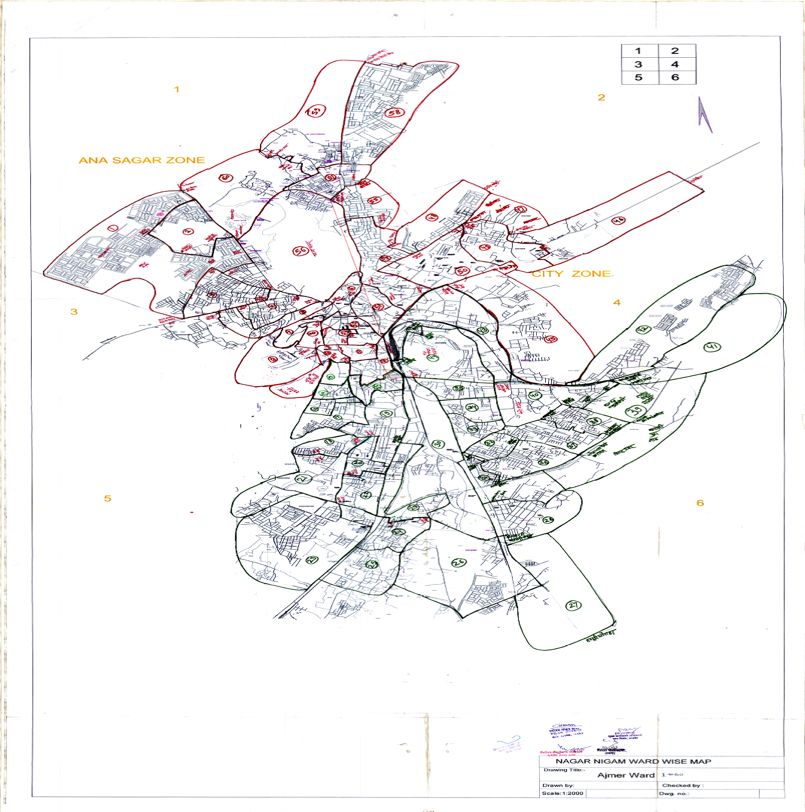
Participatory Research in Asia

                                          Table 2: No. of Wards in Ajmer City

                                 Year                               No. of wards
                                 2010 (second last election)        55
                                 2015 (last election)               60

       Ajmer Municipal Corporation (AMC) is one of the oldest local municipal body of Rajasthan
       established in the 1866. Ajmer Development Authority (ADA) was formed in 2013 dissolving the
       Urban Improvement Trust. At present, there are 60 wards in AMC and elections for Municipal
       Corporation were held in 2015.

                                     Figure 1: Latest Map of Ajmer Showing Wards

   3
Study Report
A General Poverty Profile of Ajmer City
Rajasthan State Slum Policy, 2012, defines slum as defined by Pronab Sen Committee Report i.e.
"a slum is a compact settlement of at least 20 households with a collection of poorly built
tenements, mostly of temporary nature, crowded together usually with inadequate sanitary and
drinking water facilities in unhygienic conditions".
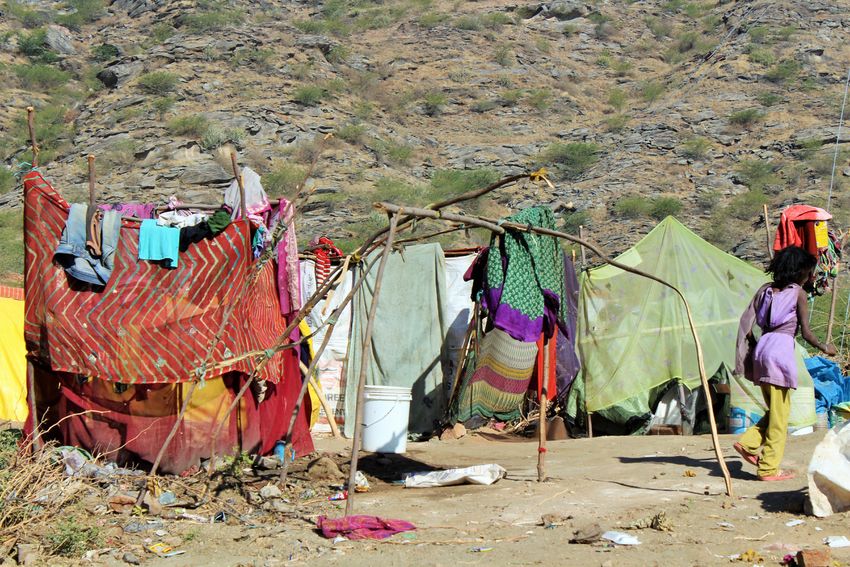
Ajmer city has 67 notified slums1 which are mostly located within the city centre. Some of the
informal settlements are more than 30 years old. The slums in outer areas of Ajmer are formed by
newly migrated settlers in the city. There are 43 non-notified informal settlements and 2 resettled
informal settlements in the city.
Along with proper Solid Waste Management, proper drainage facility is urgently required in the
city. During monsoons Ajmer city is often flooded without any proper outlets for water. The drains
are often clogged with solid waste which blocks the easy flow of sewage and waste water. Some
of the drains which play important role in drainage pattern of the city are: Bandi river, Kazi ka
nallah, Arihant colony drain, Anted chatri yojna drain, Vaishali diversion channel, Anasagar escape
channel, Brahmapuri drain, Anderkot madar gate drain. Indiscriminate discharge of solid waste
from the nearby areas into these drains regularly results in unhygienic environment, which gives
rise to many public health issues.
In previous effort, there has been in-situ development and construction in the informal settlements
under JNNURM. According to Government of Rajasthan (2006) report, for resettlement of Lohar
and Banjara communities, 2822 dwellings have been built. In our interactions with Lohar
communities, it was clear that many families were unwilling to move as this new colony was far
away from their present settlements. Hence many of these newly built dwellings were laying
vacant. The families have been living in the present settlements for a long time which also provide
livelihood options. Many people feared that they might lose their present livelihood options if they
moved to new dwellings.
1 Several socially derogatory terminologies are used for the slums or settlements of urban poor in government
records and policies (e.g., ‘Kacchi Basti’ in Rajasthan, ‘Malin Basti’ in Bihar and Uttar Pradesh, and ‘Jhuggi
Jhopari’/’Gandi Basti’ in many other states). This report has used ‘Informal Settlements’ instead of using the local
terminology for the dignity of the people living in such areas.
4Participatory Research in Asia
Methodology for Listing of Informal Settlements
The process of mapping informal settlements started with gathering secondary data from different
sources and studying the data for better understanding of the city. The secondary data included
list of notified slums with names of heads of households from Ajmer Municipal Corporation, 2011
Census Reports, latest map showing the wards, Master Plan and City Development Plan of Ajmer
and various other reports prepared under JNNURM.
It also involved a number of interactions with various stakeholders in the city. The stakeholders
included Ajmer Municipal Corporation officials and councillors, ex-councillors, ward development
committees, and community leaders of Lohar, Sansi, Banjara, and Harijan Communities. PRIA
team also interacted with organisations like Senior Citizen Council of Ajmer, media representatives
working on smart city and sanitation issues and different NGOs working in the city. These
stakeholder interactions and analysis of secondary data have helped us in understanding the city
and identifying and locating the notified, non-notified, and resettled slum locations in the city. The
consultation process also involved Rajiv Awas Yojana (RAY) officials who worked previously in the
city. The process of consultations helped the team in identifying citizen leaders and taking further
steps.
Right in the beginning, the elected councillor of a particular ward was informed about the purpose
of listing and mapping of informal settlements. The PRIA team members visited and interacted with
the ex-councillors as well as other contestants in the last civic election for seeking information
about the informal settlements and about the active citizens in the informal settlements.
The Anganwadi Centre in an informal settlement is engaged in a lot of activities. The team
consulted the Anganwadi workers which proved to be helpful in identifying the development issues
in informal settlement and the active women groups and youth in the community. A good
relationship with Anganwadi workers also enabled the team to interact candidly with the
community.
The existing community based organisations / associations, youth groups and religious groups
were identified and approached. Some of the community meeting places like shops, tea stalls,
gardens and community centres were also visited. These were the places where the community
people engaged in informal discussions which proved to be good sources of information. A visit to
these places gave a good idea about the community people and happenings in the community.
The team also facilitated a set of Participatory Urban Appraisal tools such as Transect Walk
through informal settlements, conducting Focus Group Discussions, Informal Interviews, Social
and Resource Mapping. During these interactions, the information was collected and verified from
the informal settlement residents.
The relevant information about each informal settlement was collected in a format which is
presented in Annex.1.
5Study Report
Status of Informal Settlements in Ajmer
The Ajmer Municipal Corporation (AMC) and the Ajmer Development Authority (ADA) are the two
institutions responsible for undertaking planning and implementation of development programmes
in Ajmer city. The AMC and ADA maintains a list of 67 identified informal settlements/informal
settlements (Annex.2) in the city where various services are being provided by the public
authorities. However, PRIA’s settlement mapping exercise identified a total of 116 informal
settlements (Annex.3), of which 59% (68) are notified and 41% (48) are non-notified informal
settlements.
Chart 1: Status of Informal Settlements in Ajmer
Non-notified, 41%
Notfied, 59%
Sixty percent (70) informal settlements in Ajmer are located on private lands followed by 32 percent
(37) which are located on the lands owned by one or the other departments of the state
government. Out of 37 informal settlements in this category, 10 informal settlements are located
on the lands owned by the Forest Department and 21 informal settlements are located on the lands
owned by either Urban Improvement Trust (UIT) or Ajmer Development Authority (ADA). Six
percent (7) informal settlements lands are owned by the Ajmer Municipal Corporation and two
percent lands are owned by the Railways.
Chart 2: Ownership of Informal Settlement Lands in Ajmer
Railway
2% Municipality
6%
State Government
32%
Private
60%
6Participatory Research in Asia
In Ajmer, eighty three (96) percent informal settlements are surrounded by the residential areas. Fifteen
percent (18) informal settlements are surrounded by commercial areas and two percent (2) are located
near industrial areas. There are six informal settlements (these have been counted under residential
category) which are surrounded by both residential and commercial areas.
Chart 3: Type of Area Surrounding the Informal Settlements in Ajmer
Commercial, 15% Industrial, 2%
Residential, 83%
Chart 4: Physical Locations of the Informal Settlements in Ajmer
50%
40%
40% 37%
30% 25%
18%
20%
8% 6%
10%
1% 3%
0% e
st
te
e
pe
ck
ed
es
ac
id
re
si
tra
di
/b
lo
ds
sp
Fo
p
bo
/s
nk
m
oa
ay
in
n
ba
du
er
rra
R
pe
ilw
at
er
O
e
te
ra
w
ag
riv
h/
illy
e
rb
th
lla
og
H
ga
g
na
Al
on
ill/
e
Al
f
id
nd
gs
La
on
Al
Forty percent (46) informal settlements are located in hilly terrain or slopes and thirty seven percent
(43) informal settlements are located alongside nallah or water bodies. Eighteen percent (21)
informal settlements are located in open spaces and 25 percent (29) informal settlements are
located along roadside. Since the physical locational categories are not mutually exclusive, for a
considerable number of informal settlements two to three locational categories are applicable. For
example, an informal settlement located alongside nallah is also located near roadside. Three
percent (3) informal settlements are located in landfill or garbage dumping site.
7Study Report
Chart 5: Locational Characteristics of Informal Settlements in Ajmer
60%
49%
50% 47%
40%
30%
20%
10%
3%
1%
0%
Near city centre In the periphery of city
Near/under high voltage power line Flood/water logging prone area
Chart 5 shows that 49 percent (54) informal settlements are located within the city centre and 47
percent informal settlements are located alongside the city boundary. The informal settlements
alongside the city boundary are relatively new. As new migrants are entering into the city, these
new informal settlements are being constructed alongside the boundary of city. These newly
formed settlements lack many basic services. Three percent informal settlements (4) are located in
areas prone to flooding and water logging. One informal settlement is located under high voltage
power line.
Chart 6: Type of Structures for Majority of Houses in Informal Settlements
Kutcha, 22%
Semi-pucca, 16% Pucca, 63%
In sixty three percent (73) informal settlements, majority of the houses are pucca and in 16 percent
(18) informal settlements, majority of the houses are semi-pucca. In 22 percent (25) informal
settlements, majority of the houses are kutcha. Over the years, there has been improvement in
these informal settlements and people have constructed pucca houses. Many of these informal
settlements are big in physical size and population.
8Participatory Research in Asia
Chart 7: Approach Road to Informal Settlements in Ajmer
Non-motorable
(Pucca), 7% Non-motorable
(Kutcah), 6%
Motorable (Kutcha),
12% Motorable (Pucca),
75%
Seventy five percent (87) informal settlements are approachable through motorable (pucca) roads,
whereas 12 percent informal settlements are approachable with motorable (kutcha) roads.
Chart 8: Type of Internal Roads in Informal Settlements of Ajmer
Kutcha, 41%
Pucca, 59%
In Ajmer, 59 percent (69) informal settlements have pucca internal roads, whereas in 41 percent
informal settlements (47) the internal roads are kutcha.
9Study Report
Chart 9: Distance of Informal Settlements from Nearest Motorable Roads
1-2 Kms, 5%
>2 Kms, 1%
>500 Mts-1 Km,
14%Participatory Research in Asia
Challenges and Lessons Learned
• PRIA team started interacting and knowing about the efforts of existing community leaders.
There were many doubts and questions among the community members. The team had to
take great efforts in answering all the questions and clarifying all the doubts. At the same time
the team had to make sure that no false promises are given to the community and be clear
about facilitation role in organising the communities.
• Most communities expected from PRIA as an NGO to provide some services or deliver the
government schemes. It took a long time for PRIA team to inform and educate the communities
about the project approach which intends to build capacities and organisations of the urban
poor.
• There were also negative perceptions about the work of NGOs and the accessibility to
government programmes and schemes. Many community members complained that in the
past, some NGOs have organised meetings, made plans, and gave commitments. However,
they never turned up, which resulted in a breach of trust between community members and
outsiders. Building trust with communities was important task before starting community
mobilisation.
• This initial phase of interaction has been followed by regular interactions with the community
leaders. These regular interactions and listening to the problems and concerns and answering
questions have been helpful for the team in establishing a good relationship with community
leaders and communities. One of the processes followed during this initial phase is inviting the
identified leaders to the PRIA office and showing around the office. During this visit, the team
gave lot of examples and success stories from other states. The continuous interactions on
the issues of informal settlement have been helpful in raising critical consciousness of both the
team and these leaders. Another issue that the team felt important was clearly communicating
that we were not from government department and there will not be any financial transactions
between the community and PRIA.
• The urban poor residing in these informal settlements were mostly wage earner and it was
difficult to organise any meeting or discussion. However, many community members were
comfortable and available for meetings on Sundays. The team rescheduled timings of
meetings according to the availability of the communities.
• Visiting the informal settlement on a regular basis and seeking help from these leaders for
information, taking transect walk through the informal settlement and analysing the problems
during these interactions. These efforts were made over a week before organising first meeting
with the community. In the first meeting, we made it a point to give an opportunity to these
leaders to address the gathering and validate the points or issues raised by these leaders.
These processes helped the team in successfully identifying and building a pool of community
leaders in each of settlement with whom we could work in the coming years.
• The process of Identifying and locating notified and non-notified informal settlements has been
a challenge as the city is expanding in all directions. The list of notified informal settlement has
11Study Report
not been reviewed and updated since a long time and hence some of the notified informal
settlements have been transformed into well built up areas since then.
• As the election to Ajmer Municipal Corporation took place in 2015, a lot of councillors were
new and lacked the full knowledge about communities and their development priorities.
• Most of the residents were unaware about the ownership of land on which informal settlements
existed. Many settlements were located on the lands owned by the Forest Department. In the
absence of required inter-departmental coordination, entitlement to lands by the informal
settlement dwellers has remained unresolved for a long time. It would require enabling laws
and policies.
• Many informal settlements were located on the hilly terrain and difficult to access in the
absence of proper road. This has also been one of the reasons why city authorities find it
difficult to provide certain services like piped water supply.
• Initially, it was also difficult to access and gather information from the Municipal Corporation
officials and elected councillors. However, with persistent efforts, the officials and councillors
got convinced about the project objectives and started cooperating.
References cited
Census of India (2011a). Retrieved from Census Commissioner of India.
Census. Census of India (2011b). Population Projections for States. Retrieved from Census
Commissioner
Governemnt of India (2015). Heritage City Development and Augmentation Yojana. Retrieved
from: http://hridayindia.in/wp-content/uploads/2015/01/hriday-brochure.pdf
Government of Rajasthan (2006). City Development Plan for Ajmer and Pushkar. Retrieved from:
http://jnnurm.nic.in/wp-content/uploads/2010/12/final_CDPAjmer-Pushkar.pdf
Government of Rajasthan (2002). Rajasthan Human Development Report 2002. Retrieved from
Government of Rajasthan: http://planningcommission.nic.in/popup/shdr/rajasthanhdr.pdf
Government of Rajasthan (2010). Water Supply and Sanitation. Rajasthan, India: Retrieved
from http://www.planning.rajasthan.gov.in/Annual plan_0910/pdf/chap_19.pdf
12Participatory Research in Asia
Annex.1
Format for Listing of Informal Settlements
Name:
Address/Location:
GPS location Latitude-
coordinates Longitude-
Date of taking GPS ---/----/----
location
Number of
Households in the
slum
Names of Mohallas in 1. 4.
the slum 2. 5.
(if applicable) 3. 6.
Municipal Ward(s) Name of ward: Ward Number:
Enter details of all
wards if slum is
stretched into more
than one ward)
Landmark
(for locating it on base
map)
Status of slum A- Notified
(tick one only) B- Non notified
C- Resettled
Land ownership status A- Railway G- Ownership Unknown
(tick one only) B- Airport Authority H- Any other, specify
C- Defense
D- Municipality
E- Private
F- State Government with name(s) of Department
Type of Area A- Residential
surrounding the slum B- Industrial
C- Commercial
D- Other slums
E- Other
Physical location of A- Alongside Nallah/ drain/ any other water body Characteristics of slum
the slum B- Along railway track A- Within city centre
C- River bank/ river bed B- Alongside boundary/fringe area of city
D- Hilly terrian/ slope C- In the vicinity/ under HTV power line
E- Open space/ park D- Flood prone area
F- Forest E- Water logging during rainy season
G- Along side land fill site/ garbage dump
H- Roadside (Tick as many as applicable)
Type of structure of A- Pucca
majority of houses in B- Semi Pucca
the slum C- Katcha
D- No structure
Approach road to slum A- Motorable (Pucca)
B- Motrable (Kutcha)
C- Non Motorable (Pucca)
D- Non Motorable (Kutcha)
Distance from A- less than 500 mts
motroable road B- 500 mts- 1 km
C- 1- 2 Kms
D- More than 2 Kms
Anganwadi centre A- Anganwadi Centre If Yes, Distance from Slum
(Yes /No) A- less than 500 mts
B- 500 mts- 1 km
C- 1- 2 Kms
D- More than 2 Kms
B- Primary school If Yes, Distance from Slum
(Yes /No) A- less than 500 mts
B- 500 mts- 1 km
School Facilities
C- 1- 2 Kms
D- More than 2 Kms
C- Middle school If Yes, Distance from Slum
13Study Report
(Yes /No) A- less than 500 mts
B- 500 mts- 1 km
C- 1- 2 Kms
D- More than 2 Kms
D- High school If Yes, Distance from Slum
(Yes /No) A- less than 500 mts
B- 500 mts- 1 km
C- 1- 2 Kms
D- More than 2 Kms
Health facilities E- Primary Health Centre If Yes, Distance from Slum
(Yes /No) A- less than 500 mts
B- 500 mts- 1 km
C- 1- 2 Kms
D- More than 2 Kms
F- Own toilet facilities at home A- Yes for all Households
B- For few Households only
C- Not available
G- Community toilet If Yes, Distance from Slum
Toilet Facilities
(Yes /No) A- less than 500 mts
B- 500 mts- 1 km
C- 1- 2 Kms
D- More than 2 Kms
Drinking water A- Piped Water Supply In case piped water tap is outside the
TapWater (Standpost) slum area. Distance from Slum:
(Yes /No) A- less than 500 mts
B- 500 mts- 1 km
C- 1- 2 Kms
D- More than 2 Kms
B- Handpump In case handpump is outside the slum
(Yes /No) area. Distance from Slum:
A- less than 500 mts
B- 500 mts- 1 km
C- 1- 2 Kms
D- More than 2 Kms
Drainage Drainage System If No, method used for waste water
(Yes /No) disposal
Garbage Collection Garbage collection If Yes, by whom
(Yes /No) A- Municipality
B- Private contractor
Frequency of garbage collection
A- Daily
B- Weekly
C- Every 15 days
D- No regularity
Whether the slum has A- Yes
benefitted from B- No
JnNURM/ RAY/any
other slum
improvement scheme?
Is there a presence of C- Yes
Slum dwellers D- No
association/
community based If yes, please specify-
group (s) in the slum Name of Group:
Name of leader:
(If more than one Contact details:
group provide details
of each group)
Contact details of Name: Name :
community members
Address: Address:
Contact number: Contact number:
14Participatory Research in Asia
Annex. 2
List of informal Settlements based on Secondary Sources
(Municipality/Development Authority/Census, etc.)
Sl. No. Old Ward No. Name of Informal settlement
1 1 Nausar
2 1 Berwa Basti Kotra
3 2 Mali Mohalla (Foy Sagar Road)
4 3 Sanjay Nagar (Boraj Road)
5 5 Shanti Nagar (Bagri Basti)
6 6 Trilok Nagar
7 7 Pahadganj
8 8 Labana Basti
9 8 Rambag
10 8 Sansi Basti (Bhagwan Ganj)
11 8 Sansi Basti (Pal Ke Paas Ambedkarnagar)
12 9 Ajay Nagar (Baadh Pidit)
13 10 Sadhu Basti
14 10 Kanjar Basti (Ramganj)
15 10 Gautam nagar
16 11 Rager Basti (Chandverdai Nagar)
17 12 Kohli Basti (Ramganj)
18 13 Khanpura Chisti
19 13 Subhash Nagar
20 15 Dhanka Basti (Asha ganj Road)
21 16 Ashaganj Harijan Basti (Idgah)
22 17 Masuda Nadi (Rawan Ki Bagichi)
23 23 Longiya Mohalla
24 24 Nagphani
25 24 Babugarh
26 24 Chamar Ghati (Rishi Ghati)
27 25 Lohar Basti (Kabootar Shala)
28 29 Dhanka Basti (Padav)
29 30 Berwa Basti Topdara
30 31 Banjar Basti (topdara)
31 32 Kamela Mohalla
32 32 Chadar Pal Bichla
33 33 Jadugar Basti
34 34 Barwari Pada (Jhalkari Nagar)
35 34 Gurjjar Dharti
36 34 Gurjjar Tila
37 34 Raberiya Mohalla
38 34 Pratapnagar Bhatta
39 35 Uttam Chand (Sunar Ka Bara)
40 35 Kumharon Ka Bara (Shankar Nagar)
41 35 Modiya Bheru (shivnagar)
15Study Report
42 35 Loon Karan Ka aahata
43 35 Ashok Nagar Bhatta
44 38 Parvatpura
45 39 Makhanpura
46 40 Balupura
47 41 Bhajan Ganj
48 42 Naag Bai (Harijan Basti)
49 42 Uday Ganj
50 45 Aam Ka Talaab (Kalyanipura)
51 45 Mishtri Mohalla (Gulab Bari)
52 46 Aam Ka Talaab (Kalyanipura)
53 47 Kalu Ki Dhani
54 48 Indra Colony (Meer Shah Ali)
55 48 Foos Ki Kothi
56 50 Police Line
57 50 Ghooghra Ghati
58 50 Jawahar Nagar
59 50 Hari Nagar
60 51 Loha Khan pili Khan
61 52 Om Nagar
62 52 Jatiya Hills
63 52 Ganesh Garh
64 53 Rajiv Colony LIC
65 53 Aanted
66 55 Cheeta Nagar (Chorsiawan)
67 55 Nosar Ghati
16Participatory Research in Asia
Annex.3
List of Informal Settlements Identified by the Mapping Exercise
Ward Sl. No. for
Name of the Informal Settlements Notified Non-Notified
No. Settlements
1 1 Chamunda mata Kotda Yes
1 2 Chamunda Mata slum Yes
1 3 Jhuggi Jopdi Patrakar Colony Kotda Yes
1 4 Lohar Basti Slum Yes
1 5 Nausar Ghati Yes
2 6 Bairwa Basti Yes
2 7 Banjara Basti Yes
3 8 Mali Mohalla, Ramnagar Yes
4 9 Mochi Mohalla Yes
4 10 Nagphani Choti (Laxmi Mohalla) Yes
4 11 Rager Basti Krishna colony Yes
5 12 Badi Nagphani Yes
5 13 Prince hill Yes
5 14 Sanjay Nagar Yes
6 15 Babugarh Yes
6 16 Banjara Basti Yes
6 17 Chamar Ghati Yes
6 18 Lohar Basti Yes
7 19 Lohar Basti Yes
7 20 Longiya Basti Yes
6,7 21 Kamela mohalla Yes
8 22 Silavat Mohalla, Noorani Masjid Yes
9 23 Amabawdi Yes
9 24 Bhatabaw Yes
9 25 Jaliyan Yes
12 26 Dhanka Basti Ashaganj Yes
12 27 Lohar Basti usri gate Yes
12 28 Masooda Nadi Rawan ki Bagichi Yes
14 29 Shantinagar Miyani Hospital ke piche Yes
15 30 Asha Ganj Harijan Basti Yes
15 31 Trilok Nagar Yes
16 32 Lohar Basti Yes
16 33 Pahadganj Yes
18 34 Bad Pidit Kachchi Basti Yes
18 35 Odh Basti Ajaynagar Yes
19 36 Labana Basti Yes
19 37 Rambagh Yes
19 38 Sansi Basti slum Yes
20 39 Gautam Nagar Yes
20 40 Koli basti Yes
20 41 Sadhu Basti Yes
21 42 Fakira Kheda Yes
21 43 Jagruti Nagar slum Yes
17Participatory Research in Asia
21 44 Lohar Basti Yes
21 45 Raiger Basti Chandra vardai Nagar Yes
22 46 Kanjar Basti Yes
24 47 Rajiv Nagar Yes
25 48 Chisti Nagar Yes
25 49 Kahar Basti Yes
25 50 Lohar Basti Yes
26 51 Parbatpura slum Yes
27 52 Makhupura Yes
28 53 Balupura slum Yes
29 54 Durga Colonny, Gaddi Maliyan Yes
30 55 Badiya Yes
30 56 Narsinghpura Yes
31 57 Shivaji nagar Yes
32 58 Bhajan Ganj Yes
32 59 Udai Ganj Yes
33 60 Ashok nagar bhatta Yes
33 61 Gurjar Teela Yes
33 62 Modiya Bheru Shiv Nagar Yes
33 63 Naun Karan Ka Hatha Yes
33 64 Shankar Nagar Yes
33 65 Uttam Chand Sonar Ka bada Yes
34 66 Gujar dharti Yes
34 67 Jhalkari Ngar Yes
34 68 Lohar Basti Yes
34 69 Pratapnagar Bhatta, near Mayo Link Road Yes
34 70 Rabadiya mohalla Yes
35 71 Jadugar Basti Yes
36 72 Chankya Chowk Yes
37 73 Nagbai harijan basti Yes
39 74 Bairwa Basti Yes
39 75 Harijan Basti Kalyanipura Yes
40 76 Mistri Mohalla Yes
41 77 Kalbeliya mohalla Yes
41 78 Sikhligar mohalla Yes
42 79 Bheel Basti Yes
42 80 Gurjar Basti Yes
42 81 Lohar basti Yes
42 82 Lohar Basti (Gulab Badi) Yes
43 83 Bairwa Basti Yes
43 84 Banjara Basti Yes
44 85 Churmuli Ka Bada Yes
45 86 Kalu Ki Dhani Yes
46 87 Aam ka talab Yes
46 88 Ghoogra Ghati Yes
46 89 Harijan basti Yes
47 90 Kundan Mohalla Yes
47 91 Lohakhan Pilikhan Yes
18Study Report
47 92 Phoos ki Koti Yes
48 93 Datanagar (Jatia Hills) Yes
48 94 Ganeshgarh Yes
48 95 Harinagar Yes
48 96 Om Nagar Yes
49 97 Nayak Basti Yes
50 98 Jawahar Nagar, Civil Line Yes
51 99 Rajendrapura slum Yes
52 100 Lohar basti Yes
54 101 Indira Nagar Yes
55 102 Aanter Colony Yes
55 103 Rajiv Colony Yes
56 104 Ambedkar Nagar Yes
57 105 Ramdev nagar Yes
57 106 UIT Colony Yes
58 107 Baldev Nagar Yes
58 108 Ganesh guwadi Yes
58 109 kayamkhani ki dhani Yes
58 110 Kayamkhani ki Dhani Yes
58 111 Lohar Mohalla, Global College Yes
58 112 Panchsheel Nagar Yes
59 113 Cheeta Nagar Yes
59 114 Eidgah colony Yes
60 115 Chourasiyawas Eidgah colony Ajmer Yes
60 116 Nausar Yes
19Participatory Research in Asia
Annex. 4
List of CBOs in Various Informal settlements of Ajmer
Name of the informal settlement Name of the CBO
Babugarh Shiv Mandir Samiti
Badi Nagphani Naghpani Vikas Samiti
Bairwa Basti Bairwa Navyuvak Mandal
Banjara Basti Brajeswar Mahadev Navyuvak Mandal
Chamar Ghati Yadav jatav Samaj Samiti
Datanagar (Jatia Hills) Datanagar Vikas Samiti
Gautam Nagar Gautam Nagar Sudhar samiti
Gurjar Teela Mahila Ganesh Samuha
Harinagar Harinagar Vikas Samiti
Kalu Ki Dhani Vishnu Hills Vikas Samiti
Kanjar Basti Kanjar Association
Lohar Basti Longiya Nav Yuvak Mandal
Lohar Basti Ghumantu Jaati Association
Lohar Basti Pradesh Ghumantu Gadia Lohar Vikas Samiti
Lohar Basti (Gulab Badi) Jila Gadia Luhar Samaj Sudhar Samiti
Longiya Basti Ghumantu evam Ardh Ghumantu Jaati Association
Makhupura Nav Yuvak Mandal, Ajmer
Mali Mohalla, Ramnagar Mahila Ayog Samita
Masooda Nadi Rawan ki Bagichi Valkimi Yuva vikas samiti
Naun Karan Ka Hatha Naun Karan Ka Hatha Vikas Samiti
Nausar Ghati Brajeswar Mahadev Navyuvak Mandal
Parbatpura informal settlement Rawat Seva Samiti
Prince hill Prince Hill Vikas Samiti
Rajendrapura slum Rajendrapura Shiv Sena Mandal
Sanjay Nagar Sanjay Nagar Vikas Samiti
Sansi Basti slum Sakal Sansi Samaj Panchyat Samiti
20Study Report
About PRIA
Established in 1982, PRIA (Participatory Research in Asia) is a global centre for participatory
research and training based in New Delhi, India. Currently, PRIA has field offices in several
states of India and partnerships with 3000 NGOs across the global North and South to deliver
its programmes on the ground. Over 36 years, PRIA has promoted ‘participation as
empowerment’, capacity building of community organisations, and people’s participation in
governance. Initiatives are undertaken in the overall perspective of ‘making democracy work
for all’ – in the political system; democratic culture in families, communities, and society; and
participatory democracy with active citizenship. PRIA’s programmes on the ground focus on
promotion of participation of the poor, especially women and youth, to claim rights and basic
services.
Through building knowledge, raising voice and making democracy work for all, PRIA realises
its vision – of a world based on values of equity, justice, freedom, peace and solidarity.
About Engaged Citizens, Responsive City
Engaged Citizens Responsive City is a four-year long intervention supported by the European
Union which focuses on strengthening civil society of the urban poor to participate in planning
and monitoring of sanitation services. The project works across three cities in India (Ajmer in
Rajasthan, Jhansi in Uttar Pradesh, and Muzaffarpur in Bihar). It primarily engages the urban
poor through capacity building activities to enable them to become active citizens, and to use
the new skills learnt to participate in planning (at city level) and monitoring (at the ward level)
of sanitation services. Partners in this change include urban poor and middle-class residents,
with leadership of young women and men; mayors, elected councillors and related government
departments; traders and market associations; civil society, academia and media; and women
sanitation workers.
To know more about the programme, please visit here.
ECRC project is funded by ECRC project is
the European Union implemented by PRIA
For more information contact
PRIA
42, Tughlakabad Institutional Area
New Delhi- 110062
Ph: +91-11-29960931/32/33
Connect with us:
www.pria.org | pria.india | PRIA_India
21You can also read