Alberta Transportation Springbank Off-stream Reservoir - Project Response to Part A IAAC Follow-up Questions - NET
←
→
Page content transcription
If your browser does not render page correctly, please read the page content below
Alberta Transportation
      Springbank
 Off-stream Reservoir
        Project

                               Response to
                                   Part A
                         IAAC Follow-up Questions

            April 2021
ALBERTA TRANSPORTATION SPRINGBANK OFF-STREAM RESERVOIR PROJECT
RESPONSE TO PART A IAAC FOLLOW-UP QUESTIONS
Table of Contents
PART A ....................................................................................................................................... 1
Question 1 ......................................................................................................................1
Question 2 ......................................................................................................................6
Question 3 ....................................................................................................................10
Question 4 ....................................................................................................................11
LIST OF FIGURES
Figure 1 Project Overview................................................................................................ 5
iALBERTA TRANSPORTATION SPRINGBANK OFF-STREAM RESERVOIR PROJECT RESPONSE TO PART A IAAC FOLLOW-UP QUESTIONS ii
ALBERTA TRANSPORTATION SPRINGBANK OFF-STREAM RESERVOIR PROJECT
RESPONSE TO PART A IAAC FOLLOW-UP QUESTIONS

PART A

Follow up on the suggested changes to the draft potential conditions as discussed by the
Decision Statement Team.

Question 1

A. BACKGROUND CONTEXT

   Potential conditions under the Canadian Environmental Assessment Act, 2012

   7.6   The Proponent shall decommission and plug off water wells located within the project
         development area that are not used to monitor groundwater quality pursuant to
         condition 7.9.1, prior to construction.

   Request: Alberta Transportation clarified that they may not be closing off all the water wells in
   the PDA prior to construction, but will be before the start of operations (with some caveats).
   IAAC may need more information on this position.

   Response

   Alberta Transportation’s recommendation (February 3, 2021): The Proponent shall
   decommission and plug off existing water wells located within the project development area
   that are not used for long term groundwater monitoring pursuant to condition 7.9.1, prior to
   flood operations.

   Alberta Transportation would like to retain some of the existing monitoring and/or domestic
   wells for potential monitoring during the baseline and construction phases of the Project,
   provided they are not at physical risk from construction activities. If existing wells are within
   the construction footprint, or are no longer of use for any further monitoring, they will be
   decommissioned as soon as practicable prior to construction in those areas.

   Some of the existing shallow Project groundwater monitoring wells completed in
   unconsolidated deposits will remain and become part of the long-term groundwater
   monitoring network for all phases of the Project. Because these shallow wells are completed
   in low hydraulic conductivity surficial materials overlying bedrock, the risk to groundwater
   quality resulting from flooding is considered low (i.e., they will not create a conduit to
   underlying bedrock aquifers). Should these wells be inundated during flood operations, they
   will be rehabilitated through flushing and re-development prior to being put back into
   service for monitoring.

                                                                                                       1
ALBERTA TRANSPORTATION SPRINGBANK OFF-STREAM RESERVOIR PROJECT
RESPONSE TO PART A IAAC FOLLOW-UP QUESTIONS
The Project groundwater monitoring wells and existing domestic wells that are installed in
bedrock and are in the wetted perimeter of the reservoir will be decommissioned prior to
Project operations (to allow for continued monitoring during the baseline and construction
phases). Prior to operations, these bedrock wells will be decommissioned to eliminate
potential pathways for groundwater quality impacts during flood operations.
B. BACKGROUND CONTEXT
Potential conditions under the Canadian Environmental Assessment Act, 2012
3.11 The Proponent shall conduct in-water project activities, including debris removal from
the water intake structures, outside of the Government of Alberta restricted activity
periods, unless otherwise agreed to by relevant authorities. If in-water project activities
cannot be conducted outside of the Government of Alberta restricted activity periods,
the Proponent shall develop and implement additional mitigation measures, in
consultation with Indigenous groups and Fisheries and Oceans Canada, to protect fish
during sensitive life stages.
Request: DFO has stated they want in-water activities to be limited to outside the RAP
only. IAAC recognizes that if something is safety-related, that may be a special case.
Response
If the Project is approved, Alberta Transportation will discuss the construction and
maintenance window requirements with Alberta Environment and Parks (AEP) fisheries
managers and will adhere to RAP requirements imposed by them. Should instances arise
where work may be required during the RAP, Alberta Transportation will work with federal
and provincial regulators and AEP fisheries managers to mitigate potential impacts, which
may include a relaxation from the published RAP. Instances where work may be required
during the RAP may include critical maintenance identified after spring break up that
requires actions prior to flood season or cofferdam failure due to overtopping during
construction.
C. BACKGROUND CONTEXT
Potential conditions under the Canadian Environmental Assessment Act, 2012
3.1.4 install riprap material on the diversion channel side slopes outside curves, on the water
face of the off-stream storage dam, and where the diversion channel enters the
reservoir to prevent future bank erosion;
Request: IAAC has requested Alberta Transportation to point them to a figure showing the
areas where riprap will be placed.
2ALBERTA TRANSPORTATION SPRINGBANK OFF-STREAM RESERVOIR PROJECT
RESPONSE TO PART A IAAC FOLLOW-UP QUESTIONS
Response
Alberta Transportation provided drawings for the diversion channel in the Preliminary Design
Report (PDR) (Preliminary Design Report [PDR], 2020, pages 279 to 282 available at:
https://www.nrcb.ca/download_document/2/83/10664/20201218-at-sir-to-nrcb-re-
preliminary-design-report). The locations of the riprap along the diversion channel are
illustrated in these drawings. The design of the diversion channel includes the installation of
riprap along the bottom of the diversion channel. To facilitate wildlife movement through the
PDA, the riprap in portions of the diversion channel will be infilled with smaller diameter
material, covered with topsoil, and seeded with grasses. In the EIA, it is assumed that the
riprap along approximately 2.5 km of the diversion channel length would be infilled, covered
with topsoil, and reseeded. The portions of the diversion channel which will require
excavation through rock, including at the upstream end and the downstream end of the
channel where exposed riprap is required for energy dissipation, cannot be infilled and
reseeded.
The Project design also includes a limited amount of riprap near the low-level outlet where
the approach channel meets the intake structure (PDR, 2020). The approach channel is
approximately 330 m long and will have a riprap lined bottom and for 1.5 vertical metres up
the side slopes, there is a five metre-wide bench on the right descending side of the channel
at the limit of the riprap, with channel slopes above the riprap not armored (PDR page 204
and 205; available at: available at:
https://www.nrcb.ca/download_document/2/83/10664/20201218-at-sir-to-nrcb-re-
preliminary-design-report). The low-level outlet exit channel and exit channel terminus will
also have some riprap. The exit channel is approximately 765 m long and will be riprap lined
on the bottom and for three vertical meters up the side slopes and the exit channel terminus
includes a proposed riprap lined scour pool (PDR page 205 and 206 available at:
https://www.nrcb.ca/download_document/2/83/10664/20201218-at-sir-to-nrcb-re-
preliminary-design-report).
REFERENCE
Stantec (Stantec Consulting Ltd.) 2020. Preliminary Design Report. Available at:
https://www.nrcb.ca/download_document/2/83/10664/20201218-at-sir-to-nrcb-re-
preliminary-design-report.
3ALBERTA TRANSPORTATION SPRINGBANK OFF-STREAM RESERVOIR PROJECT
RESPONSE TO PART A IAAC FOLLOW-UP QUESTIONS
D. BACKGROUND CONTEXT
Potential conditions under the Canadian Environmental Assessment Act, 2012
5.7 The Proponent shall direct any drainage pathway, constructed or modified as part of
the Designated Project, away from wetlands.
Request: We discussed the challenges of redirecting drainage channels away from the
diversion channel, and that water that enters the diversion channel will go to the reservoir
where there are wetlands. IAAC has requested if we can point them to a map of the
wetlands in the reservoir.
Response
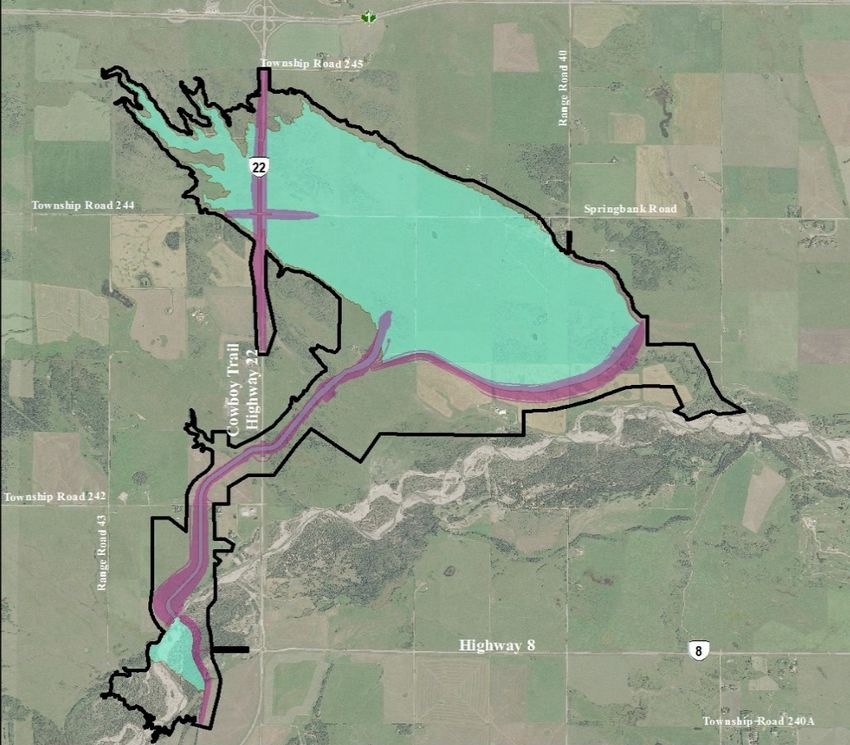
Alberta Transportation has mapped existing wetlands across the wetted area of the Project,
as shown in Figure 1 below. As illustrated, wetlands are present across much of the Project
area, and therefore, the request to direct flow away from the existing wetlands is not
practical at many locations. However, Alberta Transportation will direct flow away from
wetlands during construction, if practical, through reducing disturbance of the project
footprint, along with maintaining pre-construction drainage patterns where feasible using
culverts, bridges and naturally occurring low points. Alberta Transportation will implement
mitigation measures as provided in the draft vegetation and wetland mitigation, monitoring
and re-vegetation plan, and use sediment and erosion control and other best management
practices during the construction period.
41
Sp
-
rin
g ba nk Cree
NW-26-24-4-W5
Range Road 40
k
W1803(6.92ha)
NE-27-24-4-W5
W629(0.61ha)
W7(0.19ha) W1802(9.97ha)
SW-27-24-4-W5 SE-26-24-4-W5
W275 SE-27-24-4-W5 SW-26-24-4-W5
(3.20ha)
W1801
(1.35ha) Springbank Road
Township Road 244 W251(0.62ha) W284(0.78ha)
W250(0.08ha)
W252(0.09ha) NE-23-24-4-W5
NE-22-24-4-W5
Range Road 35
NW-23-24-4-W5
W699(1.80ha)
W688(0.96ha)
W578 SW-23-24-4-W5 SE-23-24-4-W5 W72
SW-19-24-3-W5
(0.06ha) (0.14ha)
SE-24-24-4-W5
W650 W189(1.39ha)
W43(0.11ha)
(0.14ha)
W42(0.51ha)
NE-14-24-4-W5 Range Road 41 W36(1.85ha)
W83(2.71ha) W64
W651(0.09ha) W54(0.68ha)
(1.54ha) W641(0.14ha)
NW-13-24-4-W5
NW-14-24-4-W5 W647 W38(0.06ha)
W108(0.83ha) (1.11ha) NE-13-24-4-W5
W721 W648 W1856 NW-18-24-3-W5
W39(0.06ha)
(0.08ha) (0.45ha) (0.04ha) W50 W47 W643(0.05ha)
(0.52ha)
Range Road 43
W646(41.60ha) (0.41ha)
W449 W65(0.09ha)
(0.51ha) W56(0.03ha)
W748(3.14ha)
Creek
W447(0.24ha) SW-14-24-4-W5
SE-14-24-4-W5 Pirmez
SW-13-24-4-W5
W657(0.23ha)
W655(0.58ha) ow River
Township Road 242 SE-15-24-4-W5 Elb
NW-10-24-4-W5
ROCKY VIEW
W346(0.25ha)
COUNTY
NE-10-24-4-W5
W413
22
(0.05ha)
|
ÿ
Wetland
SW-10-24-4-W5 |
ÿ
8
Study Area
Permanent Project Component
Borrow Source
Project Construction Area
M
ill
bu
rn
0 0.5
re 1 C 1.5 2
Circle 5 Estates
Source: Esri, DigitalGlobe,
kilometre
GeoEye,
ek Earthstar
ST-CAL-110773396-956 NAD 1983 3TM 114
Geographics, CNES/Airbus DS, USDA,
Sources: Base Data - ESRI, Natural Earth, Government of Alberta, Government of Canada
Thematic Data - ERBC, Government of Alberta, Stantec Ltd
Project Overview
ALBERTA TRANSPORTATION SPRINGBANK OFF-STREAM RESERVOIR PROJECT Figure 1ALBERTA TRANSPORTATION SPRINGBANK OFF-STREAM RESERVOIR PROJECT
RESPONSE TO PART A IAAC FOLLOW-UP QUESTIONS
Question 2
Request: Comments that indicate “results are not consistent with the findings of IR4-01”, in which
no suggested changes are provided, please provide suggested wording changes to ensure
consistency. This includes comments 2.2-27 (2), 2.3-29 (3), 7.1.1-72 (2), 7.2.1-82 (1 and 2), and
7.3.1-89 (1).
• 2.2-27 (2): At the maximum designed flood event (2013 design flood), the flooded
reservoir would cover an area of 730 hectares and the duration of diversion would be
3.75 days, with a residence time in the reservoir of 20 days and a release time of 38 days
to drain the reservoir.
Response
EIA, Volume 3B, Section 6, Table 6-4 shows the results of operational simulations for the
volumes in the reservoir that could be retained for the three floods of analysis, which
reflects the values stated in 2.2-27(2). However, in IAAC Round 2 IR4-01, Alberta
Transportation was asked to explore the possibility of releasing water from the reservoir
earlier, relative to the release timing described in the EIA. Revised modelling was
completed to factor in early and late release scenarios based on Elbow River flows (i.e.,
early reservoir release when Elbow River recedes to 160 m3/s and late release when
Elbow river recedes to 20 m3/s. Based on the revised modelling, the predicted early and
late release scenarios are as follows.
Alberta Transportation would suggest modifying the report language in 2.2-27 (2) as follows (red
text indicates corrected language):
At the maximum designed flood event (2013 design flood) the flooded reservoir would
cover an area of 766.5 hectares. Depending on early or late release of flood waters from
the reservoir, the duration of diversion would be 3.8 days, with a maximum residence
time in the reservoir of zero to 21 days and a release time between 35.4 to 36.7 days to
drain the reservoir.
• 2.3-29 (4): Flood operations would occur when flows in the Elbow River meet or exceed
160 cubic metres per second. The auxiliary service spillway gates would be raised to
create a backwater upstream of the diversion structure, and the diversion inlet gates
would be lowered to allow flows through the diversion channel for storage in the off-
stream reservoir. Once the off-stream reservoir has been filled, the diversion inlet gates
would be closed and the auxiliary service spillway gates lowered. The diverted
floodwaters would be retained in the off-stream reservoir until the flood event has
subsided.
6ALBERTA TRANSPORTATION SPRINGBANK OFF-STREAM RESERVOIR PROJECT
RESPONSE TO PART A IAAC FOLLOW-UP QUESTIONS
• Once the flood event has ended, post-flood operations would involve opening the outlet
structure gates to allow the waters retained in the off-stream reservoir to re-enter the
Elbow River. The operational rule for releasing water is when flows drop below 160 cubic
metres per second in the Elbow River, which is the earliest release scenario. Conversely,
the latest release scenario is releasing the water based on keeping flows in Elbow River at
or below bankfull flow rates (47 cubic metres per second). The estimated days from start
of diversion to complete reservoir drawdown of the 2013 design flood (worst case
scenario) for early release and late release times are proposed to be 39.2 days and 61.5
days, respectively. Other post-flood operations include maintenance activities, as
required, of the diversion system, diversion channel, debris deflector, off-stream reservoir,
off-stream dam embankment, low level outlet, and roads and bridge. Post-flood
maintenance activities would include removal of sediment and debris, confirmation of
functionality, repair, internal drainage and regrading, revegetation and inspections.
Response
Alberta Transportation has undertaken revised modelling to assess early and late release
scenarios, in order to factor in the range of operation scenarios. The early release
scenario is an operational rule for releasing flood waters from the reservoir earlier, at a
time when the flows in Elbow River are below 160 m3/s (following the peak of flood flow in
Elbow River). Alberta Transportation has provided the suggested revision for the condition
below.
Alberta Transportation would suggest modifying the report language in 2.3-29 (4) as follows (red
text indicates corrected language):
Flood operations would occur when flows in the Elbow River meet or exceed 160 m3/s
per second. The service spillway gates would be raised to create a backwater upstream
of the diversion structure, and the diversion inlet gates would be raised to allow flows
through the diversion channel for storage in the off-stream reservoir. Once the off-stream
reservoir has been filled, the diversion inlet gates would be closed and the auxiliary
service spillway gates lowered. The diverted floodwaters would be retained in the off-
stream reservoir until the flood event has subsided.
Once the flood event has ended, post-flood operations would involve opening the outlet
structure gates to allow the waters retained in the off-stream reservoir to re-enter Elbow
River. The operational rule for releasing water is when flows drop below 160 m3/s in Elbow
River. The response to Round 2 IAAC information request (IR) 4-01 assessed an early and
late release scenario to cover the likely range of operational scenarios. The early release
scenario is the operational rule and has the reservoir release when flows in the Elbow
River drop below 160 m3/s. Late release has the reservoir discharging when flows in Elbow
River are below 20 m3/s. The estimated days from start of diversion to complete reservoir
drawdown of the 2013 design flood for early release and late release times were 39.2
days and 61.5 days, respectively. Other post-flood operations include maintenance
7ALBERTA TRANSPORTATION SPRINGBANK OFF-STREAM RESERVOIR PROJECT
RESPONSE TO PART A IAAC FOLLOW-UP QUESTIONS
activities, as required, of the diversion system, diversion channel, debris deflector, off-
stream reservoir, off-stream dam embankment, low level outlet, and roads and bridge.
Post-flood maintenance activities would include removal of sediment and debris,
confirmation of functionality, repair, internal drainage and regrading, revegetation and
inspections.
• 7.1.1-72 (2): Also, changes in water temperature due to water released from the reservoir
would result in direct mortality as well as cause a variety of sub-lethal or stress related
effects on fish, specifically, incubating eggs and spawning adults as these are more
susceptible to temperature changes. Flooding of upland areas could lead to increased
nutrient concentrations which could lead to eutrophication and have undesirable effects
on fish health.
Response
Different water quality parameters and their associated effects on fish and fish habitat
respond in different ways depending on the flood and timing of release.
Alberta Transportation would suggest modifying the report language in 7.1.1-72 (2) as follows
(red text indicates corrected language):
Also, changes in water temperature due to water released from the reservoir could result
in direct mortality as well as cause a variety of sub-lethal or stress related effects on fish,
specifically, incubating eggs and spawning adults as these are more susceptible to
temperature changes. Flooding of upland areas could lead to increased nutrient
concentrations which could lead to eutrophication and have undesirable effects on fish
health. Effects monitoring (i.e., monitoring for changes to water quality) will be used to
determine if Project related changes occur in Elbow River. In addition, potential effects
on fish will be mitigated through fish health monitoring and a fish rescue plan.
• 7.2.1-82 (1 and 2): 3.7 percent of the LAA (192.6 hectares of the reservoir); 0.8 percent
(37.4 hectares of the reservoir); 3.0 percent of the LAA (145 hectares of the reservoir)
Maximum sediment depth would be approximately 3.4 m and would occur close to the
low level outlet, in the deepest portion of the reservoir.
Response
Response and corrected the report language in 7.2.1-82 (1) and 7.2.1-82 (2):
Revised sediment depths from the early and late release modelling are presented in the
response to Round 2 IAAC IR4-01b. Modelling results of the updated Mike 21 FM - MT
(mud transport) module indicate sediment will be deposited over most of the reservoir for
early release and late release during the design flood. Deposition patterns, including
sediment extent and depths, are similar for both releases, with the greatest difference
8ALBERTA TRANSPORTATION SPRINGBANK OFF-STREAM RESERVOIR PROJECT
RESPONSE TO PART A IAAC FOLLOW-UP QUESTIONS
being the extent of sediment in the less than 3 cm depth category: 318 ha early release
(39% of baseline area in the reservoir) and 269 ha late release (33% of baseline area in
the reservoir). Most of the sediment deposition is expected to range from 10 cm to
100 cm deep in the reservoir (319 ha, 39% for early release; 337 ha, 41% for late release).
Sediment ranging from 3 cm to 10 cm deep will cover 124 ha (15% of baseline area in
the reservoir) to 155 ha (19% of baseline area in the reservoir) of the reservoir for early
release and late release, respectively. Sediment greater than 100 cm deep will cover
5.1 ha (0.6% of baseline area in the reservoir) to 5.6 ha (0.7% of baseline area in the
reservoir).
Note, a maximum sediment depth was not recalculated for the updated early and late
release sediment modelling, but the aerial extent of sediment greater than 100 cm
decreased from 41 ha in the EIA to just over 5 ha for both the early and late release
scenarios.
• 7.3.1-89 (1): Proponent predicts flood duration to extend through summer for up to 84
days (up to 45 days to operate and 39 days to drain the reservoir.
Response
The 84 day prediction reflects the 1:100 year flood, where flood could be inundated for
up to 84 days (as stated in the EIA, Volume 3B Section 7 and Round 1 AEP IR330). Based
on the updated modelling, the late release scenario for the 1:100 year flood predicts up
to 92. 3 days from start of diversion to complete reservoir drawdown, and 61.5 days for
the design flood (2013 flood). (Round 2 IAAC IR4-01).
Alberta Transportation would suggest modifying the report language in 7.3.1-89 (1) as follows
(red text indicates corrected language):
Proponent predicts flood duration for the design flood (2013 flood) to extend through
summer for up to 61.5 days (up to 24.8 days to operate and 36.7 days to drain the
reservoir).
9ALBERTA TRANSPORTATION SPRINGBANK OFF-STREAM RESERVOIR PROJECT RESPONSE TO PART A IAAC FOLLOW-UP QUESTIONS Question 3 Request: With regards to the monitoring requirements for air quality, provide suggested changes to ensure monitoring is feasible (6.1.2 – 48(4)) Response Alberta Transportation has committed to construction and post-flood air quality monitoring which will allow Alberta Transportation to assess air quality changes under construction and post- flood operation phases. Should ambient air quality exceedances be detected, Alberta Transportation will implement appropriate mitigation measures and adaptive management to address the issue. These measures could include: application of tackifier, watering, additional cover crops or seeding on areas of dust sources and sediment to encourage vegetation growth; and the implementation of physical screens or shelter belts. If concerns about air quality are raised by residents of the project area, these can be communicated to the Community Liaison for investigation and follow-up. In the event there are any exceedances of air quality objectives, Alberta Transportation will investigate the cause of those exceedances and if they are deemed to be associated with project construction activities, will undertake appropriate mitigation actions. Alberta Transportation will conduct ambient monitoring after a flood event to monitor potential effects associated with windblown sediment. During the NRCB Hearing, Alberta Transportation committed to continuous PM2.5 construction monitoring at Calaway Park, when open and monitoring for total suspended particulate (TSP) and PM2.5 at a location near the east PDA boundary will be conducted for 16 months after a flood event (i.e., from the flood event to the end of the fall season in the following year) to facilitate the timely application of additional mitigation measures for fugitive dust, if required (Undertakings 49 and 55 available at: https://www.nrcb.ca/download_document/2/83/11113/407-at-sub-to-nrcb-hearing-34-44-46-47- 48-49-50-51-52-53-55-and-56-59). 10
ALBERTA TRANSPORTATION SPRINGBANK OFF-STREAM RESERVOIR PROJECT
RESPONSE TO PART A IAAC FOLLOW-UP QUESTIONS

Question 4

Request: Provide an update on offsetting plans, status, and ongoing discussions.

Response

Alberta Transportation is in discussion with the Department of Fisheries and Oceans (DFO)
regarding the forthcoming Application for Authorization under Sections 34.4 and 35.1 of the
Fisheries Act and Section 73 of the Species at Risk Act. Preliminary estimates of harmful alteration,
disruption, and destruction (HADD) and Death of Fish were submitted to DFO on October 25,
2020 and feedback was requested to inform offsetting selection. Feedback on the estimates
was received from DFO on March 3, 2021. In addition, Alberta Transportation has presented
seven (7) conceptual offsetting options to DFO for initial comment, and assisted DFO in their
consultation efforts with Alberta Environment and Parks (AEP) on August 6, 2020, and Indigenous
groups on November 26, 2020 and January 26, 2021. Discussions with DFO are on-going.

                                                                                                 11
ALBERTA TRANSPORTATION SPRINGBANK OFF-STREAM RESERVOIR PROJECT RESPONSE TO PART A IAAC FOLLOW-UP QUESTIONS 12
You can also read