"All that glitters " The Scientific and Financial Ambitions of Robert Bell at the Geological Survey of Canada - Érudit
←
→
Page content transcription
If your browser does not render page correctly, please read the page content below
Document generated on 11/04/2021 11:03 a.m.

Geoscience Canada
Journal of the Geological Association of Canada
Journal de l’Association Géologique du Canada

"All that glitters…"
The Scientific and Financial Ambitions of Robert Bell at the
Geological Survey of Canada
Ian A. Brookes

Volume 43, Number 2, 2016                                                              Article abstract
                                                                                       In Canada, the 19th-century development of sciences with a geographical
URI: https://id.erudit.org/iderudit/1036781ar                                          component was marked by individuals whose contributions were remarkable
                                                                                       for their details, their geographical coverage, the originality and longevity of
See table of contents                                                                  their ideas. Collectively, these individuals could be called the ‘inventors of
                                                                                       Canada.’ Among them was Robert Bell. Early in his career at the Geological
                                                                                       Survey of Canada and during an interval of part-time service while he taught at
Publisher(s)                                                                           Queen’s University (1864–68), Kingston, Ontario, Robert Bell (1841–1917)
                                                                                       involved himself in several commercial schemes that he hoped would lead to
The Geological Association of Canada                                                   the development of mineral occurrences in the British colony of Newfoundland
                                                                                       (various minerals), Canada East and West (petroleum), and Nova Scotia (gold),
ISSN                                                                                   developments that he hoped would also raise his financial as well as his
                                                                                       scientific stature. Here, the circumstances of these ventures and their outcomes
0315-0941 (print)                                                                      and his unencumbered achievements in later life are reviewed.
1911-4850 (digital)

Explore this journal

Cite this article
Brookes, I. A. (2016). "All that glitters…": The Scientific and Financial Ambitions
of Robert Bell at the Geological Survey of Canada. Geoscience Canada, 43(2),
147–158.

All Rights Reserved © The Geological Association of Canada, 2016                      This document is protected by copyright law. Use of the services of Érudit
                                                                                      (including reproduction) is subject to its terms and conditions, which can be
                                                                                      viewed online.
                                                                                      https://apropos.erudit.org/en/users/policy-on-use/

                                                                                      This article is disseminated and preserved by Érudit.
                                                                                      Érudit is a non-profit inter-university consortium of the Université de Montréal,
                                                                                      Université Laval, and the Université du Québec à Montréal. Its mission is to
                                                                                      promote and disseminate research.
                                                                                      https://www.erudit.org/en/
GEOSCIENCE CANADA Volume 43 2016 147
ARTICLE
he hoped would also raise his financial as well as his scientific
stature. Here, the circumstances of these ventures and their
outcomes and his unencumbered achievements in later life are
reviewed.
RÉSUMÉ
Au Canada, au 19e siècle, le développement des sciences com-
prenant un volet géographique a été marqué par des individus
dont les contributions ont été remarquables par leurs détails,
leur couverture géographique, leur originalité, et la longévité de
leurs idées. Collectivement, ces personnes pourraient être
appelées les «inventeurs du Canada». Parmi elles se trouvait
Robert Bell. Tout au début de sa carrière à la Commission
Géologique du Canada, et pendant son service à temps partiel
alors qu’il enseignait à l’université Queen’s à Kingston, Ontario
(1864–1868), Robert Bell (1841–1917) s’est impliqué person-
“ALL THAT GLITTERS…:” The Scientific and nellement dans plusieurs programmes commerciaux qu’il
espérait mener au développement des richesses minérales de la
Financial Ambitions of Robert Bell at the colonie britannique de Terre-Neuve (divers minéraux), du
Geological Survey of Canada Canada-Est et Canada-Ouest (pétrole), et de la Nouvelle-
Ecosse (or). Il espérait que ces développements aug-
Brookes, Ian A.+ menteraient son statut financier ainsi que scientifique. Dans cet
article, la situation de ces entreprises et leurs résultats, et ses
Geography Department accomplissements scientifiques indépendants, sont passés en
York University, Toronto, Ontario revue.
M3J 1P3, Canada Traduit par le Traducteur
+
Ian Brookes, passed away February 13th, 2015, and is missed
by the Canadian Geoscience Community. This paper was sub- INTRODUCTION
mitted, reviewed and revised prior to his passing, and was Objective
finalized for publication by the generous efforts of his col- Robert Bell’s 50-year career with the Geological Survey of
leagues Ian Spooner and Antony R. Berger. Canada (GSC) left him with a dual reputation in the history of
Canadian Geology; on the one hand, as the farthest-travelled
SUMMARY explorer of Canada of his times and author of a landmark syn-
In Canada, the 19th-century development of sciences with a thesis: On Glacial Phenomena in Canada (Bell 1890); on the
geographical component was marked by individuals whose other hand, as a fractious schemer against Director William
contributions were remarkable for their details, their geograph- Logan’s successors, Alfred Selwyn and George Dawson, and
ical coverage, the originality and longevity of their ideas. Col- knowing seeker of financial gain in ventures stemming from
lectively, these individuals could be called the ‘inventors of his and others’ geological investigations. The paper examines
Canada.’ Among them was Robert Bell. Early in his career at this duality.
the Geological Survey of Canada and during an interval of
part-time service while he taught at Queen’s University (1864– Young Bell at the Geological Survey of Canada
68), Kingston, Ontario, Robert Bell (1841–1917) involved him- In 1857, shortly before his 16th birthday, Robert Bell (1841–
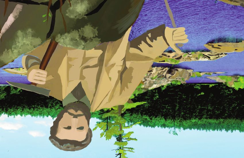
self in several commercial schemes that he hoped would lead 1917; Fig. 1) was recruited into the Geological Survey of
to the development of mineral occurrences in the British Canada (GSC) by its Director, Sir William Logan (1798–1875),
colony of Newfoundland (various minerals), Canada East and following the early death of his father, Andrew, a Presbyterian
West (petroleum), and Nova Scotia (gold), developments that minister and noted amateur geologist. Bell met with early
Geoscience Canada, v. 43, http://www.dx.doi.org/10.12789/geocanj.2016.43.098 pages 147–158 © 2016 GAC/AGC®148 Brookes, Ian A.
pared to summarize the Survey’s first 20 years’ work (Logan et
al. 1863). The volume was published just as Bell took up a five-
year professorship at Queen’s University at Kingston (1864–
68; Brookes 2011), establishing him then as one of the few
authoritative Canadian adherents to ‘Glacierism.’
Seeking Status
I posit several influences on Bell’s early-career pursuit of
financial as well as scientific status. First, his concern for the
reputation of the GSC as an engine of Canada’s economic
development, which lay at the root of its establishment in
1842, the year following the constitution at Westminster of the
Province of Canada from the former ‘Upper’ and ‘Lower’
Canadas. The Industrial Revolution had by then been in
progress for two generations; the United States was expanding
rapidly on its rich (and richly surveyed) resource endowment
(e.g. Pennsylvania coal and Superior iron ore). North of the
border the search for the Carboniferous system above the
Devonian rocks had drawn blanks, while iron ore in the crys-
talline ‘Azoic’ (Precambrian) rocks occurred only as small bod-
ies of sulfide, which could not be smelted at large enough scale
until the Bessemer process arrived in North America in the
1860s.
On Manitoulin Island, in Georgian Bay of Lake Huron
(Fig. 2), Logan’s lieutenant, Alexander Murray (1810–1884),
recognized the association of petroliferous seeps with low-
amplitude anticlines in the Paleozoic limestone–shale sequence
(Murray 1847), while Logan (1846) reported seeps in the
Gaspé Peninsula (Fig. 2); both occurrences attracted capitalists.
Capitalism was – had to be – to the fore at all levels of society
at this time, especially concerning mineral resources, although
Figure 1. Robert Bell, Montreal, QC, 1865. McCord Museum, McGill University, the American Civil War was depressing the economy north of
Notman Collection, catalogue no. I-17981.1 the border. Although most noted for his glacial and forest
studies, economic minerals and mining were never very far
approval at the Survey, then based in Montréal. Although his down on Murray’s ‘to-do’ list – field and office.
duties were those of assistant to field parties, he published Second, with the fortunes accruing during the California
eight articles in his first four years on Natural History materials Gold Rush of 1849, and the Silver Boom a decade later, Cana-
collected on his first two explorations (Bell 1858, 1859a, b, da-to-be experienced its own ‘rushes’ – placer gold in the Fras-
1861a, b, c, d, e). er Valley in 1858, in the Cariboo District in 1861, in the colony
Such was that early approval that in 1858, with Logan’s of British Columbia, and, more hesitantly, after 1858 discover-
encouragement, Bell enrolled part-time at McGill University, ies, vein gold in Nova Scotia. During his years at Queen’s Uni-
where, for a year, there being no Geology program, he studied versity, again as private not public servant, Bell found himself
for the certificate in Civil Engineering. At the same time, and conveniently placed to involve himself in Scotian gold.
for the following two years, he attended lectures in Geology Third, while again as private citizen, Bell sought financial
given by McGill’s recently appointed Principal, J. William Daw- gain from mineral developments in Newfoundland. Relations
son (1820–1899). He graduated in Civil Engineering in 1861, between the Province of Canada and Britian’s oldest colony
with as much Geology as an established degree program would became close geologically when, in response to a British
then have been able to offer, but no degree. request in 1864, Logan seconded Alexander Murray to head a
Prior to his studies, Bell would have known of Logan’s geological survey of the Island. Formal institutional heft
embrace of the Glacier Theory (first announced officially in behind discovery of mineral resources in Newfoundland, in
Logan 1847), while Principal Dawson was a life-long adherent Logan’s mind to Canada’s advantage, was seen as an entice-
to the Drift Theory (e.g. Dawson 1866). Admiration of Logan ment to Newfoundland’s joining the Canadian confederation
was general amongst Survey staff, including young Bell, for being formulated that year in conferences at Charlottetown
more than scientific reasons, which may have influenced him and Québec.
to follow Logan’s glacier leanings on his field explorations. With these institutional encouragements, identification of
After Bell’s first three years as assistant, Logan was confident personal influences on Bell’s monetary pursuits must necessar-
enough in him that he assigned him solo fieldwork. As well, in ily be loaded with subjectivity. Nevertheless, three such influ-
1862, burdened with administration, fundraising, and interna- ences are posited here.
tional exhibitions, Logan assigned Bell the task of writing a First, Bell’s upbringing was in no way moneyed; his father
section on ‘Superficial Deposits’ for the volume being pre- was a poorly paid, intellectual cleric who was married asGEOSCIENCE CANADA Volume 43 2016 149
50º
a 80º 75º 70º 65º 60
60º 55º
ke
La igan PQ
ch
Mi
MI
Ottawa R.
Lake Huro
u n Saguenay R. 50º
BP Gaspé Pen
Q Gulf of
ON St. Lawrrence NL
Lambton M R .
County O re nce
T L aw NB IdlM
85º Lake St.
SJR PEI
Ontario StJ
S
Lake Eriie SJ
40 nd y NS
N
f Fu
R.
º
y o
USA Ba
on
H ATLANTIC
ds
OCEAN 45º
Hu
0 100 200 300 km
80º 40º 75º 70º
70 65º 60º 55º
b c C
d
Gulf of 0 25 50 km BB
Lake Huron St. Lawrence
N
Cr
N
G
BI
S
Gulf of
St. Lawrence Cu
Pt Mr
Ek ATLANTIC
OS OCEAN As
D H PaPP Pb
N
0 5 10 km St GB
H
0 25 50 75 km
Coal
C Gy
Figure 2. (a) Eastern Canada, showing (red outline) locations of mineral occurrences in which Robert Bell was involved. Cities mentioned in text: T (Toronto), O (Ottawa),
M (Montréal), Q (Québec), H (Halifax), SJ (Saint John), St.J (St. John’s), IdlM (Iles de la Madeleine), MI (Manitoulin Island), SJR (Saint John River). (b) Historical oil-producing
region of Canada West: S (Sarnia), Lambton County (dashed boundary); Ek (Enniskillen Township), D (Dawn Township), Pt (Petrolia), OS (Oil Springs). (c) 1860’s gold mining
in Nova Scotia (hammer symbols), H (Halifax), C (Canso); county boundaries: H (Halifax County), G (Guysborough County). (d) Southwest Newfoundland, places visited by
Richardson’s Geological Survey of Canada party, 1867: C (Codroy), St GB (St. George’s Bay), BI (Bay of Islands), BB (Bonne Bay), PaPP (Port au Port Peninsula); mineral
occurrences (hammer symbol): Gy (gypsum), Coal, Pb (lead sulfide), As (chrysotile asbestos), Cu (York Harbour copper sulfide), Mr (Humbermouth marble), Cr (Bonne Bay
chromite).
strongly to his Natural History pastimes as to his ministry. He Bell practiced his Presbyterianism as professional pursuits
instilled Presbyterian as well as scientific values in Robert and allowed; for example, in scores of letters home from his explo-
his younger brother, John. His mother was a lawyer’s daughter, rations there is no mention anywhere of religious observances
who must originally have seen in her suitor both moral and by him, or exhortations to the family. At home for the ‘office’
intellectual, rather than financial, comfort – a functional part- part of the year he regularly attended St. Andrew’s church with
nership at least, curtailed prematurely after 18 years by the family, and was thought of highly enough there to have a
Andrew’s death from one of the common and incurable wall-plaque dedicated to his memory. Then, while Darwin’s
bronchial infections then so prevalent. Natural History, there- ‘The Origin of Species’ first appeared (1859) during his McGill
fore, was to be Bell’s intellectual and (small ‘r’) religious path. studies, and was one of his graduation prizes, its thesis was150 Brookes, Ian A.
never evident in Bell’s writings. He taught at Queen’s Universi- and no Survey report of it was issued. Aside from banker
ty from 1864–689 (Brookes 2011); in a ‘Prologue’ written for Ross’ commercial interests, the expedition could be seen as a
his Natural History course at Queen’s he clearly saw ‘Creation’ ‘private’ part of Canada’s enticement of Newfoundland to join
as ‘Divine,’ but, nevertheless, ‘Nature’ revealed herself to ‘Sci- the Confederation, which was enacted that year. As for Bell’s
ence.’ participation, Logan probably also saw it as good experience
Second, his first years at the Survey (the late 1850s), he for him.
received (irregularly) the equivalent of about $2.00 a day from With logistics arranged, they sailed from Gaspé, Québec,
Logan’s pocket it seems, which was enough only to feed him. southeast to Iles de la Madeleine, in mid-Gulf of St. Lawrence
Robert, therefore, must early have sensed that maintenance of (Fig. 2a), but nothing survives of investigations there. From
both social and financial status was going to depend on there, the southwestern tip of Newfoundland was due east.
belonging to the upper middle-class, and that this had implica- Near Cape Anguille, Newfoundland, the southwest extremity
tions to income. Brother John obtained the Medical Doctorate of the island, on June 15 they checked on Jukes’ report of a
degree from McGill at age 21, and thus was not going to suffer cliff exposure of gypsum near Codroy, a French fishing station
financially, although he early showed an humane concern for near the southwest limit of the ‘French Shore’ (Rowe 1980;
patients from the working poor of Montréal. John died in Hillier 1996). Murray, then in his third year of Newfoundland
1878, aged 33, of a bronchial affliction, but likely remained to Survey, had also visited it (Murray 1866, in Murray and Howley
Robert an example of secure social status. In that year (1878) 1881). Jukes had referred to ‘vast masses’ of gypsum, but the
Robert himself was awarded the MD from McGill, which is outcrop in the sea-cliff is only about 100 metres wide, and, if
seen by most as his response to sicknesses among Native peo- its associated karstic dolines define its inland extent, this
ples, whom he respected as guides, canoe men, and victuallers amounts only to ~100 m. Besides acting as a soil conditioner
of his Survey explorations. for the alkaline soils of Canada West, where gypsum was
Third, in 1864, at 23, Robert visited a Glasgow family, to already plentiful, the small size of the Newfoundland occur-
the matriarch of which his mother, a Notman, was distantly rence meant that its economic value was not then great, nor
related. The Smith family, with 14 children, was headed by the would it ever be (although Murray later discovered a huge gyp-
successful owner of an engineering company with local and sum body further north, inland of St. George’s Bay, New-
Caribbean customers, particularly for railway rolling stock, foundland, which was worked until 2007 for wallboard manu-
rails, and bridges. Nine years later (1873) Bell married into this facture at Corner Brook).
family, approaching 32 – 13 years the senior of his spouse, To the north, 2 miles inland of the St. George’s Bay shore,
Agnes – and would have wished to keep her in the comfort in Jukes had recorded two seams of coal in the banks of Middle
which she was raised. This took some time; for instance, it was Barachois and Robinsons rivers (Fig. 2d), which had been
20 years before home ownership replaced rental, six years known from Captain Cook’s surveys, exactly a century before
before a child arrived, a second more than two years later, the Richardson party’s visit. Of the 12 seams eventually known
eventually growing to four. The Bells employed live-in girls as (Howley 1896), Richardson’s party sampled two 2-foot seams,
domestic help or for childcare. Even then, on his superannua- and located the adit that Hugh Allan (owner of the shipping
tion from the Survey in 1908, Bell’s wealthy son-in-law, of the line) and Robert Russell (surveyor of Canada East) had driven
Douglas family (known to McGill for Douglas Hall, and to into Robinsons River bank 10 years earlier.
Queen’s for the Douglas Library), agreed to assume the mort- As with Logan in the Canadas 20 years before, Murray’s
gage on the Bell home at 136 MacLaren Street, Ottawa (one main mission in Newfoundland was the location of coal to
street south of Somerset Street). fuel industrial development, marine and rail transport. If
enough of it could be proven at the three west Newfoundland
FINANCIAL PATHWAYS localities where it was known, its utility for a trans-island rail-
Newfoundland way was obvious; as well, despite it being shallow and sandy,
In 1839–40, Joseph Beete Jukes undertook a geological survey Bell optimistically praised St. George’s Harbour for docking
of Newfoundland for the British Government, in which he coal-ships, and the neighbourhood of the community there as
identified several mineral occurrences, those on the island’s a fuelling depot for a railway. Although it was surveyed ten
west coast being more exploitable, if only for their coastal years later (1877), a railway was not completed for another
exposure (Jukes 1840, 1842; Martin 1983; Cuff and Wilton twenty (1898). Coal in commercial quantities eventually proved
1993). Then, in 1860, James Richardson of the GSC had sur- lacking on the island, while mines on Cape Breton Island came
veyed the coasts of southern Labrador and the northwest of to supply most eastern Canadian demand.
the Island. In 1867, therefore, Richardson was the natural Inland of St. George’s, during hydrographic survey of
leader of a party to follow-up Jukes’ discoveries. The roles of Newfoundland, Captain Cook had in 1767 raised a cairn for
the GSC and private interests in this expedition were inter- survey purposes on a dome-shaped hill which later became
twined. Montréal banker, Donald Ross, who was interested in ‘Steel Mountain’ (anomalously, ‘Cairn Mountain’ is named
the occurrence of coal in the hinterland of St. George’s Bay nearby). The Richardson party would have seen that the con-
(Fig. 2d), funded commission of a Gaspé schooner and its stituent rock was made almost entirely of feldspar (Bell called
victualling, as well as recruitment of crew and labourers. it ‘labradorite’, although it is not iridescent). More to the point
Robert Bell and his freshly-minted physician brother, John (as toponymically, it contained ‘blebs’ up to a foot across of pure
botanist), made up the complement of seven. Director Logan magnetite, the richest of the iron ores, yielding up to 70%
perhaps felt political influence on his turning a blind eye to this metal. Technological lag in smelting technique, and access to
privately funded ‘expedition’ – after all, it was not to Canada, more easily capitalized iron ores, excluded development of thisGEOSCIENCE CANADA Volume 43 2016 151
rich but small occurrence – that is, until its high specific gravity In January 1869, after five years of teaching at Queen’s
and accessibility to St. George’s Harbour permitted its (Brookes 2011), but still six months before he rejoined the Sur-
exploitation in the late 1990s as ballast for the gravity-based vey, Bell returned to Newfoundland, staying a few months in
structure of the Hibernia offshore oil platform. St. John’s, intending to curry favour among prominent busi-
Other small mineral occurrences were revisited by the nessmen and politicians for development of mineral and tim-
Richardson party (Fig. 2d) – lead and zinc sulfides at Lead ber resources in the colony, in the hope of personal gain as
Cove, at the eastern end of the Port au Port Peninsula; to the advisor to and/or go-between for capitalists and government
north, below the Lewis Hills, chrysotile asbestos as beach (Brookes 2010).
boulders, derived from outcrops in the cliffs above; copper ore The circumstances of his visit to St. John’s are cloudy;
had for decades been staked and intermittently worked at York much was necessarily unspoken, conducted privately, and/or
Harbour, just inside the Bay of Islands; high quality marble hastily. First, as soon as he arrived (January 21) Moses Harvey
outcropping in the gorge of the Humber River at the head of presented him with an invitation to himself ‘and Friend’ to a
that bay had earlier been claimed by St. John’s interests, but Robert Burns Supper to be held four days later. Harvey fol-
other marbles were already being imported into Newfound- lowed this immediately with an introduction to a young lady,
land for monuments. Upstream, ‘pine-clad hills’ noted in who, however pretty or well-connected, could, of course, not
Cook’s survey, and subsequently exploited for boat-building, be refused as the ‘Friend.’ Another invitation soon appeared:
had been succeeded by healthy stands of balsam fir, black and for him and ‘companion’ to attend a dinner at Government
white spruces, and larch. House, where local confederates had arranged for him to give
The last occurrence visited by the party had been recorded a pro-Confederation address to the St. John’s Athenaeum.
a few years before by Henry Youle Hind. After successfully Some months later the House of Assembly voted 21 to 9
fulfilling his geographical mandate on two expeditions on the against the confederation question, the attitude being ‘Come
Interior Plains in 1857 and 1858 (Hind 1860), Hind had semi- Near At Your Peril, Canadian Wolf,’ the anti-confederate ditty
retired to Windsor, Nova Scotia, from where he engaged in (http://www.heritage.nf.ca/articles/politics/anti-confederate-
mineral surveys for promoters eager for enthusiastic appraisals song.php).
of their prospects (e.g. Hind 1870). Contracted for mineral As the originator of both of these invitations to Bell,
exploration by the Reid Company of Scotland and St. John’s, Moses Harvey was probably repaying him for his earlier suc-
Newfoundland, he had found chromite associated with ultra- cessful recommendation of his two sons to McGill Universi-
mafic rocks at Bonne Bay, north of Bay of Islands (Fig. 2d). ty’s Civil Engineering course. Then, there would have been his
He had informed Rev. Moses Harvey of St. John’s, fierce pro- gratitude for Bell’s supportive boost of the colony’s economic
moter of the colony’s economic and social development in development. Alexander Murray’s position, meanwhile, as
Presbyterian minister’s clothing (e.g. Harvey 1873). In response Director of the Newfoundland Geological Survey, prevented
to Bell’s announcement of the GSC visit to the west coast, him from actively supporting Bell’s commercial objectives, but
he was, as always, ready to advertise his surveys’ discoveries of
Harvey wrote to him: “… on the recommendation of Prof. Hind, I
minerals, timber, and land for settlement. Bell balanced these
took out on my own account, under the old Act, five mining licences, in
efforts, joining by request a covey of British doyens of Geol-
Bonne Bay, covering 15 sq miles. The licences hold good still as they are
ogy (Murchison, Archibald Geike, Ramsay, Bigsby) in recom-
on the French shore. I never could get them examined. They are in serpen- mending to a select committee of the colonial government the
tine rock and Hind had a high opinion of the locality, and drew out the continuation and augmented funding of Murray’s praiseworthy
diagram for me. What do you think of having Bay of Islands and Bonne first five years of survey. But, discussions with politicians in
Bay examined?” … I should be willing to transfer my licences to your syn- the town (who were usually business leaders as well) did not go
dicate…we shall keep all secret”! (Library and Archives Canada well, as a majority were more interested in retaining New-
(LAC), Robert Bell Fonds, MG29.15, v. 21.64, MH to RB, 18 foundland resources for development by Newfoundlanders, as
April 1867). Bell, it seems, had mentioned to Harvey the well as mindful of the international consequences of contest-
organization of a group of investors at Kingston, more of ing the French interpretation of the aforementioned treaties.
which (below) awaited his involvement in Nova Scotia gold Bell stayed three months in St. John’s, but it is hard to imag-
prospects. Bell had done his homework on most of these ine he was engaged in these discussions the whole time. The
Newfoundland mineral and timber occurrences. He had corre- space might be filled with reference to a letter Harvey wrote to
sponded with or knew the lease-holders of some of them, and Bell 20 months later, telling him of the disappointment, dis-
likely knew of the precarious balance between their develop- may, and ultimate depression suffered by Bell’s young lady
ment and collapse. ‘companion’ at his departure, when, so it would seem, she had
As well as local economic disincentives for development of thought she had cause to hope for a continuing relationship
these several mineral occurrences in west Newfoundland, the (Brookes 2010).
most effective barrier was the exclusive right the French
claimed through the Treaty of Versailles (1783), to fish and Petroleum
process the catch on this coast – the ‘French Shore’ – until Canada East – Québec
1904. This is no place even to outline the convoluted history Logan’s early unsuccessful search for coal in the Gaspé region
of political entanglements arising from the various treaties (Logan 1846) had noted oil seeps around Gaspé Bay with
(Utrecht 1713, Paris 1763, and Versailles 1783) aimed mainly at which local people, as everywhere it was found, caulked their
compensating the French for losses of their North American boats and/or lighted their homes. By the 1860s, oil had attract-
territories (but, see: Rowe 1980; Hillier 1996). ed the attention of Montréal banker Donald Ross and others,152 Brookes, Ian A. while Bell was never far from discussions. He recorded the gist was most obvious in Enniskillen and Dawn Townships of of an evening’s conversation at Kingston in February 1866 Lambton Co. (Fig. 2b), and in Orford Township, Kent Co., with Willis Russell, then a mining engineer, later Surveyor- Enniskillen produced 82,000 barrels of oil in 1862 (Logan et General of Québec. The evening included reading of a report al. 1863), which put in perspective the estimated 1–5 barrels a on Gaspé petroleum geology by the noted American geologist, day (
GEOSCIENCE CANADA                   Volume 43                                               2016                                         153

Drainage was always a problem – at worst, costing as much as         Legal Trouble
extraction. Vein-rock had to be crushed, but only found its way      Throughout the latter 1860’s, Bell’s geological appraisals and
to the crusher if gold was visible, so more than half of its con-    financial intermediations related to the Scotia gold properties
tent was missed, although it was sometimes regained later            landed him in a quagmire of debt, dubiety, and political dirt.
when old tailings were crushed finer and more efficiently            He often had to borrow from relatives and friends the funds
leached.                                                             necessary for the initial development of properties in order to
    Primitive though mining was in Nova Scotia, the economic         attract investors. A property suddenly went dead when workers
environment surrounding it was worse. Under-capitalization           walked away for lack of wages, or when the shaft flooded for
was the main problem, since machinery had to be purchased,           want of a pump. Loans were called in, promissory notes were
delivered, erected, and worked efficiently, none of which could      written, cheques were refused at banks. Ultimately, all accusing
be performed easily by inexperienced local labour; experienced       fingers pointed at Bell. One Kingston investor ranted, “I have
labour had vanished westward. Interruption of funding was            been pulled and milked with a vengeance,” calling Bell “unreasonable”
most sorely felt by drainage operations; when they ceased, time      for demanding more time and more money to oil the wheels
and money had to be spent on re-draining before extraction           of development. “Mr. Patton and others say that you are playing with
resumed. Water supply was the next problem – too much water          me in the matter, and deceiving me as to the true position.” (LAC, RB
below, often too little above for sluicing and washing. Dam a        Papers, v. 31.60, J. Romanes to RB, 22 December 1869). John
stream – time and money; divert a stream – time and money.           Paton, Queen’s University comptroller, whose relations with
Power to drive machinery was next – was stream power close           Bell were never very cordial, had slighted Bell’s character in an
enough to the gold workings? If not, only coal could fuel trac-      angry communication with Bell’s main ‘partner,’ James Patton,
tion engines to raise rock from the shafts, haul wagon-loads to      a Kingston lawyer and future partner of another Kingston
the crushers; and coal was miles away in Cumberland County.          lawyer, John A. Macdonald. Bell, always quick to turn high
    For eager investors, profits were easy to predict based on       dudgeon on an adversary, demanded that Paton withdraw the
simple arithmetic. Costs of crushing were between 50¢ and            defamation, or his involvement in the scheme would be
$3.00 a ton, when the average share cost was $1.50, so large         revealed (LAC, RB Papers, v. 29.36, RB to Jas. Paton, 16 July
investments were necessary. If a mine attracted 2000 shares          1868). Paton responded meekly: “The remarks injurious to your
(say, $3000), with gold in the world market fetching betweeen        character which I heard in connection with your report on the Mulgrave
$20 and $50 an ounce through the 1860’s that investment              Gold Mine I believe to be untrue and I also believe the source from which
would have to be matched by only between 3 and 7 tons of             they originated to be totally unreliable.” (LAC, RB Papers, RB’s copy
rock crushed yielding 20 oz. per ton. Open-air crushing could        of JP’s letter, n.d.)
                                                                          The failure in 1867 of the Commercial Bank, headquar-
continue for 10 months of the year – say 250 days – and yield
                                                                     tered in Kingston, and source of many of the loans to local
10 tons crushed per day. If 20 ounces could be extracted from
                                                                     investors, contributed significantly to the financial mess in
each ton, $1–2.5 million was the potential annual gross rev-
                                                                     which Bell found himself. His dire financial situation, which
enue. Again, for the potential investor half of that was predict-    was prolonged beyond the climax of speculation in the Scotian
ed as profit, after taxes, equipment, and wages.                     goldfield, is best illustrated by the contents of a letter respond-
    But this potential was never realized; properties were small     ing to his call for clarification and advice made of his friend
and scattered, workers inexperienced, investors were shy; too        the prominent former journalist, now politician, William
much went on promotion over extraction and processing.               McDougall:
Over all districts average annual yields per worker were                  “I have papers, writs, bonds &c which show:
$517.32 (Heatherington 1868, p. 90) – around $2000 to $2500               (i) your partnership [with Jas. Patton] began Oct 4 1867, as shown
per mine – so, even with 10 mines per district, this was a pitiful   by a co-signed agree-ment between you both, and J. Carruthers and Jas.
1/1000 of the potential calculated above. While economic             Romanes [Kingston lawyers],
prospects did improve throughout the 1860’s, the under-per-               (ii) that you signed bonds and agreements to third parties jointly with
forming Nova Scotia ‘Gold Rush’ ended with a whimper the             Patton as late as 10 Sept 1868,
following decade.                                                         (iii) that you gave Patton power-of-attorney October 1, 1868 author-
    Correspondence reveals that Robert Bell was involved in all      izing him to sign your name to bonds, notes, &c for your joint affairs in
ten Nova Scotia gold properties, as geological consultant to a       Nova Scotia,
group of Kingston investors comprising Queen’s faculty and                (iv) that your agreement for dissolution was not made until 13th Jan-
administrators, as well as lawyers and businessmen in the town.      uary 1869,
He also consulted for Carlos Pierce, owner of gold mines at          writs issued against you and Patton by Romanes, Ferguson, J.A. Macdon-
Stanstead, Québec, whose New York and Sherbrooke Compa-              ald [yes, Him!], were on account of transactions during the partnership
                                                                     [i.e. before January 13 1869] and are not affected in law by any agree-
ny acquired, in all, 40 gold properties, containing approximate-     ment you & Patton have between yourselves. … From all of which, it fol-
ly 25 workable lodes. The Scotian properties were all at places      lows that you are personally liable in respect of all these liabilities still
extant today: Sherbrooke and Mulgrave, Guysborough Coun-             unsatisfied.”(LAC, RB Papers, v. 25.15, WMcD to RB, 12 May
ty; Wentworth, Cumberland County (placer); Eureka, Pictou            1876).
County; Victoria Mines, Cape Breton County; Lawrencetown,                 One case of Bell’s ‘enthusiastic’ geological appraisals of a
Salmon River (-Bridge), Tangier, Montague Gold Mines, and            Scotian gold property at Eureka is documented, in which
Musquodoboit (placer), Halifax County. None is mined today,          Toronto brokers Osler and Pellatt were disappointed at the
although, with gold at more than $1000 an ounce, exploration         performance compared with Bell’s forecast of success. (LAC,
continues.                                                           RB Papers, v. 29.3, E. Osler to RB, 26 August 1868).
154 Brookes, Ian A.
Some officers at the Geological Survey were concerned by In 1872, Principal Dawson’s son, George, at the age of 23,
what they were hearing about Bell’s involvement in mining had just returned from the Royal School of Mines in London,
affairs. Hugh Vennor, hired to the Survey in 1866 on Bell’s rec- where he had gained the equivalent of a BSc, as well as presti-
ommendation, wrote to Bell: “Sir William has an idea that you are gious medals. After brief teaching and consultancy assign-
in some way interested in it [a mine on Lake Superior, probably Sil- ments, in 1873 he was recommended by Sir William Logan as
ver Islet, off Port Arthur] and others [mines]. Mr Richardson asked geologist attached to the Canadian government’s survey of the
me if you were engaged yourself in mining operations in answer to which Canada–USA boundary between Lake of the Woods and the
I pleaded perfect ignorance. If you are doing anything in that line for your- Rocky Mountains. Dawson acquitted himself admirably in that
self, you perhaps had better keep it dark from the Survey office – that is work, which occupied him in summer fieldwork in 1873 and
if you care at all for said office.” (LAC, RB Papers, v. 37, HGV to 1874, and writing up his findings in 1874–75 (G.M. Dawson
RB, 14 December 1867); wise counsel, indicative of the loyalty 1875). The work also prepared him for the next step – west-
that staff felt towards the Survey and ‘The Chief.’ ward to BC – where he was to spend four years forging for
Not that Robert Bell felt differently; he took second place himself a sterling reputation within Canadian geology, a repu-
to no-one in institutional loyalty. The situation had, after all, tation that remains largely untarnished to this day (Brookes
arisen before he joined the permanent staff, during his Queen’s 2002). Bell, 35 years old in 1876, who had been with the Survey
professorship. He had found little guidance in the behaviour of for 18 years, was shut out. This slight was to poison for all time
many of his colleagues there, as well as that of other promi- his relations with George Dawson, who under Selwyn became
nent citizens of Kingston. He had pursued his social and his superior on staff, and in 1895 succeeded Selwyn as Survey
financial ambitions, striking out on a path he saw leading to rel- Director.
ative wealth, from a position which gave him access to many Doubt is thrown upon Wiliam Dawson’s threat over Sel-
whose like ambitions were more commensurate with their wyn by evidence that Bell had been turned down for the
resources. He had been drawn into a tangled web by circum- British Columbia work by mid-1871, before Selwyn’s 1873
stances which allowed associates to run for cover, leaving him excursion to the plains. Bell had then written to Prime Minister
exposed. John A. Macdonald, telling him how disappointed he was with
the British Columbia decision (thus, not made with George
A Deal with John A. Dawson on hand, but maybe in mind), and that he felt that
Legal ‘bat-and-ball’ dragged on until 1872, when, if all the knowledge of his dubious dealing with the mining industry
foregoing wasn’t enough, Bell’s career progress at the Geolog- was behind his disfavour (LAC, RB Papers, v. 24.95, RB to
ical Survey, which he had rejoined as full-time officer in the JAM, 30 June 1871). This seems, rather than involving Dawson
Spring of 1869, became a bargaining chip in the resolution of Sr., to emphasize Macdonald’s role in denying British Colum-
guilt and debt, particularly between him and James Patton, by bia to Bell (perhaps because Sir John, too, had been burned in
this time a Member of Parliament. When the colony of British Nova Scotia). There were plainly patronage-related reasons for
Columbia bid for entry into Confederation in 1871, Bell was that; Bell was known as a staunch Liberal, whereas the Daw-
among those quick to realize that a geological survey was going sons were loyal to Macdonald’s Conservatives. Further, it
to be needed to assess its mineral resources. Bell foresaw the might remove both Dawsons from the equation, unless, as is
need, and played a part in acquiring for the Survey an addition- certain, Dawson Sr. had plans for his son ahead of his return
al $19,000 to support the survey of British Columbia and from London.
Yukon together as a package (LAC, RB Papers, v. 24.95, RB to Even that does not quite settle the matter. Correspondence
JAM, 30 June 1871). Was this another reflection of Bell’s drive related to the difficulties Bell faced in Nova Scotia reveals addi-
to pecuniary advantage? He sorely needed to claim as his own tional bargaining chips he and his lawyers brought to the table
some such potentially important territory as British Columbia, in his quest for the British Columbia position. First, at quite a
as his field experience so far had not been financially promis- late stage in the proceedings, in order to keep his name off the
ing (in Ontario, with oil and iron ore; in Nova Scotia with gold record, Bell invented a player to whom he gave the name ‘J.
(and coal?); in Newfoundland with several mineral and timber McNulty’ as a ‘nom-de-plume’ in correspondence concerning
prospects). GSC Director Selwyn likely found the case for legal settlement of scores between himself and James Patton,
sending Bell to British Columbia unarguable; the farther away, towards whom Bell had acted in what many would call a reck-
the better, perhaps, considering Bell’s early hostility to Selwyn less manner. Bell (as ‘J. McNulty’) wrote to his lawyers Osler
as a British interloper, whose appointment could only discour- and Regue, enclosing $5000 in promissory notes he had previ-
age young Canadians of scientific bent from opting for geolo- ously received from Patton, “to be held by Osler for McNulty as his
gy as a career. property and to be returned when called for, until McNulty received the
Some believe, but rarely give voice to the claim that after appointment applied for from the Dominion Government as head of the
his visit to the western plains in 1873, Selwyn was under threat Geological Survey of British Columbia, and in this event you are author-
from Sir William Dawson, who had promised that unless Sel- ized to give up such notes cancelled and paid to the Hon. James Patton of
wyn reserved the geological survey of British Columbia for his Kingston.” (LAC, RB Papers, v. 29.1, ‘McNulty’ [RB] to BB
son, George upon his return from London, he would expose Osler, 18 February 1872).
(public servant) Selwyn’s purchase of land on the western Patton, a prominent lawyer, a Member of Parliament, and
plains (even if in his sons’ names), on which on Selwyn’s friend and future law-partner of John A. Macdonald, could not
instructions borings were sunk near Fort Pelly in east-central come out of the case with any blemish on his reputation. To
Saskatchewan, intending to locate coal beds, but instead had this end he enlisted Macdonald to engineer an agreement with
proven the existence of oil. Selwyn at the Survey, that Bell would be assigned the BritishGEOSCIENCE CANADA Volume 43 2016 155
Columbia work if he would ‘take the fall,’ leaving Patton Bell’s paper, On Glacial Phenomena in Canada (Bell 1890),
blameless in the financial imbroglio. Bell, meanwhile, did some based on evidence obtained on these explorations marked the
‘engineering’ of his own in handing to his lawyers the $5000 in ‘vestibule to modernity’ in these studies – a sub-continental
promissory notes made out by Patton to various creditors, on synthesis unique at the time and the most significant Canadian
the understanding that they would be called, unless Bell advance since Logan’s (1847) first acceptance of glacial action
received the British Columbia posting from the Dominion in Canada. From those northern explorations Bell offered
government:“[O]n receiving this position I will discharge the debt of voluminous evidence from striae and till/erratic provenance of
James Patton … and will assist you [the lawyers] in the discharge of sub-continental ice-sheet flow-fields, leading him to the first
liabilities to Messrs Machar, Romanes, Carruthers [Queen’s Univer- identification of the Hudson Bay depression as a collection
sity ‘worthies’], and others, for which I am said to be liable.” (LAC, basin for ice-flows from Québec, Labrador, and Keewatin,
RB Papers, v. 29.1, RB to BBO, 1 March 1872). Osler recom- delivering that ice southwards into the United States and east-
mended to Bell, “Do as I suggest [regarding the promissory wards in what he called an ‘ice stream’ through Hudson Strait
notes, as above ] and I assure you from confidential sources that your to the Atlantic (Brookes 2007). The details of westward ice-
appointment [to BC] is secure.” (LAC, RB Papers, v. 29.1, BBO to flows from Keewatin were the purview of his successors,
RB, 7 March 1872). McConnell (1891) and Tyrrell (1896). On his sea voyages along
Both Patton and Bell, then, appear to have been working to the Labrador coast in 1884, 1885, and 1897, Bell (1885a, c,
the same end, both ignorant of any influence Dawson pére 1901b, c) speculated on the unglaciated status of jagged,
might have had over Selwyn in filling the British Columbia weathered peaks of the Torngat Mountains of northern
position. Yet, Bell was not appointed to it, so what went wrong Labrador (Bell 1885a), setting off a controversy that simmers
with the proposal engineered by Macdonald? Bell told Osler today from Baffin Island to Newfoundland.
that he wasn’t going through with the deal they had agreed. As a by-product of these extensive travels through Cana-
Osler then reminded Bell that Patton had the upper hand with da’s boreal forest, Bell produced maps of the limits of each of
Macdonald, who, he said, could appoint or dismiss him. Urg- its tree species and an interpretive commentary (Bell 1880,
ing Bell to meet Patton halfway, he ended, “If on receipt of this 1881). The work of Blodget (1857, 1875) on North American
you continue in the same mind, I wash my hands of the consequences and climate had become well-known by this time, particularly for
will at once return the notes and the undertaking to you” (op. cit.). its revelation in isothermal and isohyetal patterns of sub-con-
tinental influences of latitude, the western mountains, and
A Narrow Escape Hudson Bay. Bell was thus able to relate the first-order pat-
With Bell standing down against Patton, Patton was out finan- terns of tree limits to these first-order factors. But, he went
cially only to the extent of his legal costs, which he recovered further in considering historical competition among different
from Bell in a Montréal court, away from Kingston and Toron- trees, as well as fire history and tree-succession (Bell 1889,
to headlines. Apparently, it was left there, both walking away 1906). Bell’s lesser-known works on forest subjects has earned
scathed, but relieved it wasn’t worse. Patton had sufficient him Nestorian status; no less a modern authority than Stephen
influence to ride out suspicions and whispers. Bell, however, it J. Pyne devotes a chapter of his fire history of Canada (Pyne
is fair to say, was left scarred for life, first by his Nova Scotia 2007) to joint consideration of Robert Bell and Bernhard Fer-
dealings, and then by the British Columbia affair. When Daw- now (late of University of Toronto’s Forestry Department) as
son Jr. was ‘assigned’ the British Columbia work in 1875, Bell doyens of the subject. For example, on Bell:
lost professional territory as well as status. His subsequent dif-
ficulties at the hands of Ministers (including Laurier as well as “Robert Bell was … perhaps the last man to have the opportunity to
Macdonald) and competitive colleagues (Low and Brock in tramp over vast stretches of the Canadian outback while possessing the
particular) may have owed something to the fact and legend of training to report in scientific language what he saw and commanding the
the Nova Scotia mining débacle, handed down unspoken institutional setting to make himself heard…
through the next three decades of his career. – He accomplished for the Canadian north what Humboldt did for the
It will be obvious by now that none of Bell’s scientific- South American tropics.
cum-commercial ventures had succeeded. …he recognized that fire was not merely a seasonal presence, like mosqui-
toes, but a shaper of the vast northern forests, a force as powerful as the
CONCLUSION droughts and winds with which it was associated.” (p. 147).
Scientist Bell By corporate invitation, Bell was also very much involved
For the remaining 35 years of his career at the Survey, Bell sub- in plans for a railway from The Pas, Manitoba, to a proposed
serviated financial ambition to science, as field evidence trading post at Fort Churchill or York Factory on Hudson Bay,
accrued. He explored all of the north-draining major rivers of for which he surveyed thousands of kilometres of what is now
Ontario, (except the Winisk and Severn Rivers), and neigh- northern Manitoba, including detailed plans of the Nelson-
bouring northeast Manitoba (Nelson-Hayes and Churchill) and Hayes and Churchill River systems (Bell 1879, 1880). For this
northwest Québec (Harricanaw, Nottaway, Rupert) (Bell 1872 project he also made terrestrial and marine observations while
a, b, 1873, 1874, 1877, 1878, 1879, 1880, 1881, 1883 a, b, 1887, acting as scientific and medical officer on three of four Cana-
1901a). On several of these explorations, he recorded drift- dian government shipboard expeditions commissioned to
filled palaeochannels in riverbanks, which later gained him investigate sea-ice conditions affecting navigation in Hudson
recognition as the first to posit the existence of a pre-glacial Strait and Bay (Bell 1885, 1901b). His case in support of the
drainage system across boreal Canada (Bell 1895), the stem of opening of a port at Churchill (Bell 1910) is a model of sub-
which was named ‘Bell River’ by McMillan (1973, p. 504–505). continental economic geography, at the dawn of that sub-dis-156 Brookes, Ian A.
cipline (Clark et al. 2000). He was the first geologist to describe At root, Bell’s problems throughout his career lay in his
the Athabasca bituminous sands (Bell 1883c, 1885b), and early mercurial professional nature and behaviour – quite the oppo-
recognized their economic potential (Bell 1883c, 1908). site of the staid, politically malleable official preferred by gov-
Bell authored 32 GSC reports (including four long ‘Sum- ernments. For all of his burdens, nevertheless, he was fortu-
mary Reports of the Acting Director’), 111 papers in journals nate to find relief within the family and its expanded relatives-
(including a few abstracts), 17 solo-authored geological maps by-marriage.
(roughly equivalent to GSC’s coloured ‘A’ series), 46 other geo- In retirement Bell briefly revived his financial ambition in
logical, topographical, and cadastral maps as senior author, 38 prospecting. For two years, he and his son, who was at the time
maps as junior author, and gave 103 conference papers and studying mining engineering at McGill (1908–1912), prospect-
lectures to natural history, historical, and charitable societies. ed around Gowganda, Ontario, for extensions of Cobalt silver
veins. But then, he was enticed into prospecting for an Amer-
Late Years ican company that claimed to have met with success for
GSC Director George Dawson died suddenly in his 52nd year, investors in silver-mining at the Comstock lode, in Nevada.
on March 4 1901, from pulmonary complications of a chest After the first year, whether Bell recognized it or not, he was
cold. Robert Bell, who turned 60 three months later, and who knee-deep in false claims of a ‘Mesabi Range’ of iron-ore
had then been with the Survey for almost 40 years (accounting north of Kingston. To draw attention away from his name, this
for the 5 years at Queen’s University), was appointed to replace was when he drew upon his McNulty ‘nom de plume’ again, 40
him. There was no one else on staff with the combined sen- years after the Scotian gold-bust! What must have begun as a
iority and respect among staff to be considered a candidate. natural desire to maintain economic and social status by sup-
Frank Adams at McGill and Willett Miller at what was then plementing his superannuation of two-thirds of his prior
Kingston School of Mining were ‘unavailable.’ Given, there- income, must have retained some honest rationale – perhaps,
fore, that Interior Minister Sifton could (grudgingly perhaps) at worst, he felt driven to show that ‘I’m not finished yet!’
see Bell as the only choice left to him, he also saw sufficient When the cruel truth dawned of his (unwitting?) participation
reason to down-grade the position’s title to ‘Acting Director.’ in a mining investment fraud, he and Agnes decamped to
Sifton’s reasoning, and Prime Minister Laurier’s presumed con- Europe for two years (1912–14), while a New York court sen-
sent to it (or did the word come down from the PMO?) was tenced the American principals to prison terms.
not a straight-forward balancing of qualification and choice; Returned to Canada, Bell lived out his final five years – win-
there must have been a sense of ‘punishment’ for the difficul- ters at home in Ottawa at 136 MacLaren, summers at his prop-
ties in Bell’s relations with former Directors Selwyn and Daw- erty overlooking the Assiniboine River near Portage-la-Prairie,
son, the bad odour of which had pervaded the Survey for at Manitoba, which he had purchased in his father-in-law’s name
least the past 20 years. As well, there was the suspicion, grown in 1873. He and the family sorted, containered, and labelled
into certainty, of Bell’s poor handling of financial affairs, in the huge collection of materials he had amassed over fifty
particular those surrounding the Scotian ‘gold-bust,’ albeit 30 years at the Survey. He died June 18, 1917, six days after a
years before. stroke or cerebral hemorrhage – the death certificate called it
Titular dilution of Bell’s promotion certainly was a political ‘Apoplexy.’ He had just turned 76 and was buried temporarily
and personal slight – a festering sore over his final years with in Winnipeg’s Elmwood Cemetery. After settling their Manito-
the Survey. But, Sifton knew that whatever the title Bell would ba affairs, his wife Agnes had his remains moved to Montréal’s
acquit himself well (and, thus, the Interior Ministry), as a mat- Mount Royal Cemetery, where a prism of polished red granite,
ter of professional and personal pride. On ‘The Hill’ one imag- engraved with several (not all) Bell family names, lies askew in
ines chuckles behind closed doors: ‘five years as Acting Direc- the grass on a shaded hill slope.
tor and we’ll be shot of him.’
Then, in 1902 Sifton found it necessary to mollify relations ACKNOWLEDGEMENTS
between Bell and the Liberal Government, whose colours Bell The paper derives from a biography of Bell researched mostly at Library and
had flown lifelong. He offered Bell a pre-retirement sinecure as Archives Canada, where staff were, and continue to be, efficiently helpful. Joan
Ritcey, Head of the Centre for Newfoundland Studies at Memorial University of
Chief Curator of the proposed new Victoria Museum, on the Newfoundland, was, especially in the present context, a gold-mine; as was Tracy
condition that he retire after five years (RBP, v. 33.16, CS to Lenfesty, Librarian, Nova Scotia Department of Natural Resources. Ms. C. King,
RB, 17 July 1902). Bell refused it, preferring to pursue what he Cartographic Office, York University, produced Figure 2. Thorough reviews of the
considered his due – the ‘Real’ Directorship (and the hind-cast manuscript were provided by R.W. Macqueen, Geological Survey of Canada, and an
anonymous reader.
deficit in pay compared with Dawson’s), while the Museum
(now occupied by the Canadian Museum of Nature) was, in
the event, not completed until 1912, four years after his super- REFERENCES
Bates, J.L.E., 1987, Gold in Nova Scotia: Nova Scotia Department of Mines and
annuation. Energy, Mineral Resources Branch, Information Series ME 13, Halifax, NS
‘Acting’ or not, Director Bell did achieve much by way of (updated 2001–2005), 48 p.
hiring scientific staff (including R.A. Daly and W.A.J. John- Bell, R., 1858, On the fauna of portions of the Lower St. Lawrence, the Saguenay
and Lake St. John: Geological Survey of Canada, Report of Progress for 1857,
ston), quick announcement (in Director’s reports) and publica- p. 95–108.
tion (in staff reports) of Survey results, the latter being the Bell, R., and d’Urban, W.S., 1859a, Catalogue, with notes, of the animals and plants
only significant recommendation of an 1884 Commons Com- collected and observed by R. Bell on the southeast side of the St. Lawrence
mittee which had investigated Survey affairs. As well, he from Quebec to Gaspe, and in the counties of Rimouski, Gaspe, and Bonaven-
ture: Geological Survey of Canada, Report of Progress for 1858, Appendix V,
increased the pay of support staff, and won increased library p. 243–263.
resources at a time of burgeoning book and journal titles. Bell, R., 1859b, On the natural history of the Gulf of St. Lawrence and the distri-You can also read