An Exploratory Study of the Uses of a Multisensory Map-With Visually Impaired Children - MDPI
←
→
Page content transcription
If your browser does not render page correctly, please read the page content below
Article
An Exploratory Study of the Uses of a Multisensory
Map—With Visually Impaired Children
Emeline Brulé 1, *     ID
                            , Gilles Bailly 2 , Anke Brock 3 , Annie Gentès 1 and Christophe Jouffrais 4
 1    Centre National de la Recherche Scientifique (CNRS) i3, Télécom Paristech, 46 Rue Barrault, 75013 Paris,
      France; annie.gentes@telecom-paristech.fr
 2    Institut des Systèmes Intelligents et de Robotique, Centre National de la Recherche Scientifique (CNRS-ISIR),
      Sorbonne Universités, 75005 Paris, France; gilles.bailly@upmc.fr
 3    Ecole Nationale de l’Aviation Civile (ENAC)—University Toulouse, 31055 Paris, France; anke.brock@enac.fr
 4    Institut de Recherche en Informatique de Toulouse, Centre National de la Recherche Scientifique
      (CNRS-IRIT), Toulouse University, 31062 Toulouse, France; Christophe.Jouffrais@irit.fr
 *    Correspondence: emeline.brule@telecom-paristech.fr; Tel.: +33-781-560-607

 Received: 21 May 2018; Accepted: 21 June 2018; Published: 24 June 2018

 Abstract: This paper reports an empirical study of a multisensory map used by visually impaired
 primary school pupils, to study human habitats and differences between urban, suburban and
 rural areas using a local example. Using multimodal analysis, we propose to examine how the use
 of smell and taste shape pupils’ engagement and the development of a non-visual knowledge
 of geography. Our research questions include: How do pupils try to make sense of this unusual
 material, in conjunction with the tactile, audio and tangible material used in this lesson? How does
 the special education teacher support the development of these interpretations? Multisensory material
 has the potential to support experiential and embodied learning: were these promises achieved?
 Our findings show how this multisensory map reconfigures spatial occupation and interaction
 dynamics, and that it has the potential to make the classroom more pervasive to pupils’ social, spatial
 and emotional lives. In doing so, it provides opportunities for the teacher to develop citizenship
 education. The paper provides concrete examples of uses of smell and taste in learning activities to
 support engagement, and has implications for pedagogical design beyond special education.

 Keywords: visual impairment; special education; multisensory teaching; olfactory and flavor cues;
 tangibles; meaning-making; interactive maps

1. Introduction
      To engage pupils in learning geography, many scholars recommend building on children’s
experiences of space (e.g., [1–3]), for instance by organizing field trips [4–6]. Moreover, some geographers
have long challenged vision as the primary or only way to learn and experience space, and to favor
embodied and multisensory approaches instead [7–9]. In fact, we could argue this concern dates
from the end of the 19th century, as it is present in popular education initiatives for an emancipatory
geography curriculum [10]. On a didactic level, it means geographic learning starts with a given
place and a given number of traits, towards more general concepts. One way to do so is to compare
two places, their similarities and differences. Another is to zoom out: showing how a neighborhood
fits into a city, county, region, etc. [3]—the purpose being to accompany children so that they can
understand the macro dynamics that shape their lives and act upon it [11].
      Everyday spatial experiences or field trips are multisensory by design. However, teachers often
remain focused on visual cues, on the seen landscape, to introduce geographic concepts. This is due to
the lack of examples available to harness other types of cues for formal geographic teaching, let alone

Multimodal Technologies and Interact. 2018, 2, 36; doi:10.3390/mti2030036              www.mdpi.com/journal/mti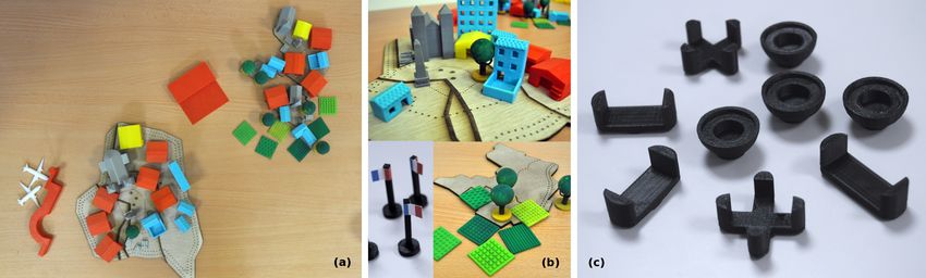
Multimodal Technologies and Interact. 2018, 2, 36                                                    2 of 20

guidelines [12,13]. Olfaction and taste in particular have been studied very little, whether inside or
outside the classroom. When they are, it often is for investigating the so-called Proust’s madeleine
effect, i.e., in the hope that associating an information with a specific smell will enable to better
recall it (e.g., [14]). Although many studies suggest so, others contest this fact (for a review, see [15]).
In addition, others argue that smell provides a sense of security, well-being, and pleasure [16], hence
that their usefulness resides in creating pleasant atmospheres improving focus.
      In other words, smell and taste in education are more often considered as useful to process
unrelated information, rather than meaningful on their own right. This might be because their
perception and interpretation is a highly subjective process: smells and flavors are considered difficult
to describe [17]. Thibaud, for instance, argues that “olfaction tends to produce overly diffuse and volatile
phenomena” ([18], p. 12), hence not necessarily adequate for studying and teaching geography. However,
this can also be seen positively. For instance, McBride and Nolan [19] argue, citing [20], that olfactive
components may enable learning experiences beyond language, in line with the desired embodied
and experiential approaches to learning. Moreover it might open, for visually impaired children, more
possibilities to participate and collaborate.
      Conducted as part of a larger participatory research project on technologies to teach geography
to visually impaired children, this study also finds its roots in existing special education practices.
The special education teacher involved in the research project wanted to better understand how some
of her hunches about pedagogy worked. One such hunch was to use food, e.g., to bring traditional food
from all continents in a lesson dedicated to learn to recognize continents and their features. She argued
it improved memorization for some of her pupils, which she thought could be explained by the theory
of learning styles, i.e., that children have a sense or a combination of senses of preference for learning.
However, this theory is controversial [21] and lacks empirical basis [22]. Furthermore, it does not take
into account smell or taste.
      We thus decided to further investigate the possible uses of smell and taste for teaching geography
at a primary school level, and how it can be articulated with traditional supports for geography
teaching: maps, hereby tactile. How do pupils try to make sense of this still unusual material,
in conjunction with the better-known map? How does the special education teacher support the
development of these interpretations? Multisensory material in the classroom has the potential to
support experiential and embodied learning: does it change the kind of geographic knowledge
discussed? To answer these questions, we take a case-study approach. We observed a lesson
using Mapsense, an interactive multisensory map mediating the use of smell and taste using tangible
interaction, designed with our participants.
      Using multimodal analysis, we discuss the meanings attributed to smellable and tastable cues by
pupils, and the ways the prototype itself shapes the possible classroom interactions. It provides concrete
examples of uses of smell and taste in learning to support pupils’ engagement with the geography
curriculum. More specifically, the findings suggest that the wide range of meanings that can be
attributed to these cues, their open-endedness, can open new spaces for discussion—in particular,
discussions on social (dis)advantages through stories about their social, spatial and emotional lives,
which they can then better situate in larger (spatial) dynamics. In doing so, it afforded the teacher
opportunities to further her pupils’ civic and citizenship education. This endeavor has implications for
pedagogical design beyond special education—our overarching goal being to draw opportunities for a
more inclusive curriculum and classroom, to invite all children in developing an emancipatory and
non-visual knowledge of geography.

2. Design of the Prototype
     MapSense is a multisensory map that relies on tangible interaction to mediate the use of smell
and taste (thereby also named smellables and tastables). This section describes the specific instance of
Mapsense used in the study below. The timeline in Appendix A gives an overall idea of the continuous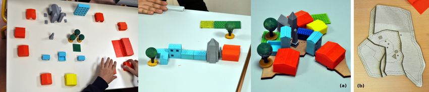
Multimodal Technologies and Interact. 2018, 2, 36 3 of 20
re-assemblages and transfers of design properties [23] that resulted in the instance of the prototype
presented here. It is also described in more detail in [24,25].
2.1. Process
In the design of Mapsense, children were considered as informers [26]. This means we took the
design decisions in agreement with the teacher, but these were inspired by multiple previous observations
and occasions for the pupils involved to express preferences or devices they would like to build.
2.2. General Setup
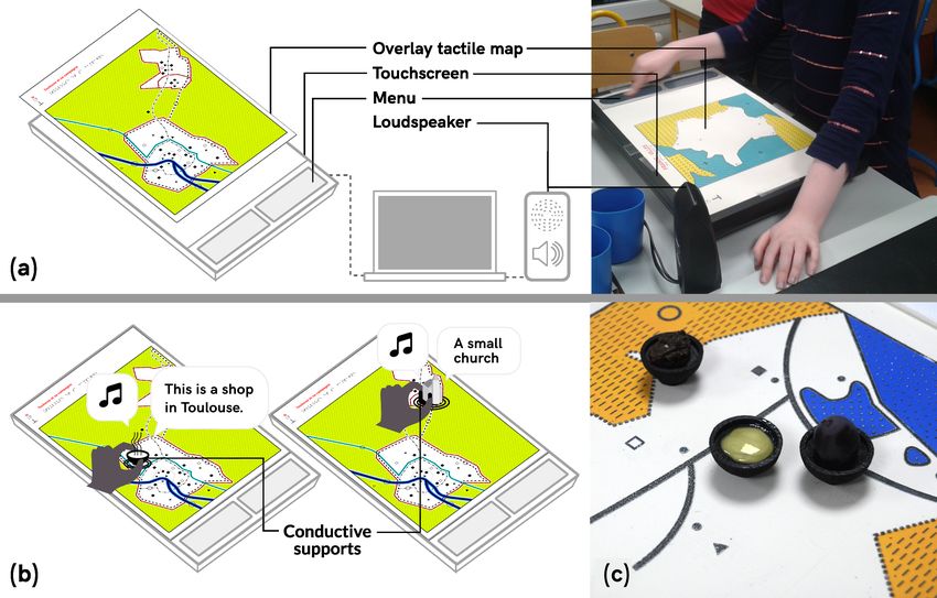
MapSense was based on an interactive audio-tactile map illustrated in Figure 1, and initially
designed by [27]. Its main components are a raised-line map overlay placed over a 27-inch touch
screen using capacitive projected technology, connected to a computer and speakers. Double tapping
on the screen provides audio information about map elements. In addition to the main display and
exploration area, the prototype includes a menu to access different types of information (e.g., points of
interests, or general directions, see Figure 2). It also enables the use of tangibles made of conductive
material, which can contain smellable or tastable material, as illustrated in Figure 1c.
Figure 1. (a) the main setup of MapSense consists in a touchscreen, a tactile map overlay and
loudspeakers. Double tapping on a map element triggers verbal audio output. (b) MapSense is
used with Do-It-Yourself tangibles, placed on conductive supports recognized as touch events. Some
tangibles are filled with smellable or tastable material. (c) on this screen size, three tangibles can be
used at the same time.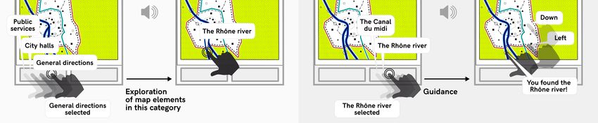
Multimodal Technologies and Interact. 2018, 2, 36                                                              4 of 20

      Figure 2. A swipe on the bottom left menu followed by a double tap allows the user to define the
      category of geographical information to display (e.g., cities). Then, the user can choose a specific point
      of interest within the current category, and is guided towards it with a second menu at the bottom right.

2.3. Interaction Principles
      Interaction was limited to specific interactive elements on the map, which were defined by their
coordinates, category (e.g., type of information, such as cities), and content (e.g., audio cues, such as
city names or sounds recorded in a given city). To trigger audio cues, users had to double tap on
interactive elements, which were indicated by a tactile symbol. Double-taps were used in order to
prevent unexpected audio cues during manual exploration. A double tap with a conductive tangible
had the same effect as a finger double-tap.
      The different types of verbal information delivered by the map are selected via a two-level
menu (see Figure 2). For the second sequence, for instance, pupils were invited to select points
of interest (e.g., city halls, private services, public services), general directions (e.g., roads, rivers,
map orientation), and audio discovery (e.g., playful cues for each interactive area). Pupils browsed
the categories by swiping, and selected a category by double tapping. Once one type of information
was selected (e.g., points of interests), all related interactive areas could be triggered by a double
tap. The audio discovery category provided non-verbal audio cues that had been recorded by the
children themselves (e.g., the sound of water, the sound of their white cane on the ground, or noises in
school). Furthermore, users could browse the names of all interactive elements available within each
category by using a second menu. A double tap on one of these elements activated verbal indications
(left/right/top/bottom) that guided the hand towards the target location.
      The design of the menu was based on the design of keys or legends for regular tactile
maps. Legends were structured around the different types of geographical information. In general,
when discovering a new tactile map, visually impaired people first read the legends [27]. Similarly,
in the prototype, students can go through the first menu, and then read the content within each
category (second menu). The guiding option allows pupils to find a point of interest by themselves
and thus to take full advantage of the interactive system.

2.4. Map
       We designed a colored raised-line map with the help of the teacher and a tactile document maker.
It illustrated the itinerary that the pupils followed during a class trip. It depicts one of France’s major
cities and the surrounding countryside, a small sized city and a village (see Figure 3a). Audio cues
recorded during that trip were associated with interactive elements. Thus, children could associate
their subjective experience during the trip with a geographic representation of the trip. The map was
produced on swell paper in A3 format, which is a format frequently used in the context of maps for
visually impaired people. A smaller (A4) non-interactive version of the map with written legend
(either in braille or in large characters) could be printed for each child to take home.
Multimodal Technologies and Interact. 2018, 2, 36                                                        5 of 20

          Figure 3. (a) the map design used during the second sequence; (b) the classroom environment.

Tangibles
     Our set of tangible objects illustrates literally [28] various objects that children had encountered
during a previous field trip and represents different kinds of urban settings. Their design follows
the recommendations and principles derived from previous uses of the same prototype (see [25]).
They could be used to trigger audio interaction on the map, or independently from the map. They were
designed in collaboration with the teacher, using feedback from the five children involved in the study
and represented:

•     housing: a farm, a building, two medium- and three small-sized houses;
•     shops: a grocery store, a bank, a restaurant and a supermarket;
•     services: two post offices and two schools of different sizes;
•     infrastructure: an airport, two planes;
•     green spaces: fields, parks and trees;
•     historical points of interest: churches, tombs, war memorial;

2.5. Olfactory and Flavor Cues
     We used six different smellables and tastables, related to different concepts the teacher wanted
the pupils to elaborate on. The teacher first identified several possible associations for each concept.
The associations that she proposed were guided by three principles:

1.    Similarity to something children had smelled during a previous field trip;
2.    Familiarity i.e., cues that all children are expected to have experienced in their daily lives;
3.    Or unknown cues that could introduce new experiences and meaning. Some cues were direct
      associations (e.g., colza oil for colza fields), others were metaphors (e.g., goat cheese for the farm).

     The teacher finally chose six cues that were easily available: (1) Pastries were used to illustrate
a bakery near the service provider’s building and the tertiary economic sector. (2) A sample of rubber
was used to represent the traffic, and thus the transportation infrastructure. (3) Fresh grass was
used to illustrate both green spaces in urban settings and on the countryside. (4) Strawberries were
used to illustrate raw products (in contrast with pastries). (5) Colza oil and goat cheese represented
the region’s farming and livestock. These were direct references to the field-trip undertaken earlier
in the pedagogical unit (see Appendix C). (6) Licking envelopes were used as a representation of the
postal infrastructure and services.
     The olfactory and flavor cues were contained in small, conductive 3D printed bowls in which
children could pick up with a small spoon (see Figure 4b), or distributed when the related topic
was discussed (e.g., envelope would not fit in the bowls). Using the bowls has several advantages:
pupils could easily manipulate them and place them on or around the map; they could contain any
kind of Do-It-Yourself scents and tastes (in comparison with a scent diffuser, which only provides
a limited number of synthetic scents); finally, pupils associated it with dinnerware.
Multimodal Technologies and Interact. 2018, 2, 36 6 of 20
Figure 4. (a) all tangibles designed for the study; (b) examples of tangibles: various buildings, flags and
green spaces; (c) conductive bowls (top right), and conductive supports for the other tangibles.
3. Methods: Study Design
3.1. Context
The study was conducted in the main building of a service provider for visually impaired children
situated in Toulouse, France (Centre d’Education Spécialisé pour Déficients Visuels; Institut des Jeunes
Aveugles (CESDV-IJA)). It provides education to children with visual impairments and assistance to
their families. It ensures adequate care (e.g., psychological assistance, psycho-motor and low-vision
skills, orientation and mobility training, etc.). It helps with the inclusion of visually impaired children
in mainstream schools. For that purpose, specialized teachers create accessible material that can
be used in mainstream classrooms. For example, they adapt graphical representations and books
(e.g., production of enlarged or braille documents, and tactile diagrams and maps). In addition,
the center provides professional training and autonomy skills to adults undergoing sight loss.
Ethics
When this research project began, the home institution of the field researcher did not have an
ethics committee. This was still common for social sciences research in France at the time. The research
team thus defined an ethical framework, with ongoing discussions to address dilemmas and improve
practices (following the recommendations of [29]). We followed the UNICEF guidelines on research
involving children [30], which are based on: (1) the respect of children’s cultures; (2) doing research that
benefits children and does not harm them; and (3) addressing issues of justice, by recognizing children’s
rights, encouraging them in formulating their views and aiming at improving their living conditions.
All prototypes used in the classroom were devised with the teacher according to her pedagogical needs
and the existing school culture (and were designed with the children as much as possible). We made
suggestions and presented possibilities, but the teacher always made the final decisions, with the
explicit goal of improving her teaching practices. Thus, the current study was entirely embedded
in children’s usual activities, did not change the content of the lessons and did not add a burden
on the children. The field researcher specifically asked for children’s authorization to work with
them, and reminded them regularly that they could refuse to participate (which they sometimes did).
Children received several gifts throughout the study (such as design probes which they could keep).
The researcher informed them about the research results and asked for their comments and inputs.
Children expressed their satisfaction regarding participation in the study and using the resulting
instructional technologies. They also reported that they felt like the field researcher was listening to
them and cared for their opinion. We presented the research goals and methods to parents of the
children and they gave informed consent. All teachers and caregivers (e.g., transcription specialists)
who participated in the project were compensated for the extra time they put in the project, according
to the legal hourly rate.Multimodal Technologies and Interact. 2018, 2, 36 7 of 20
3.2. Research Questions
This prototype and study were exploratory, as discussed previously. The research questions
synthesize the interests of the researcher and the special education teacher involved.
1. How can children best be supported in making sense of multisensory material and how can it
be integrated more often? What can we learn about children’s meaning-making processes when
using smell and taste in the classroom for geography courses?
2. Does multisensory material allow for more connections to be drawn between children’s lives,
geography field-trips, and the classroom?
3. How are these activities valued by pupils and teacher? Can this prototype be used to support
collaboration in children with diverse sensory perceptions and diverse background?
3.3. Activity Design
The activity was designed with the special education teacher, as part of her progression in
the skills base to be acquired by all French pupils (Domain 5: understanding space and time,
human organizations and developing citizenship [31]). The overall design of the pedagogical
units and its goals can be found in Appendix C. This session focused specifically on geographic
skills (e.g., reading and constructing a map) and revisiting the themes explored in earlier lessons a
month before. The main goal was to support a pupil-driven synthesis about the differences between
human habitats.
The first activity consisted of collaboratively building a physical layout of different types of human
habitats (e.g., a major city, a small city, a village) using the tangibles they had discovered in a previous
lesson. Children worked in pairs (C4–C5; C3–C1; C2 made his alone). Children chose the tangibles
they wanted to include, and then organized them on the table (see Figure 5). They were to discuss it.
The teacher regularly asked the pupils to orally describe what they were doing and why. In the C3–C1
pair, C3 led the activity. In the C4–C5 pair, the special education teacher assisted at every step, as this
pair did not manipulate the tangibles much. Both C2 and C3 tried multiple layouts and encompassing
or not the wood shape for support. C1 manipulated the tangibles a great deal, but rather as he was
using them to tell stories about the elements represented. We will not examine this part of the lesson,
but it contributes to explain existing classroom dynamics and particularly to show the difficulties
of collaboration.
Figure 5. (a) non-interactive models that children reconstructed using tangibles only. From left to right,
a major city (C3–C1), a village (C4–C5), and a small city (C1); (b) laser cut wood representation of the
shape of each city, which can be used with the tangibles.
The second activity was built around Mapsense. The teacher had a list of themes (see
Appendices C and D), which she introduced by a cue to be smelled or tasted. She first asked what
they thought it was, and what it represented. Each cue was associated with a step of the field trip
undertaken some time earlier. The pupils had time to discuss freely or to use the map to find what the
cue is associated with. She then asked a question (e.g., why do we build cities?) to which she indicated
they could answer using the cue and what they had just discussed. Note that only one child at a timeMultimodal Technologies and Interact. 2018, 2, 36 8 of 20
could interact with MapSense (although they disregarded this rule several times), and the others were
helping by providing suggestions or making hypotheses.
3.4. Participants
Five pupils participated in this study. Their demographic and other information are reported
in the Table 1. They attend different mainstream schools part-time (i.e., 3–4/5 days of the week)
and the same special education classroom the rest of the week. Their time in this special education
classroom is dedicated to developing specific skills (e.g., reading braille) and attending rehabilitation
sessions (e.g., mobility and orientation). They are either perceived as being able to perform well
academically but lacking motivation and resilience, or as unable to follow the same curriculum as their
peers. The socio-economic status (SES) reported follows the nomenclature used in French education
statistics. It includes four categories: disadvantaged, middle class, advantaged and highly advantaged,
which is defined by the household referent person’s occupational status.
Table 1. Information about the children who participated in the design of the probe and the study.
Id Gender Age Grade Impairments SES
Blindness with light perception, motor, memory
C1 M 10 3rd grade Disadvantaged
difficulties and psychological impairment
C2 M 11 5th grade Blindness with light perception Disadvantaged
C3 M 11 5th grade Severe visual impairment and dyslexia Middle class
C4 M 10 4th grade Severe visual and hearing impairment Advantaged
Blindness with light perception, multiple
C5 M 11 4th grade Disadvantaged
learning difficulties
We chose to work with these children for two reasons. The first was pragmatic: they were
the students of the special education teacher involved in the research project and would attend
the same classroom for two years. This meant being able to build a relationship with them and to
observe changes on the long run. The second was that it was a very diverse group on many aspects;
except gender, which is partly due to a gendered imbalance in the prevalence of visual impairments
and partly to gender differences in experiences of schooling and modalities of schooling thus proposed
by carers. This diversity poses additional challenges in pupils’ collaboration, which is an interesting
way to test the limits of a given intervention.
A special education teacher with seven years of experience was involved in the study. She
designed the activity led, asking for the field-researcher’s inputs as to how to best make use of the
map. She tasked her with sustaining children’s engagement by asking questions or answering theirs.
3.5. Procedure
The children were familiar with the interaction principles. The audio-tactile map had been in
use for over a year [24] and we had organized a similar activity 10 months earlier [25]. The teacher
reintroduced the map and described its functioning (particularly the menu) before beginning the activity.
We assisted children when they encountered issues with the prototype (mostly unrecognized taps)
and took over the class discussion when the teacher focused on explaining a concept to one child in
particular. Immediately after the lesson and a few days later, we interviewed to get her analysis on
how the activity unfolded and on perceived learning outcomes. We also interviewed each participating
pupils a few days after the lesson.
3.6. Analysis
The data on which the analysis was conducted consisted of:Multimodal Technologies and Interact. 2018, 2, 36 9 of 20
• 1:41 h of video from the third lesson of the sequence (see Appendix C);
• Three interviews with the teacher: one before the three lessons to define the content, two after the
lesson presented here. These last two interviews investigated among other things her assessment
of learning outcomes;
• Semi-guided interviews with the children, conducted after this study. We discussed the session,
what they remembered from it and the goals of learning (this last topic was useful for
understanding how they perceived this unit compared to their other school experiences).
To analyze the activity, we relied on multimodal analysis [32]. It provides concepts and tools to
study interactions and the construction of meaning. We first transcribed the video data to identify:
1. Broad phases in the lesson: subtasks, moments of switching from a theme to another;
2. Modes of interaction: overall classroom setting including the types of interactions with the
map, speaker, utterance, gestures, gaze, olfactory representation, gustatory representation,
and tangibles. Here, gaze is mainly denoted by body orientation, which suggests efforts to
listen, focus on manipulation, etc.
An excerpt of the transcription can be found in Appendix B.
This type of transcription enables seeing similar interactions in different events, which gave shape
to the themes outlined in results. Our iterative analysis focused on semiotic chains, i.e., the diverse
association of meanings across different representations and modes. For example, what kind of
associations do the different types of representations elicit? How does it inform us about the potential
uses of smell and taste in the classroom? We also focused greatly on the spatial occupation of the
classroom: the different representations and artifacts may have intrinsic qualities supporting a specific
emergence of meaning, but they are also spatially distributed in the classroom, which makes them
individual or group resources, enabling certain kinds of social interactions but not others. In the
analysis below, we sometimes use observations from the earlier ethnographic study, to contrast or
complement the observations made in this lesson.
4. Findings and Discussion
All pupils reported having enjoyed the activity. They all engaged with each of the resources
brought to the classroom. We structured the findings around four key themes to understand how
Mapsense reshapes learning: smell and taste in geographic reasoning; children’s efforts to reclaim the
space of the classroom; personal and emotional engagement; and a more general discussion of the
implications for citizenship education.
4.1. Smell and Taste: (in)Congruities
In this section, we look at how olfactory and gustatory representations were interpreted, and how
this interpretation was intertwined with the other representations of the same concept (e.g., tangible
objects, tactile map). We discussed the Proust effect above, and we propose here to be attentive to the
congruities identified by children across multiple situations when interpreting olfactory and gustatory
cues, to how they can be part of “the re-representation process incorporat(ing) the interaction and context of
preceding activities and project(ing) them into subsequent activities” [33].
For instance, during the first lesson of the unit (see Appendix C), the children visited a farm
dedicated to the raising of livestock, which they identified primarily through smell. During the
second lesson, they manipulated a tangible representing a farm building. In the third, the farm
was represented by the model, the sounds of farm animals played on the map and the goat cheese.
During the classroom discussion, we aimed at getting children to formulate that farming was an
economic sector that encompassed multiple activities related to the production of food. Note that in
French, their names are not related: ferme for farm, and agriculture or agriculture et élevage for farming.
The teacher asked the group if they knew other places that smelled like a farm. C1 answered that
he knew a similar place that smelled of olives. This was a recall of a class trip that occurred nineMultimodal Technologies and Interact. 2018, 2, 36 10 of 20
months prior, during which they visited an olive farm. The smell of an olive farm is extremely different,
so the convergence between the two was not easy to perceive—except for the fact both are farming
activities—a concept that children were then able to manipulate to apply to another cue (strawberries)
and to a different question (“Why do we build cities?”). However, the convergence might actually be
found elsewhere: this might be an especially strong association because visiting farming spaces often
includes a time dedicated to tasting the produce of the farm. We discuss this below, in connection to
children’s spatial, emotional and social lives.
However, tastable and smellable representations seem useful to open up a breadth of
meanings—or, in the words of C3, to encourage “answers that sound silly”. An example of these
types of answers: To the question “what feels different in the city and the countryside?,” C2 answered
“the lack of space”. However, upon the presentation of rubber from a tire, he gave a different answer
(“pollution!”) and went on explaining and discussing with C5 why cities feel more polluted:
C5: “it smells like cars”
C2: “because there are more cars, because there are more humans”,
or, in other words, less space for individuals. C2’s initial answer was a reference to a bodily and
personal experience, but it is the smell of rubber that makes it fit into a larger pattern Let’s note
the pollution due to agricultural activities was not discussed. It creates a false dichotomies between
cities and countryside, or culture and nature. However, this should be understood as a first step
to understand the link between human activities and pollution, which harnesses children’s beliefs
about the difference between the countryside and cities, enabling appropriation. Here, the congruity
between the experiences and the representation in the classroom is very visible: C2 discussed the lack
of space as affecting the ability to breathe—When manipulating the rubber C5 turned his head away
to signify disgust, and C1 agitated his hands under his nose as if he was dissipating the odor. This is a
particularly evocative representation of pollution. It is also an unpleasant one, which might be a limit
of this approach (see Section 5).
We had indeed included rubber in the lesson to suggest urban pollution and more specifically
to discuss the roles of urban centers in the development of the industrial sector. Its interpretation as
a proof of car pollution and population density is interesting because it connects different aspects
of the same issue i.e., the spatial distribution of jobs that affects their family lives. In other words,
the potential uses of smell and taste in education go far beyond their use as a memorization technique
or as a tool to lessen learner’s anxiety. They enable a situated interpretation and learning process,
and grounds learning in pupils’ everyday lives.
These two examples inform us on olfaction and taste as modes too. There can not be a single
interpretation of these cues. They are dependent on the learning context in which they are introduced
to a higher degree than, say, a map. The map has a legend and many indications about what it
represents and how it fits with other representations of the same kind (e.g., indications of scale and
orientation). Here, this context is provided by the themes of the unit and the other representations
available in the classroom.
4.2. Reconfiguring Space
In this section, we turn to the spatial interactions enabled by the apparatus (see Figure 3 for a
visual depiction of the classroom setting). We address this at the level of the classroom and at the
level of the map. MapSense shaped what was allowed in the classroom, especially moving around.
In addition, the fact that only one child at a time could interact with the prototype offered new
pedagogical opportunities.
First, a few notes on the roles undertaken by C1 in the classroom. This pupil usually is not eager
to participate in group activities. However, his known sensitivity to olfactory stimuli became part
of a collaborative construction of knowledge. C3 particularly marked his interest to support C1 and
C5’s participation in the follow-up interview (“they feel good, they dare to say things”). Although he wasMultimodal Technologies and Interact. 2018, 2, 36 11 of 20
usually withdrawn in the classroom, we noted a very different pattern of engagement during this
lesson: he turned towards his peers and made tangibles fly to nearby desks...
As Mapsense is currently implemented, it is preferable that only one child at a time interact
directly with the tactile map. When several pupils interact, the audio indications are played at the
same time, rendering them inaudible. In this activity, the pupil interacting directly with the map was
verbally guided by the others and was in charge of verifying or generating hypothesis by interrogating
the map. During this time, the other pupils were free to manipulate the unused tangibles scattered on
their five desks. The tangibles were especially used to compare scales and quantities—for example,
comparing the tower’s height with that of the countryside house, or the number of buildings in the
city. However, to do so, they had to be exchanged or manipulated, which requires moving around the
classroom during discussion. Furthermore, not only does Mapsense require taking a turn, but if a pupil
thinks he knows how to find the needed information from the map, he is invited to guide the hand of
the current user, or bring him the related tangible. Space was thus constantly renegotiated, as a result
of Mapsense’s integration in the classroom. This is in stark contrast with the previous lessons observed.
Fixed seating is generally considered an asset because it enables finding needed material (e.g., pens,
documents) quickly. Additionally, it provides new perspectives from classroom-size geographical
representations.
Let’s discuss this adaptation process. When it was initially introduced in the classroom,
MapSense was used by the teacher as a tool to discover the general content of the map. One student
interacted with the prototype, while the teacher described the current interaction, with all other pupils
surrounding them. The rest of the lesson relied on individual paper maps distributed to each pupil.
Later on, the teacher developed a more collaborative pedagogical scenario: the student exploring
the map described his actions and perceptions, while the others reconstructed the exploration on
their own paper map. Finally, during this study, MapSense was used as a tool for collaborative
inquiry, which the teacher described as a step towards understanding its full pedagogical potential.
This changed the way the map was explored.
On a tactile paper map, or on an interactive map without tangible interactions, these pupils are
taught to read linearly (e.g., starting from left to right and top to bottom). Carers often argued it enables
developing a survey knowledge of space, providing more precise and generalizable representations.
With MapSense, pupils were rather encouraged to focus on finding a point of interest or to discover the
map by following routes that interest them, i.e., to develop a route-based knowledge. Previous studies
have suggested that those two kinds of knowledge are complementary and build upon each other [34].
What a route-based exploration of the map enables is the grounding of personal stories in a global
representation. As planned, the pupils first tried to follow the previous class trip, which started from
the special education center on the map. C4 proceeded to find the nearby bakery, from which the
pastries they had eaten came from and is a popular place for them. We had made a point of interest for
this bakery, as we know their attachment to this place.
4.3. Making the Classroom Pervasive to Children’s Lives
As discussed above, Mapsense is inspired by a model of education situated in children’s
experiences and everyday lives. Hence, the decision to use children’s audio recordings, and the
route-based reading of the map. Additionally, with the teacher, we had hypothesized that using
smellable and tastable material participates in fostering engagement with the content of the course.
It also facilitated the introduction of children’s narratives about their spatial, emotional and social lives.
We can identify three types of experiences to build on: joint experiences, that the group has had
together; shared experiences, such as experiences of similar places, which they compare and talk about;
and individual experiences, which they do not necessarily like to share. For instance, C5 did not share
his wish of traveling as an adult during the lesson. From here on, we will try to identify implications
for socio-constructivist pedagogies, demonstrating that different forms of learning are at work. To do
so, we follow the typology outlined by [35]: “Knowledge construction recognizes that individuals createMultimodal Technologies and Interact. 2018, 2, 36 12 of 20
meaning for themselves rather than just receiving it preformed from others; collaborative knowledge construction
more specifically locates this meaning-making in a group context; intersubjective learning further specifies that
the process of meaning-making is itself constituted of social interactions; and knowledge building requires that
this group-based meaning-making is being done intentionally.”
4.3.1. Children’s Spatial Lives
This case study was on regional geography and we had designed the map to reflect what we
knew of pupils’ joint experiences of the neighborhood (e.g., we represented the postbox, grocery store
and bakery they like), so it is not surprising that children had related stories. The lesson apparatus
afforded a way of grounding their stories in social and spatial structures—but also to reflect on their
own lives using geographic tools.
We discussed above the interpretation of rubber as a sign for pollution and how it opened up a
space for discussing familial struggles with spatial mobility. The stories told by children often focus on
the spaces they know best: their home and the journey to the service provider’s building in which
this lesson unfolds; the direct neighborhood of this organization (the park, the bakery, the canal,
the post box, the museum and its mummy); the mainstream school they attend; previous field-trips;
family members’ homes. They can all be situated on the map, or evoked in relation with the tangibles
(e.g., C5 “Me, I live in a building”) and the smellables and tastables (e.g., C1 “We get pastries when we
pass by the bakery!”). Those are shared and joint experiences that allow for intersubjective learning and
knowledge building.
Intersubjective learning is not restricted to the group of pupils or the classroom C5, in a follow-up
interview: “Eating, and the sounds, it helps me understand, and think. Maybe it helps me remember. But that
I don’t know. It helps me think about things I can do when I grow up in a long time.” We discussed
cognitive theories, arguing that smell or taste might foster memorization when associated to a chunk
of information. We argue this is different: here, learning is “a process that constructs personal identity,
entwining individual learning with group practices that themselves can change” ([35], p. 4). C5 memorizes
what he finds useful for the future, that coincides with what he thinks adults do, which will enable
him to participate in society.
4.3.2. Children’s Emotional and Social Lives
In C5’s case, the use of food is especially relevant. He is overweight and often experiences
negative remarks when eating, from peers and carers. During a previous discussion, he expressed his
frustration: “people say it’s my fault if I’m fat, but it’s not!”. This was in contrast with the situation in the
classroom where tasting food was a valid way to contribute to the activity—we also had chosen the
pastries as tastables to provide an enjoyable lesson experience. C5’s bodily, emotional and social lives
are here intertwined. Food access and health are strong markers of one’s socio-economic context [36,37].
It is not only his weight that sparks remarks, but also the fact that carers attribute it to faulty parental
food practices that need to be corrected for C5’s good. Using tastable material necessitates taking stock
and engaging with these highly social and personal experiences of food—which can become a subject
of geography.
There is ample work on mobile and multimodal technologies to scaffold learning and reflection
in the wild. However, less attention is given to bodily experiences and emotions in classroom-based
activities. This was the case of the earlier example on rubber, pollution and bodily experiences of
the city. In the follow-up discussions, the group discussed spatial inequality. C2 talked about feeling
betrayed, after being promised that life would be better in the city but having to live in cramped high
rise towers: “Cities are for stockpiling people,” he said. For those living in the countryside (C3 and C5
especially), the main concern is the lack of potential jobs. This apparatus provided an outlet for vivid
social experiences related to the differences of human habitats. We would argue this opens up an
opportunity for them to understand the impact of policies, but also to transform individual issues intoMultimodal Technologies and Interact. 2018, 2, 36 13 of 20
community ones, i.e., to support knowledge building communities. We note however that this was not
an aim of the teacher, hence that it should here be considered as intersubjective learning.
Spatial experiences are imbued with emotions [38]; and emotions are both personal and
intra-personal processes [39]. Let us clarify: to identify a given bodily experience as an emotion,
one must have the ability to name it, borrowing from a set of available cultural resources. For example,
pastries are not only appreciated because of the sugar they contain but also because getting them is a
social event; when they find cities suffocating, the pupils refer to familial discourses and academic
discourses. Cities are this way because they have “too much CO2 [carbon dioxyde]” (C2), but also
because their parents say so (C1). The interest of this activity is that, by asking explicitly to discuss
experiences, it lays bare the many associations of meanings, the value judgments, made by children in
their everyday lives. It confirms our previous observation about this apparatus as the support and the
tool for intersubjective learning.
4.4. Opportunities for Citizenship Education
Therefore, it affords many opportunities for an emancipatory curriculum and the development
of knowledge building communities, or at least for an education oriented towards the development
of citizenship. This includes fostering integration in society by raising societal and cultural questions.
Another example of this was related to gender equality... and strawberries. The strawberries and
the pastries were there to discuss the three economical sectors. However, C2 refused to eat them,
protesting they were for girls only. When asked by the teacher why he thought that, he could not
answer. It transformed into an unforeseen opportunity to address gender biases for the teacher.
She asked all the other pupils whether they liked strawberries, and the group concluded that boys
like strawberries too. Previous research has demonstrated that boys are actively discouraged from
expressing and reflecting on their emotions, which creates behavioral issues [40]. Creating a space
where expressing emotional experiences is safe thus can impact different aspects of gender inequalities.
The multisensory approach facilitated discussions about situated social issues needing to be
addressed in this context, but go beyond the geography curriculum. However, it is not without
difficulties. Addressing any of these issues in the classroom is not necessarily well-perceived.
For instance, a book made by the French government to address gender inequalities in all classrooms
was censored in 2014 [41]. Pragmatically, teachers might prefer to prepare and control debates on
certain subjects. The breadth of meanings emerging from the use of smellables and tastables is not
necessarily considered desirable.
Then, how might this generalize to material pupils have never encountered before? Do these
modes depend on previous life experiences? Even the licked envelopes, although they had never
been used with the children, were not completely unknown: they have gone to the post-office or the
post-box before. As far as can be known from this study, this type of material for not-yet-experienced
geographic topics and spaces opens up potential futures as much as it supports engagement with past
and present issues.
5. Perspectives and Future Work
In this section, we propose to outline implications for practitioners, the design of multimodal,
multisensory, systems as well as a few perspectives for future research. Let’s begin with implications
for deployment in other contexts. For those who would want to implement these types of approaches,
there are a number of difficulties and questions to address, especially regarding larger groups of pupils.
Is it possible to use this type of system with a larger group, or should it be divided into smaller groups?
Would a mixed-gender group react the same way? How can all pupils be made to feel comfortable
to talk about their spatial experiences? Based on our preliminary experiences, forming small groups
is preferable in order to make pupils comfortable, but further research is needed on the design of
adequate learning activities.Multimodal Technologies and Interact. 2018, 2, 36 14 of 20
Moreover, the use of smell and taste raises specific issues of trust. Some are practical and can
be addressed during the implementation. For instance, if we were to use a device to simulate taste,
we would need to prove that the device is perfectly clean before using it or the parts used would need
to be disposable (which was the case of MapSense and its spoons). Other issues are more difficult
to address. For instance, how do we handle likes and dislikes in terms of flavors? Do we have to
only choose eatables that children are likely to appreciate? How do we introduce unknown tastes in
the classroom?—hence the issues of trust, and its entanglement with pleasantness. The smell of the
rubber was highly unpleasant. However, C2 notes that, in this context, trust having been acquired,
this unpleasantness is acceptable (C2: “that’s at school so it’s okay to try”). Another line of inquiry is the
use of multisensory interactions for creating pleasant learning experiences. It is consistent with the
installation of multisensory rooms in special education institutions, which we previously discussed
in [42]. In that case, there would be a need to research and accommodate group preferences as well as
their potential evolutions. Moreover, given the scent-free policies are implemented in public spaces
in different countries, the use of smell to create an atmosphere might be a difficult endeavor. Finally,
we make a note on the choice of tastables and smellables, in order to complement the description
of our process in Section 2. Here, the choices were simple because the lesson was based on a field
trip, during which we had observed with the teacher the kind of cues pupils had noticed. However,
the activity could be to ask pupils to bring something to eat or something to smell that they think is
related to the theme of the next lesson. This study focuses on reviewing and synthesizing previously
studied concepts, but a previous deployment was for introducing a new topic. Those are the two types
of lessons for which this apparatus seems best suited, at this stage.
Regarding the design of multimodal systems, we hope this case study convincingly demonstrated
that these sensory experiences should be considered as culturally shaped, and potentially useful
modes of communication. There is still much work to be done on how smellables and tastables
can become useful representations, especially in other disciplines. These modes may be primarily
suited for teaching social and human sciences. Although baking can be used to teach some areas
of mathematics [43] or physics or chemistry [44], it does not exploit the serendipity of this type of
material that makes them so useful in our case study. Those are both design and didactic questions that
should be developed in future research. Another approach would be to focus on skills. For example,
Metatla et al. [45] has proposed the use of multisensory systems to support storytelling and social skills.
6. Conclusions
Our study shows how the use of ‘smellables’ and ‘tastables’ as representations in geography can
lead to grounding geography concepts in personal experiences—and this can enable children to reflect
on how their lives are shaped by larger spatialized dynamics. They are never interpreted alone: their
interpretation emerges from the creation and association of meanings across the map, the small scale
models and the collective discussion. They seem to elicit more personal stories than any of these other
modalities. We can hypothesize that welcoming the use of smell and taste in the classroom legitimates
these recollections—maybe because they are deeply rooted in everyday experiences.
These findings can inform the design of learning activities or of learning technologies. Smell and
taste are not commonly used in technologies given the technical difficulties they still pose. However,
as has been shown, they can be integrated into learning activities. With the growing interest in
embodied learning experiences in many curriculum areas, this study can inform future research and
practices from two aspects.
Firstly, it shows how to shape the meanings associated with a given cue. Whereas the interactive
tactile map acts as a frame of reference, olfaction and taste are invitations to deepen a specific theme
through discussions. In contrast, audio cues made by children and used on the map seem to support
a different type of engagement [25]—one that is more playful and imaginative. Though both hold
promises of bridging experiences and classroom-based learning, they do so in very different ways.Multimodal Technologies and Interact. 2018, 2, 36 15 of 20
Secondly, smell and taste are not necessarily useful for all curriculum areas. However, their use in
the classroom blurs the difference between in situ and classroom-based learning, which can open up
new perspectives at a time when there is a push towards less costly and easier to manage virtual field
trips. Instead of going for primarily visual experiences of landscapes, this is an invitation to envision
a different path for experiential learning in the classroom, one that would take into account sensory
diversity in learners.
Author Contributions: E.B. did the field-research and conducted the experiment. She designed the experiment
and analyzed the results under the supervision of G.B., A.B. and C.J. participated in research discussions about
the project and designed and provided the initial prototype (the interactive audio-tactile map). All authors were
involved in writing the paper.
Funding: This research was funded by the French National Research Agency grant number ANR-14-CE17-0018.
Acknowledgments: This work was supported by ANR-14-CE17-0018 (Accessimap). We thank “Cherchons pour
Voir” lab and Institut des Jeunes Aveugles de Toulouse, as well as all the students and teachers involved in
our study.
Conflicts of Interest: The authors declare no conflict of interest. The founding sponsors had no role in the design
of the study; in the collection, analyses, or interpretation of data; in the writing of the manuscript, and in the
decision to publish the results.
Appendix A. Timeline of Design Iterations
October 2014. This was the beginning of the field-study. Caregivers demonstrated great interest in
digital fabrication techniques. We accompanied them to the local Fablab and provided information on
tools. During observations at the school, we observed the use of toys or scale models to help children
manipulate spatial representations. It was often used in mobility and orientation therapy, to explain
three-dimensional spatial concepts, such as altitude or being on top/under something. A special
education teacher described her pedagogy as inspired by theories on learning styles. She demonstrated
it, taking the example of a kinesthetic approach i.e., she uses the feel of movement to explain a
concept: to teach numbers, she used a different object, doing a different movement, a number of times
(e.g., ten was represented by a toy car jumping ten times).
We also observed several activities related to olfaction and taste. For a lesson on world geography,
the teacher offered pupils the chance to try food typical of certain places. We also observed that many
children refused to play to the Fragrance Loto game. This game consists of matching a scent enclosed in
a box with its image. The reasons all the students gave to refuse to play it were related to its perceived
low quality: “fake,” “artificial,” “cheap”...This is why we used actual food instead of artificial flavors,
with MapSense.
January 2015. We designed and 3D printed a tactile globe to gather insights on the relevance of this
technology and the potential uses of Do-It-Yourself 3D representations in the classroom. Its affordances
triggered interesting behaviors: children would use it as a ball to play, they would share it, or throw it
to one another, etc. They seemed to allow for ludic storytelling in the classroom. The teacher outlined
that it had a positive impact: It successfully triggered children’s interest and contributed to their
representations of space.
February 2015. An interactive map using a raised-line overlay (based on [27]) was implemented
in the special education center. It was adopted by several teachers and therapists, and children gave
positive feedback on its use (see [24]).
June 2015. The field researcher organized a brainstorming session with caregivers and children
on the interactive map’s benefits and limitations. This allowed us to identify a major additional
need: providing a wider variety of cues and representations to support the pedagogy used with
children living with multiple impairments (e.g., deafblind, learning difficulties). It was not sufficient
to bridge the gap between children’s experiential knowledge (e.g., class trip) and a two-dimensional
representations (e.g., map). During the discussion on the potential means to bridge that gap, caregivers
insisted on the fact that the chosen technologies should be as cheap and easily customizable as the
audio-tactile map.You can also read