Appendix D The Regional Transportation Plan 2018 - Regional Air Quality Conformity Analysis - Puget ...
←
→
Page content transcription
If your browser does not render page correctly, please read the page content below
The Regional Transportation Plan — 2018

                  Appendix D
                Regional Air Quality
                Conformity Analysis

 May 2018                  Puget Sound Regional Council
May 2018
Funding for this document provided in part by member jurisdictions, grants from U.S. Department of Transportation,
Federal Transit Administration, Federal Highway Administration and Washington State Department of Transportation.
PSRC fully complies with Title VI of the Civil Rights Act of 1964 and related statutes and regulations in all programs
and activities. For more information, or to obtain a Title VI Complaint Form, see https://www.psrc.org/title-vi or
call 206-587-4819.
Americans with Disabilities Act (ADA) Information:
Individuals requiring reasonable accommodations may request written materials in alternate formats, sign language
interpreters, physical accessibility accommodations, or other reasonable accommodations by contacting the ADA
Coordinator, Thu Le, at 206-464-6175, with two weeks’ advance notice. Persons who are deaf or hard of hearing may
contact the ADA Coordinator, Thu Le, through TTY Relay 711.
Additional copies of this document may be obtained by contacting:     Puget Sound Regional Council
                                                                      Information Center
                                                                      1011 Western Avenue, Suite 500
                                                                      Seattle, Washington 98104-1035
                                                                      206-464-7532 • info@psrc.org • psrc.org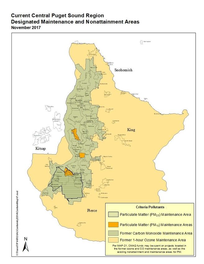
APPENDIX D: Regional Air Quality Conformity Analysis

INTRODUCTION
This paper documents the positive air quality findings of the Regional Transportation Plan (RTP)
for conformity with the State Implementation Plan for Air Quality (SIP). Required under the
federal Clean Air Act, a SIP provides a blueprint of how current and former nonattainment areas
will meet and maintain the National Ambient Air Quality Standards (NAAQS). Positive findings of
conformity are required by the federal Clean Air Act, the Fixing America’s Surface
Transportation (FAST) Act and the Washington State Clean Air Act. A positive conformity finding
will allow the region to proceed with implementation of transportation projects in a timely
manner.

As demonstrated in the sections below, PSRC has determined the RTP conforms to the
Washington State Implementation Plan as required by the federal Clean Air Act and the state
Clean Air Act. This includes an emission analysis demonstrating that on-road transportation
emissions are expected to be below the motor vehicle emissions budgets specified in the State
Implementation Plan (SIP).

Transportation conformity is a mechanism for ensuring that transportation activities -- plans,
programs and projects -- are reviewed and evaluated for their impacts on air quality prior to
funding or approval. The intent of transportation conformity is to ensure that new projects,
programs and plans do not impede an area from meeting and maintaining air quality standards.
Specifically, regional transportation plans, improvement programs and projects may not cause
or contribute to new violations, exacerbate existing violations, or interfere with the timely
attainment of air quality standards or the required interim emissions reductions towards
attainment. Meeting conformity requirements takes the collective participation of all jurisdictions
and agencies that implement transportation projects and programs within the central Puget
Sound region.

AIR QUALITY STATUS
Air quality conformity must be addressed for areas designated by the U.S. Environmental
Protection Agency (EPA) as nonattainment or maintenance for specific pollutants. This section
outlines the status of the Puget Sound region for each of the six criteria air pollutants and the
respective obligations related to transportation conformity.

The federal Clean Air Act requires EPA to set National Ambient Air Quality Standards (NAAQS)
for six criteria air pollutants: particulate matter (fine particulates, PM2.5, and coarse particulates,
PM10), ground-level ozone, carbon monoxide (CO), sulfur oxides, nitrogen oxides (NOX), and
lead. Areas of the country where there have been exceedances of the NAAQS may be
designated by the U.S. Environmental Protection Agency (EPA) as “nonattainment” for a
particular pollutant. The Clean Air Act requires states to develop a general plan to attain and
maintain the NAAQS in all areas of the country and a specific plan to attain the standards for
each area designated nonattainment for any pollutant. These plans, known as State
Implementation Plans or SIPs, are developed by state and local air quality management
agencies and submitted to EPA for approval. A nonattainment area that has demonstrated
pollutant concentration levels below the NAAQS may be redesignated to attainment. These

Regional Transportation Plan
Appendix D: Regional Air Quality Conformity Analysis                                                  1

areas are subject to an EPA-approved maintenance plan that is included as part of the SIP, and
are commonly referred to as maintenance areas.

Within the Puget Sound region, there is currently a PM2.5 maintenance area and three PM10
maintenance areas. The region is in attainment of all other criteria pollutants. Figure 1 on the
next page shows the location of the current, and former, nonattainment and maintenance area
boundaries. More information on these areas is provided below.

In 2008, a portion of Pierce County was designated as nonattainment for PM2.5. This area is
located in the Wapato Hills-Puyallup River Valley area near Tacoma. Effective March 12, 2015,
the region was redesignated by the EPA as attainment with an approved maintenance plan for
PM2.5. PM2.5 nonattainment and maintenance areas must consider sources of indirect PM2.5
emissions because they can result in formation of PM2.5 emissions. NOX is considered a PM2.5
precursor; therefore, NOX emissions are addressed as part of the PM2.5 conformity
demonstration. Other pollutants can be considered PM2.5 precursors but were not identified in
the SIP as having a significant contribution to PM2.5 emissions within the maintenance area.

In 1987, the industrial areas of the Seattle Duwamish River, Kent Valley and Tacoma Tideflats
were classified as nonattainment areas for PM10. The three PM10 areas were redesignated as
attainment with an approved maintenance plan effective May 14, 2001, after years of meeting
the NAAQS. In December 2013, EPA proposed the approval of a limited maintenance plan for
the three PM10 areas. A limited maintenance plan is used to meet Clean Air Act requirements for
formerly designated nonattainment areas with little risk of violating the PM10 NAAQS again. All
three areas currently have monitored PM10 levels that are roughly one-third of the PM10 NAAQS,
with steady declines in emission levels since the areas were first designated in 1987. EPA
approved the limited maintenance plan for conformity purposes on May 30, 2014, resulting in a
regional emissions analysis no longer being required to demonstrate conformity for the three
PM10 areas.1 EPA released the final approval of the limited maintenance plan on August 20,
2014.

In 1978, the central Puget Sound region was classified as a nonattainment area by EPA for
carbon monoxide (CO). In 1996, having met the federal standards for several years, the region
was redesignated by the EPA as attainment with an approved maintenance plan for CO. On
October 11, 2016, the area reached the end of the 20-year maintenance period for CO;
transportation conformity is no longer required for CO in the region as of this date.

The region was previously a maintenance area for the original 1-hour ground-level ozone
standard; a newer standard based on an 8-hour average concentration replaced the 1-hour
standard as of June 15, 2005. The 1-hour standard was revoked, and conformity no longer
applies. The region is currently designated as Unclassifiable/Attainment for the 8-hour ground-
level ozone standard. The former ozone maintenance area is included on the map in Figure 1
because the area is still eligible for funds from the Congestion Mitigation Air Quality (CMAQ)
Program.

1 Additional
           requirements still apply under a Limited Maintenance Plan, including consultation, the implementation of any
outstanding TCMs, and project level analyses.

Regional Transportation Plan
Appendix D: Regional Air Quality Conformity Analysis                                                               2
Figure 1

Regional Transportation Plan
Appendix D: Regional Air Quality Conformity Analysis   3

CONFORMITY ANALYSIS REQUIREMENTS
Transportation conformity is required by the Clean Air Act section 176(c) (42 U.S.C. 7506(c)) to
ensure that federal funding and approval are given to highway and transit projects that are
consistent with ("conform to") the air quality goals established by a SIP. Conformity to the
purpose of the SIP means that transportation activities will not cause new air quality violations,
worsen existing violations, or delay timely attainment of the NAAQS.

Section 93.109 of the federal conformity rule identifies the applicable criteria and procedures for
determining conformity of transportation plans, programs and projects, which are further
detailed in sections 110-119. The sections applicable to plans are summarized below.

    Section 93.110:        The conformity determination must be based on the latest planning
                           assumptions.2
    Section 93.111:        The conformity determination must be based on the latest emissions
                           estimation model available.
    Section 93.112:        The MPO must make the conformity determination according to
                           consultation procedures identified in the conformity rule.
    Section 93.113:        Plans and TIPs must provide for the timely implementation of transportation
                           control measures (TCMs) from the applicable SIP.
    Section 93.118:        Regional emissions must be less than or equal to the motor vehicle
                           emissions budgets established in the applicable SIP or submitted SIP
                           revision.

Latest Planning Assumptions
The federal conformity rule includes procedures for estimating regional emissions for
transportation conformity analyses (§93.122). The process for estimating regional emissions for
conformity analyses involves the integration of PSRC’s land use and travel demand modeling
with EPA’s emissions factor model. The land use and travel demand modeling must be based
on the latest planning assumptions. The following sections describe the technical analysis used
for the RTP conformity analysis.

Land Use Modeling
PSRC used an application of the UrbanSim land use model system to develop a land use
allocation product called Land Use Vision (LUV). LUV projects growth in the PSRC region
through 2040 and was developed through the following process. First, the PSRC Regional
Macroeconomic Forecast supplies regional totals for population, households, and jobs. Second,
the Macroeconomic Forecast is apportioned to annual jurisdictional control totals using numeric
policy guidance from the Vision 2040 Regional Growth Strategy and adopted local growth
targets. Third, the control totals are used in UrbanSim to allocate projected growth on
developable land at the parcel level. Fourth, the model results are shared with and vetted by

2This requirement is further clarified in the joint FHWA/EPA Memorandum, “Guidance for the Use of Latest Planning
Assumptions in Conformity Determinations,” dated December 2008.

Regional Transportation Plan
Appendix D: Regional Air Quality Conformity Analysis                                                                4
local planners, and post-modeling adjustments are made to better reflect adopted local policy.
Lastly, the LUV dataset is converted into the applicable formats for use as input in the regional
activity-based travel demand model.

The technical and policy assumptions underlying the LUV dataset were established to ensure
federal air quality conformity analysis requirements regarding use of “latest available planning
assumptions” were met. The key assumptions are as follows:
    •    The LUV dataset is consistent with the region’s most current long-range regional
         forecast of households, population and employment from the 2015 Regional
         Macroeconomic Forecast
    •    The LUV dataset reflects the regional long-range strategic growth assumptions as
         detailed by VISION 2040 Regional Growth Strategy
    •    The LUV dataset is reflective of locally adopted growth targets and comprehensive plans
         developed to begin implementing the VISION 2040 Regional Growth Strategy

Travel Demand Modeling
PSRC has developed a customized set of computer programs and mathematical procedures to
simulate current and future travel patterns and conditions within the four counties (King, Kitsap,
Pierce, and Snohomish) of the central Puget Sound region. These programs and procedures
are collectively referred to as the “regional travel demand forecasting model” or simply as the
“travel model.” The travel model produces detailed spatial and network data that are used to
analyze how the region’s transportation infrastructure and environment are likely to be impacted
by future population growth and development. The travel model provides the analytical
foundation from which PSRC develops many of its plans including the Regional Transportation
Plan.

Model/Tool
A new travel demand model called SoundCast produced model results for the plan. SoundCast
is an activity-based model, where the previous model was trip-based. Activity-based travel
models represent people’s need to travel to conduct daily activities, as compared to the
previous model which aggregately represented trips between zones. As an activity-based
model, SoundCast allows for greater temporal and spatial resolution to better evaluate
alternative transportation policies. The performance outcomes shown throughout the plan rely
on the fine-grained results from SoundCast. To learn more, visit: https://www.psrc.org/activity-
based-travel-model-soundcast.

Land use and population allocations (representing demand conditions) along with transportation
projects, policies, and network attributes (representing supply conditions) represent the key
input assumptions for any travel demand analysis framework. For the travel demand analysis
used to support the plan, the previously mentioned land use dataset, allocated throughout the
region across 3,700 transportation analysis zones, comprises the key land use assumptions,
while the set of transportation projects and policies enumerated within the plan form the basis
for the key transportation network assumptions. Additional information on PSRC’s travel
demand modeling procedures is available through PSRC’s web site (www.psrc.org) or by calling
the Information Center ((206) 464-7532).

The conformity analysis must include modeling of all regionally significant projects. As defined
by the conformity rule, a regionally significant project is:

Regional Transportation Plan
Appendix D: Regional Air Quality Conformity Analysis                                                5
"a transportation project (other than an exempt project) that is on a facility which serves
  regional transportation needs (such as access to and from the area outside of the region,
  major activity centers in the region, major planned developments such as new retail malls,
  sports complexes, etc., or transportation terminals as well as most terminals themselves) and
  would normally be included in the modeling of a metropolitan area's transportation network,
  including at a minimum all principal arterial highways and all fixed guideway transit facilities
  that offer an alternative to regional highway travel."
The conformity analysis includes all modelable projects and programs contained in the plan.
Projects are coded into PSRC's travel demand model networks for their respective years of
implementation. The travel demand model analyses performed for the RTP include 2014, 2025,
and 2040.

Latest Emissions Model
The conformity analysis for the RTP was performed using the latest version of EPA’s Motor
Vehicle Emission Simulator (MOVES2014a). Emissions were calculated for PM2.5 and NOX. The
emissions for each of the analyses were generated by output from PSRC's travel demand
model and MOVES2014a. Emission estimates for PM2.5 and NOX were created using model
settings consistent with the procedures used by Ecology to develop the motor vehicle emissions
budgets provided in conjunction with the PM2.5 Maintenance Plan and Redesignation Request.
All model options and assumptions were coordinated with PSRC’s air quality partner agencies.

MOVES inputs include the most current vehicle registrations, vehicle inspection and
maintenance (I/M) settings, fuel supply data, and local meteorology at the county level. Ecology
provided county-specific input files that were used in the most recent statewide emissions
inventory. These files were used to create input files for future analysis years, assuming the
fleet mix and age distribution remains constant. MOVES utilizes a database-centered design
that does not create an input file that could be provided as part of this documentation, however
Attachment A contains more details about MOVES methodology and assumptions.

INTERAGENCY CONSULTATION AND PUBLIC INVOLVEMENT
Federal Clean Air Act regulations, as identified in the federal conformity rule (40 CFR Part 93),
and the state Clean Air Act regulations defined in the state conformity rule (WAC 173-420-070),
require formal consultation procedures for conducting conformity analyses. The consultation
procedures for the conformity analysis of the RTP are consistent with PSRC's Public
Participation Plan, which is in compliance with the federal Statewide and Metropolitan Planning
regulations (23 CFR Part 450) as well as the above conformity regulations. The Public
Participation Plan may be obtained by contacting PSRC’s Information Center ((206) 464-7532),
or through PSRC’s web site (www.psrc.org).

A major task identified under the consultation procedures requirements is the review of key
assumptions for conducting the conformity analysis. PSRC held a scoping meeting with the
region’s air quality consultation partners to present the methodology and procedures for the
conformity analysis conducted for the RTP in November 2017. These partner agencies include
the Federal Highway Administration (FHWA), the Federal Transit Administration (FTA), the
Environmental Protection Agency (EPA), the Washington State Departments of Transportation

Regional Transportation Plan
Appendix D: Regional Air Quality Conformity Analysis                                                 6
(WSDOT) and Ecology, and the Puget Sound Clean Air Agency (PSCAA). This scoping meeting
met the formal consultation requirements of the federal and state Clean Air Acts.

In addition to interagency consultation, opportunity for public comment is also provided. The
RTP is being released for a formal public comment period between December 14 and
January 29, 2017, including this air quality conformity documentation. In addition, opportunity
for public comment is provided at the beginning of each PSRC Board meeting. The adoption
of the plan and the approval of the conformity determination are expected to occur at PSRC’s
May 2018 General Assembly meeting, preceded by Transportation Policy and Executive
Board recommendations in April 2018. Additional information on public involvement
throughout the preparation of the plan is included in Appendix C of the plan document.

STATUS OF TRANSPORTATION CONTROL MEASURES
According to the federal conformity rule, transportation plans must provide for the timely
implementation of Transportation Control Measures (TCMs) from an applicable maintenance
plan (§93.113). TCMs are projects, programs or actions that will aid in the elimination or
reduction of the severity or number of violations of the NAAQS, and help expeditiously attain
and maintain those standards. TCMs can be strategies to increase the efficiency of existing
transportation facilities, reduce travel demand, or lower the amount of emissions in vehicles
leading to measurable vehicle emissions reductions. Expected emissions reductions, or credits,
from these TCMs are included in maintenance plan inventories and attainment/maintenance
demonstrations.

There are no control measures in the PM10 or PM2.5 maintenance plans relating to on-road
mobile sources.

MOTOR VEHICLE EMISSIONS BUDGET
The conformity analysis must show that the total regional emissions produced by projects in the
plan, plus activity on the existing travel network, do not exceed the motor vehicle emissions
budget identified in the maintenance plan for each respective criteria pollutant. The emissions
budget is a ceiling of total emissions that cannot be exceeded. Emissions are calculated on an
individual link basis, based on the vehicle miles traveled (VMT) and speed of each link. This
calculation is performed separately for every hour of the day between 5am and 10pm, and for
one overnight time period between 10pm and 5am. Emissions are calculated for both intrazonal
and interzonal trips. The calculated emissions of individual links are then summed for each of
the time periods, which in turn are summed for the total daily emissions in each maintenance
area.

Table 1 identifies the motor vehicle emissions budget for the required criteria pollutants and
presents the analysis results. The emissions from the projects and programs in the plan for
each of the analysis years are below the established daily motor vehicle emissions budgets for
PM2.5 and NOX.

Regional Transportation Plan
Appendix D: Regional Air Quality Conformity Analysis                                              7
Table 1 – PM2.5 and NOX Emissions Analysis Results (lbs./day)
                        Year                           PM2.5               NOx
     2017 Motor Vehicle Emissions Budget*              1,888              41,790
                        2017                           1,295              34,843
                        2020                           1,046              27,249
    2026 Motor Vehicle Emissions Budget**              1,321              22,880
                        2026                           618                14,019
                        2030                           567                11,722
                     2040                             438                    5,981
  * estimated emissions for years 2017 through 2025 must be less than the 2017 MVEB
  ** estimated emissions for years 2026 and beyond must be less than the 2026 MVEB

Emissions of PM2.5 and NOX were calculated for 2014, 2025, and 2040, corresponding to the
available travel modeling analysis years. The emissions for 2017, 2020, 2026, and 2030 were
therefore interpolated, per consultation with PSRC’s air quality partner agencies and consistent
with Section 93.118(d)(2) of the federal conformity rule. Pursuant to Section 93.118(b) of the
federal conformity rule, analyses were conducted for each year for which a motor vehicle
emissions budget has been established, the horizon year of the plan, and intermediary years
such that the analyses are no more than 10 years apart. Under consultation with PSRC’s air
quality partner agencies and consistent with standard practices (Section 93.118(b)(2)(ii) of the
federal conformity rule), these budgets were carried forward in this analysis as the budgets for
2020, 2030 and 2040, which is the horizon year of the plan.

Fiscal Constraint
The Regional Transportation Plan includes a financial strategy for all of the combined
investments through the year 2040, including capacity projects, preservation, maintenance and
operations, per 23 CFR 450.324(g)(11). The plan document describes this financial strategy in
greater detail, and Appendix P provides additional information and background.

CONCLUSIONS
This analysis provides sufficient basis for PSRC to determine that the Regional Transportation
Plan conforms to the Washington State Implementation Plan as required by the federal Clean
Air Act and the state Clean Air Act.

Regional Transportation Plan
Appendix D: Regional Air Quality Conformity Analysis                                               8
ATTACHMENT A: EMISSIONS METHODOLOGY As part of the regional conformity analysis, on-road mobile emissions of PM2.5 and NOX were estimated for required years within the designated maintenance area. The PM2.5 and NOX conformity analyses are consistent with the methodology Ecology used to develop the PM2.5 and NOX motor vehicle emissions budgets (MVEB). The budget calculation method developed by Ecology was designed to be as simple as possible, yet without sacrificing the accuracy of the emissions estimates. The basic calculation equation is shown below, followed by a more detailed description of the method and data sources. These examples are from the 2011 Clean Data Determination. Actual emissions analyses were performed using updated data years. Basic Calculation E = (M x Fgmi) + (V x Fgpveh) where E = emissions in g M = VMT V = vehicle population Fgmi = emission factor in g/mi Fgpveh = emission factor in g/vehicle Vehicle Miles Traveled As part of the plan update, average daily weekday VMT for the Puget Sound region for the years 2014, 2025 and 2040 was modeled. The travel demand model VMT is estimated for individual roadway links for every hour of the day between 5am and 10pm, and for one overnight time period between 10pm and 5am. Data for each link and time period includes: • Length • Facility type • Functional class (for most links) • County • NAA flag (Yes/No flag for in the nonattainment or maintenance area) • Congested speed • VMT The VMT link data was combined with the MOVES emission factors. First, each link was assigned to its closest MOVES speed bin and classified as to its MOVES road type: Rural Restricted, Rural Unrestricted, Urban Restricted, or Urban Unrestricted. For PM2.5 and NOX calculations, the NAA link VMT data was summed by time period, MOVES speed bin and MOVES road type to estimate emissions for an average winter day. Vehicle Population Washington State Department of Licensing, Federal Transit Administration, and Washington State Office of the Superintendent of Public Instruction vehicle registration data was used to calculate the vehicle population in each county. The ratio of county VMT to nonattainment or maintenance area VMT was used to allocate the vehicle population to the appropriate area. 2025 and 2040 vehicle populations were estimated for each county using a combination of Regional Transportation Plan Appendix D: Regional Air Quality Conformity Analysis 9
vehicle trips and households. The future vehicle population was then allocated to the
nonattainment or maintenance area using the VMT ratio as described above.

Emission Factors
Ecology provided a series of MOVES input files that were used to create the 2011 statewide
PM2.5 emissions inventory. A set of files was created for each county and represented the
current vehicle registration data, fuel supply data, and I/M programs specific to each county.
These files were used to create MOVES input files for 2014, 2025, and 2040, assuming that the
vehicle mix and age distributions remain constant in the future.

The PM2.5 and NOX budgets were developed with MOVES using a meteorological input file that
represented the temperature profile for peak PM2.5 conditions. MOVES was run with this same
meteorological file for this conformity analysis. EPA's MOVES model was used to generate
PM2.5 and NOX emission factors in grams/mile and grams/vehicle. The grams/mile factors were
output by hour, road type, and speed bin. The grams/vehicle factors were output by hour.

The emission factors were prepared for combination with the VMT and vehicle population data.
The grams/mile factors were averaged over each of the time periods resulting in one factor per
road type, time period, and speed bin. The grams/vehicle factors were summed over each hour
of the day resulting in one factor per day.

Regional Transportation Plan
Appendix D: Regional Air Quality Conformity Analysis                                         10
You can also read