ATMOSPHERIC RESEARCH 2021 - MIDWEST STUDENT CONFERENCE ON - PROGRAM - University of Illinois ...
←
→
Page content transcription
If your browser does not render page correctly, please read the page content below
MIDWEST STUDENT CONFERENCE ON
 ATMOSPHERIC RESEARCH 2021

               PROGRAM

UNIVERSITY OF ILLINOIS AT URBANA-CHAMPAIGN
       SEPTEMBER 25TH – 26TH 2021
WELCOME TO THE MIDWEST STUDENT CONFERENCE ON
               ATMOSPHERIC RESEARCH (MSCAR)
On behalf of the entire conference committee, we welcome you to the 2021 Midwest
Student Conference on Atmospheric Research (MSCAR). This conference is designed
to create an opportunity for students, both graduate and undergraduate, to present their
research to other students in a conference setting. We wish to create an environment
conducive to gaining valuable skills in presenting, networking, and problem solving.

This 5th edition of MSCAR brings together more than 150 attendees across 25
institutions from 5 different countries. The format of this conference is continually being
reshaped to maximize student participation and learning. We have meticulously planned
research sessions (oral and poster talks), social and networking opportunities, keynote
sessions and technical workshops. We hope that each participant leaves the
conference having learned something new about atmospheric science or related
disciplines.

We are honored to have Dr. J. Marshall Shepherd, Dr. Karen Kosiba, and Dr. Mika
Tosca as our keynote speakers. We would like to thank our supporting staff and
colleagues, who are listed below, for their instrumental support and assistance
throughout the entire planning process. Lastly, thank you all for your interest in
attending the conference, and we hope that you have a great experience this weekend.

Sincerely,
Holly Mallinson and Troy Zaremba
MSCAR Co-Chairs

MSCAR Committee
Organizers                                   Faculty Advisor
David Lafferty        Rachel Tam             Prof. Nicole Reimer
Divyansh Chug         Eddie Wolff
Emily Glenn                                  Support Staff
Carolina Bieri                               Tammy Warf
Sophie Orendorf
Brianna Brag
Jake Vile

                                            1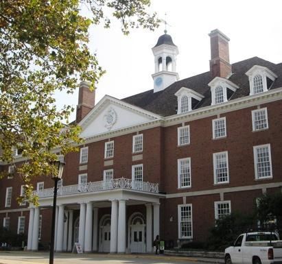
OUR HOME AWAY FROM HOME
                      The Natural History Building
                                        The newly renovated Natural History
                                        Building has served as the conference
                                        venue since 2017. This 148,000 square-foot
                                        space features a 300-person auditorium,
                                        modular classrooms and laboratories
                                        employed with the latest technology suitable
                                        for collaboration among faculty and students.
                                        Our visualization studio allows researchers
                                        to analyze satellite weather data and allows
                                        students to practice broadcast meteorology.
We wish you could join us in person to check out our great facility! Hopefully the
pandemic will end soon and we can welcome you to campus!

                                   The Union
                      The Illini Union, located on the north side of the Main Quad,
                      serves as a hub where students can eat and relax. The bottom
                      floor features many restaurants as well as an arcade and a
                      bowling alley. The Illini Union Hotel is situated on the top levels
                      of the building, making it a convenient location for conference
                      attendees in past years from out of town to enjoy the campus
                      environment.

                                       The FARM
                       The Flexible Array of Radars and Mesonets (FARM) consists of
                       DOW radars, mobile mesonets, mobile upper air sounding
                       systems, disdrometers, and deployable instrumentation pods
                       used to service the scientific community. The DOW radars have
                       been used in numerous field campaigns including VORTEX2,
                       PECAN, OLYMPEX, SNOWIE, RELAMPAGO, VORTEX-SE,
                       and more! We are really excited to have this facility on campus!

Follow us on Twitter @MSCAR_Illinois
Like us on Facebook at Midwest Student Conference on Atmospheric Research –
MSCAR

                                          2
KEYNOTE SPEAKERS
                                     Dr. Marshall Shepherd is the Georgia Athletic Association
                                     Distinguished Professor of Geography and Atmospheric
                                     Sciences at the University of Georgia and Director of its
                                     Atmospheric Sciences Program. Dr. Shepherd was the 2013
                                     President of American Meteorological Society (AMS). Prior to
                                     academia, he spent 12 years as a scientist at NASA Goddard
                                     Space Flight Center and was Deputy Project Scientist of the
                                     Global Precipitation Measurement Mission. Dr. Shepherd is
                                     the host of The Weather Channel’s Weather Geeks Podcast
                                     and a senior contributor to Forbes Magazine. In 2021, Dr.
                                     Shepherd was elected to the National Academy of Sciences,
                                     National Academy of Engineering, and the American Academy
                                     of Arts and Sciences. The only member of the University of
                                     Georgia faculty to ever achieve this trifecta. He has received
numerous awards including the 2004 White House PECASE Award, the Captain Planet Foundation
Protector of the Earth Award, the 2019 AGU Climate Communication Prize, the 2020 Mani L.
Bhaumik Award for Public Engagement with Science and the 2018 AMS Helmut Landsberg Award.
He received his B.S., M.S. and PhD in meteorology from Florida State University. He has two TEDx
talks on climate science and communication that collectively exceed two million viewers. He is
routinely asked to brief the media, Congress, and the White House on weather-climate-science
related topics. Dr. Shepherd has almost 100 peer-reviewed publications on various topics.

                         Dr. Karen Kosiba is an Adjunct Research Professor at the University of
                         Illinois and currently manages the FARM facility. She has a B.S. in Physics
                         from Loyola University, an M.S. in Physics and an M.A.T in Teacher
                         Education from Miami University, and a Ph.D. in Atmospheric Science from
                         Purdue University. When she began college, she considered careers in
                         architecture, patent law, and veterinary medicine, but ultimately decided that
                         observational studies of severe weather combined all of her interests. Her
                         research mainly focuses on the kinematics and dynamics of severe
                         convective storms, characterizing the low-level wind structure in tornadoes,
                         and understanding the boundary layer winds and small-scale structures in
                         landfalling hurricanes. Key to her research is executing field projects to
collect data that can be analyzed to better understand and predict these hazardous weather events.
Additionally, she is passionate about science education, regularly participating in outreach activities
at schools, museums, and festivals, and online and through media interviews and consultations. A
strong believer in experiencing weather from the inside of a mobile weather radar, she has
participated as a radar operator, project scientist, and project leader in a multitude of field projects.

                                                    3
Dr. Mika Tosca is a climate scientist, a humanist, and an activist. She is an
Assistant Professor at the School of the Art Institute of Chicago and an
affiliate climate researcher at the Jet Propulsion Laboratory (JPL) in southern
California. Her current research and public outreach explores the synthesis
of art and climate science and posits that engaging with artists, designers,
and makers is instrumental to solving the climate crisis. Mika is a proud
transgender scientist (she/her pronouns) and a vocal advocate for the queer
and trans communities in Chicago and beyond. Dr. Tosca earned her Ph.D.
in Earth System Science at the University of California Irvine.

                           4
TECHNICAL WORKSHOPS
Analyzing Radar Data with PyART with Dr. Scott Collis
This workshop will cover introductory use of the Python Arm Radar Toolkit (PyART), a
Python package used to read, manipulate, apply algorithms, and write radar data. PyART
is an open source collaborative software environment that is used by many in the field.

About the presenter: Dr. Scott Collis is an atmospheric scientist and head of the Geospatial
Computing, Innovations, and Sensing (GCIS) department in the Environmental Science
Division at Argonne National Laboratory and a Senior Fellow at the Northwestern Argonne
Institute of Science and Engineering (NAISE). Scott’s research is at the intersection of data
informatics, atmospheric science, and radar meteorology.

Satellite Data Analysis with Margaret Mooney and Dr. Scott Lindstrom
This workshop will help you understand what the different channels on geostationary and
low-Earth-orbit satellites tell you, and what tools you can use to access the data and display
it for yourself!

About the presenters: Margaret Mooney is the Education and Public Outreach lead at
NOAA's Cooperative Institute for Meteorological Satellite Studies (CIMSS). As a former
National Weather Service meteorologist, Mooney has ample experience working with formal
and informal audiences, leveraging early career experience with a degree in public policy to
promote weather and climate education as avenues towards stewardship and sustainability.
Dr. Scott Lindstrom is a weather weenie who grew up in State College PA, so of course he
got a BS from Penn State, then went to the UW-Madison for graduate degrees. He has
spent much of the past 20 years advocating for the use of satellite data in forecast
decision-making, and in that role has created and presented training to forecasters.

Implications of Climate Change with Dr. Trent Ford
This workshop will walk you through the recent release of the Intergovernmental Panel on
Climate Change as well as the Illinois assessment on Climate Change and talk about what
the specific climate implications are on the Midwest. Dr. Ford will also go over various types
of climate data, where they come from, as well as advantages and disadvantages to using
different datasets.

About the presenters: Dr. Trent Ford has been the Illinois State Climatologist since 2019.
He and his team provide/share climate data/information online, through traditional media
sources and social media, and speak to interested groups across the state. In addition to
his role in education and climate outreach, Dr. Ford also conducts research on the climate
change system and extreme climate events such as drought and heat waves.

                                              5
Meet our Careers Panel

                       Max Grover
   Max is a software engineer/data scientist within the
   Climate and Global Dynamics Lab at NCAR. He has
   a B.S. in meteorology from Valparaiso University and
   an M.S. in Atmospheric Sciences from the University
   of Illinois.

                       Evan Duffey
   Evan is a Senior Meteorologist and Manager of
   Forecasting and Operations at Pacific Gas and
   Electric Company in Dublin, California. He earned
   his B.S. in meteorology from SUNY Oswego in 2011
   where he worked with DOW data to investigate the
   structure of Lake Effect Snow Bands. He forecasts
   for the California electrical and gas grids as well as
   for fire weather.

                    Lisa Michaels
Lisa was born and raised in the northern suburbs of
Chicago. She earned her B.S. in Atmospheric Sciences
form the University of Illinois During her studies in
Champaign she spent one month storm chasing and
was able to see over 20 tornadoes, hail events, and
other weather phenomena. Lisa is a broadcast
meteorologist and has worked for NBC, ABC, CBS and
Fox affiliates.

                 6
Dr. Owen Doherty

Dr. Doherty is a climate and data analyst at Eagle Rock
Analytics. Dr. Doherty received his B.S. degree from Cornell
University in 2003 and his doctorate in Marine and
Atmospheric Sciences from Stony Brook University in 2012.
Eagle Rock Analytics is based out of Sacramento, CA and
the company focuses on answering data driven atmospheric,
climate, oceanic, and environmental science questions.

              7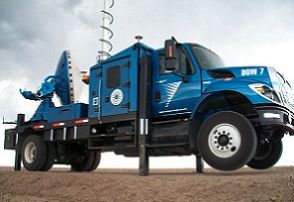
Graduate School Fair Participants

             School                 Point of Contact            Email
    Northern Illinois University      Victor Gensini       vgensini@niu.edu
University of Wisconsin-Milwaukee      Clark Evans        evans36@uwm.edu
          UCAR/NCAR                    Max Grover         mgrover@ucar.edu
     University of Minnesota           Dylan Millet         dbm@umn.edu
        Purdue University           Alexandria Johnson   avjohns@purdue.edu
       University of Kansas           Justin Stachnik      stachnik@ku.edu
        University of Iowa              Jun Wang         jun-wang-1@uiowa.edu
       University of Illinois          Ryan Sriver
       Urbana-Champaign                                   rsriver@illinois.edu

                                          8
OUR DEPARTMENT HEAD

                               Robert Trapp is the Department Head of the Department
                               of Atmospheric Sciences and a Blue Waters Professor at
                               the University of Illinois at Urbana-Champaign. Before
                               joining Illinois in 2014, he was a Professor in the
                               Department of Earth and Atmospheric Sciences at Purdue
                               University from 2003-2014 and a research scientist with
                               the National Severe Storms Laboratory (through the
                               Cooperative Institute for Mesoscale Meteorological
                               Studies) in Norman, Oklahoma from 1996-2013.
                               Professor Trapp is one of the lead authors of the 4th U.S.
                               National Climate Assessment Report from 2016-2017.

Dr. Trapp is the author of the book, “Mesoscale Convective Processes in the
Atmosphere”. He received his Ph.D. from the University of Oklahoma and was a
National Research Council Postdoctoral Fellow.

                            OUR FACULTY ADVISOR
                           Nicole Riemer is aProfessor in the Department of
                           Atmospheric Sciences at the University of Illinois at
                           Urbana-Champaign. Before joining Illinois in 2008, Dr. Riemer
                           was an Assistant Professor in the Institute for Terrestrial and
                           Planetary Atmospheres at Stony Brook University from
                           2005-08.

                           Dr. Riemer is a recipient of NSF-CAREER Award 2013 and
                           has been named a 2014-15 I. C. Gunsalus Scholar by the
                           College of Liberal Arts and Sciences at the University of
                           Illinois in recognition of her strong record of scholarship and
                           teaching in the physical and life sciences. She recently
                           received the 2021 AGU Ascent Award!

Additionally, Prof. Riemer is the faculty advisor and an integral part of the organizing
committee for MSCAR 2021!

                                             9
CONFERENCE SCHEDULE
(all times are in CDT)
Saturday, September 25th
Time Event
9:00-9:10 am Opening Remarks: Dr. Robert Trapp
9:10-9:55 am Keynote: Dr. Karen Kosiba
9:55-10:05 am Break
10:05-11:05 am Oral Session I: Winter Weather
11:05-11:15 am Break
11:15 am-12:30 pm Oral Session II: Severe Weather
12:30-1:00 pm Lunch Break
1:00-1:45 pm Careers in Earth Science Panel
1:45-2:30 pm Grad School Fair
2:30-2:45 pm Break
Oral Session III: Tropical Meteorology &
2:45-4:00 pm
_______________Atmospheric Winds
4:00-4:15 pm Break
Oral Session IV: Land Surface Interactions &
4:15-5:15 pm
_______________Pollution
5:15-6:30 pm Poster Session
6:30–7:00 pm Break
7:00-8:00 pm Keynote: Dr. Mika Tosca
8:00-9:00 pm Networking Event
Sunday, September 26th
Time Event
9:00-11:15 am Workshops
11:15-11:30 am Break
11:30am-12:30pm Keynote: Dr. Marshall Shepherd
12:30-1:00 pm Lunch break
1:00-1:30 pm DOW Tour and Q&A
1:30-2:00 pm Closing remarks & Awards
2:00-3:00 pm Networking EventORAL SESSION SCHEDULE
SESSION I: WINTER WEATHER (10:05 - 11:05 AM CT)
Time Name Talk Title
10:05-10:17 AM Andrew Janiszeski Kinematic Modeling Study of the Reorganization
of Snowfall beneath Cloud-Top Generating Cells
in Midlatitude Winter Storms
10:17-10:29 AM Divya Rea The Impact of Atmospheric Rivers on Cloud
Structure and Seedability during the SNOWIE
Experiment
10:29-10:41 AM
10:41-10:53 AM Yueqian Cao Topographic Controls on Hydrology and
Microwave Behavior of Seasonal Snowpacks:
Modeling Framework and Scaling Analysis
10:53-11:05 AM Kaylee Heimes The Impact of Fine Scale Updrafts and
Downdrafts on the Trajectories of Ice Particles
Created by Seeding Orographic Clouds in
Observed and Modeled Flow
SESSION II: SEVERE WEATHER (11:15 AM - 12:30 PM CT)
Time Name Talk Title
11:15 - 11:27 AM Bobby Saba Verification of Tornado Intensity Added to NWS
Preliminary Tornado Damage Path
11:27 - 11:39 AM Enoch Jo The Influence of Vertical Wind Shear on
Entrainment in a Simulated Supercell
Thunderstorm
11:39 - 11:51 AM Kevin Gray Investigation of Outflow Surge Characteristics in
Simulated Supercell Thunderstorms
11:51 AM - 12:03 PM Nathan Makowski Factors of Locally-Produced Thunderstorm
Genesis in the Southern Appalachians
12:03 - 12:15 PM Anthony Crespo Characterization of three hailstorms in Argentina
12:15 - 12:27 PM Devon Healey Comparing Polarimetric Signatures of Proximate
Tornadic and Non-Tornadic Supercells in Similar
Environments
12SESSION III: TROPICAL METEOROLOGY AND ATMOSPHERIC WINDS (2:45 - 4:00 PM
CT)
Time Name Talk Title
Investigating the dependence of hurricane intensity on
02:45 - 02:57 PM Chibueze Oguejiofor varying SST patterns using idealized model simulations
02:57 - 03:09 PM Cam My Nguyen A Multivariable Hurricane Hazard Index
Chandler Pruett and Weathering the Storm: How Cones of Uncertainty
03:09 - 03:21 PM Robert Szot Impact Hurricane Risk Perception
Downslope Wind Verification of the National Blend of
03:21 - 03:33 PM McKenzie Larson Models Across the Northern Front Range of Colorado
Forecasting Peak Wind Gusts for Specific Weather
Types Using the Meteorologically Stratified Gust Factor
03:33 - 03:45 PM Victoria Lang Model
Observed Land-Atmosphere Anomalies from ERA5
03:45 - 03:57 PM Sean Matus Associated with Extreme Great Plains Low-Level Jets
SESSION IV: LAND SURFACE INTERACTIONS AND POLLUTION (4:15 - 5:15 PM CT)
Time Name Talk Title
The influence of soil moisture anomalies on ENSO
04:15 - 04:27 PM Chu-Chun Chen teleconnections over southeastern South America
Orographic Rains at the Araripe Plateau - a Geostatistical
Victor Arraes Model for the climatic transition between the Cariri
04:27 - 04:39 PM Rocha Felix Cearense and the semiarid portion of Pernambuco
Modeling the real convective boundary layer in the ‘terra
04:39 - 04:51 PM Paolo Giani incognita’: different approaches to overcome the challenge
Influence of projected climate change, urban development
and heat adaptation strategies on end of twenty‑first century
04:51 - 05:03 PM Aldo Brandi urban boundary layers across the Conterminous US
Modeling analysis to advance understanding of air pollution
05:03 - 05:15 PM Beiming Tang in South Korea during KORUS-AQ
13POSTER SESSION SCHEDULE (5:15-6:30 PM)
Poster # Name Poster Title
1 The Evolution of CAPE, the Cold Pool, and Nocturnal Low-Level Jet
Alexander J and Their Impact on Surface-Based Vs Elevated Convection within a
Adams Simulated Severe PECAN MCS
2 Eshita Akter The Effects of changing climate on the stream flow of the Big Creek
Eva Lake Watershed in South Alabama
3 Hydroclimate variability of tropical South America during the last
Yuntao Bao deglaciation
4 Cody Barnhart Flash Floods: The Future of Baltimore City
5 Evaluating the effect of including additional soil layers in the Noah-MP
Carolina Bieri land surface model
6 Divyansh The Amazon and La Plata river basins as the Moisture Sources of
Chug South America: Climatology and Intra-seasonal Variability
7 Ian Cornejo The Role of Topography in a Heavy Rainfall Event in Taiwan
8 Rebekka Investigating UIUC Undergraduate Students' Knowledge of and
Delaney Responses to Severe Weather Events
9 Matthew Synoptic-Scale Predictors of Cool-Season Orographic Precipitation
DeMaria Gradients in the Contiguous Western US
10 Quantifying Land-Atmosphere Interactions in the Columbus, OH
Ruixuan Ding Metropolitan Area using Lightning Data
11 Alexander
Garber Tropical Cyclone Climatology for Tampa Bay, Florida
12 Lightning Characteristics of Thunderstorms over eastern India
Rakesh Ghosh (Nor'westers)
13 James Observational and Environmental Analysis of Tornadogenesis
Goodnight Mechanisms in Quasi-Linear Convective Systems
14 Spencer
Guerrero Investigating S2S Models of Atlantic Tropical Cyclone Landfalls
15 Kaylee A Long-Term Climatology of Favorable Synoptic Patterns for Severe
Heimes Storms
16 Analyzing Surface Precipitation Accumulations Upstream of the
Olympic Mountains using Observations and Simulations: An OLYMPEX
Scott James Case Study
17 Lillian Jones A scalable passive method for the quantification of airborne allergens
1418 Statistically bias-corrected and downscaled climate models
David Lafferty underestimate the adverse effects of extreme heat on U.S. maize yields
19 Generating CloudSat Reflectivity Using Passive Microwave Brightness
Daniel Lopez Temperatures and cGANs
20 Sophie Convective Windstorms in a Warmer Climate: A PGW Study Based on
Orendorf the 10 August 2020 Midwestern Derecho Event
21 Sreenath Scale resolved, sub-grid surface fluxes across a heterogeneous
Paler mid-latitude forested landscape
22 Michael A flood preparedness tool for the city of Chicago’s most vulnerable
Ragauskis communities
23 A Numerical Study Investigating Idealized Supercell Thunderstorms
Roger Riggin Interacting with the Appalachian Mountains
24 Michael Sessa The Prediction of Potential Tornado Intensity Using Machine Learning
25 Lydia Hail Nowcasting from Numerical Weather Prediction Model Data using
Spychalla Deep Learning
26 Madeline
Statkewicz Changes in Precipitation Patterns in Houston, Texas
27 Bringing water to the west: Microphysics and dynamics of orographic
Meghan Stell clouds influenced by atmospheric rivers
28 Hamid Ali Characterization of Hourly radar-based quantitative precipitation
Syed estimation
29 The Synergistic Role of Synoptic and Regional Processes for Drought
Seung Uk Kim Development in the Midwestern United States
30 Sarah Worden Where does moisture come from in the Congo Basin?
31 Establishing a Climatology of Significant Tornadoes within the Southern
Sean Whelan United States
32 Precipitation Growth Processes in the Comma Head Region of the 7
Troy Zaremba February 2020 Snowstorm observed during IMPACTS
15ORAL PRESENTATION ABSTRACTS
Andrew Janiszeski - University of Illinois
Kinematic Modeling Study of the Reorganization of Snowfall beneath cloud-top Generating Cells in
Midlatitude Winter Storms
Andrew Janiszeski - University of Illinois, Department of Atmospheric Sciences Robert M. Rauber -
University of Illinois, Department of Atmospheric Sciences B.F. Jewett - University of Illinois, Department
of Atmospheric Sciences G.M. McFarquhar - University of Oklahoma, CIMMS and School of Meteorology
While past research of mid latitude winter extratropical cyclones has investigated and observed
both near-surface precipitation banding features and cloud top generating cells within the comma head
region of such storms separately, little is known about the relationship between the two. The purpose of
this work is to determine the role of kinematics in the re-organization of ice particles beneath cloud top
generating cells into a low-level environment favorable for horizontal banded features using an idealized
kinematic model with a pure stretching deformation flow constant with height. The model used in this
study has a 500 x 200 x 10 km domain in X, Y, and Z respectively with 1 km grid spacing in both the
vertical and horizontal. Based on Keeler et al. (2017), particle clusters with increased particle
concentration representative of cloud top generating cells are arranged in rows angled 30 degrees
relative to the axis of dilatation, given a residence time in which they fall through the grid subject to the
deformation flow, and an initial spacing of either 5 or 15 km between cluster rows atop the grid. Various
sensitivity studies were conducted to determine change in shape of the initial snowfall distribution upon
reaching the surface with different deformation flow strengths, residence times, and initial spacings of the
generating cell cluster rows. Particle plumes subject to strong deformation of 2 10-4s-1 flow with
maximum residence time of 20,000 seconds, and minimum row spacing of 5 km exhibited a congealed
linear shape stretched along the axis of dilatation at the surface. Under weak deformation of 1 10-4s-1,
minimum residence time of 5,000 seconds, and maximum row spacing of 15 km, little change in the
shape of the initial distribution resulted. Stretching of the initial ice particle distribution for each experiment
was quantified using a ratio of length to width ratios (R) which was calculated by dividing length to width
ratio of the distribution at the bottom of the grid by the length to width ratio of the distribution atop the grid.
Stretching was greatest with strong deformation and maximum residence time with a R of 23.89/1 and
was least under weak deformation and minimum residence time with a R of 0.72/1. Another set of
experiments were run using a random arrangement of initial generating cell cluster positions also based
on Keeler et al. (2017). These experiments were run with the same residence times and deformation
strengths as the linear experiments and had similar results. The change in particle distribution shape and
amount of stretching demonstrates the role pure deformation plays in the horizontal organization and
distribution of snowfall beneath the generating cells. Future research will incorporate an upper-level jet
atop low-level front configuration in a mid-latitude cyclone environment where low-level band features
were present to conduct similar sensitivity studies.
16Divya Rea - University of Illinois
The Impact of Atmospheric Rivers on Cloud Structure and Seedability during the SNOWIE Experiment
Divya Rea - University of Illinois, Department of Atmospheric Sciences; Robert M. Rauber - University of
Illinois, Department of Atmospheric Sciences; Troy Zaremba - University of Illinois, Department of
Atmospheric Sciences; Huancui Hu - Pacific Northwest National Laboratory; Sarah A. Tessendorf -
National Center for Atmospheric Research
The Seeded and Natural Orographic Clouds: The Idaho Experiment (SNOWIE), which took place
from January - March of 2017, explored the impact of cloud seeding over the mountains. During the
campaign, the University of Wyoming King Air aircraft, equipped with the W-band Wyoming Cloud Radar
(WCR), flew across the Payette Basin of Idaho and seeded orographic clouds. Data collected via the
WCR revealed distinct, separated cloud layers during many intensive operation periods (IOPs).
Additionally, prior to many of the IOPs, an atmospheric river (AR) made landfall on the western coast of
the United States. In this study, water vapor from atmospheric rivers is tracked to examine the AR’s
influence on the moisture distribution in the Payette Basin during SNOWIE. One IOP which was preceded
by a strong AR is modeled using the Weather Research and Forecasting model (WRF) with added water
vapor tracers. The simulation begins well before the IOP, while the AR is located over the Pacific Ocean,
and water vapor from the AR is then tracked throughout the run. Output from WRF is compared to in situ
data, including data from the WCR, to quantify the AR’s contribution to the cloud field present at the time
of seeding. By tracking AR moisture both laterally and vertically, the AR’s impact on the split cloud layers
is also discussed.
17Yueqian Cao - Duke University
Topographic Controls on Hydrology and Microwave Behavior of Seasonal Snowpacks: Modeling
Framework and Scaling Analysis
Yueqian Cao - Duke University, Department of Civil & Environmental Engineering Ana P. Barros - University
of Illinois at UrbanaChampaign, Department of Civil & Environmental Engineering
Seasonal mountain snowpacks exhibit high spatial and temporal variability due to complex
topography, heterogeneous land cover, and weather patterns. A coupled distributed snow
hydrology-radiative transfer modeling framework, forced by high spatio-temporal reanalysis data (30-m,
15-min), was deployed over the Senator Beck Basin for the hydrologic year 2016-2017 to predict
topographic controls’ snowpack behavior in hydrology and microwave domain. The preprocessing of the
Sentinel-1 data found the localized attenuation patterns are associated with the basin slopes that can
alter the relative viewing angle of satellite and the local incidence angle of electromagnetic waves.
Therefore, a simple slope correction was conducted to elucidate topographic effects in the microwave
domain. The results show that the distributed modeling system can capture well topographic complexity
impacts on snowpack properties, and snowpack surficial melting after local noon enhances topographic
patterns in microwave regime and increases the retrieval’s ambiguity that is considerable at local 2 PM for
hysteresis phenomenon of the active and passive microwave signature. Besides, a large synthetic
ensemble experiment revealed that the uncertainties of snow-ground interface reflection introduce more
ambiguity than snowpack surface roughness. Based upon scaling analysis, the frequency-independent
multi-scaling behaviors illustrate the robust physical basis of simulated backscattering structures for dry
snowpacks, while brightness temperatures at 13.5 GHz exhibit stronger sensitivity to spatial variability of
wet snowpacks. This study indicates the importance of adequately configuring local topography geometry
in forward modeling systems before developing a low-ambiguity synthetic active-passive multi-frequency
framework for snow properties retrieval.
18Kaylee Heimes - University of Illinois
The Impact of Fine Scale Updrafts and Downdrafts on the Trajectories of Ice Particles Created by
Seeding Orographic Clouds in Observed and Modeled Flow
Kaylee Heimes - University of Illinois Urbana-Champaign, Department of Atmospheric Sciences Troy J.
Zaremba - University of Illinois Urbana-Champaign, Department of Atmospheric Sciences Robert M.
Rauber - University of Illinois Urbana-Champaign, Department of Atmospheric Sciences Sarah A.
Tessendorf -NCAR, Research Applications Laboratory Lulin Xue - NCAR, Research Applications Laboratory
Kyoko Ikeda - NCCAR, Research Applications Laboratory Bart Geerts - University of Wyoming, Department
of Atmospheric Sciences Jefferey French - University of Wyoming, Department of Atmospheric Sciences
Katja Friedrich - University of Colorado Boulder, Department of Atmospheric and Oceanic Sciences Roy
Rasmussen - NCAR, Research Applications Laboratory Melvin L. Kunkel - Idaho Power Company,
Department of Resource Planning and Operations Derek R. Blestrud - Idaho Power Company, Department
of Resource Planning and Operations
The goal of the Seeded and Natural Orographic Wintertime clouds: the Idaho Experiment
(SNOWIE) project was to understand the natural dynamic and microphysical conditions within clouds over
the Payette mountains to improve cloud seeding. During SNOWIE the Wyoming Cloud Radar (WCR) was
flown on the University of Wyoming King Air (UWKA) and made measurements of vertical radial velocity
in cross sections across the Payette Mountains of Idaho. During SNOWIE, a second aircraft released
seeding lines at approximately the -12 C level normal to the direction of flight of the UWKA. A technique
was used to retrieve vertical motions and terminal velocity of particles from WCR Doppler radial velocity
measurements. Weather Research and Forecasting model simulations were used as guidance for
targeting seeding. The 900 m resolution simulations adequately resolve vertical wave motions induced by
flow over the topography, but were unable to resolve finer scale circulations associated with other
phenomena. These measurements show two main categories of updraft structures including fixed,
orographic vertical circulations and transient structures including generating cells, gravity waves,
boundary layer and shear generated turbulence, and elevated, surface based, and boundary layer
convection. Flight legs were categorized into predominantly fixed, orographic or transient vertical
circulations using an index that quantifies the percentage of time that updrafts and downdrafts are over
upward sloping and downward sloping terrain, respectively. In this study, we examine the impact of
transient circulations on the trajectories of ice particles created by seeding. This was done to determine
whether simulating the finer scale circulations is necessary for accurate targeting of seeding effects, or
whether the 900 m simulations, which adequately resolve the primary orographically forced waves, is
sufficient for accurate targeting. Specifically, we compare results for 103 separate seeding lines,
quantitatively contrasting ice particle trajectories using vertical motions retrieved from radar and
generated by the 900 m simulations, using the same winds and terminal fall speeds in both cases so that
the only difference was the finescale updrafts present.
19Bobby Saba - Northern Vermont University - Lyndon
Verification of Tornado Intensity Added to NWS Preliminary Tornado Damage Paths
Bobby Saba - Northern Vermont University - Lyndon, Department of Atmospheric Sciences Christopher
Karstens - NOAA/NWS/SPC Bryan Smith - NOAA/NWS/SPC Rich Thompson - NOAA/NWS/SPC Andrew
Wade - CIMMS/SPC Patrick Marsh - NOAA/NWS/SPC Doug Speheger - NOAA/NWS WFO - Norman James
Ladue - NOAA/NWS/WDTD
This presentation will discuss the verification of a model created by the Storm Prediction Center
to diagnose the spatial intensity of tornadoes in near-real time. This model has the ability to add intensity
to the National Weather Service’s preliminary tornado damage paths to largely assist in emergency
manager decision making in affected areas. The model accomplishes this goal by filling the preliminary
damage polygon using a combination of WSR 88-D radar-derived rotational velocity, significant tornado
parameter (STP) derived from SPC mesoanalysis, 1-km resolution population from the 2010 census, and
output from an analytical vortex model. Verification is done by comparing model output data over several
Gaussian smoothing levels and 101 percentiles with the observational data from the Damage
Assessment Toolkit. Nine tornado tracks were compared ranging in both location and intensity. Cases
were chosen based on intensity and/or societal impacts. Comparing observation to model output,
forecast metrics were calculated, including probability of detection, success rate, false alarm rate, and
critical success index. Using these metrics, secondary stats such as absolute error, ROC scores, and
forecast climatology were also used to verify forecasts. Performance, reliability, and ROC curve diagrams
were created for each intensity level and case. Data from all 9 cases were averaged to conclude which
percentile and smoothing setting performed best overall. Preliminary results suggest that there may be
multiple smoothing setting and percentile combinations that yield the best results based on a user's value
proposition.
20Enoch Jo - University of Illinois
The Influence of Vertical Wind Shear on Entrainment in a Simulated Supercell Thunderstorm
Enoch Jo - University of Illinois, Department of Atmospheric Sciences Sonia Lasher-Trapp -
University of Illinois, Department of Atmospheric Sciences
The current study examines various mechanisms of entrainment in the mature stage of multiple
idealized supercell thunderstorms growing in the same thermodynamic environment but with varying
unidirectional or quarter-circle hodographs. Overturning “ribbons” of horizontal vorticity wrapping around
the supercell updraft that ascend in time are found to contribute more to entrainment with increasing
vertical wind shear, while turbulent eddies on the opposite side of the updraft contribute less with
increasing vertical wind shear. The storm-relative airstream, making up part of what is commonly called
the “storm inflow”, also introduces more low-level air into the storm core with increasing vertical wind
shear, as a result of increased storm translation speeds. The impact of the total entrainment on
precipitation production within the storm core decreases with increasing vertical wind shear, consistent
with previous studies that noted decreasing fractional entrainment with increasing core cross sectional
area. Thus, within the storm core, the precipitation efficiency increases with increasing vertical wind
shear. Despite the decreasing impact of entrainment and associated dilution with increasing
environmental shear in the storm core, the precipitation efficiency as gauged by the surface rainfall of the
storms decreases, as suggested in past studies.
21Kevin Gray - University of Illinois
Investigation of Outflow Surge Characteristics in Simulated Supercell Thunderstorms
Kevin Gray - University of Illinois; Jeffrey Frame - University of Illinois
Despite an increased understanding of environments favorable for tornadic supercells, it is still
sometimes unknown why some supercells are longer lived than others in similar environments. Our
previous work found that the midlevel shear vector orientation dictates where the 1-3 km precipitation
loading is maximized in simulated supercells, and thus can influence the updraft-relative location of
outflow surges. Backing of the 3-6 km shear vector results in outflow surge locations more favorable for
longer-lived supercells. We bolster this conclusion by investigating the duration, thermodynamics, and
origin height of the outflow surges, all of which do not impact supercell longevity in our simulations. The
location of outflow surges, however, greatly modulates convergence beneath updrafts, with a backed
midlevel shear vector leading to greater convergence. Outflow surge air is characterized by large values of
streamwise vorticity and we use vorticity budgets along trajectories to determine the processes
responsible for these large values.
22Nathan Makowski - Central Michigan University
Factors of Locally-Produced Thunderstorm Genesis in the Southern Appalachians
Nathan Makowski - Central Michigan University
Kyle Peco - University of Miami
Rain gauge observations in the Pigeon River Basin, NC, extracted for the months of July and
August over a twelve year study period (2009-2020), were classified into two types of warm-season
precipitation events, locally-produced and advected. Air-mass and multi-cell thunderstorms were
considered “locally-produced” if convection was forcibly initiated through contact with the southern
Appalachian Mountains located within Great Smoky Mountains National Park (GSMNP). Observation of
weak winds aloft without the influence of frontal passage or any tropical disturbance provided further
evidence of an event’s locally-produced nature within the region of interest. On the contrary, rainfall events
deemed “advected” were those with a convective origin outside of the southern Appalachians that were
able to quickly move across the Pigeon River Basin. The influence of approaching mid-level shortwaves,
outflow boundaries associated with incoming cold fronts, and tropical cyclone activity reinforced an
event’s advected classification. Through the separation of these events into two categories, it was
hypothesized that rising daily minimum temperatures have an effect on when locally produced
thunderstorm genesis occurs as a result of diurnal surface heating at higher elevations. Preliminary
results showed a correlation between locally produced case count for a given month, the existing average
monthly minimum temperature, and the average convective initiation time. The summers of 2013 and
2014, in particular, revealed an exceptionally low count of locally-produced cases, later daytime
thunderstorm formation, and a colder-than-normal average minimum temperature for both July and
August. This relationship was also tied to the east and westward movement of the North Atlantic
Subtropical High (NASH), a semi-permanent high-pressure system, which will be further analyzed. As
more data emerges regarding the changing climatology of the Pigeon River Basin, this study will continue
to examine the connection between warming minimum temperatures of the region and the onset of
thunderstorm formation. These results aim to provide insight into the impacts that climate change is
having on rainfall variability in mountainous regions and the underlying hazards these changes pose to
local communities.
23Anthony Crespo - University of Wisconsin-Madison
Characterization of three hailstorms in Argentina
Anthony Crespo - University of Wisconsin, Madison, Department of Atmospheric and Oceanic Sciences
Angela Rowe - University of Wisconsin, Madison, Department of Atmospheric and Oceanic Sciences Lucia
E. Arena - Universidad Nacional de Cordoba, Cordoba, Argentina, FAMAF
Falling hailstones are some of the most destructive natural phenomena in convectively active
regions of the world. Cordoba Province in Argentina is a region of severe storms of worldwide relevance
for being a hotspot for deep hail-producing storms. Previous studies of hail formation and detection
largely rely on satellite snapshots or modeling studies, but lack hail validation, instead relying on proxy
metrics. Here, to address this limitation, we collected hail in the Cordoba region, including from a
record-breaking hail event and from the 2018-19 RELAMPAGO field campaign. Using data from the C-band
Córdoba operational radar and GOES-16, we analyzed three cases that have verified hail and include
different storm types in different locations relative to the Sierras de Cordoba mountains. Brightness
temperature analysis show a gradual decrease over time, indicating vertical development in all cases,
even though not all cases reached the same minimum temperature prior to the hail reports. Other
satellite-based products show that all our cases show a weakening of the updraft before the hail report
and all are composed of ice crystals with smaller ice crystal sizes inferred just prior to the hail report. Our
RELAMPAGO hail case was consistent with previous satellite-based studies that inferred hail in MCSs
over the Sierras de Cordoba during the late evening/early morning. Our two other hail-producing cases
occurred with large-scale ingredients that differed from the RELAMPAGO case. The results from this
comparison between three hail-producing cases gives us the motivation to look further at these different
types of environments favoring hail in this region and shows promise in using satellite proxies for hail
detection. Ultimately, the long-term goal is to better understand hail-producing storms and unique
challenges of forecasting hail in this region, especially given that these hail-producing systems formed in
different environments and were not well forecasted.
24Devon Healey - University of Nebraska-Lincoln
Comparing Polarimetric Signatures of Proximate Tornadic and Non-Tornadic Supercells in Similar
Environments
Devon Healey - University of Nebraska, Lincoln, Department of Earth and Atmospheric Sciences Matthew
Van Den Broeke - University of Nebraska, Lincoln, Department of Earth and Atmospheric Sciences
While much research has identified distinguishing environmental characteristics for tornadic and
non-tornadic supercell occurrence, it is possible for tornadic and non-tornadic supercells to coexist in
seemingly similar environments. In such situations, other factors such as storm interactions,
microphysical processes, and environmental heterogeneities smaller than the observational or model
gridscale likely influence whether a given supercell will become tornadic. Employing dual-polarization
radar in these scenarios can allow for inferences about microphysical processes and storm structures
that may differ between proximate tornadic and non-tornadic supercells. Results may support additional
methods to anticipate which supercell in a group of supercells is most likely to become tornadic from a
radar perspective. In this study, comparisons of polarimetric signatures between ~60 pairs of proximate
tornadic and non-tornadic supercells are presented. Environmental similarity between proximate
supercells is quantified and used to confirm that these supercells exhibited reasonably similar
environmental characteristics in their inflow regions. An automated algorithm for detecting and
quantifying polarimetric signatures in supercells is employed to perform comparisons between the
polarimetric signatures of these storms. We hypothesize that within a group of proximate supercells,
supercells that become tornadic will have larger ZDR columns and ZDR arcs, and stronger mesocyclones.
Mesocyclone strength is quantified through estimates of maximum low-level normalized rotation (NROT)
values. It is further hypothesized that non-tornadic supercells will have larger and more steady hailfall
regions throughout their lifetime.
25Chibueze Ogujiofor - University of Notre Dame
Investigating the dependence of hurricane intensity on varying SST patterns using idealized model
simulations
Chibueze Oguejiofor - University of Notre Dame, Department of Civil and Environmental Engineering and
Earth Sciences. David Richter - University of Notre Dame, Department of Civil and Environmental
Engineering and Earth Sciences. Charlotte Wainwright - University of Notre Dame, Department of Civil and
Environmental Engineering and Earth Sciences.
The rapid intensification of hurricanes remains a challenge in the broader context of hurricane
prediction, despite decades of research. This is largely due to the multiscale nature of hurricane dynamics
- ranging from large-scale environmental factors modulating hurricane evolution (e.g., sea surface
temperature) down to the proper representation of small-scale dynamics (e.g., boundary-layer dynamics).
Several studies have investigated the development and persistence of SST anomalies such as cold pools
in the wake of hurricanes, and how these affect the intensification of subsequent storms. Ocean
observation shows that the size, magnitude and lifetime of SST anomalies associated with cold pools
play important roles in hurricane dynamics and development. In this study, a geostatistical approach is
utilized to understand the impact of the length scale of these SST anomalies on storm intensity using
gaussian random fields. Sea surface temperature (SST) fields obtained from a combination of
observational data (ARGO and ALAMO float program) as well as high-resolution model output from ONR’s
COAMPS-TC code, provide spatial estimates of the SST fields under typical hurricanes. Experimental
variograms of these fields are used to generate multiple realizations of both conditional and
unconditional gaussian random fields with varying length scale parameters. The generated SST fields are
used as boundary conditions for idealized model runs using the CM1 code. We investigate the impact of
varying the SST length scale on subsequent hurricane dynamics, development, and intensification.
26Cam My Nguyen - University of Georgia
A Multivariable Hurricane Hazard Index
Cam My Nguyen - University of Georgia, Department of Atmospheric Sciences Derek Dyal - University of
Georgia, Department of Statistics Gregory Ellison - University of Georgia, Department of Statistics BeiBei
Xu - University of Georgia, Department of Statistics Tyler Harrington - University of Massachusetts,
Department of Environmental, Earth and Atmospheric Sciences Lynne Seymour - Associate Professor,
University of Georgia, Department of Statistics Andrew Grundstein - Professor, University of Georgia,
Department of Atmospheric Sciences
Hurricanes are destructive weather hazards that cause tremendous damages and deaths each
year. As of 2020, hurricanes have caused the U.S. a combined $95-billion in damage, resulting in the
deaths of 262 people. While there are no preventative measures to stop a hurricane from hitting a coastal
area, there are ways to help prepare for one. With NOAA’s Climate Prediction Center forecasting another
above-normal Atlantic hurricane season, it is of utmost importance for everyone to have a better
understanding of hurricane hazards so more informed decisions can be made. Currently, the
Saffir-Simpson Scale (SS scale) is used to classify hurricanes. This scale focuses on maximum sustained
wind speeds but does not quantify other associated hazards such as the size of the storm, possible
damage from storm surge, or potential for flooding from heavy rain. Additionally, other research has
highlighted the importance of minimum sea-level pressure to be used as a way to quantify a hurricane’s
damage. At the moment, there is no available visual graphic that incorporates various risk hazards and
can effectively communicate information. Therefore, we propose to develop a visual graphic that will
quantify the differing hurricane hazards in a way that can provide key information to varying stakeholders
like emergency managers, residents, local, state, and federal officials. Our approach is to statistically
compute the scale of four hazards (e.g. storm surge, wind speeds, tornadoes, and rainfall/flooding)
relative to other storms so that a comparison can be made and visualized. We drew from a plethora of
existing databases (e.g SURGEDAT, HURDAT, etc.) to build our climatological reference dataset, and we
selected five case studies of major storms of varying categories to highlight how this approach can
emphasize certain characteristics that could be of most concern to a particular group. We hope that the
ability to visualize the relative strength of different hazards within the hurricane can be used in planning
and response.
27Chandler Pruett and Robert Szot - Florida State University
Weathering the Storm: How Cones of Uncertainty Impact Hurricane Risk Perception
Chandler Pruett - Florida State University, Department of Earth, Oceanic, and Atmospheric Sciences
Robert Szot - Florida State University, Department of Earth, Oceanic, and Atmospheric Sciences
The Cone of Uncertainty (COU) is a graphic designed by the National Hurricane Center that
communicates the forecast track of the center of tropical systems. The COU graphic primarily distills a
forecast and its uncertainty to a single image, making redistribution of the NHC’s forecast highly available
to the general public. However, previous research suggests the public is confused by the COU and
desires to know a storm’s hazards in addition to its track. To probe this question, this study conducted an
extensive survey during the summer of 2021 to understand how the public perceives the current COU and
what modifications they may desire to facilitate storm preparations. Specifically, the research team
designed ten graphics -- the current COU with and without the track line plus eight modifications -- based
on a literature review and original concepts. These illustrations were shown to 149 in-person respondents
throughout the state of Florida and 4,181 online respondents throughout the United States. By
recognizing how the general public understands the current COU and potential modifications to the
graphic, this study investigated if a COU redesign was necessary and what modifications would need to
be included in such a redesign. Our finding is that survey respondents preferred a COU that includes
threat level at landfall.
28McKenzie Larson - University of Colorado-Boulder
Downslope Wind Verification of the National Blend of Models Across the Northern Front Range of
Colorado
McKenzie Larson - University of Colorado Boulder, Department of Atmospheric and Oceanic Sciences
Paul T. Schlatter - National Weather Service, Boulder, Colorado
Downslope windstorms are common across the High Plains of Colorado in the lee of the Rocky
Mountains and are capable of causing damage to property and significantly disrupting travel. This region
is renowned for two primary types of high downslope winds: (1) Chinook events that bring warm, dry, and
strong winds which are often associated with the development of mountain waves and (2) Boras are
colder and often associated with the passage of a mid- and upper-level trough. The National Blend of
Models (NBM) is regularly utilized by the forecasters at the Boulder Weather Forecast Office (WFO) and
has been known to underestimate winds, but until now, no study has looked in detail at how it performs
with downslope windstorms. In this study, downslope windstorms from October 2020 through May 2021
were identified using ten high-quality observation sites along the Front Range. The quantification and
analysis of the multiplicative biases, mean absolute errors (MAE), and timing errors of the wind speeds
and gusts for each event provide a better understanding of the NBM magnitude and timing errors. On
average, we see that the magnitudes of the wind speeds and gusts are approximately 35% and 33% too
low in the NBM output, respectively. Ultimately, these NBM verification statistics and analysis can be
implemented by forecasters at the NWS WFO Boulder and surrounding offices to improve wind forecasts
and warnings for these high-impact events.
29Victoria Lang - University of Wisconsin-Milwaukee
Forecasting Peak Wind Gusts for Specific Weather Types Using the Meteorologically Stratified Gust
Factor Model
Victoria Lang-University of Wisconsin-Milwaukee Teresa Turner-University of Wisconsin-Milwaukee
Brandon Selbig-University of Wisconsin-Milwaukee Austin Harris-University of Wisconsin-Milwaukee
Jonathan Kahl -University of Wisconsin-Milwaukee
Wind gusts present challenges to operational meteorologists, both to forecast accurately and
also to verify. Strong wind gusts can cause structural damage and present risks for energy generation,
among other hazards. Previous research has demonstrated skill in forecasting peak wind gusts using
meteorologically stratified gust factors (MSGF). The MSGF model incorporates site-specific gust factors
(ratio of peak wind gust to mean wind speed), stratified by different wind speed and direction
combinations. Peak gust forecasts are prepared by simply multiplying the appropriate gust factor by a
wind speed forecast, typically provided by model output statistics (MOS). This study seeks to further
investigate skill of the MSGF model when applied to seven gust-producing weather conditions.
Forecasted peak wind gusts were calculated and verified for specific weather conditions over 8 years at
sixteen sites across the United States. Results show that perfect prog forecast errors are quite small for a
majority of the weather types, with mean absolute errors (MAE) of only 1-2kts. This indicates that the
MSGF model provides an accurate representation of peak wind gusts when coupled with “perfect” wind
forecasts. When coupled with actual MOS wind forecasts, the MSGF model exhibited statistically
significant skill for 24-hour projected forecasts at all sites studied, for most weather types. The smallest
MAEs in peak gust prediction were observed for weather types of ‘night clear’, ‘night overcast’, and ‘high
pressure’, with MAEs of 2—4 kt. For most weather types studied the MSGF model was skillful in predicting
peak gusts at forecast projections from 6-24 hours, and in some cases from 6-72 hours. The model
performed less well for convective weather types. From the data evaluated it could not be determined
whether the GFS or NAM MOS product, when coupled with the MSGF model, was more skillful at
forecasting peak gusts.
30Sean Matus - University of Illinois
Observed Land-Atmosphere Anomalies from ERA5 Associated with Extreme Great Plains Low-Level Jets
Sean Matus - University of Illinois, Department of Civil and Environmental Engineering Francina
Dominguez - University of Illinois, Department of Atmospheric Sciences Praveen Kumar - University of
Illinois, Department of Civil and Environmental Engineering Trent Ford - University of Illinois, Illinois State
Water Survey
The U.S. Great Plains (GP) has a nearly $100 billion agriculture and livestock industry which is
vulnerable to drought and flooding events. The warm season in this region is frequently characterized by a
nocturnal low-level jet (LLJ). LLJs are defined broadly as confined wind corridors found in the lower
atmosphere and act as a major mechanism of atmospheric moisture transport. Previous studies have
shown that GPLLJs are driven by an interplay of synoptic atmospheric forcing and local land surface
forcing. Due to its nocturnal nature, GPLLJ generation mechanisms are usually studied at the diurnal
scale. We hypothesize that, due to the memory of the land surface, there could be land surface variability
at longer timescales that also modulate the intensity of a GPLLJ event. This work identifies extreme
GPLLJ events from ERA5 wind data using a peaks-over-threshold approach and classifies them by
geographic region and synoptic state. Daily anomaly composites of land surface variables, including
root-zone soil moisture and 2m temperature, show an anomalously dry, warm region building in the days
leading up to an extreme GPLLJ event. Additionally, the location of the antecedent anomalies
corresponds with the eventual entrance region of the GPLLJ event. As such, there is predictive value in
continuing to unravel the role of the land surface in modulating the GPLLJ, and subsequent precipitation,
to motivate improved system resiliency.
31Chu-Chun - University of Illinois
The influence of soil moisture anomalies on ENSO teleconnections over southeastern South America
Chu-Chun Chen - University of Illinois, Department of Atmospheric Sciences Francina Dominguez -
University of Illinois, Department of Atmospheric Sciences
The objective of this study is to evaluate the interactions between soil moisture anomalies and
the El Niño-southern oscillation (ENSO) teleconnections over southeastern South America. During the
austral summer, ENSO reaches its peak phase, and the anomalous convection over the tropical Pacific
influences the climate over South America through Rossby waves. ENSO is often associated with extreme
drought and flooding, leading to significant socio-economic impacts. On the other hand, the summer
season is also the peak for land-atmosphere interactions, especially over southeastern South America.
Dry soil moisture anomalies can influence the rainfall one or two months later through moisture recycling
or changes in atmospheric circulation. Both ENSO and soil moisture anomalies play essential roles in the
climate of this region; however, few studies have investigated their interaction and modulation.
Preliminary results using ECMWF Reanalysis v5 (ERA5) show that the antecedent dry soil moisture
anomalies over southeastern South America in December are associated with more precipitation over this
region in January. This negative feedback may weaken the precipitation response to La Niña events over
southeastern South America. To evaluate causality, we further conduct a control simulation and three
experimental simulations using the Community Earth System Model (CESM), prescribing: (1) ENSO sea
surface temperature (SST) anomalies, (2) dry soil moisture anomalies over southeastern South America,
and (3) both SST and dry soil moisture anomalies. Understanding the interactions between the effects of
ENSO and soil moisture anomalies can potentially improve forecasts on sub-seasonal to seasonal
timescales.
32You can also read