Baroque origins of the greenery of urban interiors in Lower Si- lesia and the border areas of the former Neumark and Lusatia
←
→
Page content transcription
If your browser does not render page correctly, please read the page content below
Preprints (www.preprints.org) | NOT PEER-REVIEWED | Posted: 25 January 2021

          Article

          Baroque origins of the greenery of urban interiors in Lower Si-
          lesia and the border areas of the former Neumark and Lusatia
          Bogna Ludwig 1*

                                       1*   Wroclaw University of Science and Technology, Wroclaw, Poland; bogna.ludwig@pwr.edu.pl

                                       Abstract: The article is the first attempt to gather information on the beginnings of using green
                                       elements in urban compositions in Lower Silesia and border areas, in the former Neumark and
                                       Lusatia. It presents Baroque urban arrangements with the use of green ground floors, tree espaliers
                                       and avenues, from the earliest ones – occurring in the aftermath of the Thirty Years’ War – and the
                                       solutions applied in private municipalities in the Habsburg, Wettin and Hohenzollern states, which
                                       were recovering from war damage, to urban developments at the end of that period, in the areas
                                       already under Prussian rule and its strict regulations. A comparison with the achievements of Eu-
                                       ropean urban planning in this field allows us to trace the paths of inspiration, but also to uncover
                                       some innovative achievements.

                                       Keywords: urban baroque greenery; 17th-18th century; allée; Lower Silesia; preservation and re-
                                       newal of heritage

                                       1. Introduction
                                             Although there were no large or dynamically developing urban centres in Lower
                                       Silesia during the Baroque period, there were changes in the appearance and design of
                                       architecture, which largely influenced the appearance of municipalities, changes which
                                       were based on a modern view of the relationship between public space and buildings.
                                       Greenery complexes were among the new components introduced to Baroque spatial
                                       arrangements of urban interiors. These urban planning activities have been rarely noticed
                                       by researchers, as a result of which no comprehensive scientific study has yet been de-
                                       voted to them yet.
                                             Greenery was only introduced into urban planning arrangements when the resi-
                                       dential municipalities, still autonomous of the Habsburg State, were transformed in the
                                       Duchies ruled by the Houses of Piast and Württemberg as well as in Albrecht von Wal-
                                       lenstein’s estates. The investments of Louise of Anhalt-Dessau (1631-1680), Christian Ul-
                                       rich Württemberg (1652-1704) and his wife Anna Elisabeth of Anhalt-Bernburg
                                       (1647-1680) were of particular importance. In the following period, new small private
                                       urban centres were established in which the owners of the border lands received reli-
                                       gious refugees from Silesia, Bohemia and Moravia; in such municipalities, tree avenues
                                       made up the centre or one of the most important elements of the composition. The initi-
                                       atives of Count Balthasar Erdmann von Promnitz (1656-1703), Konrad von Troschke
                                       (1671-1728), and then the extensive actions of Nikolaus Ludwig von Zinzendorf
                                       (1700-1760), resulted from economic reasons, but they also clearly had an ideological ba-
                                       sis. The last villages with Baroque layout and greenery compositions were created in the
                                       Prussian state after the borders had been shifted. At the same time, according to the new
                                       principles of fortification design, tree espaliers became a component of fortification sys-
                                       tems and also served to protect the roads, which contributed to their further dissemina-
                                       tion as a composition element in urban planning.

            © 2021 by the author(s). Distributed under a Creative Commons CC BY license.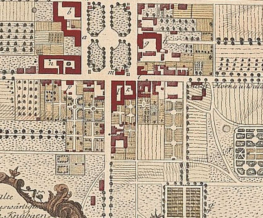
Preprints (www.preprints.org) | NOT PEER-REVIEWED | Posted: 25 January 2021

                                         The composition of greenery as a new urban solution was a trend that municipality
                                    owners took over from other regions of Europe. For this purpose, they hired suitable
                                    contractors. This phenomenon was clearly related to the descent and connections of ducal
                                    families in Lower Silesia. In the second period, the planning solutions were modelled
                                    primarily on those that were being developed in the immediate vicinity. Inspirations
                                    were also drawn during trips to remote European centres.

                                    2. Materials and Methods. State of the art and Sources
                                          Research on the history of greenery design in Europe [1] shows the genesis and
                                    dissemination of solutions from modern times for introducing greenery composition into
                                    urban interiors. In this respect, it is important to indicate why and how the ideas of de-
                                    signing greenery systems, initially only tree espaliers and avenues, used in gardens and
                                    open landscapes, were transferred to inner municipality structures. The juxtaposition of
                                    the emerging pan-European concepts in this respect allows us to refer to them realisa-
                                    tions from the presented region.
                                          Baroque urban planning in Lower Silesia and the border areas is a rarely studied
                                    issue. Therefore, it is difficult to expect researches on selected, quite detailed problems,
                                    such as the occurrence and the way of shaping greenery in public interiors. Studies of the
                                    historical spatial transformations of individual municipalities – from the oldest publica-
                                    tions from the turn of the 20th century [2,3] to contemporary ones [4–6] – reveal the
                                    characteristics and sometimes also the landscape role of Baroque transformations. These
                                    publications also include information on the introduction of greenery systems to urban
                                    design. However, the very phenomenon of the greenery of urban interiors occurring for
                                    the first time in the Baroque period has not been properly noticed. This issue is partially
                                    discussed in an article devoted to the history of gardens from that period, which were
                                    also used as types of parks established at the settlements of the Moravian brothers in
                                    Lusatia, Hessen and Lower Silesia [7]; yet, the aforementioned text does not characterise
                                    the phenomenon of urban interior design with greenery systems. Similarly, the book by
                                    the same authors mainly mentions the greenery of gardens and parks, not urban green-
                                    ery [8]. Historical research, in which the landscape role of the avenue is discussed, con-
                                    cern the later assumptions and usually palace-park complexes [9]. In recent years, there
                                    have been fairly extensive studies on the natural qualities of avenues, which is a com-
                                    pletely separate theme.
                                          The analysis of local sources makes it possible to trace when and in what forms the
                                    first elements of greenery that shape urban compositions in Lower Silesia and the border
                                    areas of the Neumark and Lusatia emerged. The most precise information on this subject
                                    is provided by iconographic representations, made shortly after their creation, such as
                                    drawings by F.B. Wernher [10–16]. Cartographic records coming only from the 19th
                                    century are a valuable supplement of information [17–22]. Notes from Baroque chronicles
                                    written by F. Lucae [23] and the already mentioned F.B. Wernher [11–13], as well as from
                                    18th and 19th century historical and topographical descriptions of Prussian Silesia by
                                    F.A. Zimermann [24] and, J.G. Meissner [25], as well as descriptions of the March of
                                    Brandenburg by F.W.A. Bratring [26] and Saxony by F.A. Schumann and A. Schiffner [27]
                                    are important sources of knowledge.
                                          From these juxtapositions one can read out what patterns and how quickly they
                                    were adopted in the discussed area, answer the question whether own solutions were
                                    developed and to what extent this new form of space arrangement using greenery com-
                                    position was widespread.

                                    3. Results and Discussion

                                    3.1. Avenues and tree espaliers – the beginnings of urban green space in European municipalities
Preprints (www.preprints.org) | NOT PEER-REVIEWED | Posted: 25 January 2021

                                          Since the end of the 17th century, trees have been consciously introduced as com-
                                    positional elements, first in the form of tree espaliers and then allées. In ducal munici-
                                    palities, the tree espaliers began to mark important spatial connections between the rul-
                                    er’s seat and the temple. Then they became widespread in the municipalities possessed
                                    by the landed aristocracy as well. The tree espaliers began to be used as a composition
                                    element during the Renaissance. Allées appeared in garden arrangements. Initially, the
                                    straight paths were covered with pergolas overgrown with vines to provide shade
                                    [A1][28]. Such solutions were already applied in the Middle Ages. The name espalier
                                    (Italian: spalliera) is derived from that period. Alberti in the Renaissance villa Quaracchi
                                    Giovani Ruccelai (1459) divided the grove – boschetto – with straight paths [29–30]. This
                                    method of design quickly spread in the sixteenth century and became the principle of
                                    shaping the gardens of the Italian country villas (Villa Medcici in Castello, in Pratolino,
                                    the Boboli Gardens by the Pitti Palace, the villa in Poggio a Caiano, Poggio Reale near
                                    Naples) and the gardens by the residences all over Western Europe, especially the hunt-
                                    ing parks (Blois, Gaillon, Hampton Court). It was also then that the term allée was in-
                                    troduced to name such paths [A2][31–32]. Wooden avenues were shaped outside the
                                    garden systems as paths leading to them (Chenoncaeux, Fointenbleau, Blois, Morien-
                                    mont, Aranjues) [1] (pp. 18-19). Palladio in his treatise recommended providing country
                                    roads with tree espaliers giving shade and constituting greenery as a respite for eyes
                                    [A3][33](pp. 262, 266). He also gave examples of the few such roads to Villa Cicogna and
                                    Villa Quinto in its area.
                                          At the same time, rows of trees planted over moats and canals began to become a
                                    decorative element of the municipality. At the end of the 16th century, Dutch municipal-
                                    ities such as Bruges, Gouda, Harlem, The Hague, Amersfoort and Kampen had wooded
                                    canal piers [34–37]. In The Hague, at the inner lake, Hofvijver, which was regulated by a
                                    rectangular basin, tree rows and greenery systems appeared as early as in the 14th cen-
                                    tury [38,39]. The wooded area of Lange Voorhout was incorporated into the municipality
                                    at the beginning of the 15th century. In 1536, during his visit, Emperor Charles V ordered
                                    the planting of an avenue of linden trees, which would connect the adjacent gardens in
                                    this area [40,42]. Trees were also planted in the 1670s around the fortifications in Ant-
                                    werp, and at the end of the 16th century also in Italian municipalities of Florence, Siena,
                                    Piacenza, Lucca and Padua. The enlargement of municipalities also boosted the appear-
                                    ance of groups of trees. In Amsterdam tree-lined canals were introduced in place of old
                                    fortifications after they had been shifted to a new line in 1585 and once again in 1610 [43].
                                    In Leiden such changes occurred slightly later, and in Utrecht in 1660 [1](pp. 44-45). In
                                    the 17th century, the custom became widespread and tree-lined canals were created in
                                    many Dutch municipalities.
                                          In accordance with Palladio’s recommendations, roadsides were lined with trees
                                    from the end of the 16th century. The suburban roads of Rome have mostly turned into
                                    avenues over several decades [44]. In France, already in 1553 and 1575, kings Henry II
                                    and Henry III ordered the royal roads to be tree-lined. However, it was only J.B. Colbert’s
                                    decree of the 1650s, which applied the 1601 Edict of Suleti, decided that this principle was
                                    fully implemented [1](p. 19) (which, for example, was clearly visible around Reims [46]).
                                    Outside Italy, roads leading to residences were also designed in the form of avenues. The
                                    earliest example of which is the tract to Hellbrunn from Salzburg, created in 1615-1619
                                    [47,48]. In the 17th and 18th century, avenues leading to palaces became the norm (e.g.
                                    from the more famous Fürstenallee in North Westphalia to the hunting lodge Oesterholz,
                                    1725, Poppelsdorferallee near Bonn to the palace of the same name, around 1730, Wil-
                                    helmshöher Allee in Kassel, from 1767, Laxenburger Allee, Schönbrunner Allee near
                                    Vienna, 1741).
                                          Social changes in big municipalities – the settlement of courtiers and nobles, as well
                                    as the growth of a rich patrician group – have changed the habits and the manner of
                                    having entertainment. Horsemanship, outdoor games, such as tennis, golf, various ball
                                    games, pall-mall (paille-maille), shooting galleries, required green areas. Suburban rec-
                                    reation areas began to emerge; in the Renaissance, suburban gardens (e.g. in the neigh-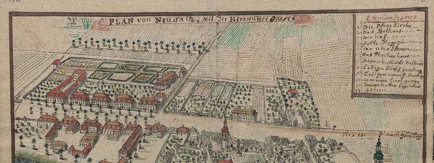
Preprints (www.preprints.org) | NOT PEER-REVIEWED | Posted: 25 January 2021

                                    bourhood of Florence, Rome, Naples, Paris, London, Bruges, Antwerp), in the Baroque
                                    replaced by promenades and suburban avenues and boulevards. Special areas for
                                    pall-mall appeared from the end of the 16th century in Paris, The Hague, Utrecht and
                                    London. Then they were often used as walking promenades and as such were copied in
                                    other municipalities in the 17th and 18th centuries. Riding avenues in Florence, the route
                                    over the Arn and the Course la Reine on the Seine, modelled on it in Paris (1616), inspired
                                    further routes in the vicinity of Marseille, Aix, but also outside France near Madrid or in
                                    London [1](pp. 32-37).
                                          The first urban interiors designed using tree espaliers of trees were also realised. In
                                    Aix en Provence, the square of the new district of Villeneuveve was lined with trees in
                                    1580. In Willemstadt and Klundert, the new fortress municipalities founded in the 1580s
                                    in North Brabant by Wilhelm of Orange, trees surrounded some squares and streets
                                    [1](pp. 22-26) [49,50]. Created in 1630, Covent Garden Piazza in expanding London gave
                                    rise to squares as centres of aristocratic districts – Lincolns Inn, Bloomsbury Square, St.
                                    James Sq. in 1650-1660 – which were initially only lined with by tree espaliers and lawns.
                                    Others appeared after the great municipality fire (1666) and became a model for other
                                    English municipalities; e.g. Warwick or Bristol. In the second half of the 17th century,
                                    walking avenues were also created in English municipalities; in London leading to the
                                    cathedral, in Bristol, Bath, Wells and many provincial centres [1](pp. 38-51). In Rome,
                                    from the beginning of the seventeenth century, elm tree avenues were introduced at the
                                    passageways connecting the basilicas of Santa Croce and San Giovanni and further on
                                    Santa Maria Maggiore, the Arch of Constantine with the church of San Gregorio al Celio,
                                    as well as at Campo Vaccine on the site of the cattle market at the Roman Forum recre-
                                    ating the Via Sacra between the arches of Titus and Sever [51][A4]. Within the precincts of
                                    Paris there were established the royal gardens of Thulleries (created from 1564) and
                                    Luxembourg (completed in 1612), in the vicinity of Place Royale (later Place des Vosges,
                                    also formed until 1612) along with the gardens of Palais Royal (in 1633), and then the
                                    boulevards created on the site of the fortifications (Les Grands Boulevards, 1668-1705).
                                    However, public greenery appeared inside the municipality sporadically, only in the
                                    form of the greenery of Vosges Square in 1680. Further expansion of the metropolis
                                    connected it with suburban green areas such as Les Invalides Square (1670-1676), Jardin
                                    des Plantes (1626, as a public garden since 1640) or the Champ de Mars (1751) [52]. The
                                    tree arrangements in the urban composition did not gain a significant share in the Ba-
                                    roque in France. Even in the second half of the 18th century, when e.g. the extension of
                                    Rouen was planned, the project made by M. le Crapentier (1758), which included ave-
                                    nues and squares surrounded by tree espaliers, was mostly not realised, some of the
                                    works started only at the very end of the 18th century. Similarly, two proposals for the
                                    extension of Lyon (1768 and 1769) containing similar concepts were rejected [1](p. 66).
                                          It was different in the expanded and established municipalities in Prussia and
                                    German countries, where Dutch examples of the use of tree espaliers but also French
                                    garden solutions were used in shaping urban layouts. The Hague Voorhout became an
                                    inspiration for an avenue, initially simply called Erste Straße, which was created on the
                                    initiative of the Great Elector Frederick William I in Berlin to be planted as early as 1647,
                                    according to the Dutch model, with lime trees (hence from 1734 called Unter den Linden)
                                    [53]. The avenues formed the urban backbone of the New Municipality in Dresden; first
                                    the main axis of the Hauptstrasse (1687) was formed and then extended along the
                                    Koenigsstrasse (1722-1732). In Frankfurt, in 1712 the main square of the New Municipal-
                                    ity – Rossmarkt – was on the order of the municipality council provided with greenery
                                    around the fountain and a chestnut allée extended therefrom along the frontage of new
                                    houses [54]. The greenery compositions had the greatest share in the planning of the new
                                    residential municipality of Charles III Wilhelm von Baden-Durlach – Karlsruhe in 1715,
                                    often regarded as a manifestation of Classicist urban planning. This architectural concept
                                    was based on a pattern of radial tracts spreading from the palace (or in fact the tower next
                                    to it), where the streets continued along the garden avenues. Similarly, one of the two
                                    axes shaping the composition of St. Petersburg (founded in 1703) – Nevsky Prospect –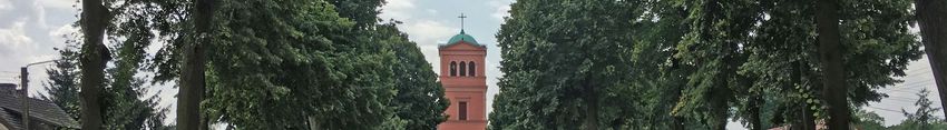
Preprints (www.preprints.org) | NOT PEER-REVIEWED | Posted: 25 January 2021

                                    featured tree espaliers [55]. The avenues also became the basis of the layout of munici-
                                    palities and districts for Huguenot refugees, as was the case Potsdam. Potsdam became a
                                    residential municipality from around 1675, intensively populated by Huguenots emi-
                                    grating from France after the Fontainebleau and Potsdam Edict from 1685. It developed
                                    along the allée stretching from the elector’s hunting lodge into an open area. The Hu-
                                    guenots’ refugee districts built near the capital municipalities of Erlangen, Kassel, Mag-
                                    deburg and Plön were similarly planned. For example, the new municipality in Erlangen,
                                    designed by Johann Moritz Richter, builder of margrave Christian Ernest Hohenzol-
                                    lern-Bayreuth (1686, 1706), together with the construction of the palace from 1700 on-
                                    wards, took on the layout of a municipality-residence with a palace-garden composition
                                    axis. The avenues also surrounded and connected new districts of a different character,
                                    such as the Herrenhauser – residential district of Hanover. Chestnut promenades con-
                                    nected the expanding Bayreuth (1725) and Ansbach (1737)[56,57]. Tree espaliers also
                                    began to be used to emphasise the representativeness of the site, as in Manheim around
                                    the monument on the Pardeplatz designed in 1712 (made in 1743) to commemorate the
                                    victory in the war of succession in the Palatinate (1688-1697).
                                         The problem of trees was treated somewhat differently by Frederick William I
                                    (1688-1740) and then Frederick II the Great (1712-1786), also taking into account their
                                    economic significance. It was recommended to plant fruit trees, mulberries for silkworm
                                    rearing and willows for wicker production. In time, state orders were issued, initially
                                    covering the protection of planting, and subsequently orders for the introduction of av-
                                    enues of trees [A5][58,59]. In 1742, the planting of fruit trees and mulberries was ordered,
                                    which also covered Silesia, conquered at that time [60–63].

                                    3.2. Greenery of urban ducal residences in Lower Silesia
                                          As in Western Europe, the initial introduction of greenery into municipalities in
                                    Lower Silesia was associated with the transformation of the ducal urban seats, while on
                                    their outskirts with the formation of links between municipalities and neighbouring and
                                    suburban palaces. In modern times, greenery compositions were gaining in importance
                                    in residential layouts, initially only for recreation and decoration, then also for composi-
                                    tion.
                                          The visual impact of residences on society began to become increasingly important
                                    in modern times. For this purpose, different means were made use of than those in the
                                    Middle Ages, where monumentality and inaccessibility were the dominant features of a
                                    ruler’s residence or a feudal lord. In modern concepts, the criterion of representativeness
                                    expressed through classical order architecture but also through the surrounding greenery
                                    came to the fore. In addition to the architectural changes in line with the current trends, it
                                    was the garden facilities that gave prestige to the ruler’s seat, as evidenced by the castle
                                    gardens in Brieg (currently Brzeg) and Glogau (Głogów). The Brieg castle was trans-
                                    formed and thoroughly rebuilt during the times of Duke Frederick II (1480-1547) and his
                                    son George II (1523-1586), and thus changed from a Gothic defence building into a mag-
                                    nificent Renaissance residence [23](pp. 1363-1364)[64](pp. 2-4)[65](pp. 25, 28-40)[66].
                                    From the foundation of George II and his wife in 1554-1560, a three-storey building of the
                                    entrance gate, the most important investment shaping the appearance of the castle from
                                    the municipality side and presenting a rich iconographic programme, was erected be-
                                    tween the south wing and St. Hedwig’s collegiate chapel [67]. At the same time, the col-
                                    legiate church was transformed into a mausoleum of dukes. Italian architects Jakob and
                                    Franziskus Pahr were employed in the reconstruction of the castle. The continuators were
                                    Bernard and Peter Niuron, who also fortified the residence at the end of the century. The
                                    surroundings were also changed to shape the castle’s representative gardens. To the
                                    north of the castle, an orchard was planted along the walls, which incorporated the for-
                                    mer Dominican monastery grounds, with a hill (Sperling Berg)[68](pp. 77-78) [A6]. On
                                    the east side, a garden (Lustgarten) was arranged in front of the windows, covered with a
                                    wall on the municipality side Figure 1. (a).
Preprints (www.preprints.org) | NOT PEER-REVIEWED | Posted: 25 January 2021

                                          Similar transformations were made in the Glogau castle. At the turn of the 15th and
                                    16th centuries, Glogau was inhabited by Prince John Albert, and then by Sigismund
                                    Jagiellon (both after Kings of Poland and Grand Dukes of Lithuania), who began re-
                                    building the castle, which had been ruined during the siege by Matthias Corvinus army.
                                    Gardens were then arranged next to the castle, while behind the bailey and the second
                                    line of moats and walls, an entrance square was created [69].
                                          In the Baroque era, residences and gardens began to be composed in a new way.
                                    Activities were undertaken both in the ducal residences and the former manors of the
                                    landed gentry which were rebuilt into palaces. In exceptional cases, they were matched
                                    with the municipality layout, as was the case in Juliusburg (Dobroszyce) or Festenberg
                                    (Twardogóra). After the Thirty Years’ War, not only different Baroque architectural and
                                    ornamental forms were used, but also the approach to space arrangement changed.
                                    Compositions with a dominant axis were introduced. In representative forms, the fore-
                                    ground of the residence was designed. Extensive garden arrangements with pavilions,
                                    orangeries and loggias were created.
                                          The first gardens of this type were established by the order of Louise of Anhalt in the
                                    1670s, in the Duchess’s seats in Brieg, Ohlau (Oława) and Wohlau (Wołów), which were
                                    being rebuilt at that time. As Lucae noted, these gardens were to provide a beautiful vista
                                    [23](p. 1374). In all castles, the Duchess introduced terraces and vista points to the
                                    greenery of the gardens. In Brieg and Wohlau it was probably mainly about views from
                                    the palace windows to the garden, but in Ohlau the front gardens also provided an at-
                                    tractive view of the new residence from the municipality side. The green areas thus be-
                                    came the backdrop for the ducal residence.
                                          In Brieg, the transformation of the residence began as early as during the times of
                                    Duke George III (1611-1664). In 1654, George took over the Brieg Duchy [70]. Already in
                                    1656 he started the reconstruction of the Renaissance castle in Brieg. One of the first in-
                                    vestments was to clean up the foreground on the municipality side. An openwork fence
                                    was erected to separate the courtyard and the castle garden from the municipality square
                                    (Topffmarkt), to which a gate with wickets, situated in front of the gate tower, led, which
                                    was shaped in the Palladian form, being a kind of triumphal arch [23](p. 1363)
                                    [11](pp. 297-301). On the western side, behind the fence, partly in front of St. Hedwig’s
                                    Castle Chapel, in 1658, there were farm buildings and a riding school, forge and stable,
                                    forming a screen around the castle. The front garden (Lustgarten) was redesigned. In the
                                    following year the castle façades and all towers were renovated after the Lions’ Tower,
                                    rebuilt in 1649, was destroyed by thunder. Already during the reign of the next Duke
                                    Christian, garden buildings were erected in the orchard; a loggia with an orangery, a
                                    birdhouse and a shooting range [A7] [8](pp. 156-157). The castle building was rebuilt to
                                    open from the east side to the garden with arcades [23](pp. 1364, 1367, 1378 1380)
                                    [64](pp. 23-25).
                                          Further Baroque changes were ordered in 1673 by Duchess Louise of Anhalt, widow
                                    of Duke Christian, George’s brother. The bay window on the eastern façade of the castle
                                    was then extended; it was crowned with a terrace and enlarged while its windows were
                                    made uniform, and a new arcade loggia was constructed on the municipality and garden
                                    side. In this way, the Brieg Castle received not only a representative entrance square on
                                    the municipality side and a decorative front garden but also a vantage point Figure 1. (b).
                                          As a regent, the Duchess held power in the Liegnitz-Brieg (Legnica-Brzeg) Duchy in
                                    1672-1675 because her son George IV William (1660-1675) was underage. After the death
                                    of George William, who reigned for only a few months, the duchy came under direct rule
                                    of the Habsburgs and the Duchess settled in Ohlau. The Brieg castle used by Austrian
                                    officials and visiting dignitaries was partially neglected [68](p. 82). The Jesuits soon lo-
                                    cated their seat next to it and occupied most of the former Dominican monastery
                                    grounds, which was to become the castle garden. In 1741 the Brieg residence was shelled
                                    and burnt down by the Prussian army. The façade of the entrance building and part of
                                    the ground floor of the eastern wing survived [64](pp. 16-17). It was rebuilt into an inn
                                    and warehouses (1743-1755), while its architectural form was no longer taken care of.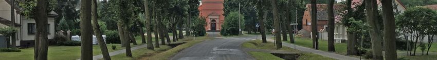
Preprints (www.preprints.org) | NOT PEER-REVIEWED | Posted: 25 January 2021

                               (a)                                                                (b)

            Figure 1. (a) The ducal residence in Brieg. A fragment of the Brieg plan, probably from the period between 1618 and 1633 71; (b)
                                      The ducal castle in Brieg around 1750 in a drawing by F.B. Wernher 11(p. 297).

                                                In the modestly presented urban development of Ohlau, the castle’s representative
                                          foreground was also taken care of. An original layout was created here, consistent with
                                          the municipality’s location plan, which included a Baroque urban interior combining two
                                          areas of urban and residential function. In 1654, after the death of Duke Georg Rudolf, the
                                          lands of the Duchy of Liegnitz were divided among the sons of his brother Johannes
                                          Christian, Duke of Brieg [70]. The youngest of them Christian (1618-1672) received
                                          Wohlau and Ohlau. He had Carlo Rossi from Como start the reconstruction of the di-
                                          lapidated Ohlau residence in 1659 by. The works under the direction of the Italian archi-
                                          tect lasted until 1680, well into the time of Louise of Anhalt [23](pp. 1405-1406), whom the
                                          emperor granted the Ohlau and Wohlau lands for life. At the same time, the castle
                                          changed the defensive system of the roundel into an earth bastion. Rossi modernised the
                                          residence itself [72](pp. 43-53)[73](p. 383). In the years 1659-1673, he erected or converted
                                          the former building, which was added to the residential section on the east side (now a
                                          church stands here), into a two-storey pavilion in early Baroque forms topped with a
                                          terrace with figures [11](p. 398-400). This part of the castle was henceforth called Chris-
                                          tianbau. From 1655 a chapel on the northern side of the courtyard began also to be rebuilt
                                          and a garden behind the palace. In the further 1673-1680 extension of the castle, a
                                          four-storey part called Duchess Louise’s palace (Louisenbau) was created, which opened
                                          from the courtyard with an arcade loggia, and was decorated with Baroque details on the
                                          front complete with a richly decorated portal depicting the Duchess’s coat of arms [23](p.
                                          1406). In front of the residence, the foreground was cleaned; the buildings were demol-
                                          ished, the bridge was moved, leaving the moat, the castle fortifications on the munici-
                                          pality side were removed, and a garden was established in their place. A decorative fence
                                          with stone posts along the palace façade was introduced, separating the green belt from
                                          the moat on both sides of the bridge Figure 2 [11](p. 267, 396-397, 400)[75] [A8] [76,77]. A
                                          drawbridge, preceded by stone pillars-pylons, leading to the main entrance portal to the
                                          inner courtyard of the mansion was built in the middle of it [A9]. The square’s composi-
                                          tional axis was arranged, directed at the portal on the palace’s façade, which was delib-
                                          erately moved from the building’s axis of symmetry to the east and emphasized by the
                                          use of double windows and the emerging castle tower behind it. This axis was marked
                                          out on the axis of the location municipality, i.e. in the middle of the market quarter facing
                                          the Castle Square Figure 3. Its continuation in the open landscape was the main avenue of
                                          gardens behind the moat and bastion fortifications, highlighted by a pavilion in the
                                          middle [11](p. 397)[23](p. 1402). In this way, a very coherent and homogeneous compo-
                                          sition of this urban layout was created, which obliterated the various origins of the ele-
Preprints (www.preprints.org) | NOT PEER-REVIEWED | Posted: 25 January 2021

                                    ments of the location municipality and the medieval castle being transformed into a
                                    palace.

                                    Figure 2. The southern elevation of Ohlau Castle on a drawing by F.B. Wernher from around 1730
                                    [11](p. 267).

                                    Figure 3. A view of castle buildings and gardens in a drawing from the times of James Louis
                                    Sobieski 78.

                                         In 1691, Prince James Louis Sobieski settled in the castle in Ohlau to live there for
                                    over forty years. After his 1734 move to Żółkiew, the building began to deteriorate. It was
                                    taken over by the imperial court after Sobieski’s death (1737) and became the residence of
                                    imperial administration officials. After Silesia had been incorporated into Prussia, a mil-
                                    itary lazaret was installed in the castle in 1744 and a field bakery in 1761. The moats were
                                    eliminated whereas the gardens were expanded. Rows of mulberry trees were planted.
                                    And from 1764, next to the royal office, there was a silk spinning mill in the castle. In the
                                    years 1833-1834 a part of the castle (Chrystianenbau) was demolished and a Catholic
                                    church designed by Karl Friedrich Schinkel was erected in this place; after a 1938 fire a
                                    modernist tower was added to it. In Louise’s building, a school was built, next to which a
                                    small barracks guardhouse was erected and at the beginning of the 20th century a water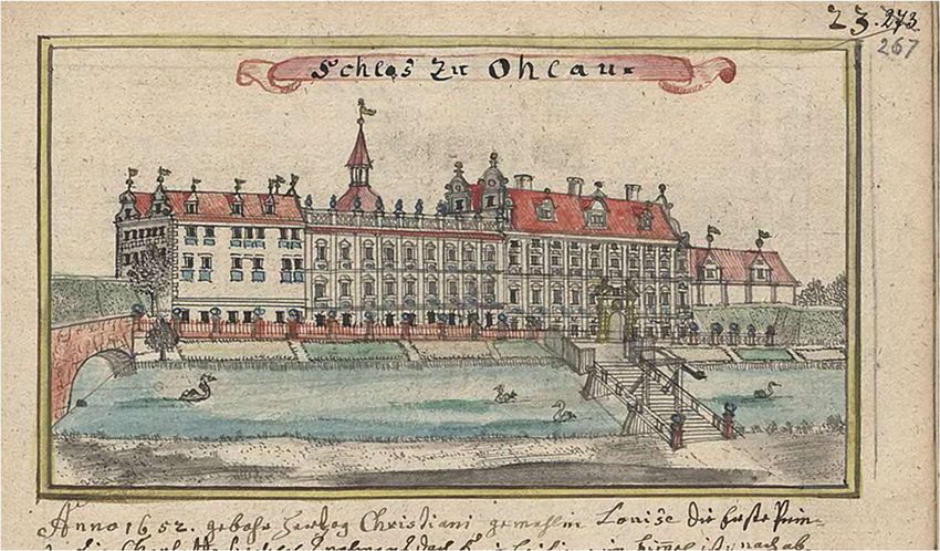
Preprints (www.preprints.org) | NOT PEER-REVIEWED | Posted: 25 January 2021

                                    tower, thus degrading the completely representative character of the castle complex [79].
                                    The castle square in the second half of the 19th century was turned into a green square
                                    with a monument to the Victory in the War of 1870 (Siegesdenkmal).
                                          In Wohlau, ravaged by the Thirty Years’ War, the castle was repaired and decorated
                                    in a new Baroque style. A representative bridge leading to the mansion over narrow
                                    moats was also built [23](pp. 1162-1163)[80]. It is very probable that already then, when
                                    demolishing the serviced buildings of the castle and the north-western corner of the
                                    market quarter, an entrance square was marked out from the municipality side. Along
                                    with these regulations, a modest green ground floor in front of the castle façade was
                                    perhaps introduced. They certainly existed already after the reconstruction ordered by
                                    the managers of the Wohlau camera, located in the residence, when after the death of the
                                    Duchess (1680) the land came under the direct rule of the imperial court [11](pp. 562,
                                    569).
                                          In Bernstadt (Bierutów), like in Ohlau, during the times of Christian Ulrich of
                                    Württemberg (1652-1704), front gardens were established on the foreground of the
                                    duke’s seat after the land had been cleared. Bernstadt from one of the subordinate urban
                                    centres in the Duchy of Oels (Oleśnica) changed in modern times into the seat of the side
                                    lines of the ruling family. The owners of the residence and the municipality tried to give
                                    it attractive external features, raising the importance of their family. As soon as Henry II
                                    (1507-1548), the third of the House of Poděbrady, took the reins of power, he chose the
                                    Bernstadt castle as his residence. In the years 1534-1540, he carried out thorough recon-
                                    struction and gave the castle Renaissance forms. In 1603, a fire wreaked havoc with the
                                    castle and the whole municipality. The eastern wing and tower burnt down, and recon-
                                    struction lasted for the next few decades [81](pp. 516-519)[82](pp. 22-30)[73](pp. 530-533).
                                    In spite of that, from 1618, Duke Henry Wenceslaus of Poděbrady lived here (1592-1639,
                                    Duke of Bernstadt in the years 1617-1639, and in the years 1629-1639 the General Gov-
                                    ernor of Silesia). The Bernstadt residence was a simple two-winged building (with
                                    southern and eastern buildings) with a preserved Gothic tower at the end of the eastern
                                    wing. Three-storey arcade porches were constructed at the wings, giving it a Renaissance
                                    character, and in 1622 the roof on the tower was replaced by an early Baroque glorious
                                    helmet. At the same time, the municipality, which gained the status of a ducal capital,
                                    was changing intensively and was expanding despite fires (1603, 1659). After the Würt-
                                    tembergs took over the Duchy of Oels in 1647, Bernstadt was, after the fire of 1659, an
                                    insignificant ducal seat [80][81](p. 467). However, in 1673, when the duchy was divided,
                                    it became the residence of Silvius Nimrod’s second son, Christian Ulrich. The eldest son,
                                    Silvius Frederick (1651-1697), received the Oels part, while the youngest, Julius, – the
                                    Juliusburg part, which was ruled by Elizabeth (1625-1686), as he was a minor until his
                                    death [83].
                                          Christian Ulrich resided in Bernstadt until the death of the oldest of his brothers,
                                    Silvius Frederick, in 1697, when he inherited Oels. During this period he took steps to
                                    modernize the castle. He expanded it by constructing one storey more. He also tried to
                                    raise its representativeness by changing the form of the avant-corps of the south wing,
                                    introducing there a Baroque portal decorated with the family coat of arms, while at the
                                    same time renovating the tower and crowning it with a helmet (1679-1680) [81](pp. 469,
                                    521-522). On the municipality’s side, in the wall closing the castle courtyard, a decorative
                                    gate in the form of a palladiana was inserted around 1680, and in front of it a bridge over
                                    the moat preceded by a small entrance square [A10]. A larger viewing foreground was
                                    probably to be ensured by replacing the last quarter adjacent to the castle with a riding
                                    arena Figure 4 [13](pp. 688-695). Gardens were to be an additional decoration and attrac-
                                    tion; a small Lustgarten with an orangery on the northern side of the castle, a castle gar-
                                    den on the southern side, and extensive gardens set up behind the municipality walls in
                                    the immediate vicinity of the residence [81](p. 521). These were realised under the close
                                    supervision and active collaboration of the Duke and his gardener Georg Herbst, who
                                    described the achievements in a work published in Oels [84]. The main entrance of the
                                    castle gate was located on a long viewing axis opening from the market square, via
Preprints (www.preprints.org) | NOT PEER-REVIEWED | Posted: 25 January 2021

                                    Breslauerstrasse, a view of the castle tower. From another point, the coat of arms portal of
                                    the main wing of the castle is visible through a side passage of the gate [85]. A line of
                                    trees was introduced parallel to the wall covering the garden. (Judging by Wernher’s
                                    drawing these were linden trees.) The espalier ran along the road connecting the gate
                                    with the church, or in fact the side gate in the church wall, which the Württemberg family
                                    used to go to the Duke’s lodge (founded by Duke Christian Ulrich in 1679, as confirmed
                                    by the coat of arms of Württemberg and his wife Anna Elizabeth of Anhalt-Bernburg).

                                                    Figure 4. Bernstadt Castle illustrated by F.B. Wernher 13(p. 691).

                                          From the Baroque arrangement only the portal of the entrance gate and the portal of
                                    the main castle wing have survived to this day; there the coats of arms commemorate the
                                    founders. In the panorama and views, the presence of the castle is still signalled by the
                                    tower with its magnificent Baroque coat of arms. In the foreground of the residence on
                                    the municipality side there is still greenery, no longer a regular line. A similar but even
                                    more modest arrangement of the entrance to the castle from the municipality side was
                                    realised in Praisnitz (Prusice), where only a short line of trees preceded the elevation of
                                    the residence 11(p. 651).
                                          All three successive wives of Duke Christian Ulrich received new palace buildings
                                    with extensive gardens. Maria Sybillia received the palace in Sybillenort (Szczodre) and
                                    Sophia Wilhelmina – the palace in Wilhelminenort (Brzozowiec). In Oels, the gardens
                                    were established only for the fourth wife of Duke Christian Ulrich – Sophia of Mecklen-
                                    burg at the beginning of the eighteenth century. Also his sister-in-law, Silvius Frederick’s
                                    wife – Eleonore Charlotte of Württemberg-Montbéliard (1656-1743), arranged a garden in
                                    Festenberg surrounded by rows of trees on the outskirts of the municipality 13
                                    (pp. 740-741). The impossibility of introducing green complexes in the immediate vicinity
                                    of the residence was compensated for by creating separate suburban gardens. In Liegnitz,
                                    the gardens of Duchess Anna Sophia of Mecklenburg were created at the Sophienthal
                                    manor house (1657) and behind the Goldberger (Złotoryjska) Gate (1672) 23(p. 1199). In
                                    Bernstadt, apart from the gardens within the municipality walls to the north and south, a
                                    large garden complex was also set up outside the municipality walls in the immediate
                                    vicinity of the castle.
                                          The compositional significance of trees in the urban layout was planned to be used
                                    in Silesia probably already before. Perhaps already in the first half of the 17th century it
Preprints (www.preprints.org) | NOT PEER-REVIEWED | Posted: 25 January 2021
was intended to link the layout of the Sagan (Żagań) palace with the Jesuit church, whose
guardian was the duke, with a properly designed composition of greenery on a vast area
obtained after the demolition of a part of the municipality buildings.
In 1549, the land of Sagan came directly under Habsburg rule. During the campaign
of the Thirty Years’ War, in 1627, Albrecht von Wallenstein appeared as one of the main
commanders of the imperial army in Silesia. In 1628, the Emperor, who was constantly
strengthening his court position, handed over the Duchy of Sagan as compensation for
outstanding financial obligations 86(pp. 59-68). Wallenstein started the reconstruction of
the municipality destroyed during the warfare. In this almost completely Protestant
centre he decided to create a centre of Catholicism and a magnificent seat of power. The
first manor house to be built was located at the New Market Square (present Słowiański
Square). At the same time Wallenstein started to build a palace in the place of a castle
demolished for this purpose 86(pp. 59-68). The residence, which combines defensive and
representative functions, was built based on the designs of Vincenzo Boccacci, the duke’s
architect. The four-winged form with bastions in the corners surrounded by a moat re-
ferred to the Gothic castle, reproducing the Renaissance solutions of the Italian defence
residences from the 16th century – palazzo in fortezza. The construction of the palace began
in the spring of 1630. The ground floor and walls of the first floor of the building were
erected on a three-metre-high platform. At the same time the new duke expelled the
Lutheran predecessors. He assigned an abandoned Franciscan monastery to the Jesuits.
In 1632 the reconstruction of the municipality was disturbed by the war. Sagan was
captured twice by General Arnim and the Swedish army. However, at the end of the year
Wallenstein regained Silesia. In 1633, the duke, who resided in Sagan, planned an exten-
sive construction of a Jesuit college and a convent for a hundred alumni. The project was
also developed by Vincenzo Boccaccio. The complex was to consist of two-storey build-
ings added to the former Franciscan church, grouped around four inner courtyards. Only
part of the work was carried out until Wallenstein suddenly died in 1634 86(pp. 82,
87-89).
In front of the palace in Sagan, which was built as a modern residence under Wal-
lenstein, it was decided to create a forecourt by deliberately demolishing the buildings.
The result was a large square which, together with the articulation of the palace’s façade,
was to create an urban system that was subordinated to typical Baroque rules. In order to
provide a suitable perspective for its seat, Wallenstein ordered the demolition of over 70
houses, which was largely carried out 86(pp. 63-68)88. Within this space, two composi-
tion axes were arranged, one facing the western façade, the other facing the northern,
shorter and linked to the façade of the opposite tenement. The latter was overshadowed
at the end of the 18th century by the palace of the duke’s administration (Herzogliches
Kammergebäude), a classicist building erected for the General Plenipotentiary of the
Sagan Duchy (now the district court). The longer composition axis ran in the middle of an
elongated square to the north of the municipality walls (currently occupied by the tower
apartment buildings), created after the demolition. It was a representative entrance to the
residence from the side of the square. The spacious square north of the mansion, obtained
by removing four quarters of the buildings connecting with the New Market Square, was
not finally arranged 5. Perhaps there were plans to completely clean up the space be-
tween the palace and the Jesuit college founded by Wallenstein in the former Franciscan
monastery stretching from the square along the municipality walls to the north Figure 5.
Undoubtedly, these were one of the broader plans to transform the municipality into a
representative space in front of the residence. The open square had dimensions of almost
130 by 150 m, and the farthest perspective view of the palace opened from the intersec-
tion of the streets behind the New Market (currently at the intersection of Słowackiego
and Teatralna Streets), i.e. at a distance of about 350 m. This allowed for the creation of
exceptionally monumental perspective compositions. Such extensive areas were proba-
bly planned as compositions with the use of greenery systems: tree espaliers and garden
parterre, as it was done in the immediate vicinity of the palace at the turn of the 18th and
19th centuries. However, there is no design evidence or records of this. Indirectly, suchPreprints (www.preprints.org) | NOT PEER-REVIEWED | Posted: 25 January 2021
plans may be evidenced by the care provided to the chateau garden surrounded by av-
enues with a zoo and a pheasantry garden 86(p. 60).
Figure 5. A fragment of the Sagan panorama showing a Jesuit palace and monastery with a church
in the mid-18th century 87.
3.3. Tree espaliers in municipalities and their periphery
The green areas introduced into the municipality limits had the character of front
garden parterres and tree espaliers, such as those in front of the residence in Bernstadt or
Prusnitz, which were beginning to become an increasingly important compositional el-
ement. In Bernstadt, as it was probably mentioned in the 1680s, a line of linden trees
protected the wall of the castle garden from the side of the municipality and marked the
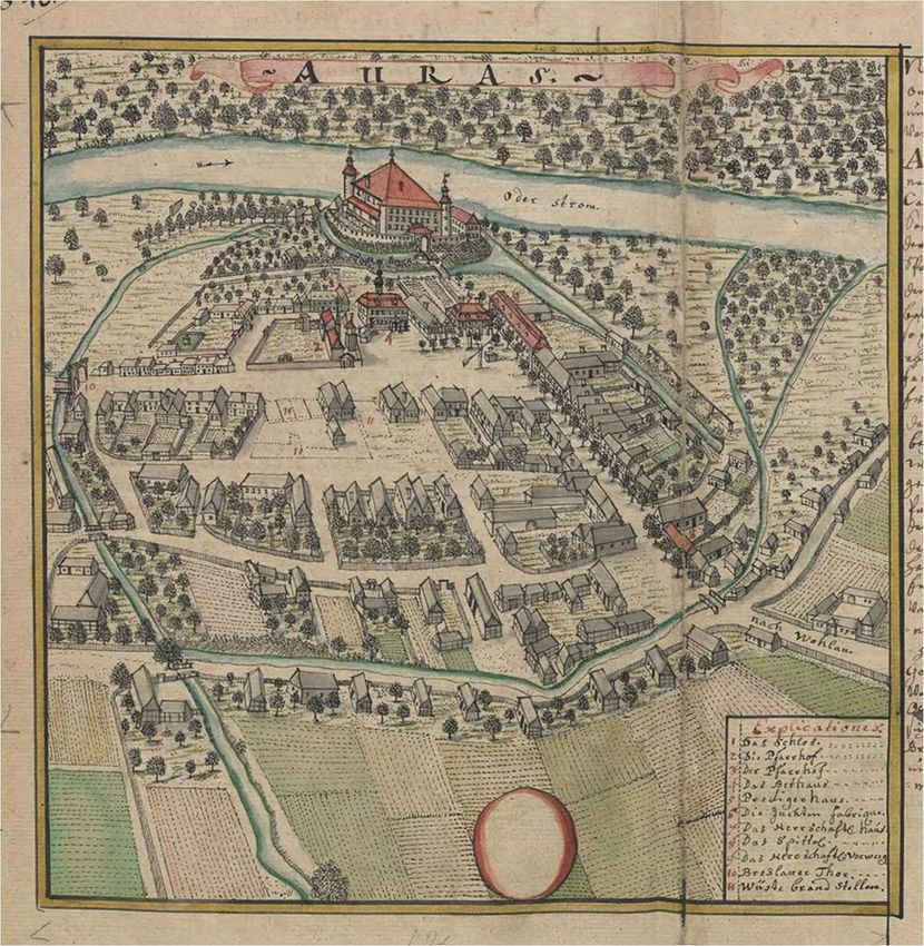
road serving the princely passage from the gate to the church. In a little town Auras
(Uras), the line planted along the façade of a yuft factory founded in 1722 by Philipp
Wilhelm Luther [89,90 and the accompanying residential buildings – the frontage of the
market square and the street – marked the road to the bridge and the castle portal Fig-
ure 6 10(p. 347). Wroclaw municipality-dweller Luther was granted an imperial patent
for exclusive production of yuft in Silesia 91 and appropriate privileges for imported
workers. He also took care of the hospital and suitable flats for them.Preprints (www.preprints.org) | NOT PEER-REVIEWED | Posted: 25 January 2021
Figure 6. Auras in the middle of the 18th century in a drawing by F.B. Wernher 10(p. 347)
Similarly to other European countries, tree espaliers and avenues were introduced in
Silesia as early as in the 17th century. The lime avenue in Leubus (Lubiąż) was described
as early as the end of the 17th century, so it had to be planted at least several dozen years
earlier 23(p. 1167). In Dyhernfurth (Brzeg Dolny), probably as early as 1666 or with the
foundation of the Stations of the Cross after 1701, an allée connecting the residence with
the sanctuary was planted 3(pp. 47-50, 90-94)4(p. 75). Trees also lined roads – the old road
to Wahren (Warzyń) and a new route from the village to the chapel and further towards
the Odra River (led along the border of the medieval location department) 9(pp.
410-411)8(p. 152). In Ohlau, a garden avenue was created in the 1670s, with walls in the
form of a hedge or trellis, was an extension of the composition axis of the residence be-
hind the moat in the suburban gardens 77. In Juliusburg, a palace and church garden and
a road from the manor house were planted in rows 13(pp. 700, 703). Regularly planted
trees appeared on the fortifications of the Legnica castle 11(pp. 7, 89). Avenues spread in
Silesia, and lines of trees were created in the municipalities and around their walls 25.
Both smaller Silesian municipalities, such as Haynau, Ghurau, Kant, Nimptsch,
Prochowitz, Steinau, Neumarkt, Goldberg and Landeshut (Chojnów, Góra, Kąty,
Niemcza, Prochowice, Ścinawa, Środa, Złotoryja and Kamienna Góra) 9(pp. 559-560,
484-485) 11(pp. 206-207, 208-209, 396-397)14(pp. 194-195) or much bigger as Wolau,
Ohlau, Bernstadt, Sagan, Oels 11(pp. 396-397, 562, 567) 13(pp. 688, 694-695)87 or
Schweidnitz (Świdnica) 15(pp. 343-344) [A11] 92. They were surrounded by rings of fruit
trees. Fortifications in Breslau (Wrocław) were provided with plantings on the southern
side of the municipality 9(pp. 196-199).
Even more widespread use was made of tree espaliers and avenues in the open
landscape. They were commonly used in the complexes of residences, as shown inPreprints (www.preprints.org) | NOT PEER-REVIEWED | Posted: 25 January 2021
Wernher’s drawings 9(pp. 390-589)11(pp. 373-619)1213(pp. 252-449, 662-681)14. They
were used as a kind of shielding and decoration of monotonous walls or railroad fences
and manor buildings of both extensive palace buildings and small manors. Such a line
was planted in the aforementioned palace in Sybillenort. They can be seen in illustrations
of numerous manor and palace complexes. Roads leading to palaces and manor houses
were also transformed into avenues.
The tree espaliers were planted along the roads leading to the churches of Peace in
Schweidnitz, Jauer (Jawor) [A12] and Glogau 16(p. 27)93. Three oak allées, of which
fragments of one have survived to this day, leading to the gates in the wall surrounding
the property of the Evangelical parish in Schweidnitz, were built together with its con-
struction, which is shown on plans from before the mid-18th century 94. An avenue also
led to the Church of Grace in Sagan 95. All those suburban Evangelical churches of Peace
and Grace were accompanied by cemeteries and schools and surrounded by lines of
trees. Then, already in Prussian times, roads to the churches and their fences were pro-
vided with plantings. Similarly, trees were planted along the church walls, and the ele-
vations of newly established Lutheran high schools, e.g. in Hirschberg (Jelenia Góra) 96,
as shown in Wernher’s drawings, which was in line with the state recommendations
concerning the plantings surrounding schools and temples.
All main roads leading from Breslau began to be lined with trees already before the
middle of the 18th century [A13] [97–99. At the turn of the 18th and 19th century they
transformed into highroads (Kunststrassen, Chausseen) 100 as well as many main roads in
the whole region 101. The Prussian national orders recommending the planting of trees
decided that most of them took on the character of an avenue. However, the avenues did
not become part of the composition of dense urban complexes of municipalities ex-
panding over time. The avenue in Tschepin (Szczepin), shown on plans from the end of
the 18th century, was not preserved in Breslau after it was incorporated into the urban
layout 102, nor the famous Scheitniger (Szczytnicka) Avenue – a poplar avenue (virgi-
nischen Pappeln, Populus deltoides), planted in 1790, leading to the park founded by
Friedrich Ludwig von Hohenlohe-Ingelfingen 103.
3.4. Avenues in squares and streets of Lower Silesian-Lusatian border municipalities
Avenues in the neighbourhood of Silesia started to play a role in the layout and
shaping of green urban interiors of municipalities. At that time, on the borderland of
Lusatia and the Neumark, which lay beyond the borders of the Habsburg state, there
were settlements related to the influx of religious fugitives, mainly from Silesia, valuable
craftsmen, especially weavers. Many of the centres, which were established at that time
as municipalities, lost their municipal rights quite quickly. Their beginnings, however,
and thus their spatial organisation, are connected with the process of their founding.
In the medieval village of Trebschen (Trzebiechów), first mentioned in 1308 and
situated in the Neumark, which in 1701 was incorporated into the Prussian state, a village
that developed around the local Renaissance manor house belonging to the Troschke
family from Züllichau (Sulechów) [A14]104(p. 344) a Lutheran border church was built in
1654. Religious fugitives, among them weavers, began to come here. In 1680 a new large
temple was erected 105. The expanding village was granted municipality rights by a
royal decree from 1707, and its then owner Konrad von Troschke named it after the first
Prussian king Frederick I Hohenzollern (1657-1713) – Friedrichshuld (Frederick’s Grace)
[26,106.Preprints (www.preprints.org) | NOT PEER-REVIEWED | Posted: 25 January 2021
Figure 7. Aleja Lipowa (Linden Allée) in Trzebiechowo. Fot. Piotr Frąszczak, www.polska-org.pl.
The new buildings (in 1719 it was 25 houses) were erected along an avenue planted
with double rows of lime trees, which connected the palace and the church (now Lipowa
Street) Figure 7. It was perhaps founded as early as 1680, and it certainly existed after
1707. It was designated as a composition axis connecting the entrance to the palace with
the dominant of the church tower. The central part formed a kind of elongated square in
the greenery, which was the centre of the municipality. It was complemented by park
avenues stretching north of the landowner's seat. The Baroque layout of the village is
well readable nowadays, although in 1823 a new building designed by K.F. Schinkel and
his collaborators was erected on the site of the previous Evangelical temple, and the
municipality houses were replaced after the fire of 1830, while the palace was rebuilt in
the 1870s and 1880s, when Trebschen lost its municipaly rights (1870) 9. Linden alley was
undoubtedly modelled largely on the Dresden Hauptstrasse as the closest example,
probably well known to the Saxon courtier. However, the most important model was
probably Berlin’s Uner den Linden, because of the patron of the municipality, the first
king in Prussia, mentioned in the name.
In 1679 the old settlement of Dziadoszanie – Halbau (Iłowa) was granted munici-
pality rights from the Elector of Saxony John George II (1613-1680) due to the request by
Countess Helga Margaret von Friesen. The rights were valid until 1830, when the town
was degraded to a market municipality (Marktflecken) [27,107. Its inhabitants were ref-
ugees from Silesia, who founded the first Evangelical parish in 1668 108(p. 836). The vil-
lage developed in the hands of a new (since 1682) owner, Count Balthasar Erdmann von
Promnitz, owner of Pless and Sorau (Pszczyna, Żary) 104(pp. 101-102)109, in the early
18th century. At that time, a rectangular market square was built up, with streets running
out of corners, situated to the southeast of the land property. The erection of an evangel-
ical parish church in 1720, designed by Giulio Simonetti [110,111, began after a fire in
1725, rebuilt and completed shortly before the next municipality fire, in 1749. At the same
time, the Renaissance manor house from 1626 was converted and extended with a Ba-
roque wing, giving it a palace-like form 108(p. 836). Both buildings of the church and the
palace, surmounted with towers protruding in front of the façades, were connected by a
viewing axis, which in time transformed into a street surrounded by frontages
[A15][24,27. At that time, around 1720, a second axial layout was also formed in Lin-
denstrasse (now K. Pułaskiego Street), located north of the first one, leading from the
residence to the east (at its end in the 19th century a parish house was built up) 113 Figure
8 [20]. It was an extended avenue forming a kind of square planted with lime trees. In
1816, it was already an impressive avenue, so it must have been built several dozen years
earlier 27. The choice of trees indicates the Berlin pattern. However, it should be re-Preprints (www.preprints.org) | NOT PEER-REVIEWED | Posted: 25 January 2021
membered that the founder knew the assumptions originating in Italy, France and the
Netherlands 104(p. 101). Greenery filling was not used in the case of the main urban in-
terior – a marketplace, which was traditionally shaped like a square with streets leading
from its corners; a second urban interior was added, probably related from the beginning
to the area belonging to the Protestant community, where the school and parish buildings
were erected 108(p. 836).
Figure 8. Halbau on a topographic plan from 1939 20
Within the borders of Silesia, which was taken over by the Prussian state, the first
example of the introduction of urban greenery was its implementation of a new munici-
pality established at that time – Neusalz (Nowa Sól). A significant economic problem of
Lower Silesia was the lack of deposits of rock salt. On the initiative of Emperor Ferdinand
I (1503-1564), attempts were made to become independent from the export of this prod-
uct from Poland. As a result, the settlement of Neusalzburg (Neusalz) was established,
where sea salt breweries began to operate from 1553, and which finally became a mu-
nicipality in 1743 from the edict of King Frederick II of Prussia 2(pp. 3-6, 29, 43 in, 136)
6(pp. 8-17).
Figure 9. Neusaltz’s perspective plan from the mid-18th century [14](pp. 172-173)Preprints (www.preprints.org) | NOT PEER-REVIEWED | Posted: 25 January 2021
Neusalz, which initially developed as a settlement on the Oder River, was later
given a Baroque irregular layout with the centre in the vicinity of the salworks and the
building of the salt office (later the town hall). Simultaneously with the granting of mu-
nicipality rights, King Frederick II gave permission for religious freedom, thus allowing
the settlement of the Moravian Brothers (Herrnhuter). On the route from Breslau to
Grünberg (Zielona Góra), along the section of the road connecting Neustädtel (Nowe
Miasteczko) and Wartenberg (Otyń), which was created with the formation of post rid-
ers, a colony was established, equipped with a house of prayer, hospital, school and
pharmacy 2(pp. 46, 49-52, 58 in.)6(p. 19). Residential buildings, identical storey houses,
stood on both sides of an avenue planted with chestnut trees Figure 9 2(p. 52)14(pp.
172-173). The choice of these trees, considered to be very ornamental, associated with
superfluousness, is evidence of a desire to accentuate wealth and emphasize prestige.
This shows a connection with Huguenot districts in German municipalities, but also with
very representative projects, e.g. in Bayreuth and Ansbach.
After the 1759 fire during the Third Silesian War, it was rebuilt again according to
strict rules from 1765 2(pp. 765, 73-75)114. The avenue existed in the 19th century, with
the last trees being removed at the beginning of the 20th century 115, and its memory was
immortalised by the name Kastanienallee (now Wrocławska Street).
Figure 10. The Herrhaag plan from the time of its creation. Extract from the plan 119Preprints (www.preprints.org) | NOT PEER-REVIEWED | Posted: 25 January 2021
The introduction of greenery into the centre of the layouts has become a principle in
the settlements of the Moravian Brothers. The Moravian (Czech) brothers under the care
of Nikolaus von Zinzendorf received permission to settle in Upper Lusatia in Herrnhut in
1722 and then in Herrnhaag in 1738, in Niesky in 1742 and in 1756 in Kleinwelka near
Bautzen. In Silesia, Frederick II allowed the construction of settlements in Neusaltz 1742,
Gnadenberg (Godnów, currently in Kruszyn, near Bolesławiec) and Gnadenfrei near
Reichenbach (Piława Górna, Dzierżoniów). Both settlements began to be built from 1743.
Much later, in 1772, the Brothers also settled in Gnadenfeld (Pawłowiczki) in Upper Si-
lesia [116–118]. Around the square with the house of prayer, their first settlement
Herrnhut (1722) and another Herrnhaag (1738) were built, although they did not have
municipality rights, but had a regular layout [7,8](pp. 194-198).
Figure 11. Gnadenfrei on a topographic plan from the early 20th century. Fragment of the plan 19
Figure 12. Gnadenberg of the topographical plan from the end of the 19th century. Fragment of the
plan 17
In Herrnhut, the central square was occupied by a large building of the community
house of prayer, the so-called Great Hall. In front of the house of prayer – opposite the
main axis of the complex marked outside the housing estate by an allée – a small front
garden was made 119. In Herrnhaag and Niesky the houses of prayer were erected in
frontages of squares, and their area was designated for extensive greenery, where rows of
trees, connected by fences surrounded green parterres [120,121 Figure 10. In Herrnhaag,
in the middle, a pavilion for a well was erected 122. In Gnadenfrei Figure 11, Gnadenberg
Figure 12 and Kleinwelka, initially the square was only decorated with trees, but as early
as the beginning of the 19th century it was also surrounded by hedges [122,123. This
connects them not only with the history of the introduction of avenues in European mu-
nicipalities, but also with the establishment of squares formed in a manner of a gardenYou can also read