Belmont walkways Walking Mountain Biking Dog Friendly Circular Track (Loop) - Walking Access
←
→
Page content transcription
If your browser does not render page correctly, please read the page content below
10/30/2020 Belmont walkways — NZ Walking Access Commission Ara Hīkoi Aotearoa
Belmont walkways
Walking
Mountain Biking
Dog Friendly
Circular Track (Loop)
Dif culties
Easy , Medium , Hard
Length
20 km
Journey Time
Between 1 hour and 8 hours, depending on track
Region
Wellington
Sub-Regions
Porirua City Wellington City
https://www.walkingaccess.govt.nz/track/belmont-walkways/pdfPreview 1/7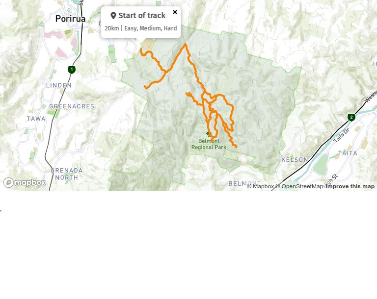
10/30/2020 Belmont walkways — NZ Walking Access Commission Ara Hīkoi Aotearoa
Porirua City , Wellington City
Part of Collections
Walking Access Commission Walkways , Belmont Regional Park
Track maintained by
Greater Wellington Regional Council
Belmont Walkway is the name for a collection of interconnected walking tracks in the Belmont
Regional Park, north of Wellington. The walkway takes in a variety of terrain, including rolling
hills, native forest and gentle streams. Below are some of the most popular options. All walking
times are for the return trip.
Dogs are permitted in the Korokoro, Stratton Street and Dry Creek valleys. Keep them under
control and remove droppings.
Waterfall Track
Moderate grade
1 hour
A pleasant scramble for all ages which follows Dry Creek from the park entrance through native
bush up towards a small waterfall and back again. Expect wet feet as you cross the stream
several times. Flat grassy areas near the start are ideal for picnics. Great for young family
groups, especially in summer.
Not suitable for buggies. Dogs OK - keep them under control and remove droppings.
You can download a map of this walk from the right of this screen.
Korokoro Dam Loop
Moderate grade
1 hour
A walk that takes in the historic Korokoro Dam, regenerating and mature native bush. Start at
the Oakleigh Street entrance to the park, at the track nearest the information kiosk.
https://www.walkingaccess.govt.nz/track/belmont-walkways/pdfPreview 2/710/30/2020 Belmont walkways — NZ Walking Access Commission Ara Hīkoi Aotearoa
Not suitable for mountain buggies. OK for backpacks. Dogs OK - keep them under control and
remove droppings.
Korokoro Stream Track
Easy grade
3 hours
This evenly graded track follows an old steel pipeline from the Cornish Street entrance
upstream through mature and regenerating bush to the Korokoro Dam. The dam was the rst
gravity fed concrete dam in New Zealand, built to supply water for the Petone Borough in 1903.
Return the same way or exit via Oakleigh Street.
Not suitable for mountain buggies. Dogs OK - keep them under control and remove droppings.
Boulder Hill Track
Moderate grade
2 hours
A scenic climb to Boulder Hill, starting at the Kaitangata Crescent, Kelson entrance to the park.
The track passes through regenerating scrub and native bush, giving good views of the Hutt
Valley on the way and sweeping vistas of Porirua harbour from the peneplain elds at the top.
Return the same way.
Not suitable for mountain buggies. No dogs.
Kilmister Track
Moderate grade
3 hours
Starting at the Hill Road entrance, this loop track gives panoramic views of Kelson and the lower
Hutt Valley, before following the main stream valley up to Belmont Road. Turn left to climb
gently southwest, passing the WWII munitions magazines on the way back to Hill Road.
Not suitable for mountain buggies. No dogs.
https://www.walkingaccess.govt.nz/track/belmont-walkways/pdfPreview 3/710/30/2020 Belmont walkways — NZ Walking Access Commission Ara Hīkoi Aotearoa
Please keep to the designated route. Walk closed August-November for lambing. You will need
to cross several streams.
Old Coach Road
Moderate grade
3 hours
The original route between Normandale and Pauatahanui, the Old Coach Road starts at the
top of Normandale Road and crosses Belmont Regional Park (including Waitangirua Farm) via a
road-sized track. It nishes at Belmont Road, off SH58.
Not suitable for mountain buggies as you need to cross several stiles. No dogs.
Please keep to the designated route. Walk closed August-November for lambing.
Belmont Trig Track
Strenuous grade
4 hours
Close to the city, yet with mature native forest and all-round views from the Tararua to the
Kaikoura ranges, this walk has it all. Pick a clear day and pack snacks, drinks, warm windproof
clothing and your camera. The walk starts and nishes at the Oakleigh Street entrance to the
park, descends to the Korokoro Dam then climbs via Baked Beans Bend to the Belmont Trig
(457m). Return via farmland and forest, enjoying tawa, kahikatea and rimu.
Not suitable for mountain buggies. Dogs allowed.
Maara Roa Valley Loop
Moderate grade
1 ½ hours
https://www.walkingaccess.govt.nz/track/belmont-walkways/pdfPreview 4/710/30/2020 Belmont walkways — NZ Walking Access Commission Ara Hīkoi Aotearoa
A walk through farmland and around the Cannons Creek forest. Enter at Takapu Road and follow
the track towards the right for views of the Cannons Creek headwaters and Cannons Head. Giving
good views of the proposed Transmission Gully motorway route, the walk follows the farm track
around to the left passing regenerating native forest and new plantings. Continue on to the
bridge over Cannons Creek then a steady climb back up to Takapu Road for great views over
Porirua Harbour.
Not suitable for mountain buggies. No dogs.
Cannons Head Track
Strenuous grade
4 hours
Entering at Cannons Creek Lake Reserve, you climb to Takapu Road, passing the Maara Roa
forest restoration project. Continue up a ridge to intersect with a track running between Belmont
Trig and Cannons Head, then turn left and follow the open ridge towards Cannons Head. The
track runs further along the ridge top before turning left back down to Cannons Creek. Worth the
effort, this half-day hike offers great views round the Hutt valley, Wellington and Porirua
harbours and towards the South Island. It is in wide open country, so take wind and waterproof
clothing, strong footwear, snack food and plenty to drink.
Not suitable for mountain buggies. No dogs.
Puke Ariki/ Haywards Korokoro Traverse
Strenuous grade
7-8 hours
Take the challenge! This rewarding full day walk traverses the length of Belmont Regional Park.
Starting at the Dry Creek ‘Haywards’ entrance the track rises to Boulder Hill, along farmland to
the Airstrip, Round Knob, Cannons Head and Belmont Trig. The track then descends into the
Korokoro Valley and exits at Cornish St in Petone. Along the way is a diverse range of landforms
and vegetation, from farmland to native forest.
Not suitable for mountain buggies. No dogs.
https://www.walkingaccess.govt.nz/track/belmont-walkways/pdfPreview 5/710/30/2020 Belmont walkways — NZ Walking Access Commission Ara Hīkoi Aotearoa
Conditions:
Dogs are permitted on leash in the Korokoro, Stratton St and Dry Creek Valleys. Dogs are not
permitted on or near farmland.The park has moderately steep hills and is exposed on the
tops to wind, rain and mist. Weather conditions can change quickly so please carry warm and
waterproof clothing and enough food and drink for your trip.
How to get here
282 Stratton Street, Maungaraki, Lower Hutt. Turn off State Highway 2 onto Dowse Drive and drive
3km. Turn onto Miromiro Road and then Stratton Street and drive 3km to the entrance of
Belmont Regional Park.
Track Elevation and Map
https://www.walkingaccess.govt.nz/track/belmont-walkways/pdfPreview 6/710/30/2020 Belmont walkways — NZ Walking Access Commission Ara Hīkoi Aotearoa More information http://www.gw.govt.nz/belmont/ Page last updated: Sep 8, 2020, 3:43 PM https://www.walkingaccess.govt.nz/track/belmont-walkways/pdfPreview 7/7
You can also read