Boundaries Procedures for boundary identification, demarcation and dispute resolution - RICS
←
→
Page content transcription
If your browser does not render page correctly, please read the page content below

GUIDANCE NOTE

          Boundaries
          Procedures for boundary
          identification, demarcation
          and dispute resolution
          England and Wales
          4th edition, February 2021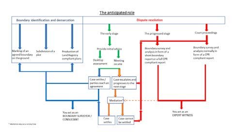
i
IP

     BOUNDARIES:
     PROCEDURES
     FOR BOUNDARY
     IDENTIFICATION,
     DEMARCATION AND
     DISPUTE RESOLUTION

     RICS guidance note, England and Wales
     4th edition, February 2021

     Effective from 1 May 2021

     Published by the Royal Institution of Chartered Surveyors (RICS)

     Parliament Square

     London

     SW1P 3AD

     www.rics.org

     No responsibility for loss or damage caused to any person acting or refraining
     from action as a result of the material included in this publication can be
     accepted by the authors or RICS.

     ISBN 978 1 78321 4082

     Produced by the RICS Boundaries Expert Working Group.

     © Royal Institution of Chartered Surveyors (RICS) February 2021. Copyright
     in all or part of this publication rests with RICS. Save where and to the extent
     expressly permitted within this document, no part of this work may be
     reproduced or used in any form or by any means including graphic, electronic,
     or mechanical, including photocopying, recording, taping or web distribution,
     without the written permission of RICS or in line with the rules of an existing
     licence.

     Typeset using Typefi
ii
IP
Acknowledgments
This guidance note was prepared by the members of the RICS Boundaries
Expert Working Group working under the auspices of the RICS Boundaries
and Party Walls Working Group (B&PWWG). The B&PWWG is a cross-
sector specialist panel of RICS members and related professionals from the
building, geospatial (land surveying) and rural areas of practice focussed
on neighbour disputes. The group’s remit includes boundaries, party walls
and certain easements such as rights-of-way and rights-of-light. All of these
are crucial to the physical and legal extent of property ownership and
their determination governs matters of use, adaptation, transactability and
value.
The B&PWWG also produces professional guidance and information, RICS
public guides, RICS client guides, policy responses and journal articles. It
is also actively involved with RICS Dispute Resolution Service (DRS) and
Neighbour Disputes orientated alternative dispute resolution and policy.
The B&PWWG exists to promote understanding and best practice in the
areas of land transfer, registration and administration, encroachments,
cadastre and boundary issues, this remit extending to an overview of the
relevant laws, both within the home nations of the United Kingdom and
overseas.
Boundaries Expert Working Group
Co-chair: Julia Stolle FRICS (Stolle Surveys Ltd)
Co-chair: Carl Calvert FRICS (Calvert Consulting)
Chair B&PWWG: John Lytton FRICS (Lawrence Foote & Partners (London)
Ltd)
Duncan A. Moss FRICS (Ordnance Survey Ltd)
Sarah Sherlock MSCSI MRICS (Murphy Surveys (Ireland))
Camilla Rhodes MRICS (Cambridgeshire County Council)
Sharon Rawlinson AssocRICS (HM Land Registry)
Jon Maynard FRICS
Nick Isaac QC (Tanfield Chambers)
Rob French FRICS (Delva Patman Redler)
Jack Norton MRICS (Schofield Surveyors Ltd)
Gary Jackson MRICS
BOUNDARIES: PROCEDURES FOR BOUNDARY IDENTIFICATION, DEMARCATION AND DISPUTE RESOLUTIONiii
IP
Grant Vincent FRICS (Dispute Mediation Consultancy LLP)
David J. Powell FRICS (David J Powell Surveys Ltd)
Michael Hannaway FRICS (Hannaway & Hannaway)
RICS standards lead
James Kavanagh MRICS (Director Land Group RICS)
RICS Publishing
Editor: Jo FitzLeverton
RICS would also like to thank Ordnance Survey and Cambridgeshire County
Council for all their hard work and professional input to this guidance note.
We would also like to thank HM Land Registry for all of their advice and
professional input on section 9.
B&PWWG output can be found on the RICS Land web page.
BOUNDARIES: PROCEDURES FOR BOUNDARY IDENTIFICATION, DEMARCATION AND DISPUTE RESOLUTIONiv
IP
Contents
Acknowledgments ������������������������������������������������������������������������������������������������ ii
RICS professional standards and guidance �������������������������������������������������� 1
RICS guidance notes ����������������������������������������������������������������������� 1
Boundary terminology ���������������������������������������������������������������������������������������� 3
1 Introduction ������������������������������������������������������������������������������������������������������ 5
1.1 Effective date ��������������������������������������������������������������������������� 6
2 Professional conduct ������������������������������������������������������������������������������������ 7
2.1 Conflicts of interest ��������������������������������������������������������������� 7
2.2 Acting with integrity �������������������������������������������������������������� 7
2.3 Competence ��������������������������������������������������������������������������� 8
2.4 Standards of service and complaints-handling procedure
��������������������������������������������������������������������������������������������������� 8
2.5 RICS investigations ���������������������������������������������������������������� 8
3 Stage 1 – Setting up the project ���������������������������������������������������������������� 9
3.1 Initial contact ��������������������������������������������������������������������������� 9
3.2 Anticipated role ��������������������������������������������������������������������� 10
3.3 Identifying the requirements ���������������������������������������������� 11
3.4 The contract �������������������������������������������������������������������������� 12
4 Stage 2 – Research ��������������������������������������������������������������������������������������� 14
4.1 Research and sources ������������������������������������������������������������ 14
4.2 Title deeds ������������������������������������������������������������������������������ 14
4.3 The registered title ���������������������������������������������������������������� 15
4.4 Extrinsic evidence ������������������������������������������������������������������ 16
5 Stage 3 – The site visit, measured survey and
photography �������������������������������������������������������������������������������������������������� 20
5.1 The site inspection ��������������������������������������������������������������� 20
5.2 Features on the ground ������������������������������������������������������� 20
5.3 Photographs �������������������������������������������������������������������������� 24
5.4 The measured survey ���������������������������������������������������������� 24
5.5 Instructing other specialist surveyors and advisers �������� 25
6 Stage 4 – The report ������������������������������������������������������������������������������������ 27
6.1 Analysis and preparation ����������������������������������������������������� 27
BOUNDARIES: PROCEDURES FOR BOUNDARY IDENTIFICATION, DEMARCATION AND DISPUTE RESOLUTIONv
IP
7 Stage 5 – Alternative dispute resolution �������������������������������������������� 29
7.1 Boundary Disputes Mediation Service ������������������������������� 29
7.2 Mediation of boundary related disputes ����������������������� 29
8 Stage 6 – Litigation �������������������������������������������������������������������������������������� 33
8.1 Before the courtroom ���������������������������������������������������������� 33
8.2 In the courtroom ������������������������������������������������������������������ 33
9 Stage 7 – Recording the outcome in HM Land Registry
����������������������������������������������������������������������������������������������������������������������������� 35
9.1 Application to record a boundary agreement at HM Land
Registry ���������������������������������������������������������������������������������� 35
9.2 Application for a determined boundary ���������������������������� 36
Appendix A References ����������������������������������������������������������������������������������� 38
Appendix B Mediation process and outline boundary
agreement ����������������������������������������������������������������������������������������������������� 40
B1 Mediation process ������������������������������������������������������������������� 40
B2 Example outline boundary agreement �������������������������������� 41
Appendix C Suggested checklist relevant to a boundary
dispute ������������������������������������������������������������������������������������������������������������� 43
Appendix D Model of terms of business for boundary
disputes ����������������������������������������������������������������������������������������������������������� 46
Appendix E Entering neighbouring land advice ������������������������������������ 48
Appendix F Boundaries relating to highways and public
rights of way �������������������������������������������������������������������������������������������������� 49
F1 Definition ������������������������������������������������������������������������������� 49
F2 Determination ����������������������������������������������������������������������� 49
F3 Ownership ����������������������������������������������������������������������������� 50
Appendix G..................................................................................... Glossary of
terms ����������������������������������������������������������������������������������������������������������������� 52
G1 Boundary terminology ��������������������������������������������������������� 52
G2 Other terminology ���������������������������������������������������������������� 54
G3 Land measurement for planning and development
purposes �������������������������������������������������������������������������������� 59
Appendix H Survey accuracy banding table �������������������������������������������� 61
Appendix I Data provenance ������������������������������������������������������������������������� 62
I1 Objective �������������������������������������������������������������������������������� 62
I2 Data sources ����������������������������������������������������������������������� 62
I3 Data provenance and referencing protocol table ������������� 64
BOUNDARIES: PROCEDURES FOR BOUNDARY IDENTIFICATION, DEMARCATION AND DISPUTE RESOLUTION1
IP
RICS professional standards and
guidance
RICS guidance notes
Definition and scope
RICS guidance notes set out good practice for RICS members and for firms that are regulated by RICS. An
RICS guidance note is a professional or personal standard for the purposes of RICS Rules of Conduct.
Guidance notes constitute areas of professional, behavioural competence and/or good practice. RICS
recognises that there may be exceptional circumstances in which it is appropriate for a member to depart
from these provisions – in such situations RICS may require the member to justify their decisions and
actions.
Application of these provisions in legal or disciplinary proceedings
In regulatory or disciplinary proceedings, RICS will take account of relevant guidance notes in deciding
whether a member acted professionally, appropriately and with reasonable competence. It is also likely
that during any legal proceedings a judge, adjudicator or equivalent will take RICS guidance notes into
account.
RICS recognises that there may be legislative requirements or regional, national or international standards
that take precedence over an RICS guidance note.
Document status defined
The following table shows the categories of RICS professional content and their definitions.
Publications status
Type of document Definition
RICS Rules of Conduct for Members and RICS Rules of These Rules set out the standards of professional
Conduct for Firms conduct and practice expected of members and
firms registered for regulation by RICS.
International standard High-level standard developed in collaboration with
other relevant bodies.
RICS professional statement (PS) Mandatory requirements for RICS members and
RICS regulated firms.
RICS guidance note (GN) A document that provides users with
recommendations or an approach for accepted
good practice as followed by competent and
conscientious practitioners.
BOUNDARIES: PROCEDURES FOR BOUNDARY IDENTIFICATION, DEMARCATION AND DISPUTE RESOLUTION2
IP
Type of document Definition
RICS code of practice (CoP) A document developed in collaboration with other
professional bodies and stakeholders that will have
the status of a professional statement or guidance
note.
RICS jurisdiction guide (JG) This provides relevant local market information
associated with an RICS international standard or
RICS professional statement. This will include local
legislation, associations and professional bodies
as well as any other useful information that will
help a user understand the local requirements
connected with the standard or statement. This
is not guidance or best practice material, but
rather information to support adoption and
implementation of the standard or statement
locally.
BOUNDARIES: PROCEDURES FOR BOUNDARY IDENTIFICATION, DEMARCATION AND DISPUTE RESOLUTION3
IP
Boundary terminology
The following are common usage references to boundaries:
Deeds and root of title Originating legal documents describing the property form the legal title
at first alienation (and subsequent transfers of ownership of land by
conveyance). Deeds relating to land ownership can be in the form of
historic conveyances and/or the HM Land Registry title and title plan.
Paper title boundary The paper title boundary is the intended boundary defined within the
originating conveyance of the land. At this time the paper boundary is also
the legal boundary.
Legal boundary The boundary established within a title’s first alienation. A legal boundary
is a notional line of no fixed width that separates one property from its
adjoining property and is as per that described in the deed[s] pertaining
to the plot. It may also define the extent of a legal interest in height, width
or depth that may be registered to the owner of the land or somebody
else or vested in another body. The legal boundary is often referred
to as the invisible line. The existing feature on the ground may or may
not coincide with the legal boundary. However, the legal boundary can
change after the date of the originating conveyance, by either a boundary
agreement or adverse possession.
General boundary England and Wales operate a ‘general boundaries’ system of land
registration (as does Ireland). A general boundary is defined in s60 Land
Registration Act 2002. A title plan with ‘general boundaries’ shows the
boundary of a property in relation to a given physical feature on the
ground, such as a wall or hedge as identified on the Ordnance Survey
map. A general boundary does not necessarily have any width and does
not identify the exact position of a legal boundary. The red edging on a
HM Land Registry title plan is therefore not definitive as to the precise
position of the boundaries. For this reason, official copies of title plans
carry the following warning:
‘This title plan shows the general position of the boundaries: it does not
show the exact line of the boundaries. Measurements scaled from this
plan may not match measurements between the same points on the
ground.’
BOUNDARIES: PROCEDURES FOR BOUNDARY IDENTIFICATION, DEMARCATION AND DISPUTE RESOLUTION4
IP
Determined boundary The Land Registration Act 2002 provides for the recording of
‘determined boundaries’. The aim is to record a boundary’s position to
a precision of +/- 10 mm. The determined boundary should be mapped
relative to surrounding ‘hard’ detail (anything made of brick, stone or
concrete that is expected to endure) to a high level of accuracy that
is certified by a chartered land surveyor. The intention is that another
chartered land surveyor would be able to relocate the boundary. A
determined boundary must be agreed between the neighbouring
landowners before it can be recorded.
Boundary agreement A verbal or written agreement between adjoining property owners that
precisely defines their joint boundary. Boundary agreements arising from
a mediated settlement are preferably in the form of a deed that can then
be placed on the parties’ HM Land Registry titles. The agreed boundary
may become the new agreed legal boundary (when registered at HM Land
Registry).
Physical boundary A physical boundary is represented by a visible feature on the ground,
such as a fence, wall or hedge, among other things, that is used and
accepted by the adjoining landowner(s) to define their joint boundary.
They all occupy three dimensions – length, breadth, and depth. A written
description of the boundary feature should be noted and recorded at the
time of survey, where possible. A physical boundary may not always be
present on site.
Registered boundary The registered boundary or registered extent can be either the general
boundary or the determined boundary, which is recorded at HM Land
Registry.
More definitions can be found in Appendix G.
BOUNDARIES: PROCEDURES FOR BOUNDARY IDENTIFICATION, DEMARCATION AND DISPUTE RESOLUTION5
IP
1 Introduction
The physical extent of property ownership and rights of use are basic attributes of land and buildings
(including utilities) and are capable of being evaluated by property professionals. Uncertainty of the extent
of ownership and its associated rights affects the physical use and rights to repair, maintain, gain access
to, develop on and obtain value from the land. Certainty is critical for the successful sale or purchase of
real property and it governs the enforceability of property rights, which can materially affect the value
of the property as collateral for a loan. The true physical extent of ownership and associated rights in
real property are fundamental to the successful registration of any property title, effective development
control and many aspects of the enforceability of regulations governing land, its ownership and use. These
rights may extend above and below the land’s surface.
As the pressures of development increase today, particularly in urban areas, boundaries (see Appendix
G for a full explanation of the different types of boundaries) and other intangible rights gain greater
importance, both economically and socially. Householders extend their houses and build extensions often
up to their boundaries, and developers are no different in wanting to maximise the use of their land. Not
surprisingly, uncertainty in the limits of ownership and rights of occupation has led to a steady increase in
disputed boundaries.
The purpose of this guidance note is to:
• provide RICS members with an understanding of the value and role that clearly identifiable boundaries
provide
• enable, wherever possible, accurate and comprehensible information to be provided by RICS members,
with as little scope for misunderstanding as practicable
• help in the event of a dispute over boundaries, to set out the facts in a manner that assists the parties,
their legal advisers and the courts and
• safeguard the interest of clients and promote public interest.
The aim of the RICS Boundaries Expert Working Group and the RICS Dispute Resolution Service is to
encourage private individuals, businesses and professional advisers (particularly the legal profession) to
select a suitably qualified RICS member as an expert who can scrutinise and understand the documents
and maps, carry out inspections and measured land surveys and prepare reports. In November 2020, RICS
and the Property Litigation Association (with endorsement from the Civil Justice Council) launched the
Boundary Disputes Mediation Service (BDMS) (see section 7.1).
There may also be a requirement to provide a formal expert report and present it to a court in the same
manner as any other expert witness. Currently, while some individuals and businesses are aware of the
existence of professionals who specialise in boundary demarcation, many are not. Therefore, they may
seek advice from unqualified persons, often to the detriment of an accurate diagnosis of the problem and
invariably leading to unnecessary expense, or worse still, ill-founded litigation. It is worth noting that justice
can only be achieved if both the claimant and the defendant have their cases presented properly and in
full. Accurate information and assessment at an early stage can often assist in obtaining a prompt and
cost-effective resolution of otherwise contentious cases.
BOUNDARIES: PROCEDURES FOR BOUNDARY IDENTIFICATION, DEMARCATION AND DISPUTE RESOLUTION6
IP
1.1 Effective date
This guidance note is effective from 1 May 2021.
BOUNDARIES: PROCEDURES FOR BOUNDARY IDENTIFICATION, DEMARCATION AND DISPUTE RESOLUTION7
IP
2 Professional conduct
While all expert boundary surveyors are required to act in accordance with their statutory and court-
appointed obligations, an RICS member is expected to meet RICS expectations of professional and
ethical behaviour commensurate with their membership, in addition to their duties to the court. RICS
considers these two considerations (strict adherence to the rules of the court and ethical conduct) to be
complementary, not mutually exclusive, professional obligations. Members should note that compliance
with the needs of the case may not itself be enough to achieve compliance with the standards expected of
an RICS member. Members have professional duties over and above serving client needs. For the purpose
of this guidance note, the following Rules from RICS Rules of Conduct for Members are particularly important:
• Rule 3: ‘Members shall at all times act with integrity and avoid conflicts of interest and avoid any actions
or situations that are inconsistent with their professional obligations.’
• Rule 4: ‘Members shall carry out their professional work with due skill, care and diligence and with
proper regard for the technical standards expected of them.’
• Rule 5: ‘Members shall carry out their professional work in a timely manner and with proper regard
for standards of service and customer care expected of them.’ Where an RICS member is appointed
as a boundary surveyor, there should be a tangible benefit to the client, in terms of the requisite
competence, professional impartiality, ethical behaviour and client care of an RICS member.
2.1 Conflicts of interest
Members should refer to the current edition of Conflicts of interest, RICS professional statement. RICS
members are expected to avoid actual or perceived conflicts of interest when accepting boundary dispute
appointments. RICS members should also consider whether a conflict may arise during the appointment
and whether that conflict renders them incapable of performing the role. Once appointed as an expert
witness, RICS members perform a specific professional function. They no longer owe sole responsibility to
the party that makes the appointment but also owe duties to both parties to the dispute, and to provide
professional insight based on evidence and knowledge to the client and court. RICS members should
consider their position in relation to all parties as part of any conflict-checking procedures.
RICS may ask members to demonstrate that they have considered whether a conflict of interest, or a
perception of conflict, has arisen and what steps they have taken to avoid or manage that conflict.
2.2 Acting with integrity
Neighbour disputes can be fractious. RICS expects its members to be honest, straightforward and
trustworthy in all that they do. This can relate to both the way they interact with the parties and the
way they make decisions pursuant to their appointment. The RICS Global Professional and Ethical
Standards define acting with integrity as:
• Being trustworthy in all that you do.
• Being open and transparent in the way you work. Sharing appropriate and necessary information with
your clients and/or others to conduct business and doing so in a way so they can understand that
information.
BOUNDARIES: PROCEDURES FOR BOUNDARY IDENTIFICATION, DEMARCATION AND DISPUTE RESOLUTION8
IP
• Respecting confidential information of your clients and potential clients. Not divulging information to
others unless it is appropriate and authorised to do so.
• Not taking advantage of a client, a colleague, a third party or anyone to whom you owe a duty of care.
• Not allowing bias, conflict of interest or the undue influence of others to override your professional or
business judgements and obligations.
• Making clear to all interested parties where a conflict of interest, or even a potential conflict of interest,
arises between you or your employer and your client (any subsequent decision to continue with an
instruction should be recorded and agreed).
• Not offering or accepting gifts, hospitality or services, which might suggest an improper obligation.
• Acting consistently in the public interest when it comes to making decisions or providing advice.
2.3 Competence
In the context of expert boundary surveyors, regulatory complaints can arise from poor professional
conduct or from incompetence. RICS members should ensure that at all stages throughout their
appointment, they undertake their work with due care and diligence, having an appropriate level of
knowledge, and with proper regard to the technical standards expected of them. The purpose of this
guidance note is to assist RICS members in understanding the technical standards expected of them
and to underline that RICS members should not take instructions outside of their area of competence,
expertise and knowledge.
2.4 Standards of service and complaints-handling procedure
RICS Rules of Conduct for Firms require all firms to operate a complaints-handling procedure (CHP). They
should be prepared to provide a copy of the procedure when asked.
All RICS members are expected to provide a proper standard of service pursuant to Rule 5 of RICS Rules
of Conduct for Members. If a complaint is received about work being carried out under a contract with an
RICS regulated firm, the firm’s CHP should be followed. In the case of a member working through a non-
regulated firm, the member must still follow Rule 5 when addressing that complaint.
2.5 RICS investigations
This guidance is intended to ensure that parties to the dispute do not try to challenge the substance or
outcome of a dispute through the RICS complaints process rather than using an appropriate method
of alternative dispute resolution, such as mediation, or other court approved appeal process. Nothing
prevents RICS from investigating and acting in relation to alleged breaches of RICS Rules of Conduct where
it believes it is appropriate to do so in an ongoing boundary dispute matter, but the parties cannot seek
from RICS any determination inconsistent with court proceedings. It is entirely at the discretion of RICS to
decide whether it should start or continue an investigation into a member’s professional conduct while
boundary dispute matters are ongoing. Should an RICS member wish to ask for matters to be put on hold,
that member should explain why an RICS investigation would interfere with the outcome of a dispute. For
more information, refer to the current edition of Complaints handling, RICS guidance note.
BOUNDARIES: PROCEDURES FOR BOUNDARY IDENTIFICATION, DEMARCATION AND DISPUTE RESOLUTION9
IP
3 Stage 1 – Setting up the project
This stage covers the various steps that occur from initial contact to confirmation of instructions. It is
essentially a dialogue between the RICS member and the client and/or their adviser (for litigious cases the
adviser is usually a solicitor). During the dialogue, the RICS member:
• identifies the key issues and requirements
• considers any due diligence issues and potential professional conflicts of interest
• ascertains which issues are within their competence and that they can help with, and gives clear
guidance as to what can and can’t be done and
• gives some idea of the cost and the basis of charging and anticipated timescale for carrying out the
proposed work.
3.1 Initial contact
Initial contact may arise in one of the following ways:
3.1.1 Direct contact by a member of the public
This initial contact needs to be handled carefully because the potential client may have little knowledge
of what an RICS member does and the limitations of their role. They may have unrealistic expectations
and may assume that the RICS member can provide a complete and definitive solution to the boundary
problem. The RICS member should emphasise that they can only deal with the surveying-related aspects
of the dispute and that for definitive legal advice a client will need to consult a lawyer. The difference
between acting as a surveyor/consultant or as an expert witness should also be emphasised at this stage
in order to avoid any possible misunderstandings.
3.1.2 Professional advisers
This can include solicitors, architects, planners, consulting engineers and other RICS members. They
(especially solicitors) should have a greater awareness of what the instructed RICS member can and cannot
do, but there will still have to be a process of defining the precise issues to be addressed. RICS members
should ask for a clear letter of instructions to avoid any future misunderstandings.
3.1.3 Direction of the courts
Where litigation is already in process, the judge may make an order that a particular expert (agreed
between the legal representatives) should be instructed to do specific work. In this scenario, the actual
contact (instructions) will usually come from the legal representatives, normally the solicitor for either
party. Further details are contained in the Civil Procedure Rules Part 35 (CPR 35).
3.1.4 Alternative Dispute Resolution
This is dealt with in detail at section 7, but in general terms courts are keen for the parties to resolve
matters out of court by ADR, of which mediation is an important part. Referrals to the RICS member may
come from various sources including the legal profession, direct from the public, mediation providers or
indeed the RICS Neighbour Disputes Service.
BOUNDARIES: PROCEDURES FOR BOUNDARY IDENTIFICATION, DEMARCATION AND DISPUTE RESOLUTION10
IP
3.1.5 Nil-cost initial consultations
RICS operates a scheme by which volunteer expert members may be contacted by the public for a free
half hour consultation by telephone. Although there is no fee involved, the RICS member may be liable for
the advice given, which should be of the highest professional standard.
Irrespective of the mode of initial contact, it is vital not to be drawn into expressing an opinion on the
matter for investigation at this stage: the initial contact may come from someone wishing to find an
expert who agrees with their own view. All the RICS member needs to do is identify the key issues and
requirements and whether the nature of work involved is within their sphere of expertise and competence.
If the RICS member is qualified and prepared to undertake the work this should be stated together with
the typical terms of business that might apply.
3.2 Anticipated role
There are two types of anticipated role:
• Boundary identification and demarcation may involve the marking of an agreed boundary, the
identification of an existing or previously existing boundary feature, the subdivision of a plot or the
production of HM Land Registry compliant plans. Those tasks can be carried out by a boundary
surveyor/consultant who has the relevant experience in this field (see section 5.2).
• Dispute resolution, on the other hand, covers contentious cases where there is often a disagreement
over boundary issues such as the precise line of the boundary, rights of way or access, etc. In this case
the RICS member’s report may be used in court or within the mediation process, when they will be
acting as an expert witness or as a single joint expert when instructed by both sides.
It is important to establish early on which role applies. The RICS member may start off as a boundary
surveyor or consultant, providing initial advice on a boundary or right-of-way matter in the form of a
desktop assessment or a meeting on site. However, it is paramount that the RICS member is aware that a
case may not settle and a more in-depth analysis, including a boundary survey, might become necessary.
In this scenario, the RICS member may now be required to act as an expert witness. Although CPR 35
strictly only applies to expert witnesses, it is good practice to execute all work in the spirit of CPR 35. There
is nothing to be gained by giving the client partial or biased advice at any time, since this might encourage
them to adopt a position that would be untenable in the more rigorous setting of court proceedings or a
mediation. A point that cannot be stressed enough to the client is that under CPR 35 the RICS member’s
primary responsibility is to the court, not to the parties instructing or paying them.
It is also important that the RICS member explains the different roles to the potential client. If the RICS
member provides the service of a boundary surveyor or consultant, but would not be able to act as an
expert witness, the RICS member should make this position clear before accepting instructions. It can be
very frustrating and possibly costly for a client if an RICS member withdraws from a case at a later stage.
It is often prudent to have separate terms of business for expert witness cases as the relevant caveats can
be usefully included within them. The standard terms of business (for non-contentious cases) should note
when other terms of business apply to expert witness work.
Figure 1 illustrates the role of a boundary surveyor/consultant/mediator and an expert witness, and the
areas where the roles could potentially overlap.
BOUNDARIES: PROCEDURES FOR BOUNDARY IDENTIFICATION, DEMARCATION AND DISPUTE RESOLUTION11 IP Figure 1: Roles and responsibilities Summarising, it is important, regardless of whether the RICS member acts as a boundary surveyor/ consultant or as an expert witness, that they provide an impartial opinion on matters within their expertise, even if it is different from the client’s view. 3.3 Identifying the requirements The RICS member should identify the client’s requirements. Services that may be offered include: • evidence gathering (stage 2) • accurate measured survey of the land (stage 3) • analysis (stage 4) • presentation of results in a plan or report (stage 4) • mediator for both parties in dispute (stage 5) • a party’s technical expert at mediation (stage 5) • expert witness for one party or single joint expert for both (stage 6) and • giving evidence in court (stage 6). The expert RICS member should be confident that the requirements are within the ambit of their professional knowledge and competence (section 2.3); that they have the correct training and experience for the task; and have adequate professional indemnity insurance (PII). Before accepting an instruction: BOUNDARIES: PROCEDURES FOR BOUNDARY IDENTIFICATION, DEMARCATION AND DISPUTE RESOLUTION
12
  IP

   RICS members are not publicly appointed quasi-judicial officials with the power to make legally binding
   decisions. They provide a service to the client, lawyers and the court that helps to resolve the problem, but
   they have no power to bind the court, which has the sole discretion on whether to accept (in whole or in
   part) or reject the solution put forward.

   RICS members are not the client’s case manager and should not comment on the strengths and
   weaknesses of the legal arguments.

   Commonly, in boundary cases a great deal of information is given, much of which is not relevant to the
   RICS member: general problems with the neighbour, harassment, damage, planning, amenity, lifestyle,
   etc. The RICS member needs to establish the issues that they can help with (essentially plans, maps and
   photos, evidence of factors that are visible on the ground, and measurement). The RICS member should
   identify the evidence relevant to these issues and advise who to turn to on non-survey issues, which may
   include:

   3.4      The contract
   At the end of the setting-up stage, the client should be clear what the RICS member is going to do, what
   form the final settlement may take (a boundary agreement or determined boundary for example), the
   form of the results, the likely costs or basis of fee charging and the likely timescale for producing the work.
   The client should also be aware of what the RICS member will not do, and the fact that – since the RICS
   member is impartial – the RICS member’s conclusions may be different from their own.

   The client or their professional adviser should send confirmation of instructions that will formally set out
   what the RICS member is to do and will normally include the evidence being supplied to the RICS member.
   In some cases, the letter of instruction may be copied in the RICS member’s final report.

   3.4.1 Fees
   The RICS member should in any event confirm the requirement and set out (where appropriate) the
   basis of charging the likely cost and the responsibility for and timing of payment(s). In litigious cases and
   expert witness work, RICS recommends contracting through professional advisers (usually solicitors)
   wherever possible. In the event of late or non-payment this can make final payment easier to pursue than
   with private individuals. If the contract is with the solicitor, that solicitor/firm are responsible for the RICS
   member’s fees unless they state otherwise, although it is wise to obtain a formal letter of undertaking. It is
   good practice to include the RICS member’s terms and conditions with the contract or engagement letter.

   A model terms of business can be found in Appendix D.

   Reference should also be made to the current edition of Surveyors acting as expert witnesses, RICS
   practice statement, and any other protocols (for instance, the protocol for appointment of experts in CPR
   35) that apply.

   RICS members are reminded again of their professional competence obligations (section 2). It is advisable
   for the RICS member to present a copy of their fee schedule to the client and/or professional adviser prior
   to undertaking any significant work.

   The RICS member must be able to show that their costs are reasonable. This may be done by
   demonstrating:

BOUNDARIES: PROCEDURES FOR BOUNDARY IDENTIFICATION, DEMARCATION AND DISPUTE RESOLUTION
13
  IP

   There are several logical points when an invoice may be raised. The first is on completion of the expert
   report. There may then follow a period of months (or even years) when little happens apart from requests
   for copies of the report and the occasional meeting being made. Sometimes a meeting of experts may
   be required. A running total of costs during this period should be maintained and invoiced at appropriate
   points.

   This will be followed by either the settlement, a mediation or a court appearance. Sometimes the case is
   settled out of court at the very last minute, and the RICS member will be expected to produce detailed,
   justifiable, and reasonable costings immediately.

BOUNDARIES: PROCEDURES FOR BOUNDARY IDENTIFICATION, DEMARCATION AND DISPUTE RESOLUTION
14
  IP

   4 Stage 2 – Research

   4.1 Research and sources
   There are three classes of evidence:

   Research in the case of boundary disputes usually means documents, and many documents are the
   subject of copyright. The Copyright Designs and Patents Act (CDPA1988) has certain sections that define
   infringement free copying, but unless the surveyor is aware of the delicate balance between infringement
   and non-infringement it is always best to determine the terms of any copying from the copyright holder.
   Both Ordnance Survey (OS) and HM Land Registry data, maps and documents are Crown Copyright (OS
   Open Data is subject to OGL3).

   The first thing to remember is that any research, whether needed for an opinion or expert report, needs
   to be relevant to the matter in hand. There will often be a discussion between any or all the clients and
   their legal representatives. It is at this stage that the initial details of the dispute are aired.

   Generally, the RICS member will be invited to give an opinion on their proposed methodology and
   the evidential resources that they are likely to need. The information needed may take time to both
   identify and acquire. The RICS member is often supplied with many – sometimes poorly reproduced –
   documentary sources, which are collectively known as the ‘case bundle’. Time will be needed to examine
   these documents carefully and, if necessary, to obtain better quality copies (copies may also exist that
   have been certified by a professional or notary). Normally this takes a few weeks and should be completed
   before the first site visit takes place. The evidence will relate to many questions, including:

   4.2 Title deeds
   Title deeds are the legal documents by which land is or was bought and sold, these may include
   conveyances, assignments, transfers, and indentures. The root of title is the document with which the
   evidence of title commences. An acceptable ‘root of title’ may in legal terms be no more than 15 years but
   the document that first created the plot of land may be of any age – even ancient. Registration will not
   (other than in exceptional cases) define the boundaries of the land within a registered estate. In theory
   the root of title can be identified for every plot, but in practice the old deeds have often been lost or
   destroyed. Registration of land aims to provide an accurate reflection of the state of the registered title
   and so pre-registration deeds may have been discarded or destroyed.

   The old deeds (if they exist) can be very useful for an RICS member trying to identify the precise boundary
   line.

   Every conveyance contains a ‘parcels clause’ that describes the land. This may consist simply of a
   textual description, or there may be an attached plan. In some cases, the text of the conveyance takes
   precedence over the plan, which is marked as being ‘for identification purposes only’. In others, the land is
   ‘more particularly delineated’ and the plan is definitive. Sometimes the two phrases are combined, and it
   is unclear as to whether the text or plan is definitive. Where the conveyance is vague or ambiguous a court
   will consider the conveyance as a whole and may take surrounding circumstances into account. The RICS
   member will assist the parties and the court best by giving an analysis of the plan at face value, and to
   avoid legal interpretation.

BOUNDARIES: PROCEDURES FOR BOUNDARY IDENTIFICATION, DEMARCATION AND DISPUTE RESOLUTION
15
  IP

   Since a boundary, by its nature, separates two parcels of land in different ownership, it is important to
   try to obtain the deeds for both in order to give unbiased advice. This may be difficult since the deeds for
   unregistered land may be held by private individuals, solicitors, mortgage companies, landed estates, or
   estate surveyors, who may be unwilling or unable to provide copies. Copies are sometimes referred to in
   the register, and if they are noted as ‘copy filed’ or similar it should be possible to obtain them from HM
   Land Registry via the Portal or NLIS, or by using form OC2 sent to HM Land Registry. All documentation,
   except ‘exempt documents’ (usually available documents with commercially sensitive information greyed
   out), held by HM Land Registry is open to public inspection. It can be obtained using form OC2, giving as
   full a description as possible of what is required, and HM Land Registry will supply all the information that
   it holds on file even if it is not referred to on the Register.

   An RICS member should be aware that the quality of any plan attached or referenced in a title deed is
   variable. If it is a copy of an OS map, it is a good idea to try and determine which one at which date and
   obtain a copy of that OS map from one of the copyright libraries. Furthermore, the deed plans of adjoining
   properties may overlap, this can be a common source of dispute and it is good practice to establish if this
   is the case early on in an instruction. Even on registered properties there may be an unregistered sliver
   between them. This can be commonly referred to as a ‘ransom strip’ and is usually highlighted during an
   appropriate due diligence process. It should be taken that any sections on a title plan that are rendered
   ‘white’ due to the cartographic limitations of the base mapping and the bluntness of traditional ‘red’ edging
   are unregistered.

   ‘T’ marks on the deed plan may or may not be defined in the deed and if they are, they usually signify who
   is to erect and/or maintain the marked boundary feature. ‘T’ marks generally will not be shown on the title
   plan. RICS members should bear in mind that deed plans show lines and it is what those lines represent
   that is important too. The interpretation of ‘T’ marks is a matter of law.

   4.3 The registered title
   Official copies of the land register and title plan can be obtained from the HM Land Registry. Registered
   users may access HM Land Registry portal for details of available services such as searches of the index
   map, register searches, value-added services, etc. Plans obtained online are sometimes pixelated and
   liable to scaling error when printed by the user. Copies obtained by post directly from HM Land Registry
   are at the intended scale and easily copied.

   HM Land Registry guaranteeing the title is not the same as guaranteeing the extent of the title. Under the
   general boundaries rule (section 60 Land Registration Act 2002), Land Registry plans do not show legal
   boundary lines. Their sole purpose is to identify plots of land, not the legal boundaries of that land. The
   legal boundary is a line of no thickness.

   The registered title will have an OS plan as the base onto which the land parcel registered will be plotted
   according to the information given to HM Land Registry at the time of first registration.

   OS mapping is of a defined accuracy, and therefore subject to the limitations of specification. Changes
   to the property may result in the title plan being re-issued based on more up-to-date mapping. The plan
   is based on the deeds supplied when that parcel of land was first registered at HM Land Registry. HM
   Land Registry will only commission a survey of the property when there is a problem in matching the
   deeds to the OS mapping. If the property and its extent are not fully defined by features on the map,
   HM Land Registry will plot any undefined boundaries using dotted lines. Older titles may only be held in
   paper format, though most have now been scanned into a digital raster format, and newly created plans

BOUNDARIES: PROCEDURES FOR BOUNDARY IDENTIFICATION, DEMARCATION AND DISPUTE RESOLUTION
16
  IP

   are held electronically in vector format. Whatever format the title plan is held in, do not scale from them
   (remembering that digital mapping data contains all of the scale limitations of paper copy). Also be aware
   that title plans are usually at 1:1250 but the OS map on which they are based may be at 1:2500 or 1:10,000.
   Older title plans may well have a Crown Copyright date – this can be used as a cross-reference to find the
   original OS map that can then be examined – whereas newer ones do not and there is not an explicit link
   to the date of the OS mapping used.

   4.4 Extrinsic evidence
   Given the limitations of property deeds and HM Land Registry title plans, the RICS member will need to
   look at other sources of evidence to try to establish the precise boundary line and check whether this
   coincides with the current boundary features. The court determines the admissibility of evidence and the
   evidential weight to be given. Some of the main sources of evidence include:

   4.4.1 Ordnance Survey mapping
   Under the Public Sector Geospatial Agreement (PSGA), Ordnance Survey (OS) provides Great Britain’s
   national mapping services. As part of its Public Task, Ordnance Survey creates, maintains and improves the
   National Geographic Database (NGD), which contains the data that describes the geography of Britain. Visit
   the Our Public Task webpage of the OS website for further information.

   OS MasterMap® Topography Layer and OS MasterMap® Imagery Layer are both highly detailed
   topographic products, which provide valuable information in a boundary dispute case, though it needs to
   be understood from the outset that Ordnance Survey maps show only physical topographic features and
   make no comment on land and property ownership boundaries or rights. OS MasterMap® Topography
   Layer contains data that has historically been surveyed at three ‘basic scales’:

   *with the associated accuracy referenced in Table 1.

    Original survey scale     99% confidence level        95% confidence level      RSME*

    1:1250

    Absolute accuracy          0.9m                       0.8m                      0.5m

    Relative accuracy          +/- 1.1m (up to 60m)       +/- 0.9m (up to 60m)      +/- 0.5m (up to 60m)

    1:2500

    Absolute accuracy          2.4m                       1.9m                      1.1m

       Relative accuracy       +/- 2.5m (up to 100m)      +/- 1.9m (up to 100m)     +/- 1.0m (up to 100m)

       1:10 000

       Absolute accuracy       8.8m                       7.1m                      4.1m

       Relative accuracy       +/- 10.1m (up to 500m)     +/- 7.7m (up to 500m)     +/- 4.0m (up to 500m)

   Table 1: Ordnance Survey mapping accuracies of large-scale topographic mapping data. © Ordnance
   Survey Limited 2020

BOUNDARIES: PROCEDURES FOR BOUNDARY IDENTIFICATION, DEMARCATION AND DISPUTE RESOLUTION
17 IP Confidence level is the probability that the value of a parameter falls within a specified range of values. *RMSE (root mean square error) is the square root of the mean of the squares of the errors between the observations. It is a measure of the accuracy by comparing the actual measurements to the ‘most likely’ value. In practical terms this means that 68% (one σ) in a representative sample of points shall be correct to better than the stated accuracy value. In civil law cases where the standard of proof rests upon the balance of probabilities of something being true or not, RMSE (one σ) becomes an important measure. For example, if the question under consideration is ’is a point on a map accurate to 0.5m?’ and the RMSE of that map is known to be 0.5m, there is a 68% chance that the point is accurate to 0.5m. Therefore, on the balance of probabilities the answer is yes, as a 68% chance is clearly greater than a 50% chance and so it is more likely to be accurate to 0.5m than not. Ordnance Survey, in common with many mapping authorities around the world, defines accuracy in three ways: absolute accuracy, relative accuracy, and geometric fidelity. Of these, relative accuracy is usually the most relevant to boundary disputes. A general boundary does not necessarily have any width and does not identify the exact position of a legal boundary. The majority of titles are registered with general boundaries and the title mapping is usually carried out with respect to, and therefore relative to, the features on the OS map rather than with reference to the underlying absolute coordinates of those features on the underlying OS map. If the features on the OS map are repositioned, for example due to resurveying or data quality improvement, the general boundary of the title may also be shifted to agree with the revised position of those same features on the OS map. It is therefore generally not valid to take the absolute coordinates of features from the title plan or OS map, establish these on the ground using precise survey methods, and claim that these represent the exact true position of boundary features. No matter how precise the surveying, the position established will not exceed the accuracy of the original features found on the underlying OS base map. The relative distance between features on the OS map is very useful. These relative distances should correspond, within the accuracy limits, to the distances between the same features on the ground as long as the features on the map are the same as those on the ground and have been correctly identified. It is for these reasons that the relative accuracy of the map is normally the most relevant when considering property boundaries rather than the absolute accuracy. The exception to the above is where a determined boundary survey using coordinates has been carried out in accordance with HM Land Registry practice guide 40 section 4.4.2 in which case the OSGB absolute coordinates when defined using GNSS and subsequently transformation to OSGB36 (the Universal Transverse Mercator coordinate system as defined by the re-triangulation of 1936 – 1962) are officially recognised. In such cases it is the absolute and relative accuracy of the determined boundary survey, rather than the accuracy of the OS map, which is important. It should be noted that the Land Register of England and Wales comprises more than 25 million titles, the vast majority of which are registered with general boundaries. The total number of determined boundaries is thought to be in the order of a few thousand. As Table 1 shows, accuracy is historically related to scale. Older map series such as the Ordnance Survey County Series 1:2500 maps from the late 19th century onwards, or OS National Grid (Overhauled) Mapping, may not achieve the accuracy levels stated above. It should also be noted that OS now uses surveying techniques such as real-time kinematic (RTK) GNSS and photogrammetry from high resolution BOUNDARIES: PROCEDURES FOR BOUNDARY IDENTIFICATION, DEMARCATION AND DISPUTE RESOLUTION
18
  IP

   aerial imagery, which are capable of delivering accuracy that exceeds the published accuracy values in
   Table 1.

   Historical Ordnance Survey mapping dating back as far as the 18th century has extensive uses in
   boundary disputes. This mapping has been scanned and is available in digital raster format(s), but these
   will vary in quality depending on the original scanning quality.

   The National Library of Scotland has online historical OS mapping for Scotland, and for England and
   Wales. Crown copyright may subsist in Ordnance Survey mapping images as well as other copyrights that
   must be complied with.

   Historic mapping information may also be found at Legal Deposit Libraries: the British Library, the
   National Library of Scotland, the National Library of Wales, Cambridge University Library, the Bodleian
   (Oxford University) Library and the Library of Trinity College, Dublin. The National Archives at Kew, London,
   the National Archives of Scotland, the Public Record Office of Northern Ireland, local public libraries and
   many landed estates also hold large amounts of historic mapping information. Again, Crown copyright and
   database right protection may subsist in Ordnance Survey mapping data obtained via such sources, and
   the applicable copyright position should be respected.

   Note that historical OS mapping that is older than 50 years from the date of its publication is out of Crown
   copyright and may be used freely.

   Ordnance Survey maps record physical features according to the then current OS specifications, not legal
   boundaries. If a feature is shown on an OS map it means that the feature existed, whereas the reverse is
   not always true.

   Ordnance Survey and HM Land Registry have prepared a statement on their respective roles within
   boundary cases and the availability of relevant data:

   ‘Ordnance Survey maps never show legal property boundaries, nor do they show ownership of physical
   features. Although some property boundaries may be coincident with surveyed map features, no
   assumptions should be made in these instances and consequently it is not possible to be sure of the
   position of a legal property boundary from an Ordnance Survey map.’

   Since the Ordnance Survey Act 1841 (OSA 1841), OS has been empowered to depict administrative
   boundaries in OS mapping. Today administrative boundaries are depicted in OS maps in accordance
   with the statutory position set out in the Orders (Statutory Instruments) issued under relevant laws. The
   administrative boundaries as shown on OS maps may assist in determining a private boundary.

   Of course, historical mapping may not necessarily be used in ‘more recent conveyances’ but may be useful
   in seeing if the feature has changed and when.

BOUNDARIES: PROCEDURES FOR BOUNDARY IDENTIFICATION, DEMARCATION AND DISPUTE RESOLUTION
19
  IP

BOUNDARIES: PROCEDURES FOR BOUNDARY IDENTIFICATION, DEMARCATION AND DISPUTE RESOLUTION
20
  IP

   5 Stage 3 – The site visit, measured
   survey and photography
   The nature of a boundary dispute can vary, and while it might be possible to start with a desktop
   assessment, in most cases it is highly recommended to visit the site. A site visit normally includes:

   •   A careful visual inspection of the site, with particular interest in the boundary features in dispute but
       also including an inspection of the surrounding area.
   •   Taking digital photographs of the boundary features and the surrounding area.
   •   Carrying out a measured land/boundary survey.
   The RICS member should notify the client, professional adviser/solicitor and – with an appropriate level of
   consideration for possible complications – the other party to the boundary dispute of the proposed date
   of the measured survey. This will avoid confusion for all parties concerned and may lessen the chance of
   aggravation. Avoid expressing any opinion, professional or otherwise, while carrying out the measured
   survey. If access to the neighbouring property is essential, a letter of authorisation from the client may
   be helpful and access should be arranged in advance. The RICS member should stress that the purpose
   of the survey is to provide an unbiased objective opinion on the boundary and being able to inspect the
   boundary from both sides might be beneficial.

   5.1      The site inspection
   It is important to pay attention to the actual physical boundary feature(s). For example, in the case of
   a post and wire fence, the RICS member should show individual posts, record their shape and size and
   record the number of strands of wire, the estimated age of the wire, the side of the post to which the wire
   is attached and any other observations that may be relevant. Small details such as these can affect the
   outcome of a case. The reason for recording such detail is that there may be in-depth cross-questioning in
   the courtroom concerning the age and nature of a fence or wall, its similarity to other fences or walls in the
   locality, the wire arrangement used around other parts of the property and consideration of whether any
   fence posts have been replaced subsequent to the original fence erection.

   A visual inspection of the surrounding area can also be beneficial as it may reveal certain patterns in the
   layout of boundary features. This is often the case in estates where a similar property layout may exist.

   5.2      Features on the ground
   Physical features on the ground are of primary relevance where they correspond to objects relevant to
   boundaries. This might be a description of a boundary in a deed or a feature shown on a deed plan, or
   something on which a client or another party wishes to rely on as evidence. They may also represent
   points for coordinating a measured survey.

   Sometimes an unreferenced feature found on inspection can be significant in its own right. Others may
   evidence long accepted practice or may be incidentally relevant (e.g. where direct evidence of a boundary
   is at risk of destruction or has been destroyed). The relevance of such features, and the need for the RICS

BOUNDARIES: PROCEDURES FOR BOUNDARY IDENTIFICATION, DEMARCATION AND DISPUTE RESOLUTION
You can also read