Bridget Mulvey, Todd Swan and Mila Rosa Librea - Science Education Council of Ohio annual conference (2015) Ohio Board of Regents Improving ...
←
→
Page content transcription
If your browser does not render page correctly, please read the page content below
Bridget Mulvey, Todd Swan and Mila Rosa Librea

Science Education Council of Ohio annual conference (2015)
Ohio Board of Regents Improving Teacher Quality Program grant:
Earth Systems Science
Kent State University, Mulvey & Curtis (Mills)
Earth Systems Science
FREE professional development opportunity
Funded by Ohio Board of Regents
Grades 7, 8, 11, 12 Ohio Standards
5 graduate credits from Kent State University
More than $600 in free materials
(GPS units, rocks, minerals, etc.)
Find out more: Pick up a brochure!
Earth Systems Science
Includes plate tectonics
Emphasis on inquiry
Technology use to support students doing
more authentic and minds-on science
Google Earth
Hand-held GPS units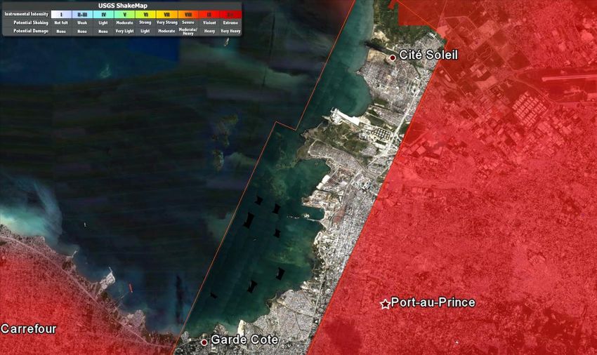
A virtual globe
Google Earth uses satellite and aerial images
combined with maps and Google’s
exceptional search capabilities to “put the
world's geographic information at your
fingertips.”(Brett Christensen, Nibbles & Bytes)
“Map of the Earth on steroids” (Karch, about.com)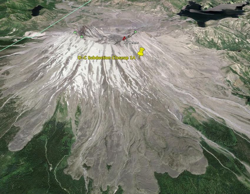
Commonly used as a visualization tool
Students find their house, apartment, school
Teacher shows location or example of what is
being studied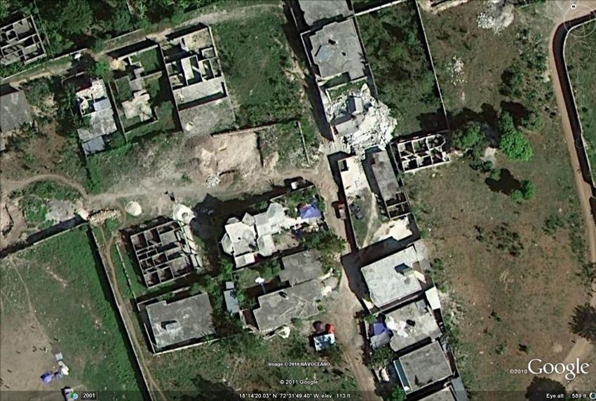
Science Education Program, Curry School of Education, University of Virginia
Commonly used as a visualization tool
But it can be so much more!
Make observations at different scales
Compare areas, features
Select layers with additional information
Timeline tool: change over time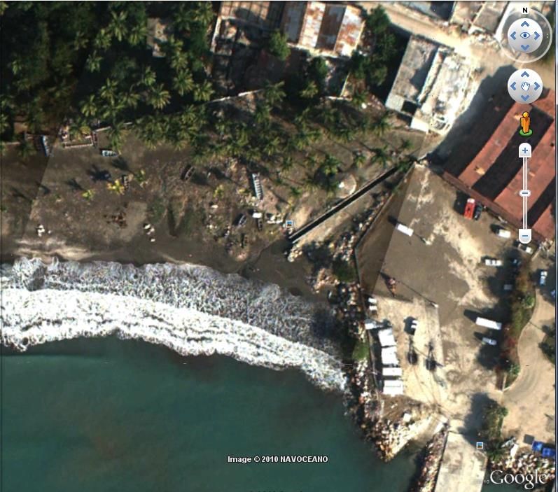
Active learning that emphasizes:
questioning
data analysis
critical thinking
Overall:
Students answer research question through
data analysis
(Bell, Smetana, & Binns, 2005)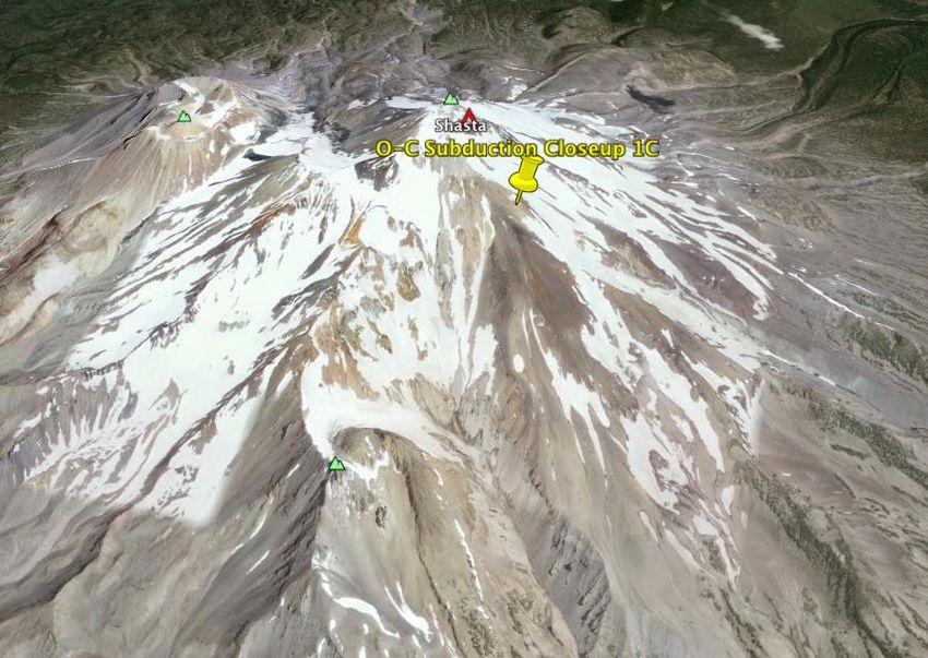
Inquiry Levels
How much information is given to the
student?
Level of Question? Methods? Solution?
Inquiry
1
2
3
4
(Bell, Smetana, & Binns, 2005)Technology use
Tech person commonly needs to install
Google Earth on school computers
Try it out on computers students will be using
Find out how many computers can be on
Internet at any one time
Be flexible
Have a backup plan Commonly level 2 inquiry
Why are tours likely to be level 2 inquiries?
Benefits
Direct students to important places
More time efficient
Focused on relevant content Start with level 2 inquiry tour
Whole class use of Google Earth first
Model and explicitly state how to navigate,
use relevant tools
Students can
choose where to start
take turns navigating
Provide a one-page Google Earth tools guide
before students work in pairs or individuallyBy Bridget Mulvey
How instruction has changed
Overview of how Todd used GE
Intro to Google Earth lesson
Tour on plate tectonics BEFORE lecture
Model how use tour
Tour debrief
Groups worked together to draw conclusions
GROUPS created the summary of characteristics
Clarification by other students, teachers
Look at images to support conclusionStudent Data Collection Table
Science Education Program, Curry School of Education, University of VirginiaData to Collect
Plate tectonic location (boundary type)
Name of Selected Site
General Topography
Volcanoes Common? (describe)
Earthquakes Common? (describe)
Generalizations: boundary characteristics
Discrepancies in the data, any questions that
emergeGuided Google Earth Tour
Sites
Orange pin: main site
Yellow pins: close-ups
Encourage students to visit both overview
and close-ups to collect data
**At least 1-2 stops should be done as a
whole class students learn how to use the
tools, make observations Whole class use of Google Earth first
Model and explicitly state how to navigate,
use relevant tools
Students can
choose where to start
take turns navigating
Provide a one-page Google Earth tools guide
before students work in pairs or individuallyWays to collect data
Topography
Drag cursor over the region to see changes in
elevation on land or below water
(recorded along very bottom of screen)
Check out place names
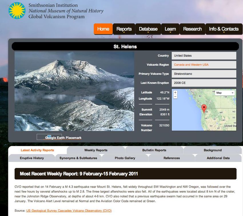
Volcanoes
Look for red triangles, click for more info
Within info box, can click to visit Smithsonian siteTour Stops
Student choice:
order
options for locations to visit
Stops not labeled by location name
students use map or globe to identify (increase
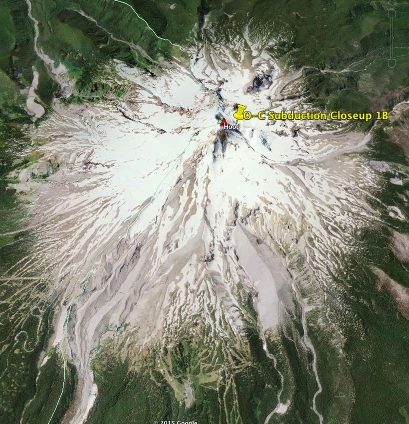
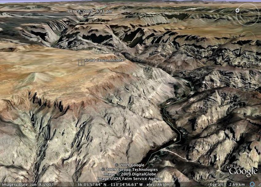
geographic awareness)Stop 1
Data
Plate tectonic location (boundary type):
Ocean-continent convergent: subduction zone
Name of Selected Site: Cascadia Subduction Zone
General Topography: Mountains, trench in ocean
Volcanoes Common? (describe)
Yes. See close-ups for details
Earthquakes Common? (describe) Some, shallow
Draw attention to this at some pointScience Education Program, Curry School of Education, University of Virginia
Ways to collect data
Earthquakes
Look for colored dots
Color indicates depth
Size indicates magnitude
Limitation: recent activity indicated
▪ Can turn on historical earthquakes layerElevation profile
Data
Plate tectonic location (boundary type):
Ocean-continent convergent: subduction zone
Name of Selected Site: Cascadia Subduction Zone
General Topography: Mountains, trench in ocean
Volcanoes Common? (describe) Yes. Stratovolcanoes
Earthquakes Common? (describe) Some, shallow
Draw attention to this at some pointStop 2, 3
Students visit at least two (three is better)
locations for each boundary type
identify trendsGeneralizations
Convergent Boundary: Ocean-Continent
Subduction zone
Evidence?
What was unexpected?
What might you want to investigate further?
What questions arose for you?Tour as springboard to student-
developed inquiry (level 4)
Consider what seems strange, doesn’t
completely make sense, or is intriguing.
Questions to investigation further?Students’ questions
Does volcano type change with increasing
distance from subduction zone boundary?
What might cause volcanoes to exist only on
one side of a subduction zone boundary?
What makes earthquake depth different at
different boundaries?
What happens when a volcano (with a glacier
on it) eruptsSupporting students
Cooperative learning roles
PI meeting to check on in all group’s progress,
answer questions for all groups at once
decreases group downtime waiting for helpAssessments
Formative assessment: check completed data
collection/analysis tables
Group presentations
Graphic representation and summary of
characteristics associated with plate
boundary types Increase students’ critical thinking about
data collection & analysis
Inquiry is more than following steps
developed by anotherNext lesson:
Students more interested
Relationship between magma % silica,
viscosity and volcano explosiveness
Higher % silica
Increase length, number of Si-O chains
Higher viscosity
More gases retained in magma
More explosive volcanic eruptions
More about volcano types Recent or historically important natural
disasters?
Volcanic eruption, Japan
Volcanic eruption, Iceland
Earthquake, Japan
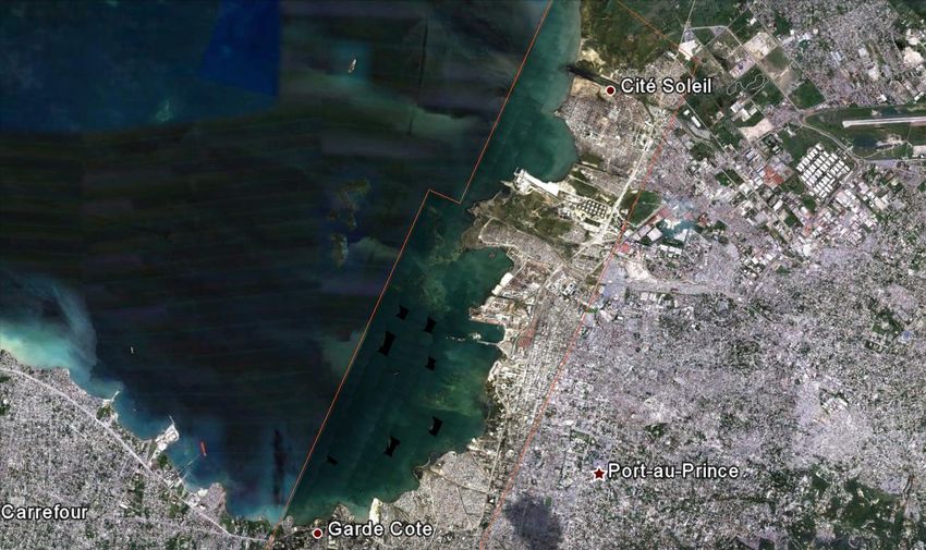
Earthquake, Virginia, USAEarthquakes Haiti
Jacmel, Haiti
Observations?

Potential impact
on organisms?
Port-au-Prince

 Effects on the
 Population of
 Haiti’s Capitol?
Shake Intensity Overlay

  Make Predictions,
  Then Explore!
Presidential Palace, Port-au-Prince

                             After earthquake

Before earthquake:
Historical imagery feature
Analysis Questions
How do volcanic eruptions and earthquakes
change Earth’s surface similarly? differently?
How do these changes in Earth’s surface
affect humans? How do humans affect the
ways and extent to which these impact
Earth’s surface?
What can humans do to mitigate the negative
impacts on Earth’s surface and organisms,
including humans?Haiti Earthquake: Just one example
How do other natural disasters affect Earth’s
surface?
Earth Systems Science: A professional development funded by the Ohio Board of Regents’ Improving Teacher Quality Program Valuable tool across the science curriculum
Environmental Science, Earth Science, Biology,
Life Science
Teacher- or student-centered
Don’t need to be an expert!
Start with our lessons or find lessons and/or tours
available online
With practice, you can modify other’s lessons or
make your own!
Earth Systems Science: A professional development funded by the Ohio Board of Regents’ Improving Teacher Quality Program See: Mulvey & Bell (2012)
Google Earth lessons
Teacher guides
Student worksheets
Google Earth tours
Teacher guides
Student worksheets
Additional Google Earth resource
descriptions/evaluations
Earth Systems Science: A professional development funded by the Ohio Board of Regents’ Improving Teacher Quality ProgramEarth Systems Science
“The content of this course turns out to be very
timely. I feel much better going into this year with
solid educational philosophy and support that
could lead to more meaningful science
instruction… Your ideas, support, and passion for
meaningful science instruction will be felt throughout
northeastern Ohio. Thanks for your dedication to ALL
of our kids.” -Teacher written reflection
“I felt very valued as a student in the classroom. The
instruction was tailored to our needs and our time
was used as wisely as possible.” -Teacher written reflection
Earth Systems Science: A professional development funded by the Ohio Board of Regents’ Improving Teacher Quality ProgramEarth Systems Science
Apply soon! 5 grad credits FREE!
When:
Summer: June 22-25, June 29-July 2 (8:30-4:30)
School Year: Aug. 22, Sept. 19, Oct. 24, Feb. 27, Apr. 9;
Makeup day: Mar. 5 (8:30-5)
Where: Kent State University, Kent campus
Focused on Gr. 7, 8, HS physical geology,
environmental science standards
For classroom, inclusion and resource
teachers; administrators
Earth Systems Science: A professional development funded by the Ohio Board of Regents’ Improving Teacher Quality ProgramEarth Systems Science at Kent State University. Funded by a grant from the Ohio Board of Regents’ Improving Teacher Quality Program. Mulvey & Curtis (Mills)
You can also read