Bulletin Autumn 2020 - Visualisations Geographical data stories - Royal Geographical Society
←
→
Page content transcription
If your browser does not render page correctly, please read the page content below
Bulletin
Autumn 2020
Inside
• News
• Our work

              Visualisations
              Geographical
               data stories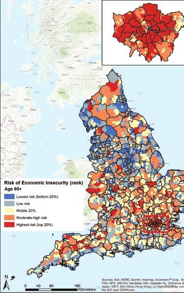
About the Society
Need to know
The Royal Geographical Society (with IBG) is the UK’s
learned society for geography and professional body for
geographers. We are also a membership organisation and
a registered charity.
The Society was founded in 1830 to advance geographical
science and this remains our core purpose. We achieve
this through supporting geographical research, education,
and fieldwork and expeditions, as well as by advocating
on behalf of the discipline and promoting geography to
public audiences.
We value our independence as well as the breadth of our
activities that support the understanding of the world’s people,
places and environments. Everyone with an enthusiasm for
geography, travel and exploration is welcome to join.
W www.rgs.org T @RGS_IBG E membership@rgs.org T 020 7591 3080

A message
© Panel 8 Photography

                                     From the Director

                        Today’s world is very different from the     including reductions in sources of external
                        one we lived in even five years ago,         project funding.
                        and the past few months have been
                                                                     The new strategy will be an evolution of
                        particularly unsettling. Climate change,
                                                                     the current one, with no radical change of
                        Brexit, racial inequality and a global
                                                                     direction. However, in addition to responding
                        pandemic are just a few of the prominent
                                                                     to external pressures brought about by the
                        issues facing our world, and geography
                                                                     ongoing COVID-19 pandemic, the refreshed
                        and geographers have a vital role to play
                                                                     strategy will also seek to articulate more
                        in addressing them.
                                                                     explicitly the Society’s core values and
                        The Society’s current five-year strategy     aims. This includes working towards being
                        was due for a refresh next year, but in      more socially representative, diverse
                        June Council agreed that the seismic         and inclusive, as well as becoming more
                        external changes we are facing warrant       environmentally sustainable and innovative.
                        bringing that process forward.
                                                                     Fellows and members can get in touch to
                        Over the summer I have therefore been        raise questions or share ideas about the role
                        reviewing, along with trustees and other     and nature of our strategy at any time via
                        stakeholders, the Society’s strategy. This   E director@rgs.org
                        has revealed exciting areas of opportunity
                        – working more closely with partners to
                        amplify our messages, for example. It has    Professor Joe Smith
                        also pinpointed areas of potential threat,   Director

                                                                                                                 1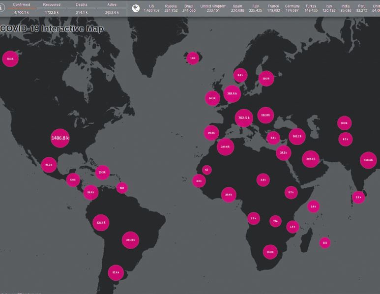
Society
News
COVID-19 and the Society
Due to the ongoing COVID-19 pandemic,
the Society’s building is currently closed
to everyone – including Fellows and
members – and staff are working remotely.
Given the current public health advice
on both the use of public transport and
the holding of events, we have decided
that the building will not re-open in any    Medals and awards
substantive way until Monday 2 November      This year our medals and awards
at the earliest.                             recognised 22 different people or
                                             organisations for their outstanding
However, we are keeping a close eye
                                             contributions to geographical research,
on official advice and if circumstances
                                             fieldwork, teaching and public engagement.
change significantly, elements of the
                                             The two Royal Medals were awarded to
building may re-open sooner. We will let
                                             Professor Heather Viles and Michael Jones,
you know if/when this happens.
                                             read our interviews with them on page 18.
We understand this will be disappointing
                                             Full details of all the recipients are
news, but the safety of our Fellows,
                                             on our website.
members and staff comes first. Thank
                                             W www.rgs.org/medalsandawards2020
you for your ongoing understanding and
support at this difficult time.

2
Council elections                            The 50 images and four films, which explore
Congratulations to our seven newest          the themes of people, place, nature,
members of Council, who were elected         changing forests, and climate change,
at the Annual General Meeting in June:       are available to view on our website.
Robert Lucas (Vice President: Expeditions
                                             The 2020 Earth Photo exhibition will take
and Fieldwork), Niall McCann (Councillor:
                                             place in our Pavilion at the Society between
Expeditions and Fieldwork), Philip Avery
                                             December and February. A touring exhibition
(Councillor: Education), Professor Peter
                                             will be on show at various Forestry England
Kraftl (Honorary Secretary: Research and
                                             sites later this year and into 2021.
Higher Education), Professor Steve Darby
                                             W www.rgs.org/earthphoto
(Councillor: Research and Higher
Education), Carol Lawson (Honorary           Agreement with the AGI
Treasurer) and David Lovell (Regions         We are delighted to have signed
Representative).                             an agreement continuing our strategic
                                             alliance with the Association for Geographic
We would like to thank our outgoing
                                             Information (AGI). This aims to further
members of Council for their hard work
                                             strengthen a range of activities for the
and dedication to the Society during their
                                             benefit of both geography professionals
terms of office.
                                             and businesses over the next two years,
Earth Photo shortlist revealed               including joint activities and providing
The shortlist for the 2020 Earth Photo       support, recognition and accreditation
competition has been announced.              for those working in the sector.

                                                                                       3
Education
News
School essay competition                        Scholars starting a new term
We are pleased to launch our second             We are excited to be supporting a new
joint School Essay Competition with the         cohort of 140 Scholars who are beginning
Financial Times. We are seeking thoughtful      their teacher training in September. We will
and well-argued responses from sixth form       be providing them with additional resources,
students on the geographical story behind       networking opportunities, and £17,000 tax
a chosen set of data about sustainability       free funding. We wish them all the best in
and climate change. Answers should use          starting the new school year.
data that helps tell a story based around the   W www.rgs.org/scholarships
COP-26 aims ‘to increase climate ambition,
                                                Congratulations
build resilience and lower emissions’.
                                                Congratulations to everyone who received
The deadline is 30 September.
                                                their GCSE and A Level results over the
W www.rgs.org/schoolessaycompetition
                                                summer, especially given the unusual
Excellence Awards                               circumstances. Whether you are going
Congratulations to the recipients of our 2019   on to further study or entering the world
Excellence Awards for their achievements        of work, we wish you all the best. If you
in the summer 2019 geography exams. The         are still deciding on whether to study
Awards recognise the pupils who achieve         geography for your A Levels or at university
the highest marks nationally and reflect        you can find out about the benefits of
their hard work and the support of their        studying the discipline on our website.
geography teachers.                             W www.rgs.org/choosegeography
W www.rgs.org/excellenceawards2019

4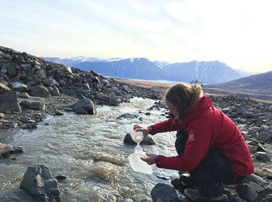
SA Agulhas II © Weddell Sea Expedition

                                         Resources                                     new resources to complement the Weddell
                                         Over the past few months we have been         Sea Expedition, including a virtual collector’s
                                         developing new resources to support           album and other interactive resources. We
                                         the teaching and learning of geography,       will share images of Antarctica on social
                                         including worksheets to use at home.          media, with a code to unlock information on
                                         We have been producing timely resources       a computer or tablet about who lives on the
                                         for teachers to share with parents and        frozen continent, its tourism, biodiversity
                                         students, including podcasts, case studies,   and how nations work together to protect
                                         articles and news roundups.                   this unique polar region. These new
                                                                                       resources will be launched in the autumn.
                                         With support from the Flotilla Foundation,
                                                                                       W www.rgs.org/wse
                                         we have also been developing a range of

                                                                                                                                    5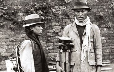
From the field
News
                                                                                     the highest health and safety and ethics

                                           Fieldwork in Greenland © Melissa Murphy
                                                                                     protocols for the research projects we
                                                                                     (or any of the organisations we work with)
                                                                                     support through the grants programme.
                                                                                     To date, with the generous support of our
                                                                                     donors, close to £190,000 of funding has
                                                                                     been allocated this year to support 39 field
                                                                                     research projects. Projects are planned to
                                                                                     take place in 28 countries spanning five
                                                                                     continents, and covering a range of topics,
COVID-19 and our grants programme                                                    including constraining river erosion rates
The global COVID-19 pandemic has                                                     and long-term evolution of volcanic island
significantly disrupted the fieldwork plans                                          landscapes in the Azores and Madeira
of many researchers, however the Society                                             archipelagos, investigating the place-based
is continuing to select projects and commit                                          geography of climate perception and its
funding for researchers who plan to go into                                          impacts on migration in Cambodia, and an
the field when it is safe and responsible                                            interdisciplinary study of grazing pressure
to do so. These grants will only be formally                                         in the Dhofar Mountains of Oman.
awarded, and funds will only be released
                                                                                     Application deadlines for the 2021 grants
to the recipient, when Government, FCO
                                                                                     programme begin in November 2020.
and in-country guidance is clear that it is
                                                                                     W www.rgs.org/grants
appropriate to do so. We continue to uphold

6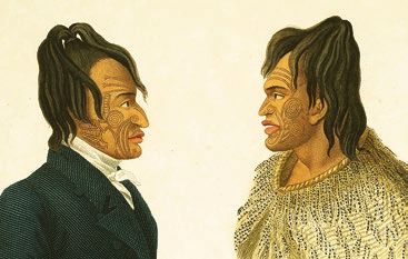
Research and higher education
News
Annual International Conference               Home SOS
We are pleased to announce that our           The latest addition
Annual International Conference 2022          to the RGS-IBG book
will be held at Newcastle University.         series, Home SOS:
Dr Sarah Evans, Research and Collections      Gender, Violence,
Engagement Manager at the Society, said:      and Survival in Crisis
“We are really delighted to be bringing the   Ordinary Cambodia,
annual conference to Newcastle in 2022.       shines a spotlight on
We know both the university and the city      domestic violence and
will be welcoming hosts, and we are keen      eviction in Cambodia.
for our delegates to see all that Newcastle   Written by Professor Katherine Brickell of
has to offer.”                                Royal Holloway, University of London, the
                                              book draws on over 15 years of fieldwork
Due to the COVID-19 pandemic, we have
                                              and over 300 interviews to highlight the
postponed our 2020 Annual International
                                              experiences of intimate violence and
Conference, which will now be held at the
                                              survival as told by Cambodian women.
Society between Tuesday 31 August and
Friday 3 September 2021. The conference       Home SOS is available to order now
will have the same theme Borders,             from the Wiley website, and Fellows and
borderlands and bordering and will be         members receive up to a 35% discount
chaired by Professor Uma Kothari.             when using the discount code listed in
W www.rgs.org/annualconference                the Members’ Area of the website.
                                              W www.rgs.org/login

                                                                                           7
WIREs turns 10                               Master’s accreditation
WIREs Climate Change, a Wiley journal        We are expanding our university
published in association with the Royal      programme accreditation scheme this
Meteorological Society and the Society,      autumn to include UK geography Master’s
is celebrating 10 years of publishing.       programmes. The Society already awards
Edited by Professor Mike Hulme of the        accreditation to high-quality undergraduate
University of Cambridge, WIREs offers        and integrated Master’s programmes,
a unique platform for exploring current      with geography degrees at over 50 UK
and emerging knowledge from diverse          universities now accredited. The expansion
research perspectives across a range of      of the scheme to include stand-alone
disciplines that develop our understanding   Master’s programmes will offer students and
of climate change.                           employers confidence that postgraduate
                                             geography programmes develop
Fellows and members of the Society
                                             workplace-ready graduates, with a depth
can access WIREs articles for free as
                                             of knowledge and expertise in a particular
part of their membership by logging in
                                             specialist area of geography.
to our website.
W www.rgs.org/login                          The first application deadline for Master’s
                                             accreditation is Wednesday 30 September.
                                             W www.rgs.org/accreditation

8
Geography Directions
Older age risk overall © University of Southampton
Geography Directions, the Society’s
blog linked to our scholarly journals,
showcases the importance of geography
and geographical insights to pressing
issues facing society and the environment.
Recently, content has focused on the
COVID-19 outbreak and the world after
the pandemic. Posts have considered
wastewater detection of outbreaks,
public transport and urban mobility,
decarbonisation and the new energy
order, the divided UK, Black deaths and
immobilities, quarantine urban ecologies,
and environmental activism in lockdown.
W blog.geographydirections.com
9Professional
News
Government Geography Profession Geospatial professional development
The Government Geography Profession The Geospatial Commission’s Geospatial
has become a standalone profession within Strategy 2020-2025, which was published
the Government Analysis Function and is in June, identifies enhancing capabilities,
now based at the Cabinet Office alongside skills and awareness as one of its
the Geospatial Commission. Initially four missions. The Society is therefore
established two and a half years ago, the continuing its work with employers and
Geographers in Government group now universities to strengthen links in the
has over 1,200 members across the public geospatial sector, highlighting the skills
sector. It supports members through events geography graduates bring to working
and professional training, and celebrates with spatial data, and encouraging more
the profession through awards. opportunities for work-based learning,
such as research projects and internships.
Head of the Government Geography
Profession, David Wood said: “I would We are also facilitating a trailblazer group
like to thank all those who have joined of employers, learning providers and others
the profession and worked with us to to develop and propose an apprenticeship
help us realise our vison. But there’s a lot that develops the specialist skills that are
more we want to do as a profession to in demand across a wide range of sectors.
support our members, set standards, and
work to embed geography at the heart of
government decision making.”
10Discussion between colleagues © Ellie Morris
Geography Professional launched The programme unlocks a range of benefits
We have launched a new programme and support including a recognised status
of support for professionals who are and membership of a peer group; a review of
committed to making an application your Continuing Professional Development
for Chartered Geographer (CGeog) (CPD) activities with advice on how to
accreditation. Geography Professional shape future CPD to support your CGeog
is open to anyone interested in gaining application; access to our mentoring
CGeog accreditation but is especially network; and personalised support
appropriate for early-career professionals throughout the application process.
looking for structured advice, support W www.rgs.org/geographyprofessional
and mentoring as they work towards
professional recognition.
11Events
Highlights
Autumn events programme Lowther Lodge is closed. Our speakers
This autumn all of the Society’s public this term include Professor Andy Tatem,
events will be held online. Our events Monisha Rajesh, Tim Jarvis, Hilary Bradt
include an evening marking the 200th and Sir Michael Palin.
anniversary of the first sighting of Antarctica
We are monitoring the public health advice
and the unique research conducted there
on large gatherings, events and use of
today, a topical discussion on the risks
public transport closely, and will resume
to the UK of a world that’s three degrees
physical Monday night lectures when it is
warmer, and the annual EGR Taylor lecture
safe and feasible to do so.
investigates the technical challenges
early modern European navigators faced Fellows and members can access the
on their vessels. live stream of our Monday night lectures
by logging in to the Members’ Area and
Our annual children’s lecture has been
accessing our live streaming page. If you
refreshed and will take place entirely online
haven’t previously logged in, you can set
with a host of experts sharing their stories
a password using the ‘forgotten password’
to enthuse and inform our young audience
link on the login page.
(and their accompanying grown-ups) about
the precious and extraordinary planet we You can find details of all of our events
call home. online at W www.rgs.org/events
We are continuing to live stream Monday
night lectures via our website while
12Geovisualisations
Insights with data
Geography has never been more
GB-Islands: Lewis and Harris © Paul Naylor and OS
important in helping us to understand
our rapidly changing world, and
geographers bring a critical perspective
and approach to the interpretation and
presentation of data. We have launched
a new series of images looking at the
power of maps and geographical data
visualisations for telling stories about
our world, from mapping the current
global COVID-19 pandemic and air
pollution levels in Europe, to showcasing
shifting voting patterns in the 2019
general election and predicting
Great Britain’s largest islands
gentrification patterns in London.
Paul Naylor, Cartographic Design Consultant
The series showcases how the skills at Ordnance Survey (OS), and the team
and techniques used to connect data on at OS created a visualisation showcasing
societies, economies and environments, Britain’s largest islands. Inspired by David
underpins good decision-making and Garcia’s data visualisation of the Philippines,
improves understanding of our world. the team used a range of OS data to create
rich, detailed terrain maps of 82 English,
Scottish and Welsh islands.
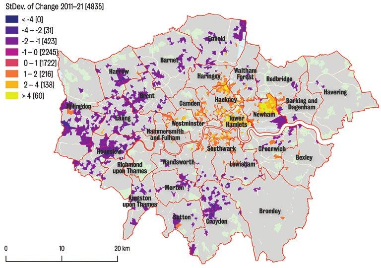
13Gentrification in London
Dr Jonathan Reades, Senior Lecturer in
Quantitative Human Geography at King’s
College London, created a visualisation
which applies data science and machine
learning methods to gentrification. Using
data from the 2001 and 2011 censuses,
Jonathan used open source software
and a machine learning model to predict
demographic change throughout London
As Paul said: “OS has a range of rich and
by 2021.
detailed geographic datasets which we
were able to make use of and give us Jonathan said: “Most of the work that has
some amazing end visuals. It has become been done in the UK on gentrification has
a really popular image that has inspired taken a qualitative approach. But if we
a lot of people across social media to try want to look at prediction and think about
and visit every island. Hopefully some which areas are going to be impacted
people have achieved some, or all, of this next, then we need to turn to a different
goal, but because of the current situation set of methods. That’s where machine
with regards to COVID-19 I’m hoping that it learning comes in. What I really like about
might provide people with something nice this approach is that it allows us to get an
to look at whilst they are staying at home idea of the size of the problem, at the scale
and keeping safe.” of an entire region.”
1415 Gentrification in London © Jon Reades
COVID-19 data on 18.05.20 © Powered by Maploom, Data Sources © Johns Hopkins University, © ECDC, © Public Health England, © OpenStreetMap contributors

                                                                                                                                                         16
Mapping COVID-19
The coronavirus pandemic is fundamentally
geographical, with the global crisis affecting
us all. It is presenting huge challenges for
health care providers who need to work
out how the virus is spreading and where
best to target their resources. Maploom,
a mapping, analytics and visualisation
company, created an open-access online
interactive visualisation which displays the
evolution of the pandemic and allows users
to compare and contrast data from different in the public domain. The interactive maps
countries through interactive maps, and dashboards offer a more flexible
dashboards and automatically generated approach and enable the latest situation
reports. to be presented. The fact that the data
also form an ongoing record of the virus
Andy Murdock CGeog (GIS), Managing
and its evolution means that we are able
Director of Maploom, said: “The COVID-19
to explore other visualisations through
pandemic is a fast moving, dynamic
interactive charts and recent trends.”
situation and so standalone maps are only
of use for a limited time. When we created To see the current range of our
the detailed specific country reports, there geovisualisations, visit our website.
was not really anything else like it available W www.rgs.org/geovisualisation
17Medals and awards
2020 Royal Medal recipients
This year our medals and awards
© Mim Saxl
recognised 22 different people and
organisations for their extraordinary
achievements in geographical
research, fieldwork, teaching, and
public engagement. We caught up
with this year’s Royal Medallists,
Professor Heather Viles and Michael
Jones to find out more about their
achievements, maps and the future Professor Heather Viles
of geography. Founder’s Medal
What are you most proud of in your
career so far? That’s a difficult question,
but I’m certainly very proud of the wonderful
team of researchers and students that I’ve
developed working around me. I’m also
very proud of the fact that my research has
contributed, even in a small way, to solving
some important problems for heritage
conservation.
18During your career, how has
biogeomorphology, and geography
more widely, changed? One of the
biggest changes has been the explosion
of technology which now supports the
research that we do. I couldn’t do any of
my field research without the many gadgets
that have been developed. Also I think
geography, and biogeomorphology, have
been proven to be really useful subjects, Michael Jones
which address some of the very biggest Patron’s Medal
challenges the world faces today. What do you consider to be your
greatest achievement and what are you
Where do you think the discipline is
most proud of in your work? Hopefully
going in the future? I’d like to suggest
my greatest achievement will be the next
that geography is like a chameleon, that
one. This is a core aspiration of life.
it changes its appearance to fit in with its
surroundings, whilst keeping at its heart The work cited by the Society in awarding
what it really believes in and is good at. me the Patron’s Medal has touched the
I think geography will continue to be most people and I am proud of that. It
the subject to go to for anybody who’s changed how we understand our world
interested in how humans interact with by answering questions as a personal
their environment. conversation with the planet. Google Earth
19answers with imagery, in 3D, on a globe How do you think mapping, maps
that is science fiction’s ultimate map room. and our use of them will change in
I am proud of the dream, the invention the future? Like everything, mapping
that makes it possible, and everyone and will become better at what it already
everything involved. does: precise capture of location data
using imagery, more perfect geospatial
During your career how has cartography
computation, and better imagery in
and mapping changed? Maps have
terms of resolution and update frequency
become personal and conversational:
and advanced sensors including
your map is created from answers to
synthetic aperture radar (SAR) and
your questions, a personal assistant
hyperspectral sensors.
customised by our tastes and habits. It is
quite a change from mapping data evolving Maps for people to look at will be less
at a geological or glacial pace to today’s frequent than maps as a means of
minute-by-minute health, safety, and traffic data processing. Many mobile phone
news. Today we’re all part of map making. applications rely on location information.
Our travels help characterise roads as This is ‘maps for computers’. Self-driving
congested and slow, our presence votes cars and trucks need ‘maps for robots’.
for locations as popular, and because of the Augmented Reality needs ‘maps for
web, anyone can curate a map visible to artificial intelligence’. This is all mapping.
people worldwide. So it’s not just a billion It is the same science but not intended
people using a map, it is a billion people for human eyes or interpretation.
making a map through their daily lives.
20Exhibitions
Visit them online
The Society’s extensive Collections
Natives of Stanley’s party, Cape Town © RGS-IBG
comprise over two million artefacts,
archival items, books, maps, films
and photographs. Together they
form a valuable source of primary
archival materials that allow us to
ask questions about representation
and start to tell the stories that
haven’t yet been told around themes
of gender, race, ethnicity, indigeneity
Hidden Histories
and class. As part of our work to make
Exploration has always been a
diverse geographical histories more
fundamentally collective and shared
accessible, we’re starting to put some
experience. Sometimes hidden,
of our Collections-based exhibitions
sometimes visible, the role of local people
online so you can discover the stories
in the history of exploration and travel
for yourself.
deserves to be much better known.
W www.rgs.org/online-exhibitions In many different parts of the world, from
the Arctic to Asia, and from Africa to the
Americas, European explorers relied
on local knowledge and support from
intermediaries such as interpreters and
guides, which is often overlooked.
21Chefs de la Nouvelle-Zélande © RGS-IBG
Mount Everest in morning light © RGS-IBG
This online exhibition recognises Everest – A Reconnaissance
and celebrates the collaboration and The 1921 British Mount Everest
co-production of a selection of expeditions. Reconnaissance Expedition mapped
Drawing on the AHRC-funded project approach routes to the mountain and
Hidden Histories of Exploration by climbed to 23,000 feet, laying plans for
Professor Felix Driver and Dr Lowri Jones, future attempts and providing some of
which featured in a major exhibition at the first, and finest, close-range images
the Society in 2009, Hidden Histories of Everest.
contains numerous images of exploration
Photography was always an important
since 1800 and explores the work,
component of Mount Everest expeditions.
the documentation and the ethics of
From the first expedition onward, cameras
these expeditions.
and the paraphernalia required were
22Two Sherpa photographic porters © RGS-IBG
Porters climbing along a ridge © RGS-IBG
part of the equipment factored into the each saw and recorded their time on the
logistics of climbing the mountain. For mountain. The photographs also depict
the porters it was certainly a heavy load, the overlooked but indispensable role that
from cameras and lenses to glass plate the Sherpas played during the expeditions,
negatives, tripods and chemicals. The and are an important source of historical
early expeditions took all that was needed documentation for the Tibetan and Nepali
both to expose and to develop pictures peoples, as well as being a valuable tool
on the mountain. for wider research.
The 1921 photographs were taken by a This exhibition showcases a selection of
disparate group of men, from scientists to platinum prints, available to purchase, made
climbers, doctors of medicine to surveyors from the newly digitised glass and celluloid
and there are fascinating differences in how negatives of the 1921 Everest expedition.
23Membership
Thank you for your support
Over the last few months, Society
staff have worked hard to adapt our
services, events and resources so that
you can continue to enjoy the benefits
of membership.
It may still be a few months until we’re able
to offer face to face events again, but our
online training and events programme,
including Monday night lectures, is in full
swing. And with physical conferences,
meetings and networking all postponed, we
have been finding other ways to support
Fellows and members, for example by
providing online advice and resources as
well as spaces for digital meetings.
Without your support for the Society, our
and supporting geography teachers,
wide-ranging charitable work to support
providing grants for field research, and
geographers and advance geography
contributing to policy consultations.
would not be possible. Throughout the
COVID-19 pandemic we have continued Thank you for your ongoing support during
our work recruiting Teacher Training Scholars what is a difficult time for everyone.
24Nominate a Fellow
Fellowship
If you know someone who would benefit
from being part of a vibrant community of
geographers, why not nominate them for
Fellowship of the Society?
Fellowship is open to anyone over the age
of 21 who can bring geographical or allied
subject expertise to the Society – this
could be from an academic, educational
or professional background.
Our Fellows bring a wide range of
experiences to the organisation and are
vital to the Society’s mission to advance
geography. They enable us to achieve
so much more as a result of their
expertise, knowledge and enthusiasm
for the discipline.
So nominate a friend for Fellowship today
– encourage their passion for geography
and support our work.
W www.rgs.org/fellowship
25How to
find us
Entrance is on Exhibition Road The Society is the learned society and professional body for
geography. We support and promote geographical research,
Nearest Tube station South Kensington education, fieldwork and expeditions, and geography in
society; we also advise on policy issues. The Society has
Royal Geographical Society (with IBG) substantial Collections available to all.
1 Kensington Gore London SW7 2AR
Corporate Partners
T +44 (0)20 7591 3000
E info@rgs.org
W www.rgs.org
Cover image Great Britain’s islands © Paul Naylor and OSYou can also read