Caliper Lake Preliminary Management Plan - Legislative ...
←
→
Page content transcription
If your browser does not render page correctly, please read the page content below
Caliper Lake Preliminary Management Plan
© 2015, Queen’s Printer for Ontario

                Printed in Ontario, Canada

                Cover photo: Camping at Caliper Lake

                Cover photo taken by: Barry Wojciechowski

                Additional copies of this publication can be obtained from the Ministry of
                Natural Resources and Forestry from the Caliper Lake Provincial Park
                office:

                Caliper Lake Provincial Park
                P.O. Box 5080, 808 Robertson Street
                Kenora, ON
                P9N 3X9

                Telephone: (807) 468-2669

62883 (print) 62884 (PDF)
(0.1k P.R., 15 03 01)
ISBN 978-1-4606-5075-2 (Print)
ISBN 978-1-4606-5076-9 (PDF)

Cette publication hautement spécialisée Caliper Lake Preliminary Park Management
Plan n’est disponible qu’en Anglais en vertu du Règlement 411/97 qui en exempte
l’application de la Loi sur les services en français. Pour obtenir de l’aide en français,
veuillez communiquer avec Michele Proulx au ministère des Richesses naturelles et
des Forêts: michele.proulx@ontario.ca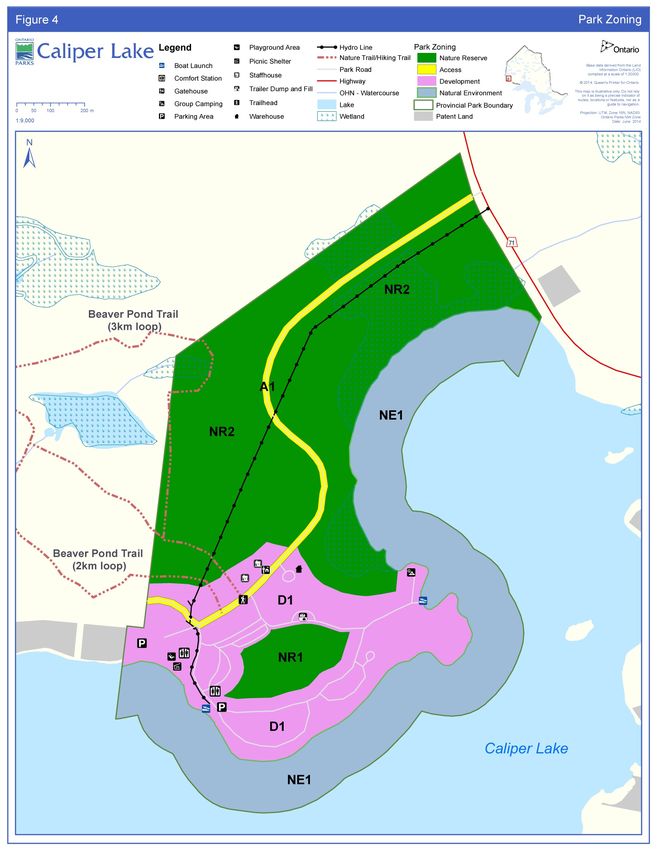
Examination and Adjustment of Management Direction
The following table serves as a record of adjustments and examinations of management
direction.

Approval    Examination or Type of        Examination          List of Supporting
  Date          Adjustment               Outcome (where        Documents (do not
                                            applicable)             hyperlink)
             Examination                 Status quo           e.g., amendment
             Administrative update       Administrative       form, update form,
             Amendment                   Update               secondary plan,
             Secondary Plan              Amendment            examination
                                         Replacement          confirmation
                                                              statement

                                         2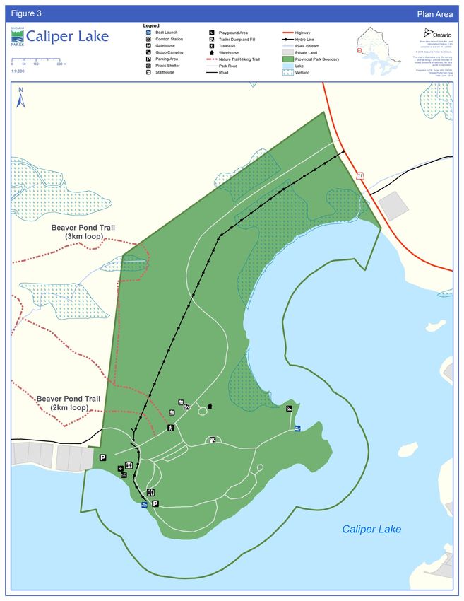
Opportunity to Comment
            Caliper Lake Provincial Park Preliminary Management Plan

Ontario Parks, Northwest Zone is preparing a park management plan for Caliper Lake
Provincial Park as part of a multi-staged planning process.

After careful consideration of related planning information, this document outlines
Ontario Parks’ draft site specific management policies for the provincial park.

For ease of review this preliminary park management plan is worded in the style of an
approved park management plan. Note however that this document contains proposed
site objectives, policies and actions related to managing the protected area’s natural,
cultural and recreational values. The approved park management plan will guide the
management of the provincial park over the next 20 years.

You are invited to review and comment on the preliminary management plan for a
period of 45 days following the release of this document. An open house in the
community of Sioux Narrows – Nestor Falls is being planned for April 30, 2015.
Members of the planning team will be available to discuss the planning process and
preliminary management direction.

To make your submission effective, list the topic/s you wish to discuss and briefly state
your reasons for agreeing or disagreeing with the proposed management direction. You
may also make suggestions or comments on other topics important to you.
Respondents wanting their commercial business information to remain private should
mark those parts of their submissions ‘confidential’.

When preparing final plans, the Ministry of Natural Resources and Forestry will consider
all submissions on this preliminary management plan.

All comments regarding the preliminary park management plan should be made by
June 1, 2015 and submitted to:

Matthew Yeo
Park Superintendent                            Tel: (807) 468-2669
Caliper Lake Provincial Park                   Fax: (807) 468-2737
P.O. Box 5080, 808 Robertson Street            Email: matthew.yeo@ontario.ca
Kenora ON P9N 3X9

                                           3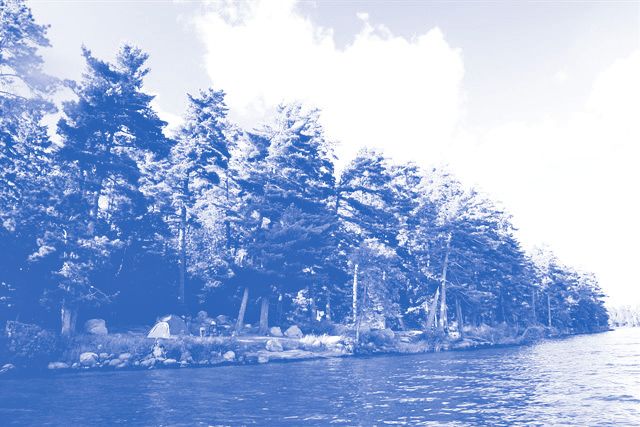
TABLE OF CONTENTS

                                                                                                                                                 Page
Examination and Adjustment of Management Direction ....................................................... 2
LIST OF FIGURES .................................................................................................................... 6
1   CONTEXT .......................................................................................................................... 7
    1.1     Provincial Parks and Conservation Reserves Act ....................................................................... 7
    1.2     Aboriginal Communities ............................................................................................................... 7
    1.3     Planning Context ......................................................................................................................... 7
    1.4     Involvement.................................................................................................................................. 9
       1.4.1 Summary and Results of Aboriginal Involvement ................................................................... 9
       1.4.2 Summary and Results of Public Involvement.......................................................................... 9
    1.5     Summary of Significant Management Topics .............................................................................. 9
2       Contexte ...........................................................................................................................10
    2.1    Loi de 2006 sur les parcs provinciaux et les réserves de conservation .................................... 10
    2.2    Prise en compte de la Déclaration sur les valeurs environnementales du ministère des
    Richesses naturelles et des Forêts produite conformément à la Charte des droits environnementaux 10
    2.3    Contexte de la planification........................................................................................................ 10
    2.4    Peuples autochtones ................................................................................................................. 11
    2.5    INTRODUCTION ....................................................................................................................... 12
    2.6    RÉSUMÉ DES POINTS IMPORTANTS (sans ordre particulier) ............................................... 13
    2.7    Politiques d’aménagement ........................................................................................................ 13
    2.8    Zones d’aménagements ............................................................................................................ 13
    2.9    Priorités de mise en œuvre........................................................................................................ 14
3       INTRODUCTION ...............................................................................................................14
4       PARK CLASSIFICATION .................................................................................................15
5       PURPOSE.........................................................................................................................15
5       VISION ..............................................................................................................................15
6       OBJECTIVES ...................................................................................................................15
    6.1      Protection Objective ................................................................................................................... 16
       6.1.1 Life Sciences ......................................................................................................................... 16
          6.1.1.1    Representation Analysis ............................................................................................... 16
          6.1.1.2    Vegetation Communities............................................................................................... 17
          6.1.1.1    Fauna ............................................................................................................................ 17
       6.1.2 Earth Sciences ...................................................................................................................... 19
       6.1.3 Cultural Heritage Resources ................................................................................................. 19
    6.2      Recreation Objective ................................................................................................................. 19
    6.3      Heritage Appreciation Objective ................................................................................................ 20
7       BOUNDARY .....................................................................................................................20
8       ADJACENT LAND USES ................................................................................................21
9       PARK POLICIES ..............................................................................................................21
    9.1      Industrial and Commercial Uses ................................................................................................ 21
    9.2      Adaptive Management ............................................................................................................... 23
    9.3      Resource Management Policies ................................................................................................ 23
       9.3.1 Land Management ................................................................................................................ 23
       9.3.2 Water Management ............................................................................................................... 24
       9.3.3 Alien and Invasive Species ................................................................................................... 24
       9.3.4 Insects and Diseases ............................................................................................................ 24
       9.3.5 Forest Fire Management ....................................................................................................... 25
          9.3.5.1     Fire Response .............................................................................................................. 25
          9.3.5.2     Additional Fire Direction................................................................................................ 26
       9.3.6 Species at Risk (SAR) ........................................................................................................... 26
       9.3.7 Vegetation Management ....................................................................................................... 26
       9.3.8 Wildlife Management ............................................................................................................. 27

                                                                            5
9.3.9 Fisheries Management .......................................................................................................... 27
9.3.10 Cultural Heritage Resources Management ....................................................................... 28
9.3.11 Research ........................................................................................................................... 28
9.3.12 Inventory and Monitoring .................................................................................................. 29
9.4 Recreation Management Policies .............................................................................................. 29
9.4.1 Hunting .................................................................................................................................. 29
9.4.2 Recreational Fishing .............................................................................................................. 29
9.4.3 Mechanized Travel ................................................................................................................ 30
9.4.4 Trails ...................................................................................................................................... 30
9.4.5 Other Recreational Uses ....................................................................................................... 30
9.4.6 Services for Visitors ............................................................................................................... 31
9.5 Operations Policies .................................................................................................................... 31
9.5.1 Natural Heritage Education (NHE) ........................................................................................ 31
9.5.1.1 Information .................................................................................................................... 31
9.5.1.2 Park Interpretation ........................................................................................................ 32
9.5.1.3 Outdoor Recreation Programs ...................................................................................... 32
9.6 Marketing and Communications Policies ................................................................................... 32
9.7 Development Policies ................................................................................................................ 32
9.7.1 Internal Roads, Parking Areas, Maintenance and Administrative Areas .............................. 32
9.7.2 Campground, Day-Use Areas and Trails .............................................................................. 33
10 ZONING AND ZONE MANAGEMENT POLICIES ...........................................................34
10.1 Development Zone .................................................................................................................... 34
10.1.1 D-1 – Park Road, Campground & Day-Use Area (29.5 ha) .............................................. 34
10.2 Access Zone .............................................................................................................................. 34
10.2.1 A -1 - Park Road (4 ha) ..................................................................................................... 34
10.3 Natural Environment Zone ......................................................................................................... 35
10.3.1 NE -1 – Caliper Lake (44 ha) ............................................................................................ 35
10.4 Nature Reserve Zoning.............................................................................................................. 35
10.4.1 NR – 1 - Mature Red and White Pine (5 ha) ..................................................................... 35
10.4.1 NR – 2 - Mixed Forest (65 ha) .......................................................................................... 35
11 IMPLEMENTATION PRIORITIES .....................................................................................37
12 EXAMINATION AND ADJUSTMENT OF MANAGEMENT DIRECTION...........................37
13 REFERENCES ..................................................................................................................38
13.1 PLANT ....................................................................................................................................... 41
13.1.1 Tree ................................................................................................................................... 41
13.1.2 Shrub & Forb ..................................................................................................................... 41
13.2 ANIMAL...................................................................................................................................... 41
13.2.1 Bird .................................................................................................................................... 41
13.2.2 Fish.................................................................................................................................... 41
13.2.3 Mammal ............................................................................................................................ 41
13.2.4 Insect ................................................................................................................................. 41
13.3 BACTERIA ................................................................................................................................. 41
13.4 FUNGI ........................................................................................................................................ 41
LIST OF FIGURES
Figure 1 – Regional Setting........................................................................................................................... 8
Figure 2 - Vegetation Communities and Critical L/V Associations.............................................................. 16
Figure 3 - Plan Area .................................................................................................................................... 20
Figure 4 - Proposed Zoning .......................................................................... ..............................................36
61 CONTEXT
1.1 Provincial Parks and Conservation Reserves Act
The Provincial Parks and Conservation Reserves Act, 2006 (PPCRA) is the legislation
that guides the planning and management of the protected areas system. The PPCRA
has two specific principles that guide all aspects of planning and management of
Ontario’s system of provincial parks and conservation reserves:
o Maintenance of ecological integrity shall be the first priority and the restoration of
ecological integrity shall be considered
o Opportunities for consultation shall be provided (2006, c. 12, s. 3).
1.2 Aboriginal Communities
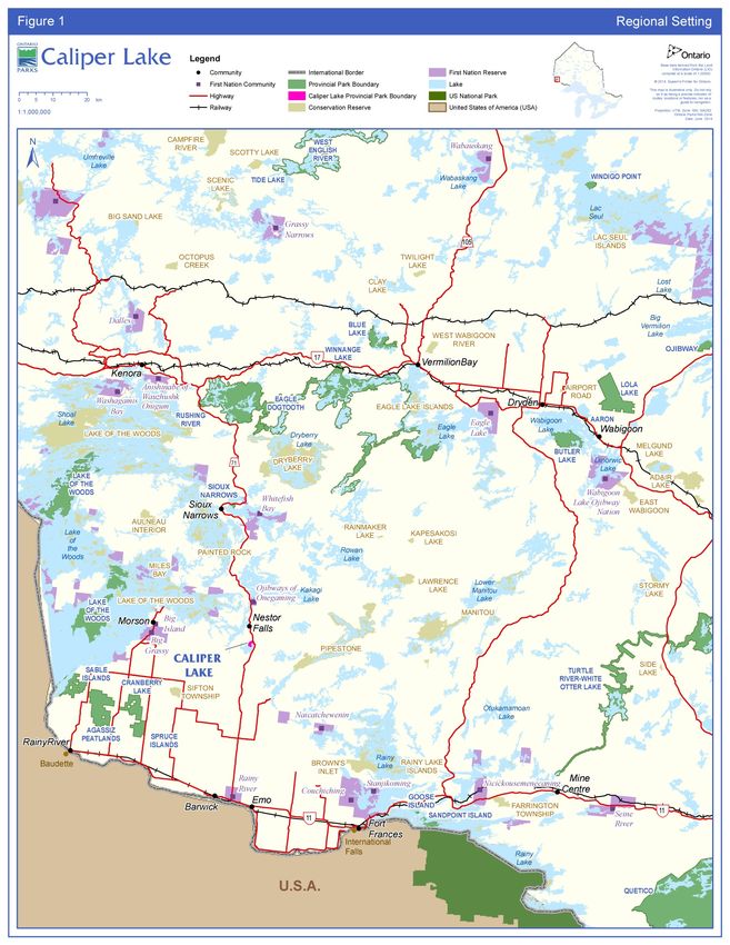
Caliper Lake Provincial Park lies within the Treaty 3 Area. Treaty 3 includes a large area
that extends from Lake Winnipeg (Manitoba) in the west to Dog Lake in the east and
includes Lake of the Woods, Red Lake and Lac Seul. Treaty 3 is comprised of 28 First
Nations in northwestern Ontario and southeastern Manitoba.
There are several nearby Aboriginal communities including Ojibways of Onegaming
(Sabaskong), Anishinaabeg of Naongashiing (Big Island), Big Grassy River,
Naotkamegwanning (Whitefish Bay), Anishinabe of Wauzhushk Onigum (Rat Portage),
Northwest Angle #37, Northwest Angle #33, Shoal Lake #40, Iskatewizaagegan # 39
Independent First Nation, Ochiichagwe’babigo’ining (Dalles), Rainy River, Couchiching,
Naicatchewenin, Obashkaandagaang (Washagamis Bay), Mitaanjigamiing (formerly
Stanjikoming), Grassy Narrows, Wabauskang, Wabaseemoong, Eagle Lake and
Wabigoon Lake (Figure 1).
In addition, the Kenora, Northwest and Sunset Country Métis Councils are located
within this geographic area.
Aboriginal interests and use within Caliper Lake Provincial Park are not completely
known.
1.3 Planning Context
This preliminary park management plan has been prepared consistent with direction
contained in Our Sustainable Future: A Renewed Call to Action, Ministry of Natural
Resources Strategic Directions (OMNR 2011a) and Biodiversity: It’s In Our Nature
(2012-2020), the Ontario Government’s plan to conserve biodiversity.
The Caliper Lake Preliminary Park Management Plan has been developed in
accordance with the PPCRA, Ontario Provincial Parks Planning and Management
Policies (OMNR 1992) and Ontario’s Living Legacy Land Use Strategy (OMNR 1999)).
All activities undertaken in Caliper Lake Provincial Park must comply with A Class
Environmental Assessment for Provincial Parks and Conservation Reserves (Class EA-
PPCR), where applicable (OMNR 2005).
78
1.4 Involvement
      1.4.1 Summary and Results of Aboriginal Involvement

Twenty nearby Aboriginal communities were contacted about Phase 1 (invitation to
participate and background information) in September 2007 and again in August 2009.
Two communities requested planning materials. These materials were provided.

During Phase 1, one community requested an opportunity for involvement, but no
formal meetings have occurred. The park superintendent made a presentation in
September 2009 to elders of another community upon request.

      1.4.2 Summary and Results of Public Involvement

Public involvement is an important part of the Caliper Lake park management planning
process. The following provides a summary of the opportunities made available for the
public to become involved in the planning process and a summary of the results.

   o Phase 1 - Invitation to participate; review the terms of reference and
     background information file

The approved terms of reference document and the background information file were
made available for the public to review on September 6th, 2007 and again on January
9th, 2008 through direct notices and EBR environmental registry (ER) postings. Of the
four comments received, no comments or suggestions were concerning the content of
the plan. Several requests to be added to the project mailing list were also received.

   o Phase 2 - Preliminary Park Management Plan (current phase)

The public and Aboriginal communities will have an opportunity to review the
preliminary management plan for a minimum period of 45 days through a notice on the
ER after its formal release. This will allow interested participants to comment on
proposals in the plan.

   o Phase 3 – Final Park Management Plan

Using the input received on the preliminary plan, a final management plan will be
prepared and made available to the public.

1.5 Summary of Significant Management Topics
No significant management concerns have been raised to date.

                                          9
2 Contexte
2.1 Loi de 2006 sur les parcs provinciaux et les réserves de
conservation
La Loi de 2006 sur les parcs provinciaux et les réserves de conservation guide la
planification et la gestion du réseau des zones protégées. Deux des principes de cette
loi régissent tous les aspects de la planification et de la gestion du réseau des parcs
provinciaux et des réserves de conservation de l’Ontario:
Le maintien de l’intégrité écologique est la priorité principale et le
rétablissement de l’intégrité écologique est pris en considération.
Des possibilités de consultation sont offertes. (2006, chap. 12, art. 3.)
2.2 Prise en compte de la Déclaration sur les valeurs
environnementales du ministère des Richesses naturelles et des
Forêts produite conformément à la Charte des droits
environnementaux
La Déclaration sur les valeurs environnementales du ministère des Richesses
naturelles et des Forêts produite conformément à la Charte des droits
environnementaux décrit comment tenir compte des objectifs de la Charte dans les
décisions du ministère qui pourraient avoir des répercussions importantes sur
l'environnement. Ces décisions incluent celles prises dans le cadre de la préparation
des orientations de la gestion d’une zone protégée.
La Déclaration du ministère a été prise en compte tout au long du processus de
planification. Les orientations de la gestion du parc provincial Caliper Lake serviront les
objectifs de la gestion des ressources de l’Ontario dans la perspective de la durabilité
environnementale.
2.3 Contexte de la planification
Ce plan préliminaire de gestion du parc a été préparé conformément aux orientations
énoncées dans Notre avenir durable : un appel à l’action renouvelé, ministère des
Richesses naturelles (2011) et La biodiversité, c’est dans notre nature – Plan du
gouvernement de l’Ontario pour conserver la biodiversité, 2012-2020 (2012).
Le plan préliminaire de gestion du parc Caliper Lake a été préparé conformément, entre
autres, aux dispositions de la Loi de 2006 sur les parcs provinciaux et les réserves de
conservation.
Toutes les activités entreprises dans le parc provincial Caliper Lake doivent être
conformes à l’Évaluation environnementale de portée générale relative aux parcs
provinciaux et aux réserves de conservation (EE-PPRC), le cas échéant (2005).
La vision du ministère est le « développement durable » et sa mission est d’assurer la
« durabilité écologique ». Le programme de Parcs Ontario vise principalement à offrir
10un « environnement naturel sain aux Ontariennes et aux Ontariens », mais apporte
aussi une contribution à d’autres éléments stratégiques. Le mandat du ministère
concernant Parcs Ontario est d’assurer la prestation du programme des parcs et
réserves de conservation de l’Ontario, dont la protection et la gestion des milieux
naturels, culturels et récréatifs d’importance à l’échelle provinciale, les activités des
parcs provinciaux, la création de créneaux touristiques et l’éducation sur le patrimoine
naturel, la planification et la gestion des parcs et zones protégées, le leadership
stratégique pour les réserves de conservation ainsi que le suivi, la vérification et
l’établissement de rapports publics sur les parcs et zones protégées de l’Ontario.
Ce document a aussi été préparé conformément aux orientations exposées dans
Protéger la biodiversité pour assurer l’avenir : Stratégie de la biodiversité de l’Ontario
(2005) et dans le Manuel de planification des zones protégées (2009). Parcs Ontario
appuie autant le premier objectif « protéger la diversité du capital génétique, des
espèces et des écosystèmes en Ontario » que le deuxième « utiliser et développer de
manière durable les ressources biologiques de l’Ontario, et faire en sorte que la
population ontarienne puisse jouir des avantages que cela crée ». En particulier, le parc
provincial Caliper Lake sera géré de manière à protéger les espèces à risque et leurs
habitats conformément à la Loi de 2007 sur les espèces en voie de disparition et ses
règlements.
2.4 Peuples autochtones
Les Premières Nations des Ojibways d’Onegaming (Sabaskong), Anishinaabeg de
Naongashiing (Big Island), Big Grassy River, Naotkamegwanning (Whitefish Bay),
Anishinabe de Wauzhushk Onigum (Rat Portage), Northwest Angle no 37, Northwest
Angle #33, Shoal Lake no 40, Iskatewizaagegan no 39 Independent First Nation,
Ochiichagwe’babigo’ining (Dalles), Rainy River, Couchiching, Naicatchewenin,
Obashkaandagaang (Washagamis Bay), Stanjikoming, Grassy Narrows, Wabauskang,
Wabaseemoong, Eagle Lake, et de Wabigoon Lake se trouvent dans les environs du
parc. Le parc provincial Caliper Lake fait partie de la zone d’utilisation traditionnelle de
ces communautés autochtones et, pour le moment, ne fait l’objet d’aucune
revendication territoriale. De plus, les bureaux de Kenora et de Sunset Country de la
Nation des Métis de l’Ontario se trouvent aussi dans les environs du parc.
Le parc provincial Caliper Lake chevauche des terres et eaux traditionnelles de ces
communautés autochtones qui y chassent, posent des pièges, pêchent, se regroupent
et voyagent.
Conscient des caractéristiques archéologiques autochtones situées dans la région,
Parcs Ontario apportera une attention spéciale aux intérêts particuliers des Premières
Nations locales. Le respect et la protection des caractéristiques archéologiques et
culturelles font partie intégrante de ce plan de gestion du parc. Les Premières Nations
seront consultées sur des points qui les concernent pendant la mise en œuvre de ce
plan.
112.5 INTRODUCTION
Le parc provincial Caliper Lake, de 147 ha, est classé dans la catégorie « parc de
loisirs ». Il a été réglementé en 1960 sous le nom « Caliper Lake Provincial Camp and
Picnic Grounds ». On accède au parc, situé sur la rive du lac Caliper, par la route 71.
En 1997, le MRN a annoncé un programme complet de planification de l’aménagement
du territoire, Des terres pour la vie, dont un des objectifs était de compléter le réseau
des parcs et zones protégées de l’Ontario dans la région visée par la planification. C’est
ainsi que beaucoup de nouvelles zones protégées recommandées ont été proposées et
examinées dans le cadre d’un programme de consultation publique mené dans tout
l’Ontario. Le fruit du programme Des terres pour la vie a été la Stratégie
d’aménagement du Patrimoine vital de l’Ontario publiée en juillet 1999.
La Stratégie d’aménagement a aussi entraîné des modifications aux politiques régissant
l’utilisation des ressources et les usages récréatifs ainsi que l’établissement
d’installations, car ces politiques s’appliqueront aux nouveaux parcs et aux ajouts aux
parcs recommandés dans la stratégie. Ces modifications sont prises en compte dans ce
plan préliminaire 1.
Le parc provincial Caliper Lake apporte une contribution importante au réseau des
parcs provinciaux. Le parc est depuis longtemps reconnu comme étant une destination
importante de loisir et une zone naturelle dotée d’attributs biophysiques, récréatifs et
culturels uniques.
Le parc est situé dans un paysage au sous-sol rocheux typique du bouclier
précambrien, et sa végétation est caractéristique de la zone de transition entre la région
des Grands Lacs et du Saint-Laurent et la forêt boréale. Les espèces de la forêt
boréale, comme l’épinette blanche, l’épinette noire, le sapin baumier, le pin gris, le
tremble et le bouleau blanc s’intercalent dans les pins rouges et les pins blancs et
d’autres espèces plus typiques de la forêt des Grands Lacs et du Saint-Laurent.
La planification récente du parc provincial Caliper Lake a débuté conjointement avec la
planification du parc provincial Sioux Narrows en 2006, avec l’approbation du cadre de
référence et des renseignements généraux en septembre 2007 (Caliper Lake and Sioux
Narrows Provincial Parks Terms of Reference and Background Information File). Le
processus de planification du parc était lié à celui du parc provincial Sioux Narrows
parce que les deux parcs étaient similaires dans leurs buts, objectifs et politiques
d’aménagement. Ces deux documents ont été relancés une deuxième fois en janvier
2008 pour inclure des utilisateurs de ressources qui avaient été négligés durant le
premier lancement. Une séance d’information publique fera partie du lancement du plan
d’aménagement préliminaire (Caliper Lake Provincial Park Preliminary Management
Plan). Le plan de gestion préliminaire du parc (Caliper Lake Provincial Park Preliminary
Management Plan) sera aussi distribué à une liste d’envoi élargie.
1
Le plan de gestion préliminaire du parc Caliper Lake a été élaboré conformément aux politiques de planification et de gestion des
parcs provinciaux de l’Ontario (1992) et de la Stratégie d’aménagement du Patrimoine vital de l’Ontario (1999). Conformément à ce
plan, le MRNF modifiera les politiques d’aménagement du territoire particulières à la région concernée ainsi que les cartes figurant
dans l’Atlas et politiques de l’aménagement des terres de la Couronne à http://crownlanduseatlas.mnr.gov.on.ca.
12Les autres parcs provinciaux et réserves de conservation du voisinage comprennent les
parcs de Caliper Lake, Rushing River, Eagle-Dogtooth, Winnange Lake, Lac-des-Bois,
et Blue Lake ainsi que les réserves de conservation de Painted Rock, Lac-des-Bois,
Aulneau Interior, Dryberry Lake et Miles Bay, entre autres.
Le parc provincial Caliper Lake est situé entre la ville de Fort Frances et le hameau de
Sioux Narrows-Nestor Falls sur la route 71. La région abrite aussi les villages de Rainy
River et Vermillion Bay ainsi que les villes de Kenora, Dryden, et Thunder Bay.
Le plan approuvé de gestion guidera la gestion, l’exploitation et l’aménagement du parc
provincial Caliper Lake au cours des vingt prochaines années. Il pourra être révisé ou
modifié au besoin en suivant le processus décrit dans la section 12.
2.6 RÉSUMÉ DES POINTS IMPORTANTS (sans ordre particulier)
Plusieurs points importants sont ressortis dès les premières étapes de la planification
du parc.
2.7 Politiques d’aménagement
Les utilisations permises dans ce plan sont conformes aux politiques de planification et
de gestion des parcs provinciaux de l’Ontario modifiées par la Stratégie
d’aménagement du Patrimoine vital de l’Ontario. Les restrictions suivantes ont été
ajoutées au plan préliminaire :
La recherche scientifique est permise
Les aménagements industriels tels que la coupe de bois ou l’exploitation minière sont
interdits
La chasse n’est pas permise
Les motoneiges et les véhicules tout terrain ne sont pas permis dans le parc
La nage et la baignade sont permises dans les aires de baignade désignées
La navigation de plaisance est permise sauf dans les aires de baignade désignées
Le camping sauvage n’est pas permis
Il n’y a pas de sites archéologiques ou culturels connus dans le parc
2.8 Zones d’aménagements
Il y aura quatre zones officielles dans le parc (section 10); une zone de développement
(D1), une zone d’accès (A1), une zone de réserve naturelle et une zone
d’environnement naturel (NE1).
13Les utilisations permises dans chacune des zones sont conformes aux politiques de
gestion des parcs provinciaux de l’Ontario modifiées par la Stratégie d’aménagement
du Patrimoine vital de l’Ontario.
2.9 Priorités de mise en œuvre
Les prochains points seront mis en priorité durant la mise en œuvre du plan de gestion
du parc une fois qu’il aura été approuvé :
Examen annuel du plan d’exploitation du parc
Il faut veiller à ce que le sentier de randonnée voie reconnue sa valeur dans la
planification de l’aménagement forestier, et que son utilisation soit surveillée
Remplacement du bureau du parc et réalignement des chemins selon les besoins,
tout en aménageant des installations de stationnement connexes appropriées
Entretien et restauration de la végétation dans les zones très perturbées du parc
pour préserver ou atteindre les processus et objectifs écologiques
Remplacement ou amélioration de l’aménagement de faible portée selon les besoins
pour maintenir les installations de fréquentation diurne, notamment en actualisant
les panneaux sur les sentiers et les guides interprétatifs
Enlèvement du bâtiment des douches désaffecté de l’aire de fréquentation diurne
Atténuer les dommages à la végétation dans les campings et réduire les pressions
afin de minimiser les dommages, et réaliser d’autres améliorations dans les
campings suivant les besoins
Préparation d’un plan éducatif du patrimoine naturel
3 INTRODUCTION
Caliper Lake Provincial Park is a 147 ha recreational class park. It was regulated in
1960 as Caliper Lake Provincial Camp and Picnic Grounds. The park is situated on
Caliper Lake within the Geographic Township of Claxton and in the Territorial District of
Rainy River, and is located approximately 140 kilometres southeast of the City of
Kenora and 90 kilometres northwest of the Town of Fort Frances and International Falls,
MN, U.S.A. (Figure 1). The park is accessed from Highway 71.
Caliper Lake Provincial Park is best known for its scenic campground and day-use area
nestled within a mature red and white pine forest.
Caliper Lake receives moderate use in the summer months and supports a wide range
of recreational activities including: camping, swimming, sport fishing, hiking, bicycling,
picnicking and boating. The park draws visitors from regional, national and international
markets. The majority of visitors to the park are from northwestern Ontario, Manitoba
and the United States of America (U.S.A.) (Ontario Parks 2007).
The approved park management plan will guide the management, operation and
development of Caliper Lake for at least the next 20 years (Ontario Parks 2014).
144 PARK CLASSIFICATION
Caliper Lake is a recreational class park. As described in the PPCRA, recreational class
parks provide a wide variety of compatible outdoor recreation opportunities in attractive
natural surroundings.
The majority of the developed area in the park, including the campground area, is
situated on the shores of Caliper Lake. The park provides opportunities for a wide
variety of recreational activities.
5 PURPOSE
Caliper Lake Provincial Park was originally established as a wayside rest area along
Highway 71. Today it contributes to the protection of critical landform-vegetation units
and contains a mature stand of red and white pines somewhat unique in size, age, and
uniformity, occurring in the transition between the Great Lakes – St. Lawrence forest
and the boreal forest.
The overall purpose of the park is to protect the natural features of Caliper Lake
Provincial Park, while providing heritage appreciation, education and a variety of
ecologically sustainable opportunities for recreation.
5 VISION
The long-term vision for Caliper Lake Provincial Park is to continue to provide quality
recreational opportunities to the public, while ensuring natural characteristics of the
park’s ecology are maintained.
The park has a long history of providing recreational opportunities, and shall continue to
do so through its operating partnership. While providing these opportunities, the
ecological integrity of the park must also be addressed, considered, and given priority
where possible.
6 OBJECTIVES
As stated in the PPCRA, Ontario’s provincial parks system has four objectives for
establishing and managing provincial parks:
o Permanently protect representative ecosystems, biodiversity and provincially
significant elements of Ontario’s natural and cultural heritage and to manage
these areas to ensure that ecological integrity is maintained;
o Provide opportunities for ecologically sustainable outdoor recreation
opportunities and encourage associated economic benefits;
15o Provide opportunities for residents of Ontario and visitors to increase their
knowledge and appreciation of Ontario’s natural and cultural heritage; and
o Facilitate scientific research and to provide points of reference to support
monitoring of ecological change on the broader landscape.
6.1 Protection Objective
Ontario’s protected areas play an important role in representing and conserving the
diversity of Ontario’s natural features and ecosystems across the broader landscape.
Protected areas include representative examples of life and earth science features, and
cultural heritage features within ecologically or geologically defined regions. Ontario’s
ecological land classification system provides the basis for the life science feature
assessment, and the geological themes provide the basis for earth science assessment.
The park’s protection objectives are:
To permanently protect the ecosystems of Caliper Lake Provincial Park,
including glacial features which support vegetation, by allowing them to
function as freely as possible considering the size and setting of the park.
To ensure that conditions persist which can effectively support continued
ecologically sustainable recreation, use and interpretation of features at
Caliper Lake.
To manage, operate and develop the park to ensure that ecological
integrity is considered and maintained, and restored (where appropriate).
6.1.1 Life Sciences
Located within Ecoregion 4S (Lake Wabigoon) and Ecodistrict 4S-6 (Kenora), Caliper
Lake Provincial Park is situated on terrain typical of the Precambrian Shield in
northwestern Ontario. In addition, limy clay deposits originating from glacial Lake
Agassiz can be found in depressions on the landscape. This ecodistrict contains the
middle Winnipeg River watershed, excluding the lower Rainy River watershed (Crins et
al. 2005).
Vegetation is best described as representative of the north-south transitional zone
between the Great Lakes-St. Lawrence and the boreal forests (Noble 1977).
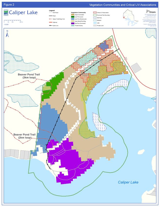
6.1.1.1 Representation Analysis
A complete representation analysis (Crins and Kor 2000) using landform-vegetation
(L/V) information was conducted for Caliper Lake Provincial Park. Despite the park’s
small size, Caliper Lake Provincial Park makes a significant contribution to the minimum
representation guidelines for the Kenora Ecodistrict. The park contains nine different
L/V associations, four of which are critical in meeting the representation targets for the
16Kenora Ecodistrict. Critical L/V associations include: open marsh/fen/bog, thicket
swamp, aspen dominated, and Jack pine mixedwoods all on fine lacustrine and
glaciolacustrine soil. Caliper Lake Provincial Park contributes the only representation of
Jack pine mixedwoods and a high component of thicket swamp on fine lacustrine and
glaciolacustrine soils in protected areas in the Kenora Ecodistrict.
6.1.1.2 Vegetation Communities
Caliper Lake Provincial Park is located within a transition zone where Great Lakes-St.
Lawrence forest and boreal forest both exist (Rowe 1972). In general, six major forest
communities represent the vegetation cover in Caliper Lake Provincial Park. They can
be generally described as: red pine - white pine uplands, pure Jack pine, Jack pine
mixed woods, ash-alder-willow wetlands, marsh wetlands, and aspen dominated mixed
woods (Goddard 1983; OMNR 2005).
Although mature red and white pine stands are representative of the region, the stands
in Caliper Lake are unique due to their large size, age and uniformity (Goddard 1983).
Upper canopy trees within the stands reach heights of 30 – 40 metres with an average
diameter at breast height measurement of fifty centimetres (Goddard 1983). Forest
Resource Inventory (FRI) data indicates the pine stand originated around 1840. Much
of this community is included in the development zone; however a substantial proportion
has been included in the nature reserve zones, where it will receive the maximum level
of protection. Over the years, the white pine trees have been affected by minor
infestations of white pine blister rust and lightning strikes. With aggressive fire
suppression action, the fire cycle has increased dramatically in recent years, which has
resulted in a shift in forest age class and species composition (e.g., higher presence of
fire sensitive, shade-tolerant species such as balsam fir, and reduced red and white
pine regeneration).
6.1.1.1 Fauna
Although a detailed inventory has not been completed for Caliper Lake Provincial Park,
the fauna is typical of the Great Lakes-St. Lawrence forest and also contains elements
of the boreal forest. Species common to the park are white-tailed deer, wolf, lynx and
various year-round and migratory birds (Goddard 1983). Bald eagle, a species
designated as special concern and American white pelican, a species designated as
threatened on the Species at Risk (SAR) in Ontario list are common in the area (OMNR
2013). Bald eagles and barred owls have been known to nest within the park
boundaries (Goddard 1983) and white pelicans nest in large colonies on nearby Lake of
the Woods (Harris and Foster 2004).
1718
6.1.2 Earth Sciences

Caliper Lake Provincial Park encompasses a moderately-broken terrain typical of the
Precambrian Shield of northwestern Ontario and lies within the Wabigoon Subprovince
of the Superior Province. Steeply sloping bedrock knolls and ridges outcrop along much
of the shoreline and form basins in which swamps and bogs marked by thick clay
deposits and organic build-up are common (Kor 1977). Several cliff faces of various
heights not exceeding about five metres occur within the park.

Surficial deposits, remnants of the last glacial event about 11,700 years ago, consist
predominantly of a very thin to patchy mantle of glacial sediment, namely medium-
grained, dark to medium-brown, silty, clayey sand till (Kor 1977). Boulders of local origin
are common, and various sized stones are strewn throughout the park. One erratic
boulder, consisting of a felsic volcanic rock, occupies a prominent position on the nature
trail (Kor 2009).

       6.1.3 Cultural Heritage Resources

Caliper Lake Provincial Park is situated in an area rich in cultural history.

The Lake of the Woods area provided productive hunting grounds, wild rice fields and
numerous transportation routes, which were the basis of survival for the Cree and
Assiniboine (and later the Ojibway) people (Beaudry and Lavender-Sexsmith 1983).
Relatively little is known about the cultural affiliations and distribution of Aboriginal
people prior to European contact (Beaudry and Lavender-Sexsmith 1983). A testimony
to the area’s rich Aboriginal history is the existence of several First Nation communities
located in the Lake of the Woods area (Figure 1).

The French began to explore the Rainy Lake-Lake of the Woods area during the 17th
century in search of profitable furs, and both the French and English had established fur
trade posts after 1700 (Beaudry and Lavender-Sexsmith 1983). The construction of
Highway 71, linking Kenora and Fort Frances, was a public works effort during the
Great Depression. Upon completion in 1936, tourism began to increase in the area.
Sioux Narrows – Nestor Falls continues to be a popular vacation destination.

No known cultural heritage or archaeological features exist within the park boundaries,
however there are two registered archaeological sites located in close proximity to the
park Lambert 1983). It is believed that “the lack of known historical values in the park
may reflect its isolation from the mainstream of local fur trade routes” (Beaudry and
Lavender-Sexmith 1983).

6.2 Recreation Objective
The park’s recreation objective is:

                                             19
To continue to provide high-quality day-use and overnight camping opportunities
in a manner which considers and attempts to minimize the associated impacts of
such activities on the park and surrounding ecosystem.
Caliper Lake Provincial Park provides numerous opportunities for a variety of
compatible high quality recreational activities. The park includes facilities for car
camping and day-use. The most popular activities include: resting/relaxing,
swimming/wading, canoeing, hiking, fishing, and viewing/photographing nature (Ontario
Parks 2000).
Although the park is officially closed in the winter, some activities do take place in the
park by local residents such as: cross country skiing (on un-groomed trails),
snowshoeing and walking.
6.3 Heritage Appreciation Objective
The park’s heritage appreciation objective is:
To provide park visitors with opportunities to learn about the natural heritage
features of Caliper Lake, such as glacial history, vegetation communities, including
the pine forest, and the conditions and species these values support. Cultural
heritage themes relevant to the park will be included, should resources be
discovered.
Natural heritage education for Caliper Lake Provincial Park is conducted through self-
use facilities, including; a self-guided nature trail and informal interpretive displays in the
park office.
7 BOUNDARY
The boundary of Caliper Lake includes all lands and lake bed regulated (147.35
hectares) under the PPCRA as Caliper Lake Provincial Park (Figure 3).
The park is bordered by Crown land in the west, with the exception of one small private
parcel of land on the Caliper Lake shoreline, and Caliper Lake in the east. Highway 71
abuts the northeast boundary. There is no private land within the park boundary;
however private lands are accessed from the park road. The park boundary extends
152.4 metres (500 feet) into Caliper Lake to include that portion of the lake bed.
Within the regulated park boundary, the protection of park values and features will be
achieved through appropriate zoning, the control of land use and activities, education,
and monitoring of ecological impacts.
The PPCRA governs activities within provincial parks and applies only to lands and
waters within regulated boundaries of parks and conservation reserves.
20Additions to the park will be considered if the property is needed to enhance the values
of the park. Potential acquisitions are subject to available resources and the willingness
of the owners to sell or lease their properties.
8 ADJACENT LAND USES
Several parcels of private land are located on Caliper Lake, one of which is directly
adjacent to the park. The park road is used to access private lands beyond the park
boundary.
Caliper Lake Provincial Park is surrounded by an active trapline area (FF5), an active
bear management area (BMA; FF-07B-097) and an active bait harvest area
(FF0156). The regulated park is excluded from these areas. Crown lands adjacent to the
park are within the Crossroute Forest Management Unit.
Part of the park hiking trail is located on Crown land outside of the park. For operational
reasons and to protect and enhance the recreational interests that this trail provides, this
area (approximately 33 hectares) may be added to the park through a future land use
planning process, subject to consultation.
An Ontario Federation of Snowmobile Clubs trail exists on Caliper Lake (Section 8.4.3).
9 PARK POLICIES
The following policies apply to the whole park.
9.1 Industrial and Commercial Uses
The following industrial activities are prohibited in Caliper Lake Provincial Park:
o commercial timber harvest;
o prospecting, staking of mining claims, developing mineral interests, working mines;
o extracting aggregate, topsoil or peat;
o generation of electricity;
o other industrial uses.
o
The following commercial activities are prohibited in Caliper Lake Provincial Park:
o trapping
o bait harvesting
o bear management area(s) (BMA).
2122
9.2 Adaptive Management
An adaptive management approach will be applied to resource management activities
within Caliper Lake Provincial Park. The main premise behind adaptive management is
that ecosystems are complex and dynamic. Our understanding of ecosystems and our
ability to predict how they will respond to our management actions and disturbances is
often limited. These knowledge gaps lead to uncertainty over how best to manage parks
to meet the obligation of maintaining ecological integrity.

Implementing an adaptive management approach allows researchers to design robust
experiments, with careful consideration, to evaluate management options. This in turn
provides park managers with directly relevant and scientifically defensible information to
help them make management decisions (Kingston and Mosley 2007).

9.3 Resource Management Policies
Planning and management decisions are intended to ensure the maintenance of
ecological integrity of protected areas. Consideration will also be given to social and
economic components. Ontario Parks will ensure that these decisions are made with
the best available information. Where this information is lacking, Ontario Parks may
conduct research, inventories and monitoring, as necessary, to provide this information.
Such efforts will be undertaken based on established methodologies and best practices
and will foster an adaptive management approach.

The site specific policies that follow will guide the management of park resources
consistent with the PPCRA, the Endangered Species Act, 2007 (ESA), and with the
requirements of the Environmental Assessment Act, 1990 (EAA). Resource
management projects and activities will be undertaken consistent with the Class EA-
PPCR, where applicable.

For greater certainty, nothing in this plan shall be construed so as to abrogate or derogate
from the protection provided for the existing aboriginal or treaty rights of the aboriginal
peoples of Canada as recognized and affirmed in section 35 of the Constitution Act, 1982
(2007, c. 6, s. 46).

     9.3.1    Land Management

Management of the Caliper Lake Provincial Park land base will be directed towards
maintaining the park’s natural landscape and protecting its ecological integrity.

A right-of-way for an electricity distribution line, under authority of a land use permit
(LUP), extends through the park to provide power to the park and the adjacent cottages
(Section 9.3.7).

Comfort station waste generated from campground use will be disposed of using
Ministry of the Environment-approved septic systems.

                                            23
No private recreation camps, boat caches or commercial tourism operations exist within
Caliper Lake Provincial Park. No new private, non-commercial dispositions or outright
sale of park land are permitted.
Commercial agreements (eg. LUP, leases, etc.) may be entered into or renewed.
9.3.2 Water Management
The health and integrity of ecological communities, existing within aquatic areas, will be
given priority when assessing feasibility and potential negative effects of any new
developments or activities.
Drinking and bathing beach water sampling and testing will be carried out in compliance
with:
• the Safe Drinking Water Act, 2002 and associated regulations; and the
• Ontario Beach Monitoring Protocol.
9.3.3 Alien and Invasive Species
Ontario’s Biodiversity Strategy defines alien species (also referred to as introduced,
non-native or exotic species) as “plants, animals and micro-organisms that have been
accidentally or deliberately introduced into areas beyond their normal range”. Alien
species will not be deliberately introduced into Caliper Lake Provincial Park (Ontario
Biodiversity Council 2011).
There are several common alien species (e.g., white sweet clover, three-toothed
cinquefoil, stinging nettle and oxeye daisy) established in the park, however none are
known to currently threaten natural or cultural values. Section 9.3.12, identifies the
monitoring efforts in place within the park.
Where possible, actions will be taken to eliminate or reduce the threat of invasive
species which may be affecting naturally occurring populations. Where alien invasive
species are already established and threaten natural or cultural values, a control
program may be undertaken if feasible and practical.
9.3.4 Insects and Diseases
Native insects and disease are a natural and integral part of the ecology of Caliper Lake
Provincial Park that will normally be allowed to fulfill their ecological role. In exceptional
circumstances, control measures will be considered if values of the park are threatened.
Insect and disease control measures for alien, and in some extreme cases native
species, will be considered if the values, including the ecological integrity, of the park
are threatened.
Forest insect and disease infestations may be monitored, assessed and treated in the
campground for aesthetic and safety reasons. In extreme cases, treatment may take
place to minimize effects of insects and disease on campground aesthetics.
24You can also read