NAMADGI NATIONAL PARK FERAL HORSE MANAGEMENT PLAN - SEPTEMBER 2020
←
→
Page content transcription
If your browser does not render page correctly, please read the page content below
NAMADGI NATIONAL
PARK FERAL HORSE
MANAGEMENT PLAN
SEPTEMBER 2020
ISBN: 978-1-921117-73-2

Cover image
Feral horses and stream bank damage on Chance Creek, Kosciuszko NP in 2015
(NSW Government)

Acknowledgement of Country
The ACT Government acknowledges Ngunnawal people as the Traditional
Custodians of the ACT, and honours the cultural legacy of their ancestors and the
ongoing responsibility they still carry in managing Country today. The region was
also a significant meeting place for neighbouring language and clan groups who
came for ceremonies, trade, seasonal resources, exchange of knowledge and to
maintain spiritual, social and environmental connectivity between traditional
caretakers. For thousands of years the Ngunnawal people have maintained a
tangible and intangible cultural, social, environmental, spiritual and economic
connection to these lands and waters. We pay our respects to elders past, present
and emerging, and their continued connection to Country.

© Australian Capital Territory, Canberra 2020.
This work is copyright. Apart from any use as permitted under the Copyright Act 1968,
no part may be reproduced by any process without written permission from:

Director-General, Environment, Planning and Sustainable Development Directorate,
ACT Government, GPO Box 158, Canberra ACT 2601.

Telephone: 02 6207 1923
Website: environment.act.gov.au

Produced by the
Environment, Planning and Sustainable Development Directorate

Accessibility
The ACT Government is committed to making its information, services, events
and venues as accessible as possible.

If you have difficulty reading a standard printed document and would like to
receive this publication in an alternative format, such as large print, please phone
Access Canberra on 13 22 81 or email the Environment, Planning and Sustainable
Development Directorate at EPSDDComms@act.gov.au

If English is not your first language and you require a translating and interpreting
service, please phone 13 14 50.

If you are deaf, or have a speech or hearing impairment, and need the teletypewriter
service, please phone 13 36 77 and ask for Access Canberra on 13 22 81.

For speak and listen users, please phone 1300 555 727
and ask for Canberra Connect on 13 22 81.

For more information on these services visit relayservice.com.au

    PRINTED ON RECYCLED PAPER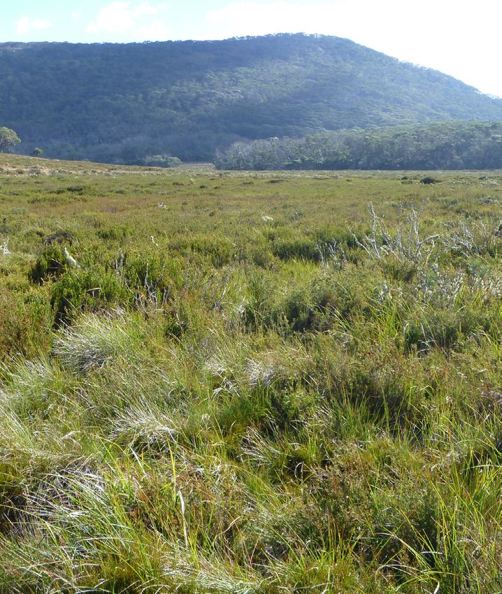
CONTENTS
1. INTRODUCTION.............................................................. 1    5. MONITORING AND ASSESSMENT OF FERAL HORSE
                                                                                      MANAGEMENT IN NAMADGI NATIONAL PARK .....................27

2. FERAL HORSES .............................................................. 3
                                                                                   REFERENCES..................................................................... 29
2.1 Social organisation, biology and ecology.................. 3

2.2 Environmental impacts ................................................. 3
                                                                                   APPENDIX 1. ..................................................................... 35

3. FERAL HORSES IN NAMADGI NATIONAL PARK
   AND THE SURROUNDING REGION.............................. 5
                                                                                   Box 1.
3.1 Historical distribution and control                                            Recovery following removal of feral horses in 1987 ...... 6
activities in Namadgi National Park.................................. 5
                                                                                   Box 2.
3.2 Feral horses in the region.............................................. 7     A visual comparison of an undisturbed bog and
                                                                                   a bog subject to disturbance by feral horses................. 13
3.3 The threat to Namadgi National Park....................... 11
                                                                                   Figure 1:
3.4 Natural and cultural values of
                                                                                   Distribution of feral horses in NSW (as of 2016).............. 9
Namadgi National Park...................................................... 14
                                                                                   Figure 2:
3.5 Methods for control of feral horses............................ 19
                                                                                   Modelled feral horse distribution over a ten year
                                                                                   period.................................................................................... 11
4. NAMADGI NATIONAL PARK HORSE
                                                                                   Figure 3:
   MANAGEMENT STRATEGY .......................................... 23
                                                                                   Habitat potentially suitable for feral horses in
4.1 Management goal......................................................... 23    Namadgi NP.......................................................................... 12

4.2 Management objectives.............................................. 23         Table 1. Flora and fauna species threatened in the ACT
                                                                                   and located in Namadgi.................................................... 17
4.3 Management Strategies .............................................. 23

4.4 Methods for control...................................................... 24

4.5 Relevant policy and legislation.................................. 25

4.6 Community and stakeholder consultation ............. 25

                                                                        NAMADGI NATIONAL PARK FERAL HORSE MANAGEMENT PLAN                                                    III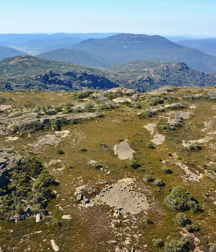
Namadgi National Park (M Jekabsons)
1. INTRODUCTION
Namadgi National Park (NP) covers 106,095 hectares, approximately 45%
of the Australian Capital Territory (ACT). The Park is located at the northern
end of the Australian Alps network of national parks, which is recognised for
its unique natural and cultural values and is included in Australia’s National
Heritage list. The National Heritage list is Australia’s list of natural, historic
and Indigenous places of outstanding heritage value to the nation.
Namadgi NP contains habitat for several threatened          Research across Australia (and abroad) demonstrates
species and threatened ecological communities.              that feral horses can have devastating impacts on
It also includes the headwaters of the Cotter River,        sensitive vegetation, native fauna species, and the
which provides an important source of water for the         hydrology of bogs and other water systems. To mitigate
Canberra and Queanbeyan communities, and contains           these risks, the ACT Government is committed to
many subalpine wetlands that have regional, national        maintaining a ‘zero-tolerance’ policy on the presence
and international significance.                             of feral horses in Namadgi NP.

The ACT Government in partnership with the                  Horses inhabit a wide range of ecosystems across
community is responsible for protecting the values          Australia, including high and low altitude grasslands,
of Namadgi NP. The Namadgi National Park Plan of            forests, deserts and ocean shores. In the broader ACT
Management (hereafter Namadgi PoM) outlines the             region, most feral horses occur in subalpine national
natural, cultural and social values of the Park, as well    parks of the Australian Alps. Horses first established
as threats to these values and associated management        wild populations in the ACT in the 1800s and their
objectives to maintain and enhance them. Importantly,       numbers have fluctuated since.
the Namadgi PoM includes the following objective to
                                                            The first plan to manage feral horses in Namadgi NP
protect water quality:
                                                            was prepared in 2004. A combination of management
→→ The ecological and hydrological condition of water       techniques (including barrier fencing, trapping and
   catchments is maintained and, where desirable            removal, and humane destruction, or ground-based
   and feasible, improved, to ensure a continuing high      shooting) were trialled under this Plan.
   quality and cost-effective water supply for the ACT
                                                            A revised version of this Plan was released in
Managing pest animals, including mitigating the             2007, which, consistent with the 2004 Plan, aimed
impacts of feral horses, is one essential way to achieve    to ‘prevent the re-establishment of feral horse
this. It is also central to achieving the Namadgi PoM’s     populations within Namadgi NP, specifically
objective to:                                               relating to the potential for these animals to cause
→→ Reduce and control pest animal numbers and,              undesirable impacts to sub-alpine wetlands’ (ACT
   where feasible, eradicate pest animals from the park     Government 2007). Since the release of the 2007
   through the implementation of control programs           plan, 24 horses have been trapped and humanely
   that are integrated with landscape and biodiversity      destroyed in Namadgi NP. There are no resident
   conservation and ecological restoration objectives       populations of feral horses in Namadgi NP today.
   (ACT Government 2010)

                                                    NAMADGI NATIONAL PARK FERAL HORSE MANAGEMENT PLAN                1
Namadgi National Park

            This Plan is a revision and update of the 2007
            Namadgi National Park Feral Horse Management
            Plan. It is informed by the successes of previous ACT
            horse management plans, feral horse management
            in the region, the ACT Vertebrate Pest Management
            Strategy (ACT Government 2012), and relevant
            national codes of practice (COP) and standard
            operating procedures (SOPs) for managing pests.

            This Plan outlines:

               »» feral horse biology and ecology
               »» the history of horses in Namadgi NP and their
                  current distribution and impacts in the region
               »» the outcomes of feral horse management
                  since the release of the 2007 Management
                  Plan
               »» the natural, cultural and water values of
                  Namadgi NP at risk from feral horses
               »» the future goals and objectives of managing
                  feral horse impacts in Namadgi NP
               »» legislation and policy relevant to managing
                  feral horses in Namadgi NP.

            While a formal review of this Plan is not required
            under ACT legislation, it is critical that the Plan
            remains relevant and up to date. This Plan will
            be updated to include new information that
            can inform control activities within the ACT (e.g.
            from research findings or experience in other
            jurisdictions) and if there are significant changes in
            the abundance and distribution of feral horses in
            the region. It is anticipated that a full review of the
            Plan will be undertaken within ten years.

       2 ENVIRONMENT.ACT.GOV.AU
2. FERAL HORSES
2.1 SOCIAL ORGANISATION, BIOLOGY AND ECOLOGY
Feral horses form two main societal groups: harems           The life expectancy of wild horses is less than domestic
and bachelor groups. Typically, harems are small             horses, which can live for more than 30 years. However,
breeding groups that contain a dominant stallion             due to an abundance of water and food (even in times
(or occasionally several) and three or more mares and        of drought), and lack of predators, feral horses in the
their foals. Breeding stallions can be replaced in a         region are likely to have longer life spans than most
group but mares form the stable, long-term centre            wild horses in Australia (NSW Government 2016a).
of harems (Van Dierendonck & Goodwin 2005).
                                                             Without human intervention, horse populations most
Harems generally occupy a well-defined, small
                                                             commonly increase by approximately 20% every year
geographic area, often surrounding a permanent water
                                                             (Garrott et al. 1991; Australian Government 2011).
source (Dobbie et al. 1993; Csurhes et al. 2016). Young
                                                             Depending on environmental conditions and available
and old stallions that have been overthrown from
                                                             resources, populations of feral horses can increase at
harems or have lost their group often congregate in less
                                                             rates above 30% in a single year (Grange et al. 2009;
stable, mobile bachelor groups that occupy larger areas
                                                             Scorolli & Cazorla 2010; Cairns 2019). Data from aerial
(Dobbie et al. 1993; Van Dierendonck & Goodwin 2005).
                                                             surveys undertaken across the Australian Alps estimate
Feral horses are estimated to have home ranges               that between 2014 and 2019 the feral horse population
between 9.76km2 and 32km2 (Csurhes et al. 2016;              increased annually by approximately 23% (Cairns 2019).
NSW Government 2016a), but this varies both within
                                                             The peak breeding season for horses is spring and
and between populations (Linklater 2000). The average
                                                             summer. Mares reach puberty between 12 and 24 months
size of harem and bachelor groups in the Australian
                                                             of age (Dobbie et al. 1993) but in many cases will not
Alps is between 5 and 6 individuals (Walter & Hone
                                                             produce young before the age of three years (Linklater
2003); recent survey results indicate the current
                                                             et al. 2004; Dawson & Hone 2012). Although capable of
maximum group size is 28 (Cairns 2019).
                                                             breeding successfully every year, mares commonly raise
Horse mortality is highest in the first year of life         one foal every two years (Dobbie et al. 1993).
and generally declines with age (Dobbie et al. 1993;
Linklater et al. 2004).

2.2 ENVIRONMENTAL IMPACTS
A meta-analysis undertaken by Eldridge et al. (2020)         Similarly to other non-native herbivores, horses can
identified the negative effects of feral horses on           cause significant environmental damage primarily via
ecosystem structure, function and composition across         herbivory and the degradation of habitats, including
the globe. In Australia, the impacts of feral horses were    trampling vegetation, contributing to soil erosion and
considered as early as the 1950s (see Costin 1954;           compaction, and impacting the function and integrity
Costin 1957) and research investigating their impacts        of water bodies (see section 3.2 and also: Rogers 1991;
was first undertaken in Central Australia in the 1980s       Taylor 1995; Beever & Brussard 2000; Campbell &
(see Berman & Jarman 1988) and in the Australian             Gibson 2001; Beever & Herrick 2006). Unsurprisingly,
highlands in the 1990s (see Dyring 1990). Since this         these impacts can have flow-on effects on native
time, considerable research has been undertaken to           wildlife (Beever & Brussard 2004; Zalba & Cozzani 2004;
better understand the impacts of feral horses in the         Ward-Fear et al. 2017).
Alps region (see Section 3.2).

                                                     NAMADGI NATIONAL PARK FERAL HORSE MANAGEMENT PLAN              3
Cotter Source Bog (M Jekabsons)

      4 ENVIRONMENT.ACT.GOV.AU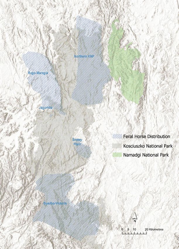
3. FERAL HORSES IN
    NAMADGI NATIONAL PARK
    AND THE SURROUNDING
    REGION
3.1 HISTORICAL DISTRIBUTION AND CONTROL ACTIVITIES
IN NAMADGI NATIONAL PARK
The population of feral horses within the ACT has            Trap yards were erected in early 2004 to capture
varied in response to both natural events and control        the animals and lead them to vehicle transport.
measures. It is likely that feral horses first established   The plan was unsuccessful as the horses were unable
in the area that is now Namadgi NP from animals              to be located and had likely returned to Kosciuszko to
escaping from Brindabella Station, Yaouk, Tidbinbilla        escape dry conditions. The same core group of horses,
property and the Cotter Hut area in the mid-1800s            which had grown to between 10 and 15 individuals,
(Moore 1999). As they were perceived to be competing         moved between Kosciuszko NP, and Mt Murray and
with cattle, by the 1860s feral horses were caught for       Jack’s Flat during 2005 and 2006.
sale or shot (Higgins 1993). Organised ‘brumby running’
                                                             During 2003 and 2004, a group of four horses also
(i.e. the chasing and capturing of wild horses from
                                                             moved between Orroral Valley, Cotter Gap and Corin
horseback) was undertaken as early as the 1920s
                                                             Dam. These animals were observed causing damage to
and remained popular in the area up until the early
                                                             the Rock Flats Wetland, which is listed as a Nationally
1960s (Higgins 1993). A number of historic trapping
                                                             Important Wetland (Australian Government 2019).
yards, seven of which are listed on the ACT Heritage
                                                             A ground shooting operation was undertaken in 2004
Register (ACT Heritage Council n.d.), illustrate the
                                                             to cull the horses. Despite the detailed planning and
early distribution of feral horses across Namadgi NP
                                                             experience of staff, only two of the four horses were
(Higgins 1993). This includes areas around Snowy Flats,
                                                             shot successfully; the other two horses escaped
Mt Ginini, and Smokers, Kangaroo and Creamy Flats.
                                                             uninjured. Another ground-based operation was
Despite brumby running, the population of feral              organised three months later and was successful in
horses was approximately 200 during the 1950s and            dispatching the remaining two horses.
1960s (Walter 2002). Most of those horses residing at
                                                             In 2004, barrier fencing was constructed near
high altitudes are believed to have been eliminated
                                                             Jack’s Flat, Murray’s Gap and Leura Gap to prevent the
during heavy snowfalls in 1964. The remaining horses
                                                             movement of horses from Kosciuszko NP into Namadgi
were eradicated by aerial and ground shooting in
                                                             NP. The effectiveness of the fences was limited as they
1987 (Walter 2002), in accordance with the Namadgi
                                                             required significant maintenance and, in some areas,
National Park PoM (ACT PCS 1986) (see Box 1).
                                                             horses were able to move around the barriers.
Namadgi NP remained free of feral horses until
2001-02 when bushwalkers reported horses and horse
sign at Jack’s Flat, on the ACT border. Management
staff confirmed the presence of these horses in 2003.

                                                     NAMADGI NATIONAL PARK FERAL HORSE MANAGEMENT PLAN             5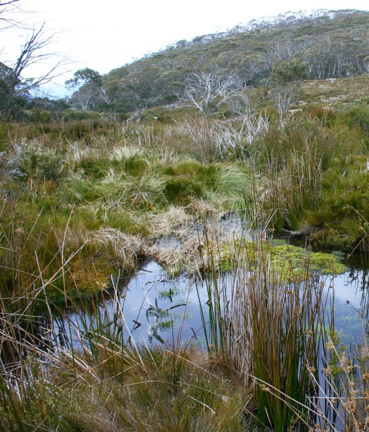
Box 1. Recovery following removal of feral horses in 1987
Feral horses were removed from Smoker’s Gap, Namadgi NP in 1987. The image taken in 1988 illustrates the
rapid recovery of the area seven months after their removal. There is an increase in sedges and less open
water, which is likely to have provided increased habitat for invertebrates and frogs. Today, over 30 years since
horses were removed, sedges remain abundant and the ground cover has a more diverse structure (including
large tussocks of Poa and Carex). The shrubs fringing the aquatic habitat have also become more abundant.
The improvements in vegetation structure are likely to provide increased habitat for a range of fauna species.
Small groups of horses, with home ranges likely to include northern Kosciuszko NP, were observed around
Bimberi Flat in 2006. Since the implementation of the 2007 Namadgi NP Feral Horse Management Plan,
24 horses have been trapped and humanely destroyed in Namadgi NP. Today, the only known presence
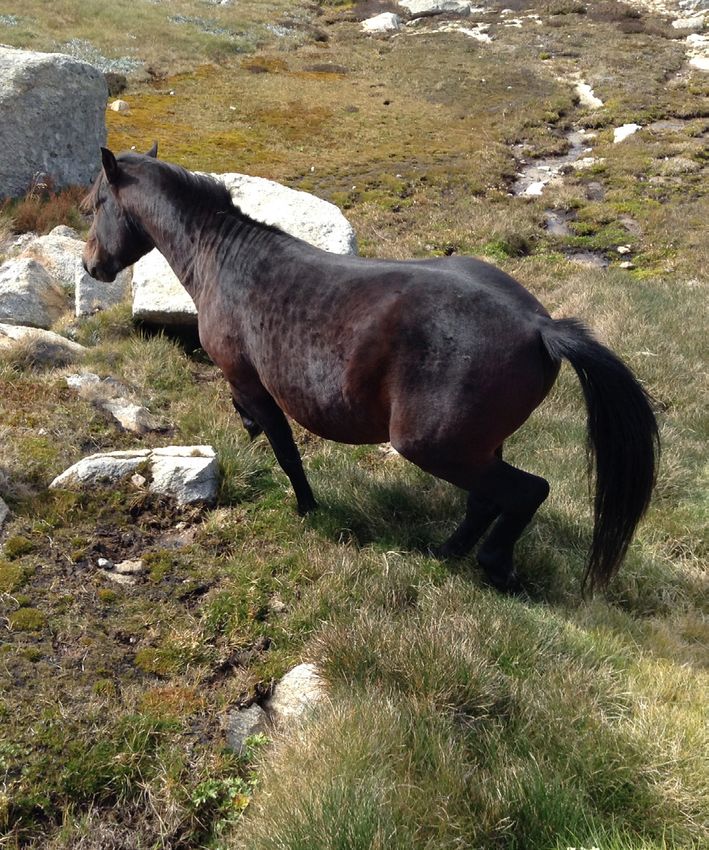
of feral horses in the Park is one lone stallion that frequents the border region between Kosciuszko NP
and Namadgi NP near Mt Bimberi. There is a group of semi-wild domestic horses in the Clear Range area,
which have the potential to form a feral population within Namadgi NP. No resident feral horses have
been recorded in Namadgi NP since 2011.
(Sept) (April)
1987 1988
(June)
2020
6 ENVIRONMENT.ACT.GOV.AU3.2 FERAL HORSES IN THE REGION
Distribution of feral horses
Feral horses have been present in the Australian Alps Significant areas of the Australian Alps, particularly
since the early 1830s and today they occur in considerable Kosciuszko NP, were burnt during wildfires in 2020.
numbers across the region, including: Kosciuszko NP Aerial surveys have not been undertaken to assess the
(NSW), Bago State Forest (NSW), Maragle State Forest impacts on feral horses. However, it is likely that few
(NSW), Alpine NP and adjacent state forest (Victoria), animals would have been lost through direct mortality
as well as some adjoining private property in both NSW and any potential reduction in the population in the
and Victoria. The primary distribution of feral horses in following months (due possibly to a decline in available
NSW is illustrated in Figure 1 (see also Cairns 2019). resources) is likely to be followed by significant annual
growth rates.
Since 2001, five aerial surveys have been conducted
to estimate the population of feral horses across the
Australian Alps. In 2014, the population of feral horses Impacts of feral horses
was approximately 9,187; by 2019, the population
expanded to 25,318 (Cairns 2019). Driscoll et al. (2019) argue that the impact of feral
horses is currently the most significant threat operating
The population of feral horses within the northern at a landscape level across the Australian Alps.
area of Kosciuszko NP, which poses the biggest threat Despite some control measures (see Section 3.5),
to Namadgi NP (see Section 3.3), has grown at an feral horses continue to exert significant pressure
annual rate of 37% since 2014 (Cairns 2019). In 2014, on waterways, vegetation and fauna in the region,
the population was estimated at 3,255; by 2019 the including threatened communities and species, and
population grew to 15,687 (Cairns 2019). In 2019, the cultural heritage values.
density of horses in this area was approximately
11.5 horses per km2, which is substantially higher than
areas surveyed in Bago and Maragle State Forests, and Natural values
the Byadbo and northern Victoria region (1.3 and 2.63
horses per km2 respectively) (Cairns 2019). It is unclear The Australian Alps region is a significant source of
whether available resources and/or unpredictable water, contributing approximately 29% to the average
climate and natural events, such as fire, will limit surface water of the Murray-Darling Rivers (Driscoll et
further population growth. It is possible that the al. 2019). Damage to water courses by feral horses has
number of feral horses in the area will continue to implications for the integrity and biodiversity values
grow and their range expand. of those systems. Specifically, the pressure that feral
horses place on alpine moss bogs and riparian zones
The Australian Alps National Parks were impacted by in the region is degrading water quality and increasing
large-scale wildfires in 2002-03 and 2020. The 2002-03 variability in rates of water flow from mountain
wildfires burned large parts of the Australian Alps, catchments (see Box 2 and Pittock & Finlayson 2018).
including over 70% of the distribution of the feral Several studies have illustrated significant impacts
horse population. This included 100% of their range from feral horses on soils (e.g. erosion), vegetation
in Victoria but very little of their range in northern (e.g. trampling and loss of cover), temperature and
Kosciuszko (Walter 2003). While the number of feral condition (e.g. sedimentation and nutrient level)
horses across the Alps declined immediately following of water associated with streams and Sphagnum
the fire (Walter 2003), the population responded bogs (including those listed as threatened under the
quickly afterwards, increasing at an annual rate of over Environment Protection and Biodiversity Conservation
21% in the five years following the fire (Dawson 2009). Act 1999 [the EPBC Act]) (Dyring 1990; Porfirio et al.
2017; Paul 2018; Tolsma et al. 2018; Cherubin et al.
2019; Foster & Scheele 2019; Robertson et al. 2019;
Scanes & Dickson 2020).
NAMADGI NATIONAL PARK FERAL HORSE MANAGEMENT PLAN 7Broad-toothed Rat (K. Green)
Feral horses travel on defined tracks, which often Recent research also illustrates the damage caused
exhibit signs of trampling and selective grazing by horses around small, seasonally flooded pools
(Dyring 1990). Soils along these routes and other areas reduces habitat quality for breeding Corroboree Frogs
trampled by horses can have altered hydrology and (Pseudophryne pengilleyi) (Foster & Scheele 2019).
may be structurally damaged, leading to erosion and
soil loss, or compacted (Dyring 1990; Ward-Jones et Cultural heritage values
al. 2019). Trampling and grazing may also contribute
There are many sites throughout the region that
to changes in subalpine and alpine native vegetation.
demonstrate the historical and ongoing connection
Various research projects have illustrated that the
of Ngunnawal people to the landscape. This includes
cover, structure, condition and richness of subalpine
both archaeological sites and places associated with
and alpine vegetation across the region’s grasslands,
traditional stories and teachings. Horses can cause direct
heath, woodlands and wetlands (including those listed
or indirect damage to sites through grazing and trampling
as threatened under the EPBC Act) can be negatively
vegetation, and damaging soils. Damage to Ngunnawal
impacted by the presence of feral horses (Dyring 1990;
sites in the region has been documented where feral
Bie and Vesk 2014; Porfirio et al. 2017; Tolsma et al.
horses are known to occur in moderate to high
2018; Cherubin et al. 2019; Ward-Jones et al. 2019).
densities (NSW Government 2016a; Parks Victoria 2018).
Impacts to waterbodies, soils and vegetation can result
in changes to fauna assemblages. For example, the
occurrence of horses in the Australian Alps is negatively Historical heritage values
associated with the presence and abundance of a
The Australian Alps have a strong association
range of invertebrates (Ward-Jones et al. 2019;
with Australia’s pioneering history. Mountain
Scanes and Dickson 2020). Cherubin et al. (2019)
huts, homesteads and stockyards are valued as
show that changes in vegetation of Sphagnum bogs
demonstrations of the cultural history of the area
associated with feral horses in Victoria impacts the
(Commonwealth of Australia 2008). By seeking shelter,
presence and abundance of the Alpine Water Skink
shade or mineral salts, feral horses have caused
(Eulamprus kosciuskoi) and the Broad-toothed Rat
physical damage to some of these assets, including
(Mastacomys fuscus). Similarly, Schulz et al. (2019)
several huts in Kosciuszko NP (NSW Government
demonstrate the need to protect drainage lines to
2016a). Other structures show signs of rubbing
prevent long-term declines, and potential localised
and chewing for salt (NSW Government 2016a).
extinctions, of the Broad-toothed Rat in Kosciuszko NP.
8 ENVIRONMENT.ACT.GOV.AUFigure 1: Distribution of feral horses in NSW (as of 2016) (NSW Government data 2016)
NAMADGI NATIONAL PARK FERAL HORSE MANAGEMENT PLAN 9Feral horse control plans and policies
Today, feral horses are found primarily in the northern and southern regions of the Australian Alps, including areas in both
NSW and Victoria. Control of feral horses in this region is currently undertaken in accordance with several plans, including:
STATE PLAN
NSW Kosciuszko National Park: Horse Management Plan - December 2008 (NSW Government 2007)
Victoria Protection of The Alpine National Park Feral Horse Strategic Action Plan 2018-2021 (Parks Victoria 2018)
ACT Namadgi National Park Feral Horse Management Plan 2007 (ACT Government 2007), to be replaced by
Namadgi National Park Feral Horse Management Plan 2020 (this plan) once finalised
A description of current policies guiding feral horse control across NSW and Victoria is outlined below. It is important
to note that strategies and issues relating to feral horse control are somewhat fluid in both jurisdictions.
New South Wales
Key objectives of the Kosciuszko National Park: While the NSW Government considers the full
Horse Management Plan - December 2008 are to implications of the Act, the 2016 Draft Wild Horse
exclude horses from several areas, including areas Management Plan - Kosciuszko National Park
adjoining other national parks and reserves, and (NSW Government 2016a) has not been finalised.
reduce numbers in other areas to reduce the risks The uncertainty of this policy is preventing effective,
they pose. Passive trapping, followed by removal, large-scale control of feral horses and their impacts
is the primary control method proposed; aerial in Kosciuszko NP.
shooting is not permitted under the Plan. A review of
the Kosciuszko National Park: Horse Management Plan
2008, undertaken in 2016, concluded that the 2008 Plan Victoria
failed to achieve the key objectives noted above, and
Significant numbers of feral horses exist across Victoria,
that trapping and removal was costly, time consuming
including large populations in the Alpine NP, which
and did not effectively reduce the wild horse
is a component of the Australian Alps National Parks
population (NSW Government 2016b). A revision of
network. The most recent surveys estimate the horse
the 2008 Plan, entitled: Draft Wild Horse Management
population in the southern Alps, which includes areas
Plan - Kosciuszko National Park, was drafted in 2016.
in both NSW and Victoria, to be 8,518 (Cairns 2019). The
Amongst other revisions, the revised Plan significantly
largest population of horses in Victoria is in the Eastern
expands proposed control methods (including the use
Alps, bordering Kosciuszko NP. There are also smaller
of trapping and culling on site) and aims to reduce
populations on the Bogong High Plains and in Barmah.
the density of the population of feral horses bordering
Namadgi NP (NSW Government 2016a). This plan is yet The Protection of the Alpine National Park - Feral
to be endorsed by the NSW Government. Horse Strategic Action Plan 2018-2021 is the first
plan for managing feral horse populations in Victoria’s
The NSW Government recently passed the Kosciuszko
Alpine NP. The Plan aims to remove 1,200 feral horses
Wild Horse Heritage Act 2018, which recognises and
from the Eastern Alps in the first three years. Trapping
aims to protect the heritage value of sustainable wild
and rehoming horses is a priority of the Plan (Parks
horse populations within parts of Kosciuszko NP.
Victoria 2018).
The Act requires the development of a Wild Horse
Heritage Management Plan for Kosciuszko NP.
Community and Scientific Advisory panels were
appointed in September 2019 to play a key role in the
development of this Plan.
10 ENVIRONMENT.ACT.GOV.AU3.3 THE THREAT TO NAMADGI NATIONAL PARK
There is significant opportunity for feral horses to While escaped and released domestic horses have the
expand into many areas of the Australian Alps not potential to establish feral populations in the Park, horses
currently occupied. Modelling undertaken by Beeton are most likely to enter Namadgi NP from populations
and Johnson (2019) predicts that, without population of feral horses in the northern plains of Kosciuszko NP.
control in the ACT and under current control regimes in Historically, horses have entered from this area through
Kosciuszko NP (and Victoria), feral horses would likely Bimberi Nature Reserve. In most cases, rough terrain
move into substantial areas of Namadgi NP. Figure 2 and thick vegetation has limited horse movements to
illustrates the modelled distribution of feral horses Murray and Leura Gaps and Jack’s Flat. However, fire may
within ten years if no control activities are undertaken remove vegetation and open up the landscape in such a
across the Australian Alps region. Figure 3 identifies way as to facilitate the movement of feral horses.
areas of habitat that are likely to be suitable for horses
The impact of extensive wildfires in 2020 may influence
across Namadgi NP. Subalpine bogs and wetlands
horse distribution patterns in northern Kosciuszko.
(i.e. aquatic herbfield/wet heathland), and grassland
However, preliminary observations undertaken by the
and heath communities are mapped as ‘preferred
ACT Government indicate key areas between Namadgi
habitat.’ Areas of ‘other potential habitat’ include
NP and north Kosciuszko remain unburnt. Thus, it is
communities mapped as woodland and riverine forest.
unlikely these wildfires have resulted in any considerable
Namadgi NP borders rural properties in the ACT and changes to the landscape that would further facilitate
NSW and there is potential for domestic horses to stray the movement of horses into Namadgi NP (O. Orgill
from properties into the Park. There is also a small risk 2020, pers. comm.). Nevertheless, recent control
that horses may be deliberately released into the Park if measures have been insufficient to deal with feral horse
owners are unable to adequately care for their animal/s. populations in NSW and, with current policy uncertainty,
While horse owners have a responsibility to contain the threat of horses migrating into Namadgi NP is
their animals, domestic horses have, in the past, entered extreme and ongoing (Beeton & Johnson 2019).
Namadgi NP from freehold properties in the Clear Range Results of surveys in 2019 indicate the density of horses
area. Cooperating with NSW agencies and neighbouring in Northern Kosciuszko is high and the number of
land holders is critical to mitigating this risk. animals has increased significantly in the last five years.
The ecological, cultural and water values of Namadgi NP
at risk by feral horses are outlined below.
Figure 2: Modelled feral horse distribution over a ten year period with no regional feral horse control and (left) low
annual population growth rate and dispersal speed (6% and approx. 0.5km/year respectively), and (right) high annual
growth rate and dispersal speed (17% and approx. 2km year respectively) (Beeton & Johnson 2019)
NAMADGI NATIONAL PARK FERAL HORSE MANAGEMENT PLAN 11Figure 3: Habitat potentially suitable for feral horses in Namadgi NP Preferred = bogs and fens, heath and grassland. Other Potential = woodland and riverine forest. 12 ENVIRONMENT.ACT.GOV.AU
Box 2. A visual comparison of an undisturbed bog and a bog subject to
disturbance by feral horses
The images below were taken in 2014. The image of Ginini Bog wetland in the ACT (a) illustrates Sphagnum bog
hummocks and dense and diverse heath (and other) vegetation, which provides habitat for a range of birds,
amphibians, reptiles and mammals, and protects soil from erosion. The water appears in good condition.

 (a)

Conversely, the water in the bog along Ingeegoodbee River in NSW that is impacted by feral horses (b), has
increased turbidity, the surrounding vegetation has been simplified (i.e. no heathland or Sphagnum) and the
banks are eroded. This system provides little habitat for fauna and leaves water open to evaporation.

 (b)                                                                                          G. Worboys

                                             NAMADGI NATIONAL PARK FERAL HORSE MANAGEMENT PLAN                 13
3.4 NATURAL AND CULTURAL VALUES OF
NAMADGI NATIONAL PARK
The natural landscape
The Australian Alps national parks network is The Directory of Important Wetlands in Australia lists
characterised by several landscape types including 11 nationally important wetlands in Namadgi NP:
alpine peaks, treeless high plains and frost hollows, →→ Cotter Flats
alpine and subalpine wetlands, significant river →→ Ginini and Cheyenne Flat complex
systems, tall wet forests, and Snow Gum and
→→ Rock Flats
Rainshadow Woodlands (Mackey et al. 2016).
Namadgi NP forms an important part of this network →→ Rotten Swamp
and exhibits a range of these landscape types. →→ Scabby Range Lake
→→ Snowy Flats
→→ Upper Cotter River
Alpine peaks
→→ Upper Naas Creek
There are no extensive areas of treeless alpine peaks
→→ Bendora Reservoir
and ridges in Namadgi NP. However, there are several
significant peaks, including Mounts Kelly, Murray, →→ Nursery Swamp
Ginini, Gingera, Scabby, Gudgenby and Namadgi, and →→ Cotter Source Bog.
Bimberi Peak. Subalpine valleys and frost hollows,
Bogs and wetlands in Namadgi NP play an important
where cold air drains and conditions are too cold
role in filtering and storing water and thus protecting
for tree growth, are associated with the undulating
water quality within the local catchment. They also
topography of Namadgi NP. Montane and subalpine
provide important habitat for the Critically Endangered
grasslands, including areas listed as part of the
Northern Corroboree Frog and the Vulnerable Broad-
Endangered Natural Temperate Grassland Ecological
toothed Rat and may support the Alpine Tree Frog
Community, are common in these valleys. Long Flat,
(Litoria verreauxii alpina). During the 2003 wildfires,
Grassy Creek, Orroral Valley, Sam’s Creek, Nursery
all 11 Nationally Important Wetlands were burnt; the
Creek, Rendezvous Creek, Bogong Creek, and Emu
extent of each wetland burnt ranged from 70-100%
Flats contain extensive areas of Natural Temperate
(Carey et al. 2003). Bogs, fens and other wetlands were
Grassland (ACT Government 2017a).
also significantly impacted during the 2020 Orroral
Valley wildfire, which burnt almost 80% of Namadgi NP
(ACT/NSW RRAT 2020). The majority of the 11 nationally
Wetlands
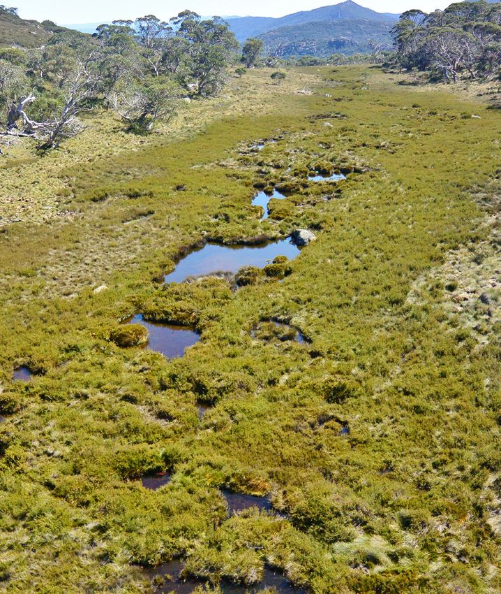
recognised wetlands were burnt and most sites were
Namadgi NP contains several alpine and subalpine burnt in their entirety (i.e. between 90-100% of the
wetlands (i.e. bogs and peatlands in high altitude extent of each wetland). The Ginini Wetland Complex
wetlands and waterways). Many of these areas have was not burnt.
local, national and/or international significance
While some wetlands recovered relatively quickly
and several are listed as Endangered and Critically
following the 2003 fires, it is likely to be a long time
Endangered under ACT and national legislation
before the cover of some species is restored (McDougall
respectively (see below). The Ginini Flats Wetland
2007). The process of recovery in some areas was
Complex is one of the largest, deepest and least
impeded by the impacts of the 2020 Orroral Valley
disturbed subalpine Sphagnum bogs in mainland
wildfire. Many of these systems are likely to remain
south-eastern Australia and is listed on the Ramsar List
sensitive to any additional threatening process, such as
of Wetlands of International Importance (Australian
feral horse impact, for a long time.
Government 2019).
14 ENVIRONMENT.ACT.GOV.AUNamadgi National Park (M Jekabsons)
Rivers
The Cotter, Paddys, Orroral, Naas and Gudgenby
Rivers are all located, at least in part, in Namadgi
NP (ACT Government 2018a). As well as playing
a key role in providing clean water to Canberra
and Queanbeyan communities, river and stream
systems have high biodiversity value, including
providing habitat for threatened aquatic species
(see below). Montane grasslands are commonly
associated with these systems in Namadgi NP;
common wooded vegetation includes Black
Sallee (Eucalyptus stellulata) and Ribbon Gum
(Eucalyptus viminalis).
Vegetation
According to the classification system developed
by Armstrong et al. (2013), there are 42 different
vegetation communities identified in Namadgi
NP. This includes communities broadly classified
as forest, woodland, grassland, heaths, and
bogs and fens. Dry and wet sclerophyll forests
cover over 87,000 hectares and are the most
widespread vegetation types in Namadgi NP.
Wet forests in Namadgi NP are dominated by
Alpine Ash (Eucalyptus delegatensis), Ribbon Gum
and Robertson’s Peppermint (E. radiata subsp.
robertsonii).
Subalpine and grassy woodland communities are
also common and cover over 55,000 hectares of
the Park. Woodlands and forests dominated by
Snow Gum (Eucalyptus pauciflora) cover extensive
areas (over 48,000 hectares) at the highest
elevations (ACT Government 2019c). Montane
grasslands most commonly occur on the broad
flats and lower slopes associated with creeks
and rivers, typically in areas with severe frosts
(ACT Government 2017a). Subalpine grasslands
commonly occur between Sphagnum moss bogs
and surrounding woodland (ACT Government
2017a). Together, montane and subalpine
grasslands (and other native grasslands) cover
approximately 26,000 hectares in Namadgi NP.
NAMADGI NATIONAL PARK FERAL HORSE MANAGEMENT PLAN 15Threatened species and ecological communities
Ecological communities
Three vegetation communities occurring within Namadgi These patches, which cover just over 200 hectares, are
NP are threatened under the ACT Nature Conservation Act a component of the White Box–Yellow Box–Blakely’s
2014: Red Gum Grassy Woodland and Derived Native
Grassland community, which is listed as Critically
→→ Critically Endangered Natural Temperate Grassland
Endangered under the EPBC Act.
(NTG)
→→ Critically Endangered Yellow Box – Blakely’s Red Endangered High Country Bogs and Fens occur in
Gum Grassy Woodland (YB-BRG Woodland) small isolated patches throughout the Australian Alps.
→→ Endangered High Country Bogs and Associated Patches of this community, many of which are
Fens. consistent with the EPBC listed Sphagnum Bogs and
Associated Fens, occur in Namadgi NP. These patches
Natural Temperate Grassland is one of the most represent the northern extent of the distribution of this
threatened ecosystems in Australia. The most extensive community and have ecological significance as they
areas of NTG in the ACT are located in valleys within provide habitat for rare and threatened species.
Namadgi NP (ACT Government 2017a). These include They also play an important role in maintaining the
Long Flat, Grassy Creek, Orroral Valley, Sam’s Creek, water supply for the ACT (ACT Government 2019e).
Nursery Creek, Rendezvous Creek, Bogong Creek, and The Ginini Flats Wetland Complex is the largest intact
Emu Flats (ACT Government 2017a). This community bog and fen community in the Australian Alps and,
forms part of the Natural Temperate Grassland of the as outlined above, has international significance (ACT
South Eastern Highlands community listed as Critically Government 2019e). Fire is identified as a key threat to
Endangered under the EPBC Act. this community because regeneration of associated
vegetation is primarily reliant on unburnt fragments.
Very small remnants of Critically Endangered YB-BRG
The vulnerability of the community to a range of other
Woodland occur in lower elevations in the eastern
threats, including large animals, also increases after fire
edges of Namadgi NP.
(Australian Government 2009). Although Ginini Flats
remained unburnt in 2020, large areas of bogs and fens
in Namadgi have burned twice in 17 years.
Northern Corrobboree Frog (M. Evans)
16 ENVIRONMENT.ACT.GOV.AUThreatened species
Six flora species and 17 species of fauna listed as threatened in the ACT are located within Namadgi NP (see Table 1).
Table 1. Flora and fauna species threatened in the ACT and located in Namadgi
NT= Near Threatened, V = Vulnerable, E = Endangered, CE = Critically Endangered
COMMONWEALTH ACT NATURE
FLORA EPBC ACT 1999 CONSERVATION NSW /
COMMON NAME SCIENTIFIC NAME (MNES) ACT 2014 VICTORIA*
Austral Toadflax Thesium australe V V V (NSW, Vic)
Baeuerlen’s Gentian Gentiana baeuerlenii E E E (NSW)
Brindabella midge Corunastylis ectopa CE CE -
orchid
Hoary Sunray Leucochrysum albicans var. E E (Vic)
tricolor
Kiandra Greenhood Pterostylis oreophila CE CE CE (NSW), E (Vic)
Orchidaceae** All species Various Protected native -
species
Pale Pomaderris Pomaderris pallida V V V (NSW)
COMMONWEALTH ACT NATURE
EPBC ACT 1999 CONSERVATION
FAUNA COMMON NAME SCIENTIFIC NAME (MNES) ACT 2014 NSW / VICTORIA*
Broad-toothed Rat Mastacomys fuscus mordicus V V V (NSW), E (Vic)
Brown Treecreeper Climacteris picumnus V
Brush-tailed Rock- Petrogale penicillata V E E (NSW), CE (Vic)
wallaby (locally extinct)
Greater Glider Petauroides volans V V V (Vic)
Hooded Robin Melanodryas cucullata V V (NSW), NT (Vic)
Little Eagle Hieraaetus morphnoides V V (NSW)
Macquarie Perch Macquaria australasica E E E (Vic)
Murray River Crayfish Euastacus armatus V NT (Vic)
Northern Corroboree Pseudophryne pengilleyi CE CE CE (NSW)
Frog
Scarlet Robin Petroica boodang V V (NSW)
Smoky Mouse Pseudomys fumeus E E CE (NSW), E (Vic)
Spotted-tailed Quoll Dasyurus maculatus E V V (NSW), E (Vic)
Trout Cod Maccullochella macquariensis E E CE (Vic)
Two-Spined Blackfish Gadopsis bispinosus V -
Varied Sittella Daphoenositta chrysoptera V V (NSW)
Verreaux’s Alpine Tree Frog Litoria verreauxii alpina V V E (NSW), CE (Vic)
White-winged Triller Lalage sueurii V -
* As listed under the NSW Biodiversity Conservation Act and the Victoria Threatened Species Advisory List and / or under the Victorian Flora and Fauna
Guarantee Act 1988.
** All species of orchids are listed as Protected Native Species under the ACT Nature Conservation Act. Several species are listed as threatened under
the EPBC Act.
NAMADGI NATIONAL PARK FERAL HORSE MANAGEMENT PLAN 17Corin Dam (Conservation Research photo library)
Water catchment values Cultural heritage values
To ensure that future generations can benefit from Namadgi NP has both Ngunnawal and European cultural
a safe and clean water supply, the protection of heritage values. Ngunnawal people are recognised as the
water resources is one of the highest priorities for Traditional Custodians of the Namadgi area and have held
management of Namadgi NP (ACT Government connections to the Country for thousands of years.
2010). For Ngunnawal people, maintaining connections with this
land and upholding traditional responsibilities to care for
Namadgi NP includes the primary water supply
the Country is vitally important. This includes maintaining
catchment for Canberra and protects 51% of
cultural sites and their associated stories that link places
all aquatic and riparian areas in the ACT (ACT
to people. There are many places and objects within
Government 2018a). The rivers that run through
Namadgi NP that are listed on the ACT Heritage Register.
Namadgi NP, including the Cotter, Paddys, Gudgenby
These sites are some of the most significant in the ACT
and Naas rivers, are important sources of water that
and include art sites, sacred landscape features, grinding
drain into the Murrumbidgee River system.
grooves and stone arrangements.
The western and southern boundaries of the Park
(and the ACT) are defined by the catchments of the Namadgi NP is included on the National Heritage List as
Cotter and Gudgenby river systems. The Park protects part of the Australian Alps National Parks and Reserves.
all of the upper and middle sections of the Cotter This listing recognises the area’s unique natural
Catchment and 65% of the lower Cotter Catchment environment, which includes a range of landforms, and
(ACT Government 2010). The Cotter Catchment longstanding human interaction, including the pioneering
supplies water storage reservoirs at Corin, history and scientific endeavours. The listing also
Bendora and Cotter. acknowledges the national heritage significance of past
large-scale annual gatherings of Ngunnawal and other
The Bimberi Wilderness Area, declared in 1989,
Aboriginal people associated with feasting on Bogong
includes most of the upper Cotter Catchment and
Moths (Agrotis infusa), which aestivate in large number in
comprises 27% of Namadgi NP. This area connects to
the Alps during summer (Commonwealth of Australia 2008).
wilderness areas in NSW and is managed primarily to
protect its value to the water supply, as a wilderness Namadgi has significant European cultural heritage values
area and as an opportunity for visitors to enjoy that date back to early colonisation and the establishment
solitude. Importantly, a key management objective of pastoralism and agriculture in the area. There are a
for wilderness areas (as outlined in the Planning and number of sites on the ACT Heritage Register that attest to
Development Act 2007) is to conserve the natural this rich history, including homesteads and huts, brumby
environment in a manner that ensures disturbance yards, and ploughlands. Orroral Valley and Honeysuckle
to that environment is minimal. Tracking Stations were key in Australia’s participation
in the United States’ Space Program. These sites, now
decommissioned, are recognised on the Australian Alps
National Heritage listing for their contribution to scientific
research (Commonwealth of Australia 2008).
Other historic land uses such as recreational skiing,
forestry and arboriculture, and water harvest are
outlined in the Namadgi PoM (ACT Government 2010).
18 ENVIRONMENT.ACT.GOV.AU3.5 METHODS FOR CONTROL OF FERAL HORSES
A wide range of methods for the control of feral horses have been assessed and implemented across the region and
elsewhere. The most suitable method in any circumstance depends on a range of factors, including number of horses,
mob size and age structure, accessibility, terrain, impacts and season. Key considerations are the humane treatment of
horses, the safety of people involved in operations, efficiency and available resources (including existing infrastructure),
and the socio-political setting. In many cases, a combination of control methods and techniques is most appropriate for
the control of feral horses. The key control methods that may be employed across the Australian Alps are outlined below.
Passive trapping and removal
The primary method to control feral horses in the The Australian Animal Welfare Standards and Guidelines
region has been to trap them in yards and transport – Land Transport of Livestock provides guidance to
them out of the area. Trapped horses may be rehomed minimise risks to the welfare of livestock, including
or sent to an abattoir or knackery. Passive trapping horses, during transportation (AHA 2012). The Code of
involves establishing yards and using lures (such as Practice for the Capture and Transport of Feral Horses
salt, molasses and/or lucerne) to encourage feral was developed as part of a report on the management
horses to enter the yards. Once inside, horses may be of feral horses in national parks in New South Wales
trapped individually or in groups of up to ten or more (English 2001). This report noted that even with the best
at a time. In 2019, 99 horses were trapped and removed system in place, the capture and subsequent transport
from the Blue Waterholes campground in Kosciuszko of feral horses is extremely stressful for animals (English
NP. The operation aimed to reduce interactions with 2001). Consultation undertaken by Straight Talk (2015)
the public and support safety objectives of the park. on management of feral horses in NSW, demonstrated
Trapping is time consuming and expensive but when the community has considerable concern about the
undertaken in easily accessible areas, it can be an stress endured by horses during transportation.
effective way to remove feral horses. As outlined in
The 2016 review of the Kosciuszko National Park:
Sharp (2011d), passive trapping is a preferred method
Horse Management Plan (NSW Government 2016b)
when managing horses at low densities.
found that trapping and live removal, as undertaken
While passive trapping is likely to have a mild to in Kosciuszko NP, has been expensive and has not
moderate impact on the overall welfare of horses effectively reduced the wild horse population or the
(Sharp & Saunders 2011; OEH 2014), loading and extent of associated impacts.
transporting horses over long journeys, when horses
Trapping and transporting will not be used for the
are not provided food or water for 4-24 hours, has a
control of feral horses in Namadgi NP but may be used
severe impact on their overall welfare (OEH 2014).
to remove ‘stray’ domestic horses from the park.
Horses grazing in a montane fen, Kosciuszko National Park. (NSW Government)
NAMADGI NATIONAL PARK FERAL HORSE MANAGEMENT PLAN 19Tussock grassland
Passive trapping and humane
destruction on site
Horses that are trapped using the methods
outlined above can be humanely destroyed
on site. This method has not been employed
commonly across the region, although it has taken
place in Namadgi NP (ACT Government 2007)
and is proposed in NSW Government (2016a) and
Parks Victoria (2018) in specific circumstances.
Importantly, this method prevents horses
enduring the stress of transportation and is not
limited by rehoming opportunities or other off-site
disposal means.
Ground shooting
Skilled shooters can be employed to find and
dispatch feral horses in a humane way. Ground
shooting can be an effective tool for mitigating
the impacts of feral horses but is best employed
in accessible, flat areas where there are low
numbers of individuals (Sharp 2011a). Importantly,
in wooded or rough terrain, it can be difficult
to follow individuals and ensure that wounded
animals are destroyed quickly (Sharp 2011a).
Ground shooting is not considered practical if
large-scale control is required (Sharp 2011a).
This method has not been employed broadly
across the Alps region. However, the Victorian
Government has plans to introduce ground
shooting of free ranging horses as a control
measure in areas where conservation is a high
priority. Ground shooting is also proposed as a
potential method in Draft Wild Horse Management
Plan - Kosciuszko National Park 2016 (NSW
Government 2016a).
20 ENVIRONMENT.ACT.GOV.AUAerial shooting Fencing, mustering and other options
Feral horses can be located and shot from a helicopter Fences can effectively protect small areas of designated
using trained and qualified shooters. Aerial culling high-value and are currently considered an option to
can be a humane control method when employed protect small areas of concern within the region (NSW
appropriately (Sharp 2011b; AVA 2018) and is the most Government 2016a; Parks Victoria 2018). Fences are,
cost-effective landscape-scale method of feral horse however, unlikely to alter the size of horse populations
control for the Australian Alps (Beeton & Johnson and are not useful at a landscape scale. Fencing
2019). Helicopter-assisted culling of feral horses has been trialled to keep feral horses from entering
is undertaken across extensive areas in Australia, Namadgi NP from Kosciuszko NP but, as outlined
including in Western Australia, the Northern Territory above, proved ineffective.
and South Australia. In 2019, 235 feral horses were
Mustering involves using a range of ground and
successfully culled during an aerial control operation in
aerial methods to move groups of feral horses into a
the Singleton Military Training Area in NSW (Parliament
yard. Due to the rough terrain and small population
of Australia 2019). Other pest animals are successfully
numbers, mustering has not been considered a viable
controlled using aerial shooting in locations where the
method to control feral horses in Namadgi NP in
terrain and vegetation cover are comparable to those
recent times.
areas inhabited by feral horses in the Australian Alps.
Fertility control agents can be used to manage
Importantly, aerial shooting is quick and eliminates
reproduction rates of horses if the agent can be
stress endured during mustering and trapping (AVA
administered effectively and individual horses can be
2018). Aerial shooting is most effective in areas of low
identified and re-treated when required. Fertility
vegetation cover (i.e. high visibility from the air) and is
control as a sole management approach for reducing
most cost-effective when the density of horses is high
feral horse population size is not an effective strategy
(Sharp 2011b). The humaneness of aerial shooting is
(Hobbs & Hinds 2018) and has not been considered an
dependent on the skill and judgement of the shooter
option in the Australian Alps.
and helicopter pilot (Sharp 2011b; Hampton et al. 2017).
The high mobility of helicopters ensures that, unlike Feral horses in the Kosciuszko National Park
ground shooting in rough and remote terrain, wounded
horses can be rapidly followed and dispatched.
While researchers stress the importance of employing
aerial culling to effectively reduce feral horses across
the Australian Alps (Beeton & Johnson 2019; Driscoll
et al. 2019), surveys suggest communities in NSW
and Victoria are polarised on the employment of this
method (Straight Talk 2015; Parks Victoria 2018).
The highly politicised nature of aerial culling was
illustrated following an aerial shooting operation in
Guy Fawkes NP in NSW in 2000. The operation attracted
significant media attention and public outcry and
resulted in the (then) NSW Minister for the Environment
placing a moratorium (still in place) on the use of aerial
shooting as a control method for feral horses in NSW
national parks. Recent consultation undertaken with
the broader NSW community indicates that although
it is not a preferred approach to mitigating the impacts
of feral horses, aerial shooting is generally accepted
as an appropriate option in specific circumstances
(Straight Talk 2015).
NAMADGI NATIONAL PARK FERAL HORSE MANAGEMENT PLAN 21Smokers gap, Namadgi National Park
22 ENVIRONMENT.ACT.GOV.AU4. NAMADGI NATIONAL
PARK HORSE
MANAGEMENT STRATEGY
4.1 MANAGEMENT GOAL
The natural and cultural values of Namadgi National Park are protected from the impacts of feral horses.
4.2 MANAGEMENT 4.3 MANAGEMENT
OBJECTIVES STRATEGIES
Prevention Prevention
1. Prevent horses from: 1. Maintain a strategic surveillance program to detect
a. entering Namadgi NP from adjoining land horse incursions. This includes:
b. establishing a population (or populations) in »» camera surveillance on movement routes
Namadgi NP. »» regular on ground inspections in key areas
2. Efficiently detect and confirm the presence and »» aerial surveillance (at least biannually)
impacts of any feral horses in Namadgi NP. »» encouraging visitors to report sightings.
2. Respond rapidly to verify all reported sightings of
Eradication horses in Namadgi NP.
3. Seek the cooperation of NSW NPWS to minimise the
3. Using the most effective methods outlined in this density of feral horses in areas bordering the ACT.
Plan, eradicate feral horse incursions as soon as
4. Work with rural landholders and other relevant
practicable in a humane way that complies with all
bodies in the ACT and NSW to prevent horses
relevant legislation, codes and standard operating
entering Namadgi NP from adjoining properties.
procedures.
Remove or dispose of stray animals as appropriate.
5. Where appropriate and practical, erect and maintain
Public Support fences to prevent the movement of horses into
Namadgi NP.
4. Keep the community well informed of the values of
Namadgi NP, the potential impacts of feral horses,
and the objectives outlined in this Plan.
5. Maintain ongoing community support for preventing
the establishment of feral horses in Namadgi NP.
NAMADGI NATIONAL PARK FERAL HORSE MANAGEMENT PLAN 23You can also read