Caltrans MSHCP Biologist Training June 26, 2019 - Preserving our open space heritage Protecting our economy Building our future
←
→
Page content transcription
If your browser does not render page correctly, please read the page content below
Caltrans
           MSHCP Biologist Training

                        June 26, 2019

Preserving our open space heritage • Protecting our economy • Building our future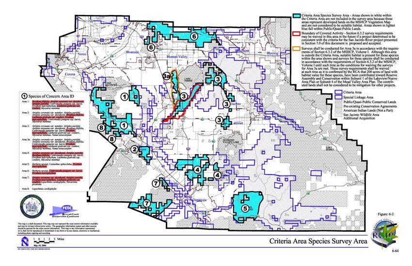
Governing Documents
• MSHCP documents - Volume I, Parts 1 and 2
  Contain all the primary implementing information
  and processes
• The Implementing Agreement (IA)
  Contract between the Permittees, the Wildlife
  Agencies (WA), and the RCA
• Permits – FESA Section 10(a)(1)(a) USFWS,
  NCCP from CDFG
• Permit Conditions includes requirements not in Plan
   e.g. Permit Condition No. 5 – clearing and MBTA Take
Documents and Tools
           MSHCP documents available online at:
         http://www.wrc-rca.org/document-library/

               Online information and mapping:
                 RCA MSHCP Information Tool
http://wrcrca.maps.arcgis.com/apps/webappviewer/index.html?
           id=a73e69d2a64d41c29ebd3acd67467abd

    Refer to the handout for How to Print a MSHCP Report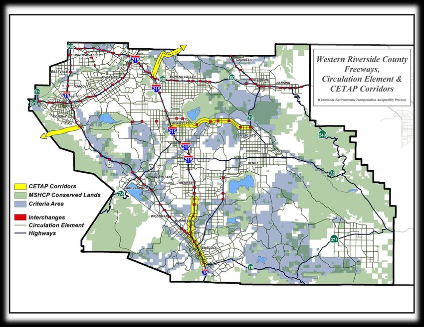
General MSHCP Background
• MSHCP is a Federal Habitat Conservation Plan
  (HCP) Under Section 10 of FESA and a State
  Natural Communities Conservation Plan (NCCP)
• MSHCP provides “take” &/or mitigation for 146
  species under FSA, CESA, and CEQA
• Long-term Plan – 25 years for Reserve Assembly
• Permits are for 75 years
• Reserve management in perpetuity
What does Covered Species Mean?
• Species Covered Adequately Conserved = Take
  under FESA/CESA is permitted and Mitigation
  under CEQA is fulfilled as long as project is
  consistent with the requirements of the MSHCP
  – Species w/out footnote in last column of Table 2-2
    Volume 1
  – No survey requirement, no species-specific
    mitigation required
     • EXCEPTION – Delhi Sands Flower-Loving Fly (will discuss
       later)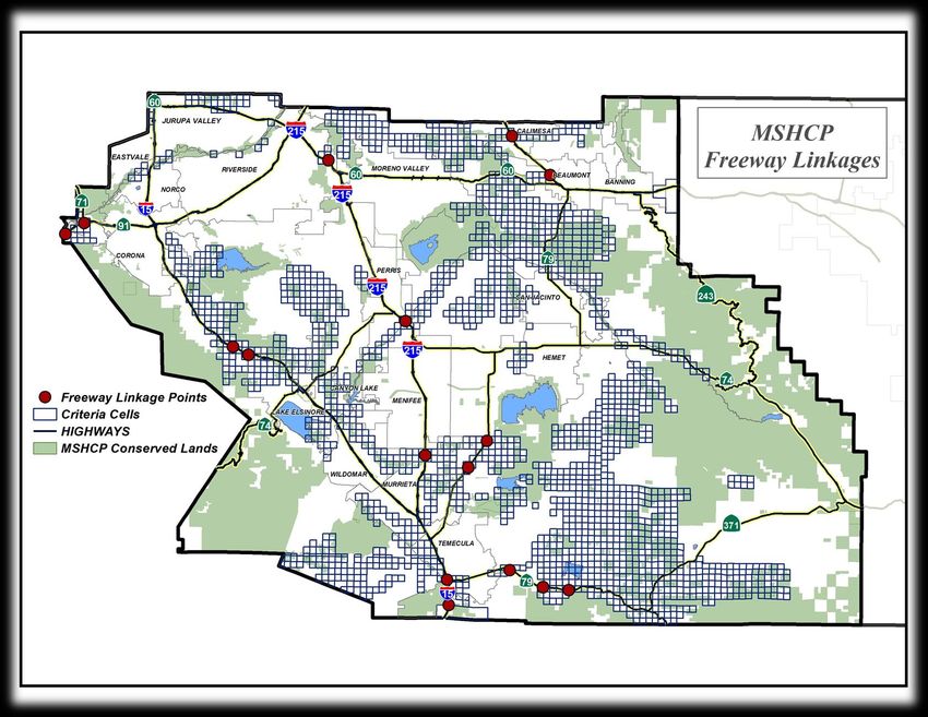
Covered Species but not Adequately
            Conserved
Until species-specific conservation measures are met,
these 28 species do not have take under FESA/CESA and
mitigation under CEQA is not provided. Two types:
• Species w/ mapped Survey Areas or Section 6.1.2 species (listed fairy
  shrimp, LBVI, SWWF, WYBC) are provided coverage through
  consistency with the MSHCP and mitigation through DBESP triggers
    – No long-term conservation value, no DBESP or mitigation required
    – Long-term conservation value, DBESP and mitigation provided until species
      conservation objectives are met
• Species w/ no mapped survey areas but will be adequately conserved
  once conservation requirements identified in species-specific
  conservation objectives have been in Table 9-3 in Volume 1)
    – Population size/occurrence has been conserved (e.g. Plummer’s mariposa lily)
    – MOU has been executed with the USFS (e.g. San Bernardino King Snake)
Covered Species “Take” Limitations
Table 9-3 Species Not Adequately Conserved
Take not available until named objective met:
California muhly Table 9-2 Objective 3
cliff cinquefoil Table 9-2 Objective 3
grasshopper sparrow Table 9-2 Objective 2
Lincoln's sparrow (partial) Table 9-2 Objective 3
Mohave tarplant Table 9-2 Objective 3
San Bernardino flying squirrel Table 9-2 Objective 2
chickweed oxytheca Table 9-2 Objective 3
fish's milkwort Table 9-2 Objective 3
Take available because named objective met (check annually):
✓ beautiful hulsea ✓ Parry’s spineflower
✓ Coulter's matilija poppy ✓ peninsular spineflower
✓ graceful tarplant ✓ Plummer’s mariposa lily
✓ small- flowered microseris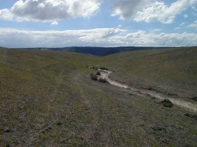
Covered Species “Take” Limitations
Table 9-3 –Species Not Adequately Conserved
Take not available without Forest Service MOU:
California bedstraw San Diego mountain kingsnake
California spotted owl shaggy-haired alumroot
Cleveland's bush monkey flower southern rubber boa
lemon lily southern sage brush lizard
ocellated Humbolt lily sticky-leaved dudleya
San Bernardino mountain kingsnake Williamson's sapsucker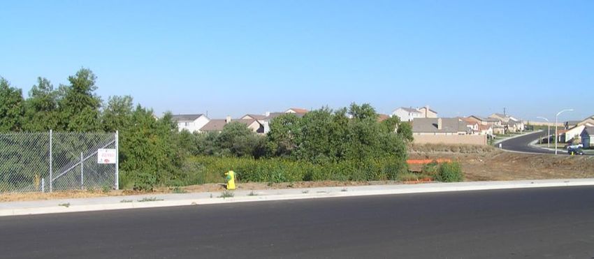
Species “Take” Limitations Take very limited or not available vs. Habitat Removal: Santa Rosa Plateau fairy shrimp Bald eagle* Golden eagle* Peregrine falcon * White-tailed kite* *State Fully Protected Species
Delhi Sands Flower-Loving Fly
• Refer to Figure 9-9 in Volume 1
  – Issue mostly focused in Jurupa Valley
• Refer to Species Objective 1B
• No suitable habitat
  – Provide evidence that no unconsolidated Delhi sands
    are present, regardless of disturbance
• Suitable habitat
  – 2 consecutive years of surveys
  – Must follow current USFWS protocol
SKR HCP vs. MSHCP
• The MSHCP provides take of SKR outside of the
SKR HCP fee area.
• Because Caltrans is not a permittee under the
SKR HCP, a take statement in the BO is needed:
– Map and provide take acreage of potential SKR habitat
– Measures needed to ensure avoidance of other
potential lands
– Bio monitoring during construction to monitor take
estimate is not exceededFESA Take on Federal Lands • USFWS performs streamlined internal BO that cannot require more than consistency with the MSHCP. • Take of designated Critical Habitat is mitigated through consistency with the MSHCP for those federally listed covered species • If on federal lands of a non-permittee (e.g. USFS, BLM), the agency consults with USFWS but can require more than USFWS requires. – For example: can require CAGN focused surveys.
CESA Take on Federal Lands
• CDFW requires consistency with the MSHCP
• Take of state listed species on federal lands
   – Consistency with the MSHCP
      • No 2081 is required
• Take of state and federally listed species on federal
  lands
   – Consistency with the MSHCP
   – Federal entity (e.g. USFS) – refer to preceding slide.
RCA Responsibilities • Administer MSHCP • Provide MSHCP implementation guidance for Permittees • Track Losses (grading/building) and Gains (acquisitions) = Rough Step • Collect Fees • Purchase and accept Conservation Land • Manage and monitor Conservation Land
RCA as a Resource
• Good working relationship with the Wildlife
  Agencies
• Review DBESPs and reports prior to Consistency
  Review submittal to ensure reports, surveys, and
  mitigation (if necessary) are adequate
• Provide assistance in review of reports, surveys,
  and mitigation for Projects outside of Criteria
  Area
• Assist in suggesting mitigation areas
Joint Project Review (JPR)

Improvements to Caltrans facilities are not
subject to JPR unless local agency sponsor
chooses, but are subject to State Permittee
  review process with Wildlife Agencies.
Caltrans Project Consistency Review
• Caltrans projects undergo State Permittee project
  review (MSHCP, pg. 6-84)
• Wildlife Agencies and Caltrans jointly review
  proposed projects both within and outside Criteria
  Area
• Caltrans submits project information directly to the
  Wildlife Agencies and RCA staff
• Wildlife Agencies staff or Caltrans staff may schedule
  a meeting to discuss a proposed project.
• RCA staff shall be invited to participate in this
  meeting.
Project Information for Consistency
              Review
• For the Consistency Review Process the following
  shall be submitted to Wildlife Agencies and RCA:
   – Project Description
   – Project footprint/preliminary engineering
      • On-site and off-site
      • Limits of Disturbance
         – Permanent vs. Temporary
   – Relevant MSHCP information (habitat assessments,
     surveys, maps of resources and impacts)
   – GIS files of project impact area (direct, temporary)
Caltrans Responsibilities • Purchase MSHCP Additional Reserve Land (ARL) as follows: – 2,000 acres in the eastern portion of the Plan Area – 1,000 acres in the western portion of the Plan Area •Endow or transfer and fund three positions in CDFG for management and monitoring of Additional Reserve Land
Covered Activities
Two Types
1. Covered Operation and Maintenance (O&M)
   Activities

2. Covered Roads (Freeway) Improvements
     o increase/enhance capacity
❖Covered Activity vs. Covered Species - not the same
 thing
Covered Operation and Maintenance
(O&M) Activities
• Signage • Grading Existing Dirt Roadways
• Traffic Control Devices • Dust Stabilization
• Guardrails and Fences
• Culverts/Drop Structures
• Pavement Repairs
• Curbs/Gutters/Sidewalks
• Accident Response
• Tree Trimming • Roadway Widening (not
• Natural Disaster capacity enhancing)
Damage/Restoration of Emergency • Berms
Access • Roadway Resurfacing
• Storm Damage
• Ditch Clearing (not jurisdictional
• Weed Control
waters/wetlands)
• Grading Shoulders (up to 12 feet
from the edge of paved or unpaved • Landscape Maintenance
roadways) • Bridge Maintenance
• Roadway ReconstructionCovered O & M Activities
in PQP or Criteria Areas
• O&M Activities in PQP Lands (Sec. 7.2.1)
– Required to comply with Appendix C BMPs
– Not subject to Sections 6.1.2, 6.1.3, 6.1.4, 6.3.2, or 7.5 of
MSHCP
– Cannot remove PQP w/out Replacement at 1:1
• O&M Activities in Criteria Cells (Sec. 7.3.4)
– Required to comply with Sec. 7.5.3, Construction
Guidelines and Appendix C BMPs
– Not subject to Sections 6.1.2, 6.1.3, 6.1.4, 6.3.2, 7.5.1 or
7.5.2 of MSHCPCovered O & M Activities
Outside Criteria Area and PQP
• Per Sec. 7.1, O&M activities are Covered Activities
not subject to MSHCP policies below by inference:*
– Sections 6.1.2, 6.1.3, 6.1.4, 6.3.2
– Section 7.5
– Appendix C BMPs
*No MSHCP text directly addresses O&M activities outside PQP and Criteria
Areas. Interpretation of MSHCP requirements for O&M activities in PQP and
Criteria Areas leads to the conclusion that the same activities outside these
areas would be Covered and subject to less stringent requirements.Covered Roads Activities
(non-O&M)
• Covered roads are subject to all Plan requirements
except reserve assembly
– Identified in Figure 7-1 in Volume I of the Plan
– Interstates, State Routes, CETAP, Interchanges
• Address MSHCP consistency in all CEQA and NEPA
documents
• Include mitigation measures/environmental
commitment where needed
– DBESP related mitigation (rip/riv, plants, BuOw, small mammals, VPs)
– Pre-con surveys for BuOw and nesting birds
– Implementation of wildlife undercrossing and direct fencing, if
required for project
– Construction fencing & monitoring of avoidance areasCovered Roads Compliance
• Comply with following Sections of MSHCP for all
Covered Road Activities (not O&M):
– Section 3.2.3 (Cores and Linkages within the MSHCP
Conservation Area)
– Section 6.1.2 (Riparian/Riverine Areas and Vernal Pools)
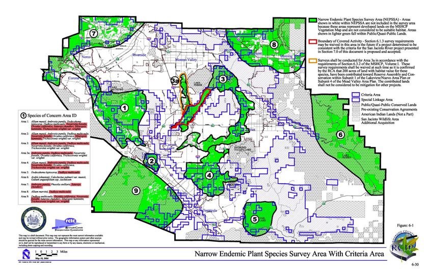
– Section 6.1.3 (Narrow Endemic Plant Species Survey Area)
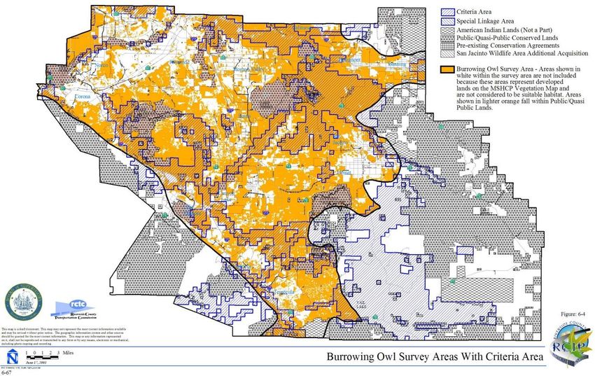
– Section 6.3.2 (Additional Survey Needs and Procedures
including Criteria Area Species Survey, Amphibian Species
Survey Area, Burrowing Owl Survey Area, Mammal Species
Survey Area)
– Section 6.1.4 (Urban/Wildlands Interface Guidelines)
– Section 7.0 and Appendix C of MSHCP (BMPs and the siting
and design criteria)Covered Road Compliance
Sec. 6.1.2 – Riparian/Riverine
• Applies to all Projects, even outside Criteria
Area
• Address all four potential areas of impact,
every time, all the time:
– Riparian Areas (generally CDFW jurisdiction)
– Riverine Areas (generally CDFW jurisdiction)
– Vernal Pools
– Fairy Shrimp (must follow current USFWS protocol)Riparian and Riverine
“…lands which contain Habitat dominated by trees, shrubs, persistent emergents,
or emergent moss and lichens, which occur close to or depend upon soil moisture
from a nearby fresh water source; OR areas with fresh water flow during all or a
portion of the year.”
• Riparian habitat is different from Riverine feature (evaluate separately)
• Riverine - natural in origin; also, past natural features that have been
heavily modified and/or redirected and features indirectly created through
man-made manipulation of the landscape.
• Evaluate features in context of formation and downstream connectivity; If
connect to “nearby” downstream resources that are either existing or
described conservation lands, impacts to them would need to be
mitigated.
• Even a manmade concrete channel connected to existing or described
conserved lands that was installed to redirect historic flows could be
considered valuable in supporting downstream habitat and species.Artificially Created Wetlands • Most artificial wetlands are NOT subject to MSHCP riparian/riverine (if isolated and unvegetated) but are still subject to other Section 6.1.2 requirements • Exceptions (i.e., these ARE subject to MSHCP): ➢ Wetlands created for mitigation ➢ Created open waters (i.e. Lake Perris) ➢ Wetlands created from the alteration of natural streams (i.e. managed marsh)
Vernal Pools

Seasonal wetlands that occur in depression areas that have wetlands
 indicators of all three parameters (soils, vegetation and hydrology)
 during the wetter portion of the growing season but normally lack
 wetlands indicators of hydrology and/or vegetation during the drier
   portion of the growing season…The determination that an area
    exhibits vernal pool characteristics, and the definition of the
  watershed supporting vernal pool hydrology, must be made on a
                           case-by case basis.
Covered Road Compliance
Sec.6.1.2 – Riparian/Riverine
• Always map Riparian and Riverine resources
• If different than CDFW jurisdiction, explain why
– E.g. Man-made in uplands
• Make sure a qualified biologist makes determination
• Make sure mapped riparian is equal to riparian vegetation
mapping. If different, provide explanation.
• Identify if impacts will occur or avoidance
• If project includes impacts to Riparian/Riverine, prepare DBESP
(Determination of Biologically Equivalent or Superior
Preservation) – regardless of long-term conservation valueCovered Road Compliance
Sec.6.1.2 – Riparian/Riverine
• If Project will impact suitable riparian, riverine, vernal pools or
fairy shrimp habitat, prepare focused surveys:
Least Bell’s vireo Southwestern Willow Flycatcher
Western Yellow-billed cuckoo Fairy Shrimp
• If focused surveys for species show impacts:
– Avoid 90% of long-term conservation value
• 90% of what? Due to ROW issues, prepare for mitigation, unless it
can be justified
– If not, prepare DBESP (Determination of Biologically
Equivalent or Superior Preservation)Covered Road Compliance
Sec.6.1.2 – Riparian/Riverine
• Typical DBESP Mitigation:
– Establishment
– Re-establishment
– Restoration
– Enhancement
– Preservation (can’t already be Conserved or intended to be
Conserved)
• RCA can offer assistance
– Limited RCA Reserve land available for mitigation use
– Can generally accept permitting agency required conservation
easements over mitigation sitesCovered Road Compliance Section 6.1.3 NEPSSA Survey Area
Covered Road Compliance
Section 6.3.2 CASSA Survey Area
Covered Road Compliance
Section 6.3.2 Burrowing Owl Survey Area
Covered Road Compliance
Section 6.3.2 Small Mammal Survey Area
Covered Road Compliance
              Section 6.1.3 & 6.3.2 Surveys
• Conduct focused surveys during blooming period or
  appropriate season
• Conducted focused surveys within one* year of MSHCP
  consistency determination
• If occupied habitat is going to be impacted, then identify area
  of long-term conservation value
   – Avoid 90% of long-term conservation value
       • 90% of what? Due to ROW issues, prepare for mitigation, unless it
         can be justified
   – If not, prepare DBESP (Determination of Biologically Equivalent
     or Superior Preservation)
Covered Road Compliance
Section 6.1.3 & 6.3.2 Compliance
• DBESP mitigation for Narrow Endemics, BOUW,
Amphibians and Mammals can include:
– Restoration
– Creation
– Relocation/Translocation
– Preservation
• Copies of ALL surveys should be submitted to
Biological Monitoring Program Administrator
(Melody Aimar at maimar@sawatershed.org)Covered Road Compliance
Section 6.1.4 -Urban Wildland Interface
Locations where development is near Conservation
Areas (future and existing) that may create edge
effects.
MSHCP Consistency document and CEQA document
should address:
- Drainage
- Toxics
- Lighting
- Noise
- InvasivesCovered Road Compliance
7.5.1 Guidelines for the Siting and Design of
Planned Roads in PQP/Criteria Area
• Applies to facilities where conservation land exists or is
expected to exist on both sides of the Covered Facility.
• Perform biological studies
• Located in the least environmentally sensitive location
Feasible
• Avoid impacts to Covered Species and wetlands to the
greatest extent Feasible.
• Avoid any construction, maintenance and operation activities
that involves clearing of natural vegetation during the
breeding season.Covered Road Compliance
7.5.2 Guidelines for Construction of Wildlife
Crossings
• Consider the function of the reserve feature that is being
traversed
• Consider wildlife movement needs for Planning Species.
Requirements for number and size of undercrossings
dependent on species.
• Use variety of crossings for different types of species depending
on length of road interface with conservation lands.
• Can accommodate wildlife movement using drainage culverts
with upsizing, directional fencing, and dry crossing ledges, etc.Covered Road Compliance
7.5.3 Construction Guidelines - Examples
• Similar to measures seen in Streambed Alteration
Agreements
– Limiting extent of disturbance
– Avoiding unplanned impacts to streambeds from
staging, diversion, erosion from fill
• Avoid habitat clearing during breeding season- March 1 to
June 30 (typically longer due to F&G Code)
• Regular construction watering
• Training of personnel
• Construction monitoring and reporting
• Proper waste handling and disposalCovered Road Compliance
DBESPs
• Identify resource, function and value
• Explain how project impacts the function and
value
• Say why you cannot avoid
• Provide mitigation addressing function & value
• Submit shapefiles of mitigation areas
• Provide to copy to Wildlife AgenciesCovered Road Compliance
DBESPs
• A DBESP is not a Consistency Document but is
necessary to demonstrate consistency with
the MSHCP
• Triggered when
• direct impact will occur to
– Section 6.1.2 resources
– Sections 6.1.3 and 6.3.2 species having long-term
conservation value
• Template available on RCA websiteCovered Road Compliance
DBESPs
• DBESP only needs to address that resources
triggering the DBESPDBESP Basics
• Chapter 1 provides the context and framework to support the DBESP
• Know the resource/species
– Hydrological functions and values (e.g. sediment transport, water conveyance,
ground water recharge, water quality, flood attenuation)
– Vernal Pool – map the watershed
– Biological functions and values – on-site and downstream resources
• Section 6.1.2 species (on- and off-site)
• Species connectivity
• Impacts
– Not all riparian/riverine resources are the same
– Be clear on what is being impacted in what way and for how longDBESP Basics
• Equivalent Superior Preservation
– Provide justification for why the mitigation being provided will compensate for
the quality and amount of resource proposed for impact.
• Stating it is sufficient does not justify why it is
– Impacts to MSHCP covered species/resources has to be addressed within the
Plan boundary.
– Cannot mitigation outside of Plan boundary (e.g. Santa Margarita Watershed)
– What is being proposed?
– When will the mitigation occur in relationship to the impact?
– Where will the mitigation occur?
– Who will manage the mitigation in perpetuity?DBESP Processing Information • DBESPs require 60-day review by Wildlife Agencies * • If Regulatory Permits needed, best practice to make sure DBESP is accepted by Wildlife Agencies *30 day review if project has participated in Pre-application DBESP/Permitting meeting and has agreement with WA on mitigation
Processing Information
                      Permits
• MSHCP does not remove regulatory permitting
  requirements or mitigation obligations
• 1602, 404 and 401 Permits still required if
  applicable
• Permit mitigation important to offset loss of
  MSHCP Riparian/Riverine
• If permits change mitigation, revise DBESP and
  submit copies to WA and RCA
Questions? Thank you!
You can also read