Catch the Hatch A Community Science Project - by the Left Hand Watershed Center Community Science Program
←
→
Page content transcription
If your browser does not render page correctly, please read the page content below
Catch the Hatch

A Community Science Project
 by the Left Hand Watershed Center
    Community Science Program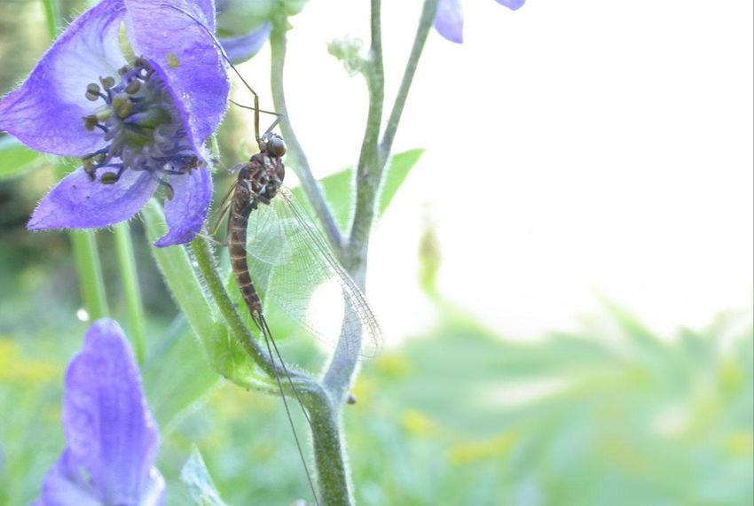
>
Catch the Hatch
            A Community Science Project

                      Volunteer Training Manual

                                      By:

                        Left Hand Watershed Center
                        Community Science Program
                             6800 Nimbus Road
                            Longmont CO 80503
                               ~June 2021 ~

                               Suggested Citation:

Hummel, D., Sorokin, Y, Olson, J., Newman, S., Scarpino, R., and Newman, G. 2021.
   Catch the Hatch: A Community Science Project. Volunteer Training Manual
      Left Hand Watershed Center, Longmont, Colorado 80503. 26 pages.

                                                                                    1
>

                                           2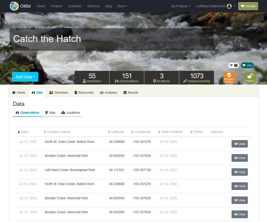
Table of Contents

PROJECT OVERVIEW                                                    5
  What Is Expected of Me?                                           5
  What Can I expect as a Volunteer from the Catch the Hatch Team    5
  Project Timeline                                                  6
RELEVANCE TO SCIENCE                                                6
  Mayflies and Pale Morning Duns                                    7
  Research Questions                                                7
PROJECT LOGISTICS                                                   8
  Sign Ups                                                          8
  Gear List                                                         9
  Observation Day Overview                                          9
  Catch the Hatch Protocol                                         10
  Datasheet                                                        13
  Technology and Data Entry                                        13
       Website Registration on CitSci.org                          14
       Data Entry Instructions for the Website                     18
       Data Entry Instructions for My Watershed app                24

                                                                    3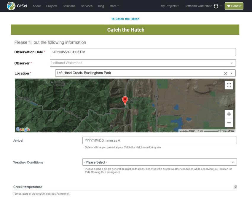
>

                                           4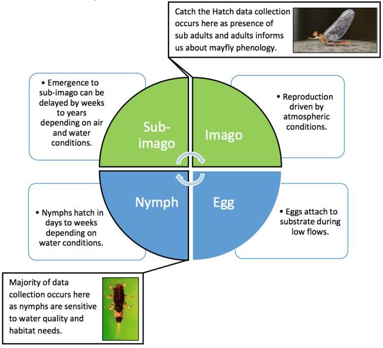
PROJECT OVERVIEW
The Catch the Hatch community science project will track mayfly emergence in Boulder, Left Hand, North
St. Vrain, and St Vrain Creeks to help inform watershed health. As you know, mayflies are sensitive to
pollution and changing climate. Many scientific organizations sample aquatic insects in streams to inform
water resource and land managers on changes in water quality throughout the region. However, so far it
has been difficult to track the emergence and adult phase of these insects. It is important for us to capture
these life phases as the emergence of mayflies is a critical life stage for reproduction and as a food source
for fish.

Thank you for joining us this summer while fishing, recreating and enjoying your watershed as a Catch the
Hatch volunteer! Your participation helps inform science! We will provide you with nets and sampling
tools to capture and identify emerging mayflies. This year we will be tracking the emergence of the Pale
Morning Dun, a mayfly species well known and loved by anglers and fish alike.

What Is Expected of Me?

As a volunteer contributor, you are expected to honor your time commitment and follow data collection
and input protocols throughout the project, as well as have all data entered and return gear and samples
upon project completion. Throughout the project, your time commitment includes signing up for one or
more observation days at sampling locations, visiting the sampling location on those days, and making
observations for a minimum of 30 minutes while you recreate on the creek. Data collection expectations
include having the appropriate project-provided gear to successfully capture, identify, and collect mayfly
observations. Data input expectations include filling out and storing a hard copy datasheet and entering
data online on the citsci.org website or using the My Watershed mobile application.

Upon completion of the project, you are expected to return project-provided gear and all stored mayfly
samples (labeled and stored in project-provided vials) to the Catch the Hatch team. You will be notified of
gear and sample return options by the end of the project.

What Can I expect as a Volunteer from the Catch the Hatch Team
As a volunteer contributor, you can expect updates and information from the Catch the Hatch team
throughout the project, as well as updates on how we use your data after project completion (analysis
and reporting). Your data will be used to address our annual research questions and contribute to multi-
year research questions and long-term data sets. This year’s annual research questions will assess the
accuracy of volunteer sub adult and adult Pale Morning Dun identification and the frequency and timing
of sub adult and/or adult Pale Morning Dun observations during their peak emergence at three different
creek locations. Our multi-year research questions compare presence of nymph and adult stages at these
creek locations and assess changes in observations during peak emergence in relationship to creek
temperature over time. Your data will also help develop and contribute to the National Phenology

                                                                                                           5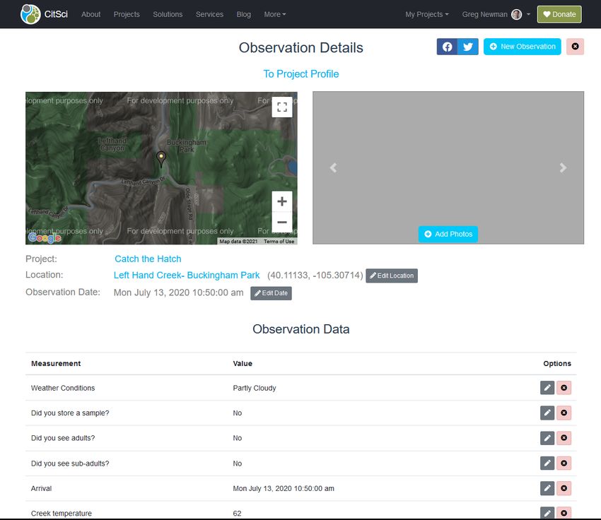
Network’s mayfly phenology database, which is a collaborative effort to monitor impacts of climate
change in the United States.

Project Timeline

The Catch the Hatch 2020 project will run from June 15 through July 15. Collectively, volunteer
contributors will visit each site once a day throughout this project period to record site conditions and
observe for sub adult or adult Pale Morning Duns. After July 15, all project materials and gear will be
collected and data will be analyzed and reported.

RELEVANCE TO SCIENCE
The life cycle of aquatic insects is complex and spans multiple environments. Throughout the life cycle,
aquatic insects occupy both aquatic and terrestrial habitats, and therefore, are sensitive to conditions in
both of these environments. However, our scientific understanding of these organisms is heavily focused
on aquatic life stages. The instream dwelling larval phase can last for years, while the adult terrestrial
phase lasts for a matter of hours to days. Because there are fewer environmental variables for the aquatic
larval phase, larval communities are commonly collected and analyzed as indicators of water quality
conditions. However, far less is known about the distribution and phenology of adult stages. Tracking the
emergence and flight of adult stages is not only critical for understanding population dispersal and
reproduction, but also for understanding their sensitivity to changes in watershed conditions and ongoing
climate change.

                                                                    In our Front Range creeks, flow
                                                                    speeds and creek temperature are
                                                                    driven by annual snowpack and melt,
                                                                    which in turn, influence the
                                                                    emergence patterns of aquatic
                                                                    insects. However, these watershed
                                                                    conditions are expected to change as
                                                                    a result of climate change. Our effort
                                                                    to track emergence patterns of
                                                                    sensitive species in relationship to
                                                                    changing flows and temperature over
                                                                    time will be an important indicator of
                                                                    watershed health and ecosystem
                                                                    function, and their sensitivity to
                                                                    climate changes.
                                                                                                         6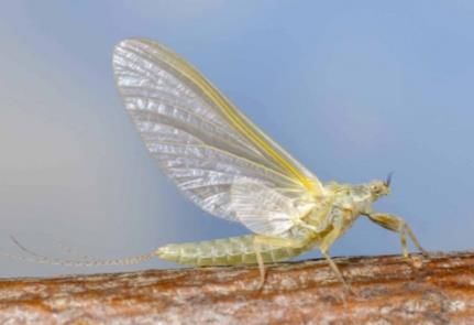
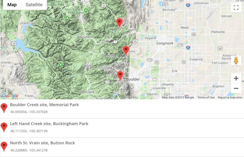
Mayflies and Pale Morning Duns

Mayflies are among the most sensitive groups to water quality and hydrologic conditions. Studies have
shown that their emergence is correlated to the higher creek temperatures that follow peak flows in
spring/early summer. The Pale Morning Dun (PMD) is well-known and easily identifiable species of mayfly
that is found in the transition zone of the Front Range. Coupled with the fact that it has a short window
of peak emergence compared to others mayfly species, PMDs are expected to be a strong indicator of
watershed conditions for our observation sites.

Research Questions

RQ1. Can trained community volunteers accurately identify sub adult and/or adult Pale Morning Duns
(Ephemerella dorothea infrequens) during their peak emergence from June 15 through July 15?

RQ2. What sampling time frame resulted in more correct observations of sub adult and/or adult Pale
Morning Duns?

RQ3. Are Pale Morning Dun adult and nymph life stages present in the same location from year to year?

RQ4. How does presence of sub adults and adult Pale Morning Duns during peak emergence change
over time in the transition watershed zone of Boulder, Left Hand, and North St. Vrain Creeks?

                                                                                                       7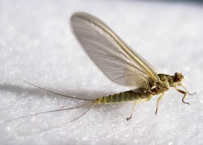
PROJECT LOGISTICS
As a volunteer for Catch the Hatch, you will use the following protocol and project-provided gear to collect
observational data and store any samples needed. Here, we provide specific instructions for how to make
observations, collect samples, and input data using a datasheet and the citsci.org Catch the Hatch project
data portal and/or the My Watershed mobile app. Throughout the project, you will be able to make
observations and track all project observations live!
(see: https://www.citsci.org/CWIS438/Browse/Project/Project_Info.php?ProjectID=2341)

Sign Ups

Use the project page to sign up for observation days. You are encouraged to sign up for multiple
observations! Simplified instructions on how to sign up for observation days are available on the Catch
the Hatch webpage.

(see: https://watershed.center/catch-the-hatch/)

As a volunteer, you will choose dates to visit sites on Boulder, Left Hand and North St. Vrain, and St Vrain
Creeks. If possible, we request that volunteers commit to more than one observation day from June 15
through July 15 to help cover all possible days for each month. Volunteers should give sign up priority to
days with no sign ups, however, multiple sign ups per day is fine. Collectively, our goal is to have one
volunteer signed up for each day between June 15 and July 15.
                                                                                                          8
Gear List
The Catch the Hatch Team will provide you with a Gear Kit and a list of items you need to bring. Please
keep track of these items, as they will be returned upon project completion.
Gear Kit Contents to bring:
1. Hard Copy Datasheet- found in this packet and provided
2. Catch the Hatch Protocol- found in this packet
3. ID Guide- provided
4. 3-Piece Collapsible Net- provided
5. Pre-filled Sample Vial and Labels- provided
6. Thermometer- provided
What you will need to bring:
1. Timer/watch/phone
2. Camera/phone
3. Pencil
4. Optional: My Watershed installed on your mobile phone
Observation Day Overview
This is a brief summary of an observation day. Please refer to the Catch the Hatch Protocol and Technology
and Data Entry instructions for more detail.
1. Prepare
Plan a time when you can visit a designated project site for at least 30 minutes. During this time, plan to
fish, recreate, and enjoy your watershed, while also keeping an eye out for mayfly emergence and record
observations.
2. Choose a Timeframe (or both!)
Visit a designated project site for at least 30 minutes between 11am and sundown to record observations
of Pale Morning Dun (PMD) adults or sub adults. If possible, give priority to observations during the Tier
1 timeframe. Please remember that observations of “No PMDs Present” are just as important as those
finding PMDs!
● Tier 1: 11am to 2pm. During this time, you will be looking for sub adults that have a characteristic
“pale” appearance.
● Tier 2: 2pm to sundown. During this time, you will be looking for sub adult or adult forms. Adults
have a darker appearance with clear wings.
An ID guide will be provided to all Data Catchers with images of PMD sub adults, adults, and look-alikes!
93. Collect Data
On-site data collection will include site information and photo, one water temperature measurement,
time-stamped observations of sub-adult and/or adult PMDs (if found), and one captured PMD sample (if
found) that will be stored in a project-provided vial. Data will be recorded on a hard copy paper datasheet
and subsequently entered online on the citsci.org Catch the Hatch project website here.
(see: https://www.citsci.org/CWIS438/Contribute/DataEntryForms/DataEntryForm.php?FormID=2391)
Catch the Hatch Protocol
Step 1. Prepare. Prior to an observation, you should complete some important preparation steps
listed below:
1. Register for Catch the Hatch project on citsci.org (see instructions under Technology and Data
Entry, Registration Instructions below).
2. Participate a virtual training event (either with instruction or self-directed)
3. Receive a gear kit by coordinating a pickup or delivery with project staff on the Project Page
(items listed in Observation Day Overview above)
4. Sign up for the creek site and observation date (see instructions under Sign Ups above)
5. Optional: download My Watershed app on your mobile phone.
Step 2. Choose a Timeframe. During preparation, plan a time when you can visit a designated
project site for at least 30 minutes. There are two possible time frames between 11am and sundown to
record observations of PMD adults and sub-adults. If possible, give priority to observations during the
Tier 1 timeframe.
Remember that observations of “No PMDs Present” are just as important as those finding PMDs!
● Tier 1: 11am to 2pm. During this time, you will be looking for sub-adults that have a characteristic
“pale” appearance (see ID guide).
Sub-adults may be emerging from the creek’s surface, a time when they are metamorphosing
from larvae (nymph) to sub-adult. They are also vulnerable prey to fish- makes good fishing!
You may also find sub-adults flying from creek shoreline, where they will rest and morph into full
adults. Even if you don’t see them actively emerging, be sure to check the shoreline substrate and
vegetation for resting sub adults or adults.
● Tier 2: 2pm to sundown. During this time, you will be looking for sub-adult or adult forms. Adults
have a darker appearance with clear wings.
Sub-adults or adults may be found along substrate or vegetation. You may also find adults flying
in the air as they prepare to mate. After mating, females will return to the water’s surface to lay
their eggs. They will be vulnerable to predators one last time!
10Step 3. Navigate to Observation Site. The Catch the Hatch webpage provides coordinates,
navigation option, and written out instructions on how to get to each creek location.
(see: https://watershed.center/catch-the-hatch/)
To review: creeks, site names, coordinates, and simple instructions are listed below:
1. Boulder Creek- Memorial Park: 40.005056, -105.337028
From Eben G. Fine Park on Boulder Canyon Drive, continue up Boulder Canyon Drive for 3 miles.
After driving through tunnel, turn Left onto pull off. Site location includes entire section of creek
accessible from the park pull off. Follow instructions on protocol upon arrival.
2. Left Hand Creek- Buckingham Park: 40.111333, -105.307139
From US-36 W in Altona, turn Left onto Lefthand Canyon Drive for 2.5 miles. Turn right into
parking area at Buckingham Park. Site location includes entire section of creek both upstream
and downstream of parking lot. Follow instructions on protocol upon arrival.
3. North St. Vrain Creek- Button Rock: 40.228889, -105.341278
From Lyons, head northwest on US-36 W for 4 miles. Turn Left onto Longmont Dam Road for 3
miles. Parking area for Button Rock will be on your left. Site location includes entire section of
creek accessible from the parking lot. Follow instructions on protocol upon arrival.
Step 4. Make an Observation and Record Data.
Remember to always use a paper datasheet and store photos on your phone or camera! Then, after
returning to your computer or cellular connectivity, enter data to the website and/or My Watershed
app.
A. Record site information. Upon arrival, record the following site information and data:
● Recorder (datasheet only)
● Date
● Site Name: Boulder Creek- Memorial Park, Boulder Creek- Eben. G. Fine, Left Hand
Creek- Buckingham Park, North St. Vrain Creek- Button Rock, St. Vrain Creek- Bohn Park
● Arrival Time: date and time
● Weather: clear, hail, wind, rain, overcast, partly cloudy
B. Take a site photo. Take a landscape photo that captures both edges of the creek using your
mobile phone. Please take and store all site photos locally to your phone or camera and upload
with your data on the website or My Watershed app later.
C. Take a creek temperature and record. During your site visit, take one water temperature
measurement. Submerge and leave you thermometer in slower moving water, or a place it will
11not wash away. Leave the thermometer submerged for 5-10 minutes. Record temperature
reading.
D. Observe for PMDs. While you fish, recreate, and enjoy your watershed, look on the water’s
surface, vegetation, and substrate for sub-adult and adult PMD. Remember that depending on
the time of day, you may see sub-adults or adults emerging, resting, or flying. See Step 2.
instructions for further details.
If you see mayflies or any insect you suspect may be a PMD, please use your aerial net and ID
guide to capture and identify.
E. Record observations. If you do not observe and/or capture and identify adult or sub-adult
PMDs during your site visit, then record ‘No’ for visual observation data next to both adult and
sub-adult life stages and ‘No’ for sample storage.
If you do observe and/or capture and identify adult or sub-adult PMDs during your site visit, then
record ‘Yes’ for visual observation data and the observation time next to the applicable the life
stage, adult or sub-adult. If your PMD was captured and identified, then proceed to Step 5.
instructions before you end your observation.
We would like a captured sample for all recorded ‘Yes’ observations! Try your best to limit ‘Yes’
observations without capturing, identifying, and storing a sample.
F. End your observation. After you have finished making observations and enjoying your time on
the creek, record your time of departure. Your departure time is when you leave the creek site-
this can be hours after a PMD observation!
Step 5. Sample storage and photo. If you have captured and identified an adult or sub-adult
PMD, then take a photo of the sample and carefully transfer it into a project provided vial for storage until
the end of the project. Multiple samples per vial are welcome! You can take a photo before or after placing
it in the vial- or both. The citsci.org website and My Watershed app can upload multiple photos.
Using a strip of paper (use post-it note, Rite in the Rain, or card stock; printer paper will degrade) and
pencil, label your sample with the site name, date, and time. Place the paper label into your vial and screw
your cap on tightly.
<
Please store your vials in a cool, safe place! They are filled with 80% ethanol solution. We
recommend storing vials in the plastic bag for safe keeping in and out of the field.
While making observations, be sure to fill out the datasheet below. Then upload data on the citsci.org
website or the My Watershed app. Additional copies of datasheets will be provided depending on your
observation needs.
12Datasheet
Technology and Data Entry
As a volunteer for Catch the Hatch you will use multiple forms of technology to collect and enter data so
we can ensure excellent data quality and storage and avoid any accidental data loss. Above all, we ask you
use and store a paper datasheet to enter data of your observations each day (the datasheet is provided
in this manual and your packet). You may then transfer your hand-written data directly into the online
datasheet on the citsci.org website or the My Watershed app that will upload your observation to our
project website on citsci.org.
Below are: 1. Website registration instructions (must complete before and observation for either data
entry option), 2. data entry instructions using the website after a site visit, and 3. data entry instructions
using the My Watershed app (with Android screenshots, iOS are similar).
13Website Registration on CitSci.org
Step 1: Before heading out to make observations, create your account on the
website, CitSci.org.
Important 2021 Update: Citsci.org is undergoing a facelift! We anticipate a new website launch June
10-13, 2021. If you are a returning volunteer: you will be asked to create a new password once the
launch is complete. If you are a new volunteer: we recommend waiting until AFTER the launch to
create to
Navigate your
theaccount,
website otherwise you will
https://citsci.org also
and beon
click asked to update
the “Sign your password
Up” button afterpage.
on the home the update!
areturnapp.
Fill out the registration information and click Submit. You will receive an email with a link that you must
click to validate your email.
1415
Step 2: Join the “Catch the Hatch” project
Once you’ve validated your email address and logged in, find the “Catch the Hatch” project by clicking
on the “Projects” link in the navigation bar.

In the search bar, type in “Catch the Hatch”, then click the “Ask to Join”.

Your request to join will be submitted and the button will switch to say “Pending Approval.” An email
will be sent to the project manager notifying them of your request. You will also receive an email
entitled “Thank you for requesting to join the Catch the Hatch project”. Once the project manager

                                                                                                         16
approves your request, you will receive an email notifying you that your request to join catch the Hatch
has been approved.
17Data Entry Instructions for the Website
Make sure you have completed steps 1 & 2 from the Website Registration Instructions above before
entering data with the website.
Step 1: Log in to the website, citsci.org, and go to the Catch the Hatch project
page
Navigate to https://citsci.org, and log in. Once logged in, click on the “My Projects” dropdown in the upper
right corner of the website and select “Catch the Hatch”. This will take you to the main project page seen
below.
18Step 3: Access the Catch the Hatch datasheet and enter data
Click on the “Add Data” button to go directly to the form to submit data. Enter the following data:
● Date of Observation: Date of observation, Recorder (should show your name).
● Location Information: select your observation location from drop down menu.
● Enter Arrival Time, Weather Conditions, Creek Temperature, Adult and Sub-Adult observations
and times (if observed), whether you stored a PMD sample or not, and Departure Time.
● Photos: upload all observation photos including site photo and photos of captured adult or Sub-
Adult PMDs.
1920
Step 4: Review the observation data you’ve entered
Check all entered data points. Then, click on the “Submit” button at the bottom of your datasheet. Once
you submit and observation, you will be taken to the “Observation Details” page below, where you will
have the ability to review or edit your submitted data.

                                                                                                    21
Step 5: View the project’s main profile page on the website to confirm your data
has been submitted properly or view all data submitted to the project
Navigate to “https://citsci.org”, and log in. Once logged in, click on the “My Projects” dropdown in the
upper right corner of the website and select “Catch the Hatch”. This will take you to the main project page
seen below.
Click on the “Data” tab to view a list of all observations submitted to the project. You should see your
observation at the top of the table (first row) because it will be the most recent observation submitted.
Click the “View” button at right corresponding to your observation.
After clicking on the observation’s “View” button, this will take you to the same “Observation Details”
page you saw before, displaying the data you entered. Here, you will be able to view your observation on
a map and have the ability to edit or delete any of the data you’ve entered.
2223
Data Entry Instructions for My Watershed app
Make sure you have completed steps 1 & 2 from the Website Registration Instructions above before
entering data on the My Watershed app.

Due to some glitches (that are currently being worked on), please fill out a paper datasheet and store
photos locally to your phone while in the field. Then, when you return to connectivity, you can upload data
and photos to the app’s datasheet.

Step 1: Download and install the My Watershed mobile app
Before heading to the field, search for and install the My Watershed mobile app from the Google Play or
Apple app store.

Step 2: Sign in to the app and let it automatically sync projects & datasheets
Use your registration credentials from citsci.org to log in. The app will ask you to “Authorize Access” - click
“Allow”.

 You must always log in to the My Watershed app before use. If you fail to log in before uploading data,
 you may incur an upload error or be asked to log in before an observation upload.

                                                                                                            24
Step 3: Select “Catch the Hatch” project from the project list and “Catch the
Hatch” datasheet from the datasheet list
Step 4: Select “Catch the Hatch” datasheet, upload data and photos, save the
observation, and submit/upload it to the website.
Once you’ve selected your project and datasheet on the mobile app home screen, click on the “Add
Observation” button to take you to the datasheet. You will see 3 tabs on the datasheet labeled “Main”,
“Species”, and “Site Data”. NOTE: you will not be entering any data in the “Species” tab.
Under the “Main” tab, you will need to fill out the following data:
● Date of observation
● Comments (if applicable)
● Photo: upload site photo(s) and a photo of sampled PMDs in your net or vial (if applicable)
● Location Information: select your observation location from drop down menu
Under the “Site Data” tab you will fill out the following data:
● Arrival Time, Weather Conditions, Creek Temperature, Adult and Sub-Adult observations and
times (if observed), whether you stored a PMD sample or not, and Departure Time
Once all data are filled out and all photos are uploaded, click the “Save Observation” button. Clicking this
button will save the observation to your phone, but will not yet submit the observation to the website.
25After you save your observations you will return to the “Catch the Hatch project page. You may then click
on “My Observations”, highlight the observation you would like up upload to the website, click upload (on
iOS, please upload one at a time).
26Step 5: View the project’s profile page on the website to confirm your data has
been submitted properly or view all data submitted to the project
Navigate to https://citsci.org, and log in. Once logged in, click on the “My Projects” dropdown in the upper
right corner of the website and select “Catch the Hatch”. This will take you to the main project page seen
below.
Click on the “View Data” tab to view a list of all observations submitted to the project. Then click the
“View” button corresponding to your observation.
After clicking on the observation’s “View” button, this will take you to the “Observation Details” page,
displaying the data you entered. Here, you will be able to view your observation on a map and have the
ability to edit or delete any of the data you’ve entered.
2728
You can also read