Understanding How NYS GIS and Open Parcel Data Sharing Can Benefit Counties - NYS GIS Program Office
←
→
Page content transcription
If your browser does not render page correctly, please read the page content below
Understanding How NYS GIS
and Open Parcel Data Sharing
Can Benefit Counties
NYS GIS Program Office

January 2021                   Kate Kiyanitsa, GISP
                                          NYS GIS Program Office
                           Statewide Parcel Map Program Manager
                                                   (518)-242-5041
                                    Katherine.Kiyanitsa@its.ny.gov
January 2021                                    2

               Jeanette Stanziano
               Director, Education & Training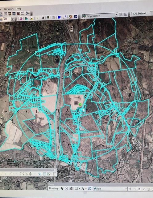
January 2021                                                                                           3

 NYSAC Thanks the
 Following Sponsor of
 Today’s Webinar:

 Contact:
 Brendan Baxter
 Vice President
 KeyBanc Capital Markets
 518-257-8501
 Brendan_E_Baxter@Key.com
                            Our deep New York government expertise allows us to bring valuable services and
                            actionable ideas to our clients. We're ready to help guide your County toward its
                            strategic goals through customized financial solutions.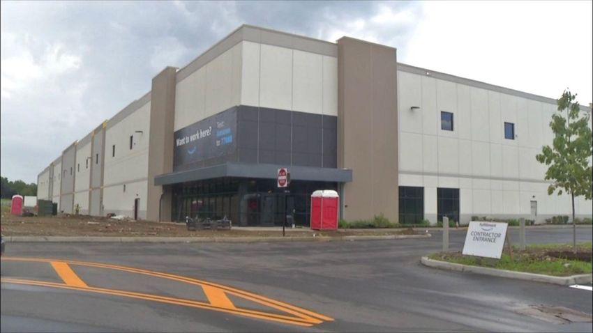
Kate Kiyanitsa, GISP
                          NYS GIS Program Office
           Statewide Parcel Map Program Manager
                                   (518)-242-5041
                    Katherine.Kiyanitsa@its.ny.gov

January 2021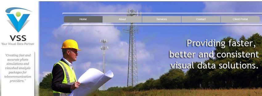
January 2021                                                                                                             5

                                          Geographic Information Systems (GIS)

    NYS GIS Program Office (GPO) Framework Data                                         Business Data Layers

                                           Tax Parcels                                        Incidents, Events, 9-1-1
                                           Streets & Address                                  Environmental Assets
                                                                                              Flood Zones
                                           Boundaries
                                                                                              Fleet Vehicles
                                           Elevation                                          Utilities
                                           Ortho Imagery                                      Wetlands

                                          Intelligence derived from location analysis
               Which properties suit my needs?   Which school am I closes to?   Where will the water flow?

                                                                                                                         5
January 2021                                                               6

The NYS Statewide Parcel Map Program

  Our mission is to       ,                                            ,
          , and                  to
  statewide tax parcel GIS data.
  We collect every county’s GIS tax parcel polygons once a year and
  standardize them using tabular assessment data from the NYS
  Department of Taxation and Finance Office of Real Property Tax
  Services. We share this standardized GIS data product as widely as
  each county allows. http://gis.ny.gov/parcels/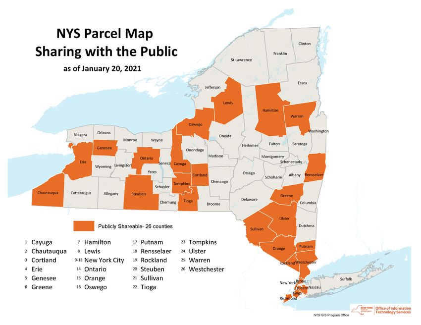
January 2021                                                                              7

Standardized Parcel Data
 It is necessary for users of parcel
 data across multiple counties to
 reconcile the differences in attributes
 and field naming conventions.

                    County   County   County   County   County
 Attribute Needed
                      #1       #2       #3       #4       #5
Municipality                                                     This is the work the NYS
                                                                 GIS Program Office does
Owner
                                                                 to combine all the
Mailing Address                                                  counties’ parcel data in a
Property Class                                                   common schema.
Year Built
January 2021                                                                     8

    Sharing Standardized Parcel Data
    While we encourage counties to open their parcel data publicly, we
    respect each county’s right as the data owner to control the distribution
    their GIS data. We will only share your data as the county directs us.

          GIS Program Office, Emergency
         Preparedness/Response, CIRIS*,                            62
          and State Agency Business Use                            (all counties)

                                 Publicly Available           26

*CIRIS: Critical Infrastructure Response Information System
January 2021                                                                           9

Thank you for your yearly updates- Even when you do not share your GIS parcel data
publicly, providing timely yearly updates to the NYS GIS Program Office ensures that the
following critical services (and much more) are always using the most current parcel data:
    •   State Police – use parcels in the their computer aided
        dispatch (CAD) systems to assess property boundaries and
        ownership on 911 calls

    •   Department of Corrections– use the parcel boundaries in
        the State’s Critical Infrastructure Response Information
        System (CIRIS) application to ensure sex offenders are
        housed at a legal distance from schools

    •   Office of Emergency Management/Dept of Environmental
        Conservation – use parcels for natural disaster planning
        and response, such as flooding and high-risk dam
        assessments. Federal aid for disasters has been secured for
        localities within a much shorter time window when current
        data is on hand in case of an emergency.
January 2021                                       10

 Open Access Parcel Data        Do counties miss out
           as of January 2021
                                when their piece of
                                this puzzle is absent?
January 2021 11
Distribution of Mapping Data Through Time
Print Burn Click
< 1980 2000 2020
Paper Maps Files on Disc DownloadJanuary 2021 12
Click Get Happy
D
o
w
These days it is n
expected that you l Connect with Web Services
can get almost o
everything online at a …Why not parcel data too?
the click of a button... dJanuary 2021 13
Obtaining GIS Parcel Data in New York
County GIS Tax Parcel Data Access
Internet searches on Phone calls to
Restricted multiple websites multiple offices
Public
Download or Charge $
26 counties 36 counties
In-person visits, Written agreements
42% witness notary and/or FOIL
58%
Requests & data Data may
may need to be cost $ to access
physically mailedJanuary 2021 14
Assessment Information is already
Publicly Available in some formats
Parcel centroid points with
assessment information from the NYS
Department of Taxation and Finance
Office of Real Property Tax Services
are publicly available. Assessment
information is also available in posted
local Tax Rolls. Attributes include
owner names and parcel addresses.January 2021 15 Source: https://govt.westlaw.com/nycrr/Document/I6b0842583e2d11e2bddd0000845b8d3e
January 2021                                                                                              16

     New York Consolidated Laws, Real Property Tax Law - RPT § 1588. Posted tax roll
     Notwithstanding any provision of law to the contrary, information regarding date of payment of taxes, the
     receipt number and related information need not be posted on the tax roll or other printed record of
     payment if that information is entered into the data file and retained by means of electronic data
     processing. This information must be stored so that it can be made readily available to the
     public in legible form. At the conclusion of the period for the redemption of property from taxes which
     become a lien on such roll, a copy of the posted tax roll shall be produced in either a paper format or
     archival quality microform and be permanently retained as a public record.

     Freedom of Information Law (FOIL) - Article 6 § 84-90 of the NYS Public Officers Law
     Real Property Data is subject to the FOIL process.

Sources:
https://codes.findlaw.com/ny/real-property-tax-law/rpt-sect-1588.html
https://www.dos.ny.gov/coog/foil2.html
https://tax.ny.gov/help/contact/foil_requests.htm
January 2021 17 Most Counties offer an Online Parcel Viewer http://gis.ny.gov/parcels/#parcel
January 2021                                                                                                                                                   18
The GPO examined the online budgets of 15 counties that received revenue for budget items which likely included the sale of GIS tax parcel
data. These numbers may include the sale of other tax map data products as well. In 2015, the average revenue budgeted by these counties
for tax map/parcel data was $9,700. In 2020, the average revenue was $7,200. Average decrease in revenue of -33% during this time. If you
only include counties that continue to receive revenue for parcel data in 2020 the figures are: $10,900 in 2015, $9,000 in 2020, and an average
decrease of -17%. See the following page for more detail and links to the information included in this graph.
                        $30,000                                                                                           60%
                                                                                                    increased revenue
                                                                                                                          40%

                                                                                                                                  % change in budgeted revenue
                        $25,000
                                                                                                                          20%
 budgeted revenue ($)

                        $20,000                                                                                           0%
                                                                          decreased revenue
                                                                                                                          -20%
                        $15,000
                                                                                                                          -40%

                        $10,000                                                                                           -60%

                                                                                                                          -80%
                         $5,000
                                                                                                                          -100%

                             $-                                                                                           -120%

                                         % Change from 2015 to 2020   2015 Budgets   2020 Budgets
January 2021 19
Online County Budget Details:
Tax Map Data Tax Map Data
Sales Sales Change from
County 2020 link to Budget Revenue Item(s) in Budget (2020)
(per 2015 County (per 2020 County 2015 to 2020
Budgets) Budgets)
Albany $ 25,500 $ 24,000 $ (1,500) Albany County 2020 Budget p.152 ("Tax Map Reproduction Charges" + "Tax Map Charges")
St Lawrence $ 18,700 $ 17,700 $ (1,000) St Lawrence 2020 Budget p.133 ("Imagemate Online fees" + "R LR Sale of Tax Maps" + "RP Salesnet")
Cattaraugus $ 12,500 $ 11,500 $ (1,000) Cattaraugus 2020 Budget p.22 (Real Property "Sales, Other, Sale of Maps/Supplies")
Chenango $ 12,000 $ 10,000 $ (2,000) Chenango County 2020 Budget p. 4 ("Sale Of Tax Maps")
Madison $ 12,000 $ 6,150 $ (5,850) Madison County 2020 Budget p. 20 ("Digital Processing Fees" + "Sale of Tax & Survey Maps")
Essex $ 10,000 $ 8,000 $ (2,000) Essex County 2020 Budget p. 440 (2020 Tentative Budget, "Sale of Tax Maps")
Rensselaer $ 10,000 $ - $ (10,000) n/a opened up GIS tax parcel data publicly since 2015
Delaware $ 8,500 $ 7,000 $ (1,500) Delaware County 2020 Budget p. 11 ("Minor Sales- Electronic" + "Minor Sales Files")
Dutchess $ 8,000 $ 6,500 $ (1,500) Dutchess County 2020 Budget p.193 ("Assessor Fees Maps & Aero Photos: Sale of maps, aerials and assessment data")
Steuben $ 7,800 $ 4,300 $ (3,500) Steuben County 2020 Budget p. 53 ("Tax map sales" + "Sales- Geogrpahic Info Sys"); opened data publicly in 2020
Allegany $ 7,000 $ 4,000 $ (3,000) Allegany County 2020 Budget p. 56 (Assessments "Sales- Other")
Schenectady $ 5,000 $ 4,000 $ (1,000) Schenectady 2020 Budget p. 270 ("Minor Sales- Tax Mapping")
Monroe $ 4,000 $ 5,000 $ 1,000 Monroe County 2020 Budget p. 155 ("Map Copies and Overlays")
Warren $ 2,500 $ - $ (2,500) n/a opened up GIS tax parcel data publicly since 2015
Rockland $ 1,800 $ - $ (1,800) n/a opened up GIS tax parcel data publicly since 2020
Average: $ 10,917 $ 9,013 $ (1,904) NOT including the counties that opened up their GIS tax parcel data
Average: $ 9,687 $ 7,210 $ (2,477) Including the counties that opened up their GIS tax parcel data
GIS parcel data revenue is likely only a portion of these sales figuresJanuary 2021 20
Managing requests Handling requests
online or via email on phone calls $9,000 average revenue
to maintain this data
Staff time on filling Written agreements or delivery system (which
data requests FOIL and legal costs
has its own inherent
costs) ….OR….
Filling data delivery Mechanisms for
via physical mail exchange of $January 2021 21 What happens when a county says YES to sharing GIS tax parcel data publicly, at the click of a button?
January 2021                                                                            22

                   County Parcel Downloads on GIS.NY.GOV
                  3,000
                                                              2,730
                  2,500                                               We examined the
                                                                      number of downloads
                  2,000                                               for three counties that
 # of downloads

                                                                      unlocked their parcel
                  1,500
                                                                      data in 2015. The
                  1,000                      907                      number of downloads
                               648                                    drastically increased
                   500                                                after opening up the
                          57            61              127           data to the public.
                     0

                           Tioga        Greene      Rensselaer

                               Locked        Unlocked
January 2021 23
Rensselaer County Parcel Data Downloads by Sector
Looking more closely at
Rensselaer County, we
examined the IP addresses
of those downloading the
data to determine who was
accessing the data
?January 2021 24 Types of Businesses that Downloaded Data
January 2021                                  25

     Examples of Specific Businesses that
  downloaded open parcel data on GIS.NY.GOV
               Projects and priorities that
                benefit local economies
January 2021 26
Economic Development
Amazon downloaded Rensselaer County
GIS tax parcel dataJanuary 2021 27
Amazon Warehouse Facility has just been
built in Schodack bringing:
• 800 full time jobs with benefits, and up to $3,000
tuition assistance per year for 4 years
• Property Tax estimates over the next 20
year period after taking into account the
cost to the town: $1.5 million per year
(previously $15,000 for the property)
✓ Town of Schodack average annual, would get
$206,000
✓ Water district- $21,000
✓ Sewer district- $13,000
✓ Ambulance- $9,000
✓ Fire district- $45,000
✓ East Greenbush School District- $1.25 million
Source: https://www.schodack.org/node/261/minutes/2018
https://www.schodack.org/node/24/minutes/2018January 2021 28 Regeneron Temple Lane, East Greenbush Pharmaceutical Science Building, Manufacturing, and Warehouse being built now. Engineering companies working on the site downloaded the publicly available parcel data. ✓ 1,500 jobs (salary range $45,000-$110,000) ✓ Creating medicine to treat: eye disease, allergic and inflammatory diseases, cancer, cardiovascular and metabolic diseases, pain, rare diseases, and infectious diseases like Ebola and COVID-19. Sources: https://www.timesunion.com/business/article/Regeneron-plans-to-add-1-500-in-East-Greenbush-13221059.php; https://www.eastgreenbush.org/departments/planning-zoning/apps/regeneron-tempel-lane-phase-3
January 2021                            29

               Citizen Engagement
     GIS-powered opposition to the Amazon
             project in Schodack
January 2021 30
“484 parcels that intersect the
Amazon parcel within 1 mile. The
green dot is the blasting coordinate.”
Local citizens downloaded the publicly
available parcels for Rensselaer County to
quickly act on their concerns about the
development. Blasting at the Amazon site
was rescheduled after the neighbors used a
map analysis of parcel data to remind the
town about the law that stated all residents
had to be informed and allowed to request
a pre/post inspection.January 2021 31
Environmental Protection
Forest and wildlife preservation and
sustainable energy companiesJanuary 2021 32
The Conservation Fund
Cowee Forest traps more than 2.2 M tons of
CO2 from the atmosphere-equivalent to
removing 471,000 passenger cars from the
road for one year
Contributes to the local economy by
supporting 102 jobs in Vermont, 102 jobs in
Massachusetts and 101 jobs in the state of
New York
Conserves 59 miles of streams, and filters
nearly 27B gallons of water annually
Conserves habitat for seven species of
national importance, like the New England
cottontail, and four hawk species listed by
the New York State Endangered Species Act
https://www.conservationfund.org/projects/cowee-forest; 2017 Project
Protects 5,442 acres for public accessJanuary 2021 33
Virtual Site Simulations
ʺ…data analysis applications for commercial construction, windmill and solar engineering…ʺ
http://virtualsitesimulations.com/about.htmlJanuary 2021 34
And Many More…
• Broadband Internet Access Expansion
• Historic and Cultural Preservation
• Research Laboratories
• Application Developers
• Small Business DevelopmentJanuary 2021 35 We hear from businesses and residents… • I’ll just keep using the old data I have for now. • I lose too much time and money for my business having to track this data down. • Let us know when more of the data is public. We’ll only use what’s available now until then. • I don’t understand why I have to pay when I’m using it to do something good for the county. • I can get this for other States, why not here?
January 2021                                                   36

We hear from NYS Empire State Development…

  “One premier site selection firm, that has
  sited numerous large-scale projects in NYS,
  expressly told [us] that communities have
  been excluded from consideration because
  this information was not easily available to
  the site selector.”
   - Strategic Business Division of Empire State Development
January 2021 37
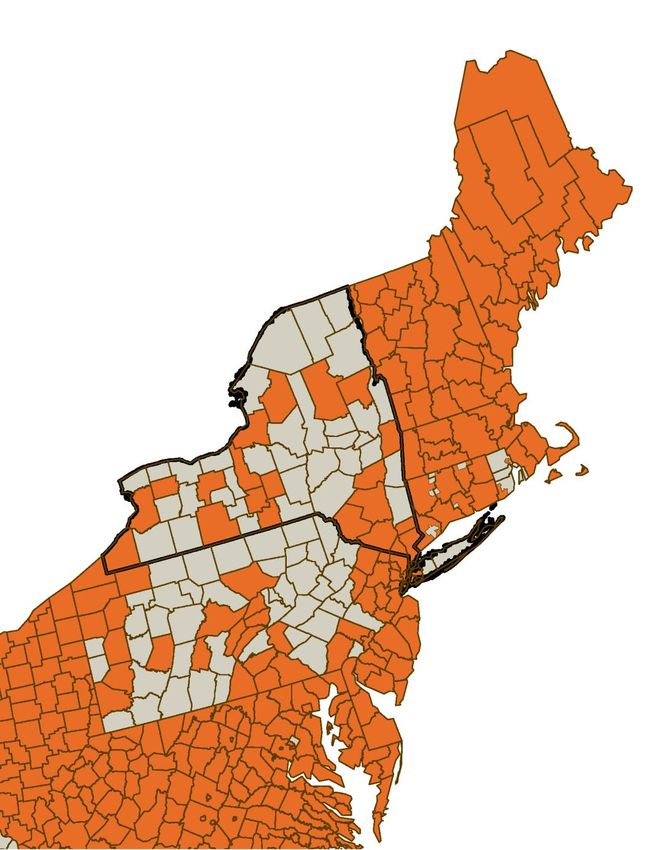
Northeast Regional Map of
Open Parcel Availability
Economic opportunities,
jobs/services, and
innovation requiring open
and fast access to parcel
data can easily go elsewhere
in our region….January 2021 38
Relatively
small (& falling)
False sense Outmoded
amounts
that people
of revenue data delivery
Help put authoritative will pay/wait
for data
mechanisms
GIS parcel data in the
hands of job creators,
researchers, and
innovators.
Don’t miss out!January 2021 39
The New York State GIS Program Office has the
technical capability already in place to make
your county’s parcel data accessible in one-click
via data download and web services.
Just SayJanuary 2021 40
Click Get Happy
D
o
w
Is it beneficial n
to open l Connect with Web Services
access to o
a …The decision is up to you.
parcel data?... dJanuary 2021 41
Thank You!
GISBoundaries@its.ny.gov Kate Kiyanitsa, GISP
NYS GIS Program Office
(518) 242-5041
Katherine.Kiyanitsa@its.ny.govJanuary 2021 42
NYSAC Thanks the
Following Sponsor of
Today’s Webinar:
Contact:
Brendan Baxter
Vice President
KeyBanc Capital Markets
518-257-8501
Brendan_E_Baxter@Key.com
Our deep New York government expertise allows us to bring valuable services and
actionable ideas to our clients. We're ready to help guide your County toward its
strategic goals through customized financial solutions.You can also read