Central Africa Humid Tropics Transect Sentinel Landscape (CAFHUT)
←
→
Page content transcription
If your browser does not render page correctly, please read the page content below
March 2021

       F TA WO R K I N G PA P E R • 3

Central Africa Humid
Tropics Transect Sentinel
Landscape (CAFHUT)
A stocktaking pilot study

Revised Edition, May 2021

   Denis J. Sonwa, Frederick Nkeumoe Numbisi, Duplex Noumbissi,
   François Essouma Manga, Patrice Levang, Bertin Takoutsing,
   Albert Le Grand Fosso, Laurent Vidal, Brian Chiputwa,
   Divine Foundjem-Tita, Frankline Nghobuoche,
   Serge Mandiefe Piabuo and Peter A. Minang
Central Africa Humid
Tropics Transect Sentinel
Landscape (CAFHUT)
A stocktaking pilot study

Revised Edition, May 2021

The CGIAR Research Program on Forests, Trees and Agroforestry (FTA)
Working Paper 3

© 2021 The CGIAR Research Program on Forests, Trees and Agroforestry (FTA)

             Content in this publication is licensed under a Creative Commons Attribution 4.0 International
             (CC BY 4.0), http://creativecommons.org/licenses/by/4.0/

DOI: 10.17528/cifor/007974

Sonwa DJ, Numbisi FN, Noumbissi D, Manga FE, Levang P, Takoutsing B, Fosso ALG, Vidal L, Chiputwa B, Foundjem-Tita
D, Nghobuoche F, Piabuo SM and Minang PA. 2021. Central Africa Humid Tropics Transect Sentinel Landscape
(CAFHUT): A stocktaking pilot study. Revised Edition, May 2021. Working Paper 3. Bogor, Indonesia: The
CGIAR Research Program on Forests, Trees and Agroforestry (FTA).

Errata:
- Page 4: Figure 1, map updated
- Page 6: Ayos description, 1st paragraph updated

CGIAR Research Program on Forests, Trees and Agroforestry
CIFOR Headquarters
Jalan CIFOR
Situ Gede, Sindang Barang
Bogor Barat 16115
Indonesia

T +62-251-8622-622
E cgiarforestsandtrees@cgiar.org

foreststreesagroforestry.org

We would like to thank all funding partners who supported this research through their contributions to the
CGIAR Fund. For a full list of the ‘CGIAR Fund’ funding partners please see: http://www.cgiar.org/our-funders/

Any views expressed in this publication are those of the authors. They do not necessarily represent the views
of The CGIAR Research Program on Forests, Trees and Agroforestry (FTA), the editors, the authors’ institutions,
the financial sponsors or the reviewers.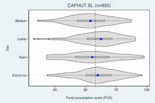
iii

Contents

List of acronyms                                                            v

Executive summary                                                          vi

1   Introduction                                                            1

2 Brief history of how the specific sentinel landscape was built and
  how work was conducted in practice (different steps, processes)           3
  2.1 Site selection                                                        4
  2.2 Description and collection of data                                    7

3 Review of other projects co- located or linked to CAFHUT                 11
  3.1 Summary of projects based on themes characterizing major development
       challenges in the landscape                                         11

4 Socioeconomic characteristics of households sampled in CAFHUT            23
  4.1 Household demographics                                               23
  4.2 Farm characteristics                                                 24
  4.3 Farm dependency and income diversity                                 25
  4.4 Household welfare, food security and nutrition                       27
  4.5 Partners involved and inventory of how stakeholders have worked in
      the landscape                                                        28

5 Lessons learned and major challenges from the projects executed in
  the landscape                                                            30
  5.1 Lessons learned                                                      30
  5.2 Challenges                                                           32
  5.3 Recommendations from projects                                        33

References list                                                            35

Annexes                                                                    37
  A    Indicators – summary statistics tables                              37
  B    Publications, projects and locations in the Cameroon SL             45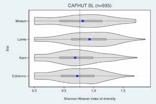
iv
List of figures and tables
Figures
1. Sentinel sites identified in the Central Africa Humid Tropics Transect 4
2. Position of the four sites along the forest transition curve 5
3. Household size 23
4. Off-farm labor demand 24
5. Age dependency ratio 24
6. Farm size distribution 24
7. Area under cultivation 24
8. Trees on farms 25
9. Tropical livestock unit (TLU) 25
10. Household domestic asset index 25
11. Contribution of farm activities to household income 26
12. Contribution of non-farm activities to household income 26
13. Contribution of forest amenities to household income 26
14. Household income composition 27
15. The Shannon-Weaver index of diversity 27
16. Livelihood resources index/wealth index 28
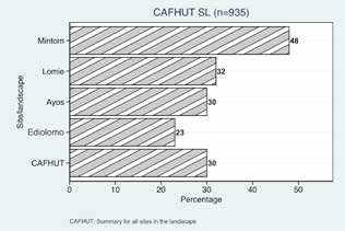
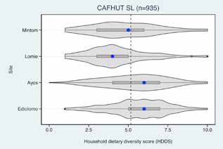
17. The Household Dietary Diversity Score (HDDS) 28
18. Food Consumption Score (FCS) 28
Tables
1. Villages selected and number of household surveys per site 8
2. Summaries of sampling plots, soil samples and infiltration rates 10
3. Deforestation-related projects 12
4. Cocoa-related projects 13
5. Projects related to poverty reduction 14
6. Summary statistics of sampled households by sentinel site 23
7. Household farm dependency and income diversity 26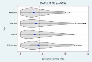
v

List of acronyms

ADNG        Association communautaire pour le développement de Ngoume
ADR         Age Dependency Ratio
AFS         Cocoa agroforestry systems
AFS4FOOD    Agroforestry for Food Security
AFTPs       Agroforestry Tree Products
AGC         Aboveground Carbon
ASB         Alternatives to Slash-and-Burn
CAFHUT      Central African Humid Tropics
CFEs        Community Forest Enterprises
CIFOR       Center for International Forestry Research
CIRAD       French Agricultural Research Centre for International Development
CODEM       Communauté de développement du village Messok-Messok
CoForSet    Congo Basin Forests – Biodiversity Offsetting Mechanisms
CoForTips   Congo Basin Forests – Tipping Points for Biodiversity Conservation
            and Resilience of Forested Socioecological Systems
CGIAR       Consortium of International Agricultural Research Centers
DRYAD       Financing sustainable community forest enterprises in Cameroon
EPHTA       Ecoregional Programme for the Humid and Subhumid Tropics of
            Subsaharan Africa.
F-cAFS      Forest-derived cocoa agroforestry systems
FCS         Food Consumption Score
FTA         Forests, Trees and Agroforestry
GDP         Gross Domestic Product
HDDS        Household Dietary Diversity Score
HFIAS       Household Food Insecurity Access Scale
ICRAF       World Agroforestry
IFRI        International Forestry Resources and Institutions
IRD         French National Research Institute for Sustainable Development
IUCN        International Union for Conservation of Nature
LDSF        Land Degradation Surveillance Framework
MIR         Mid-infrared
NTFPs       Non-Timber Forest Products
ProCISA     Pro-Intense Africa Project
REALU       Reducing Emissions from All Land Uses
REDD+       Reducing Emissions from Deforestation and forest Degradation
SAFSE       Search for trade-offs between production and other ecosystem services
            provided by tropical agroforestry systems
S-cAFS      Savanna-derived cocoa agroforestry systems
SDI         Soil Degradation Index
SL          Sentinel Landscapes
SLOs        System level outcomes
SOC         Soil organic carbon
SoCa        Beyond climate, Soil Carbon sequestration to sustain tropical family farming
STRADIV     System approach for the transition to biodiversified agrosystems
TLU         Tropical Livestock Unit
WWF         World Wide Fund for Nature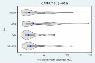
vi

     Executive summary

     The Sentinel Landscapes (SL) initiative is         area composed of degraded mature forests,
     comprised of geographic areas or sets of           where concession, community forestry and
     areas with a broad range of biophysical, social,   timber exploitation are influencing the forest
     economic and political conditions. This report     structure; (c) Ayos – situated 123 km from
     takes stock of the work carried out on the         Yaoundé, the capital of Cameroon. Ayos
     Central Africa Humid Tropics Transect Sentinel     vegetation is characterized by gallery forests
     Landscape (CAFHUT) within the context of           surrounded by swamp forests of raffia; and
     the CGIAR Research Program on Forests,             (d) Bokito – a forest-savanna or deforested
     Trees and Agroforestry (FTA). It reports on        landscape, situated some 150 km from
     core SL work and draws from the broader            Yaoundé, where secondary forest is used to
     project activities of multiple partners within     grow cash and subsistence agricultural and
     the FTA research program. The FTA research         agroforestry crops.
     consortium mainly consisted of Bioversity
     International, the Center for International        The CAFHUT core work concentrated on land
     Forestry Research (CIFOR), the French              and soil analysis as well as socioeconomic
     Agricultural Research Centre for International     analysis and mapping. The study of
     Development (CIRAD) and World Agroforestry         land health used the Land Degradation
     (ICRAF), collaborating with the French             Surveillance Framework (LDSF) as the
     National Research Institute for Sustainable.       principal field-data collection tool in the four
     The CAFHUT study sought to address the             selected sites. A total of 640 plots, 1280 soil
     following: to better understand the drivers        samples and 96 infiltrations were used for
     behind deforestation/forest degradation; to        analysis. All the collected samples were
     create the capacity and best methods to meet       processed and subsamples were shipped to
     development needs; to gauge the ecological         the Soil-Plant Spectral Diagnostics Laboratory
     and genetic impact on forests from land-cover      at ICRAF in Nairobi, Kenya. Soil samples were
     and land-use changes; and to support the           analyzed using mid-infrared (MIR) methods.
     promotion and implementation of sustainable        Socioeconomic information was collected
     multiple-use forest models as a result of          through primary and secondary sources.
     these efforts.                                     Primary data were collected in all four sites
                                                        covering 38 villages and 927 households,
     The sentinel landscape covers sites where          while secondary data were based on analysis
     the pressures of urban development,                of theses, dissertations and scientific articles.
     population growth, forest commercialization        Within the socioeconomic work, some
     and land-use transition are changing the           institutional and natural resource governance
     forest landscape at a rapid pace. Four study       activities were carried out. The detailed
     sites in Cameroon were chosen: (a) Mintom          institutional mapping exercise that was to be
     – a transition zone between mature old             implemented using the International Forestry
     growth forest and logged-over forest, with a       Resources and Institutions (IFRI) protocols
     mixture of active forest concessions, recently     – Forms A, R, F and S – and the Natural
     allocated community forests and unallocated        Resources Governance Framework never
     forest concessions; (b) Lomie-Kongo – an           took place due to a lack of resources.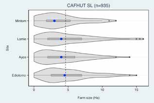
vii

In broader terms, three main areas of work         farmers and market-based agriculture;
can be highlighted with the following aims: to     conversion for commercial plantations (oil
reduce deforestation and forest degradation;       palm, banana, rubber, pineapple); mining;
to improve cocoa agroforestry and cocoa            infrastructure development; and all types
landscapes; and to alleviate poverty. These        of logging schemes (industrial, artisanal,
are the key land-management issues in the          legal and illegal) are the principal drivers
CAFHUT landscapes. Following a review              of deforestation. There remain challenges
of projects and research in these three            relating to technology in mapping land-use
areas over the past 10 years, we provide an        changes and to legal definitions of forest. For
overview of the work carried out.                  emission-reduction strategies to be efficient,
                                                   cross-sector collaboration by all stakeholders
Reducing deforestation and forest                  is required. For instance stakeholders in the
degradation: With an increasing human              cocoa sector, intensifying cocoa agroforestry
population and demand for food, pressure           systems have the potential to store about 180
on the forest has increased along the              tons of carbon per hectare; a reason enough
sentinel landscape. Three projects aimed to        to promote agroforestry, especially if coupled
reduce emissions from all land use, to exploit     with tree planting on farms for timber and
opportunities for avoided deforestation with       food.
sustainable benefits, and to identify points for
biodiversity conservation and the resilience       Cocoa agroforestry systems and landscapes
of forested social and ecological systems.         improvement: Just like in any forest area
With the help of satellite images, it was          within the Congo Basin, cocoa agroforestry
predicted that deforested areas in Mindourou       is one of the dominant land uses along
and Guéfigué will increase twofold over the        the sentinel landscape, contributing to the
period 2020–2030 compared with the period          livelihoods of millions of farmers. Cocoa is
2000–2010. The results equally highlight that      the main farming activity, representing 89%
cassava, groundnuts and maize are the main         of cultivated areas and 59% of agricultural
crops responsible for cropland expansion,          income for households in the village of
while the area dedicated to the cultivation        Talba. Project interventions along this
of palm oil is also expected to double from        landscape aimed to resolve problems
2010 to 2030. Land-cover maps for Akok and         relating to diversification and intensification;
Awae show different patterns of land-use           soil characteristics; cocoa yield; botanical
evolution between the two villages. Forest         composition and vegetation structure; pests
land in Akok decreased from 26% to 18%,            and diseases as well as contribution to
while secondary forest increased from 57% to       household income. A total of six projects
67%. Awae experienced a reduction of forest        developed various interventions aimed at
land from 14% to 7%, while secondary forest        improving cocoa agroforestry in terms of yield
remained relatively stable; however, short-        and farmer incomes, while reducing forest
duration fallow increased from 22% to 34%. A       clearance for agriculture. For example, results
feasibility assessment of emissions reductions     revealed that a total of 6677 cocoa plants
in Efoulan municipality was conducted from         were produced in Lobeke and the plants
2001 to 2007, showing a considerable decline       from the communities’ nurseries were used
in undisturbed forest, amounting to 194 ha/        to establish small cocoa plots of 2.5 ha. In
year mainly due to cocoa plantations (145 ha/      2015, a total of 2760 trees were integrated
year) and crop fields (45 ha/year). Logged         into cocoa agroforestry systems in Efoulan,
forests decreased by 63 ha/year due to land        while 85% of cocoa farmers in this area
degradation, thus weakening the landscape’s        were engaged in the intensification of cocoa
carbon stock potential.                            agroforestry systems through tree planting.
                                                   An evaluation of potential yield in Bokito
An analysis shows that various drivers are         showed that the average number of pods per
responsible for the deforestation and land         tree is 17.3 and the average weight of pods
degradation of the CAFHUT landscape.               is 497.4 g (0.497 kg). In Bokito, the average
Land conversion by small-scale subsistence         density of cocoa population is 1222 plants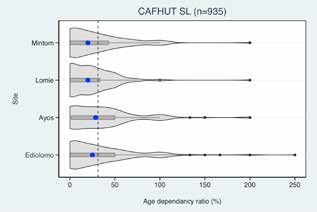
viii

       per hectare and yields increase significantly                 (especially for njansang, Irvingia and Gnetum)
       with age. On average, irrespective of                         without any germplasm improvement and/
       age, potential yields were higher on plots                    or management. From such projects, it
       created on savanna-preceding (866.9 kg/                       became evident that for farmers to reap the
       ha) than those created on forest-preceding                    full benefits and increased revenue from
       vegetation (786.6 kg/ha), but the yields                      most NTFPs more attention was needed to
       were not significantly different. Diseases are                conservation, processing and packaging
       responsible for 17% of losses, while 2% is lost               issues. In this regard, experience from such
       to rodents. It is observed that the destruction               projects suggests that more development
       caused by mirids1 increases with the age of                   projects are needed on value chains to
       the farm.                                                     explore processing opportunities. However,
                                                                     this would require teaming up with more
       Although interventions along this landscape                   specialized institutions and, if possible, the
       aimed at improving the quality and quantity                   private sector.
       of cocoa while boosting farmers’ incomes,
       pest management remains a major problem                       Some projects tested organizational
       for farmers. Issues relating to post-harvest                  arrangements by which NTFP producers can
       management and the entrepreneurial                            link up more efficiently with traders and the
       aspects of cocoa agroforestry were not                        private sector. The ultimate objective was
       sufficiently examined by the various                          to improve the integration of low-income
       projects. Thus, for farmers to fully benefit                  farmers in NTFP value chains. Results show
       from cocoa agroforestry systems, using a                      that it is important to increase the capacity
       holistic approach that includes the business                  of producers and traders, so that they can
       dimension will provide additional motivation                  engage in collective action and connect
       for farmers to take up new concepts as                        with each other. It is also vital to develop
       significant employment and income will be                     financial mechanisms in order to overcome
       generated.                                                    some of the barriers that producers and
                                                                     traders face when they try to increase their
       Poverty reduction: Although a major goal                      participation in value chains. Some of the
       of most project interventions in the SL is                    projects concluded that much work still
       to address poverty, some were specifically                    needs to be done to develop NTFP markets
       designed to diversify and stabilize the                       and products. It is also necessary to help
       incomes of poor small-scale farmers by                        farmers and traders to develop sustainable
       increasing their participation in – and benefits              enterprises around NTFPs.
       from – the value chains of agroforestry
       tree products (AFTPs). From a value chain                     Results from the projects show positive
       perspective, we learned from projects                         effects of collective action on farmer
       carried out in the landscape that vegetative                  livelihoods. However, some of the research
       propagation and on-farm cultivation of non-                   also raised questions that would need more
       timber forest products (NTFPs) can effectively                in-depth social and anthropological research
       contribute to sustained quality production and                in order to fully understand producers’
       therefore, play an important role in improving                behavior and to facilitate the scaling of the
       value chains. However, many producers still                   approach beyond project sites.
       collect trees/vines that grow spontaneously

       1   The term mirid or miridae refers to a large and diverse
           insect family also known by the taxonomic synonym
           Capsidae. Common names include plant bugs, leaf
           bugs, and grass bugs. See also: http://research.amnh.
           org/pbi/
1 Introduction
The Sentinel Landscapes (SL) initiative is limited funding, field research in CAFHUT was
comprised of geographic areas or sets of limited to two areas: (a) land and soil analysis,
areas with a broad range of biophysical, and (b) socioeconomic analysis and mapping.
social, economic and political conditions. The study of land health used the Land
It is part of the CGIAR Research Program Degradation Surveillance Framework (LDSF)
on Forests, Trees and Agroforestry (FTA), as the principal field-data collection tool in
which was established in 2011 to conduct the four selected sites. A total of 640 plots,
long-term research, using standardized 1280 soil samples and 96 infiltrations were
methodologies, on the temporal and spatial used for analysis. All the collected samples
dynamics of trees and forests in selected were processed and subsamples were
sites. The Central African Humid Tropics shipped to the Soil-Plant Spectral Diagnostics
(CAFHUT) sentinel landscape covers sites Laboratory at the World Agroforestry
where the pressures of urban development, (ICRAF) in Nairobi, Kenya. Soil samples were
population growth, forest commercialization analyzed using mid-infrared (MIR) methods.
and land-use transition are changing the Socioeconomic information was collected
forest landscape at a rapid pace. Four study through primary and secondary sources.
sites in Cameroon were chosen: (a) Mintom Primary data were collected in all four sites
– a transition zone between mature old covering 38 villages and 927 households,
growth forest and logged-over forest, with a while secondary data were based on analysis
mixture of active forest concessions, recently of theses, dissertations and scientific articles.
allocated community forests and unallocated Within the socioeconomic work, some
forest concessions; (b) Lomie-Kongo – an institutional and natural resource governance
area composed of degraded mature forests, activities were carried out. The detailed
where concession and community forestry institutional mapping exercise that was to be
and timber exploitation are influencing the implemented using the International Forestry
forest structure; (c) Ayos – situated 123 km Resources and Institutions (IFRI) protocols
from Yaoundé, the capital of Cameroon. Ayos – Forms A, R, F and S – and the Natural
vegetation is characterized by gallery forests Resources Governance Framework never
surrounded by swamp forests of raffia; and took place due to lack of resources.
(d) Bokito – a forest-savanna or deforested
landscape, where secondary forest is used This report takes stock of the work carried
to grow cash and subsistence crops by out in the CAFHUT Sentinel Landscape within
agricultural and agroforestry means. the context of the CGIAR Research Program
on Forests, Trees and Agroforestry. It reports
The CAFHUT project aimed to collect on core SL work and draws from the broader
socioeconomic, institutional and biophysical project activities of multiple partners within
information to assess the relationship the FTA research program. The FTA research
between livelihoods and land health in consortium mainly consisted of Bioversity
forested landscapes that have been exposed International, the Center for International
to various forms of land-use change. Due to Forestry Research (CIFOR), the FrenchDenis J. Sonwa, Frederick N. Numbisi, Duplex Noumbissi, François E. Manga, Patrice Levang, Bertin Takoutsing, Albert LG. Fosso, Laurent Vidal,
2 | Brian Chiputwa, D. Foundjem-Tita, Frankline Nghobuoche, Serge M. Piabuo and Peter A. Minang
Agricultural Research Centre for International over the past 10 years. The section is
Development (CIRAD) and World divided into two subsections: Subsection
Agroforestry (ICRAF). The CAFHUT study 2.1 summarizes the findings under three
sought to address the following: to better themes characterizing major development
understand the drivers behind deforestation/ challenges/opportunities in the landscape,
forest degradation; to develop the capacity including deforestation; cocoa intensification
and best methods to meet development and diversification; and poverty reduction.
needs; to gauge the ecological and genetic Subsection 2.2 links the various research
impact on forests from land-cover and land- projects to the four themes planned in
use change; and to support the promotion 2012, including socioeconomic, institutional,
and implementation of sustainable multiple- biophysical and land health. Section 3
use forest models as a result of these efforts. covers a preliminary analysis of the
socioeconomic data collected within the
The rest of the report is structured as CAFHUT. The results are divided into
follows: Section 1 explains how the sites household assets and ownership, household
were selected and provides an overview farm dependency, income diversity, poverty,
of the four sites that were finally retained. as well as household welfare, food security
A description of the socioeconomic and and nutrition. Section 4 highlights the
biophysical data on land degradation is partners involved and makes an inventory
presented in this section, together with the of different stakeholders who have worked
sampling plans for both studies. Section in the landscape. Section 5 underscores the
2 is a systematic analysis of research lessons learned, as well as major challenges
activities that different development and recommendations from projects
partners have conducted in the landscape executed within the landscape.2 Brief history of how the specific
sentinel landscape was built
and how work was conducted
in practice (different steps,
processes)
The Sentinel Landscapes project is the to low deforestation in the past are changing
result of consultations that took place in the and will continue to do so with globalization.
CAFHUT region during the development (and/ Therefore, based on their experience in
or the early implementation phase) of FTA. It the Congo Basin and with the help of their
also relies on the willingness of participants regional/worldwide networks, the CAFHUT
to provide a set of transects for medium- to research centers collaborated to address the
long-term research that can inform decision following: (i) to better understand the drivers
makers. The region has hosted benchmark behind deforestation/forest degradation; (ii)
studies through the Alternatives to Slash-and- to create the capacity and best methods to
Burn (ASB) program and EPHTA (Ecoregional meet development needs; (iii) to gauge the
Programme for the Humid and Subhumid ecological and genetic impact on forests from
Tropics of Subsaharan Africa), providing a set land-cover and land-use changes; and (iv) to
of transects that represented the Congo Basin support the promotion and implementation of
and the humid forest zone of West and Central sustainable multiple-use forest models.
Africa, respectively. The overarching idea
behind the SL was to utilize the multidisciplinary Sites were selected based on their
and diverse experience of the institutions in representativeness of the humid forest
order to generate information that can open up landscapes in Central Africa, while taking
transformational pathways. This should be done advantage of some existing activities within
while making reference to the System Level the sites. The CAFHUT represents a dynamic
Outcomes (SLO) of CGIAR, including (i) to reduce socioecological gradient of forest and land
poverty; (ii) to improve health, food security and use in the Congo Basin. Currently focused
nutrition; and (iii) to enhance environmental on Cameroon, the project chose sites that
sustainability and ecosystem services. The idea demonstrate a gradient where forest and
was therefore to have new sites, and then to tree-based livelihoods are – and will be –
conduct a baseline assessment of the status prevalent means of poverty alleviation. These
quo along the SL. sites are also affected by the pressures of
urban development, population growth, the
The Congo Basin is considered a barometer commercialization of forest products and land-
of ecological and socioeconomic conditions use transition. These factors are changing the
in forest landscapes on the African forest landscape at a rapid pace. In particular,
continent. Since the Congo Basin provides the landscape features are:
several ecological services (i.e. biodiversity 1. Mature humid dense forest in the
conservation and climate-change mitigation) and southeast of the country, where forest-
products, the threats to its environmental health dwelling men and women profit from
are an issue for the international community. hunting as well as the consumption and
Unfortunately, some factors that contributed sale of non-timber forest products.Denis J. Sonwa, Frederick N. Numbisi, Duplex Noumbissi, François E. Manga, Patrice Levang, Bertin Takoutsing, Albert LG. Fosso, Laurent Vidal,
4 | Brian Chiputwa, D. Foundjem-Tita, Frankline Nghobuoche, Serge M. Piabuo and Peter A. Minang
2. Fragmented mosaics of primary and 2.1 Site selection
secondary forests impacted by (a) an
extensive yet poorly understood informal The CAFHUT site was selected by a
timber market, (b) a 100-year-old logging consortium of Bioversity International,
industry that accounts for 6 percent (on CIFOR, ICRAF and CIRAD. This followed
average) of the gross domestic product two larger workshops in 2012, designed
(GDP) of many Central African countries, to identify partners and sites within which
and (c) vast roads paving the way to the work would be done. The selection
logging and mining concessions in the process downsized from 15–10 sites of
heart of the Congo Basin. 10 x 10 km2 to a shortlist of eight sites that
3. Peri-urban areas where both primary and were later visited by a team of researchers
secondary forest fragments still exist, but from Bioversity International, CIFOR and
where the land use has been dominated ICRAF. Four sites – Bokito, Ayos, Mintom
by mixed smallholder agroforestry and and Lomie/Kongo – were finally chosen
intensified agricultural systems. by a committee after field visits (Figure 1).
4. Zones where forest meets savanna and The sites discarded were Bafia, Obala and
agricultural activities dominate, but where Bikok and the site in the Dja reserve was
local inhabitants have begun to reap the indicated as a nonactive research site that
rewards of cocoa agroforestry, slowly should represent the ‘mature growth forest.’
transforming deforested landscapes into The four sentinel sites thus represented a
productive and profitable tree-based gradient of intensive agriculture, pasture,
livelihoods (Figure 1). agroforests and forests.
Figure 1. Sentinel sites identified in the Central Africa Humid Tropics Transect
Source: Cameroon sentinel landscape team, Data: WRI Interactive forestry atlas of Cameroon 2013
Note: SL sites indicated in red rectangles.Central Africa Humid Tropics Transect Sentinel Landscape (CAFHUT) | 5
2.1.1 Brief presentation of the four Lomie-Kongo: Located in the Upper Nyong
selected sites and key research questions division of Cameroon’s Eastern Province
between latitude 03˚09’ N and longitude
Figure 2 below presents the position of each 013˚37’ E with an altitude of 624 m. It is
site along the forest transition curve. characterized by a wet equatorial climate
(also known as a Guinea-type climate) and
Mintom: Located in southern Cameroon high temperatures (24˚C on average). There
between latitude 2˚30’ and 2˚45’ N and is a long dry season from December to May,
longitude 13˚15’ and 13˚30’ E, within a humid a light wet season from May to June, a short
equatorial climatic zone. The southern part of dry season from July to October, and a heavy
Cameroon is a vast area stretching from the wet season from October to November.
Atlantic Coast in the West to the Congo Basin Humidity and cloud cover are relatively
in the east. This area features plateaus with high, and annual precipitation averages
a lower altitude of 620m and is inhabited by 1500–2000 mm. Lomie-Kongo is sparsely
more than 10,000 people across 60 villages. populated with fewer than five persons per
Most belong to the Fang, Djem, Nzimé, and km². This is mostly due to the area’s thick
Baka ethnic groups. The Ngoyla-Mintom forests, which inhibit settlement and support
forest block is found in this region and covers disease-carrying insects. The vast majority
932,142 hectares – the largest expanse of of the region’s inhabitants are subsistence
undisturbed tropical rainforest in Cameroon. farmers. Major crops are plantains, maize,
In this landscape, this site represents the groundnuts, cocoyams, cassava, pineapples,
transition between mature old-growth forest oranges, mangoes and yams. The dense
and logged-over forest, with a mixture of forest and the presence of the tsetse fly
active forest concessions, recently allocated prevent much cattle raising, but various
community forests, and unallocated forest livestock are raised for subsistence purposes.
concessions. Currently, the site hosts both Lomie-Kongo represents degraded mature
production and virgin primary forest as well as forest, where concession and community
an important wildlife corridor, but a vast road forestry and timber exploitation are some of
is being opened through this area, meaning the principal activities influencing the area’s
that radical changes have been observed forest structure. Other forest-related activities
in a period of just a few years. Markets have include hunting and the collection of some
opened and smallholder/community activities non-timber forest products. Agriculture and
have intensified, including agriculture and agroforestry practices exist, but they have not
agroforestry, hunting, informal logging, and been intensified because access to markets
commercial activities. is more difficult here.
Mintom Lomie/Kongo Ayos Bokito
Degradation
Reforestation and
Agroforestation
ecosystems services
Forest and trees
Deforestation
Old growth Logged-over Secondary and Annual Grassland Mosaic landscape with
forest forest agroforest crops agroforestry, plantations,
crop fields, woodlots
Figure 2. Position of the four sites along the forest transition curveDenis J. Sonwa, Frederick N. Numbisi, Duplex Noumbissi, François E. Manga, Patrice Levang, Bertin Takoutsing, Albert LG. Fosso, Laurent Vidal,
6 | Brian Chiputwa, D. Foundjem-Tita, Frankline Nghobuoche, Serge M. Piabuo and Peter A. Minang
Ayos: The municipality of Ayos is situated network of peatlands - the Ayos-Abong-Mbang
123 km from Yaoundé, the capital of peatlands (Bernard et al. 2013). This is said to be
Cameroon. Ayos vegetation is characterized a perculiar ecological milieu, especially in terms
by gallery forests surrounded by swamp of biodiversity and carbon storage in terrestrial
forests of raffia and cocoa-production peatlands. The presence of ICRAF, through
systems of much lower intensity. Ayos has a ASB research experience, is an assurance for
surface area of 1250 km2 with an estimated available information about the dynamics in the
population of 22,899 inhabitants. The entire area.
population of this municipality depends
directly on subsistence farming for their Bokito: Located between 4°35’ N and 11°8’ E
livelihoods, with cocoa among the main in the Center Province of Cameroon in the
agricultural produce. The zone falls within the Mbam-et-Inoubou district. It consists of more
forest margin landscape where agriculture than 10 villages: Assala, Bakoa, Begny, Bokaga,
and agroforestry products are the mainstay Bongando, Okolé, Kedia, Ossimb I, Ossimb II,
for much of the population, and agricultural Tchekos, Yorro, Tobagne and Omeng. The
practices are relatively mature (mostly cocoa, Yambassa is the primary ethnic group. Other
coffee, oil palm). The area is inhabited by groups include Lemandé (Tchekos) and
growing rural communities with access to Mma’ala (Omende,Yangben). Bokito has an
markets and comprises about 39 villages equatorial transition-type climate with bimodal
under two main groups – Yebekolo-Est and rainfall, characterized by two rainy seasons
Omvang. Its geographical position provides and two dry seasons with variable durations.
an avenue for the flow of money, which is The average temperature is 26.8°C and the
reflected by progressive investments in average annual rainfall is between 1200mm and
activities such as fishing, hunting and small- 1450mm. The main dry season lasts 5 months
scale plantations (cocoa, oil palm, pineapple), (mid-November to mid-April). Bokito is located
supplying local and neighboring markets in in the forest-savanna transition zone, where
Abong Mbang to the east and from Awae to there is a low population density (29 inhabitants
Yaoundé in the west. per km2), characterized by a patchwork of forest
galleries along with herbaceous and sedge
There is a high presence of elite population savannas on rejuvenated, slightly desaturated
and investments in the area, and a well- soils. Cultivation of cocoa is exclusively carried
established road network that has provided out by the autochthones of the Yambassa ethnic
access to large markets. The site is inhabited group. Bokito represents the forest-savanna or
by growing rural communities with access deforested landscape dynamic, where secondary
to markets and comprises about 39 villages forest is used for growing cash and subsistence
under two mains ethnic groups – Yebekolo agricultural and agroforestry crops. All forest land
and Omvang. Its geographical position has been allocated, so some farmers have begun
provides avenue for economic activities as to successfully grow cocoa and oil palm in the
is reflected in the progressive investments savanna. The site shows deforested landscapes,
in activities such as fishing, hunting, small forest-savanna mosaics and successful
scale plantations (cocoa, oil palm, pineapple, reforestation efforts. There is good access by
etc.), which supply local and neighbouring road, and a long-term CIRAD presence, ensuring
markets in Abong Mbang to the East and links to local smallholders and some past data.
from Awae towards Yaoundé in the West. Its
vegetation is characterised by gallery forests The four sites in southern Cameroon were
surrounded by swamp forests of raffia. Most selected because they represented different
municipalities depend directly on subsistence stages of the forest transition curve. This project
farming for their livelihoods with cocoa being aimed to collect a set of standardized variables,
one of the principal agricultural produce. both socioeconomic and biophysical, in order
Thus, agriculture and agroforestry products to assess the relationship between livelihoods
are the mainstay for a large proportion of and land health in forested landscapes that
the population, and agricultural practices have been exposed to various forms of land-
are relatively mature (mostly cocoa, coffee, use change. The data will be used to conduct
oil palm). The swamp forests of the upper a comparative study on the following research
part of Nyong river tributaries form a sort questions:Central Africa Humid Tropics Transect Sentinel Landscape (CAFHUT) | 7
• What are the institutional settings that favor respondents. Ultimately, 38 villages were
the utilization of forest resources in ways chosen and 927 households were surveyed
that result in more equitable sharing of (Table 1).
benefits?
• What are the factors that induce people to Research design and tools
value the ecosystem services of trees and to
manage the landscape for this purpose? Data source and tools used for collection
• What are the conditions that allow farmers to Two sources of information were used in this
significantly capitalize on tree products and study: primary and secondary.
to benefit from them?
Secondary sources
Secondary sources helped us to obtain and
2.2 Description and collection mobilize existing data through documentary
of data analysis (theses, dissertations, research
articles) available in CIFOR’s library, online and
2.2.1 Socioeconomic at the stakeholder level.
Village selection and household surveys Primary sources
Primary sources permitted us to gather new
Village selection data sets. This data collection was carried
For the socioeconomic study, the selection of out through focus group discussions and
villages for each sentinel site was based on: household surveys.
• accessibility of the villages (cost of logistics);
• total number of villages within and around Focus group discussions
the sentinel site; Focus groups helped us to collect information
• total population within and around the at the village level. This included data on:
sentinel site. • demographics
• formal and informal institutions
Whenever possible, a minimum of 10 villages • use, access, governance and management
were randomly selected for each sentinel site. of trees and tree products
• access to markets and structure of
Villages were located within a 30 x 30 km2 the markets
radius based on the center of the LDSF site. • collective action
A minimum of five villages were chosen within • social mobility within the village
the core sentinel site (10 x 10 km2) to ensure
that we have a collocation of both biophysical The following IFRI instruments2 were used in
and socioeconomic samples. focus group discussions:
a. Form F: The Forest Form defines a forest
Villages were stratified based on: as a surface area of at least 0.5 ha that
• distance to main road (distance from market) has woody vegetation, is exploited by at
• ethnic groups (migratory vs. resident least three households, and is governed
villages) overall by the same legal structure. This
• distance from forest edge form was aimed at collecting data on the
forest area’s size, ownership, vegetation,
Household surveys forest products harvested, and their uses.
For the household surveys, a representative Changes in the density of trees, grassland
sample was randomly selected from each or ground cover, as well as changes in
of the villages taking part in the survey. forest area, were also captured.3
This sample covered about 25–30% of all
households. To randomize samples, we used
2 For an extensive review of the IFRI methodology and
a list of households from the national census. instruments, refer to the IFRI manual here: http://ifri.
Acknowledging that men and women have forgov.org/wp-content/uploads/2012/09/IFRI_Manual.
different roles and viewpoints in a household pdf
and in the community, we tried to ensure 3 http://www1.cifor.org/fileadmin/subsites/sentinel-
an equal representation of female and male landscapes/document/Forest_Form.pdfDenis J. Sonwa, Frederick N. Numbisi, Duplex Noumbissi, François E. Manga, Patrice Levang, Bertin Takoutsing, Albert LG. Fosso, Laurent Vidal,
8 | Brian Chiputwa, D. Foundjem-Tita, Frankline Nghobuoche, Serge M. Piabuo and Peter A. Minang
Table 1. Villages selected and number of household surveys per site
Villages Households
Site Number of villages Number of households
Name Total
per site per site
Abeng-Nnam 29
Bifos 24
Mbang 29
Mekouma 11
Ndelle 34
Ayos 10 271
Ngoumesseng 33
Niamvoudou 33
Nkolmveng 15
Nsan_II 28
Yebe 35
Bakoa 33
Batanga 31
Bongando 30
Bougnoungoulouk 29
Kedia 30
Bokito 10 323
Ossimb 33
Tchekos 35
Tobagne 30
Yangben 39
Yoro 33
Achip_2 17
Doumzok_2 10
Eschiambor 33
Kongo 32
Lomie-Kongo 9 Mayang 27 199
Melene 9
Moanguele_Bosquet 29
Nemeyong_III 9
Ngola 33
Akom 30
Assok 7
Belle-ville 4
Bite 6
Mintom 9 Ekombite 20 134
Lele 28
Mboutoukong 16
Nkolfong 15
Nkolkoumou 8
Total 38 927
b. Form S: The Settlement Form identifies soil types, vegetation, topography
a settlement inhabited by one or more and elevation of the settlement and
communities and elicits demographic surrounding area.4
information about the settlement and
its relation to external markets and
administrative centers. The form also 4 http://www1.cifor.org/fileadmin/subsites/sentinel-
collects information on climatic features, landscapes/document/SL_Settlement_Form.pdfCentral Africa Humid Tropics Transect Sentinel Landscape (CAFHUT) | 9
c. Form A: The Forest Association Form is hierarchical sampling design (Vågen et al.
designed to obtain information relating to 2013; Vågen et al. 2016). The framework
one or more forests through the activities is useful in monitoring changes over time
of forest users.5 and providing opportunities for targeting
d. Form R: The Forest Product Form improved soil management and land
collects data on consumptive and non- restoration activities (Winowiecki et al. 2018).
consumptive uses of forest products by a
households in a settlement.6 Field data collection
Household surveys Observations and measurements were
The Sentinel Landscape Household Module7 made at the plot (1000 m2 circular plots) and
was used to collect information at the subplot levels (100 m2 circular plots) following
household level. procedures described in Winowiecki et al.
(2018). The following data were recorded at
2.2.2 Biophysical assessment and Land each plot (n = 160 per site): observations of
Degradation Surveillance Framework slope (in degrees); vegetation structure using
(LDSF) the FAO Land Cover Classification System
(forest, woodland, bushland, shrubland,
Experimental design wooded grassland, grassland, or cropland);
topographic position (upland, ridge/crest,
Four sentinel sites that are statistically mid-slope, foot-slope or valley); land
representative of the variability in climate, management; and land-use history.
topography and vegetation of the sentinel
landscape area were established, as shown Visible observations and classification of
in Figure 1. The sites were characterized soil erosion prevalence were made within
using the LDSF as the field data collection each circular subplot (n = 4 per plot, 640 per
tool. The LDSF is a spatially stratified, random site), such as gully erosion, rill erosion, sheet
sampling design framework built around the erosion or none. Vegetation was measured at
concept of sentinel site (Vågen et al. 2010; the subplot level, and woody and herbaceous
Vågen et al. 2013; Winowiecki et al. 2016). covers were rated as: 65%. All trees (height >3 m)
of 100 km2 that is representative of a larger and shrubs (1.5–3 m) within each subplot
area of landscape. Each sentinel site was were counted in order to obtain stem density
further subdivided into 16 grids of 2.5 x estimates.
2.5 km within which 10 sampling plots were
randomly allocated, resulting in 160 plots per Composite soil samples were collected
site. Each plot has an area of 1000 m2 and at each plot using soil augers, combining
consists of four subplots of 100 m2 each. The topsoil (0–20 cm) samples from each of
coordinates of the plots were loaded onto a the four subplots into one sample, and the
handheld Global Positioning System (GPS), four subsoil (20–50 cm) samples into one
which was used to navigate to each of the subsoil sample per plot, giving a total of
160 sample plots that make up the site. 320 samples per site. In addition, cumulative
and undisturbed soil samples were collected
The framework allows the assessment of in four depths (0–20 cm, 20–50 cm, 50–
several ecological metrics simultaneously 80 cm and 80–110 cm), totaling 480 samples
at four different scales (100 m2, 1000 m2, per sites. All the collected samples were
1 km2, 100 km2), using a spatially stratified, processed and subsamples were shipped
to the Soil-Plant Spectral Diagnostics
5 http://www1.cifor.org/fileadmin/subsites/sentinel-
Laboratory of ICRAF in Nairobi, Kenya.
landscapes/document/Association_Form_A.pdf Collected soil samples will be analyzed using
6 http://www1.cifor.org/fileadmin/subsites/sentinel- the mid-infrared (MIR) reflectance according
landscapes/document/SL_Product_Form_R.pdf to procedures described in Terhoeven-
7 http://www1.cifor.org/fileadmin/subsites/sentinel- Urselmans et al. (2010). Regression analysis
landscapes/document/SL_Household_Module.pdf will use MIR data as independent variables,Denis J. Sonwa, Frederick N. Numbisi, Duplex Noumbissi, François E. Manga, Patrice Levang, Bertin Takoutsing, Albert LG. Fosso, Laurent Vidal,
10 | Brian Chiputwa, D. Foundjem-Tita, Frankline Nghobuoche, Serge M. Piabuo and Peter A. Minang
Table 2. Summaries of sampling plots, soil samples and infiltration rates
Sentinel site Number of Standard soil Cumulative soil Number of
sampling plots samples samples infiltrations
Ediolomo (Bokito) 160 320 420 48
Ayos 160 320 420 48
Kongo (Lomie) 160 320 420 0
Meyiboto (Mintom) 160 320 420 0
Total 640 1280 1680 96
and the laboratory data from 10% of the Bokito site: The team worked in the following
samples as dependent variables. Infiltration villages: Tchekos, Bokaga, Ediolomo and
measurements were made in three plots Mbela. The sites were chosen based on the
within each cluster to give a total of presence of a health center since we needed
48 infiltration per site. to present the epidemiological profile of
each site. We also took into consideration a
All the landscape information was assessed difference in the vegetation and the proximity
with the help of a Global Positioning System of the forest. The accessibility of the villages
(GPS-Trimble Juno 3D) in which an electronic was also taken into account given the
data-entry system built on the CyberTracker prevailing rainfall and the state of the roads.
platform was installed. The summary of soil
samples and infiltration data is in Table 2. Ayos site: The survey took place in these
four villages: Obis, Olembe, Mbang Oyebo’o
Human health and Ndelle. These villages were chosen
following the same criteria as for the Bokito
As health is one of the main SLOs of CGIAR’s site: presence of health for epidemilogical
work, we initiated a preliminary study on profile data, difference in vegetation,
this issue in our SL. Because of budget proximity of forests, and accessibility of the
constraints, we were only able to work on villages. The methodology involved the use
two of the four sites. The emphasis here of surveys, direct observations and document
was placed on the preliminary study and consultations to extract information.
the production of draft guidelines, which
may be useful for other sentinel landscapes.
Bokito and Ayos were thus retained for this
preliminary study on health.3 Review of other projects
co- located or linked to CAFHUT
The Central African Humid Tropics Sentinel challenges/opportunities that denote the
Landscape (CAFHUT) site was selected landscape, including deforestation; cocoa
through a collaborative effort of scientists intensification and diversification; and poverty
from Bioversity International, CIFOR, ICRAF reduction. See Annex A for details on projects
and CIRAD. Besides CAFHUT research, some reviewed.
partners carried out parallel activities in the
landscape. This section will systematically 3.1.1 Deforestation and land use dynamics
map out and analyze the research activities
that different research and development Several projects monitored deforestation
partners have conducted in the landscape and the carbon sequestration potential along
over the past 10 years. The report also makes different patches in the CAFHUT landscape.
a link between research activities carried The CoForTips8 project assessed the
out in the landscape and those planned vegetation in Mindourou and Guéfigué with
in 2012. Specifically, the report highlights the aim of identifying points for biodiversity
the background and purpose for different conservation and the resilience of forested
interventions by partners, describing their social and ecological systems. Over the
major development achievements as well as entire study area, satellite images (Landsat
the challenges identified in the landscape. and SPOT) were used to account for land-use
The knowledge generated is also reported dynamics. Results projected that deforested
through publications. areas will increase twofold over the period
2020–2030 compared with the period
The reported information was sourced 2000–2010 due to increasing populations
from key FTA partners, including Bioversity and higher average consumption per capita.
International, CIFOR, ICRAF and CIRAD. The results also showed that cassava,
The lead researchers from each of these groundnuts and maize are the main crops
institutions who supervised projects in the responsible for cropland expansion, and the
sentinel landscape provided the required area dedicated to palm oil cultivation will also
information. In cases where the lead double from 2010 to 2030.
researchers were not available, data were
obtained from online sources, using Google Analysis of deforestation and degradation
and consulting the websites operated by by the ASB-REALU team (see Table 3) shows
some of the projects and partners. that deforestation and forest degradation
in the CAFHUT landscape are caused by
a combination of drivers, including land
3.1 Summary of projects based conversion for small-scale subsistence
on themes characterizing major and market-based agriculture; conversion
development challenges in the for agro-industry and plantations (oil palm,
landscape
This section summarizes project findings 8 CoForTips Project: https://www.cofortips.org/en/the-
that address the three major development products/reportsDenis J. Sonwa, Frederick N. Numbisi, Duplex Noumbissi, François E. Manga, Patrice Levang, Bertin Takoutsing, Albert LG. Fosso, Laurent Vidal,
12 | Brian Chiputwa, D. Foundjem-Tita, Frankline Nghobuoche, Serge M. Piabuo and Peter A. Minang
banana, rubber); mining; infrastructure 3.1.2 Cocoa improvement, intensification
development; and all types of logging and diversification
schemes (industrial, artisanal, legal and
illegal). The research demonstrated that Several projects have been carried out in the
there are some challenges to developing Bokito site, which is characterized by forest-
an accurate understanding of how land savanna vegetation where secondary forest
cover is changing. Most of the challenges is used for growing cash and subsistence
are due to technological limits but are also agricultural and agroforestry crops. Projects
complicated by an unclear definition of what implemented in this site included STRADIV9
legally qualifies as ‘forest.’ More research (2016–2018), SoCa (2018–2020), SAFSE10
is needed to understand the spatial and (2012–2015), and Agroforestry for Food
temporal patterns and the synergies among Security (2012–2015). The objectives of these
the various drivers. projects varied, but their central themes were
to identify the effect of past land uses (forest
and savanna) on the current ecosystem
Table 3. Deforestation-related projects multi-functionality of cocoa agroforestry
systems while gaining more insights into the
No. Project Research Location sustainability of those systems. The STRADIV
institution project, for example, showed that over a
1 Reducing emissions ICRAF, IITA, Nyong period of about 80 years, there has been a
from all land uses IRAD and So’o, steady increase in both aboveground carbon
(REALU). Linking Ocean, (AGC) and soil organic carbon (SOC) after
development Mvila, and converting savanna into cocoa agroforestry
pathways Valee du systems (AFS).
and emission Ntem
reduction at local Part of the SAFSE project involved
levels: Feasibility characterizing the arboreal arthropod
assessment of
community in cocoa-based agrosystems.
emission reductions
Results from Tchoudjin (2014) in the locality of
in Efoulan
municipality in Bokito showed that a total of 16 invertebrate
Cameroon orders were identified from a set of
33,900 individuals collected on the four
2 Opportunities CIRAD Awae and prospected plots. The order Hymenoptera
for avoided Akok (with relative abundance of 93, or 10%)
deforestation with dominated, along with Formicidae. The ant
sustainable benefits
fauna reported was composed of 60 species
in central plateau
of Cameroon,
belonging to six sub-families and 21 genera,
Guinean-Congolian dominated by the Myrmicinae sub-family with
forest margins 72, or 70% abundance.
(2009-2011)
The Agroforestry for Food Security project
3 Congo Basin CIRAD Mindourou executed in Bokito and Talba explored the
Forests: Tipping and
effects of trees on soil quality conservation
Points for Guéfigué
Biodiversity
in AFS-containing food crops. The
Conservation and results showed that (a) among all the soil
Resilience of the characteristics checked, significant soil quality
Forested Social and indicators were phosphorus, C/N ratio, ferrous
Ecological Systems ion (Fe2+), silt and soil organic carbon; (b)
(CoForTips and the soil degradation index (SDI) calculated
CoForSet projects)
9 STRADIV Project: https://stradiv.cirad.fr
10 SAFSE project: https://safse.cirad.fr/en/publications/
reportsCentral Africa Humid Tropics Transect Sentinel Landscape (CAFHUT) | 13
from those soil analyses decreased with trees; and the promotion of integrated soil
AFS age; (c) soils from AFS were in a relative fertility management. The project established
state of equilibrium regardless of their age; offshoot nurseries in the pilot communities.
and (d) soils of AFS built on savanna are Diversified cocoa plantations were also
able to ‘catch up’ with soils of forest-based established in the various communities. A
AFS while aging. An assessment during total of 27 plots were set up around the two
a one-year period in cocoa-based AFS in protected areas. Lastly, seven demonstration
Bokito indicated that potential cocoa yield on plots were put in place when the project
average is 819.2 kg/ha. was started in the communities around
Lobéké and Dzanga Ndoki national parks for
The Pro-Intens Africa11 (ProCISA) project, integrated soil fertility management.
running from 2015 to 2021, surveyed the
constraints faced by small cocoa farmers Table 4. Cocoa-related projects
in three cocoa-producing areas, and the
options currently adopted for reducing these No. Project Research Location
institution
constraints. It also examined their perception
of intensification and their needs to intensify 1 Incentives for cocoa ICRAF, Efoulan
their cocoa plots. The results showed that intensification IITA, IRAD
through tree
a large range of cocoa yield is observed
improvement and
on small farmers’ plots, ranging between
domestication
very low (around 100 kg/ha/year) to very as a strategy of
high (2000 kg/ha/year), with average values reducing pressure
varying between 300 kg/ha/year (in Lekie, on forest in Efoulan,
Mbam and Inoubou) and 600 kg/ha/year in Cameroon: ASB12
Mbam and Kim. The results from the survey project
also reveal that small cocoa farmers are aging (2009–2013)
or old. The project trained farmers on good 2 Beyond climate, CIRAD/ Bokito
cocoa production practices, intensification as soil carbon ICRAF
well as on the multiplication and distribution sequestration
of planting materials. Climate-smart cocoa to sustain family
plant propagation centers were established farming in the
while bio-pesticides and pheromone tropics: SoCa
technology for mirid management were project
examined. (2018–2020)
3 Green innovation CIRAD Lekie,
Some activities were carried out in sites centers for the Mbam
on the CAFHUT landscapes described as agriculture and food and
degraded mature landscape forest. Forest sector (ProCISA): Inoubou
ProIntens Africa and the
concession and community forests are
project (2015–2021) Mbam
common on this site Timber exploitation is
and Kim
one of the main activities influencing the divisions
forest structure in the area. The project on
4 Plant diversification CIRAD Bokito
promoting sustainable agriculture (REDD+)
in agroecosystems:
around Lobéké and Dzanga Ndoki national ecosystem services
parks (2017–2018) focused on strengthening supporting crop
farmers’ capacities for sustainable agriculture. productivity: The
This was to be done through the selection STRADIV project
and propagation of high-value tree species; (2016–2018)
the on-farm integration and management of
11 https://www.worldcocoafoundation. 12 http://www.asb.cgiar.org/project/opportunity-costs-
org/wp-content/uploads/files_ avoided-deforestation-sustainable-benefits -
mf/14855361542016ResearchSymposium_ http://www.asb.cgiar.org/PDFwebdocs/CAMEROON_
Day3RachidIITA.pdf REALU.pdYou can also read