City of Melbourne Local Flood Guide - Victoria State Emergency Service
←
→
Page content transcription
If your browser does not render page correctly, please read the page content below
Local Flood Guide                                               Safe
         City of Melbourne
Kensington/ North Melbourne

                              Click your local map for flood information
                                for the CBD, Southbank, Kensington &
                                           North Melbourne

                                                                The CBD

                                                                     9280 0721
                               Southbank                             9280 0717
                                                                     9280 0719
                                                                     9280 0726
                                                                     9280 0726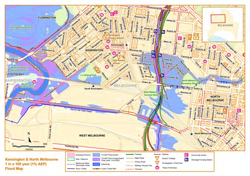
Your local emergency broadcasters are:
                                                                                                                                                                                                                                                ■■ ABC Radio 774 AM
                                                                                                                                                                                                                                                ■■ SKY NEWS Television
                                                                                                                                                                                                                                                City of Melbourne Contact Details:

                                                                                                                                                                                                                                                Ph: 		                           (03) 9658 9658
                                                                                                                                                                                                                                                Fax:		                           (03) 9654 4854
                                                                                                                                                                                                                                                Web:		                           melbourne.vic.gov.au
                                                                                                                                                                                                                                                TTY :		                          133 677 then ask for
                                                                                                                                                                                                                                                			                              (03) 9658 9658
                                                                                                                                                                                                                                                Speak and Listen:                1300 555 727
                                                                                                                                                                                                                                                     then ask for                (03) 9658 9658.

Disclaimer
This map publication is presented by Victoria State Emergency Service for the purpose of disseminating emergency management information. The contents of the information has not been independently verified by Victoria State Emergency Service. No liability is accepted for any damage, loss or injury caused by
errors or omissions in this information or for any action taken by any person in reliance upon it. Flood information is provided by Melbourne Water
Your Local Flood Information                                                                                      Know your risk

                                                                                                                                                       Local Flood Information
The Melbourne Central Business District                                      Did you know?
Melbourne’s Central Business District (CBD) contains the central city        The CBD has a history of flooding, including flooding events in
grid and is bordered by the Yarra River in the south and Victoria            1891, 1972, 1906, 1911, 1916, 1933, 1941, 1954, 1972, 1998, 2004,
Street in the north. The central city is home to retail, financial, legal,   2008, 2010 and 2011.
administrative, recreational, tourist and entertainment facilities and       In February 1972, 78.5 millimetres of rainfall in one hour caused a
operates 24 hours a day, serving a wide variety of residents, workers        wall of water 3-4 feet deep to sweep down Elizabeth Street. Cars
and visitors.                                                                were pushed down the street and a woman had to be rescued
The CBD is highly developed, meaning that rain water is not                  after she fell into deep water because a manhole cover had been
readily absorbed and tends to run off towards lower lying areas.             washed away. The flooding led to significant disruption to public
During high intensity rainfall (more than 20 millimeters per hour,           transport and traffic, and damaged properties and shops.
often during thunderstorms) the amount of run off can lead to
                                                                             More recently, in March 2010, 47 millimetres of rainfall in one hour
stormwater drains overflowing, causing flash flooding. Flash
                                                                             saw floodwater along Elizabeth Street at car-door level and the
flooding occurs with little warning, only lasts a short time and can
                                                                             Flinders Street pedestrian underpass inundated. The hailstones
cause severe localised damage.
                                                                             accompanying the rain blocked stormwater entry pits so water
The map on the previous page shows the expected flooding in a                couldn’t drain away.
1% Annual Exceedance Probability (AEP) flood around the Elizabeth
street drain. A 1% AEP flood means there is a 1% chance of a flood           The City of Melbourne has been working to ensure risk from
this size occurring in any year. Please be aware that even minor             flooding is minimised. Find out about their recent work on
changes in blocked or clear drainage can affect where flooding               drainage at melbourne.vic.gov.au.
occurs.                                                                      While no two floods are the same, floods like this or worse could
The Council drainage network is designed to convey flows from                occur again.
minor storm events underground (typically 10 to 20% AEP). Roads,
laneways, and floodways are designed to convey runoff from                   Tips for Businesses
rainfall events in excess of this capacity. Flooding outside the flood
extents shown in the maps above is possible in a 1% AEP event.               It is not just homes that can be affected by flooding, flooding may
                                                                             also pose a risk to your business.
                                                                             As stories from previous flooding have shown, it can happen at any
                                                                             time and there is very little warning. Think of how much you could
                                                                             lose in stock, equipment and fittings, along with the profits you
                                                                             could lose for the days and weeks cleaning up after the flood. This
                                                                             is why it is important for businesses to prepare for flooding.

                                                                             SES has created an online self-guided Business FloodSafe Toolkit
                                                                             which you can find at ses.vic.gov.au.

                                                                             The Plan does not have to be very complex but it needs to be:
 Melbourne CBD in flood, 1972, from The Age newspaper
                                                                             ■■   written down,
Are you at risk of flood?                                                    ■■   duplicated/ copied and
Elizabeth Street is the lowest point in the CBD and is built on top          ■■   understood by your staff and key stakeholders.
of what was historically a natural creek. Since 1884 the Elizabeth           Improvising or adapting to circumstances at the last minute is not
underground drain has collected stormwater from Carlton and the              wise nor safe and often impacts how the business will recover.
CBD and released it into the Yarra River, which is influenced by the
ocean tide. High tides can impact on the ability of storm water              For more information aimed at business and emergencies visit the
to enter the river from various waterways including the Elizabeth            Small Business Institute emergency portal, tsbi.com.au.
Street drain. This can be a major contributor to flooding along
Elizabeth Street. Increased rubbish can also impact on stormwater
drainage systems.

Additional streets that could be affected by flooding include
Flinders Street, Flinders Lane, Bourke Street and Therry Street. The
entrance to Melbourne Central Station at Elizabeth Street could
also be flooded and specific tram routes affected.

If you live close to the river or in a low-lying area you may be at
risk of flooding. If you live in a high rise building, you might not
be able to leave, so having some emergency food and water
available can help you during flooding. Having a plan is especially
important if you use underground car parking or storage. Even if
you are not directly affected, you may still need to detour around            Melbourne CBD in flood, 1972, from The Age newspaper
flooded areas. Knowing what to do can save your life and help
protect your property.
                                                                                                                        Local Flood Guide          3
City of Melbourne Contact Details:

                                                                                                                                                                                                                                                        Ph: 		                            (03) 9658 9658
                                                                                                                                                                                                                                                        Fax:		                            (03) 9654 4854
                                                                                                                                                                                                                                                        Web:		                            melbourne.vic.gov.au
                                                                                                                                                                                                                                                        TTY :		                           133 677 then ask for
                                                                                                                                                                                                                                                        			                               (03) 9658 9658
                                                                                                                                                                                                                                                        Speak and Listen:                 1300 555 727
                                                                                                                                                                                                                                                             then ask for                 (03) 9658 9658.

                                                                                                                                                                                                                                                                                     Your local emergency
                                                                                                                                                                                                                                                                                     broadcasters are:
                                                                                                                                                                                                                                                                                     ■■ABC Radio 774 AM
                                                                                                                                                                                                                                                                                     ■■SKY NEWS Television

Disclaimer
This map publication is presented by Victoria State Emergency Service for the purpose of disseminating emergency management information. The contents of the information has not been independently verified by Victoria State Emergency Service. No liability is accepted for any damage, loss or injury caused by errors or
omissions in this information or for any action taken by any person in reliance upon it. Flood information is provided by Melbourne Water
Your Local Flood Information                                                                                      Know your risk

                                                                                                                                                                         Local Flood Information
Kensington & North Melbourne local area                               Did you know?
Kensington and North Melbourne are located North West of              Kensington and North Melbourne have a history of flooding,
Melbourne’s central business district. The Moonee Ponds Creek         including flooding in 1906, 1916, 1934, 1974, 1993, 2010 and 2011.
acts as a boundary between the two suburbs and Kensington is          The 1906 flood was the largest on record measuring 5.18 metres at
bordered by the Maribyrnong River on the West.                        the Maribyrnong Gauge.
While Kensington used to house livestock saleyards, North             In 1934, 350 millimetres of rain fell in 48 hours over the Yarra
Melbourne has always been mainly residential due to its proximity     catchment, with 140 millimetres falling over metropolitan areas.
to Melbourne’s city centre. Major parks in the area that serve a      Riverine flooding was widespread with 6,000 people left homeless
double purpose of recreation and temporarily storing excess flood     and 18 deaths.
water when required include Lynch’s Bridge, JJ Holland Park and the
North Melbourne Recreation Reserve.                                    The second largest flood for Kensington occurred in May 1974 with
                                                                       110 millimetres of rain in 48 hours. During this flood, residents
The map on the previous page shows the expected flooding in a
                                                                       around the Maribyrnong River experienced considerable hardship,
1% Annual Exceedance Probability (AEP) flood in Kensington and
                                                                       particularly as the flooding occurred without warning. At this
North Melbourne. A 1% AEP flood means there is a 1% chance of a
                                                                       time, the lower lying areas of Kensington were still home of the
flood this size occurring in any year. Please be aware that even minor
                                                                       stockyards. Flemington Racecourse was out of action until October.
changes in blocked or clear drainage can affect where flooding
                                                                       The flood lead to a real time flood monitoring system being
occurs.
                                                                       established for the catchment by July 1975, to measure rainfall and
                                                                       river levels.
Are you at risk of flood?
                                                                      During the January 2011 rain event, flash flooding affected North
The flat terrain around the Maribyrnong River just before it          Melbourne and Kensington with water over roads. Cars were
meets the Yarra River makes it easier for floodwater to spread        trapped in floodwater in Stubbs Street and McCauley Road and
out along Kensington Road, Hobsons Road, Childers Street              other areas.
and Smithfield Road. Nearby parks and stormwater ponds help
to absorb some of this excess water, but when there is a very         Since then, drains and infrastructure improvements have reduced
large rain event, some roads and public transport may still be        the risk of a similar flood having the same impact. Find out about
impacted for up to 48 hours.                                          recent work on drainage at melbourne.vic.gov.au and to learn
                                                                      more about what the council advises when preparing for floods or
The Moonee Ponds Creek between the two suburbs is bordered            storms.
by a levee to protect neighbouring houses and businesses
when there has been prolonged rainfall north of Melbourne.            While no two floods are the same, floods like this or worse could
                                                                      occur again. Knowing what to do can save your life and help
High intensity, short duration rainfall events can cause flash
                                                                      protect your property.
flooding in Kensington and North Melbourne. Bent Street
and Langford Street (next to Moonee Ponds Creek) can be
particularly affected as water drains from higher areas in            Maribyrnong River flood levels at the
Kensington or North Melbourne. The council has set up six             Maribyrnong Gauge
pumping stations to remove excess water when required. The
area around the Arden Street drain including Errol, Curzon,           When the Bureau of Meteorology (BoM) issues Flood Warnings they
Haines and Abbotsford Streets can also be flooded due to              include a prediction of the flood height at the Maribyrnong Gauge.
topography. Public transport in the area might be affected.           While no two floods are the same, the following table can give you an
Finally it is important to be aware that McCauley Road between        indication of what you can expect at certain heights, including when
Haines Street and Canning Street can also be affected when a          your access may be cut off and when your property may be affected.
severe rain event (34 millimetres or more in an hour) occurs.
Warnings are available for flooding expected along the
                                                                          4.4 m   Height shown on map
Maribyrnong River at Maribyrnong. Melbourne Water does not
provide any flood warning service at Moonee Ponds Creek, due             4.20 m   14th May 1974 flood
to the generally short warning times available.                          3.83 m   15th September 1993 flood
If you live close to a creek, river or in a low-lying area you may      2.90 m    MAJOR FLOOD LEVEL
be at risk of flooding. If you live in a high rise building, you                  Flooding on Bangalore Street and Albermarie Street from Handman Street
might not be able to leave. Having a plan is especially important       2.64 m    30th July 1987 flood
if you use underground car parking or storage. Even if you              2.30 m    MODERATE FLOOD LEVEL
are not directly affected, you may still need to detour around
                                                                                  Maribyrnong River Trail flooded at various locations
flooded areas.
                                                                        2.21 m    14th January 2011 flood
                                                                        1.70 m    MINOR FLOOD LEVEL
                                                                                  Flooding on Smithfield Road, Hobson Road and Kensington Road (especially during high
                                                                                  tide)

                                                                                                                          Local Flood Guide                        5
The Southbank local area
                          Southbank stretches along the banks of the Yarra River from St Kilda Road to Clarendon Street, accommodating one of Melbourne’s primary business centres.
Local Flood Information

                          Areas of Southbank are at risk of flooding from both high water levels in the Yarra River as well as flash flooding caused by heavy rainfall over a short period of time.
                          Many roads and public areas throughout Southbank occupy known flood risk zones, with the total area at risk of flooding potentially expanding due to higher intensity rainfall and rising sea-levels
                          in the future.
                          The map below shows the expected flooding from the Yarra River in Southbank at minor, moderate and major flood levels:
                                                                                                                                                                     Your local emergency broadcasters are:
                                                                                                                                                                     ■■ ABC Radio 774 AM
                                                                                                                                                                     ■■ SKY NEWS Television
                                                                                                                                                                     City of Melbourne Contact Details:

                                                                                                                                                                     Ph: 		                          (03) 9658 9658
                                                                                                                                                                     Fax:		                          (03) 9654 4854
                                                                                                                                                                     Web:		                          melbourne.vic.gov.au
                                                                                                                                                                     TTY :		                         133 677 then ask for
                                                                                                                                                                     			                             (03) 9658 9658
                                                                                                                                                                     Speak and Listen:               1300 555 727
                                                                                                                                                                          then ask for               (03) 9658 9658.

                                                                                                                                                                      Disclaimer
                                                                                                                                                                      This map publication is presented by Victoria State Emergency Service for the purpose of
                                                                                                                                                                      disseminating emergency management information. The contents of the information has
                                                                                                                                                                      not been independently verified by Victoria State Emergency Service. No liability is accepted
                                                                                                                                                                      for any damage, loss or injury caused by errors or omissions in this information or for any
                                                                                                                                                                      action taken by any person in reliance upon it. Flood information is provided by Melbourne
                                                                                                                                                                      Water
Your Local Flood Information                                                                                           Know your risk

                                                                                                                                                                Local Flood Information
Are you at risk of flood?                                                               Did you know?
The Southbank area is prone to river and flash flooding due to                          The Great Flood of 1891 affected riverside suburbs from
high intensity, short rainfall events, and prolonged rainfall along                     Southbank through to Collingwood, Richmond and Prahran when
the Yarra River catchment causing the waterway to overflow                              the Yarra River rose 14 metres above its normal level in some
into surrounding areas. A significant number of business and                            areas. The flooding left approximately 3,000 people homeless.
residential buildings are at risk of flooding.
                                                                                        Since then, drains and infrastructure improvements have reduced
Southbank has a high level of urban development, meaning that
                                                                                        the risk of a repeated event of that scale. Find out about recent
rain water is not readily absorbed into the soil and tends to run
                                                                                        work on drainage at melbourne.vic.gov.au and to learn more
off towards lower lying areas. During high intensity rainfall (more
                                                                                        about what the council advises when preparing for floods or
than 20 millimetres per hour, as can occur during thunderstorms)
                                                                                        storms.
the amount of run off can lead to stormwater drains overflowing,
causing flash flooding. Flash flooding occurs with little warning,                      While no two floods are the same, floods like this or worse could
only lasts a short time and can cause severe localised damage.                          occur again. Knowing what to do can save your life and help
Even minor changes in blocked or clear drainage (through                                protect your property. Southbank residents should be aware of
rubbish, high tide or leaves for example) can affect where flooding                     flood risks, be prepared and have their emergency plans ready
occurs.                                                                                 when flooding occurs.
In the future, the flood risk in these areas could increase due to
higher intensity rain and rising sea-levels resulting from climate
change.

Yarra River Flood Levels at the Spencer Street Gauge
When the Bureau of Meteorology issues flood warnings for Yarra River flooding which may affect Southbank, they include a
prediction of the flood height at the Spencer Street Gauge. While no two floods are the same, the following table can give you an
indication of what you can expect at certain heights, including when your access may be cut off and when your property may be
affected. This gauge may also be affected by tidal flows which may affect the river height and the below is a guide only.
Southbank may also be affected by flash flooding. With the nature of flash flooding, warnings may not be issued so it is vital that you
know what to do to stay safe when flooding starts.

   2.24 m July 1891 flood level

           Floods above major flood level (1.6 metres) result in flooding of buildings,
           road inundation and disruption to the public transport system. Water exceeds
           depths of 0.3 metres on Sturt Street, Moore Street, Kings Street, Moray Street,
           City Road, Kavanagh Street, Queensbridge Street, Whiteman Street, Clarendon
           Street, as well as others in the area. Tram services on routes 1, 55, 96, 109, 112
           are likely to be affected. Major flood level is shown on the map on page 2.
  1.60 m   Major Flood Level

  1.37 m   February 2005 flood level
           At floods above moderate flood level (1.3 metres), the ground floor level of
           some buildings become inundated. Victorian College of the Arts Secondary
           School on Miles Street and the MFC Station on Moray Street become affected
           by flooding on the road. Tram Services on Routes 55, 96, 109 and 112 are likely
           to be affected by flooding. Water exceeds depths of 30 centimetres on Moore
           Street, Miles Street, Kings Street, Moray Street, Hancock Street, Catherine
           Street, Clarke Street, Haig Lane, City Road, Balston Street, Queensbridge Street,
           Whiteman Street and Clarendon Street.
   1.30 m Moderate Flood Level

           At minor flood level, the Yarra Promenade begins to flood.

   1.10 m Minor Flood Level

   1.05 m Flood water inundates Queensbridge Street near Power Street
                                                                                                                            Local Flood Guide               7
About Flood Warnings
About Flood Warnings
What warnings mean Remember, you may not receive any official warning.
Warnings are issued by the Bureau of Meteorology (BoM) to tell Emergency assistance may not be immediately available. Be
people about possible flooding. aware of what is happening around you to stay safe.
Never wait for a warning to act.
A Flood Watch means there is a developing weather pattern that
might cause floods in one or two days.
Emergency Alert
A Flood Warning means flooding is about to happen or is already SES may provide alerts to City of Melbourne residents through
happening. There are minor, moderate and major flood warnings. the Emergency Alert telephone warning system. All emergency
service providers can use Emergency Alert to warn communities
A Minor Flood Warning means floodwater can: about dangerous situations by voice message to landline
telephones or text message to mobile phones.
■■ Reach the top of the river banks.
■■ Come up through drains in nearby streets. If you receive a warning, make sure that all family members,
■■ Cover low-lying areas including riverside camping areas. people at work and your neighbours are aware of the situation.
■■ Affect some low-lying caravan parks.
If you receive an Emergency Alert you should pay attention
■■ Cover minor roads, tracks and low level bridges.
and act. It could mean life or death.
■■ Spread across land or go into buildings on some properties
and farms. If you need help to understand a warning, ask a friend, neighbour
or family member.
A Moderate Flood Warning means floodwater can:
■■ Spill over river banks and spread across low-lying areas. Warnings for Kensington and Southbank
■■ Start to threaten buildings, roads, rail, power and other For the Yarra River and Maribyrnong River, Flood Warnings are
developments. issued by BoM. Flood Warnings provide predictions of flood size
■■ Require evacuation in some areas. (minor, moderate or major), time and possible peaks of the:
■■ Cover main roads. ■■ Yarra River
A Major Flood Warning means floodwater can: See page 6: Spencer Street Gauge
■■ Cause widespread flooding. ■■ Maribyrnong River
■■ Threaten more houses and businesses. See page 4: Maribyrnong Gauge at Maribyrnong
■■ Cause properties and whole areas to be isolated by water.
It is important to know how the predicted flood levels are likely to
■■ Disrupt major roads and transport routes. impact you as you may be affected before the peak.
■■ Require many evacuations.
Use the tables on pages 4 or 6 to figure out when you need to
start following your flood emergency plan.
Victoria State Emergency Service (SES) will give information
about how the floodwater might affect people and properties.
This includes safety messages to remind you what to do during a
flood.
During flash flooding
When flash flooding is likely, if you decide to leave, do so well
Severe Thunderstorm Warnings
before flooding occurs. Leaving early before flooding occurs is
Thunderstorms are classified as severe, due to their potential to
always the safest option. You may decide to shelter with
cause significant localised damage through wind gusts, large hail,
neighbours, family or friends in a safer area.
tornadoes or flash flooding. Severe Thunderstorm Warnings are
issued to the community by BoM.
Evacuating through floodwater is very dangerous and you may be
swept away. Never drive, ride or walk through floodwater.
Severe Weather Warnings
These warnings are issued to the community by BoM when
If you do not leave early enough and become trapped by rising
severe weather is expected that is not directly related to severe
floodwater inside your home or business, stay inside your
thunderstorms or bushfires. Examples of severe weather include
building and seek the highest part such as a second storey.
damaging winds and flash flooding.
Stay there and call Triple Zero (000) if your emergency is life-
Flash flooding happens quickly. City of Melbourne residents
threatening.
should listen out for warnings with flash flooding and remember
that flash flooding:
■■ Occurs so fast that it is difficult to provide a detailed warning.
Often it arrives without warning.
■■ Results from heavy rainfall during short severe storms.
8 Local Flood Guide
8 Local Flood GuidePreparing for Floods Prepare a plan
Preparing for Floods
NOW – before a flood Your emergency plan
■■ Check if your home or business is subject to flooding. For Emergencies can happen at any time, with little warning.
more information, contact the City of Melbourne. People who plan and prepare for emergencies reduce the impact
and recover faster.
■■ Develop an emergency plan.
■■ Check if you could be cut off by floodwater. Taking the time to think about emergencies and make your own
plan helps you think clearly and have more control to make better
■■ Know the safest way to go if you decide to leave your property
decisions when an emergency occurs.
and plan an alternative route.
■■ Check your insurance policies to ensure your equipment, Your emergency plan should identify:
property and business are covered for flood damage.
■■ Keep a list of emergency numbers near the telephone.
■■ The types of emergencies that might affect you.
■■ Put together an emergency kit. ■■ How those emergencies might affect you.
■■ Stay alert for weather warnings and heavy rainfall. ■■ What you will do before, during and after an emergency.
■■ Where to get more information.
When a flood is likely ■■ Where you will go if you evacuate and the best way to go in
different circumstances.
■■ Take action. Follow your emergency plan.
■■ Listen to your radio for information and advice.
■■ A list of phone numbers you will need, including emergency
service providers, your insurance company, friends and family.
■■ Check your neighbours are safe and know about the flood.
■■ Stack possessions on benches and tables with electrical goods
in the highest places.
■■ Anchor objects that are likely to float and cause damage.
■■ Move rubbish bins, chemicals and poisons to the highest
place.
■■ Put important papers, valuables, photos and other special
personal items into your emergency kit.
■■ Business owners should raise stock, business records and
equipment onto benches and tables.
■■ If you are likely to be isolated, have enough food, drinking
water, medicine, fuel and other needs to last at least three
days.
■■ Do not forget pet food and stock feed.
Visit ses.vic.gov.au to obtain a copy of your Home
Emergency Plan workbook
Evacuation
During a flood, Police, SES and other emergency service providers
may advise you to evacuate to keep you safe. It is important that
you follow this advice.
There are two types of evacuation notices that may be issued via
your emergency broadcaster during a flood:
■■ Prepare to evacuate – means you should act quickly and
take immediate action to protect your life and property. Be
ready to leave your property.
■■ Evacuate immediately – you must leave immediately as
there is a risk to lives. You may only have minutes to evacuate
in a flash flooding situation.
Do not return to your home until you are sure it is safe to do so.
You do not need to wait to be told to evacuate.
Local Flood Guide 9Emergency Kit
Home Emergency Kit
Every home and business should have a basic emergency kit:
Copy of your emergency plan Radio Torch Spare batteries Copy of documents & records
Long life food First aid kit
3 days supply
Safe drinking water Gloves
3 days supply
Check your kit often. Make sure things work. Replace out of date items.
When a warning is issued, have ready for use or pack into your kit:
Mobile phone and charger Prescriptions & medicines Pet needs Strong shoes Clothes for your family
3 days supply
3 days supply
I need to add:
Write your list here. Tick items as you pack them into your kit.
Special needs
Photos
Family keepsakes
Valuables
Documents
Other
10 Local Flood Guide
10 Local Flood GuideDuring and After a Flood
During and After a Flood
During a flood How SES helps the community
When flooding has begun: Victoria State Emergency Service (SES) is a volunteer based
emergency service provider. Although SES volunteers attempt
■■ Never drive, ride, swim or walk through floodwater. to reach everyone prior to or during an emergency, at times this
■■ Remember that floodwater can be deeper than you think and is not possible, especially during flash flooding which occurs
can hide damaged roads and bridges. so quickly. Therefore it is advisable for you to be prepared for
emergencies so that you can share responsibility for your own
■■ Never let your children play or swim in floodwater. It is dirty, wellbeing during those times. In a flood, SES assistance may
dangerous and deadly. include:
■■ Tune in to your emergency broadcasters: ABC Local Radio,
■■ Giving flood advice
Commercial Radio, designated Community Radio Stations
and SKY NEWS Television. ■■ Protecting essential services
■■ In life-threatening emergencies, call Triple Zero (000). ■■ Helping to protect infrastructure
■■ For SES emergency assistance during floods and storms call ■■ Rescuing people from floodwater
132 500.
■■ Advising of an evacuation
■■ Stay away from all waterways including drains and culverts.
■■ Stay away from fallen powerlines as electricity travels easily
through water. To assist your preparation, it is recommended that you obtain a
copy of the SES Home Emergency Plan by visiting
■■ Be aware that animals such as snakes, rats, spiders and other ses.vic.gov.au.
pests may be on the move during a flood. These animals
can come into houses and other buildings or hide around
sandbags.
■■ Keep in contact with neighbours.
■■ Be prepared to act quickly.
After a flood
Flood dangers do not end when the water begins to fall. To make
sure you stay safe:
■■ Keep listening to local emergency broadcasters.
■■ Do not return home until you are sure that it is safe.
Once you return to your home:
■■ Investigate the structural safety of your building.
■■ Drink bottled water or boil all drinking water until advised
that the water supply is safe.
■■ Throw away any food or medicines that may have been in
contact with floodwater or affected by power outages.
■■ When entering a building, use a torch to light your
way. Never use matches or cigarette lighters as there may be
gas inside.
■■ Keep the electricity and gas off until checked and tested by a
professional.
■■ Take photographs of all damage for insurance.
■■ Clean your home straight away to prevent disease.
Local Flood Guide 11
Local Flood Guide 11Emergency Checklist Emergency Contacts
Checklist and Contacts
NOW: Flood preparation Triple Zero
Life-threatening emergency 000
■■ Check if your insurance policy cover flooding. Police Fire Ambulance TTY106
■■ Keep this list of emergency numbers near the telephone.
■■ Put together an emergency kit and prepare a home or business Victoria State Emergency Service (SES)
For SES emergency assistance 132 500
emergency plan, see ses.vic.gov.au.
When you hear a Flood Watch or weather warning SES information line 1300 842 737
Operates during major floods or storms 1300 VIC SES
■■ Listen to Severe Weather Warnings for flash flood.
VicEmergency
■■ Listen to the radio and check the SES website for more
Victorian emergency warnings
emergency.vic.gov.au
information and advice.
■■ Go over your emergency plan. Pack clothing and other extra Bureau of Meteorology (BoM) 1300 659 217
items into your emergency kit and take this with you if you Weather information, forecasts, warnings bom.gov.au
evacuate.
National Relay Service (NRS) relayservice.gov.au
■■ Leave early if you intend to evacuate.
The deaf, hearing or speech impaired can call SES or Triple Zero (000) using NRS:
When flooding may happen soon (heavy rainfall) Dial Then Ask For
■■ Speak and Listen (SSR) users phone 1300 555 727 132 500
■■ Make sure your family members and neighbours are aware of
what is happening. ■■ TTY / Voice users phone 13 36 77 132 500
■■ Conditions change rapidly, roads and escape routes can Internet Relay users log into iprelay.com.au/call/
be covered or blocked. Don’t forget to take pets and your then enter: 132 500 or 000
medicine with you.
■■ Put household valuables and electrical items as high as VicRoads 13 11 70
possible. Road closures and hazard reporting service vicroads.vic.gov.au
■■
Version : EMPC-LFG-98.0 March 2016
Turn off water, gas and electricity at the mains. City of Melbourne Contact Details
■■ Secure objects likely to float and cause damage. Ph: (03) 9658 9658
Fax: (03) 9654 4854
■■ If you are staying in a caravan or temporary dwelling, move to Web: melbourne.vic.gov.au
higher ground before flooding begins. TTY : 133 677 then ask for (03) 9658 9658
Speak and Listen: 1300 555 727 then ask for(03) 9658 9658.
During the flood
Weather District: Central
■■ For SES emergency assistance, call 132 500.
Catchment: Melbourne Water
■■ Do not drive, ride, swim or walk through floodwater. This is
the main cause of death during floods. Emergency Broadcasters
■■ NEVER allow children to play in floodwater. This is the main Emergency broadcasters include ABC
Local Radio, designated commercial radio
■■ ABC Radio 774 AM
cause of death during floods for children and young people.
stations across Victoria and SKY NEWS
■■ SKY NEWS Television
■■ Stay away from drains, culverts and waterways as water can Television.
flow quickly and have strong currents. Complete the following and keep this information
handy close to the phone:
■■ Stay well clear of fallen trees, powerlines and damaged
For the latest version of this publication visit ses.vic.gov.au
buildings. Your electricity supplier:
After the flood: recovery
Your gas supplier:
■■ If your property has been flooded, check with the City of
Melbourne for information and advice.
■■ Have all electrical and gas equipment professionally tested Doctor:
before use.
Vet:
For more information visit:
Insurance
ses.vic.gov.au Policy Number:
facebook.com/vicses
twitter.com/vicseswarnings Phone Number:You can also read